
Flood Susceptibility Modeling Using an Advanced Deep Learning-Based Iterative Classifier Optimizer

 , ,
, ,  and
and 
Abstract
:1. Introduction
2. Materials and Methods
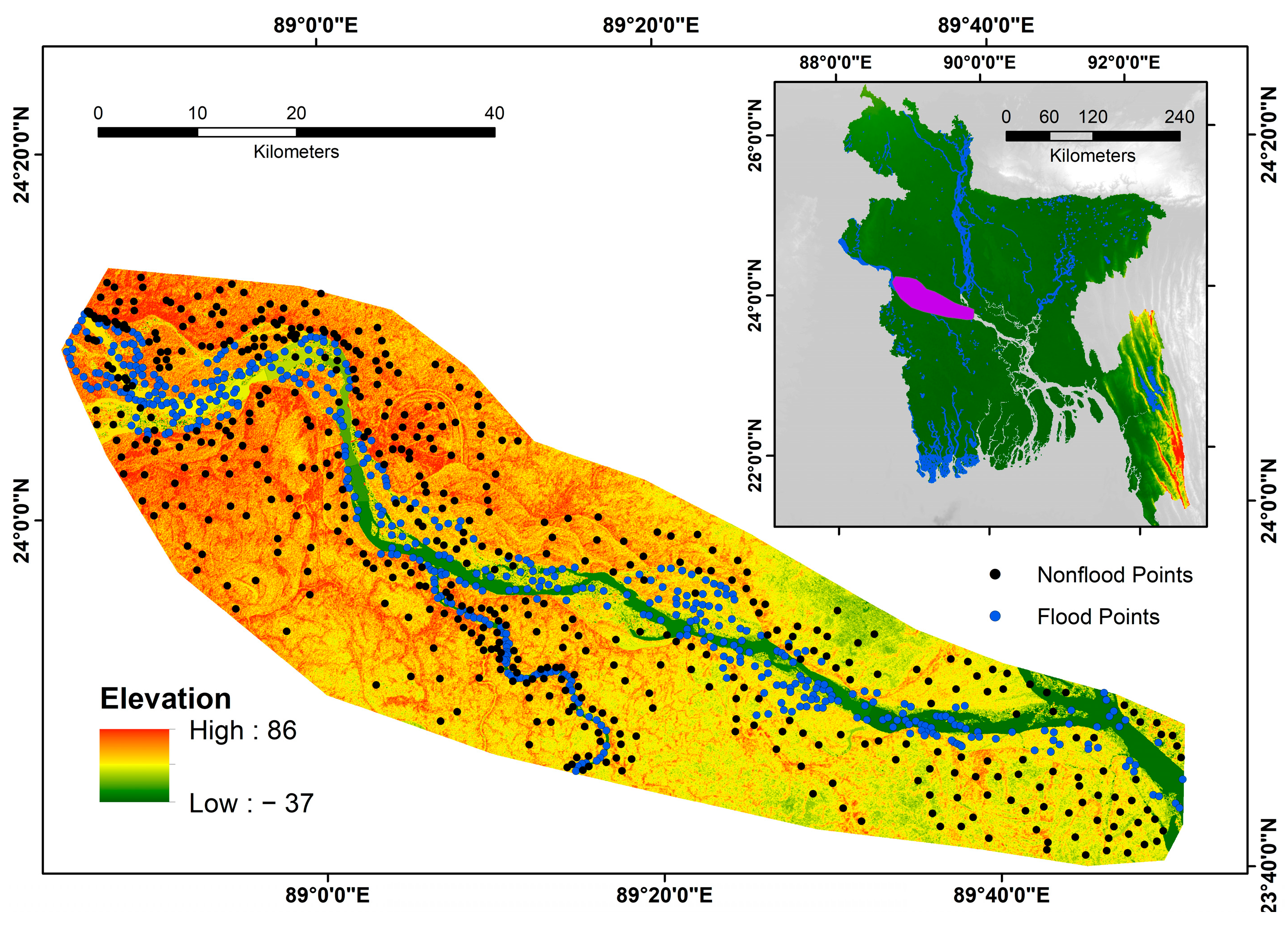
2.1. Study Area
2.2. Preparation of the Data
- (1)
- Flood causal variables were prepared for this study.
- (2)
- Datasets were demarcated into two components: training and testing, where the training data were then integrated into the deep learning models, and the hyperparameters for each method were tuned properly.
- (3)
- Deep learning methods were applied to detect how each important conditioning variable is in flood incidence.

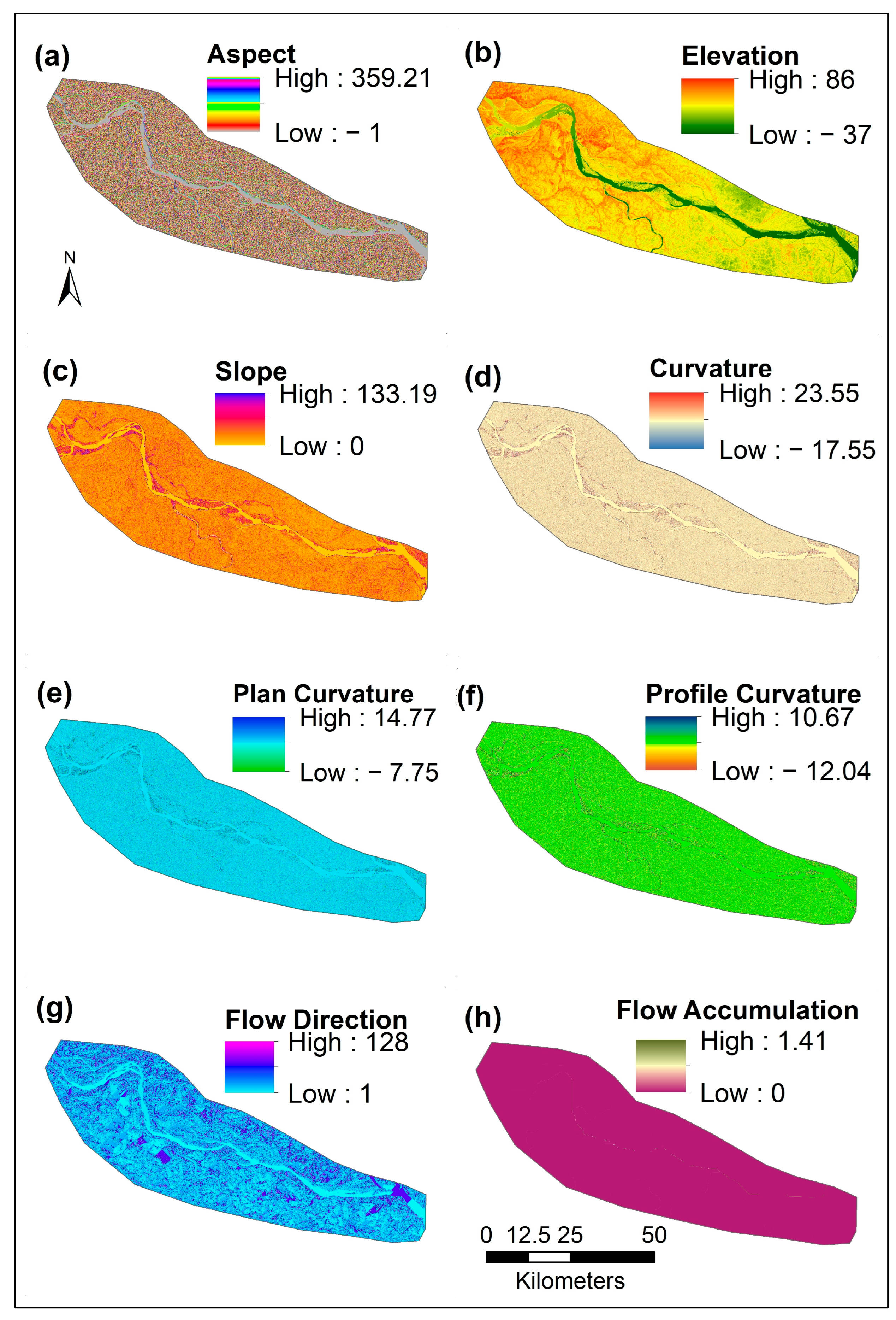
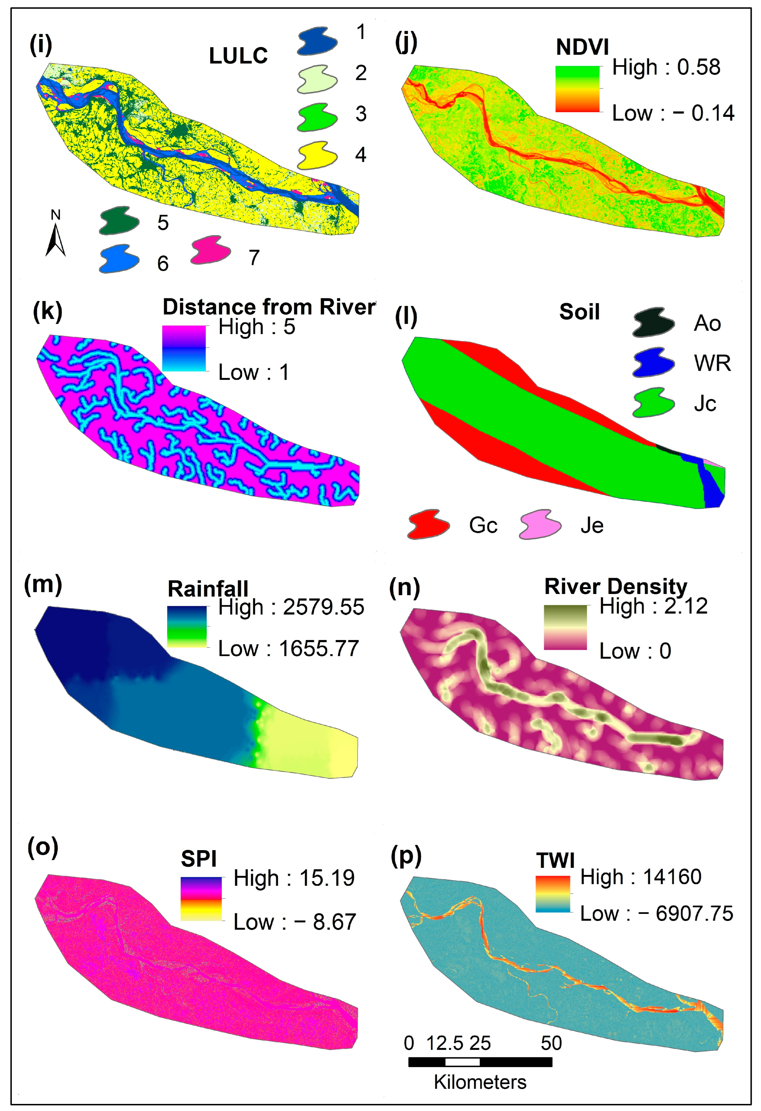
2.2.1. Preparing of Causal Variables
2.2.2. Dividing a Database
2.2.3. Flood Conditional Variable Preparation
2.3. Flood Susceptibility Assessment
2.3.1. Alternating Decision Tree (ADT)
2.3.2. Naïve Bayes (NB)
2.3.3. Artificial Neural Network (ANN)
2.3.4. Deep Learning Neural Network (DLNN)
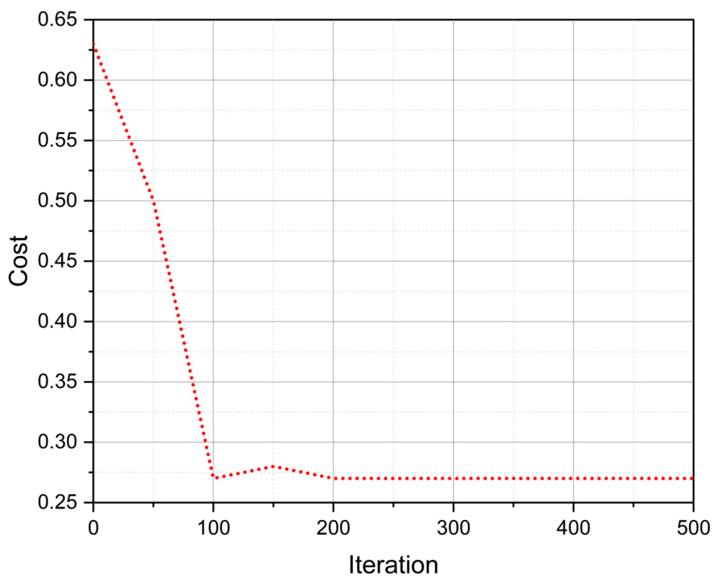
2.4. Iterative Classifier Optimizer (ICO)
2.5. Multicollinearity Assessment
2.6. Validation Methods for the Models
2.7. Graphical Representation
3. Results
3.1. Multicollinearity Assessment
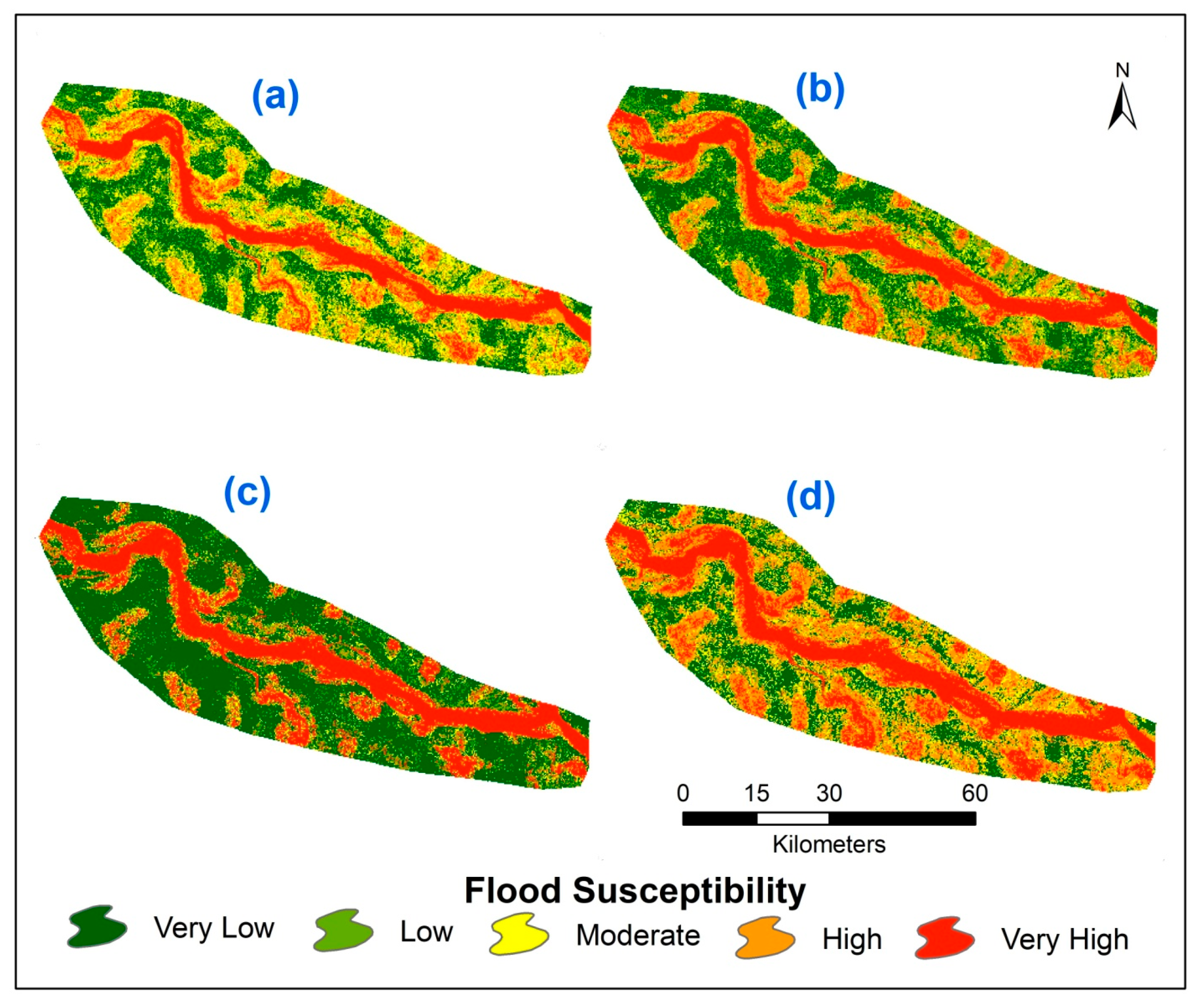
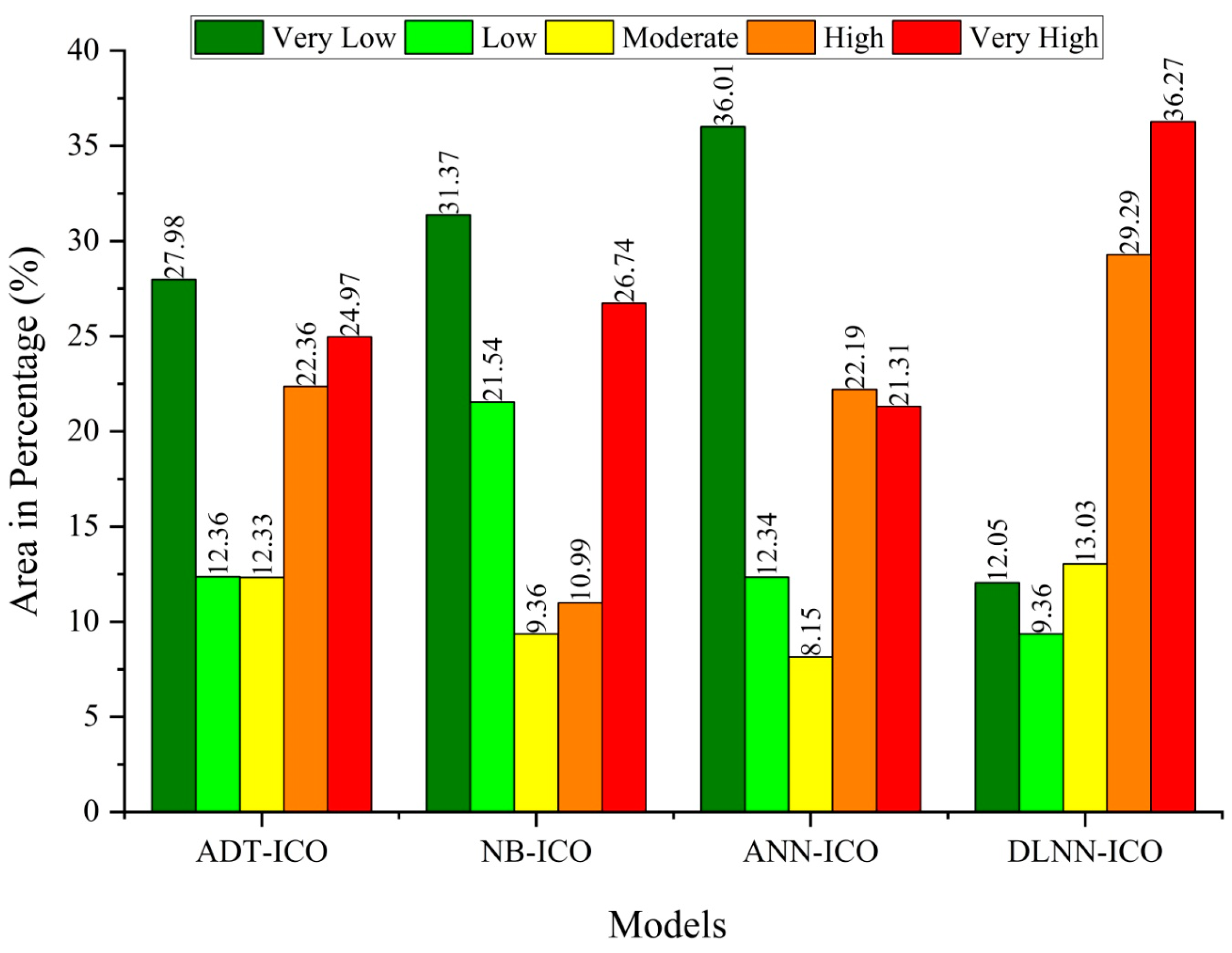
3.2. Floods Susceptibility (FS) Assessments
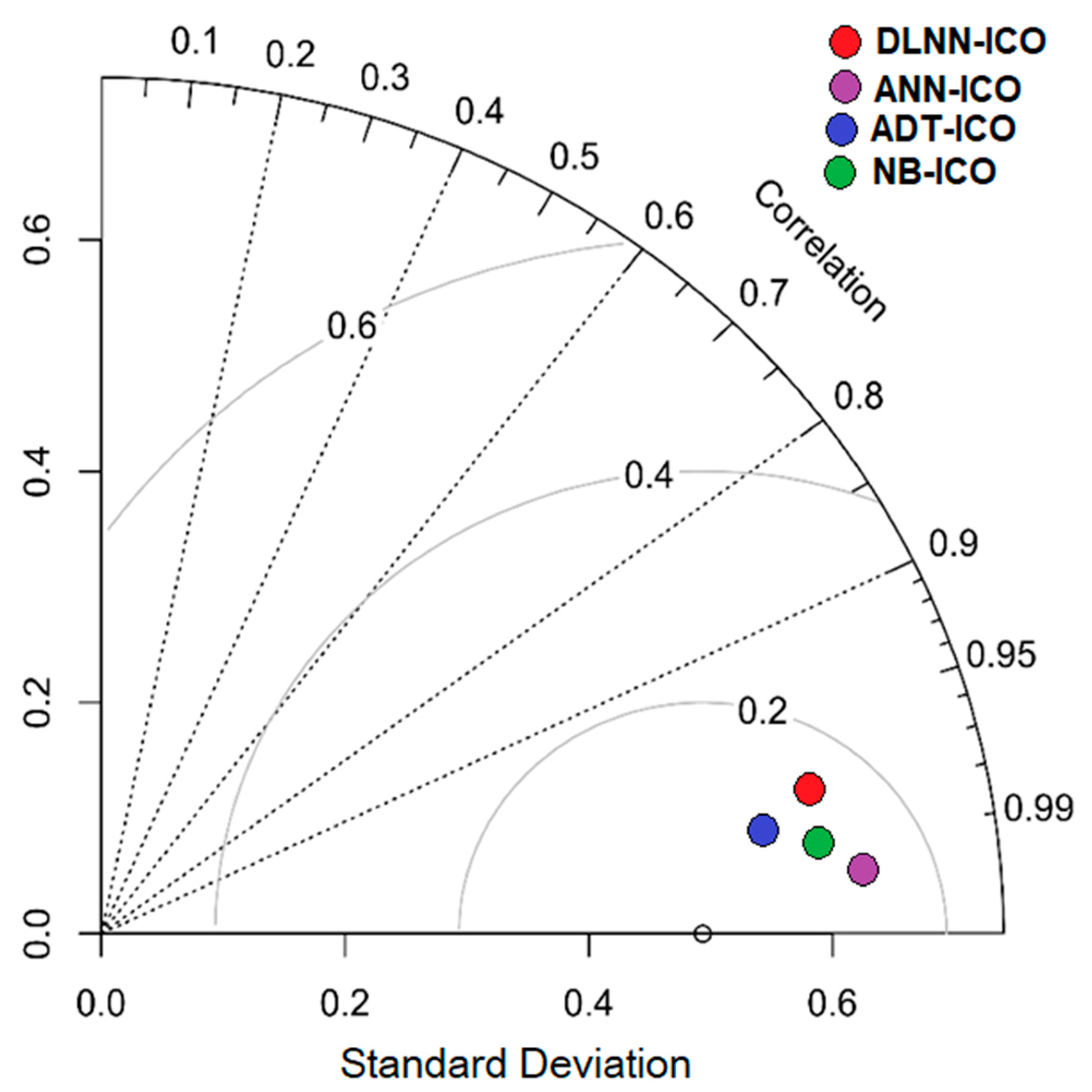
3.3. Validation
3.4. Importance of the Variables
4. Discussion
5. Conclusions
Author Contributions
Funding
Data Availability Statement
Acknowledgments
Conflicts of Interest
References
- Hirabayashi, Y.; Mahendran, R.; Koirala, S.; Konoshima, L.; Yamazaki, D.; Watanabe, S.; Kim, H.; Kanae, S. Global flood risk under climate change. Nat. Clim. Change 2013, 3, 816–821. [Google Scholar] [CrossRef]
- Khosravi, K.; Melesse, A.M.; Shahabi, H.; Shirzadi, A.; Chapi, K.; Hong, H. Flood susceptibility mapping at Ningdu catchment, China using bivariate and data mining techniques. In Extreme Hydrology and Climate Variability; Elsevier: Amsterdam, The Netherlands, 2019; pp. 419–434. [Google Scholar]
- Ruidas, D.; Chakrabortty, R.; Islam, A.R.M.T.; Saha, A.; Pal, S.C. A novel hybrid of meta-optimization approach for flash flood-susceptibility assessment in a monsoon-dominated watershed, Eastern India. Environ. Earth Sci. 2022, 81, 145. [Google Scholar] [CrossRef]
- Mia, M.U.; Rahman, M.; Elbeltagi, A.; Abdullah-Al-Mahbub, M.; Sharma, G.; Islam, H.T.; Pal, S.C.; Costache, R.; Islam, A.R.M.T.; Islam, M.M.; et al. Sustainable flood risk assessment using deep learning-based algorithms with a blockchain technology. Geocarto Int. 2022, 1–31. [Google Scholar] [CrossRef]
- Rahman, M.; Chen, N.; Islam, M.M.; Dewan, A.; Pourghasemi, H.R.; Washakh, R.M.A.; Nepal, N.; Tian, S.; Faiz, H.; Alam, M. Location-allocation modeling for emergency evacuation planning with GIS and remote sensing: A case study of Northeast Bangladesh. Geosci. Front. 2020, 12, 101095. [Google Scholar] [CrossRef]
- Zhang, Q.; Gu, X.; Singh, V.P.; Shi, P.; Sun, P. More frequent flooding? Changes in flood frequency in the Pearl River basin, China, since 1951 and over the past 1000 years. Hydrol. Earth Syst. Sci. 2018, 22, 2637–2653. [Google Scholar] [CrossRef] [Green Version]
- Dottori, F.; Salamon, P.; Bianchi, A.; Alfieri, L.; Hirpa, F.A.; Feyen, L. Development and evaluation of a framework for global flood hazard mapping. Adv. Water Resour. 2016, 94, 87–102. [Google Scholar] [CrossRef]
- Hoque, M.A.A.; Tasfia, S.; Ahmed, N.; Pradhan, B. Assessing spatial flood vulnerability at KalaparaUpazila in Bangladesh using an analytic hierarchy process. Sensors 2019, 19, 1302. [Google Scholar] [CrossRef] [PubMed] [Green Version]
- Fernandez, P.; Mourato, S.; Moreira, M. Social vulnerability assessment of flood risk using GIS-based multicriteria decision analysis. A case study of Vila Nova de Gaia (Portugal). Geomat. Nat. Hazards Risk 2016, 7, 1367–1389. [Google Scholar] [CrossRef] [Green Version]
- Wang, Y.; Li, Z.; Tang, Z.; Zeng, G. A GIS-based spatial multi-criteria approach for flood risk assessment in the Dongting Lake Region, Hunan, Central China. Water Resour. Manag. 2011, 25, 3465–3484. [Google Scholar] [CrossRef]
- Tien Bui, D.; Khosravi, K.; Shahabi, H.; Daggupati, P.; Adamowski, J.F.; Melesse, A.M.; Thai Pham, B.; Pourghasemi, H.R.; Mahmoudi, M.; Bahrami, S.; et al. Flood spatial modeling in northern Iran using remote sensing and gis: A comparison between evidential belief functions and its ensemble with a multivariate logistic regression model. Remote Sens. 2019, 11, 1589. [Google Scholar] [CrossRef] [Green Version]
- Bubeck, P.; Thieken, A.H. What helps people recover from floods? Insights from a survey among flood-affected residents in Germany. Reg. Environ. Change 2018, 18, 287–296. [Google Scholar] [CrossRef]
- Ali, R.; Kuriqi, A.; Abubaker, S.; Kisi, O. Long-term trends and seasonality detection of the observed flow in Yangtze River using Mann-Kendall and Sen’s innovative trend method. Water 2019, 11, 1855. [Google Scholar] [CrossRef] [Green Version]
- Alexander, K.; Hettiarachchi, S.; Ou, Y.; Sharma, A. Can integrated green spaces and storage facilities absorb the increased risk of flooding due to climate change in developed urban environments. J. Hydrol. 2019, 579, 124201. [Google Scholar] [CrossRef]
- Huang, K.; Li, X.; Liu, X.; Seto, K.C. Projecting global urban land expansion and heat island intensification through 2050. Environ. Res. Lett. 2019, 14, 114037. [Google Scholar] [CrossRef] [Green Version]
- Jahandideh-Tehrani, M.; Zhang, H.; Helfer, F.; Yu, Y. Review of climate change impacts on predicted river streamflow in tropical rivers. Environ. Monit. Assess. 2019, 191, 752. [Google Scholar] [CrossRef]
- Xu, L.; Wang, X.; Liu, J.; He, Y.; Tang, J.; Nguyen, M.; Cui, S. Identifying the trade-offs between climate change mitigation and adaptation in urban land use planning: An empirical study in a coastal city. Environ. Int. 2019, 133, 105162. [Google Scholar] [CrossRef]
- Sarker, M.N.I.; Alam, G.M.M.; Firdaus, R.B.R.; Biswas, J.C.; Islam, A.R.M.T.; Raihan, M.L.; Hattori, T.; Alam, K.; Joshi, N.P.; Shaw, R. Assessment of flood vulnerability of riverine island community using a composite flood vulnerability index. Int. J. Disaster Risk Reduct. 2022, 82, 103306. [Google Scholar] [CrossRef]
- Cao, Q.; Mehran, A.; Ralph, F.M.; Lettenmaier, D.P. The role of hydrological initial conditions on Atmospheric River floods in the Russian River basin. J. Hydrometeorol. 2019, 20, 1667–1686. [Google Scholar] [CrossRef]
- Su, J.; Lü, H.; Zhu, Y.; Cui, Y.; Wang, X. Evaluating the hydrological utility of latest IMERG products over the Upper Huaihe River Basin, China. Atmos. Res. 2019, 225, 17–29. [Google Scholar] [CrossRef]
- Costache, R.; Hong, H.; Pham, Q.B. Comparative assessment of the flash-flood potential within small mountain catchments using bivariate statistics and their novel hybrid integration with machine learning models. Sci. Total Environ. 2020, 711, 134514. [Google Scholar] [CrossRef]
- Tien Bui, D.; Shirzadi, A.; Shahabi, H.; Chapi, K.; Omidavr, E.; Pham, B.T.; Talebpour Asl, D.; Khaledian, H.; Pradhan, B.; Panahi, M.; et al. A novel ensemble artificial intelligence approach for gully erosion mapping in a semi-arid watershed (Iran). Sensors 2019, 19, 2444. [Google Scholar] [CrossRef] [PubMed] [Green Version]
- Bui, D.T.; Hoang, N.D.; Martínez-Álvarez, F.; Ngo, P.T.T.; Hoa, P.V.; Pham, T.D.; Samui, P.; Costache, R. A novel deep learning neural network approach for predicting flash flood susceptibility: A case study at a high frequency tropical storm area. Sci. Total Environ. 2020, 701, 134413. [Google Scholar]
- Siegel, F.R. Structures That Protect Coastal Populations, Assets, and GDPs: Sea Dikes, Breakwaters, Seawalls. In Adaptations of Coastal Cities to Global Warming, Sea Level Rise, Climate Change and Endemic Hazards; Springer Briefs in Environmental Science; Springer: Cham, Switzerland, 2020; pp. 11–25. [Google Scholar] [CrossRef]
- Brinkmann, R. Wicked Problems and Disasters. Environmental Sustainability in a Time of Change. Palgrave Studies in Environmental Sustainability; Palgrave Macmillan: Cham, Switzerland, 2020; pp. 55–82. [Google Scholar] [CrossRef]
- Luino, F.; De Graff, J.; Roccati, A.; Biddoccu, M.; Cirio, C.G.; Faccini, F.; Turconi, L. Eighty years of data collected for the determination of rainfall threshold triggering shallow landslides and mud-debris flows in the Alps. Water 2020, 12, 133. [Google Scholar] [CrossRef] [Green Version]
- Kuriqi, A.; Ardiçlioglu, M.; Muceku, Y. Investigation of seepage effect on river dike’s stability under steady state and transient conditions. Pollack Period. 2016, 11, 87–104. [Google Scholar] [CrossRef] [Green Version]
- Kuriqi, A.; Ardiçlioǧlu, M. Investigation of hydraulic regime at middle part of the Loire River in context of floods and low flow events. Pollack Period. 2018, 13, 145–156. [Google Scholar] [CrossRef]
- Bui, Q.T.; Nguyen, Q.H.; Nguyen, X.L.; Pham, V.D.; Nguyen, H.D.; Pham, V.M. Verification of novel integrations of swarm intelligence algorithms into deep learning neural network for flood susceptibility mapping. J. Hydrol. 2020, 581, 124379. [Google Scholar] [CrossRef]
- Munir, B.A.; Ahmad, S.R.; Hafeez, S. Integrated hazard modeling for simulating torrential stream response to flash flood events. ISPRS Int. J. Geo. Inf. 2020, 9, 1. [Google Scholar] [CrossRef] [Green Version]
- Okaka, W.T. Climate Change-Induced Flood Disaster Policy Communication Issues for Local Community Adaptation Resilience Management in Uganda: Climate Information Services for Effective National Flood Risk Assessment Decision Communication. In Decision Support Methods for Assessing Flood Risk and Vulnerability; IGI Global: Pennsylvania, PA, USA, 2020; pp. 230–249. [Google Scholar]
- Sinha, D.K. Natural Disaster Reduction: South East Asian Realities, Risk Perception and Global Strategies; Anthem Press: London, UK, 2007. [Google Scholar]
- Mallick, J.; Salam, R.; Amin, R.; Islam, A.R.M.T.; Islam, A.; Siddik, M.N.A.; Alam, G.M. Assessing factors affecting drought, earthquake, and flood risk perception: Empirical evidence from Bangladesh. Nat. Hazards 2022, 112, 1633–1656. [Google Scholar] [CrossRef]
- Gazi, M.Y.; Islam, M.A.; Hossain, S. Flood-hazard mapping in a regional scale way forward to the future hazard atlas in Bangladesh. Malays. J. Geosci. 2019, 3, 1–11. [Google Scholar] [CrossRef]
- Rahman, M.; Chen, N.; Elbeltagi, A.; Islam, M.M.; Alam, M.; Pourghasemi, H.R.; Tao, W.; Zhang, J.; Shufeng, T.; Faiz, H.; et al. Application of stacking hybrid machine learning algorithms in delineating multi-type flooding in Bangladesh. J. Environ. Manag. 2021, 295, 113086. [Google Scholar] [CrossRef]
- Sarkar, S.K.; Ansar, S.B.; Ekram, K.M.M.; Khan, M.H.; Talukdar, S.; Naikoo, M.W.; Islam, A.R.M.T.; Rahman, A.; Mosavi, A. Developing Robust Flood Susceptibility Model with Small Numbers of Parameters in Highly Fertile Regions of Northwest Bangladesh for Sustainable Flood and Agriculture Management. Sustainability 2022, 14, 3982. [Google Scholar] [CrossRef]
- Ahmed, N.; Hoque, M.A.A.; Arabameri, A.; Pal, S.C.; Chakrabortty, R.; Jui, J. Flood susceptibility mapping in Brahmaputra floodplain of Bangladesh using deep boost, deep learning neural network, and artificial neural network. Geocarto Int. 2021, 37, 8770–8791. [Google Scholar] [CrossRef]
- Bonafilia, D.; Tellman, B.; Anderson, T.; Issenberg, E. Sen1Floods11: A georeferenced dataset to train and test deep learning flood algorithms for sentinel-1. In Proceedings of the IEEE/CVF Conference on Computer Vision and Pattern Recognition Workshops, Seattle, WA, USA, 14–19 June 2020; pp. 210–211. [Google Scholar]
- Sahana, M.; Rehman, S.; Sajjad, H.; Hong, H. Exploring effectiveness of frequency ratio and support vector machine models in storm surge flood susceptibility assessment: A study of Sundarban Biosphere Reserve, India. Catena 2020, 189, 104450. [Google Scholar] [CrossRef]
- Chen, W.; Hong, H.; Li, S.; Shahabi, H.; Wang, Y.; Wang, X.; Ahmad, B.B. Flood susceptibility modelling using novel hybrid approach of reduced-error pruning trees with bagging and random subspace ensembles. J. Hydrol. 2019, 575, 864–873. [Google Scholar] [CrossRef]
- Bui, D.T.; Ngo, P.T.T.; Pham, T.D.; Jaafari, A.; Minh, N.Q.; Hoa, P.V.; Samui, P. A novel hybrid approach based on a swarm intelligence optimized extreme learning machine for flash flood susceptibility mapping. Catena 2019, 179, 184–196. [Google Scholar] [CrossRef]
- Mahmood, S.; Rahman, A.U. Flash flood susceptibility modeling using geo-morphometric and hydrological approaches in Panjkora Basin, Eastern Hindu Kush, Pakistan. Environ. Earth Sci. 2019, 78, 1–16. [Google Scholar] [CrossRef]
- Hong, H.; Panahi, M.; Shirzadi, A.; Ma, T.; Liu, J.; Zhu, A.X.; Chen, W.; Kougias, I.; Kazakis, N. Flood susceptibility assessment in Hengfeng area coupling adaptive neuro-fuzzy inference system with genetic algorithm and differential evolution. Sci. Total Environ. 2018, 621, 1124–1141. [Google Scholar] [CrossRef]
- Termeh, S.V.R.; Kornejady, A.; Pourghasemi, H.R.; Keesstra, S. Flood susceptibility mapping using novel ensembles of adaptive neuro fuzzy inference system and metaheuristic algorithms. Sci. Total Environ. 2018, 615, 438–451. [Google Scholar] [CrossRef]
- Siahkamari, S.; Haghizadeh, A.; Zeinivand, H.; Tahmasebipour, N.; Rahmati, O. Spa- tial prediction of flood-susceptible areas using frequency ratio and maximum en- tropy models. Geocarto Int. 2018, 33, 927–941. [Google Scholar] [CrossRef]
- Souissi, D.; Zouhri, L.; Hammami, S.; Msaddek, M.H.; Zghibi, A.; Dlala, M. GIS-based MCDM–AHP modeling for flood susceptibility mapping of arid areas, southeastern Tunisia. Geocarto Int. 2019, 35, 991–1017. [Google Scholar] [CrossRef]
- Dano, U.L.; Balogun, A.L.; Matori, A.N.; Wan Yusouf, K.; Abubakar, I.R.; Said Mohamed, M.A.; Aina, Y.A.; Pradhan, B. Flood susceptibility mapping using GIS-based analytic network process: A case study of Perlis, Malaysia. Water 2019, 11, 615. [Google Scholar] [CrossRef] [Green Version]
- Nachappa, T.G.; Piralilou, S.T.; Gholamnia, K.; Ghorbanzadeh, O.; Rahmati, O.; Blaschke, T. Flood susceptibility mapping with machine learning, multi-criteria decision analysis and ensemble using Dempster Shafer Theory. J. Hydrol. 2020, 590, 125275. [Google Scholar] [CrossRef]
- Chen, J.; Li, Q.; Wang, H.; Deng, M. A machine learning ensemble approach based on random forest and radial basis function neural network for risk evaluation of regional flood disaster: A case study of the Yangtze River Delta, China. Int. J. Environ. Res. Public Health 2020, 17, 49. [Google Scholar] [CrossRef] [PubMed] [Green Version]
- Moghaddam, D.D.; Pourghasemi, H.R.; Rahmati, O. Assessment of the contribution of geo-environmental factors to flood inundation in a semi-arid region of SW Iran: Comparison of different advanced modeling approaches. In Natural Hazards GIS-Based Spatial Modeling Using Data Mining Techniques; Springer: Cham, Switzerland, 2019; pp. 59–78. [Google Scholar]
- Xu, C. Assessment of earthquake-triggered landslide susceptibility based on expert knowledge and information value methods: A case study of the 20 April 2013 Lushan, China Mw6. 6 earthquakes. Disaster Adv. 2013, 6, 119–130. [Google Scholar]
- Chen, W.; Li, W.; Hou, E.; Zhao, Z.; Deng, N.; Bai, H.; Wang, D. Landslide susceptibility mapping based on GIS and information value model for the Chencang District of Baoji, China. Arab. J. Geosci. 2014, 7, 4499–4511. [Google Scholar] [CrossRef]
- ShafapourTehrany, M.; Kumar, L.; NeamahJebur, M.; Shabani, F. Evaluating the application of the statistical index method in flood susceptibility mapping and its comparison with frequency ratio and logistic regression methods. Geomat. Nat. Haz. Risk. 2019, 10, 79–101. [Google Scholar] [CrossRef] [Green Version]
- Pham, B.T.; Phong, T.V.; Nguyen, H.D.; Qi, C.; Al-Ansari, N.; Amini, A.; Ho, L.S.; Tuyen, T.T.; Yen, H.P.H.; Ly, H.B.; et al. A comparative study of kernel logistic regression, radial basis function classifier, multinomial naïve bayes, and logistic model tree for flash flood susceptibility mapping. Water 2020, 12, 239. [Google Scholar] [CrossRef] [Green Version]
- Ali, S.A.; Parvin, F.; Pham, Q.B.; Vojtek, M.; Vojteková, J.; Costache, R.; Linh, N.T.T.; Nguyen, H.Q.; Ahmad, A.; Ghorbani, M.A. GIS-based comparative assessment of flood susceptibility mapping using hybrid multi-criteria decision-making approach, naïve Bayes tree, bivariate statistics and logistic regression: A case of Topľa basin, Slovakia. Ecol. Indic. 2020, 117, 106620. [Google Scholar] [CrossRef]
- Chen, W.; Panahi, M.; Tsangaratos, P.; Shahabi, H.; Ilia, I.; Panahi, S.; Li, S.; Jaafari, A.; Ahmad, B.B. Applying population-based evolutionary algorithms and a neuro-fuzzy system for modeling landslide susceptibility. Catena 2019, 172, 212–231. [Google Scholar] [CrossRef]
- Paul, G.C.; Saha, S.; Hembram, T.K. Application of the GIS-based probabilistic models for mapping the flood susceptibility in Bansloi sub-basin of Ganga-Bhagirathi River and their comparison. Remote Sens. Earth Syst. Sci. 2019, 2, 120–146. [Google Scholar] [CrossRef]
- Wang, Y.; Hong, H.; Chen, W.; Li, S.; Pamučar, D.; Gigović, L.; Drobnjak, S.; Tien Bui, D.; Duan, H. A hybrid GIS multi-criteria decision-making method for flood susceptibility mapping at Shangyou, China. Remote Sens. 2018, 11, 62. [Google Scholar] [CrossRef] [Green Version]
- Sahana, M.; Patel, P.P. A comparison of frequency ratio and fuzzy logic models for flood susceptibility assessment of the lower Kosi River Basin in India. Environ. Earth Sci. 2019, 78, 289. [Google Scholar] [CrossRef]
- Hong, H.; Tsangaratos, P.; Ilia, I.; Liu, J.; Zhu, A.X.; Chen, W. Application of fuzzy weight of evidence and data mining techniques in construction of flood susceptibility map of Poyang County, China. Sci. Total Environ. 2018, 625, 575–588. [Google Scholar] [CrossRef] [PubMed]
- Wang, Y.; Fang, Z.; Hong, H.; Peng, L. Flood susceptibility mapping using convolutional neural network frameworks. J. Hydrol. 2020, 582, 124482. [Google Scholar] [CrossRef]
- Shahabi, H.; Shirzadi, A.; Ghaderi, K.; Omidvar, E.; Al-Ansari, N.; Clague, J.J.; Geertsema, M.; Khosravi, K.; Amini, A.; Bahrami, S.; et al. Flood detection and susceptibility mapping using sentinel-1 remote sensing data and a machine learning approach: Hybrid intelligence of bagging ensemble based on k-nearest neighbor classifier. Remote Sens. 2020, 12, 266. [Google Scholar] [CrossRef] [Green Version]
- Dodangeh, E.; Choubin, B.; Eigdir, A.N.; Nabipour, N.; Panahi, M.; Shamshirband, S.; Mosavi, A. Integrated machine learning methods with resampling algorithms for flood susceptibility prediction. Sci. Total 2020, 705, 135983. [Google Scholar] [CrossRef]
- Oeurng, C.; Sauvage, S.; Sánchez-Pérez, J.M. Assessment of hydrology, sediment and particulate organic carbon yield in a large agricultural catchment using the SWAT model. J. Hydrol. 2011, 401, 145–153. [Google Scholar] [CrossRef] [Green Version]
- Getahun, Y.S.; Gebre, S.L. Flood hazard assessment and mapping of flood inundation area of the Awash River Basin in Ethiopia using GIS and HEC-GeoRAS/HEC-RAS model. J. Civ. Environ. Eng. 2015, 5, 1. [Google Scholar]
- Khosravi, K.; Pham, B.T.; Chapi, K.; Shirzadi, A.; Shahabi, H.; Revhaug, I.; Prakash, I.; Bui, D.T. A comparative assessment of decision trees algorithms for flash flood susceptibility modeling at Haraz watershed, northern Iran. Sci. Total Environ. 2018, 627, 744–755. [Google Scholar] [CrossRef]
- Janizadeh, S.; Avand, M.; Jaafari, A.; Phong, T.V.; Bayat, M.; Ahmadisharaf, E.; Prakash, I.; Pham, B.T.; Lee, S. Prediction success of machine learning methods for flash flood susceptibility mapping in the Tafresh watershed, Iran. Sustainability 2019, 11, 5426. [Google Scholar] [CrossRef] [Green Version]
- Chen, W.; Li, Y.; Xue, W.; Shahabi, H.; Li, S.; Hong, H.; Wang, X.; Bian, H.; Zhang, S.; Pradhan, B.; et al. Modeling flood susceptibility using data-driven approaches of naïve bayes tree, alternating decision tree, and random forest methods. Sci. Total Environ. 2020, 701, 134979. [Google Scholar] [CrossRef]
- Falah, F.; Rahmati, O.; Rostami, M.; Ahmadisharaf, E.; Daliakopoulos, I.N.; Pourghasemi, H.R. Artificial neural networks for flood susceptibility mapping in data-scarce urban areas. In Spatial Modeling in GIS and R for Earth and Environmental Sciences; Elsevier: Amsterdam, The Netherlands, 2019; pp. 323–336. [Google Scholar]
- Pham, B.T.; Jaafari, A.; Avand, M.; Al-Ansari, N.; Dinh Du, T.; Yen, H.P.H.; Phong, T.V.; Nguyen, D.H.; Le, H.V.; Mafi-Gholami, D.; et al. Performance evaluation of machine learning methods for forest fire modeling and prediction. Symmetry 2020, 12, 1022. [Google Scholar] [CrossRef]
- Chakrabortty, R.; Pal, S.C.; Janizadeh, S.; Santosh, M.; Roy, P.; Chowdhuri, I.; Saha, A. Impact of climate change on future flood susceptibility: An evaluation based on deep learning algorithms and GCM model. Water Resour. Manag. 2021, 35, 4251–4274. [Google Scholar] [CrossRef]
- Garcia-Garcia, A.; Orts-Escolano, S.; Oprea, S.; Villena-Martinez, V.; Martinez-Gonzalez, P.; GarciaRodriguez, J. A survey on deep learning techniques for image and video semantic segmentation. Appl. Soft Comput. 2018, 70, 41. [Google Scholar] [CrossRef]
- Costache, R.; Tin, T.T.; Arabameri, A.; Crăciun, A.; Ajin, R.S.; Costache, I.; Islam, A.R.M.T.; Abba, S.I.; Sahana, M.; Avand, M.; et al. Flash-flood hazard using deep learning based on H2O R package and fuzzy-multicriteria decision-making analysis. J. Hydrol. 2022, 609, 127747. [Google Scholar] [CrossRef]
- Torres, J.; Galicia, A.; Troncoso, A.; Martínez-Álvarez, F. A scalable approach based on deep learning for big data time series forecasting. Integr. Comput. Aided Eng. 2018, 25, 335–348. [Google Scholar] [CrossRef]
- Shafizadeh-Moghadam, H.; Valavi, R.; Shahabi, H.; Chapi, K.; Shirzadi, A. Novel forecasting approaches using combination of machine learning and statistical models for flood susceptibility mapping. J. Environ. Manag. 2018, 217, 1–11. [Google Scholar] [CrossRef] [Green Version]
- Pham, B.T.; Bui, D.T.; Prakash, I.; Dholakia, M.B. Hybrid integration of Multilayer Perceptron Neural Networks and machine learning ensembles for landslide susceptibility assessment at Himalayan area (India) using GIS. Catena 2017, 149, 52–63. [Google Scholar] [CrossRef]
- Ghasemain, B.; Asl, D.T.; Pham, B.T.; Avand, M.; Nguyen, H.D.; Janizadeh, S.J.V.J.O.E.S. Shallow landslide susceptibility mapping: A comparison between classification and regression tree and reduced error pruning tree algorithms. Vietnam J. Earth Sci. 2020, 42, 208–227. [Google Scholar] [CrossRef]
- Pham, B.T.; Phong, T.V.; Nguyen-Thoi, T.; Parial, K.; Singh, K.; Ly, H.B.; Nguyen, K.T.; Ho, L.S.; Le, H.V.; Prakash, I. Ensemble modeling of landslide susceptibility using random subspace learner and different decision tree classifiers. Geocarto Int. 2021, 37, 735–757. [Google Scholar] [CrossRef]
- Tang, X.; Li, J.; Liu, M.; Liu, W.; Hong, H. Flood susceptibility assessment based on a novel random Naïve Bayes method: A comparison between different factor discretization methods. Catena 2020, 190, 104536. [Google Scholar] [CrossRef]
- Islam, A.R.M.T.; Talukdar, S.; Akhter, S.; Eibek, K.U.; Rahman, M.; Pal, S.; Naikoo, M.W.; Rahman, A.; Mosavi, A. Assessing the Impact of the Farakka Barrage on Hydrological Alteration in the Padma River with Future Insight. Sustainability 2022, 14, 5233. [Google Scholar] [CrossRef]
- Dewan, A.; Corner, R.; Saleem, A.; Rahman, M.M.; Haider, M.R.; Rahman, M.M.; Sarker, M.H. Assessing channel changes of the Ganges-Padma River system in Bangladesh using Landsat and hydrological data. Geomorphology 2017, 276, 257–279. [Google Scholar] [CrossRef]
- Islam, A.R.M.T.; Talukdar, S.; Mahato, S.; Kundu, S.; Eibek, K.U.; Pham, Q.B.; Kuriqi, A.; Linh, N.T.T. Machine learning algorithm-based risk assessment of riparian wetlands in Padma River Basin of Northwest Bangladesh. Environ. Sci. Pollut. Res. 2021, 28, 34450–34471. [Google Scholar] [CrossRef]
- Hossain, M.Y. Morphometric relationships of length-weight and length-length of four Cyprinid small indigenous fish species from the Padma River (NW Bangladesh). Turk. J. Fish. Aquat. Sci. 2010, 10, 131–134. [Google Scholar] [CrossRef]
- Sarkar, D.; Mondal, P. Flood vulnerability mapping using frequency ratio (FR) model: A case study on Kulik river basin, Indo-Bangladesh Barind region. Appl. Water Sci. 2020, 10, 17. [Google Scholar] [CrossRef] [Green Version]
- Islam, A.R.M.T.; Talukdar, S.; Mahato, S.; Kundu, S.; Eibek, K.U.; Pham, Q.B.; Kuriqi, A.; Linh, N.T.T. Flood susceptibility modelling using advanced ensemble machine learning models. Geosci. Front. 2021, 12, 12101075. [Google Scholar]
- Wubalem, A.; Tesfaw, G.; Dawit, Z.; Getahun, B.; Mekuria, T.; Jothimani, M. Comparison of statistical and analytical hierarchy process methods on flood susceptibility mapping: In a case study of Tana sub-basin in northwestern Ethiopia. Nat. Hazards Earth Syst. Sci. Discuss 2020, 332, 1–43. [Google Scholar]
- Rahman, M.; Ningsheng, C.; Islam, M.M.; Dewan, A.; Iqbal, J.; Washakh, R.M.A.; Shufeng, T. Flood susceptibility assessment in Bangladesh using machine learning and multi-criteria decision analysis. Earth Syst. Environ. 2019, 3, 585–601. [Google Scholar] [CrossRef]
- Kim, H.I.; Han, K.Y. Urban flood prediction using deep neural network with data augmentation. Water 2019, 12, 899. [Google Scholar] [CrossRef] [Green Version]
- Available online: https://chrsdata.eng.uci.edu/ (accessed on 13 October 2022).
- Nguyen, V.T.; Tran, T.H.; Ha, N.A.; Ngo, V.L.; Nadhir, A.A.; Tran, V.P.; Duy Nguyen, H.; MA, M.; Amini, A.; Prakash, I.; et al. GIS based novel hybrid computational intelligence models for mapping landslide susceptibility: A case study at da lat city, Vietnam. Sustainability 2019, 11, 7118. [Google Scholar] [CrossRef] [Green Version]
- Kourgialas, N.N.; Karatzas, G.P. Flood management and a GIS modelling method to assess flood-hazard areas—A case study. Hydrol. Sci. J. J. Des Sci. Hydrol. 2011, 56, 212–225. [Google Scholar] [CrossRef]
- Available online: https://earthexplorer.usgs.gov/ (accessed on 15 October 2022).
- Available online: https://www.usgs.gov/programs/energy (accessed on 20 November 2022).
- Available online: https://www.fao.org (accessed on 12 December 2022).
- Yi, Y.; Zhang, Z.; Zhang, W.; Jia, H.; Zhang, J. Landslide susceptibility mapping using multiscale sampling strategy and convolutional neural network: A case study in Jiuzhaigou region. Catena 2020, 195, 104851. [Google Scholar] [CrossRef]
- Pham, B.T.; Luu, C.; Van Phong, T.; Trinh, P.T.; Shirzadi, A.; Renoud, S.; Asadi, S.; Van Le, H.; von Meding, J.; Clague, J.J. Can deep learning algorithms outperform benchmark machine learning algorithms in flood susceptibility modeling. J. Hydrol. 2021, 592, 125615. [Google Scholar] [CrossRef]
- Costache, R.; Arabameri, A.; Costache, I.; Crăciun, A.; Islam, A.R.M.T.; Abba, S.I.; Sahana, M.; Pham, B.T. Flood susceptibility evaluation through deep learning optimizer ensembles and GIS techniques. J. Environ. Manag. 2022, 316, 115316. [Google Scholar] [CrossRef]
- Nhu, V.H.; Zandi, D.; Shahabi, H.; Chapi, K.; Shirzadi, A.; Al-Ansari, N.; Singh, S.K.; Dou, J.; Nguyen, H. Comparison of support vector machine, Bayesian logistic regression, and alternating decision tree algorithms for shallow landslide susceptibility mapping along a mountainous road in the west of Iran. Appl. Sci. 2020, 10, 5047. [Google Scholar] [CrossRef]
- Costache, R.; Arabameri, A.; Blaschke, T.; Pham, Q.B.; Pham, B.T.; Pandey, M.; Arora, A.; Linh, N.T.T.; Costache, I. Flash-flood potential mapping using deep learning, alternating decision trees and data provided by remote sensing sensors. Sensors 2021, 21, 280. [Google Scholar] [CrossRef] [PubMed]
- Wang, H.; Wang, H.; Wu, Z.; Zhou, Y. Using multi-factor analysis to predict urban flood depth based on Naive Bayes. Water 2021, 13, 432. [Google Scholar] [CrossRef]
- Sellami, E.M.; Maanan, M.; Rhinane, H. Performance of machine learning algorithms for mapping and forecasting of flash flood susceptibility in Tetouan, Morocco. Int. Arch. Photogramm. Remote Sens. Spat. Inf. Sci. 2022, 46, 305–313. [Google Scholar] [CrossRef]
- Kia, M.B.; Pirasteh, S.; Pradhan, B.; Mahmud, A.R.; Sulaiman, W.N.A.; Moradi, A. An artificial neural network model for flood simulation using GIS: Johor River Basin, Malaysia. Environ. Earth Sci. 2012, 67, 251–264. [Google Scholar] [CrossRef]
- Kalantar, B.; Ueda, N.; Saeidi, V.; Janizadeh, S.; Shabani, F.; Ahmadi, K.; Shabani, F. Deep neural network utilizing remote sensing datasets for flood hazard susceptibility mapping in Brisbane, Australia. Remote Sens. 2021, 13, 2638. [Google Scholar] [CrossRef]
- Costache, R.; Arabameri, A.; Moayedi, H.; Pham, Q.B.; Santosh, M.; Nguyen, H.; Pandey, M.; Pham, B.T. Flash-flood potential index estimation using fuzzy logic combined with deep learning neural network, naïve Bayes, XGBoost and classification and regression tree. Geocarto Int. 2021, 37, 6780–6807. [Google Scholar] [CrossRef]
- Khosravi, K.; Safari, M.J.S.; Cooper, J.R. Clear-water scour depth prediction in long channel contractions: Application of new hybrid machine learning algorithms. Ocean. Eng. 2021, 238, 109721. [Google Scholar] [CrossRef]
- Khosravi, K.; Barzegar, R.; Golkarian, A.; Busico, G.; Cuoco, E.; Mastrocicco, M.; Colombani, N.; Tedesco, D.; Ntona, M.M.; Kazakis, N. Predictive modeling of selected trace elements in groundwater using hybrid algorithms of iterative classifier optimizer. J. Contam. Hydrol. 2021, 242, 103849. [Google Scholar] [CrossRef] [PubMed]
- Mitra, R.; Saha, P.; Das, J. Assessment of the performance of GIS-based analytical hierarchical process (AHP) approach for flood modelling in Uttar Dinajpur district of West Bengal, India. Geomat. Nat. Hazards Risk 2022, 13, 2183–2226. [Google Scholar] [CrossRef]
- Saha, S.; Saha, A.; Hembram, T.K.; Kundu, B.; Sarkar, R. Novel Ensemble of Deep Learning Neural Network and Support Vector Machine for Landslide Susceptibility Mapping in Tehri Region, Garhwal Himalaya. Geocarto Int. 2022, 37, 17018–17043. [Google Scholar] [CrossRef]
- Khosravi, K.; Shahabi, H.; Pham, B.T.; Adamowski, J.; Shirzadi, A.; Pradhan, B.; Dou, J.; Ly, H.B.; Gróf, G.; Ho, H.L.; et al. A comparative assessment of flood susceptibility modeling using multi-criteria decision-making analysis and machine learning methods. J. Hydrol. 2019, 573, 311–323. [Google Scholar] [CrossRef]
- Arora, A.; Arabameri, A.; Pandey, M.; Siddiqui, M.A.; Shukla, U.K.; Bui, D.T.; Mishra, V.N.; Bhardwaj, A. Optimization of state-of-the-art fuzzy metaheuristic ANFIS-based machine learning models for flood susceptibility prediction mapping in the Middle Ganga Plain, India. Sci. Total Environ. 2021, 750, 141565. [Google Scholar] [CrossRef] [PubMed]
- Al-Aizari, A.R.; Al-Masnay, Y.A.; Aydda, A.; Zhang, J.; Ullah, K.; Islam, A.R.M.T.; Habib, T.; Kaku, D.U.; Nizeyimana, J.C.; Al-Shaibah, B.; et al. Assessment Analysis of Flood Susceptibility in Tropical Desert Area: A Case Study of Yemen. Remote Sens. 2022, 14, 4050. [Google Scholar] [CrossRef]
- Band, S.S.; Janizadeh, S.; Chandra Pal, S.; Saha, A.; Chakrabortty, R.; Shokri, M.; Mosavi, A. Novel ensemble approach of deep learning neural network (DLNN) model and particle swarm optimization (PSO) algorithm for prediction of gully erosion susceptibility. Sensors 2020, 20, 5609. [Google Scholar] [CrossRef] [PubMed]
- Luu, C.; Pham, B.T.; Van Phong, T.; Costache, R.; Nguyen, H.D.; Amiri, M.; Bui, Q.D.; Nguyen, L.T.; Van Le, H.; Prakash, I.; et al. GIS-Based Ensemble Computational models for Flood Susceptibility Prediction in the Quang Binh Province, Vietnam. J. Hydrol. 2021, 599, 126500. [Google Scholar] [CrossRef]
- Tehrany, M.S.; Pradhan, B.; Mansor, S.; Ahmad, N. Flood susceptibility assessment using GIS-based support vector machine model with different kernel types. Catena 2015, 125, 91–101. [Google Scholar] [CrossRef]
- Riazi, M.; Khosravi, K.; Shahedi, K.; Ahmad, S.; Jun, C.; Bateni, S.M.; Kazaki, N. Enhancing flood susceptibility modeling using multi temporal Sar images, CHIRPS data and hybrid machine learning algorithms. Sci. Total Environ. 2023, 871, 161066. [Google Scholar] [CrossRef] [PubMed]
- Hong, H.; Pradhan, B.; Xu, C.; Bui, D.T. Spatial prediction of landslide hazard at the Yihuang area (China) using two-class kernel logistic regression, alternating decision tree and support vector machines. Catena 2015, 133, 266–281. [Google Scholar] [CrossRef]
- Sevgen, E.; Kocaman, S.; Nefeslioglu, H.A.; Gokceoglu, C. A novel performance assessment approach using photogrammetric techniques for landslide susceptibility mapping with logistic regression, ANN and random forest. Sensors 2019, 19, 3940. [Google Scholar] [CrossRef] [Green Version]
- Lee, S.; Lee, M.J.; Jung, H.S.; Lee, S. Landslide susceptibility mapping using Naïve Bayes and Bayesian network models in Umyeonsan, Korea. Geocarto Int. 2020, 35, 1665–1679. [Google Scholar] [CrossRef]
- Pham, B.T.; Avand, M.; Janizadeh, S.; Phong, T.V.; Al-Ansari, N.; Ho, L.S.; Das, S.; Le, H.V.; Amini, A.; Bozchaloei, S.K.; et al. GIS based hybrid computational approaches for flash flood susceptibility assessment. Water 2020, 12, 683. [Google Scholar] [CrossRef] [Green Version]
- Zhao, G.; Pang, B.; Xu, Z.; Yue, J.; Tu, T. Mapping flood susceptibility in mountainous areas on a national scale in China. Sci. Total Environ. 2018, 615, 1133–1142. [Google Scholar] [CrossRef]
- Chakrabortty, R.; Chandra Pal, S.; Rezaie, F.; Arabameri, A.; Lee, S.; Roy, P.; Saha, A.; Chowdhuri, I.; Moayedi, H. Flash-flood hazard susceptibility mapping in Kangsabati River Basin, India. Geocarto Int. 2021, 37, 6713–6735. [Google Scholar] [CrossRef]
- Pal, S.C.; Chakrabortty, R.; Arabameri, A.; Santosh, M.; Saha, A.; Chowdhuri, I.; Roy, P.; Shit, M. Chemical weathering and gully erosion causing land degradation in a complex river basin of Eastern India: An integrated field, analytical and artificial intelligence approach. Nat. Hazards 2022, 110, 847–879. [Google Scholar] [CrossRef]
- Arabameri, A.; AsadiNalivan, O.; Saha, S.; Roy, J.; Pradhan, B.; Tiefenbacher, J.P.; Thi Ngo, P.T. Novel ensemble approaches of machine learning techniques in modeling the gully erosion susceptibility. Remote Sens. 2020, 12, 1890. [Google Scholar] [CrossRef]
- Saha, A.; Pal, S.C.; Chowdhuri, I.; Islam, A.R.M.T.; Chakrabortty, R.; Roy, P. Application of neural network model-based framework approach to identify gully erosion potential hotspot zones in sub-tropical environment. Geocarto Int. 2022, 37, 14758–14784. [Google Scholar] [CrossRef]
- Arabameri, A.; Chen, W.; Loche, M.; Zhao, X.; Li, Y.; Lombardo, L.; Cerda, A.; Pradhan, B.; Bui, D.T. Comparison of machine learning models for gully erosion susceptibility mapping. Geosci. Front. 2020, 11, 1609–1620. [Google Scholar] [CrossRef]
- Chowdhuri, I.; Pal, S.C.; Saha, A.; Chakrabortty, R.; Roy, P. Evaluation of different DEMs for gully erosion susceptibility mapping using in-situ field measurement and validation. Ecol. Inform. 2021, 65, 101425. [Google Scholar] [CrossRef]
- Chen, W.; Zhou, Y.; Zhou, E.; Xiang, Z.; Zhou, W.; Lu, J. Wildfire risk assessment of transmission-line corridors based on naïve bayes network and remote sensing data. Sensors 2021, 21, 634. [Google Scholar] [CrossRef]
- Tella, A.; Balogun, A.L.; Adebisi, N.; Abdullah, S. Spatial assessment of PM10 hotspots using random forest, K-nearest neighbour and Naïve Bayes. Atmos. Pollut. Res. 2021, 12, 101202. [Google Scholar] [CrossRef]
- Nguyen, H.D. Hybrid models based on deep learning neural network and optimization algorithms for the spatial prediction of tropical forest fire susceptibility in Nghe An province, Vietnam. Geocarto Int. 2022, 37, 11281–11305. [Google Scholar] [CrossRef]
- Costache, R.; Tin, T.T.; Arabameri, A.; Crăciun, A.; Costache, I.; Islam, A.R.M.T.; Sahana, M.; Pham, B.T. Stacking state-of-the-art ensemble for flash-flood potential assessment. Geocarto Int. 2022, 37, 13812–13838. [Google Scholar] [CrossRef]
- Bui, D.T.; Tsangaratos, P.; Nguyen, V.T.; Van Liem, N.; Trinh, P.T. Comparing the prediction performance of a Deep Learning Neural Network model with conventional machine learning models in landslide susceptibility assessment. Catena 2020, 188, 104426. [Google Scholar] [CrossRef]


| Sl. No. | Variables | Collinearity | |
|---|---|---|---|
| TOL | VIF | ||
| 1 | Aspect | 0.453 | 2.208 |
| 2 | Elevation | 0.336 | 2.976 |
| 3 | Slope | 0.499 | 2.004 |
| 4 | Curvature | 0.638 | 1.567 |
| 5 | Plan curvature | 0.913 | 1.095 |
| 6 | Profile curvature | 0.561 | 1.783 |
| 7 | Flow direction | 0.391 | 2.558 |
| 8 | Flow accumulation | 0.559 | 1.789 |
| 9 | LULC | 0.369 | 2.710 |
| 10 | NDVI | 0.779 | 1.284 |
| 11 | Distance from River | 0.652 | 1.534 |
| 12 | Soil | 0.449 | 2.227 |
| 13 | Rainfall | 0.305 | 3.279 |
| 14 | River density | 0.297 | 3.367 |
| 15 | SPI | 0.369 | 2.710 |
| 16 | TWI | 1.245 | 0.803 |
| 17 | STI | 0.951 | 1.052 |
| 18 | Geology | 0.993 | 1.007 |
| Models | Complete Dataset | Prediction | Total | Correct (%) | Wrong (%) | Sensitivity | Specificity | Recall | F score | PPV | NPV | AUC | ||
|---|---|---|---|---|---|---|---|---|---|---|---|---|---|---|
| Nonflood (0) | Flood (1) | |||||||||||||
| Training | DLNN-ICO | 0 | 274 | 40 | 314 | 195.714 | 18.571 | 0.909 | 0.873 | 0.909 | 0.887 | 0.867 | 0.913 | 0.932 |
| 1 | 26 | 260 | 286 | 185.714 | 20.000 | |||||||||
| Total | 300 | 300 | 600 | 190.714 | 19.286 | |||||||||
| ADT-ICO | 0 | 264 | 40 | 304 | 188.571 | 25.714 | 0.878 | 0.868 | 0.878 | 0.872 | 0.867 | 0.880 | 0.891 | |
| 1 | 36 | 260 | 296 | 185.714 | 20.000 | |||||||||
| Total | 300 | 300 | 600 | 187.143 | 22.857 | |||||||||
| NB-ICO | 0 | 260 | 44 | 304 | 185.714 | 28.571 | 0.865 | 0.855 | 0.865 | 0.859 | 0.853 | 0.867 | 0.873 | |
| 1 | 40 | 256 | 296 | 182.857 | 22.000 | |||||||||
| Total | 300 | 300 | 600 | 184.286 | 25.286 | |||||||||
| ANN-ICO | 0 | 258 | 52 | 310 | 184.286 | 30.000 | 0.855 | 0.832 | 0.855 | 0.841 | 0.827 | 0.860 | 0.835 | |
| 1 | 42 | 248 | 290 | 177.143 | 26.000 | |||||||||
| Total | 300 | 300 | 600 | 180.714 | 28.000 | |||||||||
| Validation | DLNN-ICO | 0 | 130 | 18 | 148 | 92.857 | 14.286 | 0.868 | 0.878 | 0.868 | 0.874 | 0.880 | 0.867 | 0.917 |
| 1 | 20 | 132 | 152 | 94.286 | 9.000 | |||||||||
| Total | 150 | 150 | 300 | 93.571 | 11.643 | |||||||||
| ADT-ICO | 0 | 128 | 20 | 148 | 91.429 | 15.714 | 0.855 | 0.865 | 0.855 | 0.861 | 0.867 | 0.853 | 0.864 | |
| 1 | 22 | 130 | 152 | 92.857 | 10.000 | |||||||||
| Total | 150 | 150 | 300 | 92.143 | 12.857 | |||||||||
| NB-ICO | 0 | 126 | 24 | 150 | 90.000 | 17.143 | 0.840 | 0.840 | 0.840 | 0.840 | 0.840 | 0.840 | 0.845 | |
| 1 | 24 | 126 | 150 | 90.000 | 12.000 | |||||||||
| Total | 150 | 150 | 300 | 90.000 | 14.571 | |||||||||
| ANN-ICO | 0 | 123 | 24 | 147 | 87.857 | 19.286 | 0.824 | 0.837 | 0.824 | 0.832 | 0.840 | 0.820 | 0.801 | |
| 1 | 27 | 126 | 153 | 90.000 | 12.000 | |||||||||
| Total | 150 | 150 | 300 | 88.929 | 15.643 | |||||||||
| Parameters | AD-ICO | NB-ICO | ANN-ICO | DLNN-ICO |
|---|---|---|---|---|
| Aspect | 14 | 9 | 12 | 15 |
| Elevation | 50 | 40 | 55 | 65 |
| Slope | 35 | 35 | 30 | 40 |
| Curvature | 20 | 15 | 25 | 20 |
| Plan curvature | 20 | 20 | 30 | 15 |
| Profile curvature | 10 | 20 | 15 | 20 |
| Flow direction | 15 | 25 | 20 | 10 |
| Flow accumulation | 30 | 35 | 20 | 15 |
| LULC | 20 | 20 | 35 | 25 |
| NDVI | 20 | 30 | 25 | 20 |
| Distance from River | 70 | 75 | 70 | 80 |
| Soil | 30 | 35 | 25 | 30 |
| Rainfall | 70 | 60 | 65 | 70 |
| River density | 40 | 45 | 50 | 50 |
| SPI | 30 | 30 | 35 | 30 |
| TWI | 15 | 20 | 20 | 10 |
| STI | 20 | 25 | 20 | 30 |
| Geology | 20 | 20 | 25 | 25 |
Disclaimer/Publisher’s Note: The statements, opinions and data contained in all publications are solely those of the individual author(s) and contributor(s) and not of MDPI and/or the editor(s). MDPI and/or the editor(s) disclaim responsibility for any injury to people or property resulting from any ideas, methods, instructions or products referred to in the content. |
© 2023 by the authors. Licensee MDPI, Basel, Switzerland. This article is an open access article distributed under the terms and conditions of the Creative Commons Attribution (CC BY) license (https://creativecommons.org/licenses/by/4.0/).
Share and Cite
Mia, M.U.; Chowdhury, T.N.; Chakrabortty, R.; Pal, S.C.; Al-Sadoon, M.K.; Costache, R.; Islam, A.R.M.T. Flood Susceptibility Modeling Using an Advanced Deep Learning-Based Iterative Classifier Optimizer. Land 2023, 12, 810. https://doi.org/10.3390/land12040810
Mia MU, Chowdhury TN, Chakrabortty R, Pal SC, Al-Sadoon MK, Costache R, Islam ARMT. Flood Susceptibility Modeling Using an Advanced Deep Learning-Based Iterative Classifier Optimizer. Land. 2023; 12(4):810. https://doi.org/10.3390/land12040810
Chicago/Turabian StyleMia, Md. Uzzal, Tahmida Naher Chowdhury, Rabin Chakrabortty, Subodh Chandra Pal, Mohammad Khalid Al-Sadoon, Romulus Costache, and Abu Reza Md. Towfiqul Islam. 2023. "Flood Susceptibility Modeling Using an Advanced Deep Learning-Based Iterative Classifier Optimizer" Land 12, no. 4: 810. https://doi.org/10.3390/land12040810
APA StyleMia, M. U., Chowdhury, T. N., Chakrabortty, R., Pal, S. C., Al-Sadoon, M. K., Costache, R., & Islam, A. R. M. T. (2023). Flood Susceptibility Modeling Using an Advanced Deep Learning-Based Iterative Classifier Optimizer. Land, 12(4), 810. https://doi.org/10.3390/land12040810