Article

Storing Grain in the Land: The Gestation, Delineation Framework, and Case of the Two Zones Policy in China

College of Earth Science, Jilin University, Changchun 130061, China
*
Author to whom correspondence should be addressed.
Land 2023, 12(4), 806; https://doi.org/10.3390/land12040806
Submission received: 2 February 2023 / Revised: 16 March 2023 / Accepted: 31 March 2023 / Published: 2 April 2023

Abstract

:
Cultivated land (CL) protection is an overarching strategic concern for stabilizing the agricultural foundation and for achieving the sustainable development of the national economy and society. Faced with the challenges of the dual drives of complex domestic and international situations, China’s CL protection system has coupled the quantity and quality dimensions and focused on a dynamic balancing system and permanent basic farmland (PBF) policy. However, it has had difficulty meeting the objectives of sustainable agricultural development and is undergoing upgrades. Accordingly, the Chinese government has issued a CL protection policy that includes adjusting the planting structure, optimizing the agricultural layout, and adding the three dimensions of quantity, quality, and planting structure, namely “Delimitation of the Grain Production Functional Zone and the Important Agricultural Product Production-Protection Zone” (the “two zones” policy). With regard to the ambiguous understanding of the two zones policy, this study aims to explore the following issues: (1) How was the two zones policy conceived? (2) What mechanism does it use to make up for the deficiencies of the previous policy? (3) How does it integrate the three dimensions of quantity, quality, and planting structure? (4) How to reasonably delimit the two zones. To solve these problems, this paper first reviews the evolution of China’s CL protection policies and explains the incubation process of the two zones policy and its connotation and mechanism. Then, a delineation framework process is proposed and the approaches of executing the two zones policy on a regional scale are discussed. Furthermore, a real delimitation was conducted in Qianguo County to validate the framework. The evidence shows that customizing CL use according to regional resource potential differentiation and forming a CL protection policy with the three dimensions of quantity, quality, and structure are effective in improving the productive potential of CL and promoting the adjustment of the planting structure. Furthermore, the framework and case study findings of the delimitation provide a theoretical reference and practical foundation to translate macro policy into micro management.

1. Introduction

The United Nations Sustainable Development Goals adopted in 2015 are important directional indicators that continue to guide global development work from 2015 to 2030 after the Millennium Development Goals [1]. They prioritize zero hunger, which demonstrates the importance of food security in global sustainable development and human well-being [2,3]. The realities of not only industrialization and urbanization at the expense of farming resources but also expanding population numbers and consumption have presented agricultural land and food security with unprecedented problems [4]. Furthermore, in recent years, the food system supply chain interruptions caused by the superposition of extreme weather and climate disaster events (such as El Niño, droughts, heat waves, and floods), pest events (such as the locust outbreak in eastern African deserts) [5,6], and global public health events (such as COVID-19) [7] have increased the global food supply system’s uncertainty and seriously hampered the stable realization of the world’s food security goals [8,9]. How to address the possible risks of food security in the new era, how to maintain the coordination and balance among agricultural land, urban development, and ecology through effective policies [10], and how to improve the efficiency of cultivated land use so that it can feed the 10 billion people who will inhabit the Earth by 2050 are issues of widespread concern in countries around the world.
In general, considering that CL resources are the basis of food production, their protection and optimal allocation are critical for maintaining food security. As a result, several governments around the world have widely implemented various agricultural land conservation policies to minimize the loss of precious CL resources due to urbanization expansion [4,11,12]. For example, in 1938, the United Kingdom implemented the “Green Belt Policy” [13] to preserve CL. Through laws and regional planning, such as the Physical Planning Act of 1961 and the Federal Regional Planning Act of 1997, Germany ensures that a specific amount of land is utilized for agricultural purposes [14]. Because of the scarcity of farmland resources, the situation in South Korea and Japan has led to a non-self-sufficient food supply system, which is described as participating in global land grabbing. Accordingly, these two countries have established relatively comprehensive legislative systems to protect farmland, such as Japan’s Agricultural Land Law of 1952 and the Law Establishing Agricultural Promotion Areas of 1969 and South Korea’s Farmland Preservation and Utilization Act of 1972, the Farmland Lend Lease Management Act of 1986, and the Farmland Act of 1994 [15].
China, the world’s largest developing country, utilizes approximately 9% of arable land to feed approximately 20% of the world’s population [16]. Since the reform and opening up, China has implemented a variety of CL protection and food security measures to stabilize national food production [17]. Currently, a stringent farmland protection system has been established and the two primary movements are the dynamic balancing system and the permanent basic farmland (PBF) policy. In theory, the quantity and quality of CL can be efficiently safeguarded provided that the two protection measures complement one another [18]. However, Wu et al. believed that these policies did not have a significant influence on the energy efficiency of China’s CL protection, particularly in maintaining CL quality. Studies have suggested that CL decreased by 522,000 ha between 2009 and 2017 [19], which highlights the phenomenon of using high-quality CL to replace low-quality CL. The accessible reserve CL resources are primarily concentrated in marginal regions with poor agricultural conditions, with only 35.3% concentrated contiguous CL [20]. Furthermore, the Fifth Plenary Session of the Communist Party of China’s 19th Central Committee clearly stated that China’s food supply structure has prominent contradictions and that there is a greater risk of reliance on agricultural imports (such as soybean imports), which has led to the instability of China’s agricultural foundation [21]. One of the main reasons is that crop production potential is spatially differentiated and influenced by both natural and human causes [21]. However, China’s present CL preservation strategy to some extent disregards the logical development of regional resource exploitation potential. As a result, internal and external pressures require decision makers to focus not only on the optimization and promotion of the productive capacity of CL resources but also on the formation of a CL protection space that has a fundamental guaranteed ability and also guides the optimization of the planting structure. This also implies that the traditional two-dimensional agricultural preservation strategy, with “quantity and quality” at its core, needs to be adjusted and optimized further.
In 2015, the Chinese government formally proposed a new food security strategy, namely storing grain on land. This proposal was in response to the dual-objective trade-off between food production and ecological protection, the dual drives in the conflict between resource constraints and environmental carrying, and the dual cycles of the challenges of the domestic market and the international market [22]. Two years later, the policy to delineate the two zones was officially released and implemented. The detailed aims include a suitable quantitative structure, a sustainable production quality, a balanced spatial structure, and steady usage. These aims indicate a transition at the heart of CL preservation policy from “quantity and quality” coupling with the “quantity, quality, and planting structure” trinity. However, despite the national strategic analysis and deployment of this policy, how to achieve this policy at the land parcel scale and carry out efficient agricultural planning remain essential challenges. As a consequence, there is a need for a detailed delimitation approach and responses to the following two primary issues: Which CL parcels should be delimited into two zones? How should the planting structure be planned?
A variety approach based on CL quality and spatial pattern analysis provides a sound theoretical foundation for building a framework for the delineation of two zones. By assessing CL quality and creating a model to analyze the continuity of farmland from a spatial continuity perspective, a demarcation model of PBF was developed. To quickly identify contiguous areas of high-quality farmland, a GIS grid search-based analysis technique of agricultural continuity was created [23,24,25,26,27]. To identify delimitation types, a matrix combination system was employed to combine the quality grading of CL and its spatial agglomeration pattern type [27,28,29]. Several studies have considered advantageous planting space and planting strategies. Multicriteria decision analysis approaches were used as multicriteria decision methods for evaluating regions appropriate for maize, rapeseed, and soybean crop cultivation priority planning [30,31,32,33]. A multifactorial model was developed that considered different thresholds for several types of crops, evaluated the dominating planting space of various crops, and determined the optimal planting zone [33,34,35,36]. The research presented above offers effective references for important links in the two-zone delimitation framework. Then, a key question needs to be considered: which model can be used to connect the evaluations of comprehensive quality and the quality of specific planting types?
After decades of verification and development, the land evaluation and site assessment (LESA) system has become the most widely used evaluation system [37,38,39,40,41,42]. CL natural circumstances have been analyzed by the land evaluation (LE) subsystem, while CL compatibility with socioeconomic conditions has been determined by the site assessment (SA) subsystem [35,39,40]. Numeric ratings are used to represent both LE and SA factors, which are combined to provide an overall score depending on various weights [39,42]. Because agricultural planting benefits are generally regulated by natural background circumstances [43], it may be possible to construct an LE subsystem by setting various evaluation levels for different crops in order to define cultivation priority planning types and guide planting arrangements. Furthermore, the foundation that indicates the potential for two-zone delineation is the overall quality indicated by the LESA score. It seems reasonable to create an improved LESA system to complete the comprehensive CL quality evaluation and the quality evaluation of specific planting types. Therefore, an improved LESA model can be created to solve the core problem of two-zone delimitation, that is, to connect comprehensive quality and planting planning.
In summary, this paper first reviews the development process of the CL protection policy in China and then discusses how the trinity of quantity–quality–structure in the CL protection policy was developed. Moreover, a framework and comprehensive delineation procedure are proposed that integrate the amount, quality, and structure of CL protection. The framework and delineation procedure are described as quantity-oriented, comprehensive quality-based, and planting potential-focused. Furthermore, the research proposes ways to implement the two zones policy on a regional scale through a specific case study.

2. The Gestation of the Two Zones Policy

2.1. Evolution of CL Protection Policy in China

In response to Brown’s 1994 question of “who will feed the Chinese”, the Chinese government issued a series of CL protection policies aimed at protecting precious CL resources and solving the problem of grain security [18]. This section reviews the evolution of China’s CL protection policies over past decades and the two zones policy’s gestation. It discusses how the core of CL protection transitioned from quantity to quantity–quality coupling and then to the trinity of quantity–quality–structure under the dual forces of external and internal pressure (Figure 1).

2.1.1. Quantity Protection Period (1983–1997)

China’s unprecedented rapid urbanization has caused a significant loss of CL [11]. Since the Communist Party of China’s Central Committee (CCCPC) released the Question on Current Rural Economic Policy ((1983) No. 1) in 1983 (which listed “the decrease of CL” as one of the three essential issues in rural areas), a series of laws and policies aimed at protecting CL have been created. In 1986, the Law of Land Administration of the People’s Republic of China (hereinafter referred to as the Law of Land Administration) was deliberated and adopted by the Sixth Standing Committee of the National People’s Congress, which signified that the protection of CL had entered a new stage of legal management [15]. Although the act of occupying farmland indiscriminately was explicitly stopped in the legislation, the disorderly and unauthorized requisition of farmland still existed in the 1990s. In the following years, to ensure that CL is not occupied and to maintain the quantity of CL, the Regulations on the Protection of Basic Farmland were promulgated by the State Council (SC) in 1994. Two years later, the compensation system for CL loss, with the objective of realizing the overall dynamic balance of China’s CL, was created. Accordingly, the core systems were established, specifically, the dynamic balancing system and the PBF policy, which continue to have a significant influence on CL protection in China. The systems’ fundamental function is to assure the amount of CL and to support its productive capability.

2.1.2. Quantity–Quality Coupling Period (1998–2011)

However, the effectiveness of these two systems has not been fully realized and the problem of CL being occupied due to industrialization and urbanization has not been completely eliminated. Moreover, these issues are accompanied by the serious degradation of CL quality. In August 1998, the Law of Land Administration was significantly revised [44] and it established a framework of CL protection policies and proposed CL protection measures such as use control, the dynamic balance of the total area, and the improvement of CL quality [18]. In addition, this law has been recognized as the basic national policy of China and is legislation that fully cherishes land, rationally uses land and effectively protects CL [44]. At this time, CL protection began to enter the stage of giving equal attention to quantity and quality. In the following years, a series of actions to implement truly effective farmland protection and improve the quality of CL were employed, including The Measures on Target Checking for Cultivated Land Protection Responsibility of the Governments at the Provincial Level (SC, 2005) and The Opinions on Energetically Developing Modernized Agriculture and Making Efforts to Build a New Socialist Countryside (SC, 2007). Since 2009, the protection of CL quality has been upgraded again. The Chinese government has issued a notice on applying The Circular for Carrying out Basic Work of Conversion of Quantity into Quality of Added Cultivated Land Based on Grades (DLUMMLR, 2009). In this same year, The Circular on the Implementation of Permanent Protection of Basic Farmland was put into operation; it classifies the essential part of CL as PBF for the strictest protection. During this period, a CL protection policy coupled with quantity and quality was formed that emphasized “Resolutely implementing the strictest CL protection system to protect the quantity and quality of cultivated land” (DLUMMLR, 2009).

2.1.3. Trinity of Quantity, Quality, and Structure (2012–Present)

With the proposal of the requirements for “a beautiful China”, the construction of ecological civilization has been included in the five-in-one construction goal [45]. The trade-off among economic development, ecological protection, and food security brings further challenges to limited CL resources [17,45,46]. These are major internal driving forces to deepen the reform of the agricultural structure. In 2014, in response to the concerns of the CCCPC and SC that wanted to adhere to a CL protection red line to ensure generally stable CL, The Circular on Strengthening the Control and Implementation of the Most Stringent Cultivated Land Protection System was promulgated. Furthermore, because of the external strain of complex changes worldwide, extreme climate events have damaged the stability of the global food system to some extent. Moreover, domestic agricultural product supply and demand mostly rely on remote coupling in the context of the global integration trend; for example, soybeans virtually rely on import trade, which creates a significant danger to the domestic agricultural product supply. Therefore, under such internal impetus and external pressure, the Chinese government is aware that grain security needs to be protected by further developing the potential of CL resource utilization. Accordingly, CL protection policies began to focus on optimizing and adjusting the agricultural structure. In 2015, the strategy of storing grain on land officially appeared in the Guidance of Further Adjusting and Optimizing the Agricultural Structure, which emphasized the further implementation of agricultural planting structure adjustment and supply structural reform on the basis of promoting the improvement of CL quality. Two years later, the Guiding Opinions on the Establishment of the Grain Production Functional Zone and Important Agricultural Product Production Protection Zones (hereafter referred to as the Opinions) was promulgated by the SC, which is a specific CL protection measure in response to the macro strategy of storing grain on land; it marked the formal transformation of the CL protection policy into the trinity of quantity, quality, and structure [47].

2.2. Restoring Grain on Land: Interpretation of the Two Zones Policy

2.2.1. Three Dimensions of Quantity, Quality, and Structure

In general, the CL protection policy focuses on the protection and utilization of CL and emphasizes that the protection space should improve the CL’s adaptability and anti-interference ability by optimizing the planting structure on the premise to ensure the absolute self-sufficiency of food rations. On the one hand, the CL protection policy aims to improve the domestic agricultural supply-side structural reform, ease the international trade pressure on the import of grain and agricultural products, and stabilize the security of national grain sovereignty. On the other hand, it can also release certain CL resources and allow them to recuperate to meet the new requirements for CL against the background of ecological civilization construction in the new era. Accordingly, compared with the PBF, the major improvement of the two regions’ policies is to customize the planting patterns of each piece of CL based on diverse regional variables to ensure efficient CL protection, promote planting structure reform, and secure grain security.

2.2.2. Essence: Spatial Control and Regional Layout Optimization

The essence of the two zones policy is to optimize and allocate land resources based on the idea of optimizing the regional layout of agricultural production, which is a space management and control measure. It is not uncommon to use space management and control to protect CL around the world. For example, Germany, the Netherlands, the United States of America, Japan, Republic of Korea, and other countries have relevant laws and policies to protect agricultural production by delimiting a certain range of regions [14]. The two zones can be considered as another CL protection policy based on the PBF, with space management and control as the primary mechanism. Initially, it combines the two approaches of demarcating the spatial scope and quantity goal, thereby protecting the CL space and forcibly opposing non-grain and non-agricultural occurrences. Additionally, the type of CL planting is determined based on regional advantages to promote the adjustment and reform of the agricultural planting structure. Moreover, the regional agricultural industry layout should be rationally arranged to coordinate the common development of other industries.

3. Framework and Methods

3.1. Framework and Processing

This research proposed a technical framework to delineate two zones in northeast China. This area is recognized as critical for maintaining national food security since it is one of the world’s three black soil zones, with a high grain yield and outstanding quality. Due to its unique natural conditions and planting history, northeast China is committed to ensuring the total national output of two grain crops by identifying the rice production functional zone (RPFZ) and the maize production functional zone (MPFZ) and by adjusting the total domestic soybean production supply by distinguishing the soybean production and protection zone (SPPZ).
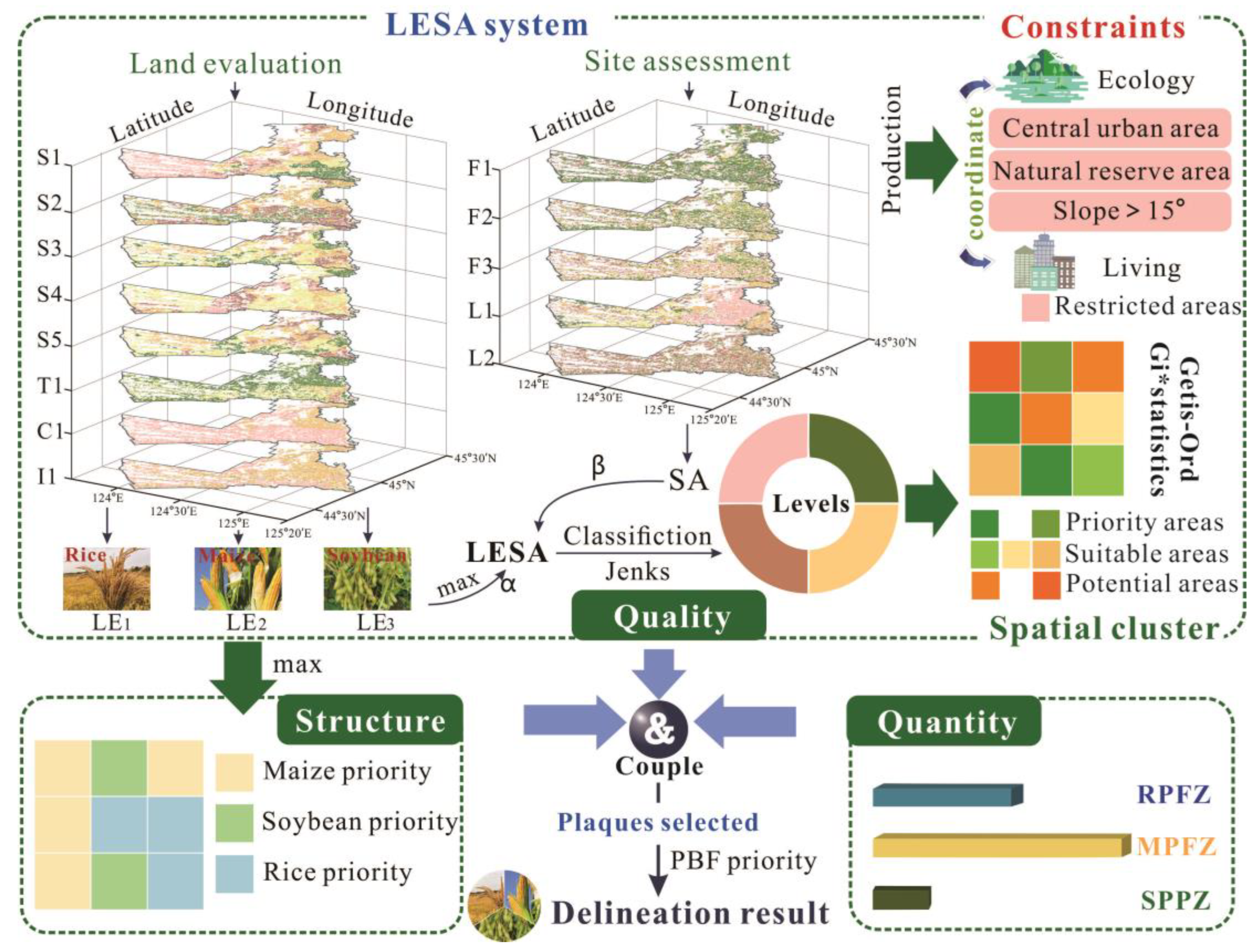
According to the trinity connotation of the two zones policy, this paper developed a technical framework for demarcation that couples the three dimensions of quantity, quality, and planting structure. This trinity takes the comprehensive quality of CL as the delineation potential, the quantity target as the guidance, and the planting advantage of the plot as the basis for positioning the specific use of CL. There are three procedures (Figure 2) to identify the two zones.
Step 1. The land evaluation and site assessment (LESA) method is conceived and developed with two main themes in mind: the planting quality of a specific crop and the overall quality. The planting quality is used to guide the planting type of the assigned plot; the overall quality, as the result of the CL quality evaluation, is the basis for identifying the potential of the plot to be divided into two areas. After establishing the LESA system, each parcel’s land evaluation (LE), site assessment (SA), and LESA values are calculated.
Step 2. Using Getis–Ord Gi* statistics, the high-quality concentrated areas of CL are identified. The spatial aggregation aspects of comprehensive quality (the LESA scores) are assessed. On this basis, they are divided into the three categories of priority areas, suitable areas, and potential areas. Furthermore, CL that is restricted because of constraint circumstances is identified and labeled as restricted regions.
Step 3. Patches are selected and delineated into two zones in the order of the priority area, suitable area, and potential area under the guidance of quantity targets. Additionally, planting types are determined under the guidance of planting advantages (the LE results). Furthermore, in the delineation process, the PBF patches are preferentially considered for delineation into two zones. The patches are thoroughly inspected and decided in accordance with the regional pattern outlined in the 13th Five-Year Plan. When the quantity target meets the requirements, the delineation work is completed and the layout result of the two zones is formed.

3.2. Methods

3.2.1. LESA System

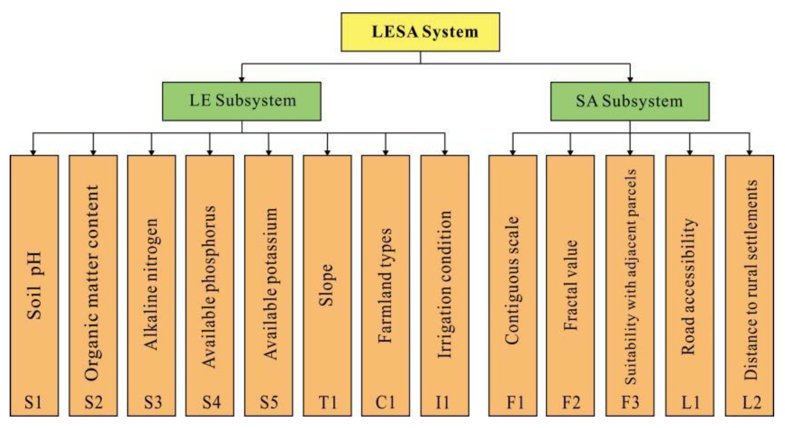
In the LESA system, CL natural circumstances are analyzed by the LE subsystem, while CL compatibility with socioeconomic conditions are determined by the SA subsystem [37,38,39,40,41,42]. However, this paper has created such a setting that the LE subsystem has different quality expression characteristics for different planting types because agricultural planting benefits are regulated by natural background circumstances. However, the SA subsystem is almost independent of different planting types, that is, all planting types prefer a good site environment. Therefore, different from traditional studies, LE guides the quality of specific planting types, including rice (LE1), soybean (LE2), and maize (LE3), to differentiate and customize the specific planting types of CL patterns.
(1) Selection factors
Based on the achievements of farmland classification elements such as “Grading Regulations for Farmland Quality” (GB/T28407-2012) and the research results of domestic and foreign scholars [48,49,50], eight factors were selected to build the LE subsystem and five factors were selected to build the SA subsystem (Figure 3). In the LE subsystem, each factor has a direct value.
To extract the values of the factors, a buffer analysis, the Euclidean distance, and near function tools were applied in ArcGIS (10.4). The contiguous scale was used to evaluate the spatial connectivity of farmland plaques, which were considered to be connected when the distance between them was less than a specified threshold. According to the Standard for the Construction of High Standard Farmland (TD/T 1033-2012) and the General Standard for the Construction of Well-Facilitated Farmland (GBT30600-2014), a 10-m buffer parameter was selected [26]. The indicators without characteristic values were quantified as follows:
C S = S n
where S is the farmland continuous area and n is the number of parcels in the continuous area.
The fractal value can be characterized by the dividing dimension in landscape ecology; a greater value shows that the shape rules are convenient for cultivation.
F = 4 × A P
where F is the fractal value of a certain unit j, P is the length, and A is the area.
Suitability with adjacent parcels refers to suitability with bordering land. The stability of a farmland parcel is weak when it is surrounded by other types of land.
T = Y / P
where Y refers to the length of the common side with adjacent CL.
Both road accessibility and the distance to rural settlements are indicators that are positively correlated with the convenience of cultivation. The formulas are as follows.
R C = a n
where a is the number of roads that cross the pattern spots in each continuous area.
D R C = M 1 r , r = d s d , d = S R c π
SR is the regional area, c is the number of settlements, and d is the function radius of the location factor. ds refers to the distance from the parcel to the settlements, r refers to the relative distance, and M refers to the scale index, which takes a value of 100.
(2) Weight assignment
The main advantage of analytic hierarchy process (AHP) lies in its impartial and logical classification system and the flexibility to integrate various assessment factors [51,52,53,54,55]. This study used it to calculate the weight value of each index of the LE and SA subsystems. The values were determined by MATLAB (R2018a, MathWorks) after creating table matrices and checking the consistency ratio [51,52,54]. The relative importance of each indicator was extensively collected through the existing research and thus comprehensively evaluated. The weight values of LE and SA subsystems were evaluated, with the CR values of 0.0185 and 0.0472, respectively, less than 0.1. The consistency was passed.
(3) Indicator scoring
The standard score function (SSF) was used for transformation and normalized to a value from 0–1 based on different SSFs [49]. There are four types of subordinate function relationships, namely parabolic function (SSF1), S-curve function (SSF2), anti-S-curve function (SSF3), and ladder-type accurate function (SSF4). The functions were calculated as follows and the methods and thresholds are summarized in Table 1 [56,57,58,59,60,61,62,63].
SSF 1 : f ( x ) = 0.1 , x a 1 0.1 + 0.9 × ( a 1 a 2 ) ( a 2 a 1 ) , a 1 < x < a 2 1.0 , x a 2
SSF 2 : f ( x ) = 1.0 , x a 1 0.1 + 0.9 × ( a 2 x ) ( a 2 a 1 ) , a 1 < x < a 2 0.1 , x a 2
SSF 3 : f ( x ) = 0.1 , x a 1 , x a 4 0.1 + 0.9 × ( x a 1 ) ( a 2 a 1 ) , a 1 < x < a 2 1.0 , a 2 x a 3 0.1 + 0.9 × ( a 4 x ) ( a 4 a 3 ) , a 3 < x < a 4
SSF 4 : f ( x ) = 1.0 , x = a 1 0.7 , x = a 2 0.4 , x = a 3 0.1 , x = a 4
where f(x) is the score of indicators, x is the measured value of the indicators, and ai is the threshold value of the indicators.
For the other factors, the values calculated by the formulas represent their quality, with a positive correlation. The extreme value method was used for standardization with a value from 0–1.
f ( x ) = x i x m i n x m a x x m i n
where xmin is the minimum value of the indicator and xi is the maximum value of the indicator.
(4) Score value
The quality scores of LE and SA were obtained by a weighted summation of the factors. A flexible weight was added to LE and SA to obtain the total value of the units so that the maximum score was 1. To allow the results to better guide a two-zone delimitation, the weight value was determined to be 2:3. The highest score of LE was temporarily selected for inclusion in the calculation of the total LESA score, since planting zones should be based on suitability.
L E i = j = 1 n ( f j × w j ) , ( i = 1,2 , 3 )
S A = j = 1 n f j × w j
L E S A = α L E + β S A
where L E i is the land evaluation score for planting rice, soybeans, or maize; SA is the score of the site assessment; f j and w j are the evaluation scores and weights of the factor for each parcel, respectively. LESA refers to the comprehensive evaluation score and α and β are the weights of the index.
(5) Quality class
The suitable order was divided based on Jenks natural breaks classification, which aims to reduce intraclass variance and maximize interclass variance and is a widely used data clustering method [64]. The quality order was divided into four classes, specifically highest, high, medium, and low quality.

3.2.2. Getis–Ord Gi*Statistics

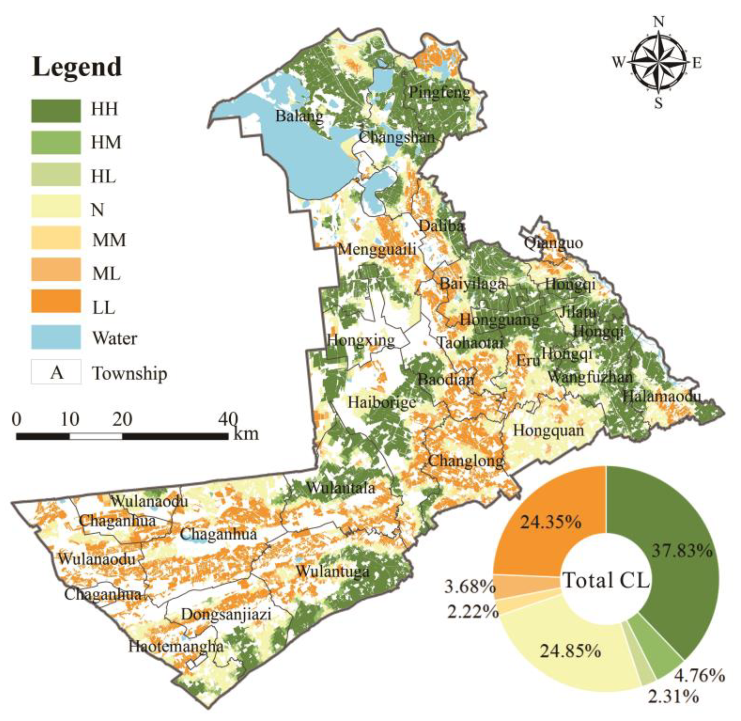
To analyze the spatial cluster of CL quality, Getis–Ord Gi*statistics were used [65,66]. The distribution pattern of the “hot spot” and “cold spot” LESA scores was obtained. The results were classified into the following seven categories according to Z scores: HH, HM, HL, MM, N, ML, and LL.
G i * = j = 1 n w i j x j X ¯ j = 1 n w i j S n j = 1 n w i j 2 j = 1 n w i j 2 / n 1
X ¯ = 1 n j = 1 n x i
S = 1 n j = 1 n x j 2 X ¯ 2
where G i * is the Z score, x j is the LESA score, w i j is the spatial weight, n is the number of parcels, X is the mean value, and S is the standard deviation. As for the seven types, the meanings are: HH is adjacent to each other of the high-quality areas of CL; HM is that the high-quality area is adjacent to the median-quality area of CL; HL is that the high-quality area is adjacent to the low-quality area of CL; MM is adjacent to each other of the median-quality areas of CL quality; N is no significant clustering of CL mass distribution; ML is that the median-quality area is adjacent to the low-quality area of CL; LL is adjacent to each other of the low-quality areas of CL.

3.2.3. Constraint Conditions

To prevent soil erosion, it is forbidden to divide CL with a slope larger than 15° into two zones according to the Law of the People’s Republic of China on Water and Soil Conservation and the Guidance on the Establishment of the Grain Production Functional Zone and the Important Agricultural Product Production–Protection Zone (short in Guide). In addition, CL situated inside the border of a central urban area or a nature reserve is considered to be a constraint condition for enhancing the coordination among the production space, construction space, and ecological space.

4. Case of Qianguo County

4.1. Case Area

A case study of the Mongolian Autonomous County of Qian Gorlos (hereinafter referred to as Qianguo County) was performed to discuss the delineation and layout of the two zones to verify the scientific feasibility of the framework and to offer a reference for two-zone delineation in northeast China and the entire country. As shown in Figure 4, Qianguo County is located between 44°17′ and 45°28′ N latitude and 123°18′ and 125°35′ E longitude on Songnen Plain, Jilin Province. Its unique location is not only in the Jilin section of the widely defined black soil region in northeast China but also in the Jilin golden corn belt, one of the three golden corn belts in the world. The site covers an area of 5904.09 km2 and is mainly composed of CL, grassland, forestland, and water, which account for 87.79% of the total area; it is a typical agricultural county. Furthermore, unlike other counties in northeast China that merely disperse irrigated land (IL), Qianguo County is one of the four key irrigation zones in northeast China, with a flat topography and abundant surface runoff resources (such as the Songhua River, the Nen River, and Chagan Lake). As a result, Qianguo County offers a representative example to discuss how to effectively safeguard CL and precisely coordinate planting patterns, that is, how to delineate two zones appropriately.
According to data from the 2017 Land Use Change Survey, the current CL scale is over 3224.66 km2, with permanent basic farming accounting for 71.60% of the total land. According to the geographical distribution (Figure 4), rainfed land is widespread, paddy land (PL) is primarily distributed in the eastern part of the county, and IL is scarcely distributed. Furthermore, according to the Implementation of the Establishment of Two Zones (Jilin Provincial People’s Government, 2017), a RPFZ comprising 726.47 km2, a MPFZ comprising 1686.67 km2, and a SPPZ comprising 140.00 km2 are considered to be in the delimitation of two zones in Qianguo County.

4.2. Data Sources and Processing

Land use data, spatial planning data, natural geographic data, and economic and social data are the data used in this study. Raster datasets are resampled to a 10-m resolution and all datasets are projected to the CGCS 2000 3 Degree GK _CM 123E coordinate system. The multisource data applied in this paper are mainly obtained in the following ways: the land use data are from the second national land survey database of the Qianguo County Land Use Change Survey Data in 2017 and the PBF data are from the Results of the Demarcation of Permanent Basic Farmland in Qianguo County in 2017. The regional spatial planning data are from Qianguo County Land Use Master Plan adjustment and improvement data (2017). The terrain data are from the Geospatial Data Cloud (https://www.gscloud.cn/ (accessed on 12 June 2020)). In addition, the soil data and irrigation condition data are obtained from the detailed soil survey and irrigation well survey. A total of 3695 effective soil sample points are collected and all 8857 irrigation wells are recorded.

4.3. Results of the Delineation

4.3.1. LESA System

It is different from traditional research, as the LE results vary among different crop types. In general, regardless of the crop type, the LE mainly focuses on high quality and medium quality (Table 2). The distribution of the highest quality CL in LE1, LE2, and LE3 has obvious spatial differentiation, which is mainly distributed in the northeast and eastern central parts of the county and accounts for 16.37%, 20.92%, and 23.67% of the total CL, respectively. This spatial differentiation provides good conditions for guiding regional planting planning. In addition, the SA results imply human influence on agricultural utilization and demonstrate excellent site characteristics in Qianguo County. The CL with the highest quality or high quality, which is widely dispersed, accounts for 85.41% of the total.
The CL evaluation findings are obtained by using the LESA score calculation method. The LESA values vary from 0.33 to 0.96, with an average of 0.72, as shown in Figure 5. Furthermore, the LESA findings show that the overall quality of CL in Qianguo County is at the highest and high levels, which account for 46.50% and 38.91% of the total agricultural area, respectively, and it is widely distributed throughout the county, with a small concentration in the county’s eastern and central areas, such as Wangfuzhan, Balang, and Halamaodu. In contrast, medium- and poor-quality CL can be found in the county’s western and central districts, including Chaganhua, Wulanaodu, and Changlong.

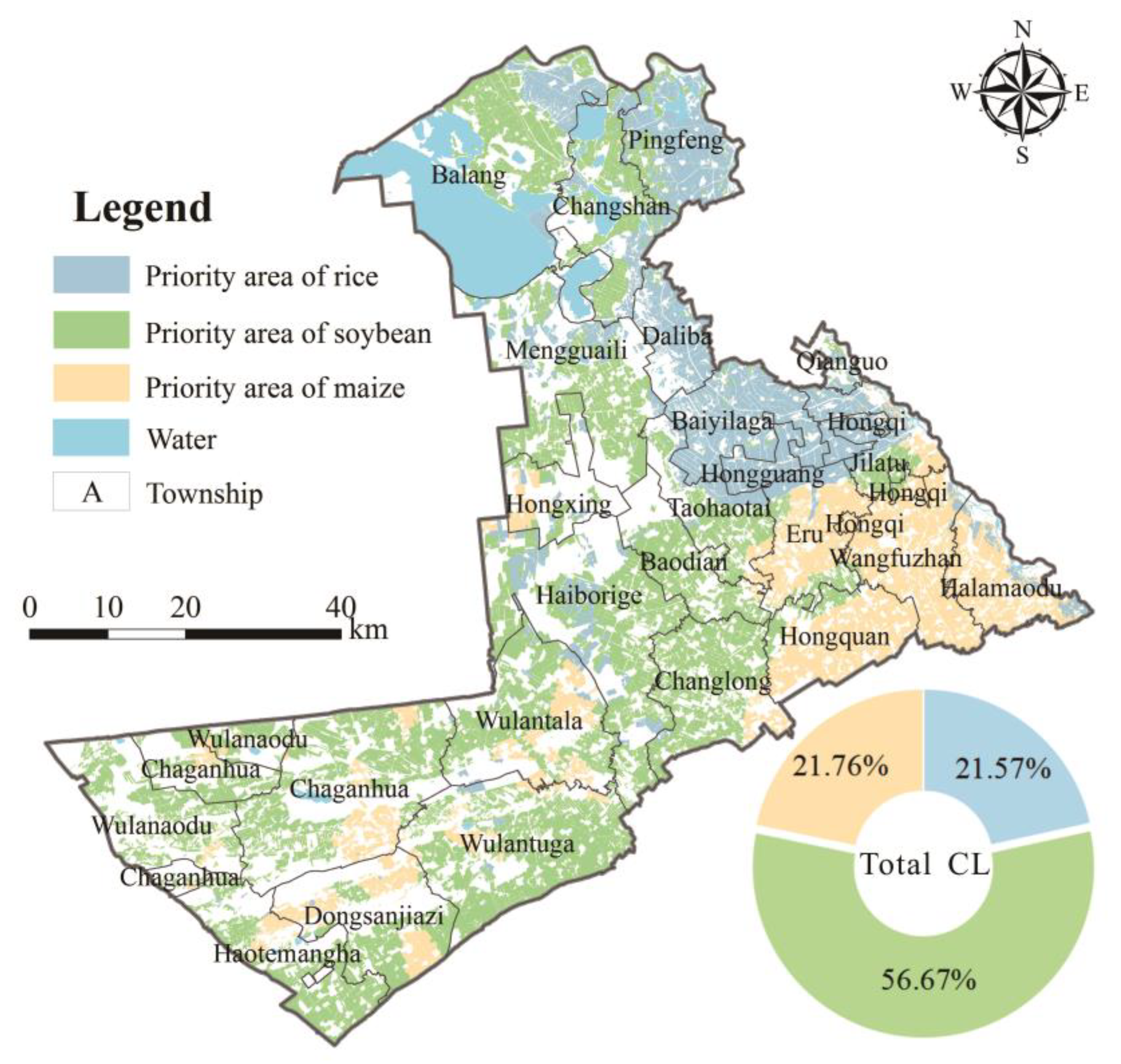
4.3.2. Cultivation Priority Planning Results

Cultivation priority is assigned to the crop type with the highest LE score for each CL plaque, which refers to the planting benefits and considers the natural background circumstances, which can inform planting plans in conjunction with policy guidance (Figure 6). In general, the northeast of the county is the dominant rice planting area, the east is the dominant maize planting area, the central part is the dominant soybean planting area, and the west has a staggered distribution of the dominant maize and soybean planting areas. The dominant areas for rice, soybeans, and maize account for 21.57%, 56.67%, and 21.76% of the total CL, respectively. In addition, the most important elements in determining cultivation priority areas are the farmland type and the soil pH. The wide distribution of PL in the northeast is mainly because the area is used primarily for rice planting. The CL plaques found in the central and western parts of the county with high soil pH are ideal for growing soybeans because soybeans are more alkali-tolerant than rice and maize.

4.4. Regional Division of the Potential Types

As shown in Figure 7, the Getis–Ord Gi* statistics reveal the spatial cluster characters of CL quality, with HH, LL, and N being the most widely dispersed. HH-type CL accounts for 37.83% of the total, with clusters and distributions in the northeast and in sections of the central county. LL-type CL is also widespread, accounting for 24.35%. N-type CL is largely found in Hongquan, accounting for 24.85%, and scattered outwards surrounding the HH and LL regions.
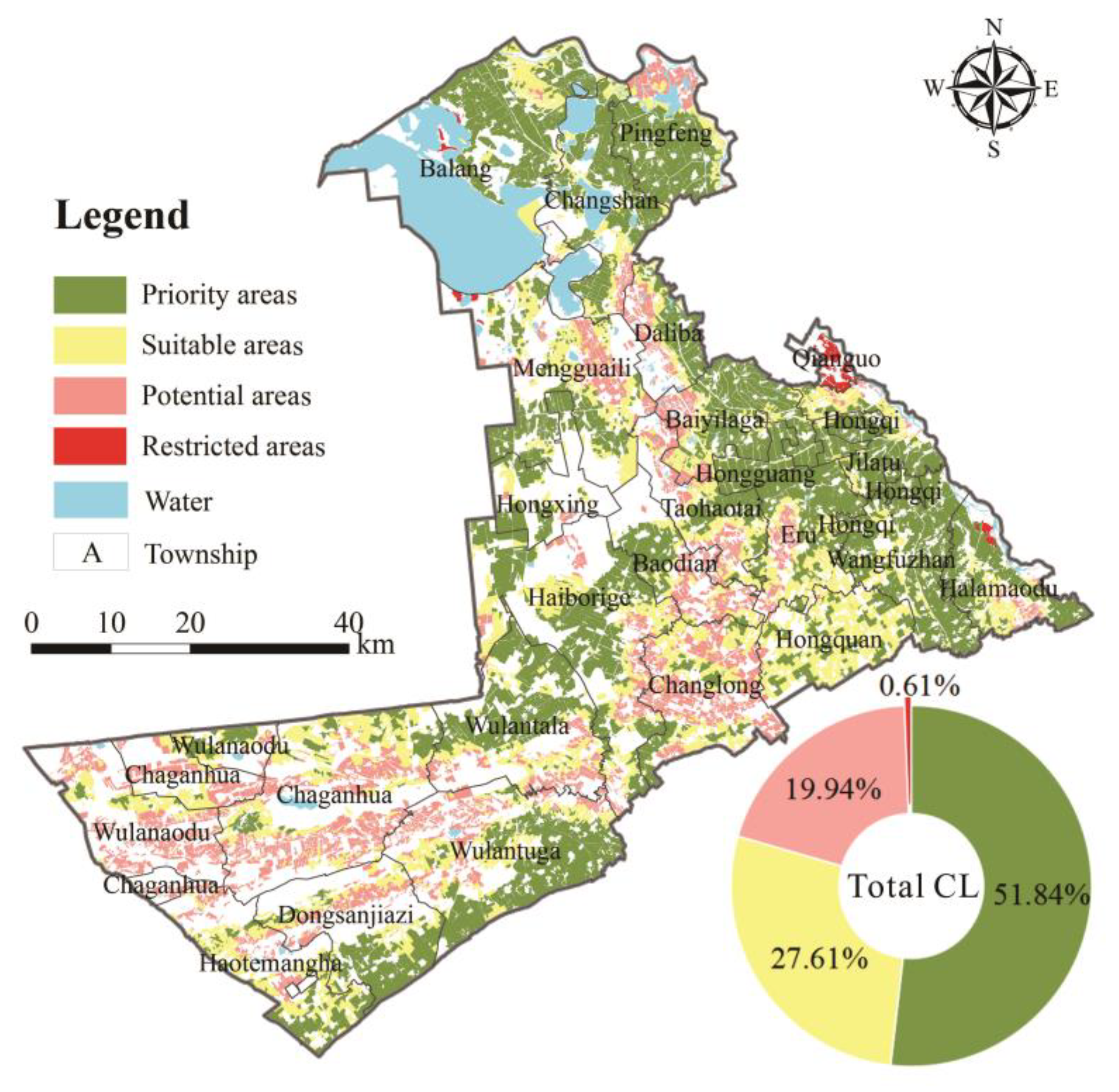
The priority area, suitable area, potential area, and restricted area are delineated after identifying the spatial clustering characteristics and screening the patches according to the constraints (Figure 8). The priority area has the highest potential for two-zone demarcation with minor limiting factors; it accounts for 51.84% of the county. It is typically found in the county’s eastern and central areas. Due to the excellent quality and spatial clustering of high-grade CL, the priority area is ideal for two-zone delimitation to ensure its suitability for agricultural use. The suitable area, which accounts for 27.61% of the overall area, extends outwards from the priority area. It is planned as the key supplementary region of the two zones to ensure the quantity of grain and agricultural products. The potential area (19.94%) is concentrated in the county’s central and western regions, which makes farmland exploitation difficult; these areas can be demarcated into two zones after completing agricultural consolidation to fill the quantity gap in the two-zone delimitation. Only 0.61% of CL with instability in nature reserves or central towns are classified as restricted areas. The delimitation of this CL area into two zones should be avoided; the area should be set aside for ecological de-farming or construction land conversion, which might help meet construction land or ecological land quotas in general land-use planning and alleviate land pressure.

4.5. Two Zone Delineation Results

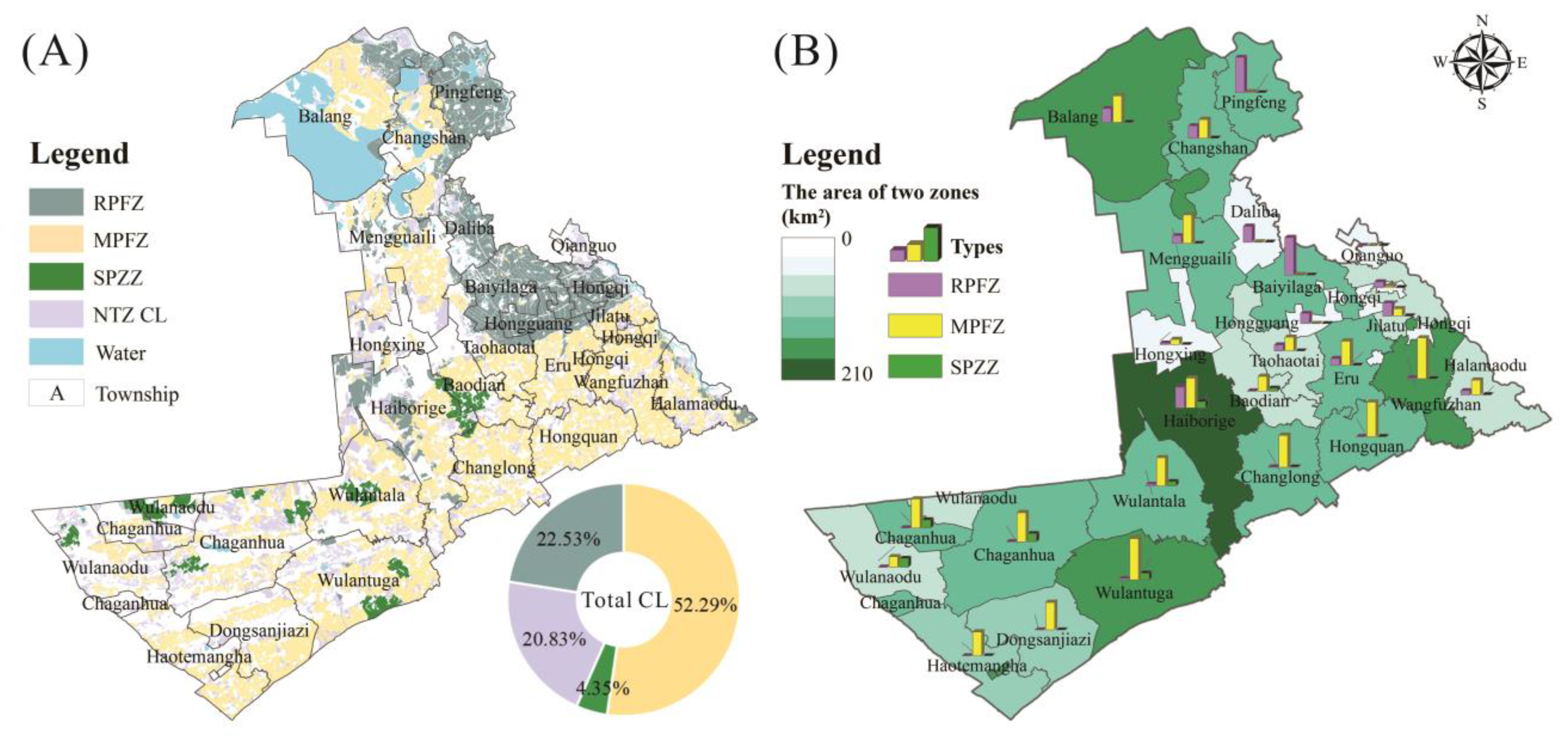
Based on the results of the potential area delineation, guided by quantitative objectives and coupled with the results of planting planning and evaluation, priority is given to PBF patches and CL plaques are screened and customized. Finally, 79.17% of the total CL is delineated into two zones. As shown in Figure 9, the RPFZ is mostly dispersed in towns inside the Qianguo irrigation region, such as Pingfeng, Baiyilaga, Balang, and Daliba, and accounts for 22.53% of the total CL. Furthermore, the RPFZ is also scattered in Haiborige, which is located in the county’s central region. The MPFZ is extensively dispersed, which accounts for 52.29% of CL, and can be found in all towns except Qianguo and Hongguang. It is more concentrated in the eastern parts of the county, such as Wangfuzhan, Hongquan, and Changlong. In accordance with the advice in the Plan for formation around the agricultural demonstration area in the southwestern area, the SPZZ is located in the southwest, which accounts for 4.35% of the total CL, and it is concentrated in Wulantuga, Wulantala, Wulanaodu, Haiborige, and Chaganhua.
Figure 10 illustrates the final delimitation of CL and the composition of the two zones. The priority and suitable areas comprise the majority of the region divided into two zones. The RPFZ, MPFZ, and SPZZ have potential areas of 4.04%, 9.81%, and 14.73%, respectively. This portion of the potential CL area, which is divided into two zones, is mostly situated in the central and western regions. Meanwhile, more emphasis should be placed on enhancing the overall CL quality. Figure 10 also well exposes the problem of the current demarcation of PBF in Qianguo County. The MPFZ and SPZZ are completely composed of PBF, whereas a significant portion of the RPFZ comprises non-basic farmland because of a lack of PL-type basic farmland. In addition, due to the characteristics of non-basic farmland, a certain amount of CL in the priority areas is not delimited into the two zones, with not only good soil quality but also stable site conditions; this part is replaced by CL in the potential areas with the attribute of PBF. To some extent, this exposes the quality problem of the current PBF and that the delimitation of basic farmland is demarcated mainly based on administration considerations rather than on a scientific evaluation method. As a consequence, there is a discrepancy between the existing basic farmland layout and the CL quality analysis; improvements and adjustments are needed.

5. Discussion

5.1. CL Protection Systems in Developed and Developing Countries

The aims and implications of CL protection strategies in developed and developing nations change because of various levels of development. Generally, developed countries have attained high-quality industrialization and urbanization, which has resulted in CL protection policy aims that protect traditional agricultural landscapes and the ecological environment. The evidence comes from widely used farmland protection frameworks such as the UN Food and Agriculture Organization’s FESLM framework, Europe’s SOSTARE model and HVNF framework, and France’s IDEA framework. Their primary components are preserving environmental quality and agricultural landscapes [67,68,69]. Because developing countries are still in the process of industrialization and urbanization, their CL protection policies are primarily concerned with maintaining the growing population in this process, that is, addressing the problems of hunger and poverty. As a result, developing countries’ CL protection policies concentrate on maintaining food security by protecting the quality and quantity of CL. This is especially evident for China, the world’s largest developing country with the most people. China’s central government has enacted a series of policies aimed at protecting CL. Some academics have assessed the effectiveness of China’s CL preservation efforts by using statistical and spatially explicit approaches. Many academics agree that CL protection policies are critical for controlling urban sprawl and CL loss [70]. Furthermore, as a rare country in which ownership is public, China has displayed various land management processes and driving forces that are distinct from those seen in other countries with private land ownership. Sequential mechanisms for farmland preservation are available in private land ownership nations, which range from legislation, legal determinations, and taxes to acquisition pathways. Programs on the purchase of development rights (PDR), clustering, and transfer of development rights (TDR) are among the most widely applied approaches [71]. However, the most distinctive characteristic of socialist public land ownership is that policy planning by the government is a powerful driving force that has an absolute leadership position in the CL protection system. The state can reasonably regulate the degree of development and usage and timely alter the connotation and core aims of CL protection measures according to the development demands of different eras.
Regarding whether the CL protection framework proposed in this paper can become a Chinese model for global CL protection, it would not be referenced by all the countries among the world because there is no doubt that the CL protection model of each country is determined by its own development level and core objectives. However, it is considered as a useful tool for some countries that are experiencing a similar stage of development as China. Because this zoning model not only considers the quantity and quality protection of CL but also introduces the concept of supply and demand of grain and land suitability, it can ensure the food security of these countries more effectively through more effective cultivated land protection.

5.2. Linkage between CL Protection and the Grain Security System

Although the CL protection system with PBF and the dynamic balance system of CL as the core has effectively restrained the loss of CL, a considerable number of researchers believe that the CL protection policy is not the most effective means to achieve China’s food security goals [18,72]. Many recent studies suggest that CL protection policies have damaged CL quality protection [4,18]. Many studies show that the loss of CL is concentrated in China’s agricultural districts with the highest output but that reclamation efforts are common in the western and border provinces with low productivity [73,74]. To accomplish grain security, CL protection policies must be linked to the grain security system [75].
A brief review of the development of China’s food security system reveals that since the 1990s, the Chinese government has successively established the national special grain reserve system (1990), the protective price system and the grain risk fund system (1993), the system of state ordering, market purchasing, and the provincial governor’s responsibility system for balancing grain supply and demand (1995), and the system of building large commodity grain bases (2006) and has gradually built a food security system with a stable supply, strong regulations, and efficient operation [12,76,77]. Although China’s agricultural production efficiency and grain output have increased consistently since the implementation of the food security system, the Chinese government has gradually warned about new food security risks, such as the phenomenon of national grain entering bases and foreign grain entering the market, which are thought to pose hidden threats to China’s sovereignty and food security as the international situation tightens [8,78]. Adhering to the CL red line and achieving basic grain self-sufficiency and absolute grain safety have evolved into new national food security strategies, which merge the two major systems of CL protection and grain security.
Given the above review of the CL protection policies and grain security systems, it can be concluded that the communication between the two systems has been weak since the 1990s [79,80]. They appear to function in “parallel lines” that are focused on the grain security system and CL protection, which leads to a lack of effective matching among land resource preservation, usage, allocation, and grain security. At first, the main terms in the CL protection system were CL quantity, CL quality, CL pressure, land remediation, soil restoration, etc., whereas the key words in the food security system were food quantity, food consumption, food supply, food quality, etc. However, after decades of development, these two systems have gradually evolved into a tightly integrated whole framework, with sustainable agriculture as the core phrase. The 13th Five-Year Plan, in particular, expanded their communication, with the strategy of storing grain on land brought to the public’s notice. For example, the National Agricultural Adjustment Plan for Planting Industry, the National Agricultural Sustainable Development Plan, and the implementation of the two zones policy were released. From a certain point of view, the two zones policy seems to be a link that connects the two systems of CL protection and grain security. The original purpose of this policy was to employ CL resources in a scientific and reasonable manner, increase its multidimensional production capacity, and allow certain CL to recuperate and build up strength. Simultaneously, agricultural planting structures would be adjusted and optimized to ensure a safe, stable, and sustainable food supply, which would reduce the burden of food reserves and relieve the pressure on the international market [81,82]

5.3. From County to Country

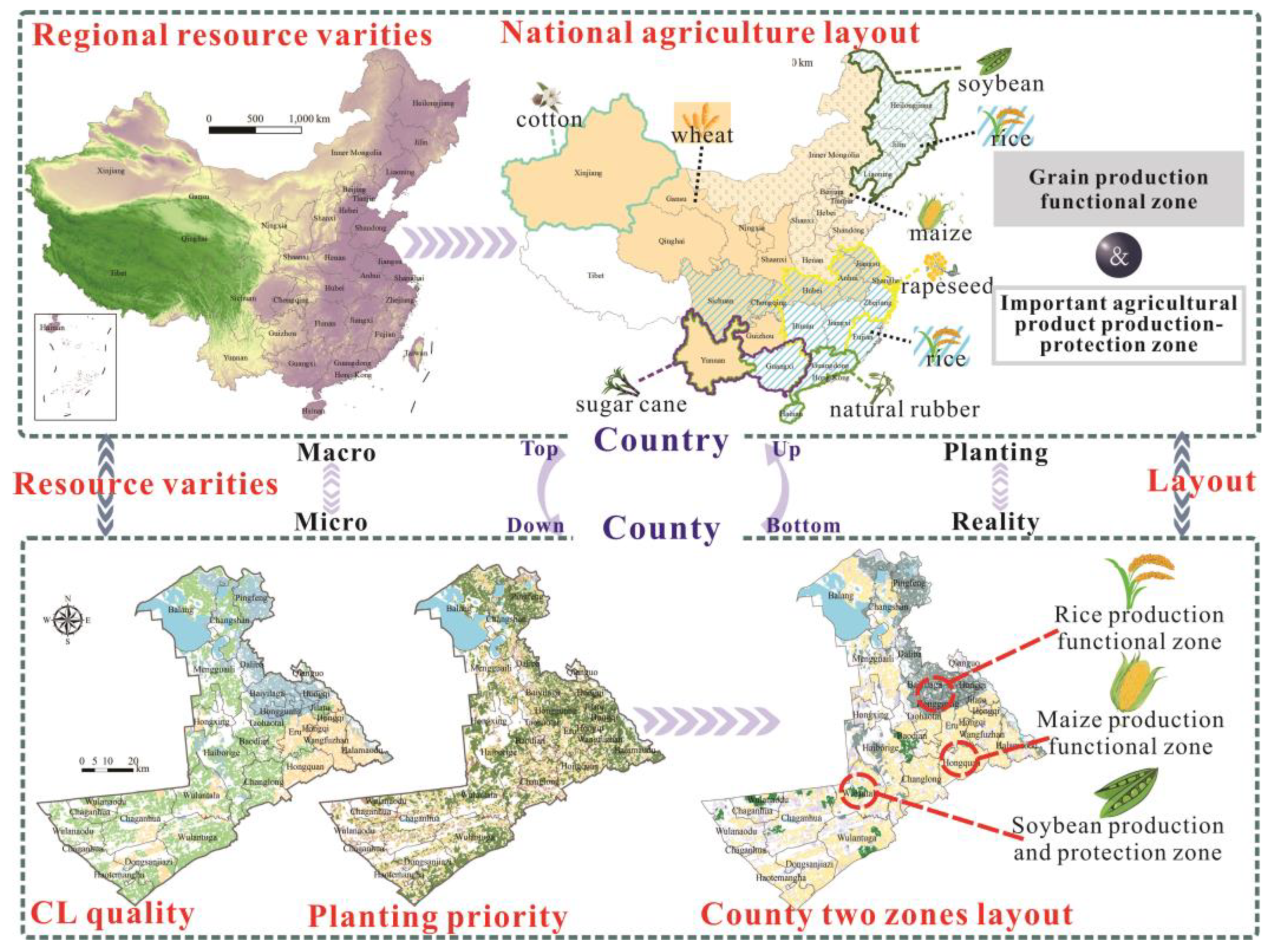
As explained previously, in China, government policy guidance utterly dominates land management and reform. The implementation of the two zone CL protection policy, which combines the connotation of optimal land resource allocation, can be divided into two directions: top-down (from country to county) and bottom-up (from county to country) (Figure 11). The top-down approach focuses on the entire situation and generates a series of optimal solutions by taking the global objectives into account. The bottom-up approach makes decisions at the micro scale to emphasize the detailed expression of localized elements [83].
In terms of the two zones policy, “top” refers to the national plan for the spatial construction of China’s agricultural layout and the macro structural reform of the agricultural supply. Based on China’s enormous area and considerable regional variations in natural resources, the release of this policy outlines the appropriate allocation of CL utilization from the standpoint of regional resource utilization potential and conflict. A grain production pattern has been built for the three major grain crops of rice, wheat, and maize. Rice production and supply are primarily concentrated in the eastern region, including the Northeast Plain, the Yangtze River Basin, and SE China. Wheat production and supply are primarily concentrated in the central and western regions. Maize production and supply are primarily concentrated in the northeast and some central regions. Furthermore, the five major planned agricultural products of soybean, cotton, rapeseed, sugar cane, and natural rubber will be concentrated in NE China, Xinjiang Province, the Yangtze River Basin, the southwestern region, and the southern region to form regionally distinctive agricultural products with geographical indications and to maximize the potential of regional agricultural resources. However, achieving this great goal requires precision and effective implementation, i.e., the transition from macro policy to micro reality. As a result, supervising each CL plaque at the county level not only is in line with the current requirements of thorough and precise administration and control but also is a crucial necessity for the rational reconstruction of the national agricultural layout. This paper offers a two zones delineation framework that combines quantity, quality, and structure from the standpoint of the micro spatial layout, which can serve as a reference to coordinate the interaction between macro aims and micro implementation. In terms of regions and countries, the rational arrangement of each micro space forms the overall scenario upwards, which may accomplish the complete benefits of land resource allocation.

5.4. Contributions and Limitations

With regard to the ambiguous understanding of the two zones policy, this study explores how the two zones policy was conceived and what mechanism it uses to make up for the deficiencies of the previous policy through a comprehensive review of the evolution of China’s CL protection policy. Then, a delineation framework is proposed integrating quantity targets, quality conditions, and planting design to achieve the trinity of quantity, quality, and planting structure. On this basis, different environments are coordinated and the limiting conditions are set by considering the coordination with living space and ecological space. Furthermore, the framework is determined to further enhance CL protection based on PBF. As a result, the suggested delineation process is entirely based on the two zones’ primary functions and it has practical guiding relevance to attain detailed and reasonable land use and effective land management.
Furthermore, by using the LESA model’s flexibility, this paper develops two themes, including planting planning and comprehensive quality evaluation [48,51,52], which not only integrate but also simplify the evaluation process. The indicators used contain the typical soil variables, topographical features, other common factors in the LE system, and irrigation conditions. Irrigation conditions are included in the LE subsystem since greater consideration is given to the varying restrictions on different crops. Furthermore, the continuous scale chosen does not belong to the traditional factor in the LESA system but is an element that has recently been widely implemented in the SA subsystem to determine whether the CL is centralized and contiguous to adapt to and promote agricultural modernization management [60].
This research, however, still has room for improvement. As mentioned above, certain developed countries’ CL protection emphasizes ecological quality. Given the shifting emphasis in China from economic growth to ecological civilization construction, a mono-productive function quality fails to meet the multiple demands placed on CL’s adaptive ability and resilience such as continued urban expansion and development. Ecological function has gradually become another quality that has attracted the attention of policymakers and academics [17,57,58]. Geochemical characteristics are widely used in this regard to evaluate CL ecological quality or to expose the internal mechanism of CL quality change. However, because of data collection limitations, this work does not offer indices of CL ecological quality. Incorporating into this framework indicators such as farmland pollution by heavy metals can further strengthen its scientific value and such an evaluation system can better match the regions affected by industry and urbanization.

6. Conclusions

In recent years, China’s resource and environmental limitations have become increasingly apparent. Furthermore, the tighter international trade situation has raised the possibility of food production instability in China because of major climatic occurrences and worldwide public health crises. The Chinese are conscious that adjusting the agricultural layout and optimizing the planting structure are realistic ways to improve the productive potential of CL resources in the contexts of coordinated urban and rural development and coordinated economic development and environmental protection. The CL protection strategy was issued in this respect, along with the connotation of planting structure optimization based on quantity and quality protection, and the two zones policy was implemented. This paper investigates the evolution of China’s CL protection strategy during the previous 30 years and the growth of the two zones policy. Next, a framework for delineation is proposed and a case study is utilized to discuss the approach from macro objectives to micro precision management. The primary conclusions are as follows.
(1) Driven by the complex external and international situation and domestic development goals, China’s CL protection policy has gradually realized the transition from a period with a single dimension that focused on quantity to a period of dual dimension coordination with an emphasis on quantity and quality and, then, to a period of a balance among the trinity and optimization of quantity, quality, and planting structure. The emphasis on CL protection has increasingly switched from guaranteeing that the quantity of CL does not decline to giving attention to the comprehensive output capability under complex situations. The two zones policy is based on quantity control, quality protection, and planting planning, with the fundamental goal of forming a CL protection area with both basic security and anti-interference capabilities, which is consistent with the strategy of storing grain on land.
(2) A technological framework for combining the three dimensions of quantity, quality, and planting structure is proposed. The LESA framework is modified and used to consider two themes: the crop planting priority and CL quality. The hot spot analysis method then identifies the high-quality concentrated space, with the living space and ecological protection space as restrictions, which assesses the potential of delineating the two zones. The CL protection space is then demarcated based on the quantity objective and the specific usage of CL is customized according to the planting advantages. Accordingly, this research provides concepts and technological references for translating macro goals into regional micro layout and administration.
(3) The case of Qianguo County demonstrates that the CL quality is excellent and that the suitability for different crops has evident spatial differentiation characteristics. Finally, 79.17% of the CL was separated into two zones to establish the spatial pattern of the RPFZ in the northeast, the MPFZ across the county, and the SPZZ scattered sparsely in the south. The actual case validates the viability of the proposed framework and provides a practical reference for how to carry out efficient CL preservation, meticulous management, and the rational optimal allocation of agricultural resources at the county level.

Author Contributions

Conceptualization, methodology, writing—original draft, and writing—review and editing, S.W.; validation, supervision and funding acquisition, D.W.; formal analysis, software and visualization, S.W. All authors have read and agreed to the published version of the manuscript.

Funding

This research work was funded by the National Natural Science Foundation of China (grant number: 42071255).

Institutional Review Board Statement

No applicable.

Informed Consent Statement

No applicable.

Data Availability Statement

No applicable.

Acknowledgments

This research work was financed by the National Natural Science Foundation of China (No. 42071255).

Conflicts of Interest

The authors declare that they have no known competing financial interests or personal relationships that could have appeared to influence the work reported in this paper.

Abbreviations

CL—cultivated land; PBF—permanent basic farmland; LESA—land evaluation and site assessment; LE—land evaluation; SA—site assessment; RPFZ—rice production functional zone; MPFZ—maize production functional zone; SPZZ—soybean production and protection zone; SSF—standard score function; NPBF—non-permanent basic farmland; NTZ—non-two zones

References

  1. Gao, L.; Bryan, B.A. Finding pathways to national-scale land-sector sustainability. Nature 2017, 544, 217–222. [Google Scholar] [CrossRef]
  2. Ministry of Natural of the People’s Republic of China. Press Conference on The Results of The National Cultivated Land Reserve Resources Survey [N/OL]. Available online: http://www.mnr.gov.cn/dt/zb/2016/gd/ (accessed on 28 December 2016).
  3. Zhu, D.; Chen, W.; Qu, X.; Zheng, Y.; Bi, J.; Kan, H.; Luo, Y.; Ying, G.; Zeng, E.Y.; Zhao, F.; et al. Future research needs for environmental science in China. Geogr. Sustain. 2021, 2, 234–242. [Google Scholar] [CrossRef]
  4. Cheng, L.; Jiang, P.; Chen, W.; Li, M.; Wang, L.; Gong, Y.; Pian, Y.; Xia, N.; Duan, Y.; Huang, Q. Farmland protection policies and rapid urbanization in China: A case study for changzhou city. Land Use Policy 2015, 48, 552–566. [Google Scholar]
  5. Bhopal, A.; Blanchard, K.; Weber, R.; Murray, V. Disasters and food security: The impact on health. Int. J. Disaster Risk Reduct. 2018, 33, 1–4. [Google Scholar] [CrossRef]
  6. Klomp, J.; Hoogezand, B. Natural disasters and agricultural protection: A panel data analysis. World Dev. 2018, 104, 404–417. [Google Scholar] [CrossRef]
  7. Pu, M.; Zhong, Y. Rising concerns over agricultural production as COVID-19 spreads: Lessons from China. Glob. Food Secur. 2020, 26, 100409. [Google Scholar] [CrossRef]
  8. Oczkowskie, E.; Bandara, Y. Modelling agricultural land use allocation in regional Australia. Aust. J. Agric. Resour. Econ. 2013, 57, 422–440. [Google Scholar] [CrossRef] [Green Version]
  9. Liu, Y.; Li, Y. Revitalize the world’s countryside. Nature 2017, 548, 275–277. [Google Scholar] [CrossRef] [Green Version]
  10. Spyra, M.; Kleemann, J.; Calò, N.C.; Schürmann, A.; Fürst, C. Protection of peri-urban open spaces at the level of regional policy-making: Examples from six European regions. Land Use Policy 2021, 107, 105480. [Google Scholar] [CrossRef]
  11. Gao, C.L.; Wei, H.K. Prediction study on the urbanization trends of China. Mod. Econ. Sci. 2013, 35, 85e90. [Google Scholar]
  12. Long, H.L.; Ge, D.Z.; Zhang, Y.N.; Tu, S.; Qu, Y.; Ma, L. Changing man-land interrelations in China’s farming area under urbanization and its implications for food security. J. Environ. Manag. 2018, 209, 440–451. [Google Scholar] [CrossRef]
  13. Cullingworth, J.B.; Nadin, V. Town and Country Planning in the UK; Psychology Press: New York, NY, USA, 2002. [Google Scholar]
  14. Pahl-Weber, E.; Henckel, D. The Planning System and Planning Terms in Germany: A Glossary; Akademie for Raumforschung Und Landesplanung, Hanover: Worcester, MA, USA, 2008; pp. 121–185. [Google Scholar]
  15. Liu, X.W.; Zhao, C.L.; Song, W. Review of the evolution of cultivated land protection policies in the period following China’s reform and liberalization. Land Use Policy 2017, 67, 660–669. [Google Scholar] [CrossRef]
  16. Zhou, W.B.; Duan, F.Y. Closing crop yield and efficiency gaps for food security and sustainable agriculture. J. Integr. Agric. 2021, 20, 343–348. [Google Scholar] [CrossRef]
  17. Song, W.; Pijanowski, B.C. The effects of China’s cultivated land balance program on potential land productivity at a national scale. Appl. Geogr. 2014, 46, 158–170. [Google Scholar] [CrossRef]
  18. Wu, Y.Z.; Shan, L.P.; Guo, Z.; Peng, Y. Cultivated land protection policies in China facing 2030, Dynamic balance system versus basic farmland zoning. Habitat Int. 2017, 69, 126–138. [Google Scholar] [CrossRef]
  19. Zhao, Y.L. Statistical analysis of the changes of cultivated land resources in the past 10 years. Territ. Nat. Resour. Study 2020, 1, 53–57. [Google Scholar]
  20. Liu, T.; Liu, H.; Qi, Y.J. Construction land expansion and cultivated land protection in urbanizing China: Insights from national land surveys, 1996–2006. Habitat Int. 2015, 46, 13–22. [Google Scholar] [CrossRef]
  21. Yang, S.L.; Wang, H.M.; Tong, J.P.; Bai, Y.; Alatalo, J.M.; Liu, G.; Fang, Z.; Zhang, F. Impacts of environment and human activity on grid-scale land cropping suitability and optimization of planting structure, measured based on the MaxEnt model. Sci. Total Environ. 2022, 836, 155356. [Google Scholar] [CrossRef] [PubMed]
  22. Wu, Y.Z.; Zhang, X.L.; Skitmore, M.; Song, Y.; Hui, E.C.M. Industrial land price and its impact on urban growth: A Chinese case study. Land Use Policy 2014, 36, 199–209. [Google Scholar] [CrossRef] [Green Version]
  23. Cheng, Q.; Jiang, P.; Cai, L.; Shan, J.; Zhang, Y.; Wang, L.; Li, M.; Li, F.; Zhu, A.; Chen, D. Delineation of a permanent basic farmland protection area around a city centre: Case study of Changzhou City, China. Land Use Policy 2017, 60, 73–89. [Google Scholar]
  24. He, J.; Guan, X.; Yu, Y. A Modeling Approach for Farmland Protection Zoning Considering Spatial Heterogeneity: A Case Study of E-Zhou City, China. Sustainability 2016, 8, 1052. [Google Scholar] [CrossRef] [Green Version]
  25. Zhang, R.; Li, J.; Du, Q.; Ren, F. Basic farmland zoning and protection under spatial constraints with a particle swarm optimisation multiobjective decision model: A case study of Yicheng, China. Environ. Plan. B-Plan. Des. 2015, 42, 1098–1123. [Google Scholar] [CrossRef]
  26. Chen, Y.; Yao, M.; Zhao, Q.; Chen, Z.; Jiang, P.; Li, M.; Chen, D. Delineation of a basic farmland protection zone based on spatial connectivity and comprehensive quality evaluation: A case study of Changsha City, China. Land Use Policy 2021, 101, 105145. [Google Scholar] [CrossRef]
  27. Cai, W.; Yan, H.; Shi, Y. Research of the Basic Farmland Delimitation Based on Fuzzy Decision-making Model. In Proceedings of the 5th International Conference on Management of Technology, Taiyuan, China, 20–23 August 2010; pp. 198–203. [Google Scholar]
  28. Kuang, L.; Ye, Y.; Zhao, X.; Guo, X.; Xie, W. Delineation of basic farmland based on the quality and spatial stability: A case study of Yingtan City, China. Environ. Sci. Pollut. Res. 2022, 29, 88737–88750. [Google Scholar] [CrossRef] [PubMed]
  29. Jiang, P.H.; Li, M.C.; Sheng, Y. Spatial regulation design of farmland landscape around cities in China: A case study of Changzhou City. Cities 2020, 97, 102504. [Google Scholar] [CrossRef]
  30. Liu, Y.L.; Liu, L.; Zhu, A.X.; Lao, C.H.; Hu, G.H.; Hu, Y.M. Scenario farmland protection zoning based on production potential: A case study in China. Land Use Policy 2020, 95, 104581. [Google Scholar] [CrossRef]
  31. Sari, F.; Sari, F.K. Multi criteria decision analysis to determine the suitability of agricultural crops for land consolidation areas. Int. J. Eng. Geosci. 2021, 6, 64–73. [Google Scholar] [CrossRef]
  32. Tseganeh, B.; Sehra, P.S.; Sood, A. Land suitability analysis for agricultural crops using GIS and remote sensing techniques. J. Agrometeorol. 2008, 10, 67–71. [Google Scholar]
  33. Song, G.; Zhang, H.M. Cultivated Land Use Layout Adjustment Based on Crop Planting Suitability: A Case Study of Typical Counties in Northeast China. Land 2021, 10, 107. [Google Scholar] [CrossRef]
  34. Li, P.; Shi, K.; Wang, Y.Y.; Kong, D.N.; Liu, T.; Jiao, J.G.; Liu, M.Q.; Li, H.X.; Hu, F. Soil quality assessment of wheat-maize cropping system with different productivities in China: Establishing a minimum data set. Soil Tillage Res. 2019, 190, 31–40. [Google Scholar] [CrossRef]
  35. Seyedmohammadi, J.; Sarmadian, F.; Jafarzadeh, A.A.; Ghorbani, M.A.; Shahbazi, F. Application of SAW, TOPSIS and fuzzy TOPSIS models in cultivation priority planning for maize, rapeseed and soybean crops. Geoderma 2018, 310, 178–190. [Google Scholar] [CrossRef]
  36. Braun, A.B.; Trentin, A.W.D.; Visentin, C.; Thome, A. Proposal for an optimized method for sustainable remediation evaluation and application: Implementation of a multi-criteria process. Environ. Sci. Pollut. Res. 2019, 26, 35996–36006. [Google Scholar] [CrossRef] [PubMed]
  37. Dung, E.J.; Sugumaran, R. Development of an agricultural land evaluation and site assessment (LESA) decision support tool using remote sensing and geographic information system. J. Soil Water Conserv. 2005, 60, 228–235. [Google Scholar]
  38. Hoobler, B.M.; Vance, G.F.; Hamerlinck, J.D.; Munn, L.C.; Hayward, J.A. Applications of land evaluation and site assessment (LESA) and a geographic information system (GIS) in East Park County, Wyoming. J. Soil Water Conserv. 2003, 58, 105–112. [Google Scholar]
  39. Qian, F.; Lal, R.; Wang, Q. Land evaluation and site assessment for the basic farmland protection in Lingyuan County, Northeast China. J. Clean. Prod. 2021, 314, 128097. [Google Scholar] [CrossRef]
  40. Qian, F.K.; Wang, W.W.; Wang, Q.B.; Lal, R. Implementing land evaluation and site assessment (LESA system) in farmland protection: A case-study in northeastern China. Land Degrad. Dev. 2021, 32, 2437–2452. [Google Scholar] [CrossRef]
  41. Steiner, F.; Dunford, R.; Dosdall, N. The Use of the Agricultural Land Evaluation and Site Assessment System in the United-States. Landsc. Urban Plan. 1987, 14, 183–199. [Google Scholar] [CrossRef]
  42. Esmaeili, E.; Shahbazi, F.; Sarmadian, F.; Jafarzadeh, A.A.; Hayati, B. Land capability evaluation using NRCS agricultural land evaluation and site assessment (LESA) system in a semi-arid region of Iran. Environ. Earth Sci. 2021, 80, 1–4. [Google Scholar] [CrossRef]
  43. Nosrati, K.; Collins, A.L. A soil quality index for evaluation of degradation under land use and soil erosion categories in a small mountainous catchment, Iran. J. Mt. Sci. 2019, 16, 2577–2590. [Google Scholar] [CrossRef]
  44. Ying, Z. Collection of Current Policies and Laws of Land Management; Present China Press: Beijing, China, 2004; pp. 25–182. [Google Scholar]
  45. Zhang, M.; Liu, Y.; Wu, J.; Wang, T. Index system of urban resource and environment carrying capacity based on ecological civilization. Environ. Environ. Impact Assess. Rev. 2018, 68, 90–97. [Google Scholar] [CrossRef]
  46. Huang, D.Q.; Jin, H.R.; Zhao, X.S.; Liu, S.H. Factors influencing the conversion of arable land to urban use and policy implications in Beijing, China. Sustainability 2015, 7, 180–194. [Google Scholar] [CrossRef] [Green Version]
  47. Li, X.Y.; Liu, N.J.; You, L.Z.; Ke, X.L.; Liu, H.J.; Huang, M.L.; Waddington, S.R. Patterns of cereal yield growth across China from 1980 to 2010 and their implications for food production and food security. PLoS ONE 2016, 11, e0159061. [Google Scholar] [CrossRef] [PubMed] [Green Version]
  48. Mao, L.X.; Zhao, J.F.; Xu, L.L.; Yan, H.; Li, S.; Li, Y.F. Climatic suitability of spring maize planted in the “sickle bend” area of China and regulation suggestion. J. Appl. Ecol. 2016, 27, 3935–3943. [Google Scholar]
  49. Zhang, Y.; Dong, S.; Gao, Q.; Liu, S.; Zhou, H.; Ganjurjav, H.; Wang, X. Climate change and human activities altered the diversity and composition of soil microbial community in alpine grasslands of the Qinghai-Tibetan Plateau. Sci. Total Environ. 2016, 562, 353–363. [Google Scholar] [CrossRef]
  50. Daniels, T. Using Lesa in a Purchase of Development Rights Program. J. Soil Water Conserv. 1990, 45, 617–621. [Google Scholar]
  51. Akinci, H.; Ozalp, A.Y.; Turgut, B. Agricultural land use suitability analysis using GIS and AHP technique. Comput. Electron. Agric. 2013, 97, 71–82. [Google Scholar] [CrossRef]
  52. Memarbashi, E.; Azadi, H.; Barati, A.A.; Mohajeri, F.; Van Passel, S.; Witlox, F. Land-Use Suitability in Northeast Iran: Application of AHP-GIS Hybrid Model. ISPRS Int. J. Geo-Inf. 2017, 6, 396. [Google Scholar] [CrossRef] [Green Version]
  53. Mokarram, M.; Mirsoleimani, A. Using Fuzzy-AHP and order weight average (OWA) methods for land suitability determination for citrus cultivation in ArcGIS (Case study: Fars province, Iran). Physica A 2018, 508, 506–518. [Google Scholar] [CrossRef]
  54. Aydi, A.; Abichou, T.; Nasr, I.H.; Louati, M.; Zairi, M. Assessment of land suitability for olive mill wastewater disposal site selection by integrating fuzzy logic, AHP, and WLC in a GIS. Environ. Monit. Assess. 2016, 188, 1–3. [Google Scholar] [CrossRef]
  55. Hassan, I.; Javed, M.A.; Asif, M.; Luqman, M.; Ahmad, S.R.; Ahmad, A.; Akhtar, S.; Hussain, B. Weighted Overlay Based Land Suitability Analysis of Agriculture Land in Azad Jammu and Kashmir Using Gis and Ahp. Pak. J. Agric. Sci. 2020, 57, 1509–1519. [Google Scholar]
  56. El Baroudy, A.A.; Ali, A.M.; Mohamed, E.S.; Moghanm, F.S.; Shokr, M.S.; Savin, I.; Poddubsky, A.; Ding, Z.L.; Kheir, A.M.S.; Aldosari, A.A.; et al. Modeling Land Suitability for Rice Crop Using Remote Sensing and Soil Quality Indicators: The Case Study of the Nile Delta. Sustainability 2020, 12, 9653. [Google Scholar] [CrossRef]
  57. He, W.Y.; Yang, S.; Guo, R.; Chen, Y.X.; Zhou, W.H.; Jia, C.J.; Sun, G.J. GIS-Based Evaluation of Soybean Growing Areas Suitability in China. Comput. Comput. Technol. Agric. 2011, 346, 357–366. [Google Scholar]
  58. Kihoro, J.; Bosco, N.J.; Murage, H. Suitability analysis for rice growing sites using a multicriteria evaluation and GIS approach in great Mwea region, Kenya. SpringerPlus 2013, 2, 1–9. [Google Scholar] [CrossRef] [Green Version]
  59. Li, L.; Li, X.F.; Zheng, X.M. Research on Water Suitability of Maize Planting Range in Northeast China. In Proceedings of the IGARSS 2020–2020 IEEE International Geoscience and Remote Sensing Symposium, Waikoloa, HI, USA, 26 September–2 October 2020; pp. 5022–5025. [Google Scholar]
  60. Moya-Raygoza, G.; Figueroa-Bautista, P. Suitability of Hybrid and Landrace Maize Plants Within Conventional and Organic-Polyculture Maize Agroecosystems for Hosting Parasitic Wasps. Ann. Entomol. Soc. Am. 2021, 114, 750–755. [Google Scholar] [CrossRef]
  61. Radocaj, D.; Jurisic, M.; Plascak, I.; Barac, Z.; Zimmer, D. Cropland suitability determination for maize (Zea mays L.) using multilevel GIS-based multicriteria analysis in continental Croatia. J. Cent. Eur. Agric. 2021, 22, 636–645. [Google Scholar] [CrossRef]
  62. Rahim, S.E.; Supli, A.A.; Damiri, N. Suitability evaluation tool for lands (Rice, Corn and Soybean) as mobile application. AIP Conf. Proc. 2017, 1885, 020312. [Google Scholar]
  63. Ramamurthy, V.; Reddy, G.P.O.; Kumar, N. Assessment of land suitability for maize (Zea mays L.) in semi-arid ecosystem of southern India using integrated AHP and GIS approach. Comput. Electron. Agric. 2020, 179, 105806. [Google Scholar] [CrossRef]
  64. Jenks, G.F. Visualizing Statistical Distributions and Generalizing Process. Ann. Assoc. Am. Geogr. 1967, 57, 179. [Google Scholar]
  65. Getis, A.; Ord, J.K. The Analysis of Spatial Association by Use of Distance Statistics. Geogr. Anal. 1992, 24, 189–206. [Google Scholar] [CrossRef]
  66. Ord, J.K.; Getis, A. Local Spatial Autocorrelation Statistics—Distributional Issues and an Application. Geogr. Anal. 1995, 27, 286–306. [Google Scholar] [CrossRef]
  67. Nesbitt, L.; Meitner, M.J.; Girling, C.; Sheppard, S.R.J.; Lu, Y. Who has access to urban vegetation? A spatial analysis of distributional green equity in 10 US cities. Landsc. Urban Plan. 2019, 181, 51–79. [Google Scholar] [CrossRef]
  68. Lefebvre, M.; Espinosa, M.; Paloma, S.G.Y.; Paracchini, M.L.; Piorr, A.; Zasada, I. Agricultural landscapes as multi-scale public good and the role of the Common Agricultural Policy. J. Environ. Plan. Manag. 2015, 58, 2088–2112. [Google Scholar] [CrossRef] [Green Version]
  69. Lomba, A.; Guerra, C.; Alonso, J.; Honrado, J.P.; Jongman, R.; McCracken, D. Mapping and monitoring High Nature Value farmlands: Challenges in European landscapes. J. Environ. Manag. 2014, 143, 140–150. [Google Scholar] [CrossRef]
  70. He, J.H.; Liu, Y.L.; Yu, Y.; Tang, W.W.; Xiang, W.N.; Liu, D.F. A counterfactual scenario simulation approach for assessing the impact of farmland preservation policies on urban sprawl and food security in a major grain-producing area of China. Appl. Geogr. 2013, 37, 127–138. [Google Scholar] [CrossRef]
  71. Stoms, D.M.; Jantz, P.A.; Davis, F.W.; DeAngelo, G. Strategic targeting of agricultural conservation easements as a growth management tool. Land Use Policy 2009, 26, 1149–1161. [Google Scholar] [CrossRef]
  72. Skinner, M.W.; Kuhn, R.G.; Joseph, A.E. Agricultural land protection in China: A case study of local governance in Zhejiang province. Land Use Policy 2001, 18, 329–340. [Google Scholar] [CrossRef]
  73. Ash, R.F.; Edmonds, R.L. China’s land resources, environment, and agricultural production. China Q. 1998, 156, 836–879. [Google Scholar] [CrossRef]
  74. Lichtenberg, E.; Ding, C.R. Assessing farmland protection policy in China. Land Use Policy 2008, 25, 59–68. [Google Scholar] [CrossRef]
  75. Yang, H.; Li, X.B. Cultivated land and food supply in China. Land Use Policy 2000, 17, 73–88. [Google Scholar] [CrossRef]
  76. Ge, D.; Long, H.; Zhang, Y.; Ma, L.; Li, T. Farmland transition and its influences on grain production in China. Land Use Policy 2018, 70, 94–105. [Google Scholar] [CrossRef]
  77. Wang, J.Y.; Zhang, Z.W.; Liu, Y.S. Spatial shifts in grain production increases in China and implications for food security. Land Use Policy 2018, 74, 204–213. [Google Scholar] [CrossRef]
  78. Zheng, W.; Ke, X.; Xiao, B.; Zhou, T. Optimising land use allocation to balance ecosystem services and economic benefits: A case study in Wuhan, China. J. Environ. Manag. 2019, 248, 109306. [Google Scholar] [CrossRef]
  79. Fei, X.; Feng, J.W. Research on the High-Quality Development Model of China’s Grain Industry from the Perspective of Rural Revitalization. Wirel. Commun. Mob. Comput. 2022, 2022, 2661237. [Google Scholar] [CrossRef]
  80. Dithmer, J.; Abdulai, A. Does trade openness contribute to food security? A dynamic panel analysis. Food Policy 2017, 69, 218–230. [Google Scholar] [CrossRef]
  81. Keovilignavong, O.; Suhardiman, D. Linking land tenure security with food security: Unpacking farm households’ perceptions and strategies in the rural uplands of Laos. Land Use Policy 2020, 90, 104260. [Google Scholar] [CrossRef]
  82. Liang, X.; Jin, X.; Sun, R.; Han, B.; Liu, J.; Zhou, Y. A typical phenomenon of cultivated land use in China’s economically developed areas: Anti-intensification in Jiangsu Province. Land Use Policy 2021, 102, 105223. [Google Scholar] [CrossRef]
  83. Yuan, M.; Liu, Y.L. Land use optimization allocation based on multi-agent genetic algorithm. Trans. CSAE 2014, 30, 191–199. [Google Scholar]
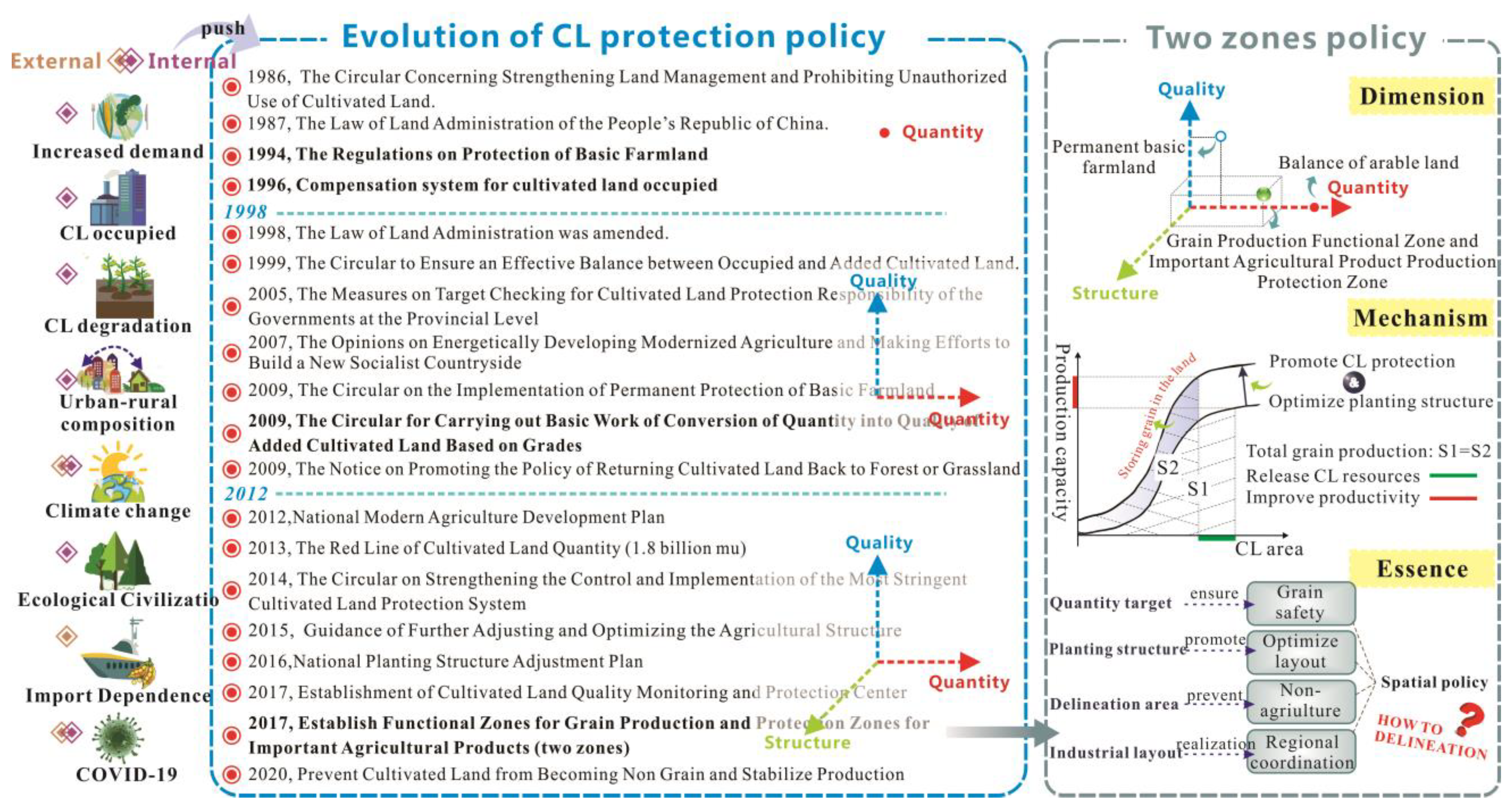
Figure 1. Formation of the trinity of quantity, quality, and structure of the CL protection policy.
Land 12 00806 g001
Figure 2. Overall technical framework of this study.
Land 12 00806 g002
Figure 3. LESA system framework.
Land 12 00806 g003
Figure 4. Location and spatial distribution of CL in Qianguo County ((A). The distribution of the broadly defined black soil region in the Northeast China; (B). The topographic map of Jilin Province and the location of the study area; (C). The distribution of cultivated land resources in Qianguo County).
Land 12 00806 g004
Figure 5. The distribution and proportion of LESA gradation in Qianguo County.
Land 12 00806 g005
Figure 6. The distribution and proportion of cultivation priority types.
Land 12 00806 g006
Figure 7. Spatial cluster pattern of LESA score.
Land 12 00806 g007
Figure 8. Spatial distribution of the CL delineation potential.
Land 12 00806 g008
Figure 9. Spatial distribution of the two zones ((A). Spatial distribution of the two zones; (B). Statistics on the amount of CL delineated into two zones).
Land 12 00806 g009
Figure 10. Composition of the two zones (NPBF is non-permanent basic farmland; NTZ is non-two zone).
Land 12 00806 g010
Figure 11. Two zones policy from county to country.
Land 12 00806 g011
Table 1. Quantitative methods and thresholds of the evaluation index.
FactorSSFTypesThreshold Value
a1a2a3a4
S1SSF1C145.578
C25.577.88.7
C356.578.2
S2 (g·kg−1)SSF2CA1040
S3 (mg·kg−1)SSF2C174122
C290140
C380130
S4 (mg·kg−1)SSF2C1615
C2412
C3412
S5 (mg·kg−1)SSF2C150117
C260140
C344112
T1 (°)SSF3C125
C258
C358
I1SSF4C1Good Moderately goodPoor
C2GoodModerately goodPoor
C3GoodModerately goodPoor
C1SSF4C1PL ILRL
C2RL, IL PL
C3RL, IL PL
F1(ha)SSF2PL0.051.00
RL, IL0.203.33
C1 is rice; C2 is soybean; C3 is maize; CA is crops including rice, soybeans, and maize.
Table 2. Area and percent statistics of each subsystem gradation in Qianguo County.
Quality LevelLE1LE2LE3SA
Area (ha)Percent (%)Area (ha)Percent (%)Area (ha)Percent (%)Area (ha)Percent (%)
Highest51,689.79 16.03 66,864.40 20.74 76,588.03 23.75 114,283.71 35.44
High79,796.57 24.75 115,238.90 35.74 119,802.37 37.15 136,732.95 42.40
Medium121,449.64 37.66 86,093.80 26.70 98,557.79 30.56 62,072.16 19.25
Low69,530.22 21.56 54,269.12 16.83 27,518.02 8.53 9377.39 2.91
Disclaimer/Publisher’s Note: The statements, opinions and data contained in all publications are solely those of the individual author(s) and contributor(s) and not of MDPI and/or the editor(s). MDPI and/or the editor(s) disclaim responsibility for any injury to people or property resulting from any ideas, methods, instructions or products referred to in the content.