
Mapping Groundwater Prospective Areas Using Remote Sensing and GIS-Based Data Driven Frequency Ratio Techniques and Detecting Land Cover Changes in the Yellow River Basin, China


Abstract
1. Introduction
2. Study Area
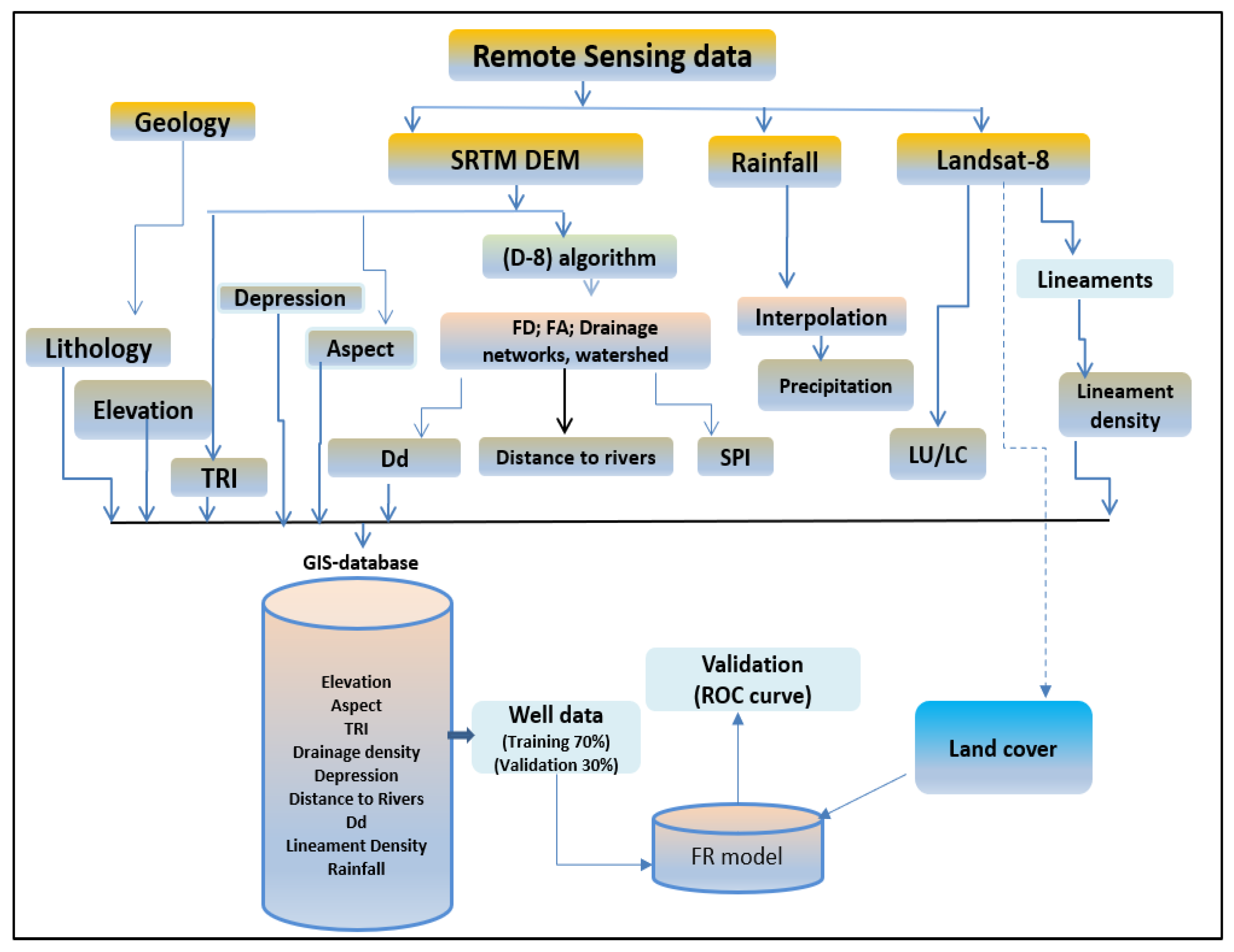
3. Data and Methods
4. Results
4.1. Soil
4.2. Elevation
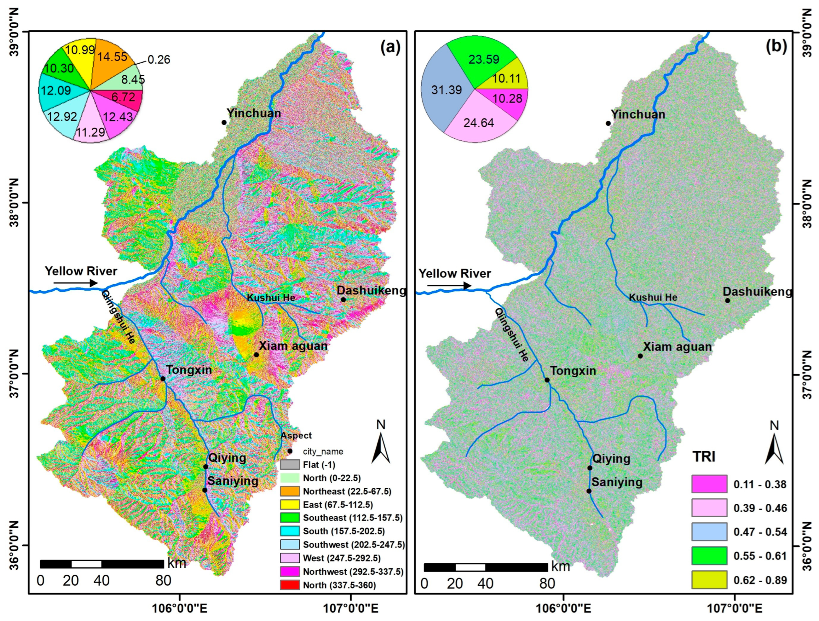
4.3. Aspects
4.4. Topography Roughness Index (TRI)
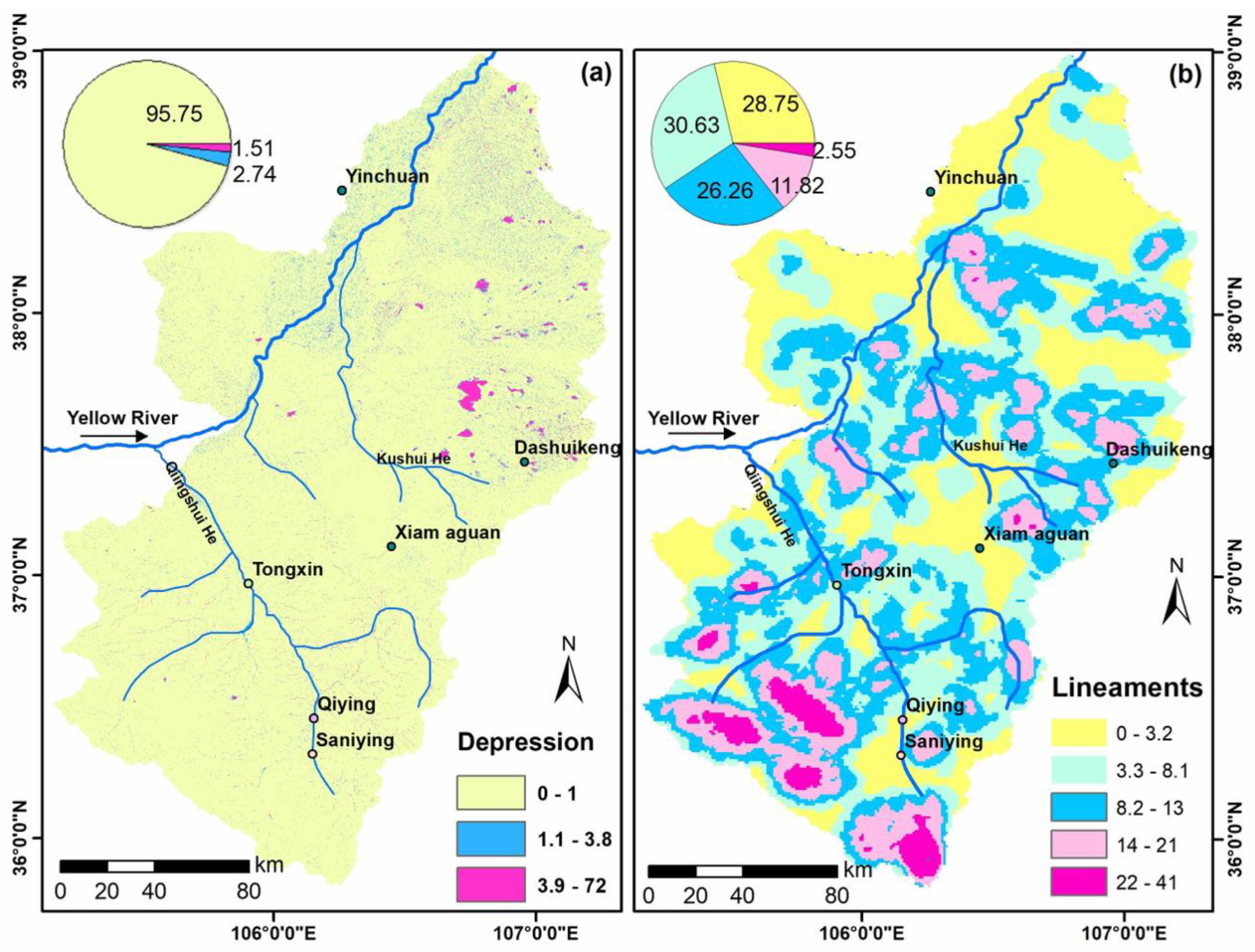
4.5. Depressions/Sinks
4.6. Lineaments
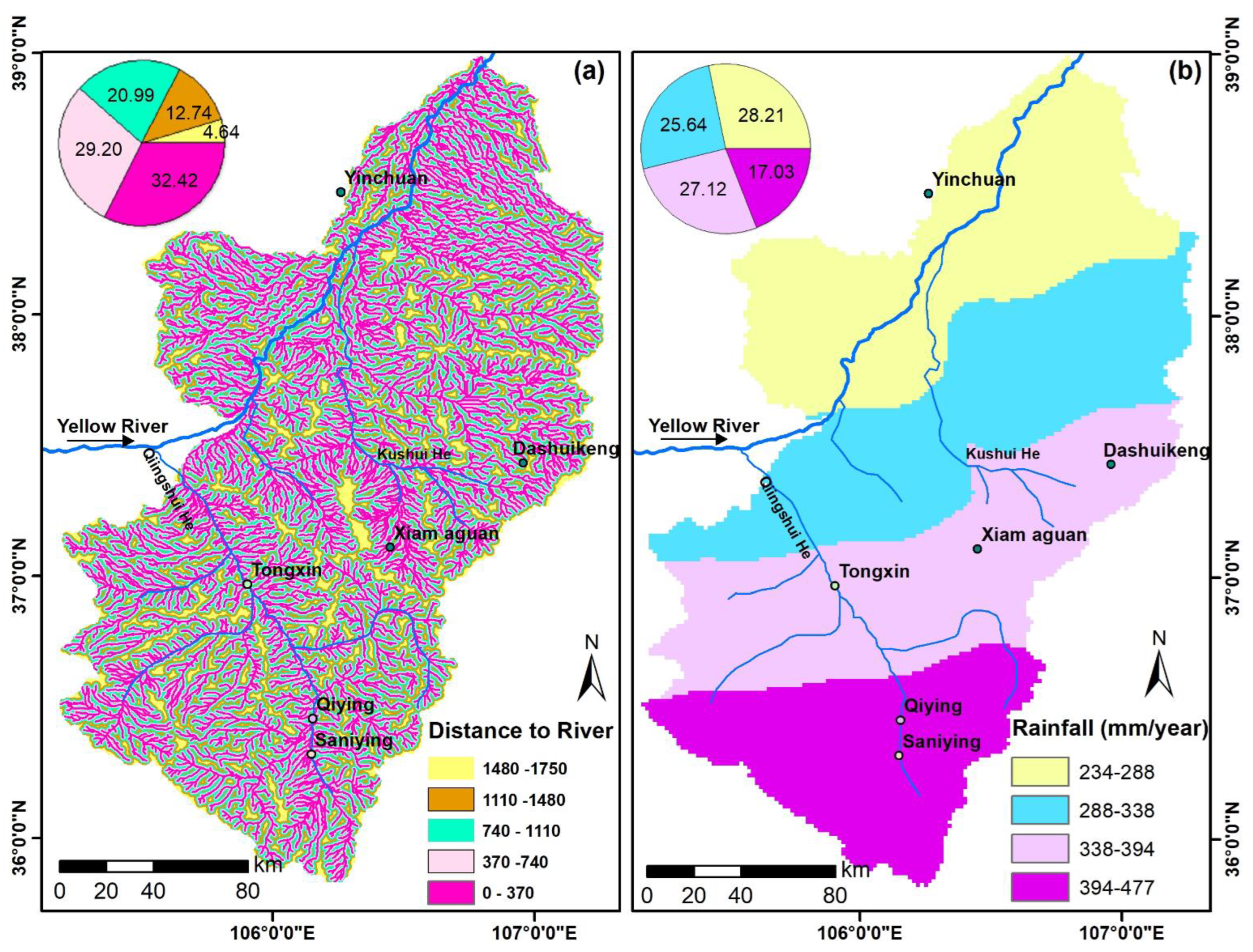
4.7. Distance to River
4.8. Rainfall Data
4.9. Drainage Density (Dd)
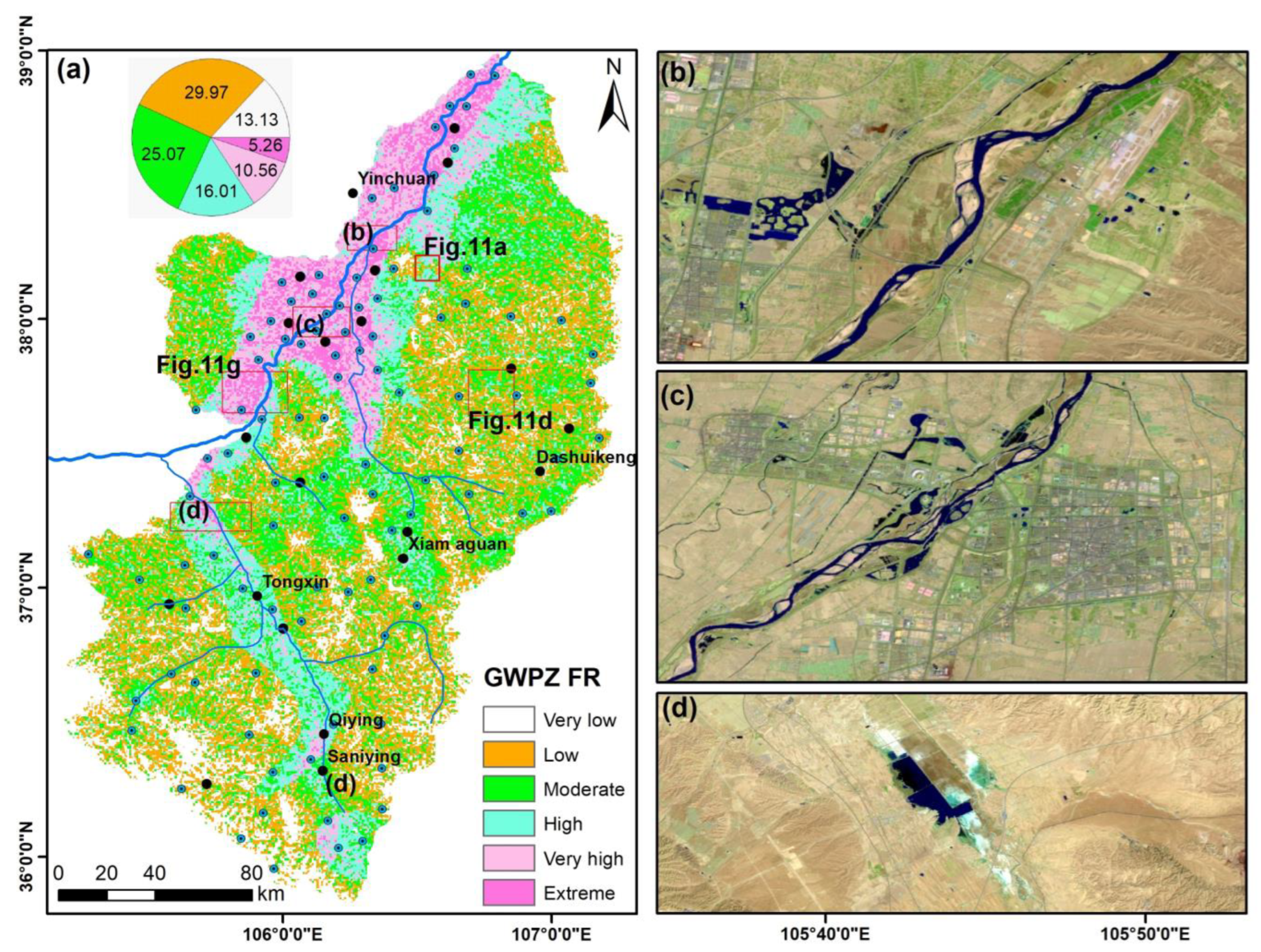
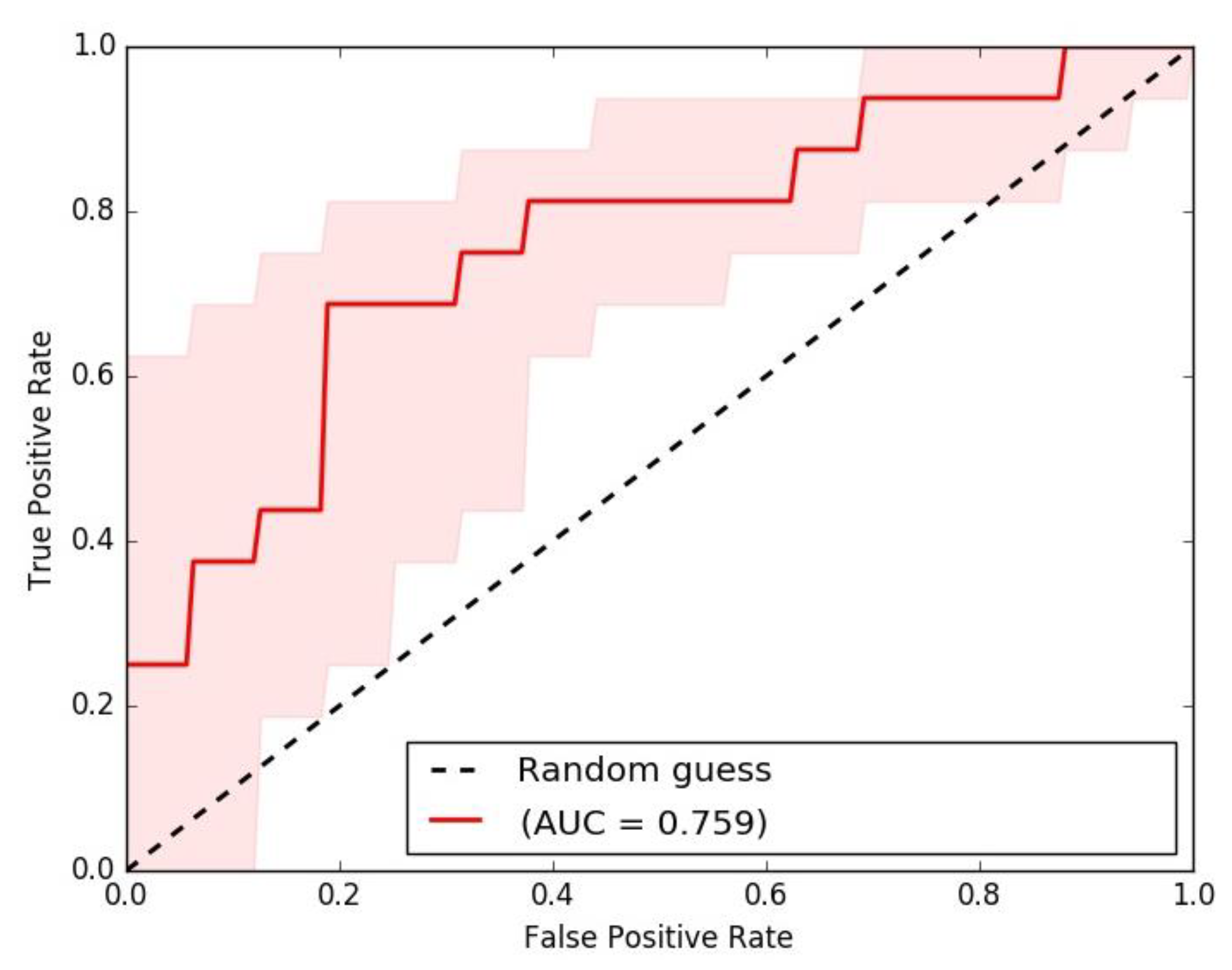
5. Groundwater Potential Mapping and Validation of the Built Models
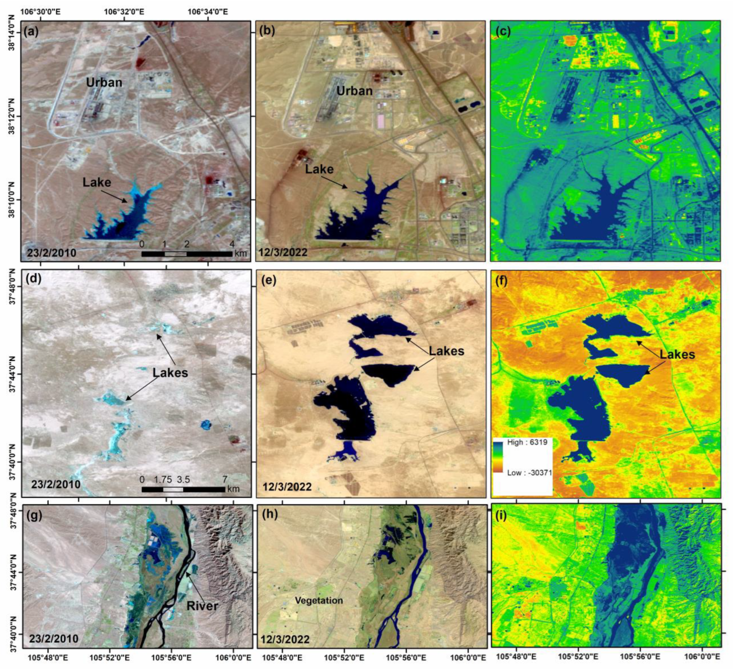
6. Changes Detection of in Land Use Land Cover
7. Discussion
8. Conclusions
Author Contributions
Funding
Data Availability Statement
Acknowledgments
Conflicts of Interest
References
- Abd Manap, M.A.; Sulaiman, W.N.A.; Ramli, M.F.; Pradhan, B.; Surip, N. A knowledge-driven GIS modeling technique for groundwater potential mapping at the Upper Langat Basin, Malaysia. Arab. J. Geosci. 2013, 6, 1621–1637. [Google Scholar] [CrossRef]
- Carmon, N.; Shamir, U. Water-sensitive planning: Integrating water considerations into urban and regional planning. Water Environ. J. 2010, 24, 181–191. [Google Scholar] [CrossRef]
- Jaafarzadeh, M.S.; Tahmasebipour, N.; Haghizadeh, A.; Pourghasemi, H.R.; Rouhani, H. Groundwater recharge potential zonation using an ensemble of machine learning and bivariate statistical models. Sci. Rep. 2021, 11, 5587. [Google Scholar] [CrossRef] [PubMed]
- Mallick, J.; Khan, R.A.; Ahmed, M.; Alqadhi, S.D.; Alsubih, M.; Falqi, I.; Hasan, M.A. Modeling Groundwater Potential Zone in a Semi-Arid Region of Aseer Using Fuzzy-AHP and Geoinformation Techniques. Water 2019, 11, 2656. [Google Scholar] [CrossRef]
- Sun, T.; Cheng, W.; Abdelkareem, M.; Al-Arifi, N. Mapping Prospective Areas of Water Resources and Monitoring Land Use/Land Cover Changes in an Arid Region Using Remote Sensing and GIS Techniques. Water 2022, 14, 2435. [Google Scholar] [CrossRef]
- Jha, M.K.; Bongane, G.M.; Chowdary, V.M. Groundwater potential zoning by remote sensing, GIS and MCDM techniques: A case study of eastern India. In Proceedings of the Symposium JS.4 at the IAHS and IAH convention, Hyderabad, India, 6–12 September 2009; IAHS Press: Wallingford, UK, 2009; pp. 432–441. [Google Scholar]
- Ramachandra, T.V. Soil and Groundwater Pollution from Agricultural Activities; Commonwealth of Learning: Vancouver, BC, Canada; Center for Ecological Science, Indian Institute of Science: Karnataka, India; TERI Press: New Delhi, India, 2006; p. 352. [Google Scholar]
- Abdelkareem, M.; El-Baz, F. Analyses of optical images and radar data reveal structural features and predict groundwater accumulations in the central Eastern Desert of Egypt. Arab. J. Geosci. 2015, 8, 2653–2666. [Google Scholar] [CrossRef]
- Abdelkareem, M.; Abdalla, F. Revealing potential areas of water resources using integrated remote-sensing data and GIS-based analytical hierarchy process. Geocarto Int. 2021, 37, 8672–8696. [Google Scholar] [CrossRef]
- Zhu, Q.; Abdelkareem, M. Mapping groundwater potential zones using a knowledge-driven approach and GIS analysis. Water 2021, 13, 579. [Google Scholar] [CrossRef]
- Arulbalaji, P.; Padmalal, D.; Sreelash, K. GIS and AHP techniques based delineation of groundwater potential zones: A case study from Southern Western Ghats. India Sci. Rep. 2019, 9, 1–17. [Google Scholar] [CrossRef]
- Kumar, V.A.; Mondal, N.C.; Ahmed, S. Identification of groundwater potential zones using RS, GIS and AHP techniques: A case study in a part of Deccan Volcanic Province (DVP), Maharashtra, India. J. Indian Soc. Remote Sens. 2020, 48, 497–511. [Google Scholar] [CrossRef]
- Yariyan, P.; Avand, M.; Omidvar, E.; Pham, Q.B.; Linh, N.; Tiefenbacher, J. Optimization of statistical and machine learning hybrid models for groundwater potential mapping. Geocarto Int. 2020, 11, 2282–2314. [Google Scholar] [CrossRef]
- Abdelkareem, M.; El-Baz, F.; Askalany, M.; Akawy, A.; Ghoneim, E. Groundwater prospect map of Egypt’s Qena Valley using data fusion. Int. J. Image Data Fusion. 2012, 3, 169–189. [Google Scholar] [CrossRef]
- Hong, Y.; Abdelkareem, M. Integration of remote sensing and a GIS-based method for revealing prone areas to flood hazards and predicting optimum areas of groundwater resources. Arab. J. Geosci. 2022, 15, 1–14. [Google Scholar] [CrossRef]
- Abdekareem, M.; Abdalla, F.; Al-Arifi, N.; Bamousa, A.O.; El-Baz, F. Using remote sensing and GIS-based frequency ratio technique for revealing groundwater prospective areas at Wadi Al Hamdh watershed, Saudi Arabia. Water 2023, 15, 1154. [Google Scholar] [CrossRef]
- Pradhan, A.; Nair, A.; Indu, J.; Kirstetter, P.-E. Impact of Sampling of GPM Orbital Data on Streamflow Simulations. J. Hydrol. 2020, 593, 125798. [Google Scholar] [CrossRef]
- Naghibi, S.A.; Pourghasemi, H.R.; Dixon, B. GIS-based groundwater potential mapping using boosted regression tree, classification and regression tree, and random forest machine learning models in Iran. Environ. Monit. Assess. 2016, 188, 44. [Google Scholar] [CrossRef]
- Arshad, A.; Zhang, Z.; Zhang, W.; Dilawar, A. Mapping favorable groundwater potential recharge zones using a GIS-based analytical hierarchical process and probability frequency ratio model: A case study from an agro-urban region of Pakistan. Geosci. Front. 2020, 11, 1805–1819. [Google Scholar] [CrossRef]
- Fan, H.; Lu, Y.; Hu, Y.; Fang, J.; Lv, C.; Xu, C.; Feng, X.; Liu, Y. A Landslide Susceptibility Evaluation of Highway Disasters Based on the Frequency Ratio Coupling Model. Sustainability 2022, 14, 7740. [Google Scholar] [CrossRef]
- Lee, S.; Pradhan, B. Landslide hazard mapping at Selangor, Malaysia using frequency ratio and logistic regression models. Landslides 2007, 4, 33–41. [Google Scholar] [CrossRef]
- Pradhan, B. Landslide susceptibility mapping of a catchment area using frequency ratio, fuzzy logic and multivariate logistic regression approaches. J. Indian Soc. Remote Sens. 2010, 38, 301–320. [Google Scholar] [CrossRef]
- Regmi, A.D.; Yoshida, K.; Pradhan, B.; Pourghasemi, H.R.; Khumamoto, T.; Akgun, A. Application of frequency ratio, statistical index and weights-of-evidence models, and their comparison in landslide susceptibility mapping in Central Nepal Himalaya. Arab. J. Geosci. 2013, 7, 725–742. [Google Scholar] [CrossRef]
- Nampak, H.; Pradhan, B.; Manap, M.A. Application of GIS based data driven evidential belief function model to predict groundwater potential zonation. J. Hydrol. 2014, 513, 283–300. [Google Scholar] [CrossRef]
- Razandi, Y.; Pourghasemi, H.Z.; NajmehSamaniNeisani, N.S.; Rahmati, O. Application of analytical hierarchy process, frequency ratio, and certainty factor models for groundwater potential mapping using GIS. Earth Sci. Inform. 2015, 8, 867–883. [Google Scholar] [CrossRef]
- Guru, B.; Seshan, K.; Bera, S. Frequency ratio model for groundwater potential mapping and its sus_tainable management in cold desert, India. J. King Saud Univ. Sci. 2017, 29, 333–347. [Google Scholar] [CrossRef]
- Neshat, A.; Pradhan, B. An integrated DRASTIC model using frequency ratio and two new hybrid methods for groundwater vulnerability assessment. Nat. Hazards 2015, 76, 543–563. [Google Scholar] [CrossRef]
- Ahmadi, H.; Kaya, O.A.; Babadagi, E.; Savas, T.; Pekkan, E. GIS-Based Groundwater Potentiality Mapping Using AHP and FR Models in Central Antalya, Turkey. Environ. Sci. Proc. 2021, 5, 11. [Google Scholar] [CrossRef]
- Muavhi, N.; Thamaga, K.H.; Mutoti, M.I. Mapping groundwater potential zones using relative frequency ratio, analytic hierarchy process and their hybrid models: Case of Nzhelele-Makhado area in South Africa. Geocarto Int. 2022, 37, 6311–6330. [Google Scholar] [CrossRef]
- Ozdemir, A. GIS-based groundwater spring potential mapping in the Sultan Mountains (Konya, Turkey) using frequency ratio, weights of evidence and logistic regression methods and their comparison. J. Hydrol. 2011, 411, 290–308. [Google Scholar] [CrossRef]
- Davoodi Moghaddam, D.; Rezaei, M.; Pourghasemi, H.R.; Pourtaghi, Z.S.; Pradhan, B. Groundwater spring potential mapping using bivariate statistical model and GIS in the Taleghan watershed Iran. Arab. J. Geosci. 2001, 10 (Suppl. S2), S96–S101. [Google Scholar] [CrossRef]
- Li, Y.; Abdelkareem, M.; Al-Arifi, N. Mapping Potential Water Resource Areas Using GIS-Based Frequency Ratio and Evidential Belief Function. Water 2023, 15, 480. [Google Scholar] [CrossRef]
- Pradhan, B. Ground water potential zonation for basaltic watersheds using satellite remote sensing data and GIS techniques. Cent. Eur. J. Geosci. 2009, 1, 120–129. [Google Scholar]
- Ayazi, M.H.; Pirasteh, S.; Arvin, A.K.P.; Pradhan, B.; Nikouravan, B.; Mansor, S. Disasters and risk reduction in groundwater: Zagros mountain southwest Iran using geo-informatics techniques. Dis. Adv. 2010, 3, 51–57. [Google Scholar]
- Selvarani, A.G.; Maheswaran, G.; Elangovan, K. Identification of Artificial Recharge Sites for Noyyal River Basin Using GIS andRemote Sensing. J. Indian Soc. Remote Sens. 2017, 45, 67–77. [Google Scholar] [CrossRef]
- Sahour, H.; Gholami, V.; Vazifedan, M.; Saeedi, S. Machine Learning Applications for Water-Induced Soil Erosion Modeling and Mapping. Soil Tillage Res. 2021, 211, 105032. [Google Scholar] [CrossRef]
- Folharini, S.; Vieira, A.; Bento-Gonçalves, A.; Silva, S.; Marques, T.; Novais, J. Soil Erosion Quantification using Machine Learning in Sub-Watersheds of Northern Portugal. Hydrology 2023, 10, 7. [Google Scholar] [CrossRef]
- Rahmati, O.; Melesse, A.M. Application of Dempster–Shafer theory, spatial analysis and remote sensing for groundwater potentiality and nitrate pollution analysis in the semi-arid region of Khuzestan, Iran. Sci. Total Environ. 2016, 568, 1110–1123. [Google Scholar] [CrossRef]
- Al Saud, M. Mapping potential areas for groundwater storage in wadiaurnah basin, western Arabian peninsula, using remote sensing and geographic information system techniques. Hydrogeol. J. 2010, 18, 1481–1495. [Google Scholar] [CrossRef]
- Ettazarini, S. Groundwater potential index: A strategically conceived tool for water research in fractured aquifers. Environ. Geol. 2007, 52, 477–487. [Google Scholar] [CrossRef]
- Mukherjee, I.; Singh, U.K. Delineation of groundwater potential zones in a drought-prone semi-arid region of east India using GIS and analytical hierarchical process techniques. Catena 2020, 194, 104681. [Google Scholar] [CrossRef]
- Villeneuve, S.; Cook, P.; Shanafield, M.; Wood, C.; White, N. Groundwater recharge via infiltration through an ephemeral riverbed, central Australia. J. Arid. Environ. 2015, 117, 47–58. [Google Scholar] [CrossRef]
- Magesh, N.S.; Chandrasekar, N.; Soundranayagam, J.P. Delineation of groundwater potential zones in Theni district, Tamil Nadu, using remote sensing, GIS and MIF techniques. Geosci. Front. 2012, 3, 189–196. [Google Scholar] [CrossRef]
- Shekhar, S.; Pandey, A.C. Delineation of groundwater potential zonein hard rock terrain of India using remote sensing, geographicalinformation system (GIS) and analytic hierarchy process (AHP)techniques. Geocarto Int. 2014, 30, 402–421. [Google Scholar] [CrossRef]
- Wang, X.; Zheng, W.; Tian, W.; Gao, Y.; Wang, X.; Tian, Y.; Li, J.; Zhang, X. Groundwater hydrogeochemical characterization and quality assessment based on integrated weight matter-element extension analysis in Ningxia, upper Yellow River, northwest China. Ecol. Indic. 2022, 135, 108525. [Google Scholar] [CrossRef]
- Mi, L.; Tian, J.; Si, J.; Chen, Y.; Li, Y.; Wang, X. Evolution of groundwater in yinchuan oasis at the upper reaches of the yellow river after water-saving transformation and its driving factors. Int. J. Environ. Res. Public Health 2020, 17, 1304. [Google Scholar] [CrossRef]
- Gao, X.; Wang, W.; Hou, B.; Gao, L.; Zhang, J.; Zhang, S.; Li, C.; Jiang, C. Analysis of karst groundwater pollution in northern China. Carsologica Sinica. 2020, 39, 287–289. [Google Scholar] [CrossRef]
- O’Callaghan, J.F.; Mark, D.M. The extraction of drainage networks from digital elevation data. Comput. Vis. Graph. Image Process. 1984, 28, 323–344. [Google Scholar] [CrossRef]
- Allafta, H.; Opp, C.; Patra, S. Identification of Groundwater Potential Zones Using Remote Sensing and GIS Techniques: A Case Study of the Shatt Al-Arab Basin. Remote Sens. 2021, 13, 112. [Google Scholar] [CrossRef]
- Eastman, J.R.; Jin, W.; Kyem, A.K.P.; Toledano, J. Raster procedure for multi-criteria/multi-objective decisions. Photogramm. Eng. Remote Sens. 1995, 61, 539–547. [Google Scholar]
- Pradhan, A.M.S.; Kim, Y.T. Relative e_ect method of landslide susceptibility zonation in weathered granite soil: A case study in Deokjeok-ri Creek, South Korea. Nat. Hazards 2014, 72, 1189–1217. [Google Scholar] [CrossRef]
- Benjmel, K.; Amraoui, F.; Boutaleb, S.; Ouchchen, M.; Tahiri, A.; Touab, A. Mapping of groundwater potential zones in crystalline terrain using remote sensing, GIS techniques, and multicriteria data analysis (case of the Ighremregion, western Anti-Atlas, Morocco). Water 2020, 12, 471. [Google Scholar] [CrossRef]
- Al-Djazouli, M.O.; Elmorabiti, K.; Rahimi, A.; Amellah, O. Fadil OAM.Delineating of groundwater potential zones based on remote sensing, GIS and analytical hierarchical process: A case of Waddai, eastern Chad. Geojournal 2020, 86, 1881–1894. [Google Scholar] [CrossRef]
- Abdelkareem, M. Targeting flash flood potential areas using remotely sensed data and GIS techniques. Nat. Hazards J. 2017, 85, 19–37. [Google Scholar] [CrossRef]
- Avand, M.; Janizadeh, S.; Tien Bui, D.; Pham, V.H.; Ngo, P.T.T.; Nhu, V.-H. A tree-based intelligence ensemble approach for spatial prediction of potential groundwater. Int. J. Digital Earth 2020, 13, 1408–1422. [Google Scholar] [CrossRef]
- Lakshmi, S.; Reddy, Y. Identification of groundwater potential zones using GIS and remote sensing. Int. J. Pure Appl. Math. 2018, 119, 3195–3210. [Google Scholar]
- Gebhardt, C.; Theis, S.E.; Paulat, M.; Ben-Bouallègue, Z. Uncertainties in COSMO-DE precipitation forecasts introduced by model perturbations and variation of lateral boundaries. Atmos. Res. 2011, 100, 168–177. [Google Scholar] [CrossRef]
- Kanagaraj, G.; Suganthi, S.; Elango, L.; Magesh, N. Assessment of groundwater potential zones in Vellore district, Tamil Nadu, India using geospatial techniques. Earth Sci. Inf. 2019, 12, 211–223. [Google Scholar] [CrossRef]
- Harini, P.; Sahadevan, D.K.; Das, I.C.; Manikyamba, C.; Durgaprasad, M.; Nandan, M.J. Regional groundwater assessment of Krishna RiverBasin using integrated GISapproach. J. Indian Soc. Remote Sens. 2018, 46, 1365–1377. [Google Scholar] [CrossRef]
- Janizadeh, S.; Avand, M.; Jaafari, A.; Phong, T.V.; Bayat, M.; Ahmadisharaf, E.; Prakash, I.; Pham, B.T.; Lee, S. Prediction success of machine learning methods for flash flood susceptibility mapping in the tafresh watershed, Iran. Sustainability 2019, 11, 5426. [Google Scholar] [CrossRef]
- Lee, S.; Pradhan, B. Probabilistic landslide hazards and risk mapping on Penang Island, Malaysia. J. Earth Syst. Sci. 2006, 115, 661–672. [Google Scholar] [CrossRef]
- Dawood, F.; Akhtar, M.M.; Ehsan, M. Evaluating urbanization impact on stressed aquifer of Quetta Valley, Pakistan. Desalination Water Treat. 2021, 222, 103–113. [Google Scholar] [CrossRef]
- Kalantar, B.; Al-Najjar HA, H.; Pradhan, B.; Saeidi, V.; Abdul Halin, A.; Ueda, N.; Naghibi, S.A. Optimized Conditioning Factors Using Machine Learning Techniques for Groundwater Potential Mapping. Water 2019, 11, 1909. [Google Scholar] [CrossRef]
- Moghaddam, D.; Rahmati, O.; Haghizadeh, A.; Kalantari, Z. A Modeling Comparison of Groundwater Potential Mapping in a Mountain Bedrock Aquifer: QUEST, GARP, and RF Models. Water 2020, 12, 679. [Google Scholar] [CrossRef]
- Anbazhagan, S.; Ramasamy, S.; Das Gupta, S. Remote sensing and GIS for artificial recharge study, runoff estimation and planning in Ayyar basin, Tamil Nadu, India. Environ. Geol. 2005, 48, 158–170. [Google Scholar] [CrossRef]
- Opp, C. Bodenkörper. In Geographie—Physische Geographie und Humangeographie, 3rd ed.; Gebhardt, H., Glaser, R., Radtke, U., Reuber, P., Vött, A., Eds.; Springer: Berlin, Germany, 2011; pp. 485–490. [Google Scholar]
- Achu, A.L.; Reghunath, R.; Thomas, J. Mapping of Groundwater Recharge Potential Zones and Identification of Suitable Site-Specific Recharge Mechanisms in a Tropical River Basin. J. Earth Syst. Environ. 2020, 4, 131–145. [Google Scholar] [CrossRef]
- Berhanua, K.G.; Hatiye, S.D. Identification of Groundwater Potential Zones Using Proxy Data: Case study of Megech Watershed, Ethiopia Kibrit Gedam Berhanua, Samuel Dagalo Hatiye. J. Hydroogy: Reg. Stud. 2020, 28, 100676. [Google Scholar]
- Gaur, S.; Chahar, B.R.; Graillot, D. Combined use of groundwater modeling and potential zone analysis for management of groundwater. Int. J. Appl. Earth Obs. Geoinf. 2011, 13, 127–139. [Google Scholar] [CrossRef]
- Acharya, T.; Nag, S.K.; Basumallik, S. Hydraulic significance of fracture correlated lineaments in precam_brian rocks in Purulia district, West Bengal. J. Geol. Soc. India 2012, 80, 723–730. [Google Scholar] [CrossRef]
- Hossein, A.; Ardakani, H.; Ekhtesasi, M.R. Groundwater potentiality through Analytic Hierarchy Process (AHP) using remote sensing and Geographic Information System (GIS). J. Geope 2016, 6, 75–88. [Google Scholar]
- Gannouni, S.; Gabtni, H. Structural interpretation of lineaments by satellite image processing (Landsat TM) in the region of Zahret Medien (Northern Tunisia). J. Geogr. Inf. Syst. 2015, 7, 119. [Google Scholar] [CrossRef]
- Razavi-Termeh, S.V.; Sadeghi-Niaraki, A.; Choi, S. Groundwater Potential Mapping Using an Integrated Ensemble of Three Bivariate Statistical Models with Random Forest and Logistic Model Tree Models. Water 2019, 11, 1596. [Google Scholar] [CrossRef]
- Alarifi, S.S.; Abdelkareem, M.; Abdalla, F.; Alotaibi, M. Flash Flood Hazard Mapping Using Remote Sensing and GIS Techniques in Southwestern Saudi Arabia. Sustainability 2022, 14, 14145. [Google Scholar] [CrossRef]
- Abdekareem, M.; Al-Arifi, N.; Abdalla, F.; Mansour, A.; El-Baz, F. Fusion of Remote Sensing Data Using GIS-Based AHP-Weighted Overlay Techniques for Groundwater Sustainability in Arid Regions. Sustainability 2022, 14, 7871. [Google Scholar] [CrossRef]
- Lentswe, G.B.; Lentswe, M. Delineation of potential groundwater recharge zones using analytic hierarchy 725 process-guided GIS in the semi-arid Motloutse watershed, eastern Botswana. J. Hydrol. Reg. Stud. 2020, 28, 100674. [Google Scholar] [CrossRef]
- Pande, C.B.; Khadri, F.R.; Moharir, K.N.; Patode, R.S. Assessment of groundwater potential zonation of Mahesh 722 River basin Akola and Buldhana districts, Maharashtra, India using remote sensing and GIS techniques. Sustain. Water Resour. Manag. 2018, 4, 965–979. [Google Scholar] [CrossRef]
- Abdelkareem, M.; Al-Arifi, N. The use of remotely sensed data to reveal geologic, structural, and hydrologic features and predict potential areas of water resources in arid regions. Arab. J. Geosci. 2021, 14, 1–15. [Google Scholar] [CrossRef]


| Elevation | No. Pixels in Domain | Domain % | No. Wells | No. Wells % | FR |
|---|---|---|---|---|---|
| 1087 to 1276 | 1,016,102 | 0.19 | 38 | 0.38 | 1.97 |
| 1276 to 1479 | 1,641,795 | 0.31 | 20 | 0.2 | 0.64 |
| 1479 to 1705 | 1,315,398 | 0.25 | 24 | 0.24 | 0.96 |
| 1705 to 1998 | 942,575 | 0.18 | 15 | 0.15 | 0.84 |
| 1998 to 2941 | 349,645 | 0.07 | 3 | 0.03 | 0.45 |
| TRI classes | |||||
| 0.614 to 0.889 | 542,030 | 0.10 | 12 | 0.12 | 1.17 |
| 0.535 to 0.614 | 1,244,420 | 0.24 | 21 | 0.21 | 0.89 |
| 0.461 to 0.535 | 1,655,667 | 0.31 | 27 | 0.27 | 0.86 |
| 0.379 to 0.461 | 1,299,650 | 0.25 | 24 | 0.24 | 0.97 |
| 0.111 to 0.379 | 533,086 | 0.10 | 16 | 0.16 | 1.58 |
| Dd reclasses | |||||
| 5.31 to 31.10 | 6537 | 0.12 | 6 | 0.06 | 0.49 |
| 31.20 to 43.10 | 15,167 | 0.29 | 26 | 0.26 | 0.91 |
| 43.20 to 54.30 | 15,598 | 0.29 | 30 | 0.3 | 1.02 |
| 54.40 to 66.70 | 11,203 | 0.21 | 24 | 0.24 | 1.14 |
| 66.80 to 101 | 4551 | 0.09 | 14 | 0.14 | 1.63 |
| Soil | |||||
| Calcic xerosols | 13,224 | 0.261334 | 21 | 0.21 | 0.80 |
| Luvic xerosols | 332 | 0.006561 | 0 | 0 | 0.00 |
| Lithosols | 26,848 | 0.530572 | 35 | 0.35 | 0.66 |
| Eutric Gleysols | 9759 | 0.192858 | 43 | 0.43 | 2.23 |
| Calcic cambisols | 439 | 0.008676 | 1 | 0.01 | 1.15 |
| Dist River | |||||
| 1480 to 1750 | 1,870,410 | 0.046373 | 0 | 0 | 0 |
| 1110 to 1480 | 5,139,914 | 0.127435 | 12 | 0.12 | 0.94 |
| 740 to 1110 | 8,467,401 | 0.209934 | 13 | 0.13 | 0.62 |
| 370 to 740 | 11,778,792 | 0.292033 | 32 | 0.32 | 1.10 |
| 0 to 370 | 13,077,205 | 0.324225 | 43 | 0.43 | 1.33 |
| Depression | |||||
| 0 to 1 | 5,041,843 | 0.957521 | 95 | 0.95 | 0.99 |
| 1 to 3.8 | 144,133 | 0.027373 | 4 | 0.04 | 1.46 |
| 3.8 to 72 | 79,539 | 0.015106 | 1 | 0.01 | 0.66 |
| ASPECT | |||||
| Flat (−1) | 13,758 | 0.002613 | 0 | 0 | 0 |
| North (0–22.5) | 444,969 | 0.084506 | 20 | 0.2 | 2.37 |
| Northeast (22.5–67.5) | 766,094 | 0.145493 | 20 | 0.2 | 1.37 |
| East (67.5–112.5) | 578,467 | 0.10986 | 4 | 0.04 | 0.36 |
| Southeast (112.5–157.5) | 542,320 | 0.102995 | 6 | 0.06 | 0.58 |
| South (157.5–202.5) | 636,523 | 0.120885 | 11 | 0.11 | 0.91 |
| Southwest (202.5–247.5) | 680,426 | 0.129223 | 9 | 0.09 | 0.70 |
| West (247.5–292.5) | 594,492 | 0.112903 | 12 | 0.12 | 1.06 |
| Northwest (292.5–337.5) | 654,449 | 0.12429 | 13 | 0.13 | 1.05 |
| North (337.5–360) | 354,017 | 0.067233 | 5 | 0.05 | 0.74 |
| Lineaments | |||||
| 0 to 3.3 | 14,814 | 0.29 | 34 | 0.34 | 1.18 |
| 3.3 to 8.04 | 15,780 | 0.31 | 30 | 0.3 | 0.98 |
| 8.04 to 13.30 | 13,530 | 0.26 | 23 | 0.23 | 0.88 |
| 13.30 to 21.10 | 6090 | 0.12 | 10 | 0.1 | 0.85 |
| 21.10 to 40.87 | 1312 | 0.03 | 3 | 0.03 | 1.18 |
| Precipitation | |||||
| 234 to 288 | 4585 | 0.28 | 34 | 0.34 | 1.21 |
| 288 to 338 | 4168 | 0.26 | 26 | 0.26 | 1.01 |
| 338 to 394 | 4408 | 0.27 | 25 | 0.25 | 0.92 |
| 394 to 477 | 3094 | 0.19 | 15 | 0.15 | 0.79 |
Disclaimer/Publisher’s Note: The statements, opinions and data contained in all publications are solely those of the individual author(s) and contributor(s) and not of MDPI and/or the editor(s). MDPI and/or the editor(s) disclaim responsibility for any injury to people or property resulting from any ideas, methods, instructions or products referred to in the content. |
© 2023 by the authors. Licensee MDPI, Basel, Switzerland. This article is an open access article distributed under the terms and conditions of the Creative Commons Attribution (CC BY) license (https://creativecommons.org/licenses/by/4.0/).
Share and Cite
Li, S.; Abdelkareem, M.; Al-Arifi, N. Mapping Groundwater Prospective Areas Using Remote Sensing and GIS-Based Data Driven Frequency Ratio Techniques and Detecting Land Cover Changes in the Yellow River Basin, China. Land 2023, 12, 771. https://doi.org/10.3390/land12040771
Li S, Abdelkareem M, Al-Arifi N. Mapping Groundwater Prospective Areas Using Remote Sensing and GIS-Based Data Driven Frequency Ratio Techniques and Detecting Land Cover Changes in the Yellow River Basin, China. Land. 2023; 12(4):771. https://doi.org/10.3390/land12040771
Chicago/Turabian StyleLi, Shuhang, Mohamed Abdelkareem, and Nassir Al-Arifi. 2023. "Mapping Groundwater Prospective Areas Using Remote Sensing and GIS-Based Data Driven Frequency Ratio Techniques and Detecting Land Cover Changes in the Yellow River Basin, China" Land 12, no. 4: 771. https://doi.org/10.3390/land12040771
APA StyleLi, S., Abdelkareem, M., & Al-Arifi, N. (2023). Mapping Groundwater Prospective Areas Using Remote Sensing and GIS-Based Data Driven Frequency Ratio Techniques and Detecting Land Cover Changes in the Yellow River Basin, China. Land, 12(4), 771. https://doi.org/10.3390/land12040771