1. Introduction
Forecasts of the expected increase in urbanization and urban population in the coming decades, as well as the pressure this puts on the planet, have given new political momentum to the quality of life in and sustainability of cities (Douglas, Lennon and Scott, 2017). Compact and renaturalised cities with high population densities, a mix of uses and well-functioning public transport (transit-oriented development) and promotion of cycling and walking [
1] are seen as counterbalances to the continued increase in urbanization and urban sprawl [
2,
3,
4,
5].
However, the balance between urban density, quality of urban space, quality of life and health is not a settled issue. This is the case because, among other reasons, creation of dense cities and densification of existing urban fabrics reduce the space available for green areas, which are, in turn, considered the key to the quality of life in cities, their sustainability and the health of the urban population [
6,
7,
8].
Indeed, in a review article published in 2015, Haaland and Konijnendijk stated that there is growing evidence of loss of urban green space due to urban densification processes on a global scale. From 2015 to the present, this trend of decreasing urban green space has been noted by many other scholars [
9,
10,
11]. Densification and greening, which seem to be necessary conditions for urban spaces’ sustainability and quality, are contradictory goals. Some authors see this as one of the paradoxes of sustainable development principles [
2,
7,
12,
13,
14]. While densification is essential for environmental and landscape protection, urban green spaces are important in combating climate change as well as mitigating its effects, improving air quality, reducing surface runoff, mitigating heat island effect, creating habitats for wildlife and generally enhancing biodiversity [
14,
15,
16,
17].
Although the advantages and benefits of urban green spaces are increasingly well-known, the amount of greenery that urban dwellers need is still a matter of scientific debate [
8,
15]. This is a handicap for planners and managers of urban green spaces [
16], considering that knowing the relationship between population size and quality and quantity of green space is vital in terms of sustainability, health and resilience of urban areas [
8,
14]. This is a particularly complex issue because it is not only the total amount of green space per unit area that counts but also the quality of that green space [
8,
18,
19,
20], its accessibility [
8,
21] and its distribution throughout the urban fabric [
22]. Purely quantitative standards without consideration of access to green spaces are not meaningful when applied at the urban scale, where information on green surfaces per inhabitant can mask deficiencies on other scales [
1,
23].
The problem of green spaces is more pressing in compact cities and in cities undergoing densification processes. This is an accepted and well-known fact that has received its own responses and proposals from distinct scholarly communities. Within the ecosystem services research framework, there is an emphasis on the need for careful planning and a solid knowledge base on how essential ecosystem services can be provided within the limited area of green space in a compact city [
1]. From the theoretical frameworks of green infrastructure (GI) and landscape ecology—demanded by many authors as a framework for urban green-space planning—the keys are connectivity and networked planning [
1]. In any case, solving the problem of the compact-city and sustainability paradox and the consequent need to manage the trade-offs between compact and green cities requires integrative approaches capable of encompassing a holistic understanding of the relationships between built and green components and their underlying social, economic and ecological drivers [
2]. It also requires a union of knowledge from disparate expertise and disciplines, bridging of the gaps between research and application and between science and practice [
19] (p. 312) and exploration of new forms of interaction between government bodies, citizens and other nonstate actors (e.g., universities and institutes of research) [
24]. The separation of knowledge and research on urban green issues into disconnected silos has been a recurrent issue in urban green research. Escobedo et al. (2019) spoke of the conceptual segregation of a group of ideas, similar in spirit and letter, that is not conducive to desirable and integrative transdisciplinary research. The title of the article by Escobedo et al. mentions four of the most prominent research approaches (urban forests, ecosystem services, green infrastructure and nature-based solutions), asking whether these are related approaches or evolving metaphors. Jim (2004) defined the situation very well when he pointed out that the necessary knowledge to affect fine greenery in compact cities exists disparately in a cluster of cognate fields, which need to be knitted together into an implementable package [
19] (p. 318).
This research explores the possibilities of renaturalising a particularly dense urban area within the framework of the theoretical background mentioned above: careful planning based on analysis of the relationship between open spaces and built spaces, aided with a thorough analysis of the urban fabric and bringing together knowledge and methods from different fields (architecture, ecology and geography). In addition to this, this work intends to pay special attention to green surfaces that are integrated into the urban fabric, in line with a new approach (or challenge) to aspirations/ideal conditions with respect to green surfaces in residential spaces. The objective is to focus on greening that is capable of improving provisions of green spaces and green elements within disadvantaged urban fabrics so that they become elements that are part of the daily landscape of residents and do not require travel to enjoy them and their benefits. This objective is based on a proposal recently made by Cecil Konijnendijk (2022). This urban forester proposed as a goal that each citizen, in addition to living no farther than 300 m from a park or green space, should live in a location that allows them to see from their home at least three trees of acceptable size and in the built-up area of which there is 30 percent tree-canopy cover (the “3–30–300 rule”) [
25]. This is an issue that is also supported with evidence and proposals concerning equity (or lack thereof) in distribution of green areas in different neighbourhoods or districts of European cities [
26].
In this work, we also looked for alternatives to create a network aimed at increasing quality of life through green spaces and the ecosystem services they provide; placing connectivity between green elements as a condition for a new network aimed at providing a means of ecological and social connection within the study area; exploring the possibilities of using and creating small green spaces, from a conception that neither can nor seeks to prioritise the quantity but rather the quality of green spaces, their connectivity and their contribution to the improvement of the most damaged urban spaces. In short, the aim was to carry out research to help identify the potential and possibilities for renaturation of compact and complex urban spaces through the creation of a green connectivity network.
2. The Small-Scale Urban Green Spaces
The difficulty of greening compact cities and the possible options to achieving it have nurtured a particularly and increasingly interesting research line. We are referring to research on small-scale urban green spaces (identified with various names), which is based on growing evidence of the benefits of urban green spaces (hereafter referred to as UGSs), regardless of their size, and on the need to find alternatives for greening compact cities.
Research on small-scale urban green spaces has defined them as small in size, low in cost, easily accessible, flexible in form and location [
27] and located in residual spaces within dense urban areas [
28,
29,
30,
31,
32,
33].
Small green spaces are given different names in the scientific literature. Zhang and Han (2021) collected some of these names in a review article in which they also showed that there is no common definition that reflects a state of consensus in relation to their nature, size and characteristics. Zhang and Han (2021) reviewed the scientific literature in English using the concepts of pocket park, minipark, vest pocket park, green space, small urban park and small green space, all of which refer to small green areas within urban spaces. On the other hand, a literature review of existing papers allowed us to detect other concepts: “small green areas”, “Small scale green infrastructure” and “small-scale urban nature parks”. To refer to all of them together, we will henceforth use one of the terms commonly used in the scientific literature: small urban green spaces (SUGSs).
According to the results of the review article by Zhang and Han (2021) and our own review for this research, the size of SUGSs is perhaps the aspect that introduces the greatest variability in research and, therefore, in the scope and applicability of the results. Evidence of the benefits of SUGSs, which has emerged from empirical research on the services they provide and from research on the uses and preferences of users in different parts of the world, has been obtained on the basis of green spaces of different categories and sizes. The inventories that underpin research on UGSs and SUGSs were conducted according to pre-established ad hoc criteria that included or excluded certain types of green spaces, based on their composition, location or size. This reflects, as Zhang and Han pointed out, a problem in lack of agreement on the definition of SUGSs and has the consequence of undermining generalisability of results and, as mentioned above, their applicability in practice.
The relationship between the sizes of green spaces and the benefits they provide (environmental, social, health, etc.) is a relevant issue. When planning SUGSs in cities or compact spaces with a shortage of available land, it is important to decide to what extent the minimum size of spaces that can be greened matters, which in reality amounts to asking whether or not there is a minimum size required for a green area to have an effect on health and wellbeing [
21]. Ekkel and de Vries (2017) [
21] concluded that with regard to stress reduction and attention restoration, there seems to be no minimum size [
21]. They mentioned, in fact, three previous research studies whose results strongly suggested that having even small green areas nearby contributes to the mental health of people. Ha et al. (2022) [
22] also compiled studies that have shown that small green spaces provide short but frequent contact with nature, which, in turn, promotes social interaction and cohesion among the population. However, beyond the positive effects of green spaces—whatever their size—on stress and mental health, there is not enough scientific knowledge to know at the design stage of SUGSs how effective they will be in terms of ecology, health and wellbeing. On one hand, the variability in the characteristics of the sizes and compositions of the SUGSs being investigated makes extrapolation of results on the benefits of SUGSs risky. On the other hand, as Ortega-Alvarez and MacGregor-Fors (2009) [
34] (p. 194) pointed out, although some urban ecology patterns were consistent among studies, efforts to achieve urban-planning and management recommendations are not consistent among countries. They added that, as each city is a unique system, its management and planning activities should be continuously evaluated to measure their effectiveness.
The expression most commonly used in research on SUGSs is pocket park. The origin of this expression dates back to the period immediately after the Second World War, in the context of the process of reconstruction of cities ruined during the war. Included in this process was designing of small parks as recreational spaces on sites that were devastated by earlier bombings [
35]. In such a context, the objectives of mini-parks are primarily recreational and to be places for socialisation. More recently, however, small green spaces are being analysed as providers of other ecosystem services beyond the recreational, and today, we have already found research on the idea of creating pocket parks to make a sustainable neighbourhood in a highly dense city [
36,
37] and particularly for generating wellbeing spaces within cities and neighbourhoods. Lu et al. (2022) [
38] considered that exposure to small public urban green spaces (SPUGSs) has been demonstrated to have mental benefits for older adults. Francisco Armato (2017) [
39] considered that small parks are more than places to sit or play. They should be seen as scenes to observe from a distance or as spaces to walk around. They are, in short, small spaces that provide interest, variety and attractiveness to neighbourhoods. In addition to social functions, Liu and Wang (2021) [
36] emphasised the potential of pocket gardens to facilitate accessibility to open spaces/green spaces for a larger population, especially in disadvantaged neighbourhoods. They also compiled references on the use of pocket parks as evacuation sites in Japan in case of earthquakes or as spaces for protecting land from flooding. Hamdy and Plaku (2021) [
29] considered urban micro-green spaces as a potential first step towards both sustainable urban regeneration and equal access to public spaces in dense cities. Those authors hypothesised that pocket parks can be a response to the economic crisis, food production pressure, run-down communities and the lack of development land for communal spaces. Liu and Wang (2022) [
36] stated that it is widely believed that quality pocket parks (well-maintained, safe and accessible) could serve similar functions as large urban parks, even though their effects may be limited or highly dependent on surrounding conditions because of their small size.
There is also abundant evidence available on the relationship between small green spaces and the population’s perception of comfort or the spaces’ value in increasing resilience of urban spaces. Delgado and Cariñaños (2020) [
40] compiled studies, conducted in compact Mediterranean cities, proving that the contribution of every green space—irrespectively of its size—would become even more critical for citizen welfare and for a city’s adaptive capacity in terms of thermal regulation, air quality improvement, water retention and energy performance. Rosso, Pioppi and Pisello (2022) [
32] studied the role of pocket parks in mitigating intraurban microclimates during the hot season, using a dual methodology. On one hand, they measured the environmental parameters of temperature, relative humidity, wind direction and speed and solar radiation through means of an experimental monitoring station, and on the other hand, they conducted a survey campaign asking pocket park users about their perceptions of comfort. The results showed that measured objectives and subjective perception did not coincide, as the users’ perception of the overall comfort of the park was higher than that derived from the recorded data. The perceived comfort in pocket parks was higher than on streets showing that microclimate physical variables are not sufficient to describe the global and holistic perception of comfort inside the park. According to those authors, this gap between physical objectives and subjective comfort demonstrates a significant role that could be exploited even further in dense urban areas to mitigate heat stress in a special way that would provide overall restorative experiences for pedestrians, local citizens and tourists, even if the physical microclimate was not able to be massively improved. In view of the benefits, the authors of this work considered that pocket parks could also be a particularly effective strategy in providing local green spaces in urban areas where large urban parks are not present, as they able to provide a perceived restorative experience for a much wider number of citizens, allowing movement towards the objective of more just and equitable cities. The results and proposals of Rosso, Pioppi and Pisello (2022) [
32] are in line with those obtained in a good number of investigations in which it has been demonstrated, through different methods and approaches, that SUGSs play important roles in the wellbeing and quality of life of citizens (Jia et al., 2016), particularly for their properties as environments for psychological restorative experiences. For Nordh et al. (2009) [
30], the possibility for restoration is not only a matter of a pocket park’s size but also a matter of its design and the components used to create it. SUGSs provide environments for psychological restoration experiences [
41,
42] because of their size and the possibility of distributing them throughout the urban space so they can promote everyday outdoor experiences, better accessibility [
31,
42,
43], social interactions and cohesion among neighbourhood residents, as green spaces are attractive places that tend to bring people together [
21,
22].
From SUGSs as Residual and Isolated Spaces to Green Network Elements
Over the last few decades, there has been an essential shift in planning and development of ecosystems and landscape management [
17], which has had an important echo in approaches to UGSs and, by extension, to SUGSs. This shift has come hand-in-hand with refurbishment of the theoretical–conceptual framework developed in parallel (also as an effect) to increasing evidence of the global socioenvironmental crisis. In this context, ecosystem services and the connection between ecosystems through connectivity networks—ecological networks and green infrastructure—based on the principles of landscape ecology have come to the fore, together with recognition of the mutual beneficial relationships between green spaces and public health and wellbeing. Green infrastructure has become particularly important to the extent that, especially in urban regions, GI is being placed at the same level as other essential urban infrastructure [
17]. Although the concept of green infrastructure has received numerous definitions [
44] and there is no definitive agreement on it, it is accepted that one of its essential features is connectivity between the different elements that compose it, forming a network of components that work together to maintain a network of sites supporting ecological and social processes [
17].
From the perspective of GI and connectivity, SUGSs, understood no longer as individual green elements but as a network of small, connected green spaces, take on a new dimension. SUGSs are no longer isolated fragments but become parts of a whole, i.e., nodes (parts) of a green network (the whole) [
31]. This idea is the basis of the so-called “Pocket Park System” [
45], conceived as networks of pocket parks connected to each other and to other parks through means of woonerfs and green streets. Krzysztofik and Galoch (2022) [
46], who proposed a network of connected pocket parks for the city of Lodz in Poland, highlighted the benefits of connectivity. Connection between nodes allows for preservation of migration paths for animals and plants, which contributes to maintenance of biodiversity in the city. In addition to ecological benefits, there are social and psychological benefits. Well-connected SUGS networks generate increased social interactions and provide people with more opportunities to access biodiverse environments and thus enhance their overall satisfaction with their neighbourhoods [
22]. Furthermore, Du and Zhang (2020) [
7] considered SUGSs to be excellent alternatives when there is tension between the economic and social benefits of green spaces such that the provision of numerous small green areas that are affordable and accessible throughout the city would be a more appropriate policy agenda than a few vast parks.
3. Study Area
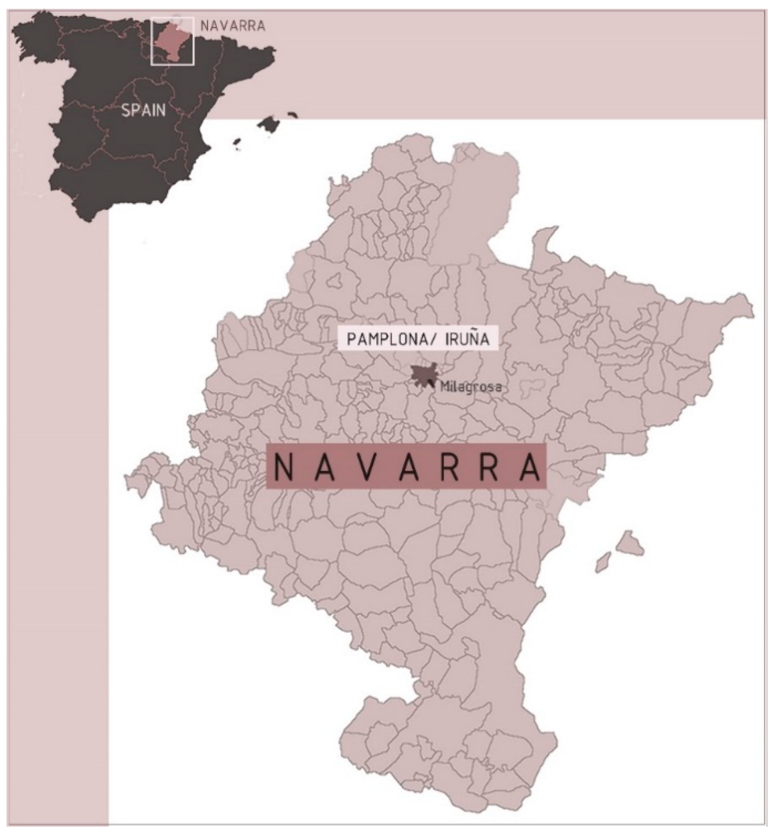
The study area was located in the city of Pamplona (Spain) (
Figure 1). Pamplona is a medium-sized city (203,418 inhabitants), the capital of Navarre and one of the 17 autonomous communities that form the territorial structure of the Spanish state. It is located in the northeast of the Iberian Peninsula, in the centre of a large valley and on the right bank of the Arga River. Pamplona is known as a green city due to its numerous parks and gardens, as demonstrated by the fact that in 2018, the Spanish Association of Public Parks and Gardens rated Pamplona as one of the Spanish cities with the highest proportions of trees and green areas. According to data from the aforementioned study [
47], 14.5% of the municipal surface is covered in green areas so that the urban green surface per inhabitant in some neighbourhoods is higher than 20 m
2 [
23]. What seems to be a very positive situation is not so positive when the internal distribution of green areas is analysed, due to the fact that there are inequalities and strong imbalances between the different neighbourhoods of the city and, above all, areas that are, frankly, disadvantaged, which has generated differences in quality of life [
23].
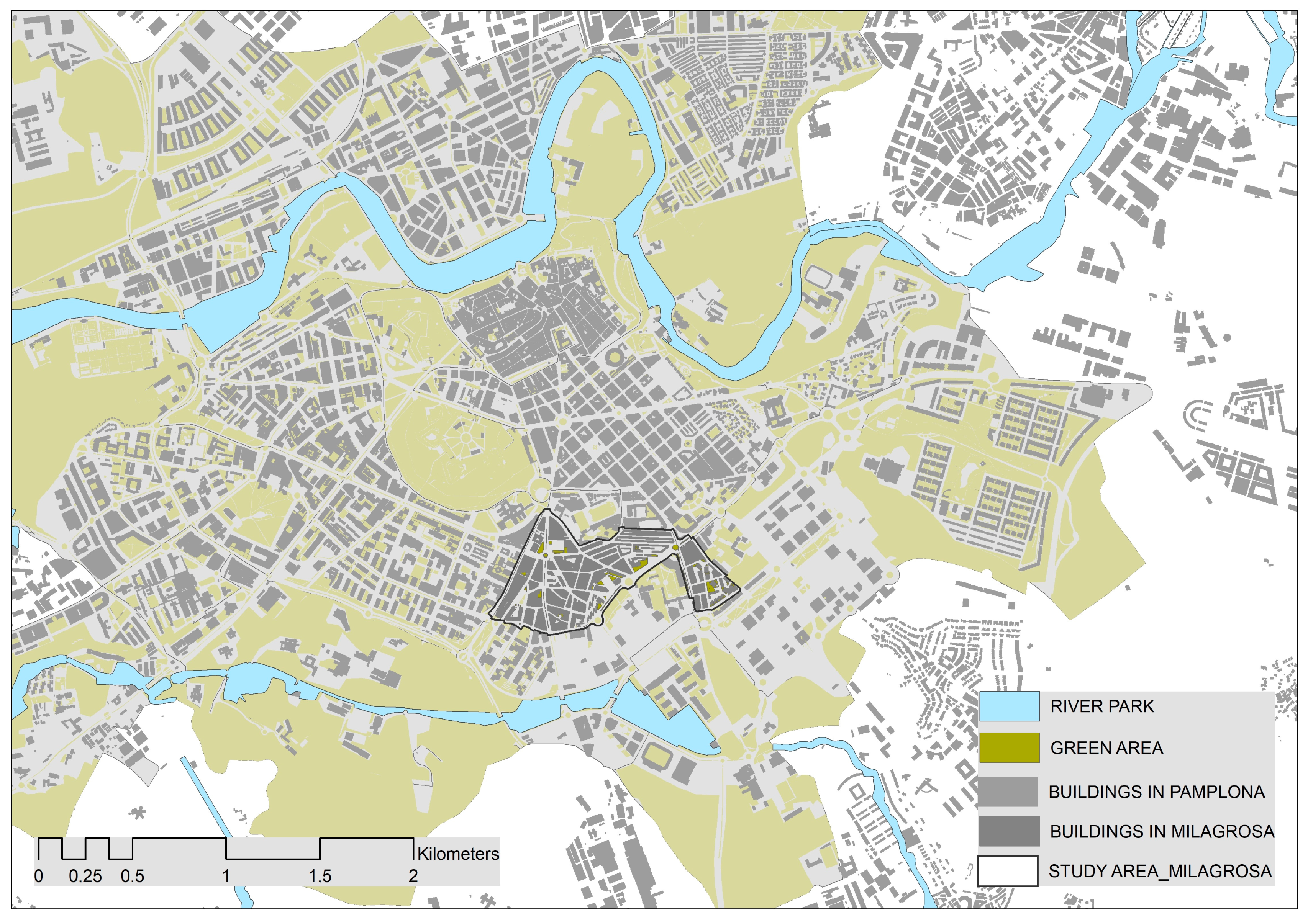
The study area focused specifically on a sector of the La Milagrosa neighbourhood (
Figure 2) in one of the most densely populated and compact areas of the city. The study area corresponded to the historical area of the district of La Milagrosa, i.e., the part built up to the end of the 1970s, and covered an area of 43.7 ha and a population of 14,696 inhabitants. These are a delimitation and a surface that do not take into account the entire surface of the neighbourhood but only the total surface of the areas that form a continuously built environment. This is due to the fact that the study area focused on areas of built-up space and left out green surfaces larger than 1 ha and located on the margins of the neighbourhood—outside the dense and oppressive central space—which conceal its realappearance.
The neighbourhood of La Milagrosa is, in general, the most disadvantaged in terms of greenery. It is located on the southern slope of the city, in spatial continuity with the orthogonal expansion of the early 20th century. It is a working-class neighbourhood of the so-called “first periphery of the centre” [
48], which began its construction in the early 1960s due to the processes of expansion of economic activity and modernisation of industry that began at that time. These processes produced large demographic growth in the cities and, consequently, a pressing residential demand. Within a few years, the urban landscape was transformed in response to a need for massive construction to accommodate large-scale rural migration, and neighbourhoods were built in areas that had hitherto been traditionally agricultural. The urban prevailed over the rural [
48].
This is how the Milagrosa arose, adapted to the slope where the city ended at that time to the south and built on pre-existing rural plots, following the chaotic layout of the roads of that first semi-rural enclave while respecting its existing layout as far as possible [
49]. The road structure is markedly organicist, excessively adapted to the topography and/or existing roads and creating junctions with roads that were left unresolved and have angles that would be very difficult to resolve [
50].
It was built “urgently” on the basis of a spatial and volumetric arrangement that was marked by the new airs that the Modern Movement began, in which building architecture is the exclusive protagonist and the rationalist residential block dominates. Building was the priority; towers and detached blocks were arranged according to orography, sunlight and access [
51] or, inevitably, road space, and, in addition, connections between the different areas of partial development were missing, leaving interstitial spaces without intention or purpose [
50].
In the case of La Milagrosa, the result of this developmental urbanism is a dense [
52] and compact neighbourhood, which has hardly changed since its beginnings and therefore maintains its narrow, irregular, constricted and unconnected streets. Although the notion of a compact and dense city, with a high degree of functional mix, has become a disciplinary paradigm linked to urban environmental sustainability strategies [
53], paradoxically, it is precisely in these crowded neighbourhoods where we found an enormous lack of free space and, consequently, of green space. A compact city restricts the quantity and quality of vegetation, and if it is deprived of green space, that city will become the antithesis of a green city [
19]. It is cars, moreover, that have taken over most of this scarce public space (in La Milagrosa, cars occupy 75% of the surface area) [
54], both in terms of roads and parking. The resulting public spaces are of poor urban quality, leaving minimal space for pedestrians and, of course, for green space. The city was built according to developmental urbanism, which, although it solved the problem of mass housing in terms of housing quality, was a generalised failure from the points of view of urban quality and lack of concern for public spaces [
55].
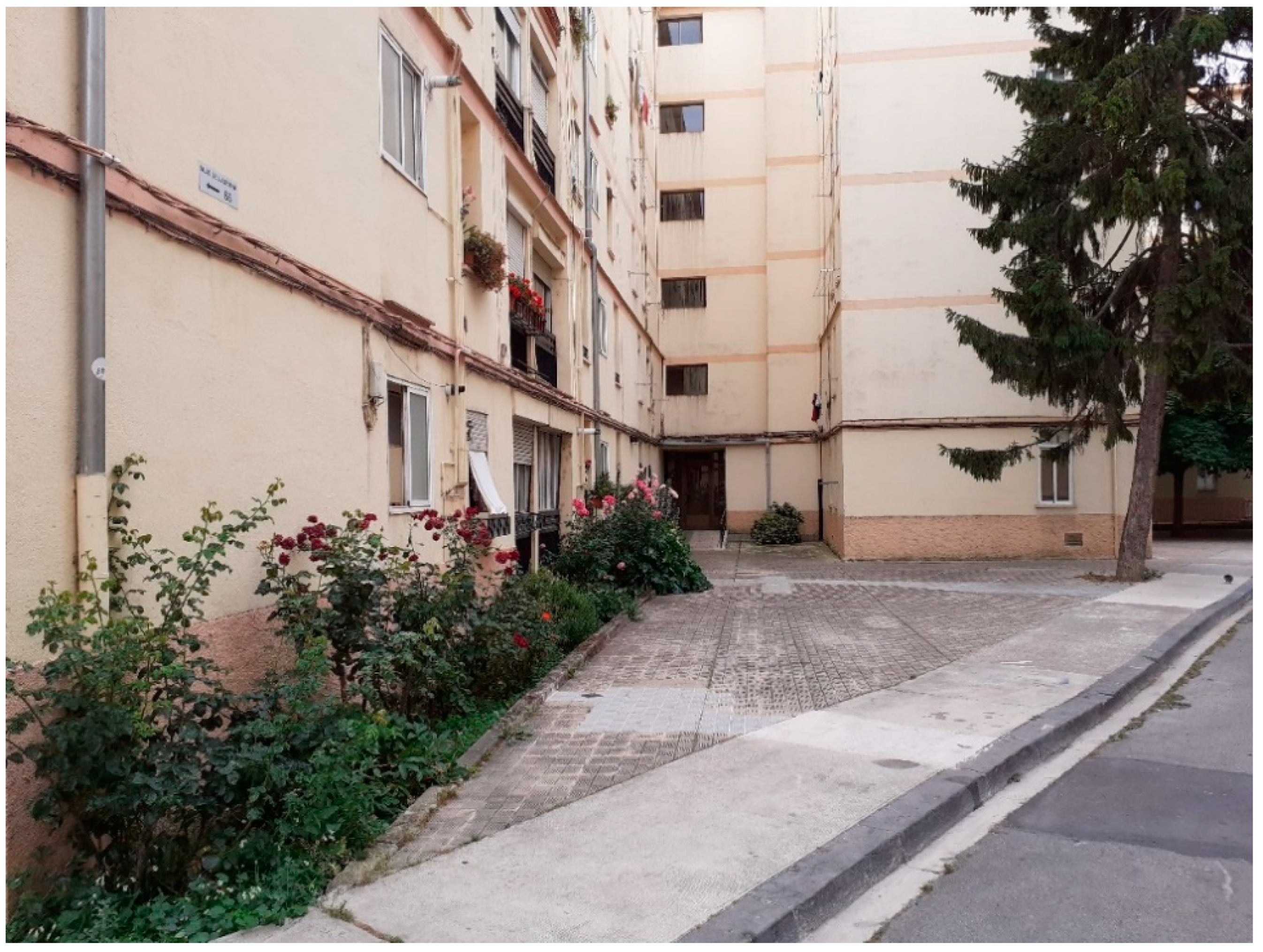
This disorganised configuration of residential estates generated abundant empty and residual spaces that were precisely the starting point for this research, the aim of which was to explore the possibilities they offer for increasing urban greenery, as well as to be able to analyse and understand the possibilities of intervention and transformation of these obsolete neighbourhoods from two different points of view, conservation and renovation, in order to give them a new life for the formation of a new city [
56].
4. Materials and Methods
Although there are numerous approaches and proposals aimed at guiding technicians and experts in identifying elements for elaboration of green-space networks, there is no apparent consensus in the scientific literature on the methodology to map and implement GI [
43,
57,
58]. There are also sophisticated technical methods to assess and identify functionality provided by green areas [
40,
43], the diversity of which is a reflection of the different definitions of GI in the scientific literature and which have led to highly variable assessment methods and results [
57]. On the other hand, the lack of integrated approaches that address ecological and environmental benefits alongside human wellbeing is frequently criticised by scholars [
59]. This problem is particularly critical in urban spaces with regard to IGU planning. In relation to the Mediterranean area, Delgado and Cariñaños (2020) [
40] concluded that the current picture is defined by a lack of standardised and manageable frameworks, for all involved stakeholders, aimed at promoting IGU identification. However, perhaps one of the methodological gaps with the greatest repercussions is the one recently confirmed by Brzoska and Spage (2020) [
60], based on a systematic literature review that analysed, among other aspects, the scales of study in research on green infrastructure and urban ecosystem services. In summary, the authors found that there is still a gap in assessment methods on local urban scales. According to them, the majority of work still focuses on larger spatial structures, mostly applying generalizing methods that provide results with a poor fit to reality. They concluded that there is a need for spatially comprehensive research on urban green spaces, including settlements and built-up areas, and thus the small green spaces and structures they contain so that they can be taken into account in designing ecological and sustainable cities. As Boehnke et al. (2022) [
10] pointed out, in many cities, there are large areas that lack urban forests or large green spaces. Instead, these areas are characterised by small-scale mosaics and private greenery, consisting of roadside trees or greenery, individual trees, hedges, flower beds, gardens or lawns. All these types of element and space can only be inventoried and mapped through means of local mapping procedures that reach a level of detail that is not usual, e.g., mapping via remote sensing. Finally, in addition to the problems outlined above, there is a lack of research attention to the study of possibilities of designing and implementing green infrastructure according to the particularities of urban morphology, especially when renaturation of cities has become a priority objective to increase their resilience and their adaptation to climate change.
This research used a qualitative method that combined identification and mapping (inventory) of green spaces in the study area and in situ analysis of the morphology and the urban space in order to characterise and typify the residual spaces in the urban fabric that could host SUGSs. This research aimed to reflect on the way in which the errors of an inadequate urbanisation model can be converted into opportunities for restoration and inclusion in the network of urban green spaces.
A manageable protocol for identifying and categorising small urban green areas was created on a detailed scale to establish practical alternatives and solutions, to maximise opportunities for vegetation [
19] and to enable renaturation of compact areas so that they could provide a reasonable quantity and quality of vegetation to improve the hostile environment and thus people’s quality of life. The Milagrosa neighbourhood was taken as a case study, as a representative of a small-sized, dense and compact neighbourhood.
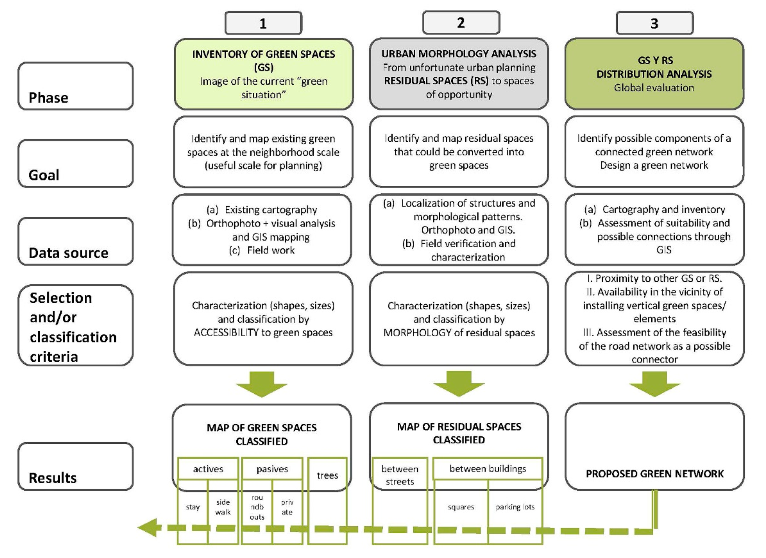
The methodological proposal was developed in three consecutive phases (
Figure 3):
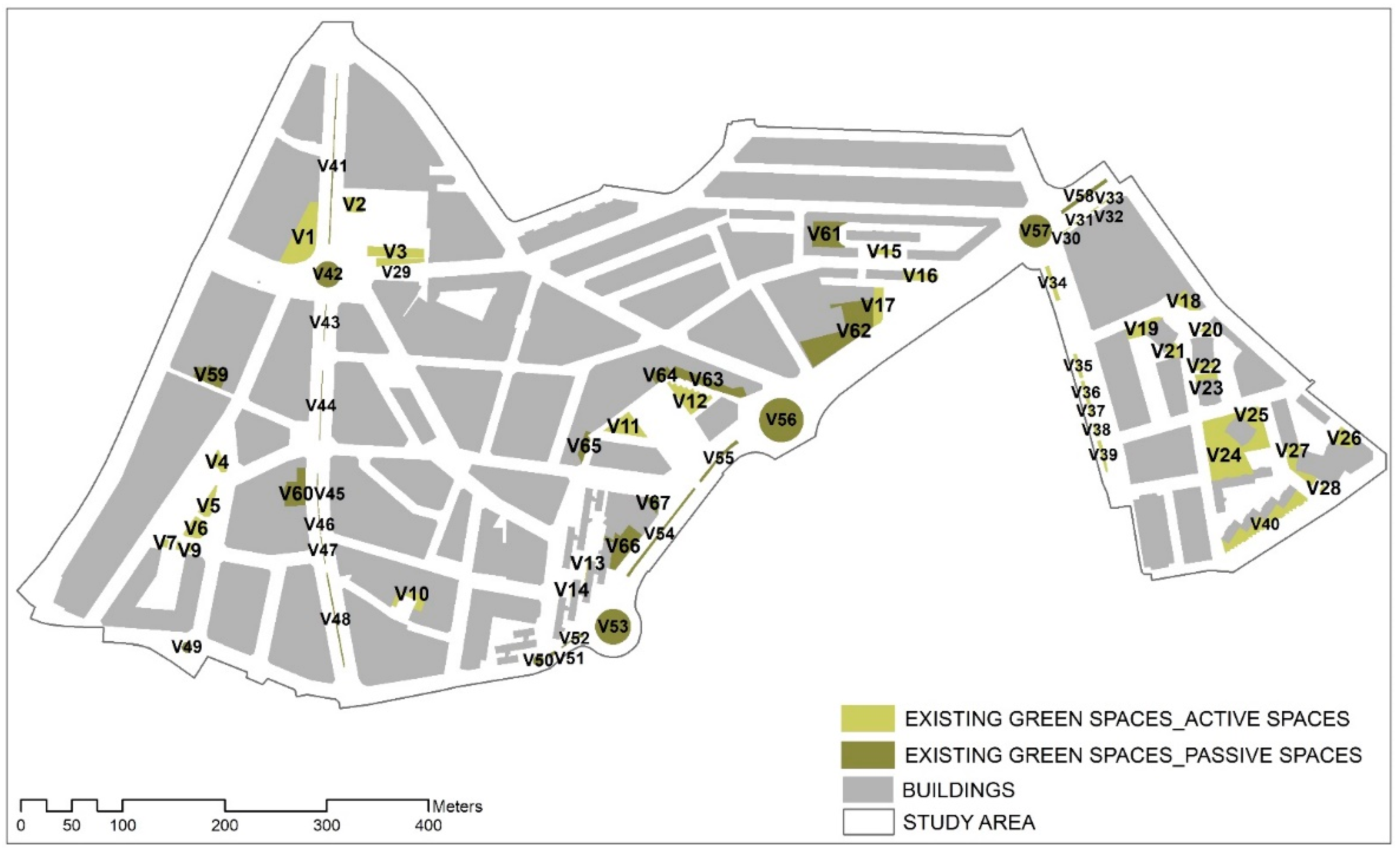
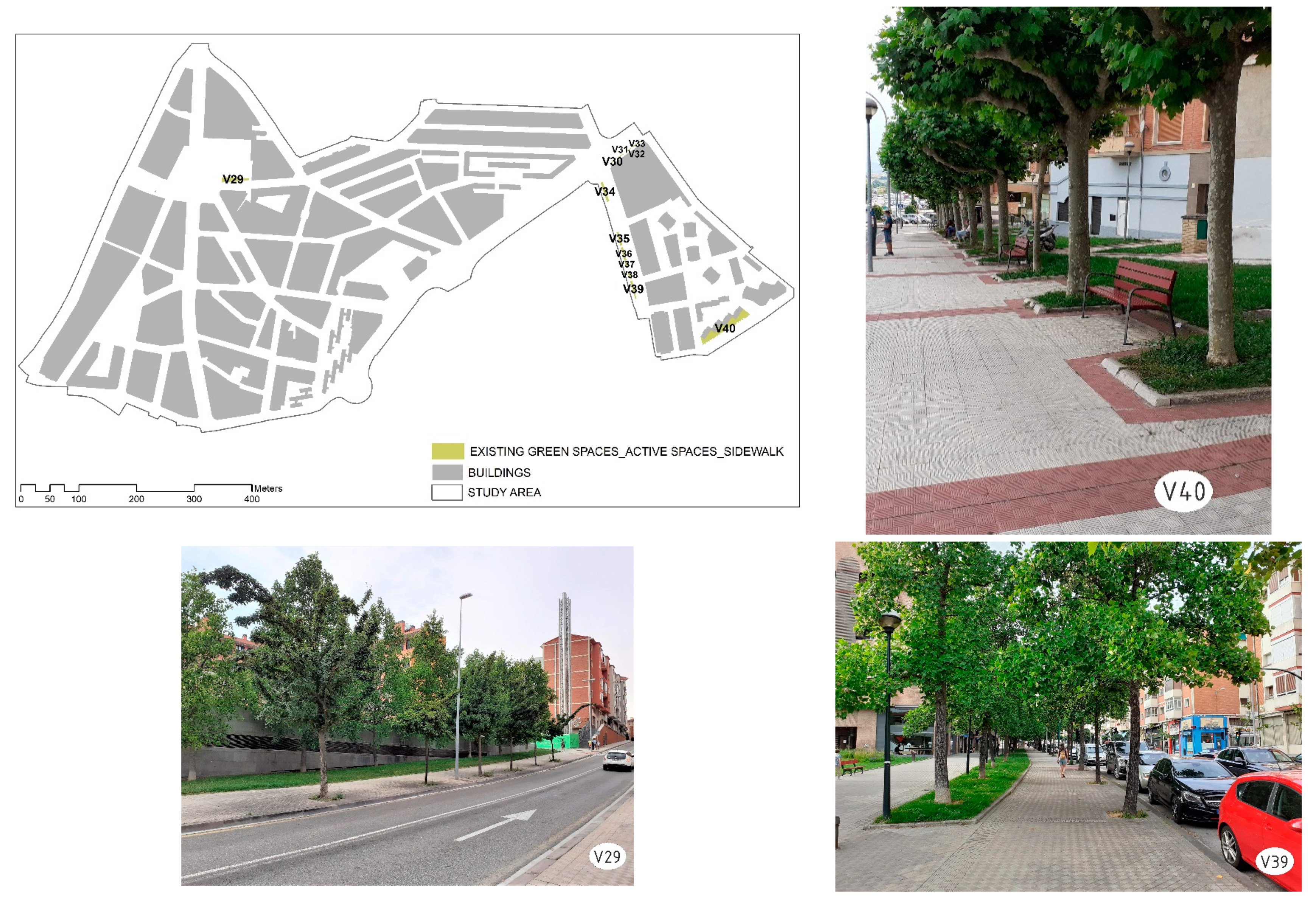
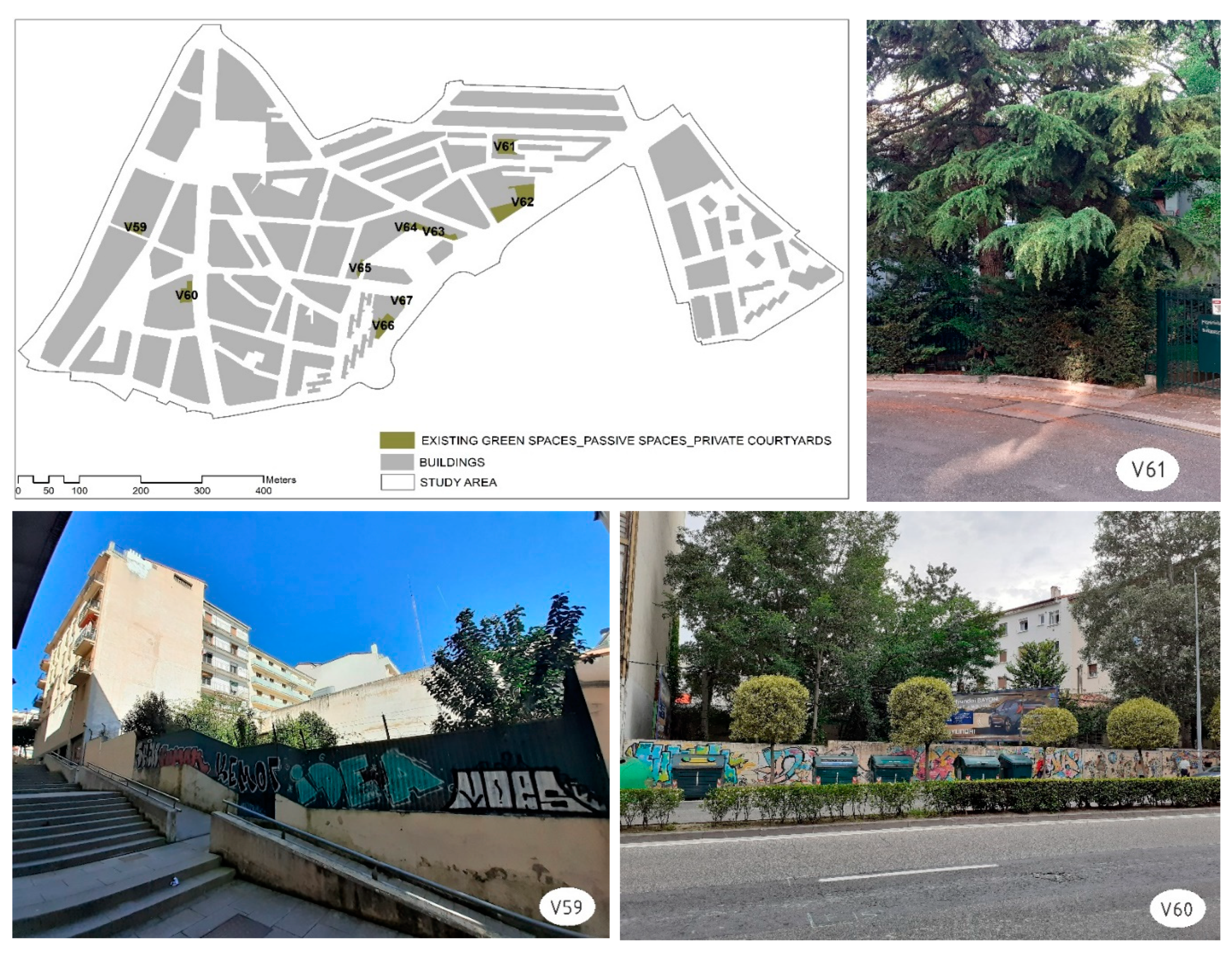
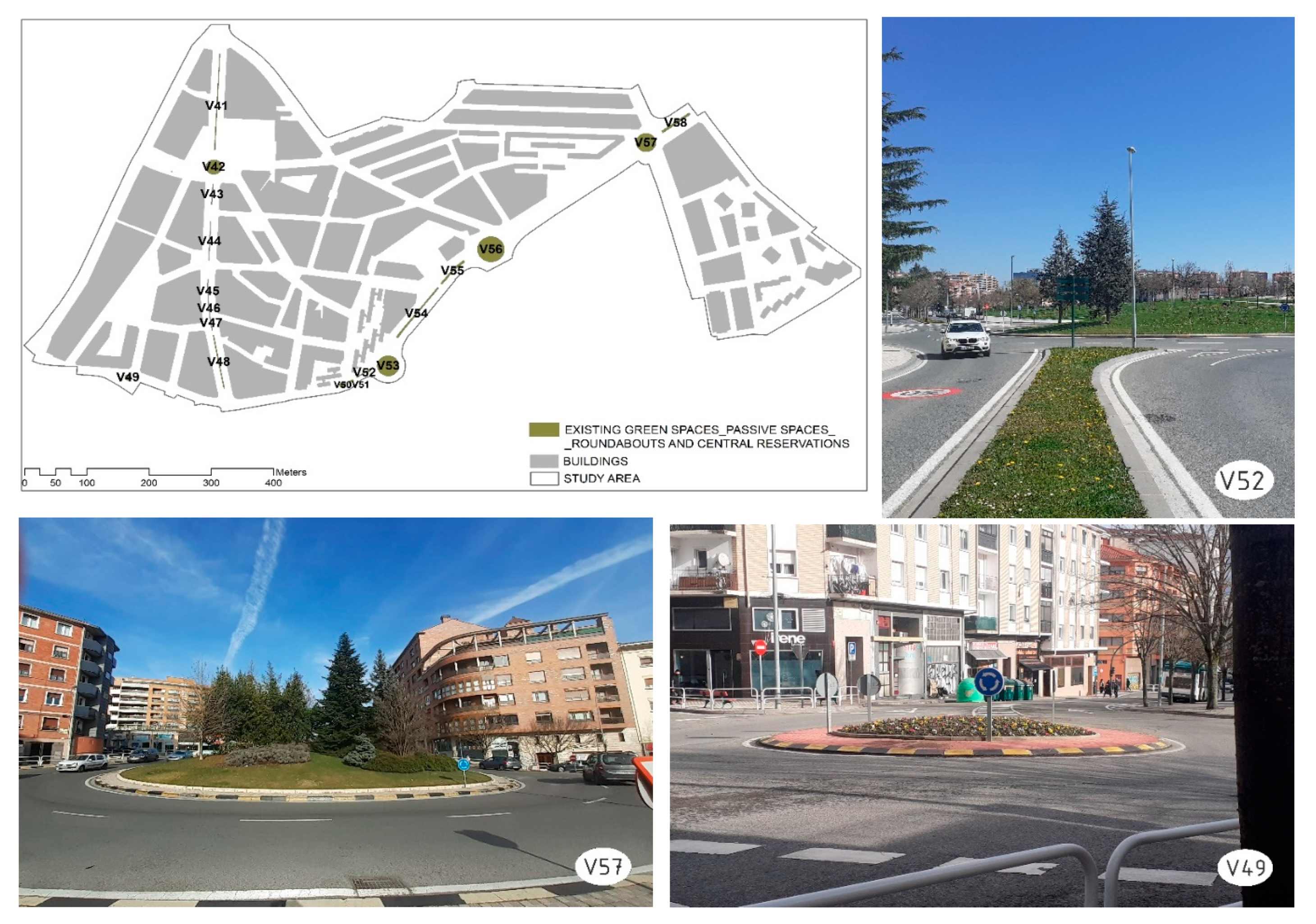
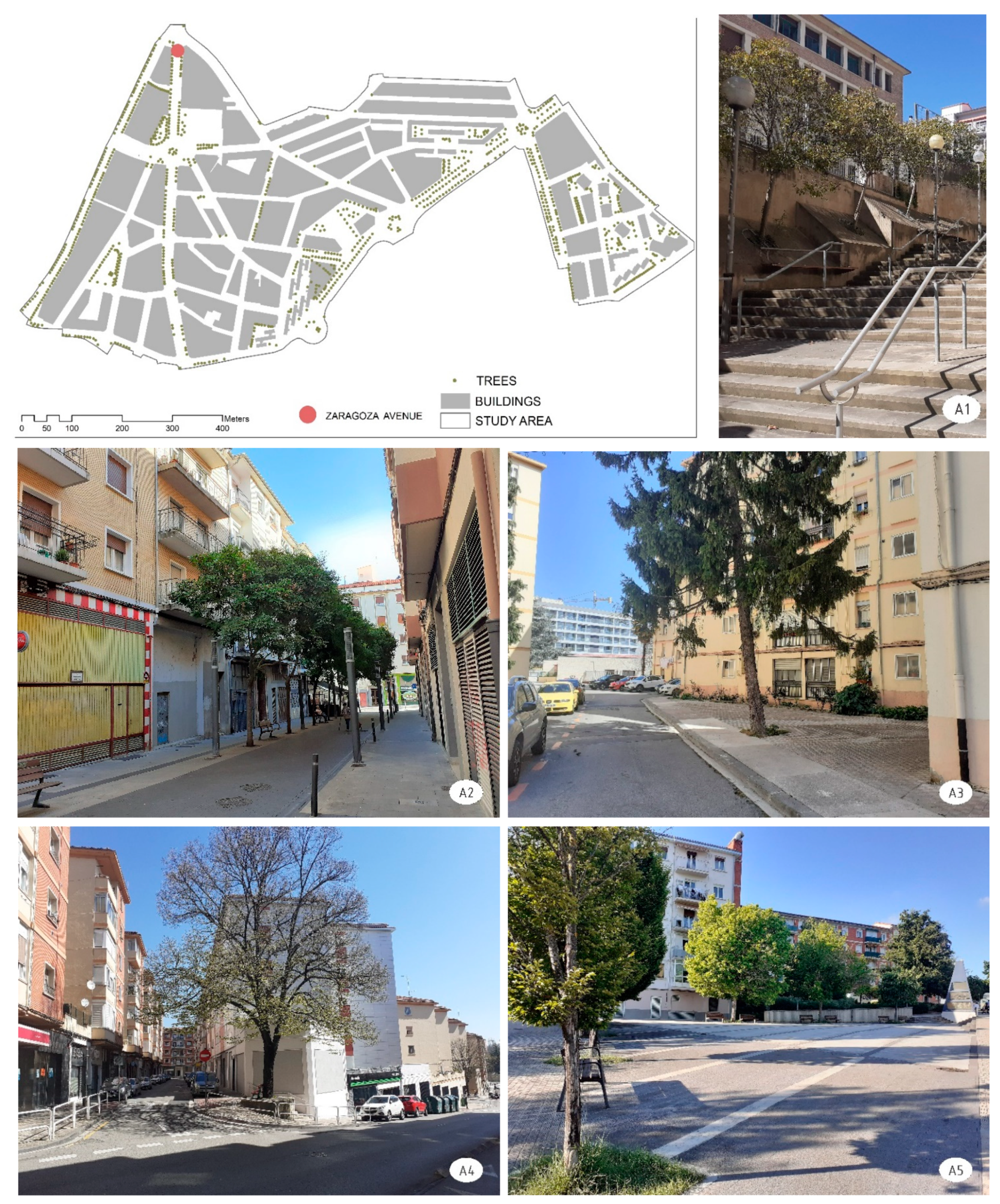
In the first phase, a detailed inventory was made of all urban spaces with some type of vegetation (herbaceous, shrub or tree) in direct contact with the ground, regardless of the size of the space or its ownership. The digital cartography of gardens owned by the City Council of Pamplona has been used as an initial source of information; this was completed with the cartography produced by NASUVINSA for the study Green Infrastructure Pamplona Area and Surroundings, which was provided by the company. Finally, the information was completed with digitalisation using ArcMap software based on exhaustive field work and the municipal 2020 orthophoto scale 1/500.
The existing green spaces were classified on the basis of the possibilities of interaction they offer, active or passive, depending on whether they are accessible for carrying out some type of activity (active) or whether, being inaccessible, they fulfil functions fundamentally of contemplation (passive) and will be essential for future connectivity objectives. Within the active spaces, a distinction was made between those that allow people to stay or meet socially and those that accompany urban routes, fundamentally providing aesthetic and visual values.
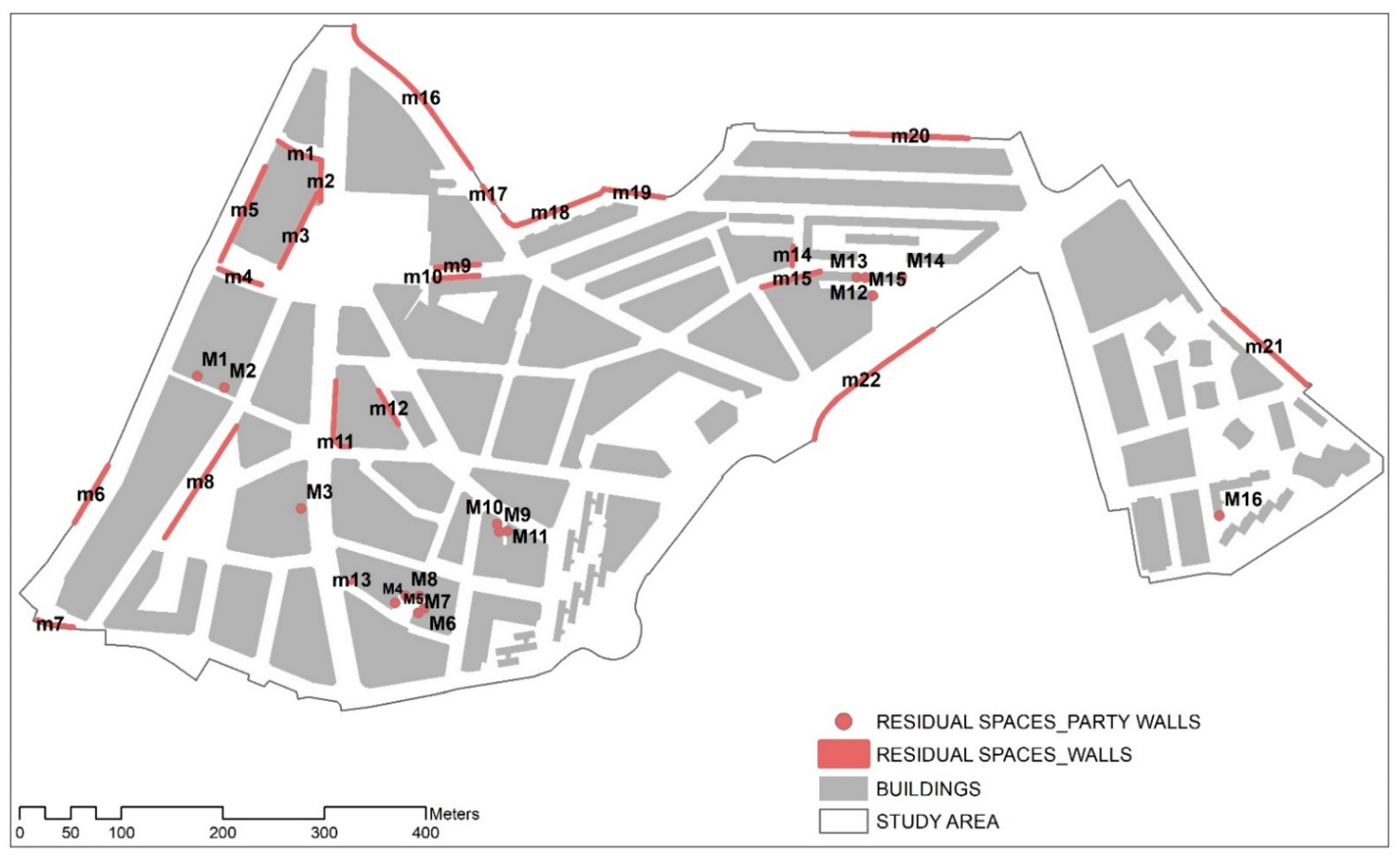
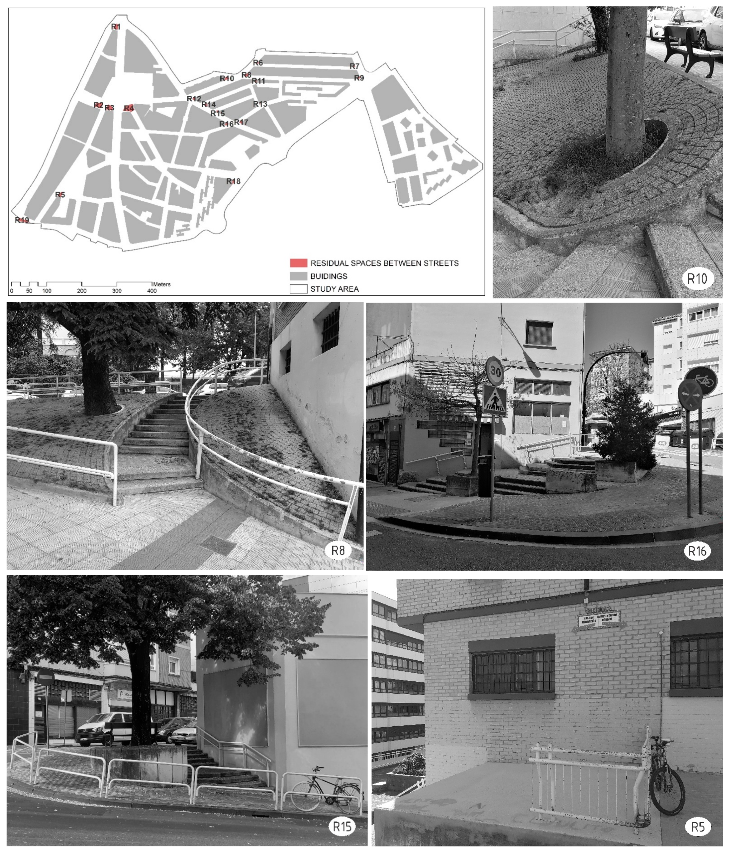
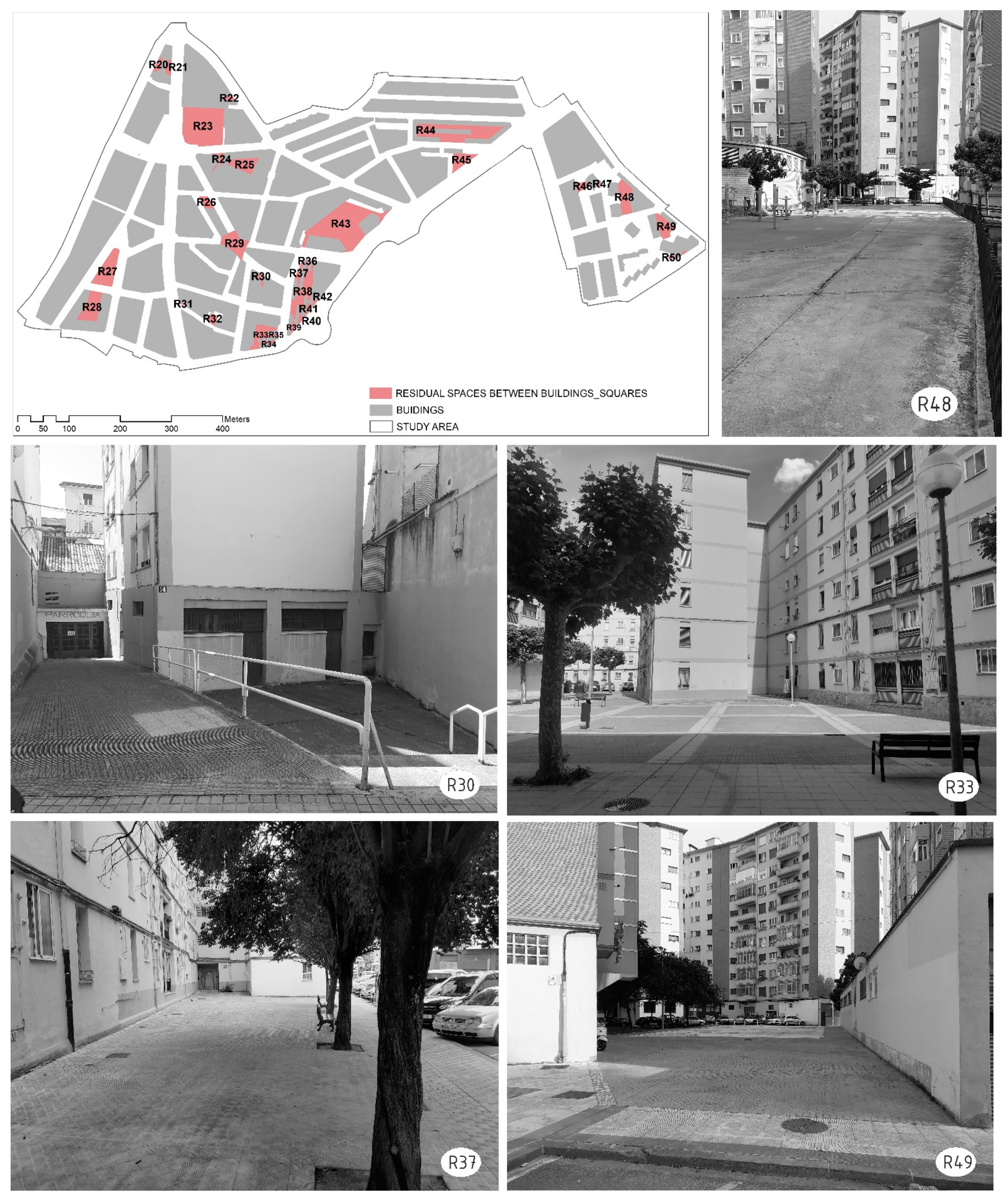
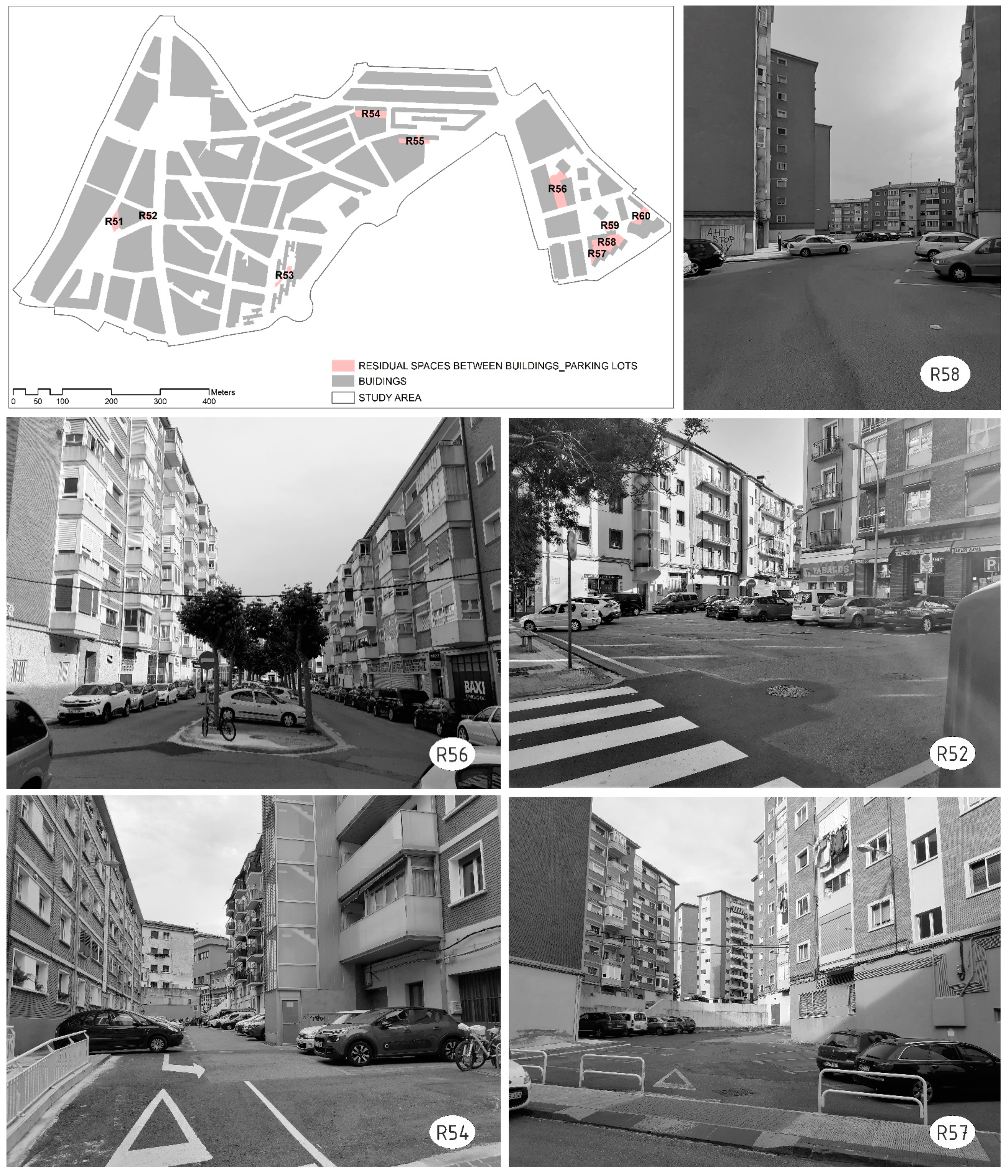
In the second phase, a detailed analysis was carried out, using orthophotography, of the urban fabric in order to identify the residual spaces generated in developmental urbanism, which prioritised building and left urban space as a mere result, creating interstitial spaces without intention or purpose. Although urban residual spaces have always existed, as they are inherent to city transformation processes, there is no clear concept of them and there are numerous expressions used to mention them [
31]. For the purposes of this paper, we will use, as a concept of residual spaces, the generic description proposed by Lauria and Vesella [
31]: they are places considered devoid of or lacking specific qualities that offer city dwellers multifunctional opportunities that they are not usually provided—walking, resting, meeting up, chatting, playing, etc.—considering, in addition, that they contain some potential opportunity, “marketable” to a greater or lesser degree, and that it would be a mistake to consider them useless or unusable places (2021:29). On the issue at hand, as Jim (2004) [
19] pointed out, even the smallest gardens could create interesting ecological diversities and attract both wildlife and human visitors. It is the residual planted sites that Jim (2004) [
19] referred to, as pieces often omitted in formal but piecemeal greening projects, that could be systematically enlisted into the green network. After the mapping and analysis of the residual spaces, each of them was visited to collect complementary information and obtain photographs that would serve as the basis for renaturation designs.
In the third phase, the distribution, characteristics and possibilities of naturation of the identified residual spaces were analysed in order to assess the possibilities of creating a small green network on a neighbourhood scale through linking/connecting the different types of spaces. The greater or lesser abundance of residual spaces was combined with information on urban fabric for selection of the most suitable network segments. Once the network was selected, the aim was, as Lauria and Vessella (2020) [
61] pointed out, to design and carry out a set of microscale actions with a positive effect wider than their range of action, mainly due to their conception as a network of SUGSs that provides connectivity and can become a strategy for urban regeneration [
29]. This proposal is based on the consideration of SUGSs as a sort of ally for urban sustainability in the sense that they allow for creation of dense urban spaces while offering communal, socialising spaces as an alternative to large parks [
62]. At the base, the complementarity and relational continuity between urban hubs, typical of the network model of pocket-park systems [
59], was also an objective in this case.
6. Discussion
The results of this research confirmed that in compact urban spaces, the possibility of introducing and expanding green areas is indeed limited, and it can be complex or even impossible to reach standards. A previous study [
23] already showed that the study area of La Milagrosa has a ratio of 2 m
2 of green space per inhabitant compared to the average for the city of Pamplona, which is 12.9 m
2. This is a calculation of green areas that was made while taking into account all the small spaces that are covered in some type of vegetation. It therefore incorporates spaces that have been detected in microscale analysis and are not common in the inventories of urban green spaces [
10,
60]. Nevertheless, this figure falls far short of the 9 m
2 recommended by the World Health Organisation [
65]. Undoubtedly, the almost 560 m
2 of UGS per inhabitant of the city of Ljubljana, Slovenia (awarded the 2016 European Green Capital), is excellent from the points of view of urban ecology, health and quality of life. However, as we have pointed out on other occasions [
23], given the delicate balance between densification and greening, we agree more with the approaches of those who advocate not so much for the quantity of green spaces as for their quality [
1,
8,
15,
19,
20].
Microscale analysis of residual areas in the study area, looking for opportunity spaces to increase green spaces, detected a surface area, which could be greened, that is twice the size of the existing green spaces. If the greening procedures for residual areas were implemented, the ratio of green spaces could be increased to 4.3 m2 per inhabitant. However, beyond the figures and ratios, we consider it important that if this greening were to be carried out, (a) a green corridor could be created, running through the neighbourhood of La Milagrosa, and (b) a set of green squares, which would also serve as meeting, socialization and psychological restoration spaces, could be generated. In any case, the results proved that there is potential space for increasing green areas and, above all, for creating corridors that allow environmental and social connectivity within the neighbourhood itself and between it and the rest of the city. These corridors could provide the neighbourhood with pleasant, healthy routes and encounters with a natural environment.
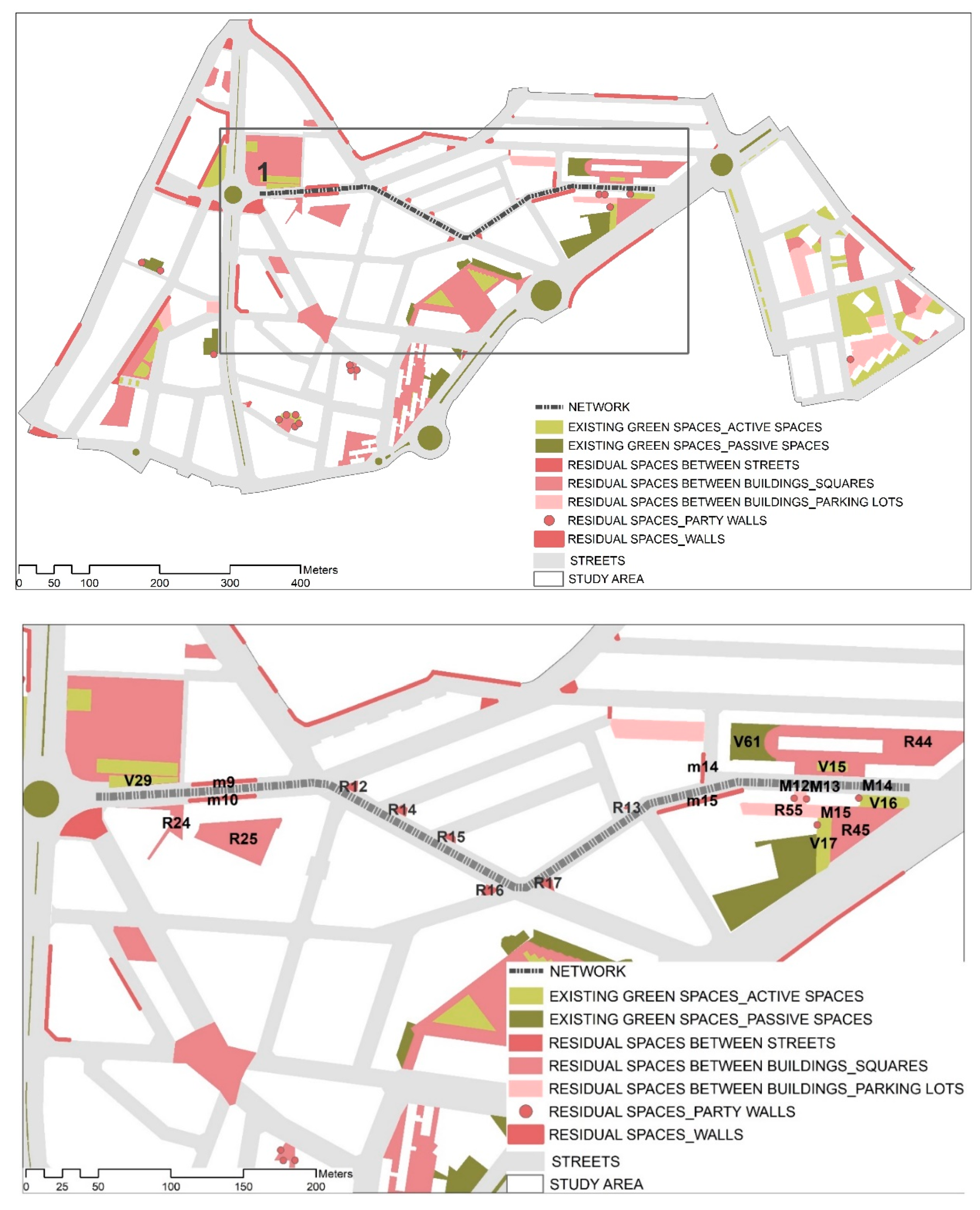
The creation of such a green corridor is a solution, but it is also a complex task. Creating the green corridor would require a strong political will on the part of the city council, where the departments in charge of urban planning and those in charge of parks and green spaces do not communicate well with each other. However, it would also require contact with the resident population in a participatory and educational formative process that would make it possible to get to know the residents’ ideas about their neighbourhood and its ecology while trying to make the population aware of the advantages and opportunities of improving their quality of life through green spaces and green corridors. Research is now moving forward along these lines, preparing a participatory process for which the proposal of green spaces and corridors has been created, as shown in
Figure 19 and
Figure 20.
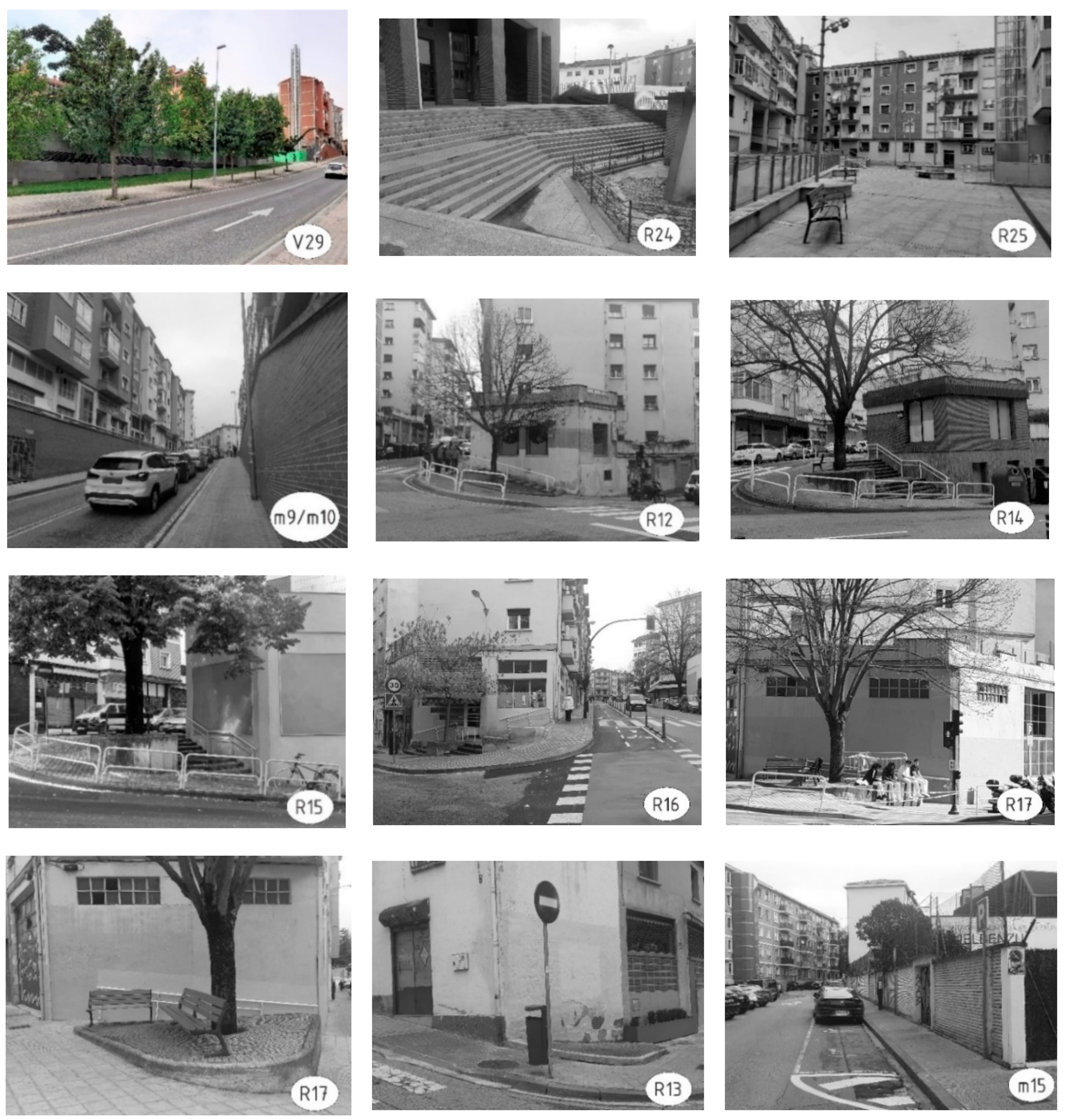
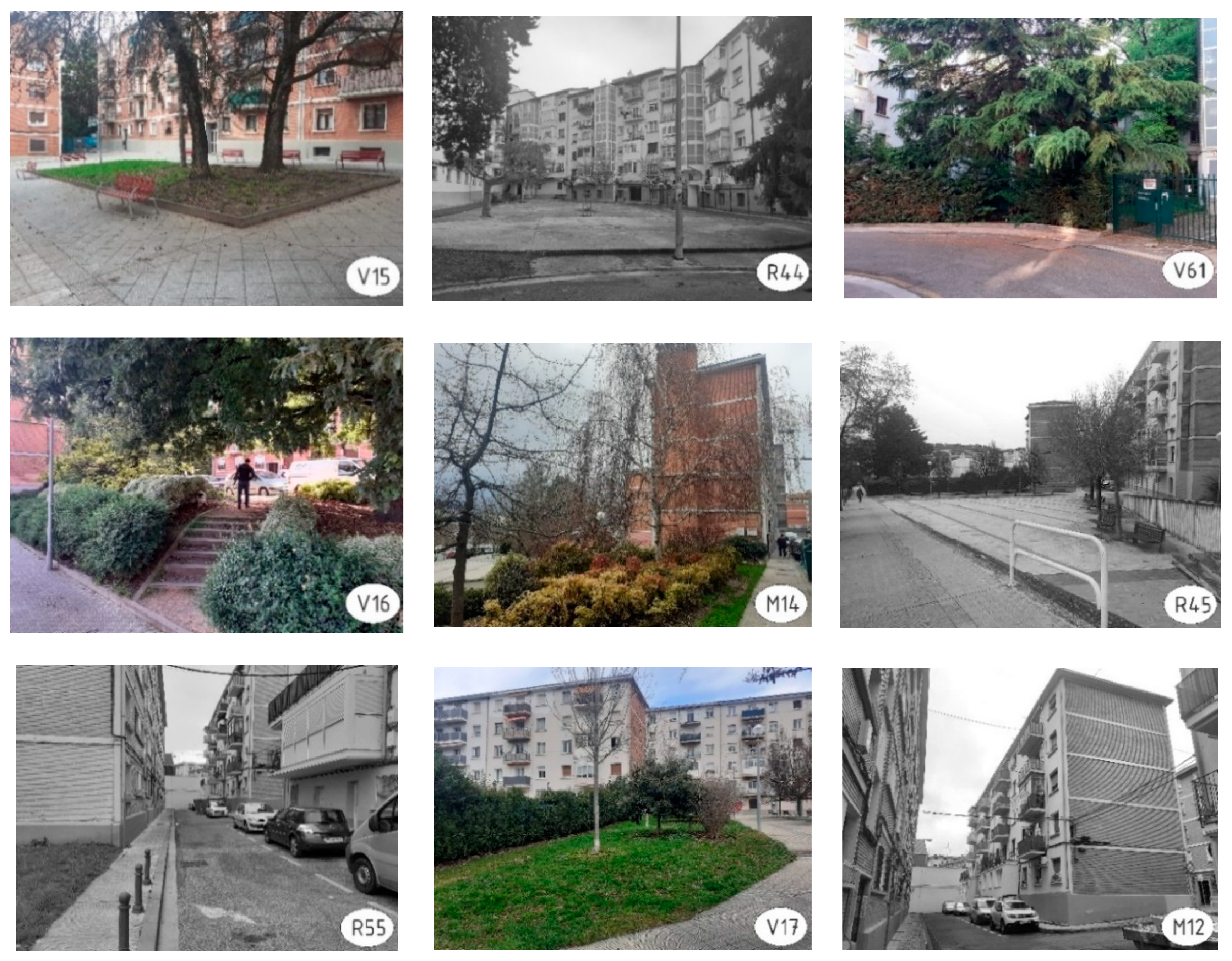
Figure 19 shows the layout of a fragment of the ecological corridor, identified as 1. As an example and a visualisation of the corridor components and spaces,
Figure 20 shows the sequence of images corresponding to the spaces (existing green spaces + residual spaces) that would be greened and/or landscaped to form a connected network of SUGSs.
Another issue that we consider important is the fact that the analysis carried out provided information and arguments to fuel debate and reflection on the possibilities and limitations of greening of compact urban areas. It also showed that there are urban areas in which, far from needing densification, there is a need to reduce the built-up area. In these compact spaces, it could be positive to reduce density, opening up space via possibly removing some built-up areas. This has been attempted in La Milagrosa, where the city council proposed the demolition of several residential buildings (190 dwellings). The municipal proposal was met with strong rejection and opposition from the population, which led the city council to reject the proposal.
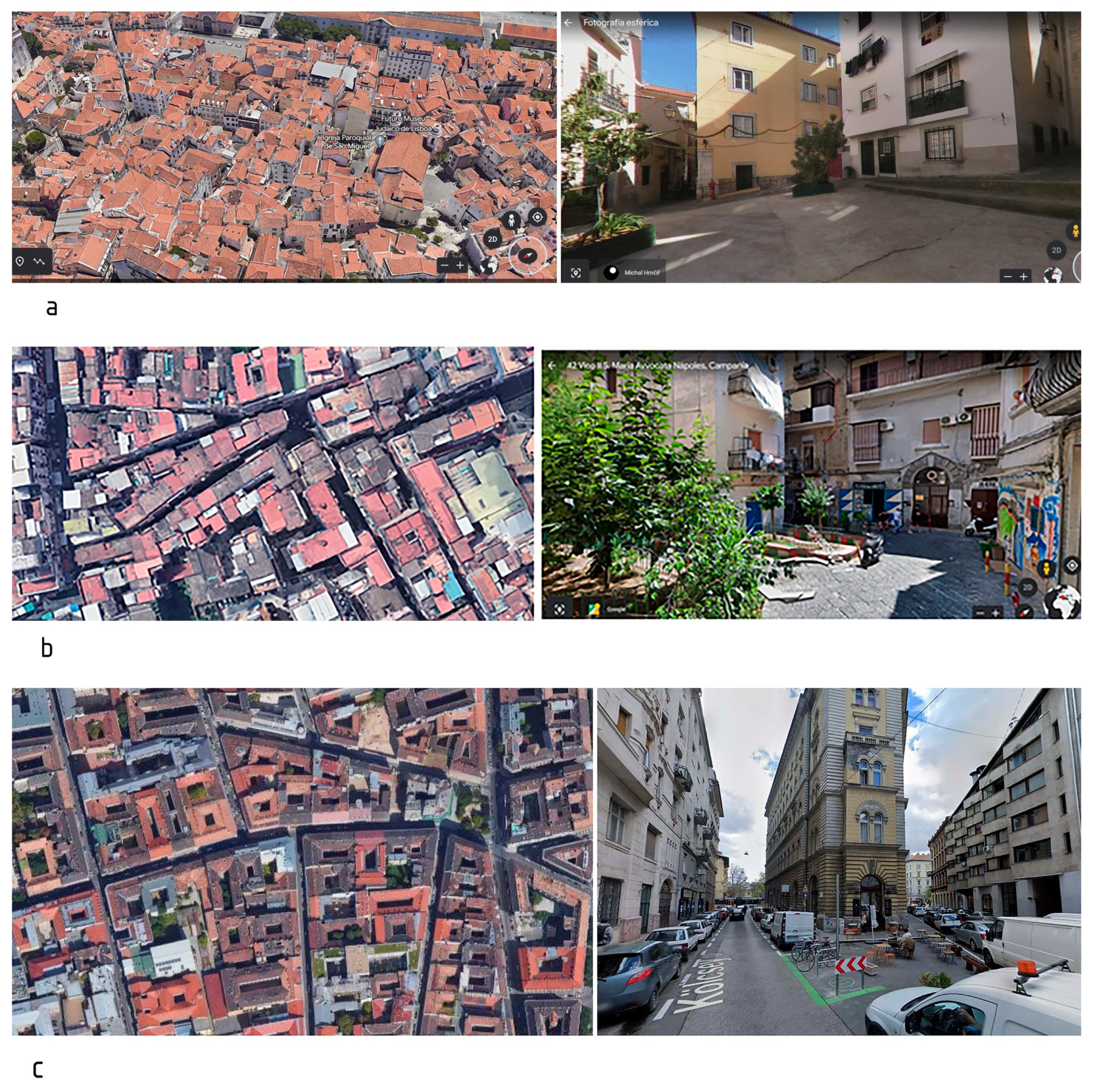
Finally, we considered that the type of analysis carried out in La Milagrosa could be a starting point for advancing approaches to the possibilities of residual spaces in greening and creation of urban green infrastructure. The organizational structures of the buildings of La Milagrosa and the scarcity of green spaces it presents, both fruits of the aforementioned developmentalist urbanism, are frequent in the neighbourhoods of many European cities that have welcomed the migratory waves produced by different causes at different times in their history: rural migration that allowed urban industrialization in some cases and migration from other countries in other cases. In most cases, these are neighbourhoods inhabited by the working classes and, in general, by the low-income population. Neighbourhoods of this type are present in most of the world’s cities, even in those that have green spaces that allow them to boast or show off, such as in the city of Pamplona. Intraurban inequalities in distribution of green spaces and the relationship between socioeconomic level and quantity and quality of urban greenery are well-documented in research on the subject. In Europe, the European Environment Agency published in 2022 [
26] a report in which it echoed the inequity common in many European cities regarding availability and access to green areas from different residential areas. The report included studies carried out, for example, in the cities of Debrecen and Bucharest (Hungary), Warsaw (Poland), Berlin (Germany), Turin (Italy), Helsinki (Finland), Bucharest, Lisbon and Porto (Portugal), showing the most unfavourable conditions of green spaces—or simply their scarcity—in neighbourhoods inhabited by the lower social classes. During the last few years, fortunately, some of these neighbourhoods have undergone profound reform and improvement processes, to the point of becoming highly desirable and even gentrified residential areas. The neighbourhoods of Arroios and Alfama (former fishermen’s quarter) in Lisbon, Punavuori in Helsinki or District 8 in Budapest are examples of this process. Nevertheless, there is still much room for improvement in most of these cities in terms of increasing green spaces. This was the conclusion of a study published in 2021 by the Institute for Global Health (ISGlobal) (Barcelona, Spain) [
66], in which they detected overmortality linked to high density and scarcity of green spaces in different European cities. A virtual visit using the Google Maps Street View tool allowed us to discover, in these neighbourhoods, residual spaces very similar to those located in La Milagrosa (
Figure 21).


