
Combining Spatiotemporally Global and Local Interpolations Improves Modeling of Annual Land Surface Temperature Cycles


 ,
,
Abstract
1. Introduction
2. Study Area and Data
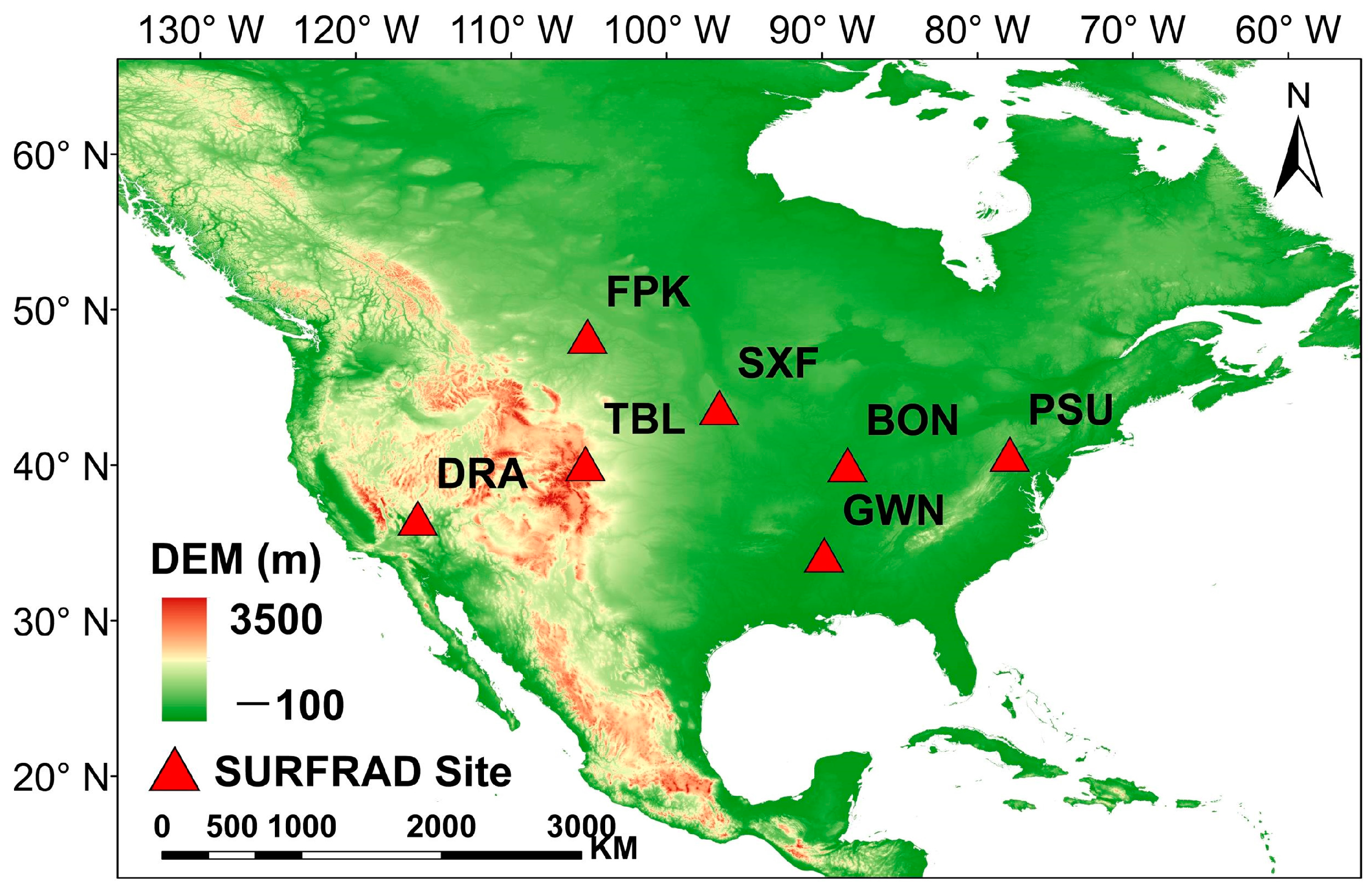
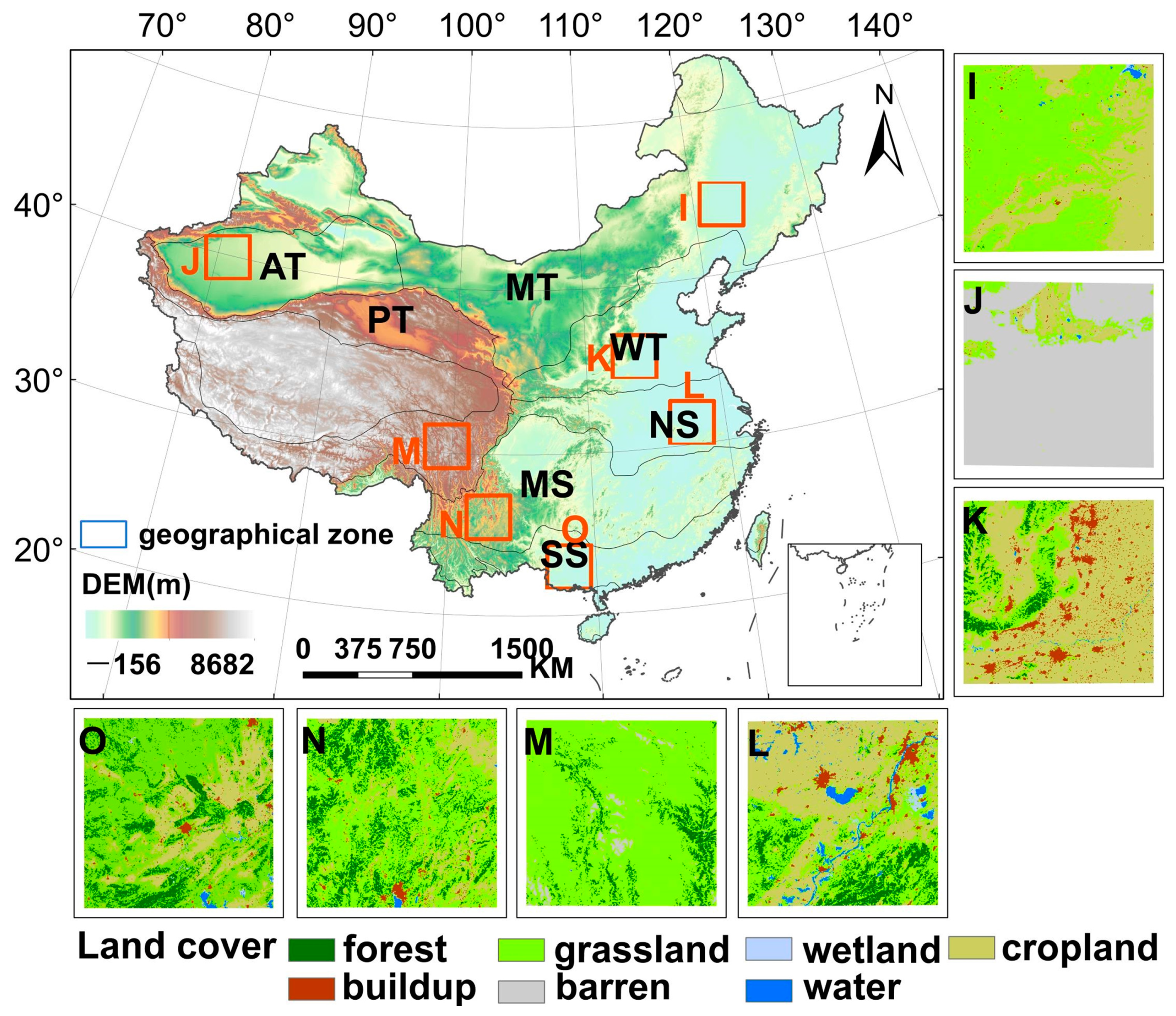
2.1. Study Area
2.2. Data
2.2.1. Satellite Data
2.2.2. In Situ Measurements
2.2.3. Auxiliary Data
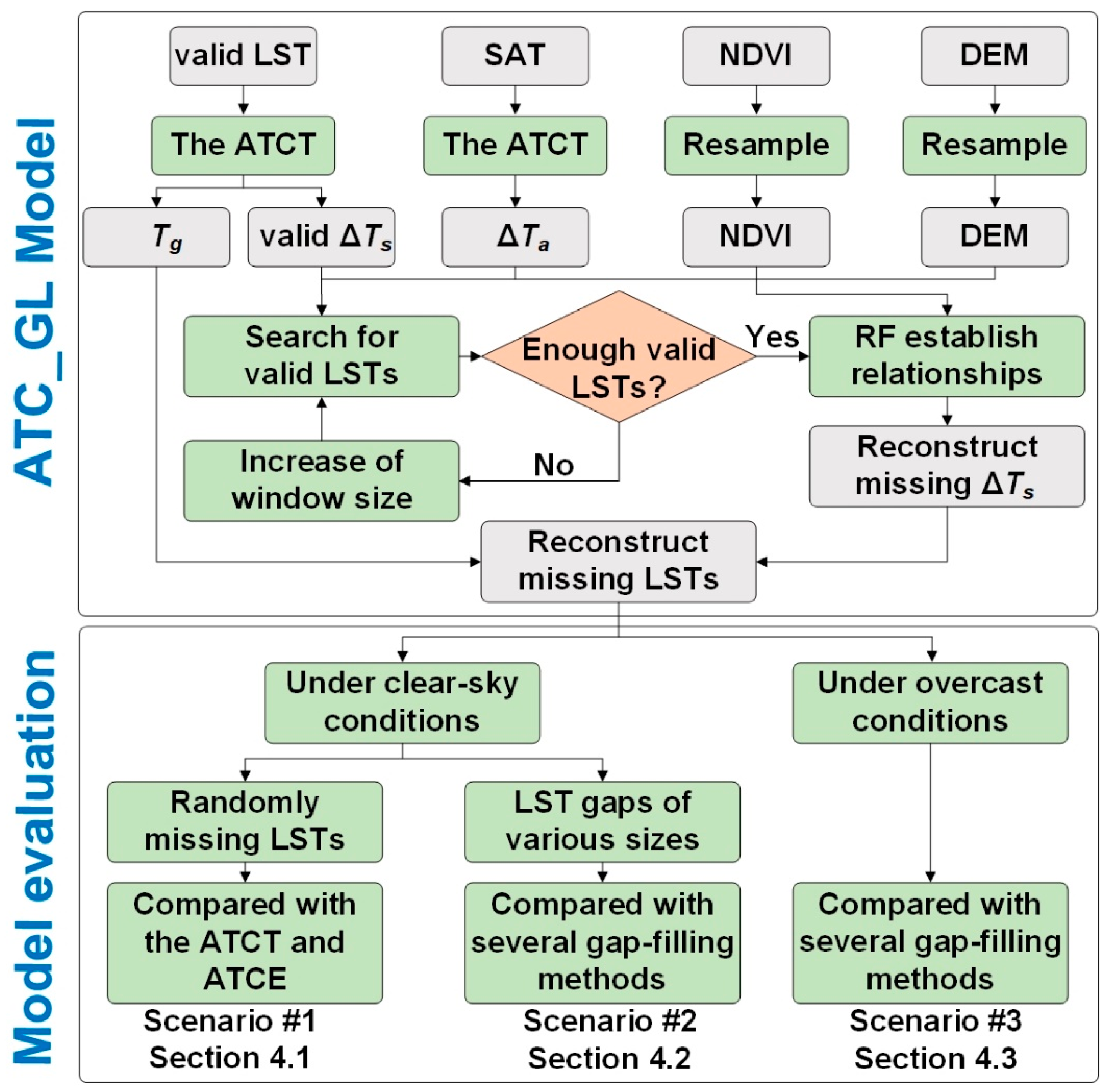
3. Methodology
3.1. Modeling of Intra-Annual Land Surface Temperature Dynamics by Combining Spatiotemporally Global and Local Interpolations
3.1.1. Reconstruction of Seasonal LST Cycle at the Temporally Global Scale
3.1.2. Reconstruction of Daily LST Fluctuations at the Spatiotemporally Local Scale
3.2. Evaluation Strategies
4. Results
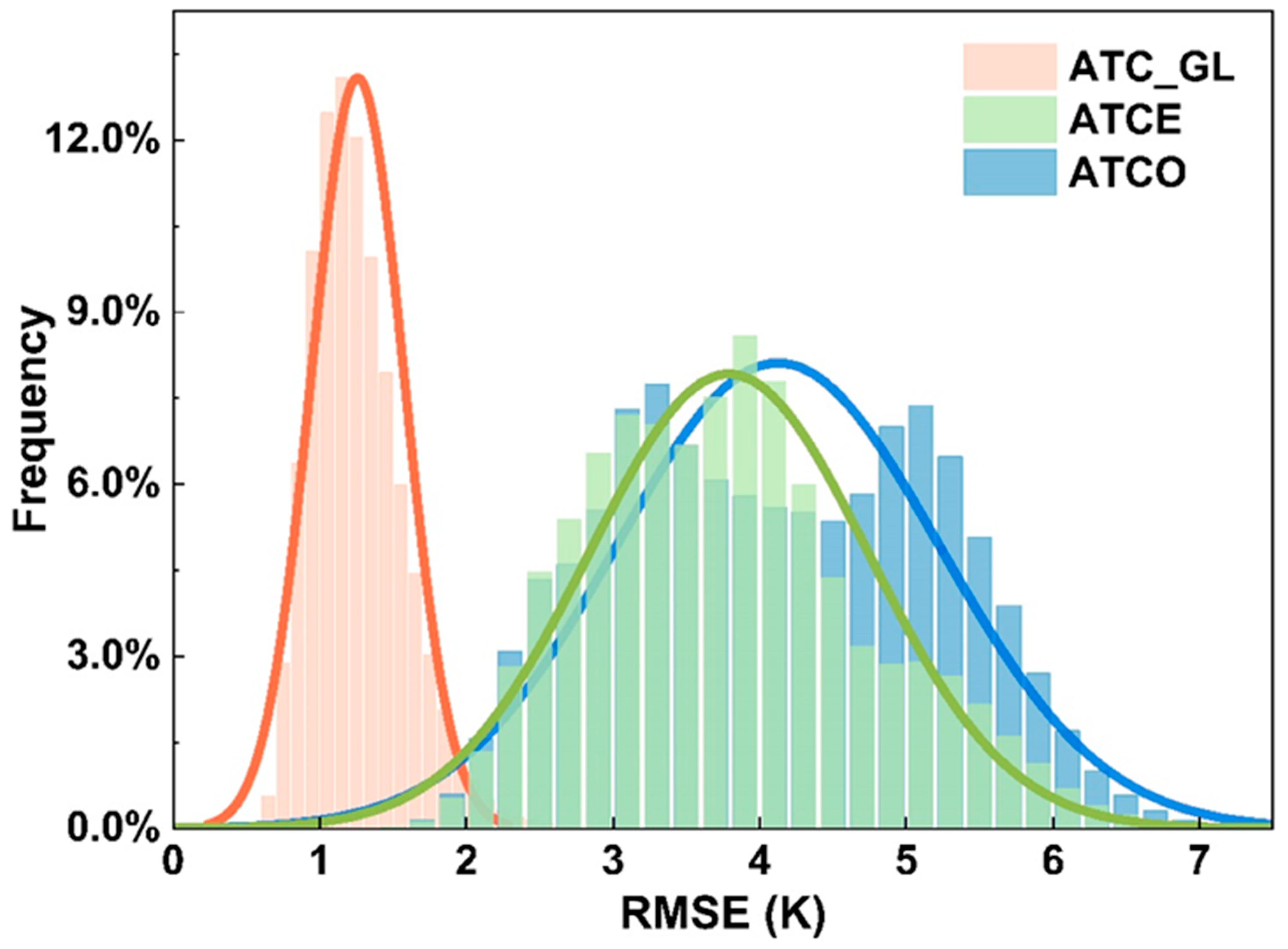
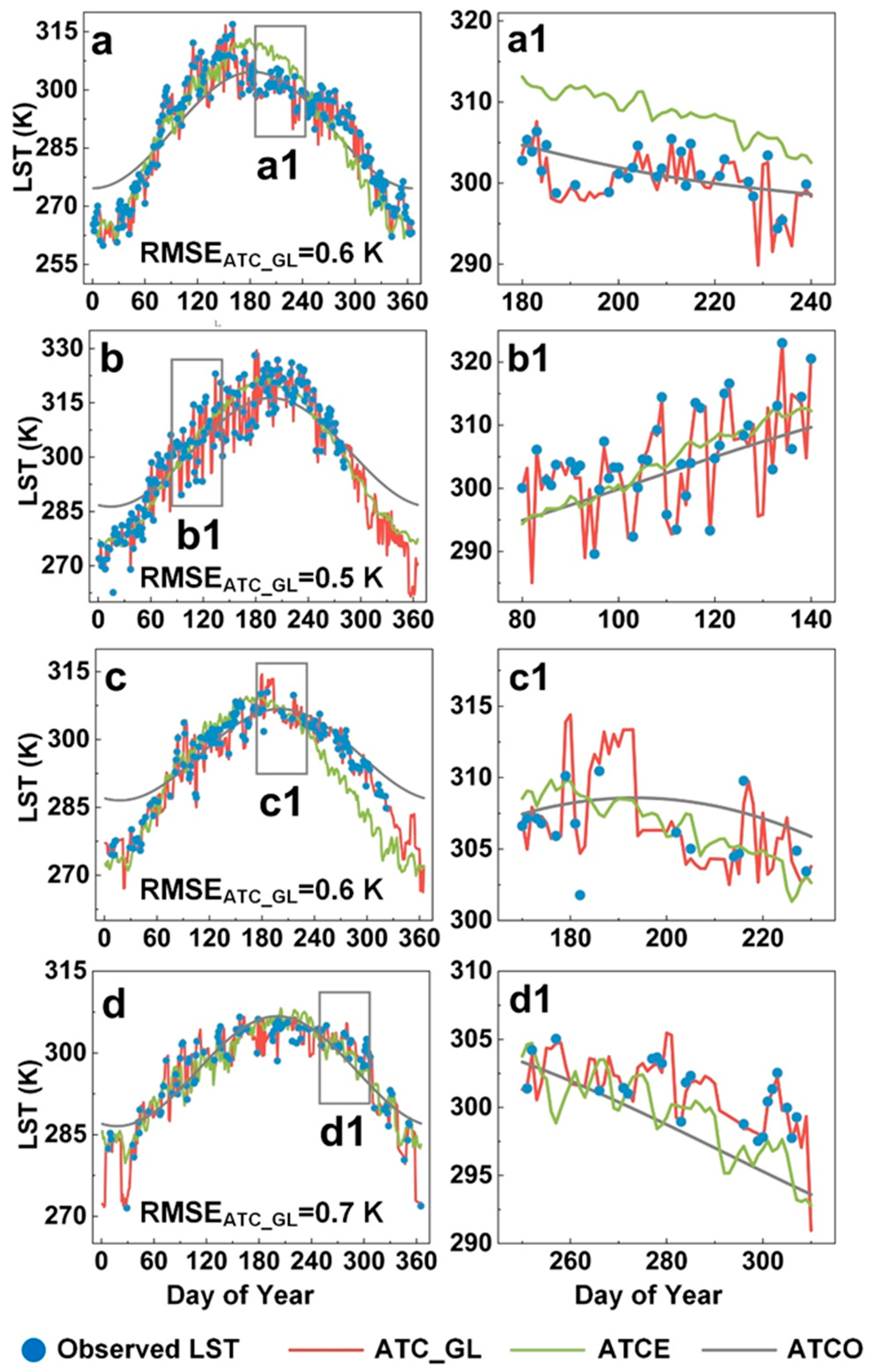
4.1. Comparison of Model Performances in Strategy 1
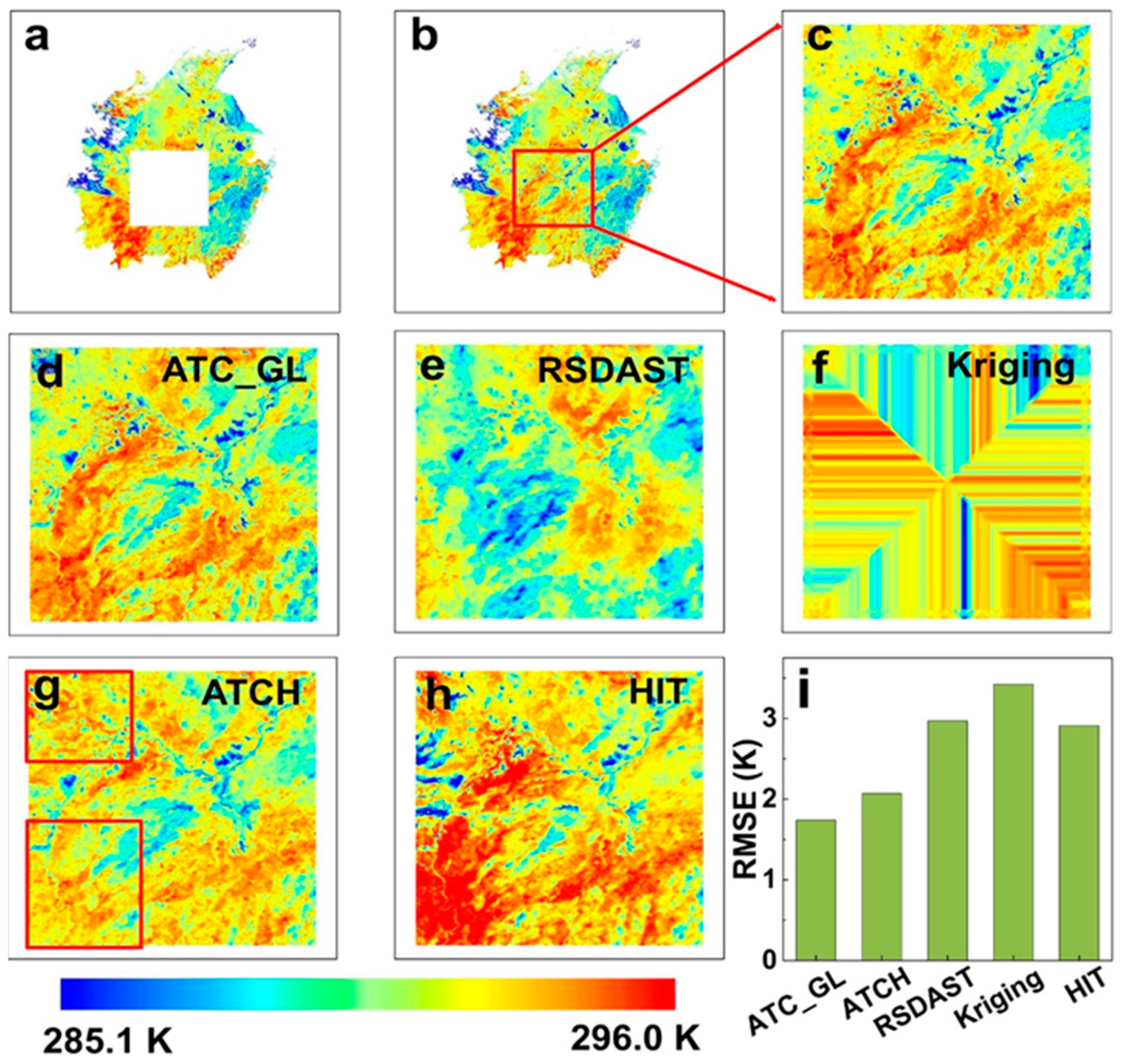
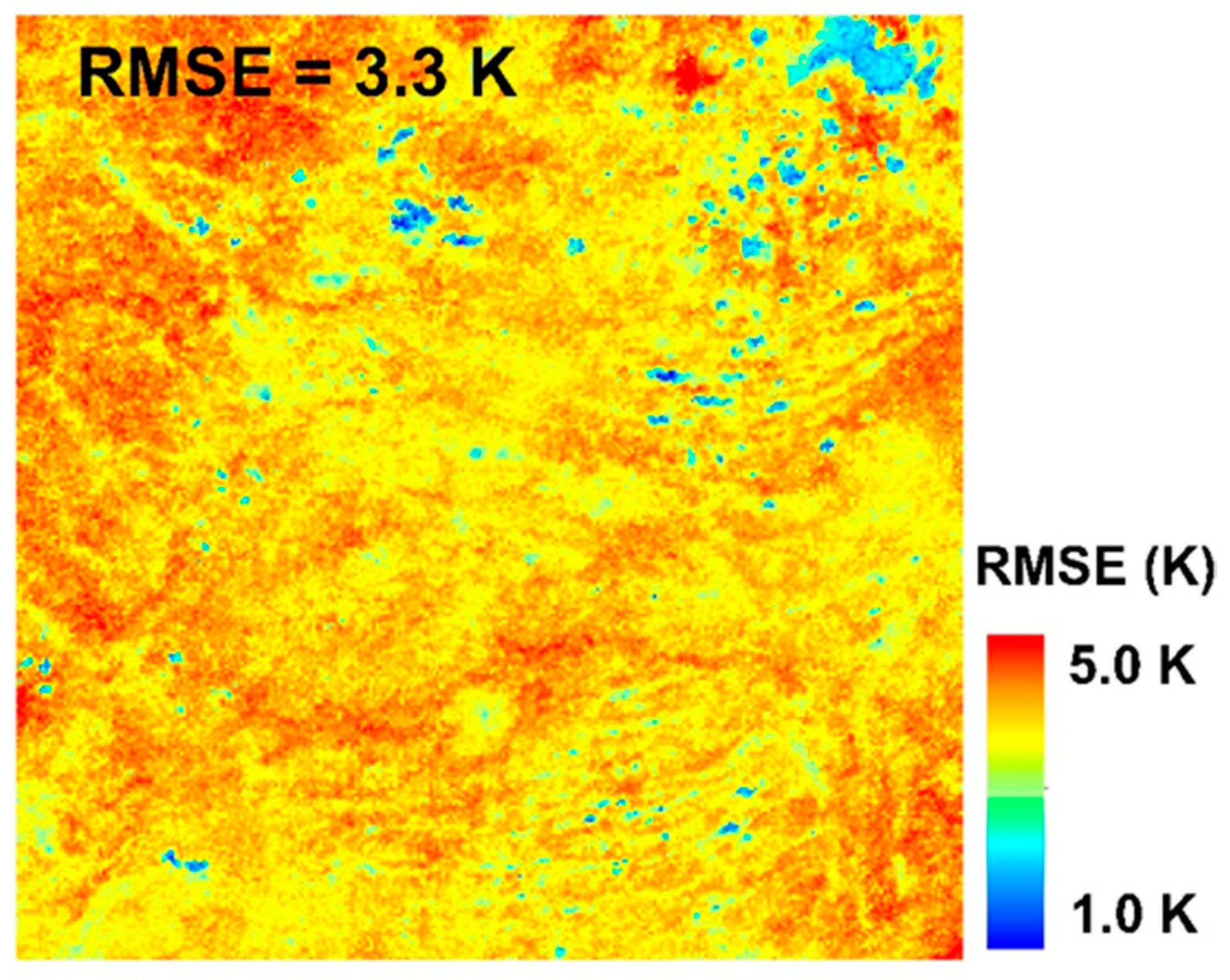
4.1.1. Spatial Distribution of Model Performances
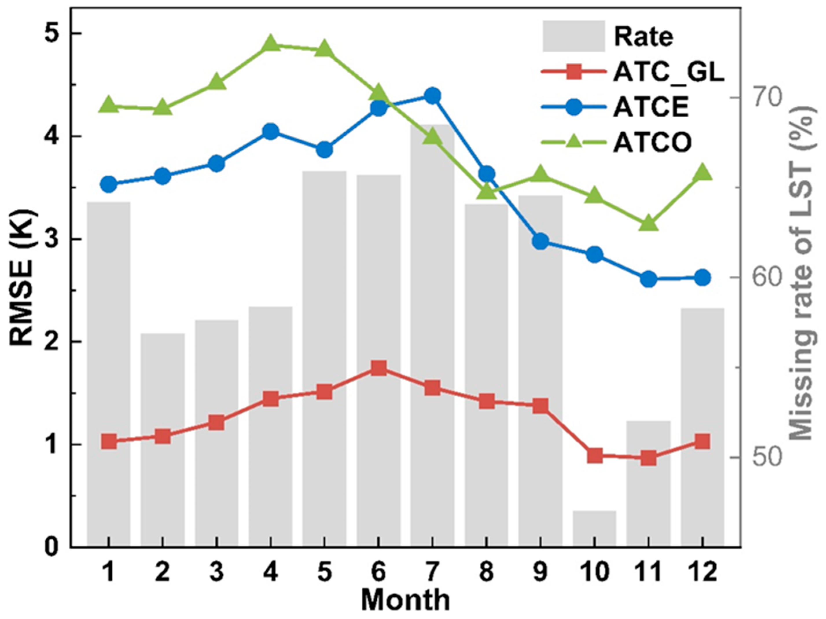
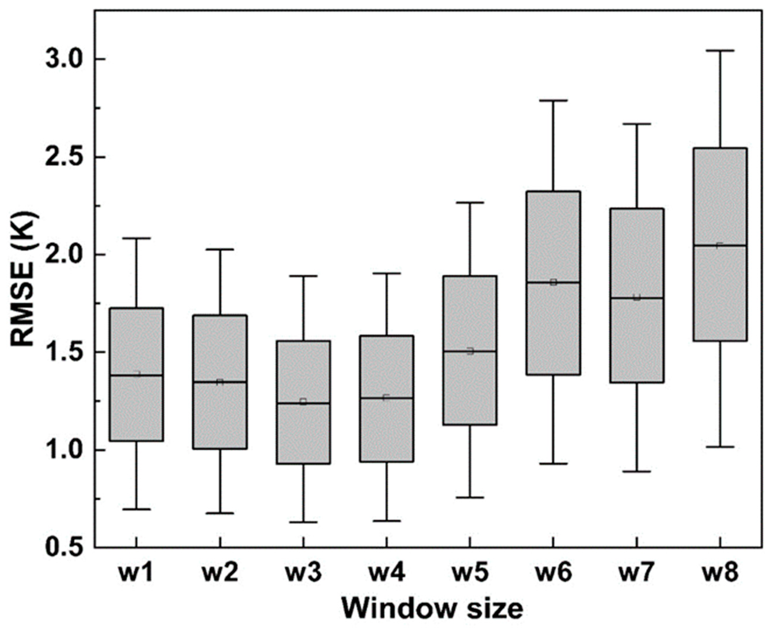
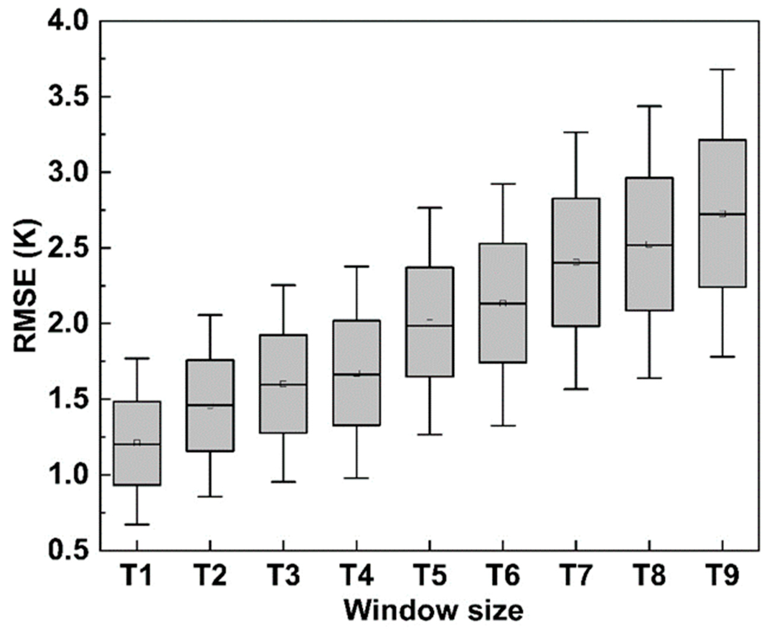
4.1.2. Monthly and Daily Performance of the Models
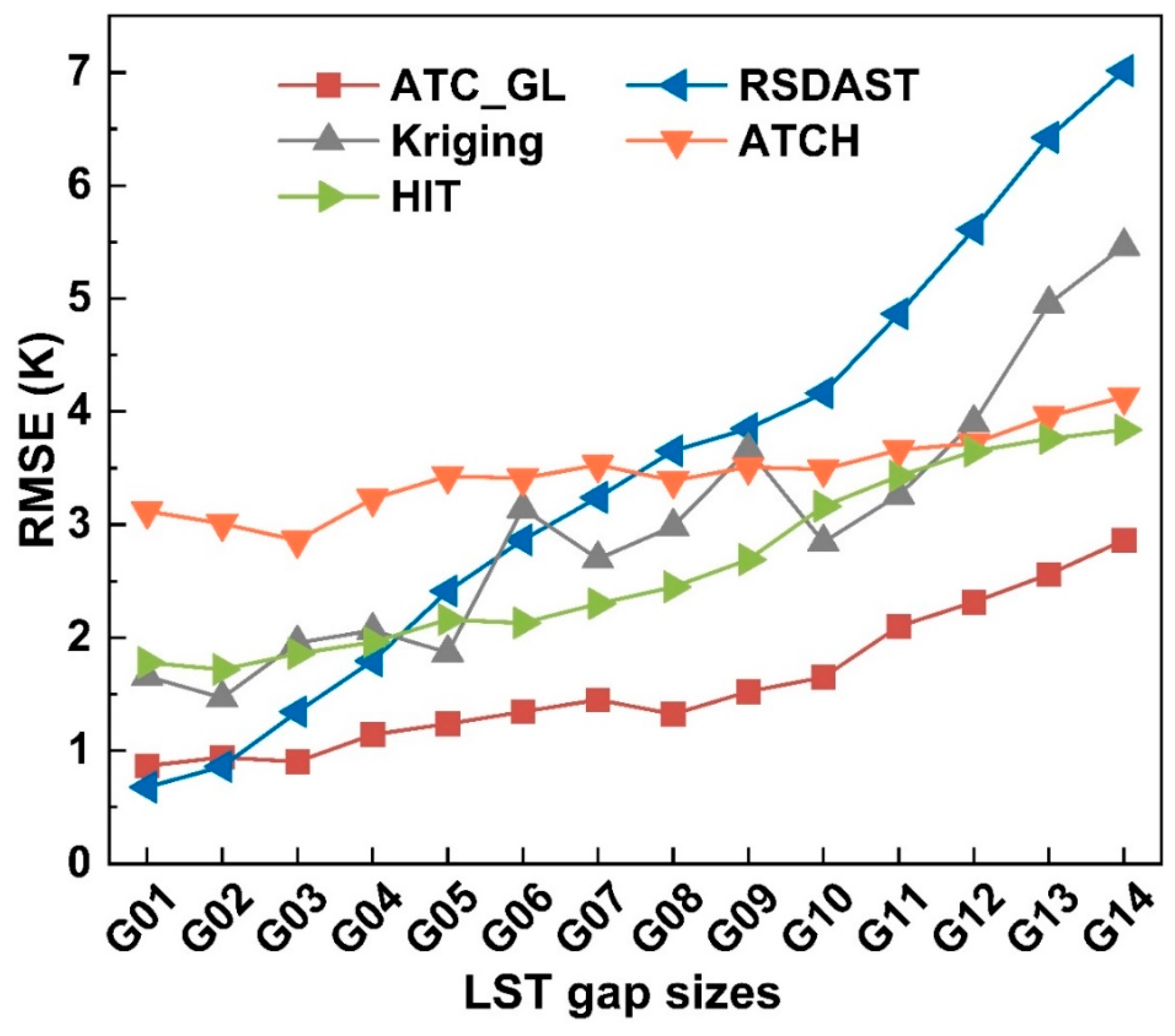
4.2. Comparison of Model Performances in Strategy 2
4.3. Comparison of Model Performances in Strategy 3
5. Discussion
5.1. Advantages of the ATC_GL Reference to Previous Methods
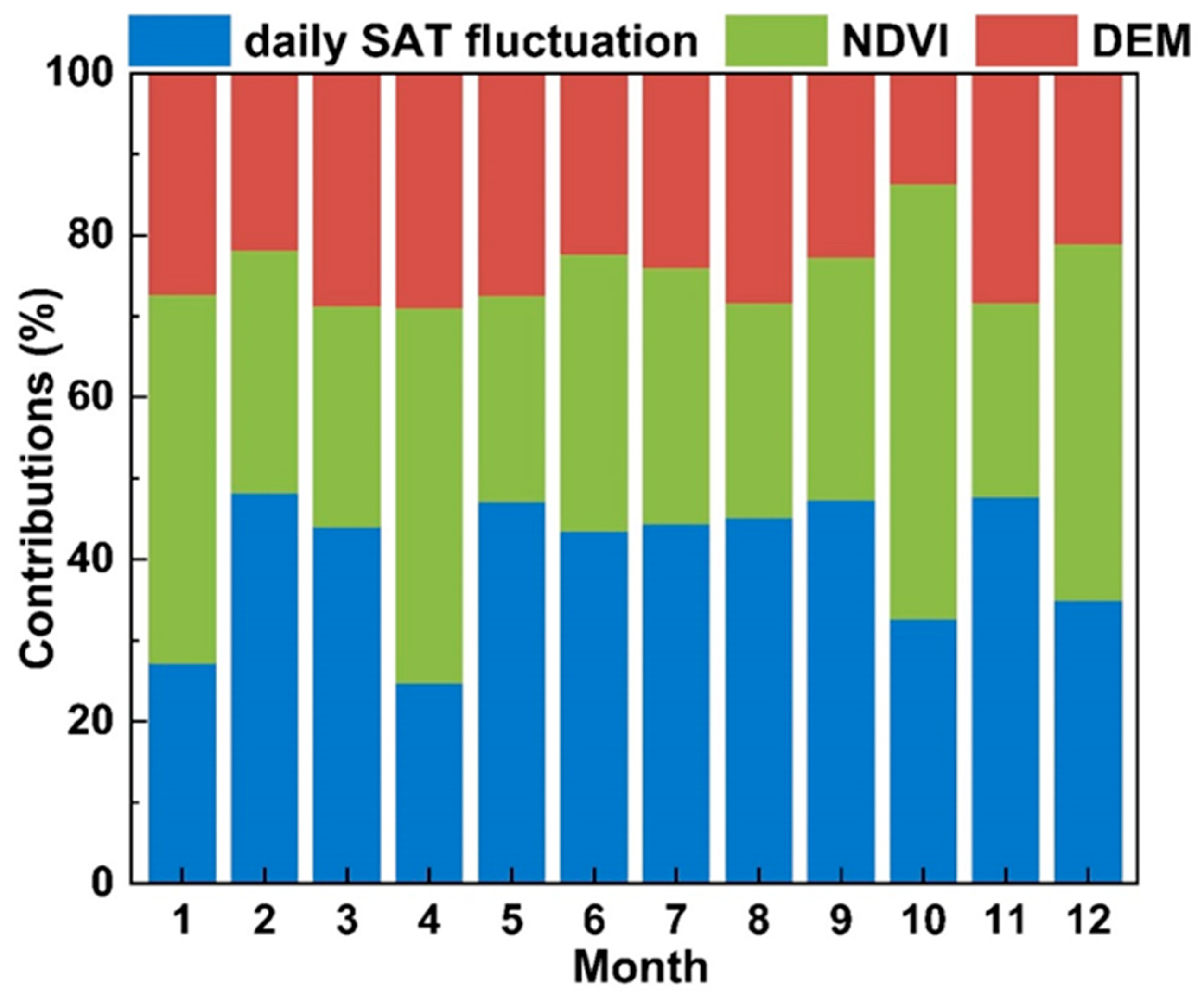
5.2. Contributions of LST-Related Descriptors in the Estimation of Daily LST Fluctuations
5.3. Limitations and Prospects
6. Conclusions
Author Contributions
Funding
Data Availability Statement
Acknowledgments
Conflicts of Interest
Appendix A


| Group | Increase in Spatial Window Size (km) | Increase in Temporal Window Size (Day) | RMSE (K) | R2 |
|---|---|---|---|---|
| A | 2 | 2 | 0.95 | 0.95 |
| B | 4 | 2 | 0.97 | 0.94 |
| C | 6 | 2 | 0.98 | 0.94 |
| D | 2 | 4 | 1.03 | 0.92 |
| E | 4 | 4 | 0.97 | 0.93 |
| F | 6 | 4 | 1.04 | 0.91 |
| G | 2 | 6 | 1.08 | 0.89 |
| H | 4 | 6 | 1.04 | 0.91 |
| I | 6 | 6 | 1.05 | 0.92 |
Appendix B

Appendix C

References
- Tomlinson, C.J.; Chapman, L.; Thornes, J.E.; Baker, C.J. Derivation of Birmingham’s summer surface urban heat island from MODIS satellite images. Int. J. Climatol. 2012, 32, 214–224. [Google Scholar] [CrossRef]
- Voogt, J.A.; Oke, T.R. Thermal remote sensing of urban climates. Remote Sens. Environ. 2003, 86, 370–384. [Google Scholar] [CrossRef]
- Holzman, M.E.; Rivas, R.; Piccolo, M.C. Estimating soil moisture and the relationship with crop yield using surface temperature and vegetation index. Int. J. Appl. Earth Obs. Geoinf. 2014, 28, 181–192. [Google Scholar] [CrossRef]
- Giglio, L.; Descloitres, J.; Justice, C.O.; Kaufman, Y.J. An enhanced contextual fire detection algorithm for MODIS. Remote Sens. Environ. 2003, 87, 273–282. [Google Scholar] [CrossRef]
- Guo, G.; Zhou, M. Using MODIS land surface temperature to evaluate forest fire risk of northeast China. IEEE Geosci. Remote Sens. Lett. 2004, 1, 98–100. [Google Scholar]
- Sun, L.; Chen, Z.; Gao, F.; Anderson, M.; Song, L.; Wang, L.; Hu, B.; Yang, Y. Reconstructing daily clear-sky land surface temperature for cloudy regions from MODIS data. Comput. Geosci. 2017, 105, 10–20. [Google Scholar] [CrossRef]
- Jin, M. Interpolation of surface radiative temperature measured from polar orbiting satellites to a diurnal cycle: 2. Cloudy-pixel treatment. J. Geophys. Res. Atmos. 2000, 105, 4061–4076. [Google Scholar] [CrossRef]
- Zeng, C.; Long, D.; Shen, H.; Wu, P.; Cui, Y.; Hong, Y. A two-step framework for reconstructing remotely sensed land surface temperatures contaminated by cloud. ISPRS-J. Photogramm. Remote Sens. 2018, 141, 30–45. [Google Scholar] [CrossRef]
- Crosson, W.L.; Al-Hamdan, M.Z.; Hemmings, S.N.J.; Wade, G.M. A daily merged MODIS Aqua–Terra land surface temperature data set for the conterminous United States. Remote Sens. Environ. 2012, 119, 315–324. [Google Scholar] [CrossRef]
- Duan, S.; Li, Z.; Leng, P. A framework for the retrieval of all-weather land surface temperature at a high spatial resolution from polar-orbiting thermal infrared and passive microwave data. Remote Sens. Environ. 2017, 195, 107–117. [Google Scholar] [CrossRef]
- Hengl, T.; Heuvelink, G.B.M.; Tadić, M.P.; Pebesma, E.J. Spatio-temporal prediction of daily temperatures using time-series of MODIS LST images. Theor. Appl. Climatol. 2012, 107, 265–277. [Google Scholar] [CrossRef]
- Ke, L.; Song, C.; Ding, X. Reconstructing complete MODIS LST based on temperature gradients in northeastern Qinghai-Tibet Plateau. In Proceedings of the 2012 IEEE International Geoscience and Remote Sensing Symposium, Munich, Germany, 22–27 July 2012; pp. 22–27. [Google Scholar]
- Zhang, X.; Zhou, J.; Göttsche, F.; Zhan, W.; Liu, S.; Cao, R. A method based on temporal component decomposition for estimating 1-km all-weather land surface temperature by merging satellite thermal infrared and passive microwave observations. IEEE Trans. Geosci. Remote Sens. 2019, 57, 4670–4691. [Google Scholar] [CrossRef]
- Zhang, X.; Zhou, J.; Liang, S.; Chai, L.; Wang, D.; Liu, J. Estimation of 1-km all-weather remotely sensed land surface temperature based on reconstructed spatial-seamless satellite passive microwave brightness temperature and thermal infrared data. ISPRS J. Photogramm. Remote Sens. 2020, 167, 321–344. [Google Scholar] [CrossRef]
- Zhang, X.; Zhou, J.; Liang, S.; Wang, D. A practical reanalysis data and thermal infrared remote sensing data merging (RTM) method for reconstruction of a 1-km all-weather land surface temperature. Remote Sens. Environ. 2021, 260, 112437. [Google Scholar] [CrossRef]
- Zhao, W.; Duan, S. Reconstruction of daytime land surface temperatures under cloud-covered conditions using integrated MODIS/Terra land products and MSG geostationary satellite data. Remote Sens. Environ. 2020, 247, 111931. [Google Scholar] [CrossRef]
- Bechtel, B.; Sismanidis, P. Time Series Analysis of Moderate Resolution Land Surface Temperatures. In Remote Sensing: Time Series Image Processing; Weng, Q., Ed.; Taylor & Francis: Abingdon, UK, 2017. [Google Scholar]
- Li, X.; Zhou, Y.; Asrar, G.R.; Zhu, Z. Creating a seamless 1 km resolution daily land surface temperature dataset for urban and surrounding areas in the conterminous United States. Remote Sens. Environ. 2018, 206, 84–97. [Google Scholar] [CrossRef]
- Liu, Z.; Zhan, W.; Lai, J.; Hong, F.; Quan, J.; Bechtel, B.; Huang, F.; Zou, Z. Balancing prediction accuracy and generalization ability: A hybrid framework for modelling the annual dynamics of satellite-derived land surface temperatures. ISPRS-J. Photogramm. Remote Sens. 2019, 151, 189–206. [Google Scholar] [CrossRef]
- Weng, Q.; Fu, P. Modeling annual parameters of clear-sky land surface temperature variations and evaluating the impact of cloud cover using time series of Landsat TIR data. Remote Sens. Environ. 2014, 140, 267–278. [Google Scholar] [CrossRef]
- Wu, P.; Yin, Z.; Yang, H.; Wu, Y.; Ma, X. Reconstructing geostationary satellite land surface temperature imagery based on a multiscale feature connected convolutional neural network. Remote Sens. 2019, 11, 300. [Google Scholar] [CrossRef]
- Zou, Z.; Zhan, W.; Liu, Z.; Bechtel, B.; Gao, L.; Hong, F.; Huang, F.; Lai, J. Enhanced modeling of annual temperature cycles with temporally discrete remotely sensed thermal observations. Remote Sens. 2018, 10, 650. [Google Scholar] [CrossRef]
- Xia, H.; Chen, Y.; Gong, A.; Li, K.; Liang, L.; Guo, Z. Modeling daily temperatures via a phenology-based annual temperature cycle model. IEEE J. Sel. Top. Appl. Earth Observ. Remote Sens. 2021, 14, 6219–6229. [Google Scholar] [CrossRef]
- Chen, F.; Liu, C. Estimation of the spatial rainfall distribution using inverse distance weighting (IDW) in the middle of Taiwan. Paddy Water Environ. 2012, 10, 209–222. [Google Scholar] [CrossRef]
- Liu, Z.; Wu, P.; Duan, S.; Zhan, W.; Ma, X.; Wu, Y. Spatiotemporal reconstruction of land surface temperature derived from FengYun geostationary satellite data. IEEE J. Sel. Top. Appl. Earth Observ. Remote Sens. 2017, 10, 4531–4543. [Google Scholar] [CrossRef]
- Zhou, Y.; Qin, Z.; Bao, G. Land surface temperature estimation under cloud cover with GIDS. J. Remote Sens. 2012, 16, 492–504. [Google Scholar]
- Tu, L.; Qin, Z.H.; Zhang, J.; Liu, M.; Geng, J. Estimation and error analysis of land surface temperature under the cloud based on spatial interpolation. Remote Sens. Inf. 2011, 59–63. [Google Scholar]
- Wu, P.; Yin, Z.; Zeng, C.; Duan, S.; Gottsche, F.M.; Ma, X.; Li, X.; Yang, H.; Shen, H. Spatially continuous and high-resolution land surface temperature product generation: A review of reconstruction and spatiotemporal fusion techniques. IEEE Geosci. Remote Sens. Mag. 2021, 9, 112–137. [Google Scholar]
- Lyon, S.W.; Sorensen, R.; Stendahl, J.; Seibert, J. Using landscape characteristics to define an adjusted distance metric for improving kriging interpolations. Int. J. Geogr. Inf. Sci. 2010, 24, 723–740. [Google Scholar] [CrossRef]
- Zhang, C.; Li, W.; Travis, D. Gaps-fill of SLC-off Landsat ETM+ satellite image using a geostatistical approach. Int. J. Remote Sens. 2007, 28, 5103–5122. [Google Scholar] [CrossRef]
- Bechtel, B. Multitemporal Landsat data for urban heat island assessment and classification of local climate zones. In Proceedings of the IEEE Joint Urban Remote Sensing Event (JURSE), Munich, Germany, 11–13 April 2011; pp. 129–132. [Google Scholar]
- Hong, F.; Zhan, W.; Göttsche, F.-M.; Liu, Z.; Zhou, J.; Huang, F.; Lai, J.; Li, M. Comprehensive assessment of four-parameter diurnal land surface temperature cycle models under clear-sky. ISPRS-J. Photogramm. Remote Sens. 2018, 142, 190–204. [Google Scholar] [CrossRef]
- Huang, F.; Zhan, W.; Duan, S.; Ju, W.; Quan, J. A generic framework for modeling diurnal land surface temperatures with remotely sensed thermal observations under clear sky. Remote Sens. Environ. 2014, 150, 140–151. [Google Scholar] [CrossRef]
- Fu, P.; Weng, Q. Consistent land surface temperature data generation from irregularly spaced Landsat imagery. Remote Sens. Environ. 2016, 184, 175–187. [Google Scholar] [CrossRef]
- Hong, F.; Zhan, W.; Göttsche, F.-M.; Lai, J.; Liu, Z.; Hu, L.; Fu, P.; Huang, F.; Li, J.; Li, H.; et al. A simple yet robust framework to estimate accurate daily mean land surface temperature from thermal observations of tandem polar orbiters. Remote Sens. Environ. 2021, 264, 112612. [Google Scholar] [CrossRef]
- Zhan, W.; Huang, F.; Quan, J.; Zhu, X.; Gao, L.; Zhou, J.; Ju, W. Disaggregation of remotely sensed land surface temperature: A new dynamic methodology. J. Geophys. Res. Atmos. 2016, 121, 10,538–10,554. [Google Scholar] [CrossRef]
- Huang, F.; Zhan, W.; Voogt, J.; Hu, L.; Wang, Z.; Quan, J.; Ju, W.; Guo, Z. Temporal upscaling of surface urban heat island by incorporating an annual temperature cycle model: A tale of two cities. Remote Sens. Environ. 2016, 186, 1–12. [Google Scholar] [CrossRef]
- Xu, Y.; Shen, Y. Reconstruction of the land surface temperature time series using harmonic analysis. Comput. Geosci. 2013, 61, 126–132. [Google Scholar] [CrossRef]
- Scharlemann, J.P.; Benz, D.; Hay, S.I.; Purse, B.V.; Tatem, A.J.; Wint, G.R.; Rogers, D.J. Global data for ecology and epidemiology: A novel algorithm for temporal Fourier processing MODIS data. PLoS ONE 2008, 3, e1408. [Google Scholar] [CrossRef]
- Bechtel, B. Robustness of annual cycle parameters to characterize the urban thermal landscapes. IEEE Geosci. Remote Sens. Lett. 2012, 9, 876–880. [Google Scholar] [CrossRef]
- Li, B.; Liang, S.; Liu, X.; Ma, H.; Chen, Y.; Liang, T.; He, T. Estimation of all-sky 1 km land surface temperature over the conterminous United States. Remote Sens. Environ. 2021, 266, 112707. [Google Scholar] [CrossRef]
- Fu, H.; Shao, Z.; Fu, P.; Huang, X.; Cheng, T.; Fan, Y. Combining ATC and 3D-CNN for reconstructing spatially and temporally continuous land surface temperature. Int. J. Appl. Earth Obs. Geoinf. 2022, 108, 102733. [Google Scholar] [CrossRef]
- Wang, W.; Zeng, Z.; Karl, T.R. Urban heat islands in China. Geophys. Res. Lett. 1990, 17, 2377–2380. [Google Scholar] [CrossRef]
- Wan, Z.; Zhang, Y.; Zhang, Q.; Li, Z. Validation of the land-surface temperature products retrieved from Terra Moderate Resolution Imaging Spectroradiometer data. Remote Sens. Environ. 2002, 83, 163–180. [Google Scholar] [CrossRef]
- Wan, Z. New refinements and validation of the collection-6 MODIS land-surface temperature/emissivity product. Remote Sens. Environ. 2014, 140, 36–45. [Google Scholar] [CrossRef]
- Liu, Y.; Xiao, J.; Ju, W.; Zhou, Y.; Wang, S.; Wu, X. Water use efficiency of China’s terrestrial ecosystems and responses to drought. Sci. Rep. 2015, 5, 13799. [Google Scholar] [CrossRef] [PubMed]
- Ermida, S.L.; Soares, P.; Mantas, V.; Gottsche, F.-M.; Trigo, I.F. Google earth engine open-source code for land surface temperature estimation from the Landsat series. Remote Sens. 2020, 12, 1471. [Google Scholar] [CrossRef]
- Yu, W.; Ma, M.; Yang, H.; Tan, J.; Li, X. Supplement of the radiance-based method to validate satellite-derived land surface temperature products over heterogeneous land surfaces. Remote Sens. Environ. 2019, 230, 111188. [Google Scholar] [CrossRef]
- Breiman, L. Bagging Predictors. Mach. Learn. 1996, 24, 123–140. [Google Scholar] [CrossRef]
- Hutengs, C.; Vohland, M. Downscaling land surface temperatures at regional scales with random forest regression. Remote Sens. Environ. 2016, 178, 127–141. [Google Scholar] [CrossRef]
- Tan, W.; Wei, C.; Lu, Y.; Xue, D. Reconstruction of All-Weather Daytime and Nighttime MODIS Aqua-Terra Land Surface Temperature Products Using an XGBoost Approach. Remote Sens. 2021, 13, 4723. [Google Scholar] [CrossRef]
- Sun, D.; Kafatos, M. Note on the NDVI-LST relationship and the use of temperature-related drought indices over North America. Geophys. Res. Lett. 2007, 34. [Google Scholar] [CrossRef]
- Van De Kerchove, R.; Lhermitte, S.; Veraverbeke, S.; Goossens, R. Spatio-temporal variability in remotely sensed land surface temperature, and its relationship with physiographic variables in the Russian Altay Mountains. Int. J. Appl. Earth Obs. Geoinf. 2013, 20, 4–19. [Google Scholar] [CrossRef]
- Weng, Q. Thermal infrared remote sensing for urban climate and environmental studies: Methods, applications, and trends. ISPRS-J. Photogramm. Remote Sens. 2009, 64, 335–344. [Google Scholar] [CrossRef]
- Weng, Q.; Lu, D.; Schubring, J. Estimation of land surface temperature–vegetation abundance relationship for urban heat island studies. Remote Sens. Environ. 2004, 89, 467–483. [Google Scholar] [CrossRef]
- Yu, W.; Nan, Z.; Wang, Z.; Chen, H.; Wu, T.; Zhao, L. An effective interpolation method for MODIS land surface temperature on the Qinghai-Tibet plateau. IEEE J. Sel. Top. Appl. Earth Obs. Remote Sens. 2015, 8, 4539–4550. [Google Scholar] [CrossRef]
- Lin, X.; Zhang, W.; Huang, Y.; Sun, W.; Han, P.; Yu, L. Empirical estimation of near-surface air temperature in china from MODIS LST data by considering physiographic features. Remote Sens. 2016, 8, 629. [Google Scholar] [CrossRef]
- Mildrexler, D.J.; Zhao, M.; Running, S.W. A global comparison between station air temperatures and MODIS land surface temperatures reveals the cooling role of forests. J. Geophys. Res. 2011, 116, G03025. [Google Scholar] [CrossRef]
- Good, E.J. An in situ-based analysis of the relationship between land surface “skin” and screen-level air temperatures. J. Geophys. Res. Atmos. 2016, 121, 8801–8819. [Google Scholar] [CrossRef]
- Hu, L.; Sun, Y.; Collins, G.; Fu, P. Improved estimates of monthly land surface temperature from MODIS using a diurnal temperature cycle (DTC) model. ISPRS J. Photogramm. Remote Sens. 2020, 168, 131–140. [Google Scholar] [CrossRef]
- Wang, K.; Zhou, C. Regional contrasts of the warming rate over land significantly depend on the calculation methods of mean air temperature. Sci. Rep. 2015, 5, 12324. [Google Scholar] [CrossRef]
- Murray, K.; Conner, M. Methods to quantify variable importance implications for the analysis of noisy ecological data. Ecology 2009, 90, 348–355. [Google Scholar] [CrossRef]
- Good, E.J.; Ghent, D.J.; Bulgin, C.E.; Remedios, J.J. A spatiotemporal analysis of the relationship between near-surface air temperature and satellite land surface temperatures using 17 years of data from the ATSR series. J. Geophys. Res. Atmos. 2017, 122, 9185–9210. [Google Scholar] [CrossRef]
- Sohrabinia, M.; Zawar-Reza, P.; Rack, W. Spatio-temporal analysis of the relationship between LST from MODIS and air temperature in New Zealand. Theor. Appl. Climatol. 2014, 119, 567–583. [Google Scholar] [CrossRef]
- Duan, S.; Li, Z.; Tang, B.; Wu, H.; Tang, R. Generation of a time-consistent land surface temperature product from MODIS data. Remote Sens. Environ. 2014, 140, 339–349. [Google Scholar] [CrossRef]
- Hu, L.; Brunsell, N.A.; Monaghan, A.J.; Barlage, M.; Wilhelmi, O.V. How can we use MODIS land surface temperature to validate long-term urban model simulations? J. Geophys. Res. Atmos. 2014, 119, 3185–3201. [Google Scholar] [CrossRef]
- Hu, L.; Monaghan, A.; Voogt, J.A.; Barlage, M. A first satellite-based observational assessment of urban thermal anisotropy. Remote Sens. Environ. 2016, 181, 111–121. [Google Scholar] [CrossRef]
- Jin, M.; Mullens, T. A Study of the relations between soil moisture, soil temperatures and surface temperatures using ARM observations and offline CLM4 simulations. Climate 2014, 2, 279–295. [Google Scholar] [CrossRef]
- Ke, L.; Ding, X.; Song, C. Reconstruction of time-series MODIS LST in central Qinghai-Tibet Plateau using geostatistical approach. IEEE Geosci. Remote Sens. Lett. 2013, 10, 1602–1606. [Google Scholar] [CrossRef]
- Zhu, X.; Duan, S.; Li, Z.; Wu, P.; Wu, H.; Zhao, W.; Qian, Y. Reconstruction of land surface temperature under cloudy conditions from Landsat 8 data using annual temperature cycle model. Remote Sens. Environ. 2022, 281, 113261. [Google Scholar] [CrossRef]
- Zeng, C.; Shen, H.; Zhong, M.; Zhang, L.; Wu, P. Reconstructing MODIS lst based on multitemporal classification and robust regression. IEEE Geosci. Remote Sens. Lett. 2015, 12, 512–516. [Google Scholar] [CrossRef]
- Gerber, F.; Furrer, R.; Schaepman-Strub, G.; de Jong, R.; Schaepman, M.E. Predicting missing values in spatio-temporal satellite data. arXiv 2016, arXiv:1605.01038. [Google Scholar]
- Li, K.; Chen, Y.; Xia, H.; Gong, A.; Guo, Z. Adjustment from Temperature Annual Dynamics for Reconstructing Land Surface Temperature Based on Downscaled Microwave Observations. IEEE J. Sel. Top. Appl. Earth Observ. Remote Sens. 2020, 13, 5272–5283. [Google Scholar] [CrossRef]
- Pan, X.; Liu, Y.; Fan, X.; Gan, G.; Yang, Y.; Chen, Y. Quantifying the contributions of environmental parameters to satellite-retrieved surface net longwave radiation error: An examination on ceres dataset in China. In Proceedings of the IEEE International Geoscience and Remote Sensing Symposium (IGARSS), Fort Worth, TX, USA, 23–28 July 2017; pp. 5732–5735. [Google Scholar]
- Wang, B.; Bao, Q.; Hoskins, B.; Wu, G.X.; Liu, Y.M. Tibetan plateau warming and precipitation changes in East Asia. Geophys. Res. Lett. 2008, 35, L14702. [Google Scholar] [CrossRef]


| Study Area | Geographical Zone | Location | Area (km2) | LST Missing Rate * |
|---|---|---|---|---|
| A | Northeast | 122.5° E, 44.3° N | 300 × 300 | 44.47% |
| B | Northwest | 92.4° E, 38.8° N | 300 × 300 | 37.51% |
| C | North | 114.1° E, 38.6° N | 300 × 300 | 53.00% |
| D | Central | 112.5° E, 30.9° N | 300 × 300 | 69.98% |
| E | Southwest | 101.4° E, 29.4° N | 300 × 300 | 61.01% |
| F | East | 118.0° E, 28.5° N | 300 × 300 | 71.36% |
| G | South | 109.8° E, 23.7° N | 300 × 300 | 85.07% |
| H | East-central | 114.5° E, 29.3° N | 600 × 600 | 71.55% |
| Data Type | Variable | Product Name | Year | Temporal/Spatial Resolution |
|---|---|---|---|---|
| Satellite data | Land Surface Temperature | MOD11A1 | 2018 | Daily/1 km |
| MYD11A1 | 2014 | Daily/1 km | ||
| Normalized Difference Vegetation Index | MOD13A2 | 2018/ 2014 | 16 day/1 km | |
| Land cover type | MCD12Q1 | 2018 | Yearly/0.5 km | |
| In situ measurements | Surface Air Temperature | — | 2018/ 2014 | Daily/— |
| Land Surface Temperature | SURFRAD | 2018 | Daily/— | |
| Auxiliary data | Digital Elevation Model | SRTM3 | 2018/ 2014 | Yearly/0.09 km |
| All-weather LST | LSTMW | 2014 | Daily/1 km |
| Abbreviations | Descriptions |
|---|---|
| Ts | The modeled LST on day d relative to the spring equinox |
| Tg | The general seasonal cycle of the intra-annual LST dynamics |
| ΔTs | The daily LST fluctuations |
| gATCT | The Tg modeled by the ATCT |
| fRF | The daily LST fluctuations modeled using the RF algorithm |
| X | The synoptic and surface parameters |
| The annual mean LST | |
| A1, A2 | The two amplitudes of the ATCT |
| ω1, ω2 | The two constants calculated as 2πN−1 and 4πN−1 (N = 365) |
| θ1, θ2 | The corresponding phase shifts relative to the spring equinox |
| gATCT_a | The seasonal cycle in the intra-annual SAT dynamics determined by the ATCT |
| A3, A4 | The two ATCT amplitudes of SAT |
| RMSE (K) | R2 | |||||
|---|---|---|---|---|---|---|
| ATC_GL | ATCE | ATCO | ATC_GL | ATCE | ATCO | |
| Forest | 1.2 | 3.4 | 3.7 | 0.95 | 0.90 | 0.89 |
| Cropland | 0.9 | 3.5 | 4.1 | 0.96 | 0.89 | 0.87 |
| Grassland | 1.1 | 3.6 | 4.1 | 0.95 | 0.88 | 0.87 |
| Wetland | 1.1 | 3.0 | 3.6 | 0.95 | 0.92 | 0.91 |
| Barren | 1.8 | 5.3 | 5.9 | 0.94 | 0.86 | 0.84 |
| Built up | 1.0 | 3.3 | 3.6 | 0.96 | 0.89 | 0.89 |
| Water | 1.1 | 2.8 | 3.3 | 0.95 | 0.89 | 0.89 |
| Site | RMSE (Unit: K) | Land Cover Type | ||
|---|---|---|---|---|
| Clear-Sky | Overcast | All-Weather | ||
| BON | 1.0 | 2.1 | 1.6 | Cropland |
| BOC | 0.6 | 3.1 | 1.6 | Grassland |
| DRA | 0.5 | 2.7 | 1.8 | Desert |
| FPK | 0.7 | 3.7 | 2.4 | Grassland |
| GWN | 0.6 | 3.8 | 2.7 | Grassland |
| PST | 0.5 | 4.1 | 3.3 | Cropland |
| SXF | 0.6 | 3.8 | 2.6 | Grassland |
Disclaimer/Publisher’s Note: The statements, opinions and data contained in all publications are solely those of the individual author(s) and contributor(s) and not of MDPI and/or the editor(s). MDPI and/or the editor(s) disclaim responsibility for any injury to people or property resulting from any ideas, methods, instructions or products referred to in the content. |
© 2023 by the authors. Licensee MDPI, Basel, Switzerland. This article is an open access article distributed under the terms and conditions of the Creative Commons Attribution (CC BY) license (https://creativecommons.org/licenses/by/4.0/).
Share and Cite
Chen, Y.; Zhan, W.; Liu, Z.; Dong, P.; Fu, H.; Miao, S.; Ji, Y.; Jiang, L.; Jiang, S. Combining Spatiotemporally Global and Local Interpolations Improves Modeling of Annual Land Surface Temperature Cycles. Land 2023, 12, 309. https://doi.org/10.3390/land12020309
Chen Y, Zhan W, Liu Z, Dong P, Fu H, Miao S, Ji Y, Jiang L, Jiang S. Combining Spatiotemporally Global and Local Interpolations Improves Modeling of Annual Land Surface Temperature Cycles. Land. 2023; 12(2):309. https://doi.org/10.3390/land12020309
Chicago/Turabian StyleChen, Yangyi, Wenfeng Zhan, Zihan Liu, Pan Dong, Huyan Fu, Shiqi Miao, Yingying Ji, Lu Jiang, and Sida Jiang. 2023. "Combining Spatiotemporally Global and Local Interpolations Improves Modeling of Annual Land Surface Temperature Cycles" Land 12, no. 2: 309. https://doi.org/10.3390/land12020309
APA StyleChen, Y., Zhan, W., Liu, Z., Dong, P., Fu, H., Miao, S., Ji, Y., Jiang, L., & Jiang, S. (2023). Combining Spatiotemporally Global and Local Interpolations Improves Modeling of Annual Land Surface Temperature Cycles. Land, 12(2), 309. https://doi.org/10.3390/land12020309