1. Introduction
“Neighborhood unity” is a concept that drives the utilization of 15-minute city models, going back to a 1923 Chicago architectural competition for building sustainable residential community blocks. This proposal countered the anonymity of large metropolitan city areas by introducing a characteristic cultural and vibrant local district where services and public facilities are within quick reach from civilian households [
1]. In a 15-minute city, as suggested by Carlos Moreno, residents of a particular urban region must be able to commute by walking or biking to cover their basic needs in 15 minutes or less. Moreno states that, under these circumstances, the six basic functionalities of decent urban living—living, working, commerce, health care, education, and entertainment—can be achieved. Subsequently, this specific model can substantially improve the quality of life of the residents. Accessibility and proximity are of prime importance, especially through cycling or walking, with a large socio-economic and environmentally positive impact [
2]. Micromobility is closely related to this urban planning model. Therefore, taking 15 minutes to walk or cycle to work, for leisure, and for personal care services is crucial in order to converge to the model described above. More specifically, educational institutions, healthcare centers, grocery stores, cultural centers, public services, cultural activities, and workspaces should be close for all residents and all neighborhoods.
The variety of urban environments worldwide can lead to a focus on several factors in the 15-minute city model as a framework for further development: in particular, easy accessibility, optimization of service proximity, socio-economically equal accessibility, a reduction in private driving, broader implementation of pedestrianization, etc. [
3]. The concept of 15-minute cities will make places more livable for and attractive to residents and their local economy. Neighborhood economies and local governments will have to adapt to more walking, bikes, and scooters to smooth the transition for 15-minute cities to become a reality. Micromobility and public transport will play a major role in this transition. The above urban planning model is committed to micromobility to achieve more humane and social productive metropolitan living [
4]. A fine paradigm of this new urbanism can be noticed in cities like Paris or Barcelona, where “Superblocks” in the latter restrict traffic to main driving arteries in favor of micromobility and pedestrians [
5].
The role of micromobility in 15-minute cities can be that of the first and last mile route connection (internationally, the term ‘first and last mile mobility’ describes the major routes of the first and last legs among several mobility options) in combination with public transport, independently via micromobility vehicles (e.g., e-scooters) as part of an exclusive route, or paired with walking [
6,
7]. The integration of these new modes of transportation in public transport systems may shift the modal share of private car usage in favor of micromobility, leading to more sustainable environments [
8,
9]. In addition, first- and last-kilometer services, through the use of micromobility options, have the potential to decrease emission levels and to improve air quality [
10,
11]. However, traditional public transport modes will remain key players for long-distance trips for urban mobility in cities, with micromobility options not likely to take the load from such routes [
12].
Urban and transport planners nowadays have to deal with the rapid spread of micromobility, mainly consisting of e-scooters and other electric devices, which bring in a substantial number of vehicles of different sizes and technological levels in contrast with traditional transportation modes, circulating within the limits of urban areas. Discussions are being carried out among European countries that suggest equating bicycles with e-scooters to set rules for these novel transportation modes. In order to accommodate this form of mobility, technicians and administrators argue about re-designing the urban surroundings to include all aspects of new and old transportation systems in co-existence. However, it is of prime necessity to emphasize some peculiar aspects of this transportation mode, namely safety, public transport integration, and access to main points of interest [
13].
It is critical to comprehend the key factors that influence the integration of micromobility as new mobility tech and services roll out over time. To achieve the target of smooth implementation, it is recommended to investigate the factors affecting preferences when adopting these new technologies and services in order to strategically implement policies and regulate urban transportation [
14].
Furthermore, greenways and urban trail paths have gained ground recently and are included in modern urban planning practices. Greenways are described as linear multifunctional landscapes that provide a range of socio-ecological benefits. As a domain of landscape planning research, greenways gradually gained traction from the late 20th century until today, when substantial interest in greenway planning and design has been noticed [
15]. For sustainable development, the design of trail paths must always consider both green environment services and land usage planning as inseparable parts in such projects [
16]. Some definitions of greenways can be found in Akpinar [
17], “Urban greenways which are often designed with multi-use trails that provide opportunities for physical activity, recreation and transportation are defined as places for nature in the city where people can fulfill recreational needs and achieve solitude and retreat without leaving the public realm”, and in Ngo et al. [
18], “Urban greenways are landscaped and traffic-calmed pathways with a mix of bicycle facilities and other streetscape improvements that link open spaces, parks, public facilities, and neighborhood centers together. Greenways support a variety of active travel uses, including walking, running, bicycling, and skating”. The Indianapolis Department of Parks and Recreation states for greenways: “Multi-use trails intended to connect various neighborhoods of the city and offer increased alternative pedestrian transportation choices” [
19].
The authors suggest that, in case appropriate conditions are secured, urban planning models such as the “15-minute city” could incorporate urban trail paths in their planning. These paths serve as a means of connectivity to access amenities not covered by the narrow proximity concept of a “neighborhood” but rather as a way of connecting residents to other 15-minute city neighborhoods. These urban pathways will provide safe, pleasant, and convenient routes located in beautiful landscapes with scenic views, offering access to various experiences related to health, alternative transportation, recreation, and local tourism. Simultaneously, they will connect neighborhoods without relying on car use, providing multiple benefits for users, society, and the environment. Micromobility constitutes a new way of traveling for short trips with proven results. This paper investigates the possibility of introducing micromobility as a means of connecting 15-minute city neighborhoods through urban trail paths.
2. Materials and Methods
This paper investigates the possibility of introducing micromobility as a means of connecting 15-minute cities and neighborhoods through urban trail paths. The analytical approach employed in this study is grounded in a comprehensive literature review. Insights presented in this article draw upon book chapters, numerous publications (including peer-reviewed papers), online webpages, and grey literature. Web of Science, Science Direct, and Google Scholar served as the primary databases for academic documents. The keywords used for the research encompassed “micromobility”, “15-minute city”, “urban trails”, “trail paths”, “greenways”, “urban planning”, “urban planning models”, and “case studies on urban trail paths”. The collected documents address sustainability advantages, underlying principles, and assessments related to micromobility, 15-minute cities, and urban trail paths. In conducting qualitative content analysis, the authors applied the inductive method. This approach combines data collection/extraction and analysis, progressively constructing the discussion. The total number of sources selected for the present research was 95.
The study’s structure is outlined as follows. The first section provides an introduction to the main issues, offering a comprehensive overview of the article’s central theme. This encompasses the integration of micromobility, 15-minute neighborhoods, and urban trail paths. The current section elucidates how the article is organized and outlines the reader’s expectations for subsequent sections. In section three, the principal concept of 15-minute cities is analyzed, along with the crucial role of micromobility as a key success factor in such a model. Section four delves into the analysis of micromobility and the factors influencing the adoption of such vehicles by users. Section five introduces urban trail paths, whether incorporated into the concept of urban greenways or not, as a contemporary urban planning idea fostering the shift towards less car-centric communities. The definitions and analysis of parameters influencing the use of urban trails by users, along with a brief reference to well-known related case studies, set the stage for further discussions and conclusions in sections six and seven, respectively.
3. The 15-Minute City
3.1. Historical Evolution of Neighborhood Planning
Many neighborhood planning concepts and approaches have been presented throughout the years in an effort to modify urban environments in order to improve their resilience and livability, as well as to promote sustainability and its social and economic elements [
2,
20,
21].
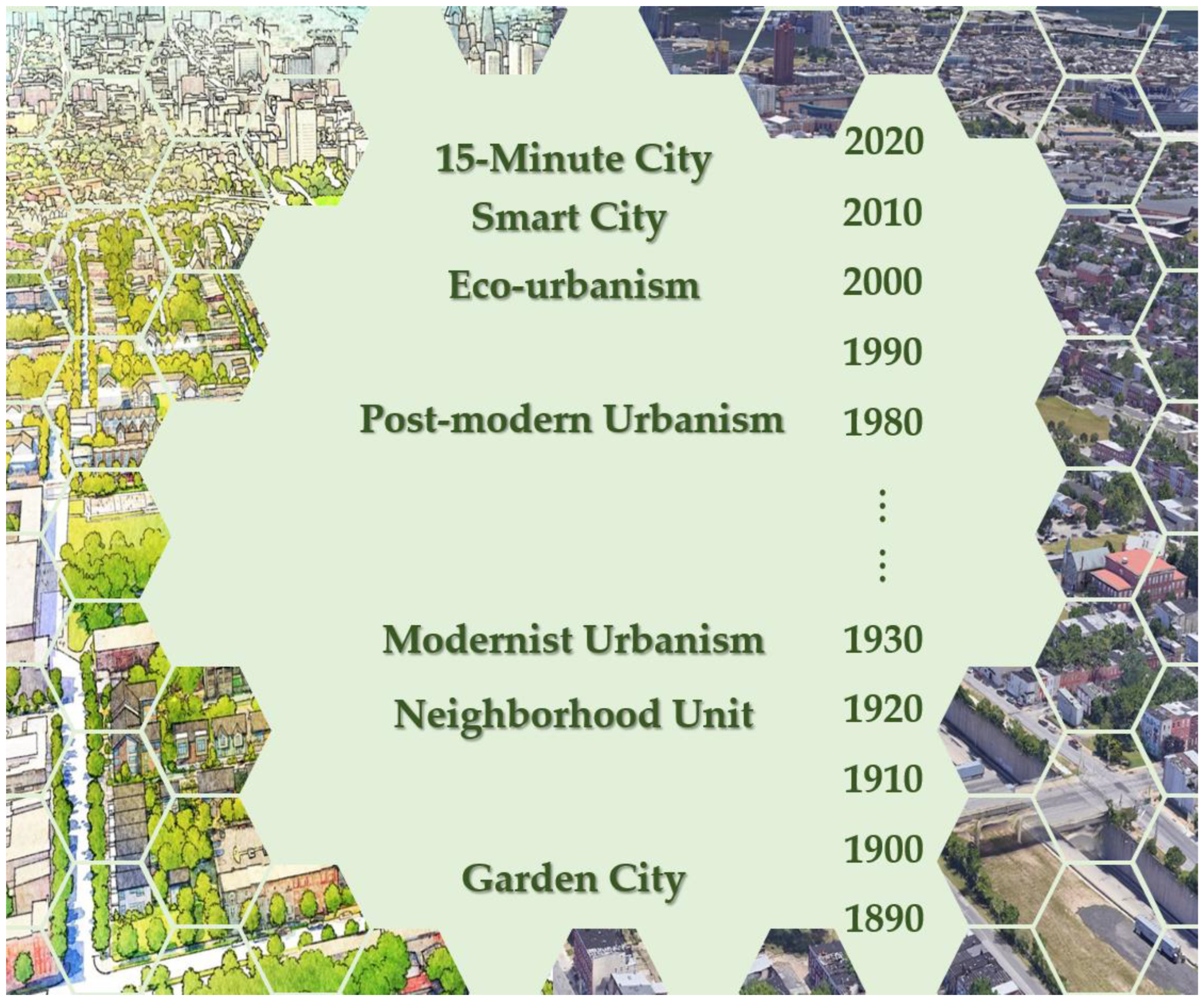
Figure 1 depicts the chronological evolution of various neighborhood planning concepts and approaches from the late 19th century onwards, which have been exceptionally and thoroughly analyzed by Rohe [
20] and Khavarian-Garmsir et al. [
21].
3.1.1. Pre-World-War-II Period
During the epoch of the industrial revolution, urban planners endeavored to optimize urban functionality by consolidating urban services, activities and amenities within city centers. The resultant centralized urban configuration gave rise to a plethora of challenges, including physical malformations and environmental degradation [
22]. The garden city concept, proposed by Ebenezer Howard in 1898 [
23], denoted a seminal urban planning concept that sought to address the social, environmental, and health challenges associated with traditional centralized urban configurations. Important to the garden city concept was the idea of creating self-contained and interconnected communities, blending the advantages of both rural and urban living. In Howard’s vision, a central city is enveloped by a greenbelt, acting as a buffer to prevent urban sprawl and preserve natural landscapes. This greenbelt not only enhances aesthetic appeal but also functions as both a recreational space and a physical barrier against uncontrolled urban expansion. The central city is accompanied by satellite towns, each planned to accommodate specific populations. These satellite towns are considered to be self-sufficient in terms of amenities, services, and employment opportunities, reducing the need for extensive commuting and fostering a balanced lifestyle. Moreover, Howard’s garden city underscores the integration of green spaces into the urban fabric, weaving nature seamlessly into the daily experiences of residents. The city design incorporates dedicated areas for agriculture, ensuring a sustainable source of food production within the urban environment.
Overall, the garden city concept proved to be a rather utopian comprehensive urban planning vision that strived to harmonize the benefits of city living with a connection to nature, social equity, and sustainable development.
Clarence Perry’s neighborhood unit concept, introduced in the early 20th century (1923), represented a fundamental urban planning principle centered around the idea of creating self-contained and cohesive residential areas within a larger urban context. Perry’s vision sought to enhance the quality of life of residents by organizing communities in a manner that facilitated convenience, social interaction, and efficient access to amenities. The neighborhood unit concept proposed the division of the city into smaller residential units (neighborhoods), each designed to accommodate a specific population size (a population of 5000 to 9000 people). Within each neighborhood unit, Perry advocated for the inclusion of essential services and amenities (such as schools, parks, small-scale commercial establishments, etc.) to reduce the travel needs of residents for daily necessities. Aiming to create safer and more tranquil living environments, a hierarchical street network was suggested, with major thoroughfares on the periphery of the neighborhood unit and smaller interconnected streets within. This design was intended to facilitate ease of movement within the community while minimizing through traffic. Emphasizing the importance of greenery and recreational spaces, the neighborhood unit concept incorporated parks and open areas to enhance the overall well-being of residents and provide spaces for leisure and community activities [
24,
25,
26].
Both the garden city and the neighborhood unit concepts faced criticism for shortcomings. The garden city, criticized for inadequate integration of production functions, insufficient self-sufficiency, promotion of single-family units, sprawl encouragement, and environmentally unsustainable practices, fell short of its social objectives. However, garden city principles still remain newsworthy, offering a direction on the route to creating a future in which human society and nature can successfully coevolve [
27]. Perry’s neighborhood unit concept drew criticism for endorsing functional segregation and rigid zoning, limited social interaction, car dependency, and greenhouse gas emission intensity [
24,
25,
28,
29].
Modernist urbanism, the influential urban planning and design movement, emerged in the early-to-mid-20th century (1920–1930). It was characterized by a departure from traditional urban forms and emphasized functional zoning, separating different land uses into distinct zones; residential, commercial, and industrial areas were often segregated to enhance efficiency and organization. Modernist city planners advocated for high-density development, with tall buildings and compact structures, aiming to maximize land use and accommodate growing urban populations. The automobile, as the primary mode of transportation, was recognized for high-speed transportation. This very acceptance of automobiles as the dominant choice of transportation is what led to the design of wide roads and the incorporation of parking structures. The prevailing belief was that ensuring the provision of ample parking spaces and driving lanes within cities would afford inhabitants suitable access to urban services and facilities through the utilization of private cars, irrespective of their residential locations. Modernist city planners saw the conceptualization of megastructures (large-scale, integrated complexes) that could house various functions such as living, working, and recreation. These structures were envisioned as solutions to urban challenges on a grand scale [
21,
30,
31,
32,
33]. While modernist urbanism contributed to innovative architectural and planning ideas, it also faced criticism regarding the potential of technological progress to address urban challenges: the proliferation of new highways contributed to the dominance of motorized travel, especially with private vehicles, while issues of equitable and accessible provision of services and amenities persisted as prominent urban predicaments [
21,
34].
3.1.2. Post-World-War II-Period
The unresolved issues and shortcomings of modernist urbanism gradually led to the development, in the late 20th century, of a new approach: post-modern urbanism (or neo-traditionalism). This approach incorporated features popular in previous decades, such as traditional neighborhood development, transit-oriented development, and smart city growth, shifting the focus of city planners toward the scale of neighborhoods and local communities [
21,
28,
31,
35,
36]. Post-modern urbanism challenged the centralized concept of modernist urbanism, promoting decentralization and embracing a more dispersed and mixed-use urban structure, where the distinctions between residential, commercial, and industrial zones were often blurred. Therefore, diversity played a crucial role, encompassing a mixture of residential functions, varied income groups, employment prospects, retail establishments, open (green or leisure) spaces, and public institutions and authorities. Instead of rigid planning frameworks, Post-modern urbanism embraced the flexibility and adaptability of urban spaces, based on changing needs, preferences, and social dynamics. Residential areas were expected to feature a system of well-connected blocks and streets that fostered a pedestrian- and cyclist-friendly environment, seamlessly integrating work and leisure activities [
21,
28,
33]. Although post-modern urbanism anticipated an augmentation of social interaction, enhancement of sustainable travel behaviors, and a reduction in motorized transportation, empirical evidence proved that the realization of these objectives is not always achieved, since physical interventions are deemed insufficient in comprehensively addressing issues like road traffic, air pollution, and inequality [
21,
28,
37,
38].
At the dawn of the 21st century, a new approach emerged in urban planning: eco-urbanism. It constituted a theoretical and practical framework that integrated ecological principles and sustainability considerations into urban development. This response to the environmental challenges posed by rapid urbanization aimed to create environmentally responsible cities with reduced ecological footprints, resource efficiency, and resilience. Eco-urbanism prioritized walkable neighborhoods and sustainable transportation options, including public transit powered by renewable energy, cycling infrastructure, and pedestrian-friendly pathways. Its primary goal was to address climate change and environmental sustainability challenges while simultaneously tackling traditional urban issues. In conjunction with foundational tenets of the preceding urban concepts, eco-urbanism emphasized environmental objectives [
21,
36,
39,
40,
41]. Critics argued that despite commendable goals, eco-urbanism initiatives faced challenges in achieving practical success and unintentionally fostered exclusion. High-tech companies’ speculative efforts were found to primarily attract high-skilled, high-income individuals to eco-urban neighborhoods. Furthermore, the original goals of achieving zero carbon and zero waste were considered unattainable and were replaced with more practical concepts like low carbon and low waste [
28,
42]
The concept of the smart city emerged in the 2000s and 2010s as cities around the world embraced technological advancements to enhance urban living. In the past, cities implemented various smart information and communication technologies, such as IoT (Internet of Things) devices, sensors, and data analytics, to improve infrastructure, services, and overall efficiency. These innovations aimed to optimize transportation, energy usage, waste management, and public services, creating a more connected and sustainable urban environment. Smart city initiatives involved the integration of digital solutions to address urban challenges and enhance quality of life for residents [
43,
44]. The inception and evolution of the smart city concept primarily adhered to a governance-centric framework. Nevertheless, on the one hand, such smart solutions might not have facilitated access to all services, and the necessity of some form of physical access persisted. On the other hand, access to these smart solutions was not universally guaranteed and equitable for all residents; factors such as age, familiarity with technology, and even the geographical area of residence constrained access [
21]. In addition, concerns regarding the handling and safeguarding of personal data began to systematically arise [
45].
3.2. The Foundation of the 15-Minute City
As evident from the preceding analysis, the culture of car-oriented urban planning has gradually declined since the 1980s. Consequently, the concept of non-motorized, safe mobility has become increasingly important in urban regeneration policies [
46,
47]. The foundation of the “15-minute city” is based on the theory known as “chrono-urbanism”, which posits that the quality of urban life is negatively correlated with the amount of time spent traveling, particularly while driving a car. The originator of this idea is Carlos Moreno, who advocates for an urban layout in which residents can easily access all of their basic necessities within a distance of no more than fifteen minutes on foot or by bicycle [
2,
48].
The 15-minute city presents an idea that describes a (part of) the city whose citizens can access the most necessary activities within a particular travel time [
49]. By decentralizing urban activities and services, the 15-minute city concept seeks to establish self-sufficient districts with the necessities for living, working, commerce, healthcare, education, and entertainment [
21]. To achieve these goals, the built environment of cities must be reorganized to conform to elements that Moreno considers crucial to the creation of high-value urban environments, including proximity, diversity, density, and ubiquity [
2,
48]. The idea decentralizes urban infrastructure and functions and emphasizes universal access to urban services. It aims to provide vulnerable social groups with social services, career opportunities, and affordable housing [
21].
Around the world, cities have expressed their desire to become “10, 15, or 20-minute cities”. This objective was frequently a component of a plan to lower emissions and create a sustainable, healthful urban environment by promoting cycling and walking. The 10-, 15-, or 20-minute city or neighborhood—also known as the “x-minute city” in general—is a style of urban planning intended to lessen reliance on automobiles by allowing inhabitants to walk or bike to necessary services within x minutes of their residence. As part of its post-pandemic Green and Just Recovery Agenda, the international C40 Cities have pushed the concept due to its benefits, which include social cohesion, sustainability, and health [
50].
Several well-established paradigms can be noted as existing 15–20-minute cities. A 20-minute reach is achieved in Shanghai’s towns and Melbourne and Portland’s neighborhoods, while Britain’s high streets, Singapore’s 45-minute city, Barcelona’s superblocks, and Houston’s walk-friendly areas have gained fame, with Paris’s 15-minute city being the most prestigious. Within this model of cities, the importance of civic corridors must be highlighted, which consist of transport arteries connecting the city center and community neighborhoods with one another. In the case of Portland, a well-defined network of “neighborhood greenways” with “civic corridors” forms the backbone of the transport planning scheme that enhances the urban–social functionality of the city. A mosaic of “neighborhood greenways”, including trail paths and green areas for both bikes and pedestrians, ensures proximity to major transport hubs, making key urban functions more accessible. This concept aligns with the latest urban planning trend of converting traditional roads into activity corridors that are more friendly and accessible for pedestrians. The specific strategy, with specialized crossings, sidewalks, and other people-friendly amenities, provides the required safety for all commuters [
33,
51].
4. Micromobility in Urban Transportation
4.1. Evolution, Trends, and Impacts on Urban Transportation
Micromobility is a novel approach to urban transportation that provides options for short-distance travel, such as first- and last-kilometer trips. Its primary attraction is the provision of an on-demand, affordable, eco-friendly, and adaptable transportation option [
52], reducing reliance on private vehicles for short distances [
11,
53]. Micromobility solutions comprise an assortment of small, lightweight gadgets or mini-vehicles that operate at an average maximum speed of 45 km/h. Examples of these devices include bikes, scooters, skateboards, segways, and hoverboards. They can be either electric or human-powered, privately owned, or shared [
54,
55]. The benefits of micromobility solutions for cities include a shift toward sustainable and low-carbon forms of transportation, with the potential to disrupt the use of private vehicles, especially for short-distance travel.
Bicycle-sharing systems have gained a lot of traction in recent years in numerous cities worldwide [
56]. The majority of passenger trips in China, the EU, and the USA were shorter than 5 km, accounting for 50–60% of the total passenger-km traveled. They could even assist with longer trips up to 20 km, provided that suitable and secure infrastructure is ensured, particularly in inner urban areas [
10,
54,
57].
Analyzing the historical evolution and expansion of micromobility involves considering various factors, including technological advancements, environmental influences, and societal changes. In this context, a scientific analysis of the evolution of micromobility unfolds as follows:
Early forms of micromobility: The roots of micromobility can be traced back to early forms of small-scale transportation, such as bicycles, skateboards, and rollerblades.
Technological innovations: Advances in engineering, materials, and manufacturing processes have played an important role in the evolution of micromobility. A characteristic example is the transition from human-powered bicycles to electrically assisted bikes and scooters. Technological innovations have made these vehicles more lightweight, efficient, and accessible to people [
58].
Internal combustion to electric power: The shift from internal combustion engines to electric power sources marks a significant turning point in the evolution of micromobility. Electric propulsion offers a cleaner and more sustainable alternative, aligning with contemporary environmental concerns. Bicycles, as a distinctive mode of micromobility, have notably evolved and benefited from this shift, with electric bikes playing a pivotal role in facilitating the widespread adoption of cycling [
58].
Urbanization and changing transportation needs: With the progress of urbanization, the demand for space-saving and efficient transportation solutions for short-distance travel has increased. Micromobility options have emerged as a response to the challenges posed by congestion and the need for agile, easily maneuverable vehicles in densely populated urban areas [
58].
Post-industrialization and economic factors: The post-industrial era presented changes in work patterns and economic structures, influencing transportation needs. Micromobility became more attractive for short-distance commuting and addressing ‘first/last mile’ needs in urban public transportation [
59].
Lifestyle changes: Social changes, including an increasing emphasis on sustainability and an active lifestyle, have contributed to the expansion of micromobility. The desire for more personal mobility options that align with health and environmental awareness has driven the adoption of bicycles, electric scooters, and other compact vehicles [
60,
61,
62].
Regulatory frameworks: The development of regulatory frameworks has played a vital role in shaping the evolution of micromobility. Safety concerns and the need for standardized instructions and guidelines have also influenced the design and operation of micromobility vehicles [
55,
63,
64,
65].
Integration of information technology: The integration of information technology, including GPS, smart mobile applications, and connectivity features, has renovated the way micromobility solutions are accessed and accomplished. Smart technologies have enhanced user experiences, improved fleet management, and contributed to the efficiency of micromobility services [
66,
67].
Globalization and market dynamics: The globalization of markets and the interconnectedness of economies have facilitated the spread of micromobility solutions across different regions. Market dynamics, including competition among companies and evolving consumer preferences, have driven innovation and improvements in micromobility options [
59].
Environmental awareness and sustainability: Increasing awareness of environmental issues, coupled with a commitment to sustainability, have influenced the historical evolution of micromobility. The development and adoption of electrically powered vehicles align with efforts to reduce carbon footprints and promote eco-friendly transportation alternatives [
61,
68].
4.2. Factors Influencing the Adoption of Micromobility in Urban Transportation
The implementation of new mobility technologies and services depends on an understanding of the major variables influencing micromobility adoption, as well as an investigation of the factors influencing the adoption of new mobility technologies. An analysis of the variables influencing the uptake of micromobility vehicles was conducted by Zhang and Kamargianni [
14]. Age, gender, income, and education level are sociodemographic factors that have a significant impact on the use of micromobility. In particular, young to middle-aged males are more likely to adopt shared bicycles, according to the article’s results. Disparities in the results of education and income are observed as well. For instance, in cities like Melbourne and Brisbane [
69], population groups with higher incomes and levels of education tend to use shared bicycles more frequently, while Campbell et al. [
70] claimed that in Beijing, China, low-income and less educated groups are more likely to use shared bicycles. Many factors, including cultural differences, can account for this divergence. The selection of micromobility is also influenced by factors related to travel behavior. The population groups most likely to use micromobility are those that prefer to walk and cycle and travel shorter distances. An individual’s intention to use micromobility is more strongly influenced by the built environment and the weather. For instance, it was discovered that being close to shared bicycles was a significant factor. In addition, separate bike lanes and high-quality pavement are beneficial features [
14].
A systematic review of the variables influencing user behavior in micromobility sharing systems was conducted by Elmashhara et al. [
71]. The paper divides the factors into three categories: weather, spatial, and temporal. These categories include weather-related factors, the built environment (land use), infrastructure for micromobility sharing systems, distance, topography, and weather. Convenience and utility, financial considerations, accessibility, usability, service quality, vehicle features and quality, rules, and app-related issues are some of the system-related factors. Lastly, sociodemographic characteristics, attitudes, green and sustainable motivations, social factors, safety and security concerns, perceived values, health issues, hedonistic values, the purpose of use, and perceived behavioral control are all factors related to users.
Bretones and Marquet [
72] investigated the sociopsychological aspects of people adopting and using electric micromobility. The factors are divided into non-functional (emotional, social, and epistemic values) and functional (money, time, and other convenience values) categories based on a systematic literature review. Financial cost, usefulness, and comfort, accessibility and flexibility, and time savings are examples of functional factors. Safety is another example. A few instances of non-functional factors are interest in innovation and technology, riding experience, social perception, health and well-being benefits, and environmental awareness. The findings show that non-functional factors—like interest in new technologies, a sense of belonging, and environmental concerns—can have an even greater impact on modal choice than more conventional functional factors like cost, speed, and time savings. This provides more evidence that sociopsychological elements must be taken into account in any analysis of travel behavior [
73].
Hosseinzadeh et al. [
74] examined how various factors affect shared micromobility services. Their two main goals were, on the one hand, to thoroughly examine how various weather-related factors, major holidays, and special events affect micromobility services, and, on the other hand, to compare the effects of these factors on e-scooters and bikeshares in Louisville, Kentucky. The study’s findings demonstrated that the temperature index, the quantity of rain, and the presence of thunderstorms all had a significant impact on both micromobility systems. However, only e-scooter use was proved to be significantly increased by special events and major holidays. Finally, the findings demonstrated that the day of the week had a significant impact on shared e-scooter and bikeshare trips in various ways.
Christoforou et al. [
75] examined neighborhood features in Bordeaux, France, that encouraged micromobility for both locals and visitors. The study found that the percentage of young people in an area had a strong positive impact on the results. The use of e-scooters was also positively correlated with income, with a stronger relationship observed in low-income areas. Additionally, the research revealed that employment density and housing density had a favorable impact, suggesting that dense, compact neighborhoods and areas with a high concentration of businesses are conducive to the use of e-scooters and are ideal candidates for the implementation of e-scooter sharing systems. The number of trips was strongly negatively affected by distance to the city center. On the positive side, the number of stores, pubs, and restaurants was found to positively influence the number of e-scooter trips. High positive coefficients for stations indicated strong synergies between e-scooters and the public transportation system. Network characteristics, such as the influence of nearby roads and cycling infrastructure, also had a favorable effect. High-density areas and places where parking is expensive and difficult appeared to be good options for shared micromobility schemes.
Table 1 provides a summary of the key factors influencing the adoption of micromobility in the urban environment.
5. Greenways and Urban Trail Paths
The “bike boulevard” concept—which enhances the network of safe bicycle routes by typically utilizing streets with lower traffic volumes and vehicle speeds, like minor collectors or local streets that stretch through residential neighborhoods—is where the term “neighborhood greenway” originated [
76,
77]. By adding traffic-calming devices and other low-impact stormwater treatment techniques like bioswales and rain gardens, neighborhood greenway treatments also improved safety for both drivers and pedestrians on these routes. Neighborhood livability is increased by the general traffic calming that neighborhood greenway upgrades provide [
78].
Greenways can be any natural or landscaped areas that permit pedestrian or bicycle passage. Trails typically have more rugged, natural surfaces. Trail paths and greenways are excellent means of connecting neighborhoods, schools, parks, nature preserves, and historic or cultural sites. Since they serve as both recreational and transportation pathways, greenways and trail paths can be used for active transportation, leisure, and fitness pursuits. The majority of people, whether they ride bikes, walk, or use wheelchairs, can use greenways. Trails can cross challenging terrain and have a more rustic feel. These pathways foster social connections between people and the natural world. They frequently result in more job and economic opportunities. Greenways and trail paths are perfect for livable communities because they offer activities for both locals and tourists [
79].
5.1. Factors Influencing the Use of Urban Trail Paths by Users
According to Zawawi et al. [
80], a wide range of factors, from personal to environmental, affect how greenways are used. The design, condition, accessibility, and proximity of the greenway are additional variables that may influence how often people use it. Users’ preference for using urban trail paths to access daily destinations is believed to be influenced by the trail path’s conditions, safety, amenities, and facilities (e.g., lighting, shelters, trash containers) [
81,
82,
83].
Regarding elements that impact the way and the extent to which greenways are used by people, these include their location, the type of weather, their width, safety, upkeep, and the facilities that are available. The same holds true for their surrounding neighborhoods’ walkability and bikeability, considering factors such as accessibility, comfort, and safety. Additionally, the accessibility of urban trail paths to residences and other regular routes (e.g., recreational and utilitarian facilities), particularly those shorter than 400 m, significantly increases their use as active transit corridors [
80]. In light of this, Mundet’s [
82] research demonstrated that the direct benefits of the greenway to local residents outweigh the benefits derived from the increased tourism it brings in.
In a study by Lee et al. [
84], perceptions of two urban greenways in Texas were compared. The study revealed that eight characteristics of the greenway trails differed significantly between them, and that five characteristics—specifically, the presence of water, trail facilities, trail width, nearby car traffic, and built structures on the trail—had a significant impact on likability. Furthermore, likability was found to be correlated with the presence of water, vegetation, vehicle traffic, and built structures, as indicated by the results of correlation and multiple regression analyses. These findings suggest that users’ evaluations of the likability of urban greenways can be enhanced by designing the right types of greenway trails. Additionally, a strong preference was demonstrated for areas with abundant vegetation, emphasizing that the natural beauty of greenway trails is a primary attraction for visitors.
A hierarchy of trail paths that satisfies people’s needs and preferences at the local, regional, and state levels should be developed. This approach aligns with Gobster’s research on 13 greenway trail paths in Chicago [
85]. Planners and managers can more effectively set goals for trail path development that benefit a variety of recreational users by acknowledging the significance of location, design, and management factors. Furthermore, the study found that a crucial factor influencing the use of urban trail paths was their location. The results of the study on trail path surfaces indicated a strong desire for more paved urban trail paths, specifically those made with asphalt. The opportunity to appreciate the beauty of nature was one of the main reasons people enjoyed using greenway trails. Poor trail surface maintenance emerged as a major concern for users on many trail paths. On certain trail paths, users were also troubled by issues such as litter, glass, and vandalism. According to the survey, crowding and disputes frequently occurred on high-use trail paths, making this another issue to take into account.
Finally, the use of urban trail paths varies geographically and in connection to the layout of facilities and urban forms, as indicated by Lindsey et al. [
86]. When all else is equal, neighborhoods with higher population densities, higher household incomes, better-educated adults, lower proportions of older and younger residents, and more land use for commercial purposes exhibit higher trail traffic. The findings suggest that the design of trail path facilities may impact usage levels.
Table 2 provides a summary of the key factors influencing the use of trail paths by users.
5.2. Case Studies of Urban Trail Paths Connecting Communities
Intertwining the fabric of urban landscapes, the concept of urban trails has emerged as a transformative force, seamlessly connecting neighborhoods and fostering vibrant, interconnected communities. These pathways, designed for pedestrians and cyclists, transcend mere thoroughfares, evolving into dynamic corridors that not only enhance mobility but also redefine the very essence of urban living. Serving as more than physical links, urban trail paths become arteries of community vitality, where green spaces, cultural attractions, and shared recreational areas converge, weaving a tapestry of accessibility and engagement [
86,
87].
In cities worldwide, from the elevated allure of New York City’s High Line to the revitalized railway viaduct in Paris, trail paths represent the promise of healthier, more sustainable urban environments. Residents could traverse scenic routes, discovering hidden gems that make each neighborhood unique. When exploring the narratives of urban trail paths such as the Atlanta BeltLine, the Boston Walking City Trail, and the Orlando Urban Trail, it becomes clear that these pathways not only physically bridge geographical gaps but also function as conduits for social, economic, and cultural exchange. They foster a sense of shared identity and collective well-being among diverse communities
Table 3 presents a comparative overview of some well-known urban trail paths connecting neighborhoods worldwide.
5.2.1. Atlanta BeltLine (Atlanta, GA, USA)
The Atlanta BeltLine stands as a transformative urban trail path, intricately weaving through diverse neighborhoods and serving as a vital connector within the heart of Atlanta (
Figure 2). Stretching approximately 22 miles, this ambitious redevelopment project has become a catalyst for community engagement, economic revitalization, and enhanced mobility. The BeltLine not only physically links neighborhoods but also integrates green spaces, art installations, and public transit, fostering a dynamic and interconnected urban environment. This multi-use trail path has redefined the city’s landscape, offering residents and visitors a scenic route for walking, running, and cycling, thereby promoting a healthier, more active lifestyle.
As a connector of urban neighborhoods, the BeltLine has played a pivotal role in the revitalization of previously underutilized areas, encouraging mixed-use developments and supporting local businesses. It serves as a vibrant social hub, hosting events, festivals, and community gatherings that celebrate the city’s diversity. The Atlanta BeltLine is more than a trail path; it represents a communal vision for a sustainable, accessible, and interconnected urban future, where neighborhoods seamlessly converge and the pulse of the city beats vibrantly along its pathways [
88].
5.2.2. High Line (New York City, NY, USA)
High Line is an iconic elevated linear park constructed on a former railway track in Manhattan, spanning approximately 1.45 miles (
Figure 3). This innovative urban space seamlessly integrates nature, art, and design, providing a distinctive and picturesque route featuring gardens, public art installations, and areas for relaxation. It has evolved into a major tourist attraction and stands as a symbol of neighborhood revitalization. The City of New York has witnessed a substantial increase in tax revenue, thanks to the positive impact of the High Line on real estate and economic growth in the surrounding areas. Initially inspired by the concept of the Promenade Plantée (see next section), a linear park developed on a railway viaduct in Paris during the early 1990s, the High Line has effectively spread the idea of repurposing neglected industrial infrastructure in cities globally [
89].
5.2.3. The Promenade Plantée (Paris, France)
The Promenade Plantée (also known as Coulée verte René-Dumont) stands out as a splendid example of urban innovation and the seamless integration of green spaces (
Figure 4). Inaugurated in 1993 and extending approximately 2.9 miles, this elevated park ingeniously repurposes an old railway viaduct, providing a lush and elevated escape above the city streets. Abundant with greenery, floral arrangements, and diverse plant life, the trail creates a serene atmosphere for pedestrians and cyclists alike. Meandering through the heart of Paris, the Promenade Plantée connects various neighborhoods. The trail skillfully blends natural beauty with urban architecture, offering picturesque views of both historic and modern Parisian landscapes. Beyond its aesthetic allure, the Promenade Plantée serves as a vital communal space, hosting events and cultural activities. It has evolved into a symbol of sustainable urban development, showcasing how cities can repurpose existing infrastructure to create vibrant, pedestrian-friendly corridors.
This innovative urban trail path not only fosters a sense of connectivity between neighborhoods but also stands as a testament to Paris’s commitment to green initiatives and enhancing the quality of urban life [
90].
5.2.4. Boston Walking City Trail (Boston, MA, USA)
The Boston Walking City Trail winds its way through the historic and lively streets of Boston, connecting neighborhoods and highlighting the city’s heritage (
Figure 5). This network encompasses pedestrian-friendly zones and historic trails of varying lengths, uniting iconic sites, parks, and diverse neighborhoods. It not only enhances walkability but also preserves momentous landmarks, contributing to an improved quality of life for both residents and visitors. It connects 17 different neighborhoods in Boston and is divided into four distinct sections. Each segment of the Walking City Trail features multiple access points to public transportation and provides essential amenities such as food, water, restrooms for users, etc. [
91].
5.2.5. Comox-Helmcken Greenway (Vancouver, BC, Canada)
The Comox-Helmcken Greenway is a verdant corridor in Vancouver, spanning approximately 1.2 miles (
Figure 6). It functions as a pivotal east–west link within the West End neighborhood in downtown Vancouver. As emphasized by the City of Vancouver, this greenway offers several advantages to the community, providing residents and visitors with a faster and more direct route through downtown Vancouver. Connecting neighborhoods through landscaped paths, public spaces, and sustainable transportation options, this greenway enhances cycling and walking infrastructure, promotes community well-being, and contributes to environmental sustainability [
92,
93].
5.2.6. Orlando Urban Trail (Orlando, FL, USA)
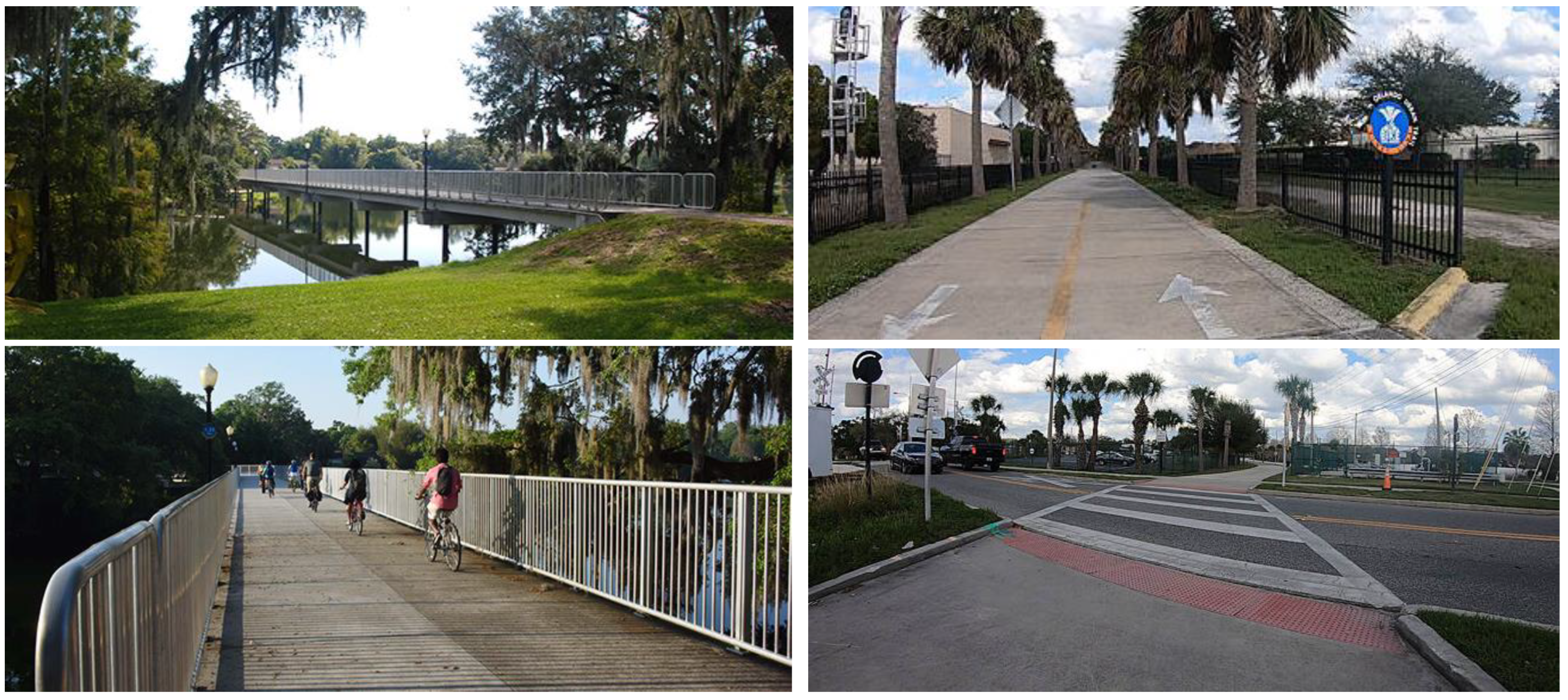
The Orlando Urban Trail functions as a dynamic connector, meandering through diverse neighborhoods in the heart of Orlando, Florida (
Figure 7). Designed with a network of multi-use paths catering to both pedestrians and cyclists, this urban trail path spans various sections, establishing an inclusive and accessible route for both residents and visitors. Extending across the city, the trail path interconnects parks, cultural sites, and residential areas, thereby cultivating a sense of community and bolstering neighborhood connectivity. Noteworthy among its features is its pivotal role in promoting active transportation, providing an alternative and sustainable mode of commuting throughout the city. The trail’s diverse lengths accommodate users of all ages and abilities, rendering it a versatile space for recreational activities, exercise, and leisurely strolls.
As the Orlando Urban Trail meanders through the urban fabric, it serves not only as a physical connector of neighborhoods but also as a substantial contributor to the city’s dynamic atmosphere. Beyond its utility as infrastructure, the trail path fosters opportunities for community engagement, hosts events, and cultivates a collective urban identity. Through its promotion of a healthier lifestyle, encouragement of outdoor recreation, and establishment of vital links between key areas of the city, the Orlando Urban Trail stands as a testament to the city’s steadfast commitment to augmenting the well-being and connectivity of its neighborhoods [
94].
6. Discussion
The 15-minute city represents a micromobility-focused urban planning concept designed to enhance the livability and humanity of metropolitan areas. Micromobility within the context of 15-minute cities can serve as an independent transport mode for short-distance trips, typically ranging from 3 to 5 kilometers. Alternatively, it functions as a first/last-mile solution when integrated with public transportation systems. The significance of providing high-quality services in urban public transport systems cannot be overstated [
95]. Micromobility plays a pivotal role in reshaping mobility patterns, thereby fostering less car-centric and car-dependent transport systems and enhancing accessibility to services and facilities [
57].
Simultaneously, micromobility holds substantial potential in connecting 15-minute neighborhoods, either autonomously or in conjunction with public transportation, forming an integral part of a comprehensive and integrated transportation network. Through this approach, individuals gain access to facilities, amenities, workplaces, recreational activities, and other utilities not encompassed within their immediate 15-minute city, promoting a more sustainable and car-independent mode of travel.
Urban trail paths, which constitute parts of greenways (as they are called in America) or green corridors (as they are called in Europe) possess distinctive characteristics that are particularly appealing to micromobility users when specific conditions are met. The sustained utilization of urban trail paths by micromobility users is contingent upon various factors, including safety, availability of facilities, amenities, and maintenance. Moreover, the natural beauty of trail paths serves as a significant attraction for visitors. Elements such as lighting, benches, shelters, and waste disposal facilities profoundly impact user experience and influence their decision to utilize these paths.
Several determinants, intertwined with the decision-making processes of micromobility users, contribute to the broader discussion. Safety assumes a central role in mobility considerations, with urban planning policies emphasizing its importance. Factors such as the existence of micromobility sharing systems, appropriate infrastructure, travel distance, topography, and weather conditions significantly influence the demand for micromobility. System-related considerations encompass convenience, economic viability, accessibility, ease of use, and service quality, among others.
Technologists and government officials are deliberating on the redesign of urban spaces to accommodate the increasing prevalence of e-scooters and other micro-vehicles. Urban trail paths present a promising solution for connecting communities in a more sustainable manner, but the success of such initiatives hinges on meticulous attention to specific considerations. Critical factors that warrant focused attention include the presence of shared micromobility vehicles, the accessibility of urban trail paths, the local topography, service quality, appropriate infrastructure, seamless integration with public transport, and the strategic placement of entry/exit points. Additionally, the number of connection points to public transportation is a pivotal determinant of success, influencing individuals’ decisions to utilize trail paths as a means of connecting neighborhoods. Efforts directed towards optimizing these factors will play a pivotal role in ensuring the efficacy of urban trail paths as a viable and sustainable means of community connectivity.
Urban trail paths do not serve merely as recreational corridors for the leisurely exploration of tourist attractions or engaging in recreational activities. Under conducive conditions, these pathways can facilitate widespread use, particularly by commuters seeking to connect multiple 15-minute cities or neighborhoods. Consequently, meticulously planned and designed urban trail paths can be perceived as gateways influencing land-use patterns in areas that traditionally support automobile-dependent lifestyles. Analysis of the literature and case studies demonstrates that urban trail paths serve as connectors in the context of 15-minute cities, thereby enhancing various aspects of sustainability. This enhancement encompasses social, environmental, health, and economic benefits.
The authors argue that an exploration of the integration of micromobility and urban trail paths within the framework of 15-minute cities demands a comprehensive research approach. Vital components of this approach involve understanding user preferences, implementing safety measures, and evaluating economic impact through a social cost–benefit analysis of such integrated systems. Examining the integration of micromobility with public transport and assessing its impact on land-use patterns can provide valuable insights. Environmental sustainability, tailored policy recommendations for city planners, and community engagement are pivotal aspects of the successful implementation of these concepts. Extracting lessons from case studies of cities with successful micromobility initiatives and urban trail paths can offer practical guidance. Furthermore, additional research exploring long-term effects on sustainability, livability, and resilience within 15-minute cities will contribute to a holistic understanding of these transformative urban planning concepts.
7. Conclusions
The incorporation of urban trail networks as linkages between residential areas through micromobility signifies a paradigmatic shift in urban planning, aligning with the tenets of the 15-minute city model. This strategic methodology addresses the evolving requirements of urban inhabitants by prioritizing elements such as accessibility, sustainability, and community well-being. Micromobility, specifically within the framework of the 15-minute city, operates as a dynamic force, restructuring patterns of mobility and diminishing reliance on automobiles for short-distance travel.
Urban trail paths, integral elements of greenways, assume paramount importance, providing appealing routes for micromobility users. The success of this integration hinges on various factors, encompassing the availability of shared micromobility, the quality of infrastructure, and connections with public transportation. Economic impact assessment, environmental considerations, and community involvement augment the advantages of this transformative approach.
Through comparative case studies, it becomes evident that well-designed urban trail paths act as effective connectors, influencing land-use patterns and fostering a shift towards sustainable, car-independent urban lifestyles. As urban spaces adapt to accommodate micromobility, these paths emerge as pivotal elements, cultivating vibrant and interconnected communities and thereby steering cities towards a more livable and humane future.


