Article

Spatial–Temporal Coupling Analysis of Land Use Function and Urban–Rural Integration in Heilongjiang, China

1
School of Public Administration and Law, Northeast Agricultural University, Harbin 150030, China
2
College of Economics and Management, Northeast Agricultural University, Harbin 150030, China
*
Author to whom correspondence should be addressed.
Land 2023, 12(12), 2152; https://doi.org/10.3390/land12122152
Submission received: 15 October 2023 / Revised: 23 November 2023 / Accepted: 7 December 2023 / Published: 11 December 2023
(This article belongs to the Special Issue Agricultural Land Use and Rural Development)

Abstract

:
Urban–rural integration relies on the rational flow of factors between urban–rural areas. Land represents a closely related factor between urban–rural areas, so the effective utilization of land resources can promote the flow of urban–rural factors. Therefore, there is a certain correlation between land use function and urban–rural integration. The purpose of this study is to explore the coupling and coordination relationship between the two systems and to find out the spatial–temporal differentiation characteristics in the process of land use function and urban–rural integration. The main conclusions are as follows: (1) The comprehensive level of land use function and urban–rural integration in Heilongjiang Province shows an overall upward trend, but there is a large differentiation on a municipal scale. (2) The coupling coordination degree of the two systems in Heilongjiang Province shows a spatial distribution pattern of “high in the north and low in the south, high in the middle and low in the east and west”. From 2013 to 2022, except for Harbin and Yichun, the overall trend in other regions is gradually upward. (3) The obstacle degree analysis of land use function and urban–rural integration in Heilongjiang Province shows that there is a close correlation of obstacle factors between the two systems.

1. Introduction

An enormous gap exists between rural and urban areas [1]. On average, people in urban areas have more job opportunities and better access to education, safe drinking water, health services, and high-quality infrastructure than rural populations. As a result, at least 80 percent of people living in poverty are found in rural areas, even though rural areas account for only 45 percent of the world’s population [2]. Inequalities related to location—also known as “spatial inequalities”—can be extreme between rural and urban areas, especially in developing countries. According to the United Nations, the scope of adequate sanitation in the rural areas of developing countries has increased from 26% in the 1990s to 52% in the 2010s and from 47% to 82% in urban areas during the same period. Therefore, significant progress has been made in this particular aspect in rural areas, but they still lag far behind urban areas. Furthermore, the same holds true for other issues such as secondary school attendance and electricity [3]. A large rural–urban gap may lead to social division, rural dissatisfaction, and even unrest in some countries [4]. In summary, an urban–rural integration (URI) development strategy is designed to solve the urban–rural gap during the process of rapid urbanization and industrialization [5].
URI promotes the free flow of labor, land, capital, and other factors between urban–rural areas [6], such that URI helps to achieve the balance of urban–rural economic development and social equality [7]. URI development emphasizes multi-scale, multi-field, and all-round infiltration and integration. Land is the spatial carrier of an urban–rural regional system [8,9]. Land is also the most basic and important medium for the circulation and allocation of various elements between urban–rural areas while promoting the development of URI. The land use function (LUF) refers to the products and services that can be provided for human beings through land use [10]. LUF is a mirror reflecting the stage of urban–rural socio-economic development [11,12]. Meanwhile, a reasonable LUF is an important method for solving various problems in the process of URI development. LUFs have changed significantly during the development of URI [13]. The change affects the multi-dimensional integration of the urban–rural economy, society, and ecology [14,15,16]. In this vein, assessing the interaction between LUF and URI is of vital importance to the development of urban–rural integration.
China is experiencing the same unbalanced urban–rural development as developed countries have experienced [17,18]. The urban–rural dual land management system in China has led to contradictions such as urban–rural segmentation and lagging rural development [19,20]. Since the reform and opening up policy, the average urban–rural income ratio was 2.57 in 1978, reached a peak of 3.11 in 2010, and narrowed to 2.56 in 2020 [4]. In order to coordinate urban–rural development, China has successively put forward strategic plans for URI development, for instance, “Rural Revitalization” and the establishment of national pilot areas for integrated urban–rural development. The implementation of the above measures depends on the adequate fulfillment of LUFs. For the sake of URI development, the interaction between URI and LUF needs to be coordinated, and the dynamic trade-offs in both spatial and temporal dimensions need to be explored, thereby enhancing the overall benefits [21]. The speed of URI in the northeast of China is significantly slower than in other regions [22]. Heilongjiang Province in the northeast of China is the sixth largest province in China. It is the ballast stone for China’s food security and an important old industrial base. Thus, this study has taken Heilongjiang Province as an example to analyze the relationship between LUFs and URI.
Extant research has made progress in URI [23,24,25,26]. The evaluations of the URI level mainly adopt three types of indicators: comprehensive indicators, comparative indicators, and catch-up indicators [4]. The influencing factors cover the multi-dimensional coordinated development evaluation of urban–rural economy, society, and ecology [27]. The analysis of the spatial pattern of URI included spatial auto-correlation analysis [28], the Markov chain model [29], hot spot analysis [30], and other methods. In terms of LUF, the conception was originally defined as the function of cultivated land production [31]. The SENSOR project has expanded the LUF to the three most closely related economic, environmental, and social levels in the region. It has been widely recognized by the international academic community [32]. At present, China’s land spatial planning divides LUFs into production, living, and ecological functions [33]. LUFs are affected by regional natural resource endowments, socio-economic conditions, and policy factors, resulting in spatial and temporal changes [34]. The evaluation process of LUFs has undergone a transformation from static analysis to dynamic simulation [35]. The evaluation index system with social, economic, and ecological dimensions is constructed [36,37] based on the support of investigation and statistical data so that LUFs are comprehensively and quantitatively evaluated [38]. After the quantitative evaluation of land use versatility, the results are expressed by spatial analysis technology or a mathematical model [39].
Notably, although extant research provides extensive theoretical research and empirical analysis on LUFs [9,40,41] or URI [42,43,44], few studies have focused on the relationship between LUFs and URI. The existing study between URI and LUFs mainly focuses on the relationship between similar topics such as industrial integration and URI or the transformation of land use and the optimal allocation of land use from the perspective of urban–rural integration. Moreover, LUF and URI are complicated systems that involve many factors. The compositive research method on the measurement of URI and LUF should be used. We contend that LUF, in addition to directly influencing the level of URI, may also have indirect effects on URI by influencing industrial structure, urbanization level, and infrastructure and public services’ accessibility. In line with this reasoning, examining and comparing the spatio-temporal coupling characteristics of LUF and URI could provide new insights into the paths to achieve regional URI.
We focus on exploring the spatial–temporal coupling analysis between land use function and urban–rural integration, selecting Heilongjiang Province in China as the research area for empirical analysis, so as to answer two questions: “What spatial–temporal characteristics are LUF and URI?” and “How is coupling coordination degree between LUF and URI?” We provide a methodological contribution for quantitatively measuring the level of URI and LUF and the coupling coordination between LUF and URI, and we expose a theoretical model based on the element–structure–function perspectives in analyzing the relationship between LUF and URI. It is helpful to explore the roles of LUF in achieving URI.
In a nutshell, this research aims to assess the coupling level and the spatial–temporal difference between URI and LUF in Heilongjiang Province at the city level. Firstly, we construct a theoretical framework of the coupling analysis of URI and LUF, with the inclusion of indicators specifically reflecting urban–rural linkages and land use functions. Secondly, due to the limitations of the statistical data availability, we conduct an empirical analysis using city-level data from 2013, 2017, and 2022. Thirdly, the evaluations of LUF and URI are explored with the comprehensive index model and the spatial–temporal characteristics are analyzed. Then, the analysis of the coupling and coordination degree between LUF and URI is explored with the coupling coordination degree model, as well as the spatial–temporal characteristics. Fourthly, we analyze the obstacle degree of LUF and URI in Heilongjiang Province. Finally, the coupling regional difference between URI and LUF is identified to reveal the current development status and challenges faced by specific regions in URI. We hope that our findings will shed light on the relationship between URI and LUF and provide help to other countries in achieving the coordinated development of URI and LUF.

2. Theoretical Framework and Methods

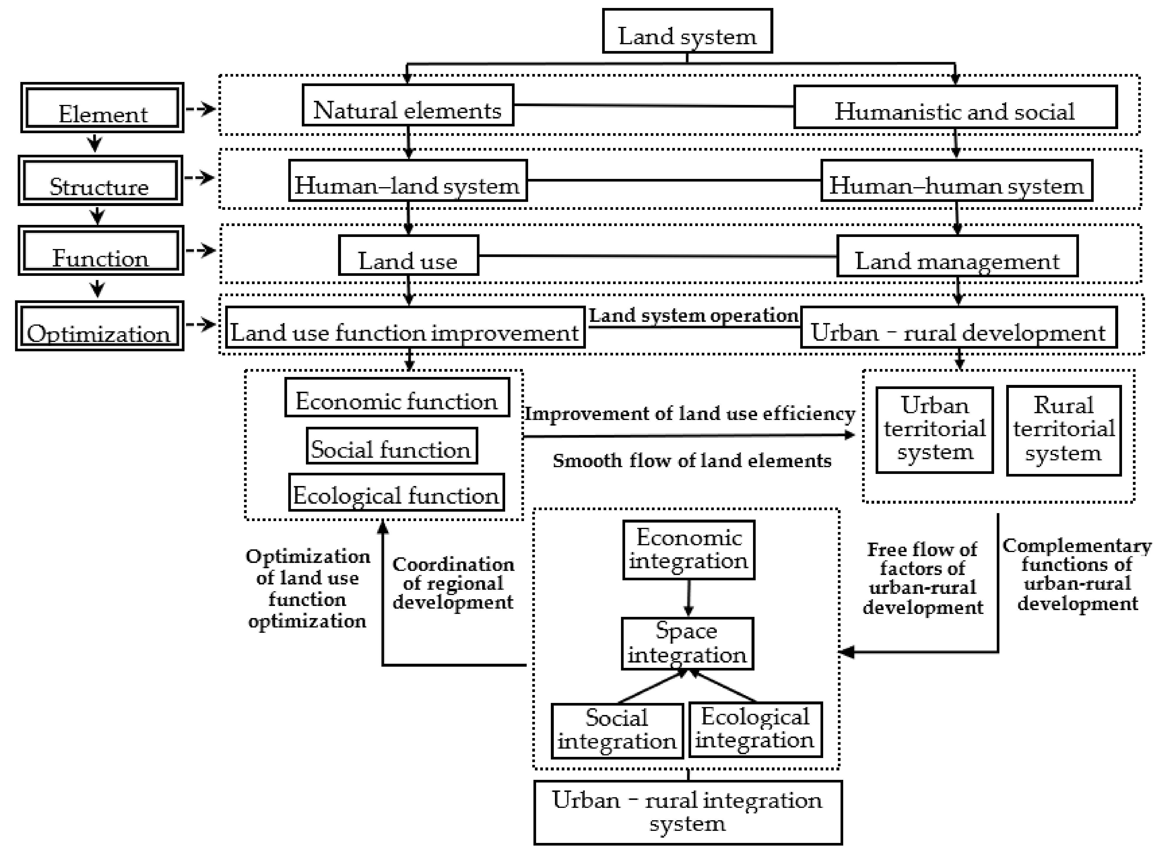
2.1. Theoretical Framework

The land system is the interface between human society and the natural environment, so it is a typically complex system [45]. The land system consists of natural, humanistic, and social elements. All the elements form specific structures and functions. The land use and land management functions in the land system interact to promote the operation of the land system. Land is the core element and the spatial support for urban–rural development [46]. The social, economic, and ecological transitions of land use cause the land system to experience a drastic, unbalanced evolution [47]. There is a coupling trend and law between the changes in the land system and the evolution of urban–rural relations in China [48]. The land use function is closely related to the operation of the land system, and it affects the operation of the land system. Consequently, it affects the allocation of urban–rural factors, urban–rural regional structure, and urban–rural development functions [49]. The function of land use corresponds to the stage of urban–rural integrated development. Controlling the land use function and regulating the operation of the land system can effectively alleviate the problems in the process of urban–rural integrated development.
On the one hand, the land use function affects urban–rural integration. The inefficient utilization of land, such as the urban bias toward land appreciation income and the obstructed circulation of land factors, has increased the urban–rural division. Nowadays, the food and ecological security functions of rural land use have increased, while the social security and economic functions have shown a downward trend [50,51]. The intensive level of urban land use has been greatly improved, and the economic function has been significantly improved [52]. The improvement in land use function is conducive to realizing the optimal allocation of land resources in urban–rural areas. On the other hand, the evolution of the urban–rural relationship has driven the optimization of the land use function. With urbanization’s high-quality development, the spillover effect from urban areas to rural areas gradually appears. Rural land value can be promoted by the development of marketization and industrialization. The restructuring of the global economy and the upgrading of industrial structures require China’s development to keep up with the pace. Rural areas have become a new development space and growth point [53]. The reshaping of the new urban–rural economic, social, ecological, and spatial relations has become an important development direction that will improve the comprehensive function of land use to meet the new development needs.
URI and LUF involve various aspects of socio-economic development. The study of the relationship between URI and LUF entails an integrated framework. To that end, we draw from the previous literature to establish the main theoretical constructs. The influencing factors of URI are explored from four dimensions: urban–rural economic integration, urban–rural social integration, urban–rural spatial integration, and urban–rural ecological integration [4,27,54,55]. The influencing factors of LUF are explored via a complex coupling system formed by three dimensions: economic function, social function, and ecological function [36,37,56,57]. The interaction between the urban regional system and the rural regional system shows that the process of URI development is the process of the continuous release of LUF. URI development is hindered by the low efficiency of land resource utilization and the prominent contradiction between land and humans; in contrast, it is improved by new types of urbanization and rural revitalization. The mechanism between URI and LUF includes the following three aspects. Firstly, URI means urban–rural economic integration, which drives the improvement in the economic function of regional land use [58]. Hence, it is necessary to acknowledge the above close connection. The higher the level of economic factors in URI and LUF, the more prosperous the urban–rural regional system. Secondly, rural areas are typically at a disadvantage in terms of regional social development [3]. The public service level and people’s living standards should be promoted in the process of URI, and rural areas should also share convenient and efficient social services. To promote the social level of URI, the social function of regional land use should be improved [19]. Finally, the urban-centric development strategy leads to a concentration of economic and social elements in the cities and, at the same time, the destruction of the ecological environment. Green development and ecological civilization ideas provide opportunities for the ecological function of urban–rural land use to fulfill its role. In addition, the improvements in the ecological function of regional land use can equalize urban–rural ecological environmental development and realize the sustainable prosperity and well-being of both urban and rural areas. Urban–rural economic, social, and ecological integration are interrelated to form urban–rural–spatial integration (Figure 1).

2.2. Measuring the Level of LUF and URI with the Comprehensive Index Model

The comprehensive index model method constructs the value function by integrating multiple individual indexes of different objects, forming a general index, and then achieving the purpose of evaluation through index comparison. Its fundamental idea is to transform the diversified index into an index that can reflect the comprehensive situation that requires evaluation. We used the comprehensive index model to evaluate the development level of LUF and URI in Heilongjiang Province in 2013, 2017, and 2022.
Firstly, a comprehensive exponential equation was determined. The calculation formula is as follows:
W = j = 1 p A i j Q j ( i = 1 , 2 , , R ; j = 1 , 2 , , P )
where W is the comprehensive index of the land use function or urban–rural integration of the measurement object; i is the evaluation object; j is the evaluation index; R is the number of evaluation objects; P is the number of evaluation indicators; A i j is the standardized value of the evaluation index of the i th evaluation object; and Q i j is the weight value of the evaluation index.
Secondly, the evaluation index system (LUF and URI) was constructed. Integrating the analytical framework, previous studies, and the land use situation in Heilongjiang Province, the level of LUF was evaluated by using the index system, including the three-dimensional land multi-functional spatial structure of “economy-society-ecology”. For each land use function, the corresponding indicators were selected for quantitative measurement, and the evaluation index system of multiple utilization was constructed (Table 1). The selection of these indicators is mainly based on the following criteria: (1) the indicators are closely related to the functional connotation of land use; (2) the indicators have been applied in previous studies; (3) the indicators are quantitatively measured at a municipal scale; and (4) the indicators are holistic, dominant, and normative.
Based on the theoretical framework, the rural revitalization of the total goal, and “The urban and rural integration development system mechanism and policy system opinions”, the evaluation index system of URI included the economic integration, social integration, spatial integration, and ecological integration of the urban–rural area. Then, the current study selected 14 indicators to construct the evaluation index system of urban and rural integrated development level (Table 1).
Thirdly, the index data were processed dimensionlessly. When calculating the evaluation index, the data of different indexes were different, so dimensionless treatment was needed. We used the maximum difference normalization method for data standardization and obtained the data normalization matrix.
Finally, the coefficient of variation method was used to determine the weight of the evaluation index. Compared with other methods such as the analytic hierarchy process, Delphi process, and fuzzy analysis method to determine the index weight, the coefficient of variation method has the advantages of strong references, wide applicability, ease of understanding and implementation, and provides robust objectivity, which is widely used in the process of the actual index weight determination.
The mean X i j ¯ and standard deviation S i j were calculated from the normalized values:
X i j ¯ = 1 R i = 1 R X i j
S i j = 1 R i = 1 R ( X i j X i j ¯ ) 2 1 2
The coefficient of variation C V was calculated for each index:
C V = S i j X i j ¯
The specific weights are shown in Table 1.

2.3. Analysis of the Coupling and Coordination Degree between LUF and URI

(1)
Coupling coordination degree model
“Coupling“ means that two or more systems achieve the effect of coordinated development through interaction and influence. Under the interaction of each subsystem, they show a relationship of mutual influence and mutual restriction. The closer the system is, the stronger the coupling is. The coupling degree is a measure that comprehensively considers the degree of the interaction of each subsystem [59].
Firstly, LUF and URI levels were regarded as two systems, and the coupling relationship between them was analyzed by the formula:
C P = 2 W T ( W + T ) 2
In the formula, C P is the coupling degree of land use function and urban–rural integration level. The larger the C P value, the higher the coupling degree. W is the comprehensive index of land use function, and T is the comprehensive index of urban–rural integration level.
Secondly, the coordination degree was calculated. The calculation focused on the application of quantitative methods to evaluate the degree of closeness of the interaction between LUF and URI systems, which effectively reflected the degree of coordination of the development level of each coupling system. The formula is:
C D = C P × N
where N = α W + β T .
In the formula, C D is the coupling coordination degree of the two systems of land use function and urban–rural integration level, and 0 ≤ CD ≤ 1. The larger the C D value is, the higher the coordination degree of the interactive coupling between land use and urban–rural integration level will be. N is the comprehensive coordination index of the synergistic effect of the two systems. α and β are undetermined coefficients, and the sum is 1. This paper only studies the two subsystems of land use function and urban–rural integration level, so the two are equally important, therefore α = β = 0.5 .
(2)
Coupling coordination stage and type division
The relative development degree model reflects the land use function and the level of urban–rural integration [60], as shown in the following formula:
R = W / T
In the formula, R is the relative development degree coefficient, W is the comprehensive index of land use function, and T is the comprehensive index of urban–rural integration level.
W divides the coupling and coordination status of the municipal land use function and urban–rural integration level system in Heilongjiang Province into 10 types (Table 2).

2.4. Obstacle Degree Model

In order to find out the obstacle factors that restrict the LUF and URI, we have constructed the obstacle factor model to analyze them. The obstacle degree model was analyzed and evaluated by using the indexes of the “index deviation degree (Qij)” and “obstacle degree (Mij)” indicators. The model is as follows [61]:
Q i j = 1 X i j
M i j = W j × Q i j i = 1 n W j × Q i j
where Xij is the single index standardized value; Wj is the weight of the j index; and Mij is the obstacle degree for the URI and LUF of the i indicator. The larger the value of Mij, the greater the obstacle degree of the indicator to the target.

2.5. Study Area and Data Sources

2.5.1. Study Area

In Heilongjiang Province, the cities comprise Harbin and 12 other cities and the Daxing‘anling region. It is a major agricultural province and an important old industrial base. These factors lay the foundation for URI development. The total land area of the province is 473,000 km2, ranking sixth in the country. The main mountainous areas with high forest coverage are in the northwest, north, and southeast of Heilongjiang Province. Heilong River, Wusuli River, Songhua River, and Suifen River form the four major water systems. There are 253 lakes with a perennial water surface area of more than 1 km2. The Nenjiang River and Songhuajiang River run through the whole province from southwest to north to form the Sanjiang Plain in the northeast and the Songnen Plain in the southwest. The proportion of cultivated land, forest land, water wetland, and grassland in Heilongjiang Province is 35%, 45.9%, 7.4%, and 2.5%, respectively, in 2022 (Figure 2).

2.5.2. Data Sources

As the basic administrative unit in China’s administrative divisions, the city is the most commonly used statistical data unit in current statistical departments. At the same time, we also considered data integrity and accessibility. Therefore, the study takes the municipal level in Heilongjiang Province as the research unit. Based on the development status of Heilongjiang Province and considering the availability of data, the years 2013, 2017, and 2022 were selected as the study points and 2013–2022 as the study period.
This paper studies the functional level of land use management and the level of urban–rural integration development with two types of social and economic survey data and land use data. The social and economic survey data mainly include the statistical Bulletin of National Economic and Social Development of Heilongjiang Province in 2013, 2017, and 2022 and the statistical Yearbook of Heilongjiang Province and other cities; the land use data are the survey data of land use change in Heilongjiang Province. In view of the missing data, this paper mainly uses the mean method, reference method, and other methods for supplementary processing.

3. Results Analysis

3.1. Evaluation of LUF

3.1.1. Temporal Variation Characteristics of LUFs

From 2013 to 2022, the comprehensive index of LUFs in Heilongjiang Province showed an overall upward trend, but there was a large gap between the regions (Figure 3). The fastest improvement in land use comprehensive function was in Daxing’anling, which increased from 0.048 in 2013 to 0.738 in 2022, an increase of 15 times; other areas basically show a uniform upward trend.
From 2013 to 2022, the land use function of Heilongjiang Province generally showed a trend of “ecological function > social function > economic function”, in which ecological function and social function were dominant (Figure 4). The economic function was generally low. The economic function in Harbin is the most prominent, having experienced a trend of first increasing and then decreasing. The social function continued to increase. The social functions of Jiamusi, Qiqihar, Heihe, Suihua, Jixi, Shuangyashan, and Mudanjiang showed the fastest growth. The ecological function showed an overall growth trend. Compared with the above two functions of land use, the ecological function had an absolute advantage and was dominant.

3.1.2. Spatial Pattern Distribution Characteristics of LUFs

By constructing the evaluation index system of LUFs, the single index of LUFs and the comprehensive index in 13 cities and regions in 2013 and 2022 were calculated. According to the standard deviation method, LUF indexes in Heilongjiang Province were divided into five levels. These reflected the spatial distribution characteristics and trends in LUF levels.
(1)
The spatial distribution characteristics of LUF
From 2013 to 2022, the comprehensive LUF in Heilongjiang Province showed a spatial distribution pattern of “high in the west and low in the east, high in the north and low in the south“, showing a gradually decreasing trend from the western and northern cities to the southeast and southwest (Figure 5a–c).
The economic LUF remained stable, and the economic LUF in Harbin was the most prominent across the study’s time period (Figure 5d–f). The distribution of the social LUF showed the pattern of “high in the west and east”. The distribution scale of high social LUF in the west decreased, but the level improved. The distribution of social LUF in Yichun city decreased significantly. The distribution in Hegang City increased slightly (Figure 5g–i). The ecological LUF showed a pattern of “high in the northwest and east”, which was located in the distribution of the Greater Khingan Mountains, Lesser Khingan Mountains, and Sanjiang Plain. The ecological LUF in Mudanjiang significantly weakened. The ecological LUF in the Daxing’anling area decreased and then increased (Figure 5j–l).

3.2. Evaluation of URI

3.2.1. Temporal Variation Characteristics of URI Level

From 2013 to 2022, the composite level of URI in Heilongjiang Province generally showed an upward trend. The areas with rapid growth were Yichun, Shuangyashan, and Hegang City. The highest composite level of URI in Heilongjiang Province was Harbin City. The level of URI development was divided into two stages: in the first stage (2013–2017), the level of URI developed slowly. During this period, although the intensity of rural construction increased and the number of rural preferential policies increased (except for Harbin, which had a good foundation for URI) the growth rate of other cities was basically flat or slightly improved, and Heihe declined. The second stage (2017–2022) was a rapid growth period of urban–rural integration development. With the efficient promotion of the rural revitalization strategy and the rapid development of urbanization, the rural population continued to shift to the large cities, the population urbanization and the non-agricultural employment population continued to rise, the development of the second and third industries in urban and rural areas was good, and the level of urban–rural integration development was growing rapidly (Figure 6).
From 2013 to 2022, the economic development levels of URI in Heilongjiang Province were on an upward trend but were at the lowest compared with the other three indexes. The economic development in Harbin was the most prominent and experienced a process of increase. The social and spatial integration of URI in Heilongjiang Province showed a stable trend. The social integration was higher than the spatial integration of URI. The ecological level of URI in Heilongjiang Province showed an overall growth trend. Compared with the above three indexes, the ecological one increased most rapidly and has already become the dominant one in 2022 (Figure 7).

3.2.2. Spatial Pattern Distribution Characteristics of Urban–Rural Integration Level

According to the standard deviation method, the URI indexes of cities in Heilongjiang Province were divided into seven levels. This reflected the spatial distribution characteristics and trends of URI. From 2013 to 2022, the level of urban–rural integration in Heilongjiang Province showed spatial distribution characteristics of “high in the middle and low in the east and west, high in the south and low in the north”. The level of URI in Daqing and Harbin was generally higher than the average level of other cities (Figure 8a–c). The spatial distribution of urban–rural economic integration changed from a pattern of “high in the northwest and in the southeast” to that of most areas improving, except for Qiqihar and Suihua City (Figure 8d–f). The spatial distribution of urban–rural social integration showed no evident changes. The urban–rural social integration in Harbin kept its remarkable status from beginning to end. Qiqihaer, Jiamusi, and Suihua cities slightly increased. The other areas remained stable (Figure 8g–i). The spatial distribution of urban–rural space integration was mainly concentrated in areas except for the north of Heilongjiang Province (Daxing’anling, Heihe, and Suihua). Qiqihaer, Jiamusi, and Mudanjiang cities slightly increased. The other areas remained stable (Figure 8j–l). The spatial distribution of urban–rural ecological integration showed a pattern of “high in the northwest and east”, which was similar to that of ecological LUF (Figure 8m–o).

3.3. Evaluation of Coupling Coordination Degree between Land Use Function and Urban–Rural Integration Level in Heilongjiang Province

3.3.1. Time Series Characteristics of Coupling Coordination between Land Use Function and Urban–Rural Integration Level

The coupling coordination degree and relative development degree of land use function and the urban–rural integration level system of Heilongjiang prefecture-level cities in 2013, 2017, and 2023 were calculated (Figure 9). From 2013 to 2022, the coupling and coordination levels of land use function and urban–rural integration level showed an increasing trend. From 2013 to 2017, the level of coupling and coordination between the two increased slowly; from 2017 to 2022, the level of coupling and coordination between the two entered a period of rapid development. From 2013 to 2022, the areas with an increase in the coupling coordination level above 0.1 were Daxing’anling, Heihe, Jiamusi, Suihua, Shuangyashan, and Qiqihar. The largest increase was Daxing’anling, reaching 0.37, followed by Heihe and Jiamusi, both of which were 0.19.

3.3.2. Spatial Pattern Distribution Characteristics of Coupling Coordination between Land Use Function and Urban–Rural Integration Level

According to Table 2, the evaluation results are divided into stages (Table 3), and the spatial evolution pattern of coupling and coordination of the two systems in each district and county in 2013–2023 was obtained (Figure 10).
From Table 3 and Figure 10, it can be seen that from 2013 to 2022, the coupling and coordination of land use function and urban–rural integration level in Heilongjiang Province presented distinct spatial and temporal distribution characteristics, mainly as follows:
From the perspective of the coupling coordination degree of the whole province, the coupling coordination degree of the two systems showed a spatial distribution pattern of “high in the north and low in the south, high in the middle and low in the east and west”, and during 2013–2022, except for Yichun and Harbin, the overall trend was gradually upward. However, except for the first promotion to moderate coordination in the Daxing‘anling area in 2022, other cities were in states of being in serious disorder, moderate disorder, mild disorder, and on the verge of disorder, and there was a large scope for improvement. Among them, the coupling degree of Yichun and Harbin was generally higher than the coupling coordination level of the two systems of other cities in Heilongjiang, and the change was relatively stable. However, the level was still on the verge of disorder, and there was a large scope for improvement. In Suihua City in Heilongjiang Province, the level was more speedily enhanced, such that from 2013, when it seriously lagged behind the other cities in Heilongjiang Province, it was logged at first in the serious disorder stage then progressed to the mild disorder stage. The overall coupling degree of the Daxing‘anling region showed an increasing trend, and in 2022, its coupling degree rose to a moderate coordination stage. Hegang, Mudanjiang, and Daqing were in the stage of mild disorder from 2013 to 2022, and improvement was slow. The coupling coordination degree of Shuangyashan City, Qitaihe City, and Jixi City increased from the moderate disorder stage to the mild disorder stage. The coupling coordination degree of Jiamusi City increased from the moderate disorder stage to the stage of being on the verge of disorder. From 2013 to 2022, the improvement in Shuangyashan City, Qitaihe City, and Jixi City was basically in a state of synchronous optimization. In 2013, Heihe City and Qiqihar City were at the stage of moderate disorder, but the coupling coordination degree of Heihe City was better than that of Qiqihar City. By 2022, Heihe City was upgraded to the stage of being on the verge of disorder, while Qiqihar City was upgraded to the stage of mild disorder.

3.4. Obstacle Degree of LUF and URI

The main obstacle factors affecting the land use function in Heilongjiang Province came from L7 (pollutant discharge reduction), L2 (non-agricultural production), and L4 (social guarantee) in the element layer. There were spatial differences in the obstacle factors, and the sequence of obstacle factors in the same district changed with time: the districts where L7 was the first obstacle factor included the developed industrial cities (Qiqihar and Daqing). It also included the resource-based districts (Jixi, Shuangyashan, Qitaihe, and Hegang), farmland concentrated distribution districts (Jiamusi and Suihua), and the economic center (Harbin). The districts where L2 was the first obstacle factor were located in the Greater Khingan Mountains and the Lesser Khingan Mountain regions (Yichun, Heihe, and Daxing‘anling). The second obstacle factor was basically concentrated in L2, and the third obstacle factor was mainly concentrated in L4 (Figure 11).
The main obstacle to urban–rural integration development came from U4 (public services integration), U8 (pollutant discharge reduction), U6 (traffic integration), and U2 (investment integration) in the element layer. Except for Harbin, the first obstacle factor in all regions was U4. The second obstacle factor in each region mainly focused on U8 and U6. The third obstacle factor in each region was mostly concentrated on U2 (Figure 12).

4. Discussion

4.1. Understanding of Coupling and Coordination Degree between LUF and URI

This study was based on the angle of view of the element–structure–function of land system operation. The land use function interacted with the urban–rural development [48]. The key point of URI development was not the spatial evenness but the achievement of a reasonable urban–rural flow and the efficient allocation of production factors such as land [15]. The analysis of the coupling and coordination degree between LUF and URI has significant meaning in promoting the coordination, fairness, and sustainability of regional development [20].
According to the results, there was a coupling relationship between LUF and URI in Heilongjiang Province, and the level of coupling coordination was significantly improved during the study period. Whether it relates to the promotion of LUF or the implementation of a URI development strategy, it will involve economic, social, ecological, and other aspects. The process is complex and the task is arduous [19,33,34]. The analysis of the coupling relationship between LUF and URI is bound to be a complex process. The change in LUF affects the multi-dimensional integration of the urban and rural economy, society, and ecology [7,13]. To scientifically evaluate the degree of integration of LUF and URI and clarify the spatial and temporal pattern of LUF and URI is critical for the formulation of URI policies. More consistent development patterns and differentiated mechanisms can be analyzed and used as a reference for other countries and regions.
The obstacle factors that hinder the development of the two systems have a close association. The obstacle factors should be properly handled, so that the coordination degree of LUF and URI can be improved and the urban–rural area can attain healthy and sustainable development [62,63,64].

4.2. Recognition of the Spatial–Temporal Characteristics of URI and LUF

In order to scientifically analyze the relationship between LUF and URI, we creatively constructed index systems to measure the level of LUF and URI on the basis of the element–structure–function of land system operation. We provided a methodological contribution for the quantitative measurement of levels of URI and LUF and the coupling coordination between LUF and URI. In addition, we provided a theoretical model for analyzing the relationship between LUF and URI. The results confirmed that the change in LUF affects the multi-dimensional integration of the urban–rural economy, society, and ecology. It is the basis for improving the systems, mechanisms, and institutions related to URI.
As one of the major agricultural provinces in China, Heilongjiang Province faces the prominent contradiction of a dual urban–rural structure. Therefore, it is of great significance to accurately evaluate the level of urban–rural integration in Heilongjiang Province to identify and promote its urban–rural integration development [65]. The overall level of URI in Heilongjiang Province has increased, but the range is small. Although the research data and methods are different, this study is basically consistent with the research conclusions of other studies [66]. This is closely related to the economic downturn in Heilongjiang Province under the structural background of the reform of the supply side, the difficulties inherent in the transformation and upgrading of traditional industries, and the outflow of human resources. The analysis of URI levels in a typical area in China may provide a reference for other countries that are also facing similar problems in URI development.
The composite utilization of land in Heilongjiang Province is closely related to the changes in its social, economic, and ecosystem functions. The analysis of LUFs at the municipal level in Heilongjiang Province was basically consistent with the evaluation results of the land use system in Heilongjiang Province [62]. The multi-functionality of land use is helpful in realizing a smooth transformation and upgrading of regional social–economic development [56]. The analysis of LUFs can provide a scientific basis for the comprehensive optimal allocation of land resources and sustainable social and economic development in Heilongjiang Province and provide reference experience for other land-resource-based provinces [67].

4.3. Limitations and Future Prospects

We used the comprehensive index model method to evaluate the LUF and URI levels of various areas in Heilongjiang Province in 2013, 2017, and 2022 and analyzed the coupling and coordination relationship between the two systems. The evaluation systems of LUF and URI selected both direct indicators and relevant indirect indicators. Because of the diversification of LUF and URI paths, the index system should be perfected in the future to analyze the spatial–temporal characteristics and differentiation rules, with the objective of revealing the interaction relationship between LUF and URI. The systematic characterization of the degree of coupling and coordination could provide a useful solution for the implementation of the URI strategy in Heilongjiang Province. We chose the comprehensive index model for evaluation because the evaluation method is simple and easy to operate. The results of calculations objectively reflect the real situations. However, some positive indicators for the evaluation of LUF and URI were passively abandoned due to the difficulty of obtaining data. Meanwhile, due to data limitations, the flow of factors is not fully reflected. In the future, the construction of a multi-source heterogeneous database for LUF and URI should be further strengthened, and the index of primary mobility characteristics (flow scale, direction, speed, frequency, network connection) should be enhanced in order to more accurately depict the essential connotation of regional LUF and URI.

5. Conclusion and Policy Implications

5.1. Conclusion

The urban–rural dual land management system in China has led to contradictions such as urban–rural segmentation and lagging rural development. From the point of view of the land system, it is necessary to improve the utilization functions of urban–rural land resources for URI development. Taking Heilongjiang Province as the research region, this study analyzed the spatial–temporal coupling characteristics of LUF and URI from 2013 to 2022. The quantitative evaluation of the relationship between URI and LUF is a methodological contribution. The results show the following:
(1)
The comprehensive index of land use function in various regions in Heilongjiang Province showed an overall upward trend, but there was a large gap between the regions. The spatial distribution pattern is “high in the west and low in the east, high in the north and low in the south”. Overall, it showed a trend of “ecological function > social function > economic function”, and the change in land use function in Heilongjiang Province became more and more intense.
(2)
The overall level of urban–rural integration in Heilongjiang Province is on the rise. The spatial distribution characteristics show “high in the middle and low in the east and west, high in the south and low in the north”. Overall, there was a trend of “urban-rural ecology level > urban-rural public service level > urban-rural economic development level > urban-rural people’s living standard”.
(3)
The coupling and coordination level of LUF and URI in Heilongjiang Province showed an increasing trend, except for Yichun and Harbin. The coupling coordination degree of the two systems shows a spatial distribution pattern of “high in the north and low in the south, high in the middle and low in the east and west”.
(4)
The obstacle degree analysis of LUF and URI in Heilongjiang Province shows that there is a close correlation of obstacle factors between the two systems. Properly handling the factors hindering the development of LUF and URI can effectively promote the coordinated development of LUF and URI.
The spatial distribution of LUF, URI, and their coupling and coordination relationship in different areas of Heilongjiang Province under different natural geographical locations and social–economic conditions shows an obvious heterogeneity in different time periods. This provides the references for putting forward the exact path to promote URI development. The interaction relationship between LUF and URI in China is shared among many developing countries. Thus, studies on the relationship between URI and LUF in this typical area in China may provide a reference for other countries that are also facing similar problems in URI development.

5.2. Policy Implications

The comprehensive study of this spatial–temporal law and the obstruction factors arising from LUF and URI are helpful in suggesting targeted reform measures and promoting the sustainable and coordinated development of the regional social economy.
Firstly, the advantages of ecological function should be fulfilled. Those regions with good ecological conditions should seize the positive opportunities for constructing an ecological civilization to strengthen environmental protection. Furthermore, the regions that are surrounded by mountains should overcome the negative impact of the transportation system, accelerate the layout of public service facilities such as science, education, culture, and health, and improve the utilization efficiency of tourism resources. The further improvement in the coupling and coordination levels of LUF and URI should create the impetus for regional sustainable development.
Secondly, industrial upgrading should be performed to accelerate the speed of urban–rural integration development. There is extensive scope for improvement in the regions with stable coupling coordination levels of LUF and URI, such as Harbin and Yichun. These regions should take full advantage of new industrialization and agricultural modernization to update the second and third industries in the urban areas and revitalize the industries in the rural areas. The regions should improve output efficiency and add the value of industries to the process of improving urban–rural residents’ sense of acquisition.
Finally, the efficient flow of factors between urban and rural areas should be improved to optimize the relationship between LUF and URI. Policies to attract and encourage talent and investments in rural development should be enacted. The economic development gap between urban and rural areas is still the key factor affecting URI development, so support for rural areas should be increased. Rural advantages should be exerted to create new agricultural forms of commerce, such as rural e-commerce and the logistics industry. The integrated development model of production and marketing can reduce development costs and increase the economic benefits for farmers. Meanwhile, fair employment opportunities should be provided for urban–rural residents to narrow the income gap between urban and rural residents.

Author Contributions

Conceptualization, Q.L.; methodology, N.Z.; software, Y.Y. and L.W.; validation, N.Z. and Q.L.; formal analysis, Y.Y.; investigation, N.Z., L.W. and Y.Y.; resources, Q.L.; data curation, Y.Y.; writing—original draft preparation, N.Z.; writing—review and editing, N.Z., Y.Y., L.W. and Q.L.; visualization, N.Z. and Q.L.; supervision, N.Z. and Q.L.; project administration, N.Z.; funding acquisition, N.Z. All authors have read and agreed to the published version of the manuscript.

Funding

National Natural Science Foundation of China (41901208); China Postdoctoral Science Foundation (2021M700738); Heilongjiang Higher Education Teaching Reform Project (SJG20210079).

Institutional Review Board Statement

Not applicable.

Informed Consent Statement

Not applicable.

Data Availability Statement

The data supporting the findings of the study are available from the corresponding author upon request. But the national administrative boundaries and land use data are not publicly available.

Conflicts of Interest

The authors declare no conflict of interest.

References

  1. Sovacool, B.; Newell, P.; Carley, S.; Fanzo, J. Equity, Technological Innovation and Sustainable Behaviour in a Low-Carbon Future. Nat. Hum. Behav. 2022, 6, 326–337. [Google Scholar] [CrossRef] [PubMed]
  2. United Nations. Inequality in Asia and the Pacific in the Era of the 2030 Agenda for Sustainable Development; UN: New York, NY, USA, 2018; ISBN 978-92-1-363297-0. [Google Scholar]
  3. United Nations. World Social. Report. 2020: Inequality in a Rapidly Changing World; UN: New York, NY, USA, 2020; ISBN 978-92-1-004367-0. [Google Scholar]
  4. Pan, W.; Wang, J.; Li, Y.; Chen, S.; Lu, Z. Spatial Pattern of Urban-Rural Integration in China and the Impact of Geography. Geogr. Sustain. 2023, 4, 404–413. [Google Scholar] [CrossRef]
  5. Chen, K.; Long, H.; Liao, L.; Tu, S.; Li, T. Land Use Transitions and Urban-Rural Integrated Development: Theoretical Framework and China’s Evidence. Land. Use Policy 2020, 92, 104465. [Google Scholar] [CrossRef]
  6. Yang, L.; Fang, C.; Chen, W.; Zeng, J. Urban-Rural Land Structural Conflicts in China: A Land Use Transition Perspective. Habitat. Int. 2023, 138, 102877. [Google Scholar] [CrossRef]
  7. Zhu, J.; Zhu, M.; Xiao, Y. Urbanization for Rural Development: Spatial Paradigm Shifts toward Inclusive Urban-Rural Integrated Development in China. J. Rural Stud. 2019, 71, 94–103. [Google Scholar] [CrossRef]
  8. Long, H.; Tu, S.; Ge, D.; Li, T.; Liu, Y. The Allocation and Management of Critical Resources in Rural China under Restructuring: Problems and Prospects. J. Rural Stud. 2016, 47, 392–412. [Google Scholar] [CrossRef]
  9. Long, H.; Qu, Y. Land Use Transitions and Land Management: A Mutual Feedback Perspective. Land. Use Policy 2018, 74, 111–120. [Google Scholar] [CrossRef]
  10. Howe, C.; Suich, H.; Vira, B.; Mace, G. Creating Win-Wins from Trade-Offs? Ecosystem Services for Human Well-Being: A Meta-Analysis of Ecosystem Service Trade-Offs and Synergies in the Real World. Glob. Environ. Chang. 2014, 28, 263–275. [Google Scholar] [CrossRef]
  11. Wiggering, H.; Dalchow, C.; Glemnitz, M.; Helming, K.; Müller, K.; Schultz, A.; Stachow, U.; Zander, P. Indicators for Multifunctional Land Use—Linking Socio-Economic Requirements with Landscape Potentials. Ecol. Indic. 2006, 6, 238–249. [Google Scholar] [CrossRef]
  12. Verburg, P.; Overmars, K. Combining Top-down and Bottom-up Dynamics in Land Use Modeling: Exploring the Future of Abandoned Farmlands in Europe with the Dyna-CLUE Model. Landsc. Ecol. 2009, 24, 1167–1181. [Google Scholar] [CrossRef]
  13. He, W.; Li, X.; Yang, J.; Ni, H.; Sang, X. How Land Use Functions Evolve in the Process of Rapid Urbanization: Evidence from Jiangsu Province, China. J. Clean. Prod. 2022, 380, 134877. [Google Scholar] [CrossRef]
  14. Yang, Z.; Shen, N.; Qu, Y.; Zhang, B. Association between Rural Land Use Transition and Urban–Rural Integration Development: From 2009 to 2018 Based on County-Level Data in Shandong Province, China. Land 2021, 10, 1228. [Google Scholar] [CrossRef]
  15. Niu, X.; Liao, F.; Liu, Z.; Wu, G. Spatial–Temporal Characteristics and Driving Mechanisms of Land–Use Transition from the Perspective of Urban–Rural Transformation Development: A Case Study of the Yangtze River Delta. Land 2022, 11, 631. [Google Scholar] [CrossRef]
  16. Long, H.; Zhang, Y.; Ma, L.; Tu, S. Land Use Transitions: Progress, Challenges and Prospects. Land 2021, 10, 903. [Google Scholar] [CrossRef]
  17. Elshof, H.; Haartsen, T.; Van Wissen, L.J.G.; Mulder, C.H. The Influence of Village Attractiveness on Flows of Movers in a Declining Rural Region. J. Rural Stud. 2017, 56, 39–52. [Google Scholar] [CrossRef]
  18. Li, Y.; Westlund, H.; Liu, Y. Why Some Rural Areas Decline While Some Others Not: An Overview of Rural Evolution in the World. J. Rural Stud. 2019, 68, 135–143. [Google Scholar] [CrossRef]
  19. Liu, Y.; Li, Y. Revitalize the World’s Countryside. Nature 2017, 548, 275–277. [Google Scholar] [CrossRef] [PubMed]
  20. Niu, B.; Ge, D.; Sun, J.; Sun, D.; Ma, Y.; Ni, Y.; Lu, Y. Multi-Scales Urban-Rural Integrated Development and Land-Use Transition: The Story of China. Habitat. Int. 2023, 132, 102744. [Google Scholar] [CrossRef]
  21. Li, S.; An, W.; Zhang, J.; Gan, M.; Wang, K.; Ding, L.; Li, W. Optimizing Limit Lines in Urban-Rural Transitional Areas: Unveiling the Spatial Dynamics of Trade-Offs and Synergies among Land Use Functions. Habitat. Int. 2023, 140, 102907. [Google Scholar] [CrossRef]
  22. Wang, Y.; Liu, Y.; Li, Y.; Li, T. The Spatio-Temporal Patterns of Urban–Rural Development Transformation in China since 1990. Habitat Int. 2016, 53, 178–187. [Google Scholar] [CrossRef]
  23. Sheykhi, M. Rural—Urban Balance as a Measure of Socio-Economic Development with Special Reference to Iran. J. Soc. Econ. Res. 2016, 3, 1–12. [Google Scholar] [CrossRef]
  24. Ovaska, U.; Vihinen, H.; Oostindie, H.; Farinós, J.; Hrabar, M.; Kilis, E.; Kobal, J.; Tisenkopfs, T.; Vulto, H. Network Governance Arrangements and Rural-Urban Synergy. Sustainability 2021, 13, 2952. [Google Scholar] [CrossRef]
  25. Rickardsson, J. The Urban–Rural Divide in Radical Right Populist Support: The Role of Resident’s Characteristics, Urbanization Trends and Public Service Supply. Ann. Reg. Sci. 2021, 67, 211–242. [Google Scholar] [CrossRef]
  26. Lynch, K. Rural-Urban Interaction in the Developing World; Routledge Perspective on Development: London, UK; New York, NY, USA, 2005. [Google Scholar] [CrossRef]
  27. Liu, Y. Research on the Urban-Rural Integration and Rural Revitalization in the New Era in China. Acta Geogr. Sin. 2018, 73, 637–650. [Google Scholar] [CrossRef]
  28. Wu, X.; Cui, P. A Study of the Time–Space Evolution Characteristics of Urban–Rural Integration Development in a Mountainous Area Based on ESDA-GIS: The Case of the Qinling-Daba Mountains in China. Sustainability 2016, 8, 1085. [Google Scholar] [CrossRef]
  29. Liu, Y.; Lu, S.; Chen, Y. Spatio-Temporal Change of Urban–Rural Equalized Development Patterns in China and Its Driving Factors. J. Rural Stud. 2013, 32, 320–330. [Google Scholar] [CrossRef]
  30. Zhou, J.; Zou, W.; Qin, F. Review of Urban-Rural Multi-Dimensional Integration and Influencing Factors in China Based on the Concept of Equivalence. Geogr. Res. 2020, 39, 1836–1851, (In Chinese with English Abstract). [Google Scholar] [CrossRef]
  31. Andersen, P.; Vejre, H.; Dalgaard, T.; Brandt, J. An Indicator-Based Method for Quantifying Farm Multifunctionality. Ecol. Indic. 2013, 25, 166–179. [Google Scholar] [CrossRef]
  32. Paracchini, M.; Pacini, C.; Jones, M.; Pérez-Soba, M. An Aggregation Framework to Link Indicators Associated with Multifunctional Land Use to the Stakeholder Evaluation of Policy Options. Ecol. Indic. 2011, 11, 71–80. [Google Scholar] [CrossRef]
  33. Zhou, D.; Xu, J.; Lin, Z. Conflict or Coordination? Assessing Land Use Multi-Functionalization Using Production-Living-Ecology Analysis. Sci. Total Environ. 2017, 577, 136–147. [Google Scholar] [CrossRef]
  34. Baldwin, C.; Hamerlinck, J.; McKinlay, A. Institutional Support for Building Resilience within Rural Communities Characterised by Multifunctional Land Use. Land Use Policy 2023, 132, 106808. [Google Scholar] [CrossRef]
  35. Liu, J.; Li, J.; Qin, K.; Zhou, Z.; Yang, X.; Li, T. Changes in Land-Uses and Ecosystem Services under Multi-Scenarios Simulation. Sci. Total Environ. 2017, 586, 522–526. [Google Scholar] [CrossRef] [PubMed]
  36. Fan, Y.; Jin, X.; Gan, L.; Jessup, L.; Pijanowski, B.; Lin, J.; Yang, Q.; Lyu, L. Dynamics of Spatial Associations among Multiple Land Use Functions and Their Driving Mechanisms: A Case Study of the Yangtze River Delta Region, China. Environ. Impact Assess. Rev. 2022, 97, 106858. [Google Scholar] [CrossRef]
  37. Eric, F.; Patrick, M. Land Use Transitions: Socio-Ecological Feedback versus Socio-Economic Change. Land Use Policy 2010, 27, 108–118. [Google Scholar] [CrossRef]
  38. Fei, W.; Gao, Z.; Gao, W. Development of a Protocol to Identify Land Function Based on Multifunctionality and Suitability Analysis: A Case Study of the Nanyuntai Forest Farm, China. Ecol. Inform. 2023, 75, 102081. [Google Scholar] [CrossRef]
  39. Xie, G.; Zhen, L.; Zhang, C.; Deng, X.; Hannes, J.; Karen, T.; Katharina, H. Assessing the Multifunctionalities of Land Use in China. J. Resour. Ecol. 2010, 1, 311. [Google Scholar]
  40. Wang, B.; Tian, J.; Wang, S. Process and Mechanism of Transition in Regional Land Use Function Guided by Policy: A Case Study from Northeast China. Ecol. Indic. 2022, 144, 109527. [Google Scholar] [CrossRef]
  41. Liu, Y.; Li, J.; Yang, Y. Strategic Adjustment of Land Use Policy under the Economic Transformation. Land Use Policy 2018, 74, 5–14. [Google Scholar] [CrossRef]
  42. Castle, E.; Wu, J.; Weber, B. Place Orientation and Rural–Urban Interdependence. Appl. Econ. Perspect. Policy 2011, 33, 179–204. [Google Scholar] [CrossRef]
  43. Li, Y. Urban–Rural Interaction Patterns and Dynamic Land Use: Implications for Urban–Rural Integration in China. Reg. Environ. Chang. 2012, 12, 803–812. [Google Scholar] [CrossRef]
  44. Kūle, L. Urban–Rural Interactions in Latvian Changing Policy and Practice Context. Eur. Plan. Stud. 2014, 22, 758–774. [Google Scholar] [CrossRef]
  45. Verburg, P.; Erb, K.-H.; Mertz, O.; Espindola, G. Land System Science: Between global challenges and local realities. Curr. Opin. Environ. Sustain. 2013, 5, 433–437. [Google Scholar] [CrossRef] [PubMed]
  46. Long, H. Land use transition and land management. Geogr. Res. 2015, 34, 1607–1618, (In Chinese with English Abstract). [Google Scholar]
  47. Borrelli, P.; Robinson, D.A.; Fleischer, L.R.; Lugato, E.; Ballabio, C.; Alewell, C.; Meusburger, K.; Modugno, S.; Schütt, B.; Ferro, V.; et al. An assessment of the global impact of 21st century land use change on soil erosion. Nat. Commun. 2017, 8, 2013. [Google Scholar] [CrossRef] [PubMed]
  48. Long, H.; Chen, K. Urban-rural integrated development and land use transitions: A perspective of land system science. Acta Geogr. Sin. 2021, 76, 295–309, (In Chinese with English Abstract). [Google Scholar] [CrossRef]
  49. Duan, J.; Liu, S.; Li, P.; Yang, W. Study on Research Progress and Directions of Land Functions. China Land Sci. 2020, 34, 8–16, (In Chinese with English Abstract). [Google Scholar] [CrossRef]
  50. Song, X.; Wu, Z.; Ouyang, Z. Changes of cultivated land function in China since 1949. Acta Geogr. Sin. 2014, 69, 435–447, (In Chinese with English Abstract). [Google Scholar] [CrossRef]
  51. Wang, Y.; Li, X.; Xin, L. Spatiotemporal evolution of the old-age security function of cultivated land assets for Chinese farmers in the past 30 years and its policy implications. Geogr. Res. 2020, 39, 956–969, (In Chinese with English Abstract). [Google Scholar] [CrossRef]
  52. Wu, Y.; Sun, X. The review and prospect of land use policy in China after the 40 years of reform and opening up: An urbanization perspective. China Land Sci. 2018, 32, 7–14, (In Chinese with English Abstract). [Google Scholar] [CrossRef]
  53. Long, H.; Ge, D.; Zhang, Y.; Tu, S.; Qu, Y.; Ma, L. Changing man-land interrelations in China’s farming area under urbanization and its implications for food security. J. Environ. Manag. 2018, 209, 440–451. [Google Scholar] [CrossRef]
  54. Zhou, J.; Qin, F.; Liu, J.; Zhu, G.; Zou, W. Measurement, spatial-temporal evolution and influencing mechanism of urban-rural integration level in China from a multidimensional perspective. China Popul. Resour. Environ. 2019, 29, 166–176, (In Chinese with English Abstract). [Google Scholar]
  55. Yang, Y.; Bao, W.; Wang, Y.; Liu, Y. Measurement of Urban-Rural Integration Level and Its Spatial Differentiation in China in the New Century. Habitat. Int. 2021, 117, 102420. [Google Scholar] [CrossRef]
  56. Du, G.; Sun, X.; Wang, J. Spatiotemporal Patterns of Multi-Functionality of Land Use in Northeast China. Prog. Geogr. 2016, 35, 232–244, (In Chinese with English Abstract). [Google Scholar] [CrossRef]
  57. Gao, Y.; Wang, Z.; Xu, F. Geospatial Characteristics and the Application of Land Use Functions in the Yangtze River Economic Belt, China: Perspectives on Provinces and Urban Agglomerations. Ecol. Indic. 2023, 155, 110969. [Google Scholar] [CrossRef]
  58. Liu, W.; Dunford, M.; Song, Z.; Chen, M. Urban–Rural Integration Drives Regional Economic Growth in Chongqing, Western China. Area Dev. Policy 2016, 1, 132–154. [Google Scholar] [CrossRef]
  59. Li, S.; Zhang, L.; Su, L.; Nie, Q. Exploring the Coupling Coordination Relationship between Eco-Environment and Renewable Energy Development in Rural Areas: A Case of China. Sci. Total Environ. 2023, 880, 163229. [Google Scholar] [CrossRef] [PubMed]
  60. Bi, G.; Yang, Q.; Liu, S. Coupling Coordination Development between Ecological Civilization Construction and Urbanization in China. Econ. Geogr. 2017, 37, 50–58, (In Chinese with English Abstract). [Google Scholar] [CrossRef]
  61. Sun, Y.; Zhao, T.; Xia, L. Spatial-Temporal Differentiation of Carbon Efficiency and Coupling Coordination Degree of Chinese County Territory and Obstacles Analysis. Sustain. Cities Soc. 2022, 76, 103429. [Google Scholar] [CrossRef]
  62. Xu, H.; Dai, H. Health evaluation and obstacle factor diagnosis of land use system in Heilongjiang Province based on PSR model. Hubei Agric. Sci. 2022, 61, 20–27, (In Chinese with English Abstract). [Google Scholar] [CrossRef]
  63. Chi, X. Research on the Development Path of Urban-rural Integration in Heilongjiang Province under the Background of Rural Revitalization. Shanxi Agric. Econ. 2023, 16, 17–19, (In Chinese with English Abstract). [Google Scholar] [CrossRef]
  64. Wang, J.; Zhao, C.; Han, M. Evaluation of Coordinated Development between Urban-rural Construction Land Transition and Rural Transformation and Diagnosis of Obstacle Factors. Chin. J. Agric. Resour. Reg. Plan. 2022, 43, 140–152, (In Chinese with English Abstract). [Google Scholar]
  65. Liu, J.; Chen, D. Evaluation and Analysis on the Process of Urban-rural Integration in Heilongjiang Province. Chin. Agric. Sci. Bull. 2014, 30, 107–113, (In Chinese with English Abstract). [Google Scholar]
  66. Cheng, M. Study on the Measurement of Urban–rural Integration Development Level and Spatial Evolution Pattern in China: Empirical Analysis of Provincial Data from 2015 to 2019. J. Mianyang Teach. Coll. 2023, 42, 17–27, (In Chinese with English Abstract). [Google Scholar] [CrossRef]
  67. Cao, Y.; Ren, Y.; Zhu, H. Spatial and temporal evolution of land use and interactive response between different land use types. J. Northwest A F Univ. (Soc. Sci. Ed.) 2022, 22, 119–129, (In Chinese with English Abstract). [Google Scholar] [CrossRef]
Figure 1. Theoretical framework of LUF and URI.
Land 12 02152 g001
Figure 2. Location and land use status of Heilongjiang Province in 2022.
Land 12 02152 g002
Figure 3. The composite function index of land use in Heilongjiang Province in 2013, 2017, and 2022.
Land 12 02152 g003
Figure 4. The proportion of single functions of land use in Heilongjiang Province in 2013, 2017, and 2022.
Land 12 02152 g004
Figure 5. Spatial pattern distribution of LUFs in Heilongjiang Province in 2013, 2017, and 2022. (ac) Spatial pattern distribution of comprehensive LUF in 2013, 2017, and 2022; (df) spatial pattern distribution of economic LUF in 2013, 2017, and 2022; (gi) spatial pattern distribution of social LUF in 2013, 2017, and 2022; (jl) spatial pattern distribution of ecological LUF in 2013, 2017, and 2022.
Land 12 02152 g005
Figure 6. The composite index of URI in Heilongjiang Province in 2013, 2017, and 2022.
Land 12 02152 g006
Figure 7. The economic development level, public service level, people’s living standards, and ecological level of URI in Heilongjiang Province in 2013, 2017, and 2022.
Land 12 02152 g007
Figure 8. Spatial pattern distribution of URI in Heilongjiang Province in 2013, 2017, and 2022. (ac) Spatial pattern distribution of comprehensive URI in 2013, 2017, and 2022; (df) spatial pattern distribution of urban–rural economic integration in 2013, 2017, and 2022; (gi) spatial pattern distribution of urban–rural social integration in 2013, 2017, and 2022; (jl) spatial pattern distribution of urban–rural space integration in 2013, 2017, and 2022; (mo) spatial pattern distribution of urban–rural ecological integration in 2013, 2017, and 2022.
Land 12 02152 g008
Figure 9. Coupling coordination degree between LUF and URI in Heilongjiang Province.
Land 12 02152 g009
Figure 10. Spatial evolution pattern of coupling and coordination of two systems in cities of Heilongjiang Province (a) Coupling and coordination of two systems in cities of Heilongjiang Province in 2013; (b) Coupling and coordination of two systems in cities of Heilongjiang Province in 2017; (c) Coupling and coordination of two systems in cities of Heilongjiang Province in 2022.
Land 12 02152 g010
Figure 11. Obstacle degree of LUFs.
Land 12 02152 g011
Figure 12. Obstacle degree of URI.
Land 12 02152 g012
Table 1. Evaluation index system of LUF and URI.
Target LayerCriterion LayerElement LayerIndicator LayerUnitIndicator AttributesIndicator Weight (%)
LUF
evaluation
[56,57]
Economic functionAgricultural production
(L1)
The ratio of output value of agriculture, forestry, animal husbandry, and fishery to total output value
(L11)
%+5.19
Land reclamation rate
(L12)
%+4.46
Grain yield
(L13)
t/hm2+3.90
Non-agricultural
production
(L2)
Proportion of secondary and tertiary industries
(L21)
%+5.52
Land economic density
(L22)
CNY 108 /km2+9.74
Investment in fixed assets
(L23)
CNY 108+14.7
Social functionResidence support
(L3)
Population density
(L31)
104 person/km24.53
Social guarantee
(L4)
Rural employees
(L41)
104 person+9.38
Per capita disposable income ratio of urban and rural residents
(L42)
3.08
Food supply
(L5)
Per capita grain possession
(L51)
t/ 104 person+6.71
Ecological functionResource conservation
(L6)
Forest coverage rate
(L61)
%+6.16
Green coverage rate of built-up area
(L62)
108 m3/ 104 person+4.22
Water resources per capita
(L63)
%+19.67
Pollutant discharge reduction
(L7)
Wastewater discharge
(L71)
104 t2.74
URI
evaluation
[4,55]
Economic integrationEconomic production integration
(U1)
Urban–rural per capita GDP
(U11)
CNY/ person+16.36
The tertiary industry structure as a proportion of GDP
(U12)
%+3.32
Investment
Integration
(U2)
Urban–rural fixed asset investment ratio
(U21)
1.95
Social integrationPeople’s living standards integration
(U3)
Per capita disposable income ratio of urban–rural residents
(U31)
3.31
Urban–rural minimum living security ratio
(U32)
%3.25
Public services integration
(U4)
Urban and rural ordinary middle school students teacher–student ratio
(U41)
%1.43
Urban and rural beds in medical and health institutions ratio of ten thousand person
(U42)
%+20.18
Space integrationUrbanization
(U5)
Urbanization level
(U51)
%+6.90
Ratio of built-up area
(U52)
%+15.29
Traffic integration
(U6)
Road traffic network density
(U61)
%+6.17
Ecological integrationResource conservation
(U7)
Forest coverage rate
(U71)
%+11.74
Energy saving and emission reduction rate
(U72)
%+4.32
Pollutant discharge reduction
(U8)
Wastewater discharge
(U81)
104 t3.26
Smoke emissions
(U82)
104 t2.52
Table 2. Type division standard of coupling coordination relationship.
Coupling Coordination Degree D Value IntervalRank of Harmony DegreeCoupling Coordination Degree
(0.0–0.1)1Extreme disorder
[0.1–0.2)2Serious disorder
[0.2–0.3)3Moderate disorder
[0.3–0.4)4Mild disorder
[0.4–0.5)5On the verge of disorder
[0.5–0.6)6Reluctant coordination
[0.6–0.7)7Mild coordination
[0.7–0.8)8Moderate coordination
[0.8–0.9)9Serious coordination
[0.9–1.0)10Extreme coordination
Table 3. Coupling coordination evaluation results.
201320172022
Coupling Coordination DegreeCoupling TypeCoupling Coordination DegreeCoupling TypeCoupling Coordination DegreeCoupling Type
Harbin0.402On the verge of disorder0.466On the verge of disorder0.477On the verge of disorder
Qiqihaer0.242Moderate disorder0.292Moderate disorder0.379Mild disorder
Jixi0.241Moderate disorder0.262Moderate disorder0.341Mild disorder
Hegang0.311Mild disorder0.317Mild disorder0.368Mild disorder
Shuangyashan0.242Moderate disorder0.254Moderate disorder0.385Mild disorder
Daqing0.319Mild disorder0.288Moderate disorder0.355Mild disorder
Yichun0.400Mild disorder0.439On the verge of disorder0.456On the verge of disorder
Jiamusi0.248Moderate disorder0.275Moderate disorder0.442On the verge of disorder
Qitaihe0.268Moderate disorder0.288Moderate disorder0.300Moderate disorder
Mudanjiang0.378Mild disorder0.296Moderate disorder0.322Mild disorder
Heihe0.295Moderate disorder0.311Mild disorder0.488On the verge of disorder
Suihua0.148Serious disorder0.199Serious disorder0.315Mild disorder
Daxing‘anling0.375Mild disorder0.230Moderate disorder0.747Moderate disorder
Disclaimer/Publisher’s Note: The statements, opinions and data contained in all publications are solely those of the individual author(s) and contributor(s) and not of MDPI and/or the editor(s). MDPI and/or the editor(s) disclaim responsibility for any injury to people or property resulting from any ideas, methods, instructions or products referred to in the content.

