
An Ecoregional Conservation Assessment for Forests and Woodlands of the Mogollon Highlands Ecoregion, Northcentral Arizona and Southwestern New Mexico, USA

 ,
, 
 and
and
Abstract
:1. Introduction
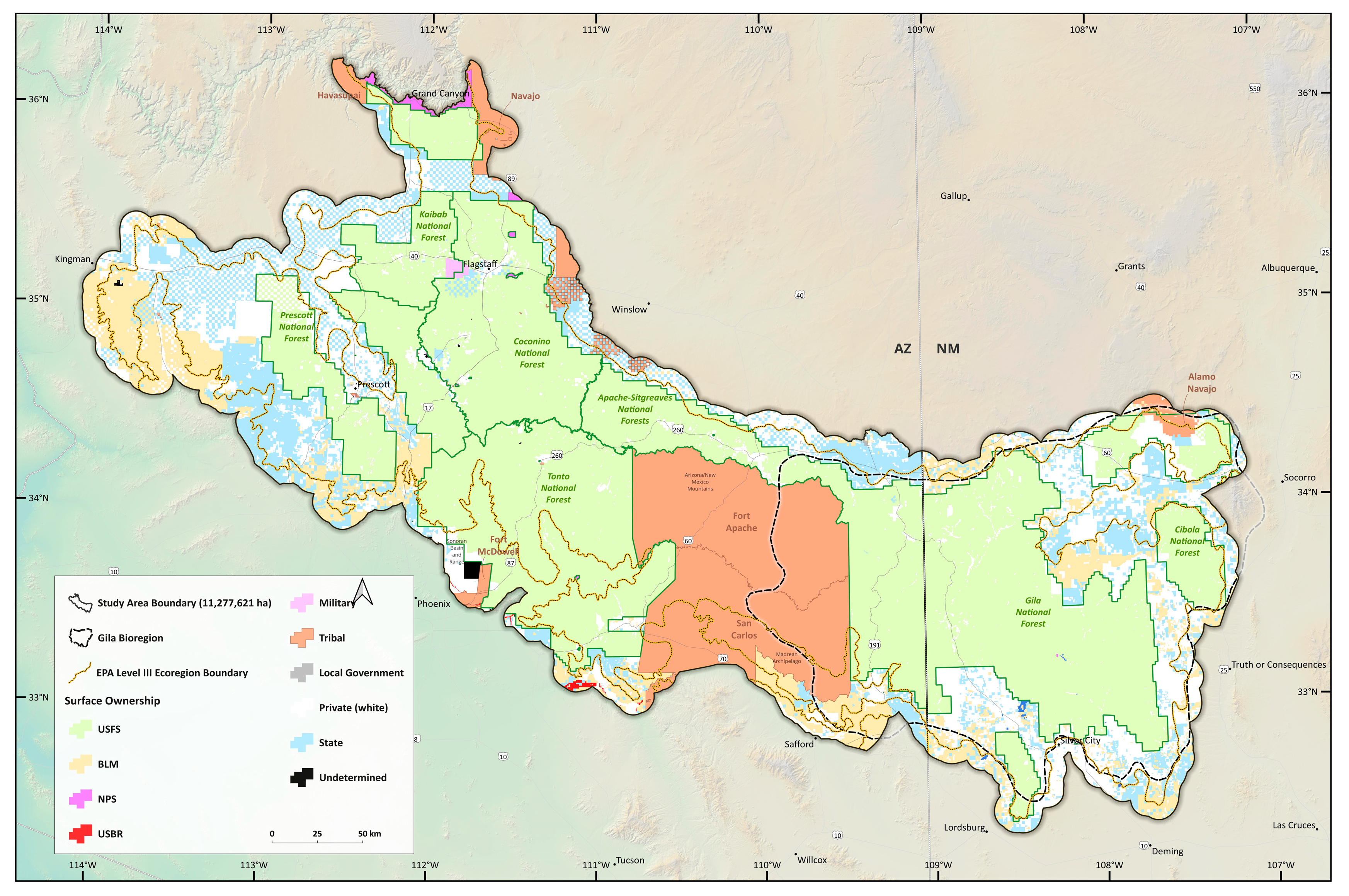
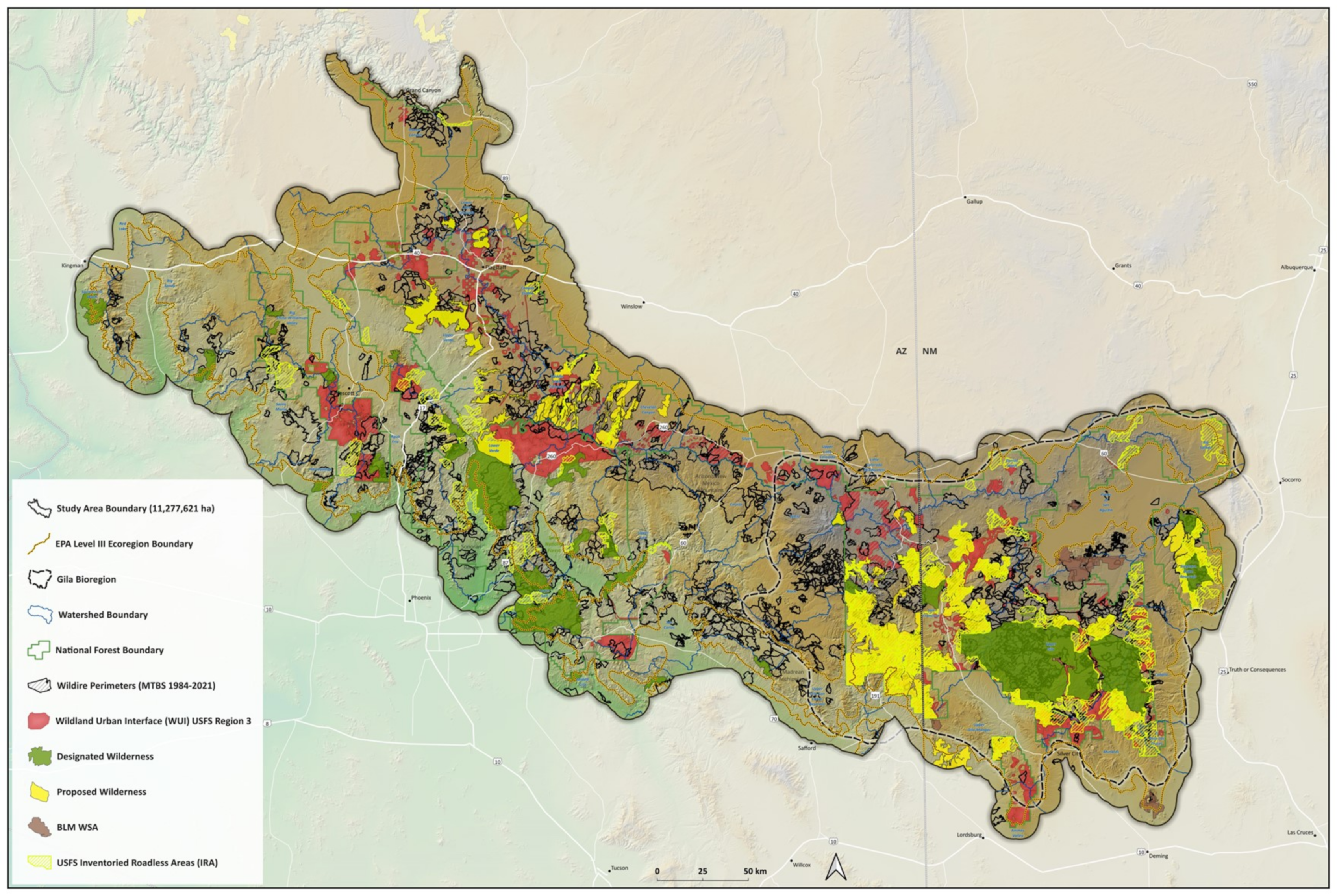
2. Study Area
3. Methods
3.1. Landowners and GAP Status
3.2. Existing Vegetation Types (2020 Update)
3.3. Mature and Old-Growth (MOG) Forests
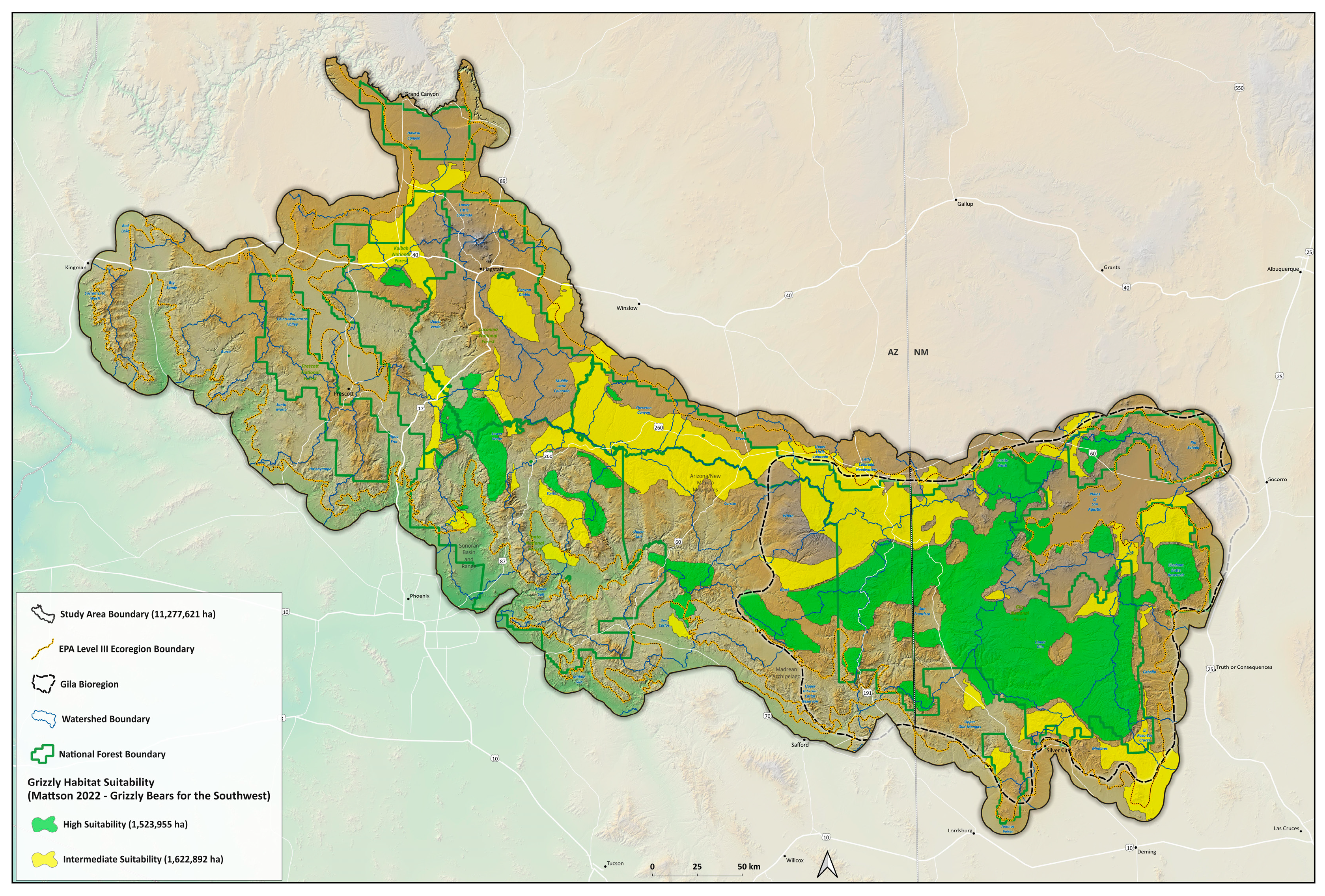
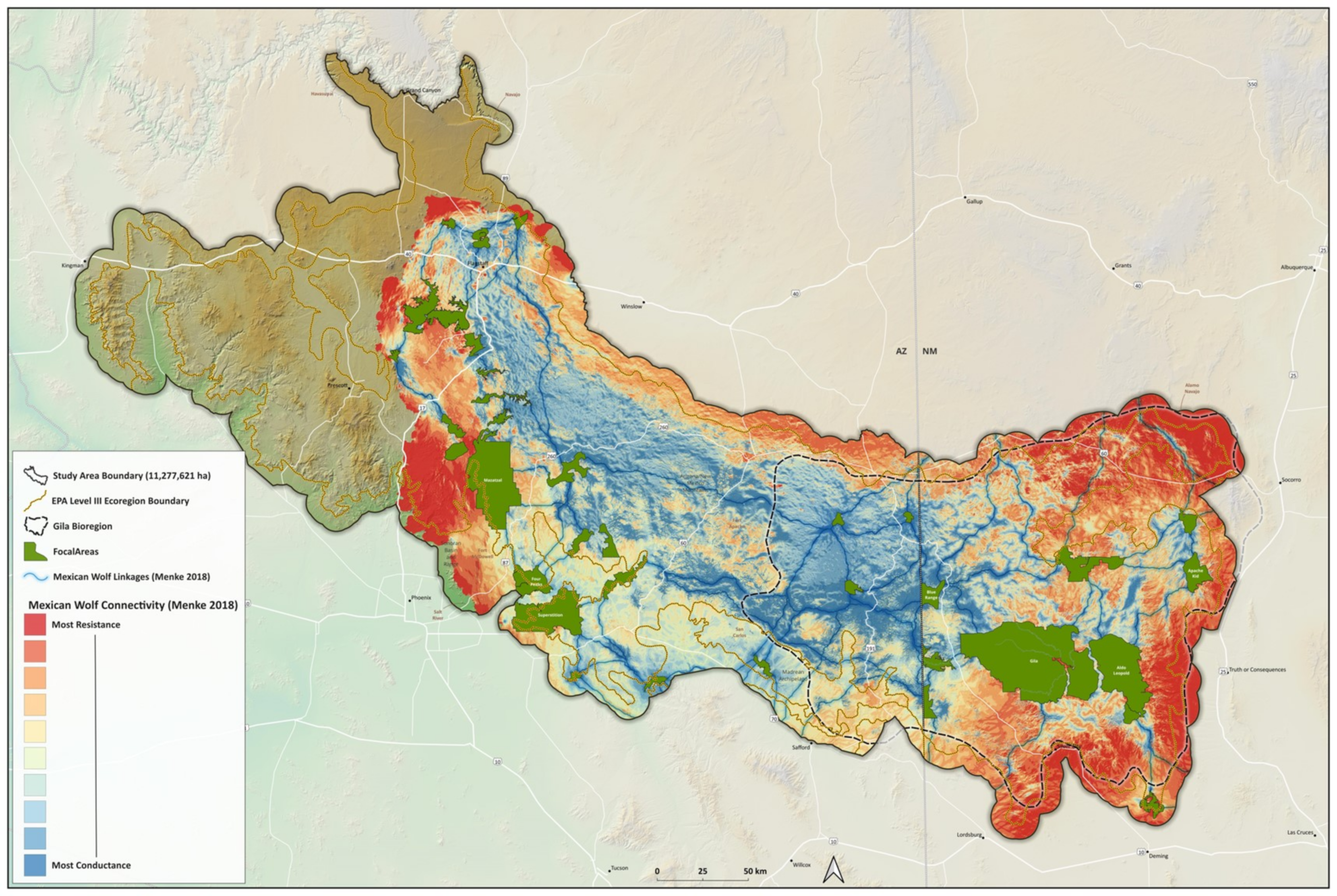
3.4. Mexican Wolf Connectivity and Grizzly Bear Potential Habitat
3.5. Wildland Urban Interface (WUI) and Wildfires
3.6. Downscaled Climate Projections
4. Results
4.1. Landownerships and Major Vegetation Groupings
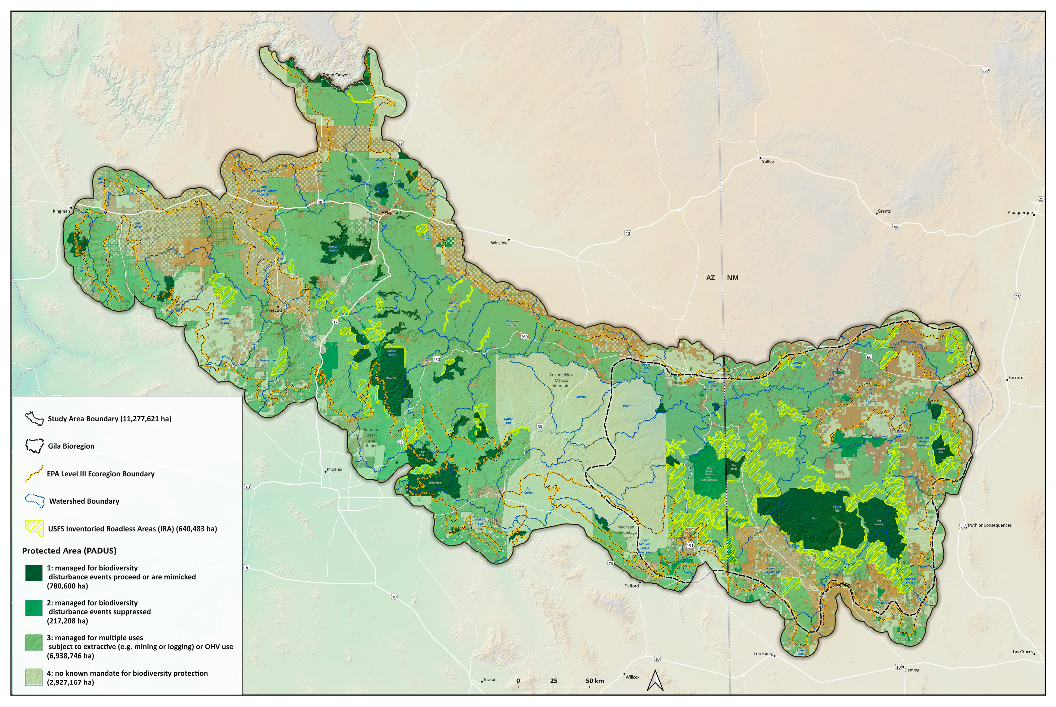
4.2. GAP Status of Vegetation Groups
4.3. Mature and Old-Growth (MOG) Forests
4.4. Potential Grizzly Bear Habitat and Mexican Wolf Connectivity
4.5. Wildland Urban Interface
4.6. Climate Change Impacts and Projections
5. Discussion
5.1. Biological Distinctiveness and At-Risk Types
5.2. Landownerships and GAP Status
5.3. Wildland Urban Interface and Wildfires
5.4. Climate Change and Other Risk Factors
5.5. Conservation and Management Implications
6. Conclusions
Supplementary Materials
Author Contributions
Funding
Data Availability Statement
Acknowledgments
Conflicts of Interest
References
- Fleischner, T.L.; Floyd, M.L.; Rack, J.; Hanna, D.; Blevins, K.; Christman, B.; Holycross, A.T. The Mogollon Highlands Ecoregion of the American Southwest: A Neglected Center of Ecological Diversity. Nat. Areas J. 2024, in press. [Google Scholar]
- Ricketts, T.H. Terrestrial Ecoregions of North America: A Conservation Assessment; Island Press: Washington, DC, USA, 1999. [Google Scholar]
- Coconino County Wildlife Connectivity Assessment: Detailed Linkages. San Francisco Peaks—Mogollon Rim Linkage Design. Arizona Game and Fish Department. Available online: https://azgfd-portal-wordpress-pantheon.s3.amazonaws.com/wp-content/uploads/archive/PeakstoRimLinkageDesign_FinalReport_22AUG2013.pdf (accessed on 22 August 2023).
- Miller, B.; Foreman, D.; Fink, M.; Shinneman, D.; Smith, J.; DeMarco, M.; Soule, M.; Howard, R. Southern Rockies Wildlands Network Vision: A Science-Based Approach to Rewilding the Southern Rockies. Available online: https://rewilding.org/wp-content/uploads/2021/09/S.-Rockies-WND.pdf (accessed on 22 August 2023).
- González-Saucedo, Z.Y.; González-Bernal, A.; Martínez-Meyer, E. Identifying Priority Areas for Landscape Connectivity for Three Large Carnivores in Northwestern Mexico and Southwestern United States. Landsc. Ecol. 2021, 36, 877–896. [Google Scholar] [CrossRef]
- DellaSala, D.A.; Mackey, B.; Norman, P.; Campbell, C.; Comer, P.J.; Kormos, C.F.; Keith, H.; Rogers, B. Mature and Old-Growth Forests Contribute to Large-Scale Conservation Targets in the Conterminous United States. Front. For. Glob. Chang. 2022, 5, 979528. [Google Scholar] [CrossRef]
- Archer, S.R.; Predick, K.I. Climate Change and Ecosystems of the Southwestern United States. Rangelands 2008, 30, 23–28. [Google Scholar] [CrossRef]
- Schoennagel, T.; Nelson, C.R.; Theobald, D.M.; Carnwath, G.C.; Chapman, T.B. Implementation of National Fire Plan Treatments near the Wildland-Urban Interface in the Western United States. Proc. Natl. Acad. Sci. USA 2009, 106, 10706–10711. [Google Scholar] [CrossRef] [PubMed]
- DellaSala, D.A.; Baker, B.C.; Hanson, C.T.; Ruediger, L.; Baker, W. Have Western USA Fire Suppression and Megafire Active Management Approaches Become a Contemporary Sisyphus? Biol. Conserv. 2022, 268, 109499. [Google Scholar] [CrossRef]
- US EPA. Level III and IV Ecoregions of the Continental United States. Available online: https://www.epa.gov/eco-research/level-iii-and-iv-ecoregions-continental-united-states (accessed on 22 August 2023).
- Bird, B.; Horning, J. The Greater Gila Bioregion: America’s First Wilderness. Available online: https://pdf.wildearthguardians.org/site/DocServer/gila-vision-report-03-09.pdf (accessed on 7 September 2023).
- Griffith, G.E.; Omernik, J.M.; Johnson, C.B.; Turner, D.S. Ecoregions of Arizona (Poster). Open-File Report. 2014. Available online: https://pubs.usgs.gov/of/2014/1141/pdf/ofr2014-1141_front.pdf (accessed on 7 September 2023).
- QGIS Development Team Open-Source Geospatial Foundation Project. Available online: http://qgis.osgeo.org (accessed on 23 August 2023).
- Jones, K.; Niknami, L.S.; Buto, S.G.; Decker, D. Federal Standards and Procedures for the National Watershed Boundary Dataset (WBD). In Collection and Delineation of Spatial Data; Chapter 3 of Section A; U.S. Department of the Interior: Washington, DC, USA, 2022. [Google Scholar] [CrossRef]
- U.S. Department of Interior Bureau of Land Management Geospatial Business Platform. Arizona Geospatial Data. Available online: https://gbp-blm-egis.hub.arcgis.com/pages/arizona (accessed on 7 September 2023).
- U.S. Department of Interior Bureau of Land Management Geospatial Business Platform. New Mexico Geospatial Data. Available online: https://gbp-blm-egis.hub.arcgis.com/pages/newmexico (accessed on 7 September 2023).
- Enterprise Data Warehouse. U.S. Forest Service. Available online: https://www.fs.usda.gov/about-agency/enterprise-data-warehouse (accessed on 7 September 2023).
- PAD-US Data Download|U.S. Geological Survey. Available online: https://www.usgs.gov/programs/gap-analysis-project/science/pad-us-data-download (accessed on 7 September 2023).
- National Conservation Easement Database|NCED. Available online: https://www.conservationeasement.us/ (accessed on 7 September 2023).
- Wilderness Connect. Available online: https://wilderness.net/visit-wilderness/maps.php (accessed on 7 September 2023).
- USDA. Forest Service FSGeodata Clearinghouse—Download National Datasets. Available online: https://data.fs.usda.gov/geodata/edw/datasets.php (accessed on 7 September 2023).
- OpenStreetMap. Available online: https://www.openstreetmap.org/#map=3/38.00/-86.26/ (accessed on 7 September 2023).
- Natural Earth. Available online: https://www.naturalearthdata.com/downloads/ (accessed on 7 September 2023).
- LANDFIRE Existing Vegetation Type|U.S. Department of Agriculture and U.S. Department of the Interior. Available online: https://www.landfire.gov/viewer/ (accessed on 27 September 2023).
- Mattson, D.J. Grizzly Bears for the Southwest: History and Prospects for Grizzly Bears in Arizona, New Mexico, and Colorado; Report GBRP-2022-1; Grizzly Bear Recovery Project: Livingston, MT, USA, 2022; pp. 1–105. [Google Scholar]
- Shah, V.B.; McRae, B.H. Circuitscape: A tool for landscape ecology. In Proceedings of the 7th Python in Science Conference (SciPy 2008), Pasadena, CA, USA, 19–24 August 2008; Varoquaux, G., Vaught, T., Millman, J., Eds.; 2008; pp. 62–66. Available online: https://circuitscape.org/pubs/Shah_McRae_Circuitscape_Python_Scipy08.pdf (accessed on 27 September 2023).
- McRae, B.H.; Kavanagh, D.M. Linkage Mapper Connectivity Analysis Software; The Nature Conservancy: Seattle, WA, USA, 2011; Available online: https://linkagemapper.org/ (accessed on 27 September 2023).
- U.S. Forest Service Southwestern Region GIS Data. USDA. Forest Service. Available online: https://www.fs.usda.gov/r3/gis/gisdata/r3_wui_all.zip (accessed on 7 September 2023).
- Monitoring Trends in Burn Severity (MTBS). Available online: https://www.mtbs.gov/direct-download (accessed on 5 September 2023).
- NOAA Climate Data Online (CDO)|National Climatic Data Center (NCDC). Available online: https://www.ncei.noaa.gov/cdo-web/ (accessed on 5 September 2023).
- Abatzoglou, J.T.; Brown, T.J. A comparison of statistical downscaling methods suited for wildfire applications. Int. J. Climatol. 2012, 32, 772–780. [Google Scholar] [CrossRef]
- Data Overview|Climate Toolbox. Available online: https://climatetoolbox.org/data (accessed on 8 September 2023).
- Bachelet, D.; Turner, D. (Eds.) Global Vegetation Dynamics: Concepts and Applications in the MC1 Model. In AGU Geophyiscal Monographs; Wiley: Hoboken, NJ, USA, 2015; Volume 214, 210p. [Google Scholar]
- Heinsch, F.A.; Andrews, P.L.; Kurth, L.L. Implications of using percentiles to define fire danger levels. In Proceedings of the 8th Symposium on Fire and Forest Meteorology, Kalispell, MT, USA, 13–15 October 2009; pp. 1–12. Available online: https://ams.confex.com/ams/pdfpapers/156081.pdf (accessed on 8 September 2023).
- Buck, R.; Ortega-Del Vecchyo, D.; Gehring, C.; Michelson, R.; Flores-Rentería, D.; Klein, B.; Whipple, A.V.; Flores-Rentería, L. Sequential Hybridization May Have Facilitated Ecological Transitions in the Southwestern Pinyon Pine Syngameon. New Phytol. 2022, 237, 1943–1945. [Google Scholar] [CrossRef]
- Downing, W.M.; Dunn, C.J.; Thompson, M.P.; Caggiano, M.D.; Short, K.C. Human Ignitions on Private Lands Drive USFS Cross-Boundary Wildfire Transmission and Community Impacts in the Western US. Sci. Rep. 2022, 12, 2624. [Google Scholar] [CrossRef]
- Schoennagel, T.; Balch, J.K.; Brenkert-Smith, H.; Dennison, P.E.; Harvey, B.J.; Krawchuk, M.A.; Mietkiewicz, N.; Morgan, P.; Moritz, M.A.; Rasker, R.; et al. Adapt to More Wildfire in Western North American Forests as Climate Changes. Proc. Natl. Acad. Sci. USA 2017, 114, 4582–4590. [Google Scholar] [CrossRef]
- Poulos, H.M.; Freiburger, M.R.; Barton, A.M.; Taylor, A.H. Mixed-severity wildfire as a driver of vegetation change in an Arizona Madrean Sky Island System, USA. Fire 2021, 4, 78. [Google Scholar] [CrossRef]
- Floyd, M.L.; Romme, W.H.; Hanna, D.D. Effects of Recent Wildfires in Piñon-Juniper Woodlands of Mesa Verde National Park, Colorado, USA. Nat. Areas J. 2021, 41, 28–38. [Google Scholar] [CrossRef]
- Guiterman, C.H.; Margolis, E.Q.; Allen, C.R.; Falk, D.A.; Swetnam, T.W. Long-Term Persistence and Fire Resilience of Oak Shrubfields in Dry Conifer Forests of Northern New Mexico. Ecosystems 2017, 21, 943–959. [Google Scholar] [CrossRef]
- Redmond, M.D.; Forcella, F.; Barger, N.N. Declines in Pinyon Pine Cone Production Associated with Regional Warming. Ecosphere 2012, 3, art120. [Google Scholar] [CrossRef]
- Huffman, D.W.; Floyd, M.L.; Hanna, D.P.; Crouse, J.E.; Fulé, P.Z.; Sánchez Meador, A.J.; Springer, J.D. Fire Regimes and Structural Changes in Oak-Pine Forests of the Mogollon Highlands Ecoregion: Implications for Ecological Restoration. For. Ecol. Manag. 2020, 465, 118087. [Google Scholar] [CrossRef]
- Huffman, D.W.; Zegler, T.J.; Fulé, P.Z. Fire History of a Mixed Conifer Forest on the Mogollon Rim, Northern Arizona, USA. Int. J. Wildland Fire 2015, 24, 680. [Google Scholar] [CrossRef]
- Williams, M.A.; Baker, W.L. High-Severity Fire Corroborated in Historical Dry Forests of the Western United States: Response to Fuléet Al. Glob. Ecol. Biogeogr. 2014, 23, 831–835. [Google Scholar] [CrossRef]
- Gila River Named America’s Most Endangered River of 2019. American Rivers. Available online: https://www.americanrivers.org/media-item/gila-river-named-americas-most-endangered-river-of-2019/ (accessed on 8 September 2023).
- Baker, W.L.; Hanson, C.T.; Williams, M.A.; DellaSala, D.A. Countering Omitted Evidence of Variable Historical Forests and Fire Regime in Western USA Dry Forests: The Low-Severity-Fire Model Rejected. Fire 2023, 6, 146. [Google Scholar] [CrossRef]
- 2021 Forest Health Conditions in Arizona and New Mexico. Available online: https://www.fs.usda.gov/detailfull/r3/forest-grasslandhealth/?cid=fseprd855188&width=full (accessed on 8 September 2023).
- Kannenberg, S.A.; Driscoll, A.W.; Malesky, D.; Anderegg, W.R.L. Rapid and Surprising Dieback of Utah Juniper in the Southwestern USA due to Acute Drought Stress. For. Ecol. Manag. 2021, 480, 118639. [Google Scholar] [CrossRef]
- Rodman, K.C.; Crouse, J.E.; Donager, J.J.; Huffman, D.W.; Sánchez Meador, A.J. Patterns and Drivers of Recent Land Cover Change on Two Trailing-Edge Forest Landscapes. For. Ecol. Manag. 2022, 521, 120449. [Google Scholar] [CrossRef]
- Millar, C.I.; Westfall, R.D.; Delany, D.L. Response of High-Elevation Limber Pine (Pinus flexilis) to Multisyear Droughts and 20th-Century Warming, Sierra Nevada, California, USA. Can. J. For. Res. 2007, 37, 2508–2520. [Google Scholar] [CrossRef]
- Fleischner, T.L. Ecological costs of livestock grazing in western North America. Conserv. Biol. 1994, 8, 629–644. [Google Scholar] [CrossRef]
- Cohen, J. The wildland-urban interface fire problem. Fremontia 2010, 38, 16–22. [Google Scholar]
- Baker, W.L.; Williams, M.A. Land Surveys Show Regional Variability of Historical Fire Regimes and Dry Forest Structure of the Western United States. Ecol. Appl. 2018, 28, 284–290. [Google Scholar] [CrossRef] [PubMed]
- Dinerstein, E.; Vynne, C.; Sala, E.; Joshi, A.R.; Fernando, S.; Lovejoy, T.E.; Mayorga, J.; Olson, D.; Asner, G.P.; Baillie, J.E.M.; et al. A Global Deal for Nature: Guiding Principles, Milestones, and Targets. Sci. Adv. 2019, 5, eaaw2869. [Google Scholar] [CrossRef]
- Beschta, R.L.; Donahue, D.L.; DellaSala, D.A.; Rhodes, J.J.; Karr, J.R.; O’Brien, M.H.; Fleischner, T.L.; Deacon Williams, C. Adapting to Climate Change on Western Public Lands: Addressing the Ecological Effects of Domestic, Wild, and Feral Ungulates. Environ. Manag. 2012, 51, 474–491. [Google Scholar] [CrossRef] [PubMed]
- Johnson, G.E.; van Riper, C., III. Effects of Reintroduced Beaver (Castor canadensis) on Riparian Bird Community Structure along the upper San Pedro River, Southeastern Arizona and Northern Sonora, Mexico; U.S. Geological Survey: Reston, VA, USA, 2014. Available online: https://pubs.usgs.gov/of/2014/1121/pdf/ofr2014-1121.pdf (accessed on 8 September 2023).
- Stevens, L.E.; Meretsky, V.J. Arizona-Sonora Desert Museum (Tucson, Ariz. Aridland Springs in North America: Ecology and Conservation); University of Arizona Press; The Arizona-Sonora Desert Museum: Tucson, AZ, USA, 2008. [Google Scholar]
- Balch, J.K.; Bradley, B.A.; Abatzoglou, J.T.; Nagy, R.C.; Fusco, E.J.; Mahood, A.L. Human-Started Wildfires Expand the Fire Niche across the United States. Proc. Natl. Acad. Sci. USA 2017, 114, 2946–2951. [Google Scholar] [CrossRef]


| Vegetation Group | HA (%) | GAP 1 HA (%) | GAP 2 HA (%) | GAP 3 HA (%) | GAP 4 HA (%) |
|---|---|---|---|---|---|
| Ponderosa Pine Forest | 1,736,331 (15.4%) | 135,043 (7.8%) | 27,842 (1.6%) | 1,311,517 (75.5%) | 261,929 (15.1%) |
| Piñon–Juniper Woodlands | 3,285,485 (29.1%) | 302,435 (9.2%) | 65,132 (2.0%) | 2,170,935 (66.1%) | 746,983 (22.7%) |
| Conifer–Oak Forest and Woodland | 389,220 (3.4%) | 53,871 (13.8%) | 9201 (2.4%) | 208,797 (53.6%) | 117,351 (30.2%) |
| Juniper Woodland and Savanna | 41,952 (0.4%) | 1141 (2.7%) | 943 (2.3%) | 25,671 (61.2%) | 14,197 (33.8%) |
| Spruce–Fir Forest and Woodlands | 49,996 (0.4%) | 8639 (17.3%) | 2399 (4.8%) | 19,812 (39.6%) | 19,147 (38.3%) |
| Douglas Fir–Ponderosa Pine–Lodgepole Pine Forest and Woodland | 62,099 (0.6%) | 13,488 (21.7) | 661 (1.1%) | 42,893 (69.1%) | 5056 (8.1%) |
| Aspen Forest Woodland and Parkland | 16,740 (0.2%) | 3840 (22.9%) | 866 (5.2%) | 8177 (48.9%) | 3856 (23.0%) |
| Limber Pine Woodland | 3846 (0.0%) | 1308 (34.0%) | 393 (10.2%) | 2098 (54.6%) | 47 (1.2%) |
| Western Riparian Woodland and Shrubland | 48,190 (0.4%) | 3494 (7.3%) | 1942 (4.0%) | 24,211 (50.2%) | 18,543 (38.5%) |
| Historical Trends 1 | Projections for 2070-99 2 | |
|---|---|---|
| 1970–2022 | Lower Emissions (RCP4.5) | Higher Emissions (RCP8.5) |
| Temp. +1.4 °C | Temp. +2 to +4 °C | Temp. +3 to +7 °C |
| Max. temp. +1.2 °C | Max. temp. +2 to +5 °C | Max. temp. +3 to +8 °C |
| Min. temp. +2.2 °C | Min. temp. +1 to +4 °C | Min. temp. +3 to +6 °C |
| +7 days/yr. above 32 °C | +35 days above 32 °C | +64 days above 32 °C |
| – | +15 days above 38 °C | +34 days above 38 °C |
| – | +11 days above 41 °C | +24 days above 41 °C |
| −24 nights < freezing | −14 to −47 nights < freezing | −28 to −68 nights < freezing |
| 16% less precipitation | Precipitation +20% to −11% | Precipitation +47% to −35% |
| Increasing drought 3 | +5 to +31% CWD 4 | +17 to +69% CWD 4 |
| 30–35% reduced snowfall 5 | 40–97% lower SWE 6 | 77–100% lower SWE 6 |
| Verde River flow −34–41% | – | – |
Disclaimer/Publisher’s Note: The statements, opinions and data contained in all publications are solely those of the individual author(s) and contributor(s) and not of MDPI and/or the editor(s). MDPI and/or the editor(s) disclaim responsibility for any injury to people or property resulting from any ideas, methods, instructions or products referred to in the content. |
© 2023 by the authors. Licensee MDPI, Basel, Switzerland. This article is an open access article distributed under the terms and conditions of the Creative Commons Attribution (CC BY) license (https://creativecommons.org/licenses/by/4.0/).
Share and Cite
DellaSala, D.A.; Kuchy, A.L.; Koopman, M.; Menke, K.; Fleischner, T.L.; Floyd, M.L. An Ecoregional Conservation Assessment for Forests and Woodlands of the Mogollon Highlands Ecoregion, Northcentral Arizona and Southwestern New Mexico, USA. Land 2023, 12, 2112. https://doi.org/10.3390/land12122112
DellaSala DA, Kuchy AL, Koopman M, Menke K, Fleischner TL, Floyd ML. An Ecoregional Conservation Assessment for Forests and Woodlands of the Mogollon Highlands Ecoregion, Northcentral Arizona and Southwestern New Mexico, USA. Land. 2023; 12(12):2112. https://doi.org/10.3390/land12122112
Chicago/Turabian StyleDellaSala, Dominick A., Andréa L. Kuchy, Marni Koopman, Kurt Menke, Thomas L. Fleischner, and M. Lisa Floyd. 2023. "An Ecoregional Conservation Assessment for Forests and Woodlands of the Mogollon Highlands Ecoregion, Northcentral Arizona and Southwestern New Mexico, USA" Land 12, no. 12: 2112. https://doi.org/10.3390/land12122112
APA StyleDellaSala, D. A., Kuchy, A. L., Koopman, M., Menke, K., Fleischner, T. L., & Floyd, M. L. (2023). An Ecoregional Conservation Assessment for Forests and Woodlands of the Mogollon Highlands Ecoregion, Northcentral Arizona and Southwestern New Mexico, USA. Land, 12(12), 2112. https://doi.org/10.3390/land12122112