1. Introduction
The Ciutadella of Roses is one of the most relevant monuments of the Mediterranean coast on the Iberian Peninsula. It is an area with many settlements from different periods that make the Ciutadella an exceptional palimpsest (
Figure 1). The first settlement documented in this place corresponded to a Greek city, Rhode. According to archaeological data, Rhode was founded in the fourth century BC [
1] (or perhaps earlier if written literary sources are considered (Strabo, III, 2, 10) that mention its foundation before the first ancient Olympic Games). It is known that this settlement expanded very actively during the third century BC, a time from which various workshops for ceramic manufacture have been documented [
1,
2]. This complex was destroyed at the start of the second century BC by the Roman army of the mid-Republic (Livy, XXXIV, 8, 4). From that point up until to the fifth century, the place was occupied by a
uicus, of which a fish salting factory is known [
3]. After the fall of the Roman Empire, the place was occupied by a Visigoth settlement, about which very little is known [
4,
5]. After a badly documented period, in the tenth century a Benedictine monastery was founded, dedicated to Santa Maria [
6]. Around it, a town began to develop [
7], which survived up to the seventeenth century when, in the context of the Reapers’ War, it was abandoned. Previously, in the mid-sixteenth century, the construction of a Renaissance fortification had begun, which had surrounded the mediaeval town [
8]. This military establishment was completely abandoned at the start of the nineteenth century, when the last garrison left the military stronghold. From that time, the site underwent a slow degradation until, at the end of the twentieth century, the monumental complex was purchased by Roses Town Council and made into a cultural space [
9].
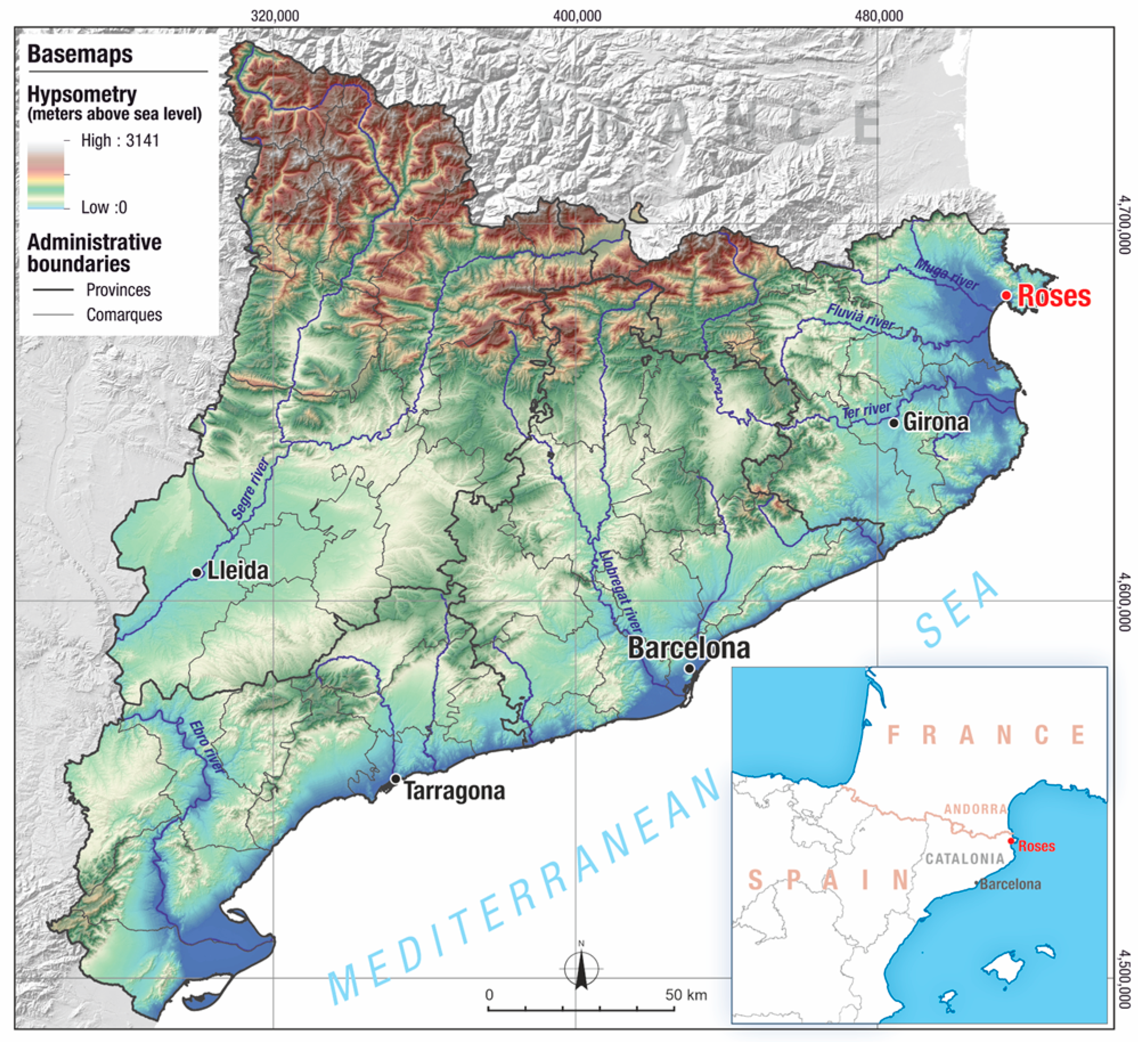
This succession of establishments was united by a common element: the sea. Their location right on the coast and on the north side of a gulf, known as the Gulf of Roses, in the northeast of the Iberian Peninsula, is considered a key factor to explain why they were founded and why this place was chosen for them (
Figure 2).
The Ciutadella of Roses occupies the central part of the coastal plain that unfolds at the foot of the mountainous arc formed by the Serrat de Can Berta and the Serra de Rodes (468 m at Puigsaquera peak) mountain ranges. This sector is drained from east to west by three main watercourses: the Riera de Ginjolers, Rec Fondo and the Riera de la Trencada. The last two creeks currently delimit the site of the citadel to the east and the west.
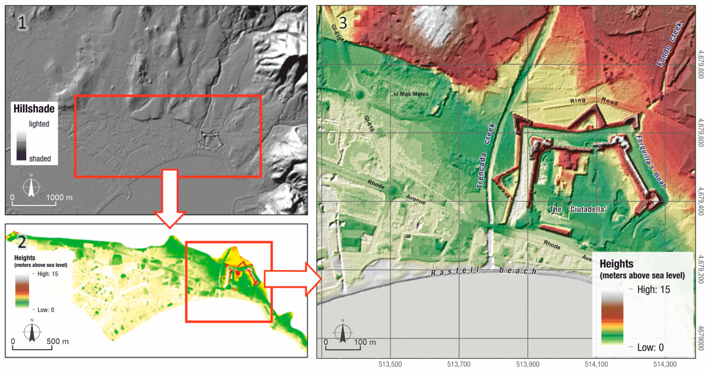
The mountainside has quite gentle slopes, which become almost flat towards the sea. In this sector, the most characteristic geomorphological feature is constituted by the presence of a terrace or topographic high that extends from east to west and separates the alluvial deposits of the early Quaternary period (Pleistocene) from the marsh deposits of the coastal Holocene plain. This terrace, which has been degraded to varying degrees by the anthropisation of the landscape, can be identified easily in the topographic map of Roses by the Cartographic and Geological Institute of Catalonia (ICGC) at a scale of 1/5000 (Sheet 313-84) and in the digital elevation model (DEM) generated using LIDAR data by the ICGC (
Figure 3). The outline of this terrace is particularly noticeable to the northwest of the citadel, on the right bank of the Riera de la Trencada, specifically in the area where the urban development of Mas Mates is located. The relief that comprises this morphological terrace rises to heights of between 7 and 10 masl, and dominate the marsh plain, which is at a height close to 2 masl. Within the current Ciutadella site, Pleistocene (early Quaternary) deposits can also be identified, which make up the small elevation of the Hill of Santa Maria (where the first occupation of this territory has been identified).
The next figure,
Figure 4, shows the detailed slope map established from the DEM. The most depressed areas topographically can be observed at different work scales. In accordance with geological and sedimentological knowledge of the area [
10,
11,
12,
13,
14] these correspond with areas formed of marsh sediments and the beach that would have been deposited during the recent Holocene and would have been under sea level in periods that are not so far in the past [
15,
16,
17]. From then to now, the shoreline would have advanced to its current position. In this respect, the most topographically depressed areas are those of the greatest interest for the geoarchaeological research undertaken in this study.
But what is known about this coast? Was it identical to the current one? In the past, did it have different morphological characteristics? There is a consensus in the research undertaken to date that the coastal landscape has changed over time and that in the past it was not identical to now. In essence, the seafront is considered to have had a very similar pattern to the current one, but was simply situated a few metres further inland, and over time it gradually advanced to where it is today [
18,
19]. The main point of conflict between the studies carried out to date is focused on a water channel, called Rec Fondo, whose course causes controversy. To summarise the proposals made up to now, it could be said that there are two main interpretations. One considers this creek never to have really existed or at least to have passed further to the east than the eastern boundary of the modern fortress [
20]. The other interpretation is that the Rec Fondo existed and its path ran right through the middle of the Renaissance fortress [
19,
21]. Publications that have addressed this issue essentially used two sources of information. The first is the relatively abundant military cartography. Associated with the large Renaissance fortification, in the modern era a large collection of maps was drawn up that, to varying degrees of accuracy, reproduced the environment in which the fortress was situated and the main river courses. The other main source of information is that supplied by archaeological excavations. As these have taken place, they have provided information that has enabled the various sites mentioned above to be situated and, indirectly, the shoreline to be outlined. Complementing these two main sources of information, the relatively abundant written documentation has been used in relation to the aforementioned main questions: the shoreline and the Rec Fondo.
Despite this abundant literature, a specifically geological study, with clear objectives that respond to the aforementioned questions and with the main aim of the resolution of the many doubts generated by the studies published to date, was lacking. For this reason, Roses Town Council commissioned an initial study from the company Geoservei in 2016. After the first study, others were carried out up to the year 2022, when the last surveys were undertaken.
The aim of the research carried out in this project was to define the geomorphological evolution of the northern coast of the Bay of Roses, in the surroundings of the citadel, from the ancient period, which coincided with the Greek occupation (fifth to third century BC) and subsequently the Roman occupation (second century BC to fifth century AD), until the start of the sixteenth century, which is when the construction work on the fortress began.
The study of archaeological characteristics complemented with geomorphological data and data on the management of the coastal space of ancient settlements, such as the Greek, Phoenician, Punic or Roman and later settlements, situated in areas close to the sea, are of great interest to understand the capacity for synergy of social and economic dynamics in the face of natural dynamics that are considered adverse. Such natural dynamics include the expansion of deltaic plains, the silting up of ports or global warming and rising sea levels, all of which are forecast in the coming decades according to the Intergovernmental Panel on Climate Change [
22]. These settlements constitute a temporal record of the model of occupation, local sea level, management of resources and socioeconomic structure. In almost all of them, the port constitutes a centre that is fundamental to ensuring sustainable development. For this reason, sites such as Roses, which have a long history of occupation, are studied and documented [
23]. This study presents the results of a geoarchaeological study carried out in the surroundings of the archaeological site of the Ciutadella of Roses to configure the transition between land and sea and the existence of a protected area at which to anchor.
To achieve the objectives of this geoarchaeological research, the studies that were carried out were organised into the following methodological blocks, which are described in detail in the methodology section. Palaeographic and historical records were gathered and reviewed, and a geomorphological study was carried out in the surroundings of the Ciutadella of Roses. In addition, sedimentary and palaeontological prospecting was undertaken, with the logging and sampling of various boreholes. Finally, a preliminary study of palaeoenvironmental indicators was carried out in the laboratory, and samples were selected for radiocarbon dating, and petrographic and mineralogical analyses of source areas of the Riera de la Trencada and the Rec Fondo watercourses were undertaken.
Study Area
The historical cartography that was consulted includes a set of representations of the surroundings of the Ciutadella de Roses from the mid-seventeenth century to the current time. This sequence can be used to compare the reliability of the representations and extract the basic characteristics of the morphological evolution over the last 400 years.
The studied littoral area is located at the east border of the Empordà basin, at the southern foothills of the Pyrenees, NE Iberian Peninsula. The coast forms the 18 km large Roses bay between the Cap de Creus promontory at the north and the Montgri Massif at the south. This wave-dominated coast shows a great variety of environments between the coastal plain and the foreshore, such as fresh water and brackish lagoons, meandering fluvial channels, beach barrier, dunes and inlets, which suggests a highly metastable landscape in the face of climate and sea level changes, as well in the face of human management.
The Roses bay receives the discharge of three rivers, Muga, Fluvià and Ter, between the harbours of Rhodas (present day Roses) and Emporion (present day Empúries), two Greek Massaliote trading centres of the Lion Gulf. In addition, sand nourishment from the Lion Gulf has been attested through remote sensing images and the presence of fossil dune outcrops at the Cap de Creus hills.
The present day coastal landscape results from significant management during the last 2500 years, from the introduction of the vineyard by the Greeks to the tourist expansion during the 1960s [
24]. It is characterized by relict forms of shallow brackish and freshwater marshes that are occasionally partly submerged during heavy rains or high tide during Levant storms [
15]. Research projects focused on Roses bay landscape evolution based on drill-coring analyses were conducted by Rambaud [
21,
25] and Bony [
26], and more recently by Ejarque [
24] and several authors such as Montarner, Julià and Castanyer for the northern lagoons [
27,
28,
29,
30] and for the southern zone of the bay [
31]. All these authors agree about the profound landscape change and the difficulty of interpreting the classical text describing the geography of this coast, and they provide similar late Holocene evolution models of a coastal lagoons [
32,
33]. Consequently, any picture provided of Greek or Roman harbours and hinterland trading connectivity remains partial.
The study region is characterized by a maritime Mediterranean climate. The zone is exposed to the Tramontane, NNW dry and fresh winds mainly blowing during the winter months and often reaching speeds of >100 km/h. The zone is also exposed to occasional easterly gale-force Levantine winds, which can cause storm surges and coastal flooding during autumn months. The storms can cause high-energy waves up to >1 m high in this typically Mediterranean microtidal area, where the average tidal range is only 0.15 m. The combination of wind patterns and northerly sea currents from the Gulf of Lyon exert a strong influence on coastal dynamics [
34].
2. Materials and Methods
Based on the geomorphological elements of the area and considering the objectives that were set, the need to carry out geoarchaeological prospecting was determined. This consisted mainly of making boreholes and various stages of exploration and characterisation, which were defined and detailed in successive stages depending on the results obtained in the previous explorations and characterisations. Consequently, three field surveys were undertaken, and a total of 8 boreholes were made. The positions and codes of the boreholes are shown in the
Figure 5.
Table 1, below, indicates the coordinates of the position of the boreholes and the prospection depth.
The locations of the three boreholes corresponding to the first field survey (S1, S2 and S3) reflect the need to verify whether the shoreline was in positions further inland in the past. These were three exploratory boreholes undertaken in three strategic positions: S1 in a central point of the front of the sea wall and S2 and S3 at the ends of this wall on both sides.
The three boreholes in the second field survey (S4, S5 and S6) were designed to determine whether the shoreline in the ancient period reached inside the esplanade of the citadel’s fortress, and, if so, up to which point (S4), and whether Rec Fondo continued through the middle of the current esplanade of the fortress, and at what point it linked with (flowed into) the shoreline (S4). In addition, an attempt was made to establish whether the marshy plain of the western sector connected with the aforementioned pond, or whether it was, in contrast, open sea (S5). Finally, the aim was to determine whether a pond existed as described/mapped in some of the historical maps that located it to the northwest of the Ciutadella (S6).
Finally, the two boreholes in the third field survey (S7 and S8) were designed to determine with greater accuracy up to what point the shoreline reached within the esplanade of the citadel’s fortress in the ancient period, and to confirm the existence of clearly fluvial sediments that would indicate the path of a creek or torrent in the middle of the fortress’s current esplanade. In other words, the aim was to confirm the presence of Rec Fondo and in which periods it was present.
When the boreholes were created in the three field surveys, in addition to the tasks of coordination and direction of the boring, each one was monitored and logged as the boring works advanced, with a detailed description of the samples obtained. The samples were described in situ, with observations of sedimentological, faunal and plant remains being aspects that were considered of interest for the objectives of geomorphological reconstruction.
The samples were also studied at laboratory scale to analyse various aspects (mineralogical, faunal, plant remains, presence of ceramics, among others) that are necessary for correct interpretation of the palaeoenvironmental reconstructions of the zone. This detailed analysis enabled the identification of singularities of the sedimentary environments in the study zone, and therefore their potential correlation with certain palaeolandscapes, which generally correspond with the interspersion of fluvial and coastal environments of a superficial nature [
11,
15,
16,
17,
35,
36,
37,
38].
In the framework of the project, 12 samples were sent to an approved laboratory (Beta Analytic Radiocarbon Dating Laboratory) for radiocarbon dating (14C).
Table 2 indicates the stratigraphic position of the 12 selected samples. The radiocarbon age results for the marine samples were corrected for the reservoir effect by subtracting 353 years [
39], while the radiocarbon age of the terrestrial samples was treated according to the protocol of Stuiver et al. [
40], Reimer et al. [
41,
42] and Bronk [
43].
In addition, the chronological frame or model (
Figure 6) was established on the basis of 12 radiocarbon dating tests of organic samples, correlation of the stratigraphic position of the sample (in absolute height) and the age obtained.
The graphic representation of the stratigraphic position of the sample (in absolute height) and the age obtained in each of the 12 radiocarbon dating tests together revealed the position of the samples in relation to sea level (current zero height) and enabled observation of the slope of the trendlines. These indicate the sedimentation rate for a certain period at a specific geographic point. Thus, the trendlines observed in boreholes S1 to S5 show low sedimentation rates, which are consistent with marine or coastal transition environments (marshes), while the trendlines observed in boreholes S7 and S8 show higher sedimentation rates that are consistent with fluvial environments (prograding) and their areas of influence.
This model, together with the presence of ceramic fragments in sediments from the boreholes and contextual and concrete information obtained from historical cartography, historical references and archaeological data from preceding studies by various authors enabled us to define the lithostratigraphic correlations and establish isochrones.
3. Results
The analysis of the historical cartography, linked with the current geological works, show a complex beach, with a barrier beach preventing the direct outflow of the Riera de la Trencada to the sea. This cartographic representation also shows some steps that form isolated bodies of the barrier beach. The barrier beach ends towards the west, in the direction of the current Santa Margarida, which must have been where the waters of the Riera de la Trencada and those of the sea flowed together. The morphology of the barrier beach is compatible with the process of the reflection of waves coming from the first quadrant and from the east. This would have generated a longshore drift and transport of sand towards the west.
A second morphological element represented in the map of the siege is the marsh that, indicated as “Marecage” in the drawing by Le Pautre of 1693, occupies the space from the beach to where the relief begins. The author seems to indicate this transition between the marsh and the relief with a broken line. This change in relief corresponds to the geomorphological terrace (topographic high or geomorphological low escarpment) coincides with the boundary between the Holocene plain and older relief, mainly from the Pleistocene period.
Finally, in the representations of the citadel in the document by Le Pautre (1659), a pond can be seen at the foot of the slope of the bastion of Sant Jordi. This pond seemed to be situated on the bed of the Riera de la Trencada, linked with the marsh plain.
Subsequent maps maintain this image of the citadel surrounded to the west by the marshes that link with La Rubina at Santa Margarida. In this respect, the set of old maps of the surroundings of the citadel have enabled an interpretation of the existence of barrier beaches, marshes and depressed and protected areas. These elements provide information on the coastal dynamics of the area and facilitate the interpretation of possible scenarios for older periods.
Another interesting element that reflects some of the maps that were consulted is the existence of one or two river courses to the north of the citadel that are attributed to the Rec Fondo (situated further to the east) and the Riera de la Trencada (situated further to the west) and the continuity of these two courses to the sea or the capture/connection between them.
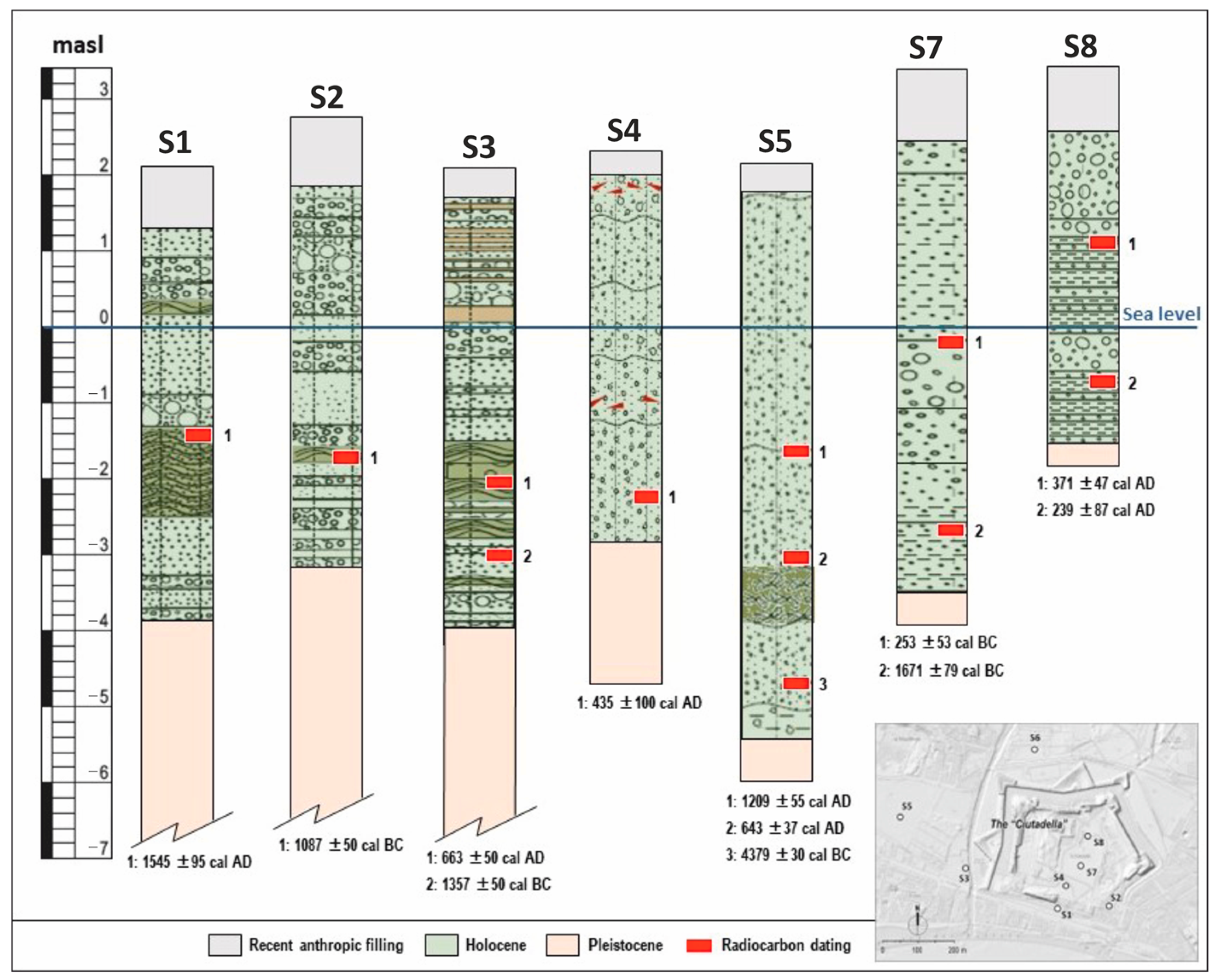
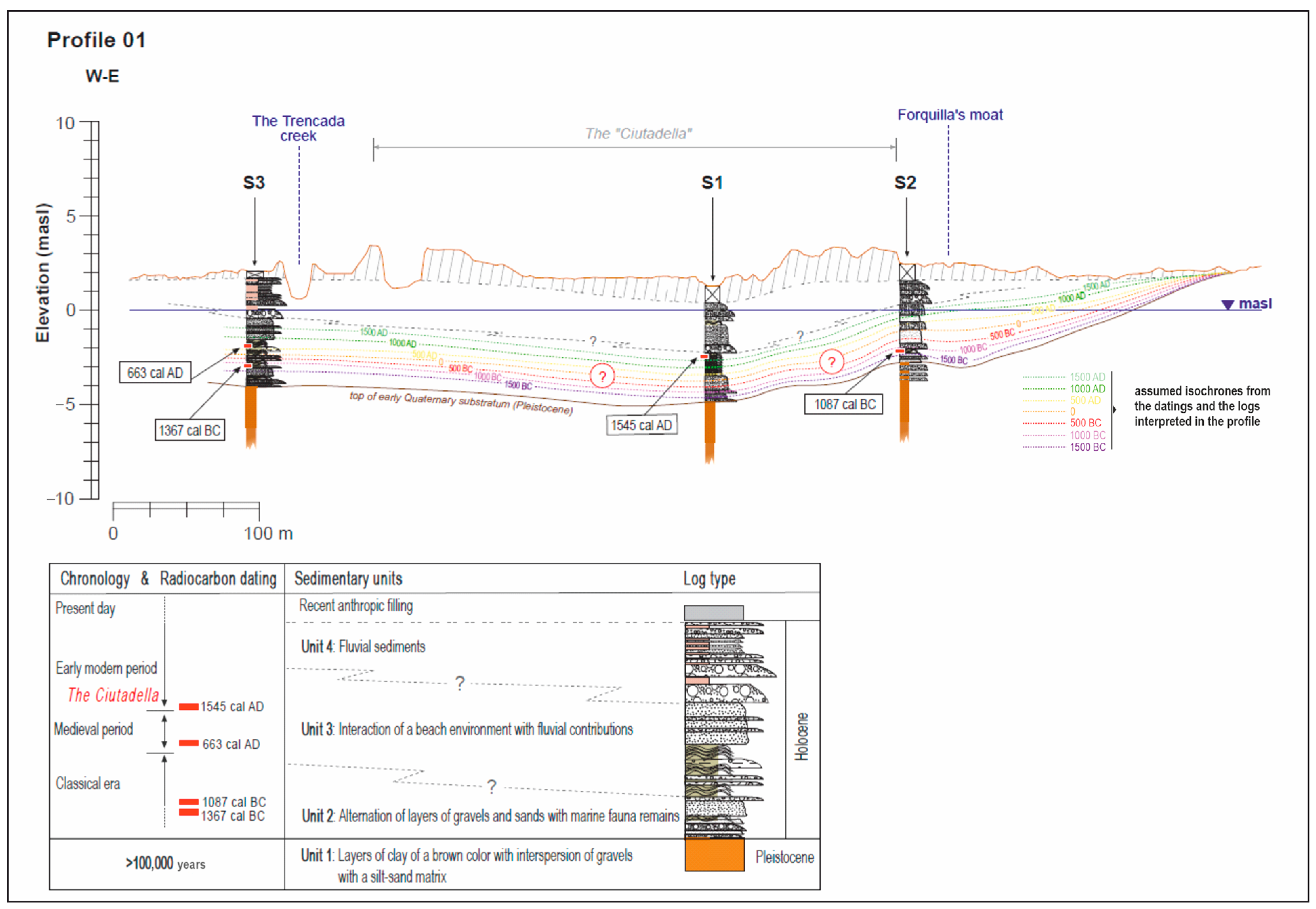
From the interpretation and correlation of the set of boreholes and the some profiles, up to four clear stratigraphic and chronological levels could be differentiated (
Figure 7 and
Figure 8). These are described below, from base to upper boundary.
▪ Unit 1: Layers of clay of a brown colour with interspersion of gravel with a silt–sand matrix, also of a brown colour, which is interpreted as the upper part (upper boundary) of the early Quaternary substratum that corresponds to the Pleistocene, with an age of >100,000 years. This base level is found from 5 to 6 m of depth, and constitutes an erosional unconformity that represents a lapsus of time corresponding to the difference in age of the Pleistocene materials and the much more recent age of the deposits on top of them.
▪ Unit 2: Alternation of layers of gravels and sands with layers of silts with the presence of plant fibres, woody remains and marine fauna remains deposited with unconformity on the previous unit (Pleistocene substratum). These deposits are interpreted as marine sediments with interspersion of fluvial contributions. This layer is always below sea level, at between 3 and 6 m of depth. The age attributed to it corresponds to the recent Holocene. According to the radiocarbon dating, these are sediments deposited during the ancient period and the mediaeval period. The base of this layer could be older than the dating results of this study. In borehole S5, this layer is represented by the presence of quite a strong layer formed from the accumulation of remains of Posidonia.
▪ Unit 3: Layers of sands and gravel with plant remains that suggest the interaction of a beach environment with fluvial contributions. These would be contributions of fluvial materials deposited on the shoreline that would have been reworked by the waves and longshore drift to form sand bars that would create beach barriers that would temporarily block the outflow of the creeks into the sea. The attributed age corresponds with the subrecent Holocene. According to the radiocarbon dating, these sediments were deposited during the modern period, from 1500. This chronology is consistent with the old cartography from this period. In borehole S6, only layers of sands and river gravel were found. No marsh layers were identified that could be interpreted as remains of the existence of a lagoon or inland pond, which some old maps situated in the northwest of the citadel, at the foot of the relief of the upper platform known as Mas Mates.
▪ Unit 4: Layers of gravel and sands with abundant remains of ceramics, plant remains (particularly woody material) and a considerable amount of charcoal that was interpreted as fluvial sediments. These materials were detected clearly in boreholes S6 and S8.
The sedimentary sequences described from the integration and correlation of the soundings carried out in this project make it possible to describe and interpret the existence of a sedimentary environment typical of the transitional Mediterranean coastline, in which a gradation of fluvial sediments over marine sediments can be observed, with the formation of coastal sandbars and areas of beach that have been gradually filled in by fluvial contributions, changing from being initially lagoon environments open to the sea to environments of a marshy and more restricted nature, before finally becoming completely regraded and forming the current relief.
4. Discussion
The integration of data from the digital elevation model (LIDAR), the geomorphological analysis, and the lithostratigraphic and chronological correlations based on the 8 geological boreholes and 12 radiocarbon datings, along with the historical data and archaeological remains found in the surroundings of the citadel, enabled a hypothesis to be established on the existing palaeolandscape around the site.
Figure 9,
Figure 10,
Figure 11,
Figure 12,
Figure 13 and
Figure 14 show the evolution of the palaeolandscape around the citadel (represented by the variation/displacement in the shoreline from more internal positions (inland) to the current position in successive time windows between the ancient period, which coincided with the Greek occupation (fifth to third centuries BC) and the subsequent Roman occupation (second century BC to fifth century AD), up to the start of the sixteenth century (modern period), when the construction work began on the fortress of the Ciutadella.
To interpret the palaeolandscape around the Ciutadella of Roses, particularly with regards to the position of the shoreline and the depth of the seabed, the current sea level was taken as a reference. It was considered that potential variations in sea level from the ancient period until today have not been significant, given that the eustatic rise in sea level recorded geologically indicates that the sea level could be considered almost stable.
The age of the upper boundary of the packet of beach sand with remains of Posidonia and marine fauna enable borehole S1 to be situated on a beach of little depth with only a 1.4 m water column or depth, from the start of the sixteenth century (Borehole S1). Therefore, in the classical period, the water column of this area would have been greater (in the order of 3.2 m, coinciding with the change in era). This indicates that the shoreline would have been in a part of the citadel that was further inland (boreholes S4, S7 and S8). The palaeoenvironmental characterisation and the dating results obtained in boreholes S2, S3 and S5 confirm the position of the shoreline further inland than in the modern period (1500 AD) and obviously further inland than at the current time.
In this respect, coinciding with the change in era in borehole S2 (to the east of the citadel) a water column of only 0.7 m was identified, corresponding to a beach environment, while in boreholes S3 and S5 (to the west of the citadel) the water column would be 2.5 m and 3.5 m, respectively. This reveals the existence in this sector of a marine abrasion platform that would have extended to the foot of the geomorphological terrace, where the urban development of Mas Mates is currently located. The thickness of the remains of Posidonia found in borehole S5 suggest that the marine abrasion platform recognised in this sector was probably restricted by beach barriers made of “spit” type sand bars that would have facilitated its silting up and that would rapidly evolve into a marsh plain, as reflected in most of the historical cartography from the seventeenth century. Even today relict areas can be observed.
In boreholes S1 (on the shoreline of the citadel) and S4, S7 and S8 (within the fortress), fluvial sediments have been recognised. Given the alignment of these boreholes with the path of Rec Fondo, the origin of the fluvial sediments could be attributed to this creek. However, due to proximity, these sediments could also have come from the Riera de la Trencada or longshore drift (which dominated this sector of the Bay of Roses) or other watercourses situated further to the east, such as the Riera de Ginjolers.
To resolve this last aspect, a mineralogical and petrographic study of materials present at the head and in the lower reach of the three main watercourses in the sector (La Trencada, Rec Fondo and Ginjolers) was undertaken to try to determine the potential origin of the fluvial sediments. No conclusive results were obtained.
The palaeolandscape that is interpreted is dominated, with orographic diversity in a small space, by the presence of the courses of various creeks that cross the plain. Small hills (such as that of Santa Maria) stand out, rising above the marshy plain. This coastal environment has been shaped and dominated by fluvial dynamics with their torrential contributions, and by coastal dynamics that would have redistributed the fluvial deposits along the coastline due to the effect of waves, longshore drift and, occasionally, powerful storms from the east. These factors formed the sand bars of the beach barriers. The superimposition of dynamics is clear. In 5 out of the 6 boreholes carried out on the shoreline, beds of gravel and coarse sands alternate with the fine sands of the beach. Considering the lack of a more comprehensive survey of the area in the west and the north, the most plausible scenario is that, surrounding this Pleistocene relief, the marshy plain that is represented in the digital elevation model and the cartography from the seventeenth century could have occupied a large area in the direction of Santa Margarida. Consequently, the centre of Santa Maria de Roses could have been a small peninsula or geographic cape.
Figure 15 shows a potential interpretation of the palaeolandscape, where the current shoreline is defined as well as a potential shoreline corresponding to the seventeenth century and another corresponding to the sixteenth century (which coincides with the period in which the citadel was built), and two previous shorelines corresponding to the ancient period (one of which coincides with the change in era and the other with the third century BC).
In this interpretation of the palaeolandscape around the citadel, the existence of a pond between the bastion of Sant Jordi and the relief of Mas Mates is excluded (represented in the cartography of the citadel drawn up by Le Pautre, 1659). This is because the lithostratigraphic record of borehole S6 does not reveal any evidence of marsh sedimentation.
5. Conclusions
Based on the studies carried out and the analysis and interpretation of the results obtained, it was possible to establish a hypothesis of the palaeolandscape that existed from the modern period (from the seventeenth century) until now (
Figure 16) and (although less precisely) from the ancient period. In this respect, the main conclusions of the study are summarised below.
The shoreline would have moved from the position it occupied in the ancient period to the current position through prograding depositional advance (contribution of materials that are deposited on the shoreline) rather than a drop in sea level. In fact, none of the data that were obtained and analysed enable the confirmation of the existence of an “absolute” negative oscillation in the sea level. The hypothesis that is maintained in this study considers that the sea level would have remained almost constant throughout the period of time studied up to now.
In the ancient period (
Figure 17), the shoreline had a profile that was considerably more irregular than in the current time (with more inflows and outflows). This coincided with the formation of erosive furrows corresponding to the described axes of drainage and the existence of small topographic elevations, such as the hill of Santa Maria de Roses and the hill of the Escorxador. The shoreline could probably enter inland to flood part of the western sector up to the foot of the geomorphological terrace of Mas Mates (forming a real marine abrasion platform) and part of the central esplanade of the fortress. In this context, the hill of Santa Maria would be configured as a small peninsula or geographic cape, practically surrounded by the sea.
In the ancient period, it is highly likely that the Riera de la Trencada and Rec Fondo discharged further inland than at the current time and were the main watercourses, of a seasonal nature, that provided sediment.
The marine abrasion platform recognised in the western sector would probably have been restricted well into the mediaeval period by barrier beaches formed by “spit” sand bars that would have facilitated its silting up by river sediment, mainly from the Riera de la Trencada. This area would evolve rapidly into a marshy plain, as reflected in most of the historical cartography from the seventeenth century onwards, and that today can be seen in some relict areas.
In the modern period (
Figure 18), the shoreline would have moved from the land towards the sea dozens or hundreds of metres (depending on the reference position) compared to the ancient period. In this respect, at the same time as the construction of the citadel (sixteenth century) it can be confirmed that the shoreline reached up to the sea wall.
Based on the available cartographic data, it is likely that Rec Fondo would have been diverted initially towards the Riera de la Trencada and, subsequently, towards the east with the construction of the Rec d’en Forquilla.
Finally, the proposed hypothesis of the existence of a pond between the bastion of Sant Jordi de la Ciutadella and the terrace or topographic high of Mas Mates could not be confirmed.
Author Contributions
Conceptualization, M.B.S., J.B.i.R., R.J, L.P.G., P.P.M. and J.S.S.; Methodology, M.B.S., J.B.i.R., R.J.B., L.P.G., P.P.M. and J.S.S.; Formal analysis, R.J.B., P.P.M. and J.S.S.; Investigation, M.B.S., J.B.i.R., R.J.B., L.P.G., P.P.M. and J.S.S.; Resources, M.B.S., J.B.i.R. and L.P.G.; Data curation, R.J.B., P.P.M. and J.S.S.; Writing—original draft, M.B.S., J.B.i.R., R.J.B., L.P.G., P.P.M. and J.S.S.; Writing—review and editing, M.B.S., J.B.i.R., R.J.B., L.P.G., P.P.M. and J.S.S.; Visualization, M.B.S., J.B.i.R., R.J.B., P.P.M. and J.S.S.; Project administration, M.B.S., J.B.i.R. and L.P.G. All authors have read and agreed to the published version of the manuscript.
Funding
Grants were received for this research from the following: Ager Mutabilis II. La explotación del territorio de Emporiae y Gerunda durante el bajo Imperio romano y la tardoantigüedad. PID2019-105759GB-100. Ministerio de Ciencia e Innovación; Ajuntament de Roses and La vila medieval de Roses i la configuració de l’urbanisme medieval al nord-est peninsular. Projectes Quadriennals de recerca en matèria d’arqueologia i paleontologia per al període 2018–2021. Departament de Cultura. Generalitat de Catalunya.
Data Availability Statement
Data are contained into the article.
Acknowledgments
The authors are grateful to Ajuntament de Roses for their valuable support.
Conflicts of Interest
The authors declare no conflict of interest.
References
- Puig, A.M. La Colònia grega de Rhode (Roses, Alt Empordà); Museu d’Arqueologia de Catalunya-Girona: Girona, Spain, 2006. [Google Scholar]
- Vivó, D.R. Arquitectura i urbanisme del barri hel·lenístic. Rev. D’arqueologia Ponent 1996, 6, 81–117. Available online: https://raco.cat/index.php/RAP/article/view/251057 (accessed on 3 September 2023).
- Nolla, J.M.; Burch, J.; Palahí, L.; Amich, N.; Canal, E.; Casas, J.; Castanyer, P.; Sagrera, J.; Sureda, M.; Tremoleda, J.; et al. Baix imperi i antiguitat tardana al sector nord-oriental de la prouincia Tarraconensis. In De l’adveniment de Dioclecià a la Mort de Carlemany (218–814); Universitat de Girona-Documenta Universitaria: Girona, Spain, 2016. [Google Scholar]
- Puig, A.M. El jaciment de Rhode a la fi de l’antiguitat tardana. Els contextos del segle VII d.C. a la Ciutadella de Roses (Alt Empordà, Girona). Pyrenae 1998, 29, 171–192. Available online: https://raco.cat/index.php/Pyrenae/issue/view/11652 (accessed on 5 September 2023).
- Nolla, J.M. Previous history: From the end of Antiquity to the foundation of the monastery. In The Monastery of Santa Maria de Roses; Burch, J., Palahí, L., Eds.; Càtedra Roses d’Arqueologia i Patrimoni Arqueològic-Documenta Universitaria: Girona, Spain, 2018; pp. 16–17. Available online: https://www.documentauniversitaria.com/en/products/the-monastery-of-santa-maria-de-roses/ (accessed on 5 September 2023).
- Palahí, L. The foundation of the monastery. In The Monastery of Santa Maria de Roses; Burch, J., Palahí, L., Eds.; Càtedra Roses d’Arqueologia i Patrimoni Arqueològic-Documenta Universitaria: Girona, Spain, 2018; pp. 18–19. Available online: https://www.documentauniversitaria.com/en/products/the-monastery-of-santa-maria-de-roses/ (accessed on 7 September 2023).
- Pujol, M. La vila de Roses: Segles XIV-XVI: Aproximació a L’urbanisme, la Societat i L’economia a partir dels Capbreus del Monestir de Santa Maria de Roses, 1304–1565; Brau: Figueres, Spain, 1997. [Google Scholar]
- De la Fuente, P. Les Fortificacions Reials del Golf de Roses en L’època Moderna; Brau: Figueres, Spain, 1998. [Google Scholar]
- Martínez, T. La Ciutadella de Roses: 30 Anys de Titularitat Municipal 1986–2016; Ajuntament de Roses: Roses, Spain, 2017. [Google Scholar]
- Bach, J. Sedimentación Holocena en el litoral emergido de l’Alt Empordà. Acta Geológica Hispánica 1986, 21, 195–203. Available online: https://revistes.ub.edu/index.php/ActaGeologica/issue/view/460 (accessed on 7 September 2023).
- Bach, J. Trets geològics de la plana litoral de l’Alt Empordà. Empúries 2005, 54, 13–23. Available online: https://raco.cat/index.php/Empuries/issue/view/8024 (accessed on 8 September 2023).
- Solà, J.; Picart, J.; Montaner, J.; Viñals, E.; Agustí, J.; Llenas, M.; Martinell, J. Mapa Geològic de Catalunya 1:25000. Sant Pere Pescador 258-2-2 (78-22); Institut Cartogràfic de Catalunya: Barcelona, Spain, 1996. [Google Scholar]
- Roqué, C.; Pallí, L.; Capellà, I. Prospecció geològica del subsol del turó de Santa Maria de Roses (Alt Empordà, Girona). In Actes Jornades d’Arqueologia de les Comarques de Girona; Generalitat de Catalunya-Museu d’Arqueologia de Catalunya-Girona-Universitat de Girona: Olot, Spain, 2000; pp. 1–2. [Google Scholar]
- Pallí, L.; Roqué, C.; Capellà, I. Mapa Geològic de Roses; Àrea de Geodinàmica de la UdG-Ajuntament de Roses: Girona-Roses, Spain, 1999; Available online: http://geocamb.udg.edu/colleccio-cartografia-geologica-a-escala-municipal-de-la-provincia-de-girona-1979-1997-a-escala-aproximada-112-000/ (accessed on 7 September 2023).
- Marquès, M.A.; Julià, R. Fluvia and Muga delta plain geomorphologicial features and evolution. Alt Empordà-Gulf of Roses. In Symposium on Man’s Impact on Coastal Environment; Marquès, M.M., Ed.; IGU Commission on the Coastal Environment: Barcelona, Spain, 1983; pp. 7–30. [Google Scholar]
- Marquès, M.A.; Julià, R. Données sur l’évolution du litoral dans le Nord-Est de l’Espagne. In Déplacements des Lignes de Rivage en Méditerranée d’après les Données de L’archeoéologie; Editions du CNR: París, France, 1988; pp. 15–23. [Google Scholar]
- Marquès, M.A.; Julià, R. Evolución de la zona del litoral del Empordà durant el úiltimo milenio. In Geomorfología Litoral i Quaternari; Sanjaume, M., Ed.; Universitat de València: València, Spain, 2005; pp. 259–272. [Google Scholar]
- Roqué, C. Evolució paleogràfica de l’entorn de la Ciutadella de Roses durant l’Holocè. In La Colònica Grega de Rhode; Puig, A.M., Ed.; Museu d’Arqueologia de Catalunya-Girona: Girona, Spain, 2006; pp. 31–32. [Google Scholar]
- Puig, A.M. La problemàtica de l’entorn periurbà de Rhode. In El Paisatge Periurbà a la Mediterrània Occidental Durant la Protohistòria i L’antiguitat; Belarte, C., Plana, R., Eds.; Institut Català d’Arqueologia Clàssica: Tarragona, Spain, 2012; pp. 83–98. Available online: https://recercat.cat//handle/2072/231093 (accessed on 9 September 2023).
- De Pablo, P.D.L.F. Aigua, ciutat i territori a la Roses renaixentista. Ann. De L’institut D’estudis Empord. 2002, 35, 351–374. Available online: https://raco.cat/index.php/AnnalsEmpordanesos/issue/view/7899 (accessed on 9 September 2023).
- Marzoli, D. Die Besiedlungs- und Landschaftsgeschichte im Empordà; Zaben: Mainz am Rhein, Germany, 2005. [Google Scholar]
- Climate Change 2023: Shyntesis Repor; IPCC: Geneva, Switzerland. 2023. Available online: https://www.ipcc.ch/report/ar6/syr/ (accessed on 10 September 2023).
- De Graauw, A. Ancient Coastal Settlements, Ports and Harbours, The Catalogue, 8th ed.; Arthur de Graauw: Grenoble, France, 2022; Available online: http://www.ancientportsantiques.com/docs-pdf/ (accessed on 7 September 2023).
- Ejarque, A.; Julià, R.; Reed, J.M.; Meesquita-Joanes, F.; Marco-Barba, J.; Riera, S. Coastal Evolution in a Mediterranean Microtidal Zone: Mid to Late Holocene Natural Dynamics and Human Management of the Castelló Lagoon, NE Spain. PLoS ONE 2016, 11, e0155446. [Google Scholar] [CrossRef] [PubMed]
- Rambaud, F. Reconstrucción de la línea de costa en el territorio de Ampurias. Empúries 2005, 54, 59–70. [Google Scholar]
- Bony, G.; Morhange, C.; Marriner, N.; Nieto, X. Géoarchéologie du port grec d’Empuriès. Un port ouvert ou fermé? Mediterranée 2011, 117, 81–87. [Google Scholar] [CrossRef]
- Montaner, J.; Julià, R.; Castanyer, J.; Tremoleda, J.; Santos, M.; Riera, S.; Usera, J.; Solà, J. El paleopaisatge fluvio-estuarí d’Empúries. Estud. Baix Empordà 2014, 33, 11–53. Available online: https://raco.cat/index.php/EBE/article/view/285211/438202 (accessed on 8 September 2023).
- Montaner, J.; Julià, R.; Riera, S.; Castanyer, P.; Santos, M.; Tremoleda, J. Arquitectura sedimentaria holocena y humedales litorales en el Empordà. In El papel del Agua Subterránea en el Funcionamiento de los Humedales, Segundas Jornadas; AIH-GE: Girona, Spain, 2015. [Google Scholar]
- Julià, R.; Montaner, J.; Castanyer, P.; Santos, M.; Tremoleda, J.; Ferrer, A. Évolution paléoenvironnementale de la limite sud du site archéologique d’Empúries à partir de la séquence holocène de Horta Vella (l’Escala). In Proceedings of the Les Gaulois au Fil de l’eau. Actes du XXXVIIe Colloque de l’Association Française de l’Étude de l’Âge du Fer, Montpellier, France, 8–11 May 2013; pp. 35–52. [Google Scholar]
- Castanyer, P.; Santos, M.; Tremoleda, J.; Julià, R.; Montaner, J.; Riera, S. Evolución del paisaje y del poblamiento del territorio de Emporion-Emporiae entre el bronce final y la antigüedad tardía. Madr. Mitteilungen 2016, 57, 307–362. [Google Scholar]
- Marzoli, D.; Castanyer, P.; Santos, M.; Tremoleda, J.; Brückner, H.; Julià, R.; Baños, D.; Puig, A.M.; Bouzas, M.; Hernández, E. Excavaciones arqueológicas en la ciudad Griega de Emporion (2018–2021) y el proyecto Groundcheck>> Ampurias’ Future-Learning from the Past. Sea level development and Climate Change from 5500 BC until AD 2100>>. Madr. Miteilungen 2022, 63, 189–310. [Google Scholar] [CrossRef]
- Sabatier, P.; Dezileau, L.; Barbier, M.; Raynal, O.; Lofi, J.; Briqueu, L.; Condomines, M.; Bouchette, F.; Certain, R.; van Grafenstein, U.; et al. Late-Holocene evolution of a coastal lagoon in the Gulf of Lions (South of France). BuL. Soc. Géol. Fr. 2010, 18, 27–36. [Google Scholar] [CrossRef]
- Santisteban, C.; Marco-Barba, J.; Miracle, M. La evolución Holocena de la Albufera de Valencia. Geogaceta 2009, 46, 99–102. Available online: https://sge.usal.es/archivos/geogacetas/geo46/art25.pdf (accessed on 8 September 2023).
- Marqués, M.A.; Psuty, N.P.; Rodriguez, R. Neglected Effects of Eolian Dynamics on Artificial Beach Nourishment: The Case of Riells, Spain. J. Coast. Res. 2001, 17, 694–704. [Google Scholar]
- Montaner, J.; Julià, R.; Marquès, M.A.; Solà, J. El riu ter, vinct mil·lennis de dinàmica Fluvial. In El Flux Hidrològic de la Plana Litoral del Baix Ter, Evolució Fluvial, Caracterització Hidrològica i Pautes de Gestió; Càtedra d’Ecosistemes Litorals Mediterranis-Museu de la Meiterrània: Girona, Spain, 2010; pp. 19–28. [Google Scholar]
- Molliex, S.; Gwenael, J.; Blard, P.H.; Storms, J.E.A.; Vella, C.; Team, A. Quaternary evolution of the Golo river plain (NE Corsica, France). Quat. Geochronol. 2021, 61, 101115. [Google Scholar] [CrossRef]
- Aiello, G.; Amato, V.; Aucelli, P.P.C.; Barra, D.; Corrado, G.; Di Leo, P.; Di Lorenzo, H.; Jicha, B.; Pappone, G.; Parisi, R.; et al. Multiproxy study of cores from the Garigliano Plain: An insight into the Late Quaternary coastal evolution of Central-Southern Italy. Palaeogeogr. Palaeoclimatol. Palaeoecol. 2021, 567, 110298. [Google Scholar] [CrossRef]
- Amorosi, A.; Colalongo, M.L.; Fiorini, F.; Fusco, F.; Pasini, G.; Vaiani, S.C.; Sarti, G. Palaeogeographic and Palaeoclimatic Evolutionof the Po Plain from 150-Ky Core Records. Glob. Planet. Chang. 2004, 40, 55–78. [Google Scholar] [CrossRef]
- Serrano, O.; Mateo, M.A.; Dueñas-Bohórquez, A.; Renom, P.; López-Sáez, J.A.; Martínez Cortizas, A. The Posidonia oceànica marine sedimentary record: A Holocene archive of heavy metal pollution. Sci. Total Environ. 2022, 409, 4831–4840. [Google Scholar] [CrossRef]
- Stuiver, M.; Reimer, P.J.; Bard, E.; Beck, J.W.; Burr, G.S.; Hughen, K.A.; Kromer, B.; McCormac, G.; Van Der Plicht, J.; Spurk, M. INTCAL98 Radiocarbon age calibration, 24,000-0 cal BP. Radiocarbon 1998, 40, 1041–1083. Available online: https://www.cambridge.org/core/journals/radiocarbon/issue/BCF88CE2E4ACE0FDCD7F7A996935D3E9 (accessed on 7 September 2023). [CrossRef]
- Reimer, P.J.; Bard, E.; Bayliss, A.; Beck, J.W.; Blackwell, P.; Ramsey, C.B.; Buck, C.; Cheng, H.; Edwards, R.L.; Friedrich, M.; et al. Intcal13 and Marine radiocarbon age calibration curves 0-50,000 years cal BP. Radiocarbon 2013, 55, 1869–1887. [Google Scholar] [CrossRef]
- Reimer, P.; Austin, W.; Bard, E.; Bayliss, A.; Blackwell, P.G.; Ramsey, C.B.; Butzin, M.; Cheng, H.; Edwards, R.L.; Friedrich, M.; et al. The IntCal20 Northern Hemisphere Radiocarbon Age Calibration Curve (0–55 cal kBP). Radiocarbon 2020, 62, 725–757. [Google Scholar] [CrossRef]
- Bronk Ramsey, C. Bayesian analysis of radiocarbon dates. Radiocarbon 2009, 51, 337–360. [Google Scholar] [CrossRef]
Figure 1.
Aerial view of the Ciutadella of Roses. File: Institut Català de Recerca en Patrimoni Cultural.
Figure 1.
Aerial view of the Ciutadella of Roses. File: Institut Català de Recerca en Patrimoni Cultural.
Figure 2.
Location map of Roses. File: hypsometric base derived from digital elevation model 15 × 15 (ICGC).
Figure 2.
Location map of Roses. File: hypsometric base derived from digital elevation model 15 × 15 (ICGC).
Figure 3.
Identification of the main geomorphological features of the surroundings of the Ciutadella based on the 1/5000 cartographic map of Roses from the Institut Cartogràfic i Geològic de Catalunya (ICGC) and the digital elevation model (DEM) generated from the LIDAR data from the ICGC.
Figure 3.
Identification of the main geomorphological features of the surroundings of the Ciutadella based on the 1/5000 cartographic map of Roses from the Institut Cartogràfic i Geològic de Catalunya (ICGC) and the digital elevation model (DEM) generated from the LIDAR data from the ICGC.
Figure 4.
General and detailed view of the distribution of geomorphological areas around the Ciutadella of Roses, extracted from the DEM_LIDAR analysis with a 2 × 2 mesh from the ICGC.
Figure 4.
General and detailed view of the distribution of geomorphological areas around the Ciutadella of Roses, extracted from the DEM_LIDAR analysis with a 2 × 2 mesh from the ICGC.
Figure 5.
Location and code of the surveys carried out. the boreholes executed in the first stage of the work are in red, the boreholes carried out in a second stage are in green and, finally, the boreholes corresponding to the third and last field survey are marked in blue.
Figure 5.
Location and code of the surveys carried out. the boreholes executed in the first stage of the work are in red, the boreholes carried out in a second stage are in green and, finally, the boreholes corresponding to the third and last field survey are marked in blue.
Figure 6.
Chronological model defined in the Ciutadella fortress of Roses and its surroundings.
Figure 6.
Chronological model defined in the Ciutadella fortress of Roses and its surroundings.
Figure 7.
Lithological logs (from S1 to S8) representative of the sedimentary succession described in the coastal area of the “Ciutadella”. It represents the depth at which the samples have been taken for radiocarbon dating and the age obtained.
Figure 7.
Lithological logs (from S1 to S8) representative of the sedimentary succession described in the coastal area of the “Ciutadella”. It represents the depth at which the samples have been taken for radiocarbon dating and the age obtained.
Figure 8.
Example of a geological section representing the litho-chronostratigraphic correlation of the sediments recognized in three of the boreholes carried out on the coastline of the “Ciutadella”. It also includes a representative scheme of the different four units described.
Figure 8.
Example of a geological section representing the litho-chronostratigraphic correlation of the sediments recognized in three of the boreholes carried out on the coastline of the “Ciutadella”. It also includes a representative scheme of the different four units described.
Figure 9.
Interpreted coastline (500 BC).
Figure 9.
Interpreted coastline (500 BC).
Figure 10.
Interpreted coastline (change of era).
Figure 10.
Interpreted coastline (change of era).
Figure 11.
Interpreted coastline (500 AD).
Figure 11.
Interpreted coastline (500 AD).
Figure 12.
Interpreted coastline (1000 AD).
Figure 12.
Interpreted coastline (1000 AD).
Figure 13.
Interpreted coastline (1650 AD).
Figure 13.
Interpreted coastline (1650 AD).
Figure 14.
Current coastline.
Figure 14.
Current coastline.
Figure 15.
Coastline evolution from 5th c. BC to present day.
Figure 15.
Coastline evolution from 5th c. BC to present day.
Figure 16.
Current coastline in 3D.
Figure 16.
Current coastline in 3D.
Figure 17.
Interpreted coastline at 500 BC–Change era in 3D.
Figure 17.
Interpreted coastline at 500 BC–Change era in 3D.
Figure 18.
Interpreted coastline at 1650 AD in 3D.
Figure 18.
Interpreted coastline at 1650 AD in 3D.
Table 1.
UTM31N ETRS89 coordinates of boreholes and survey depth. The boreholes executed in the first stage or field survey (2018–2019) are in red, the boreholes corresponding to the second stage or field survey (2020–2021) are in green, and the boreholes of the third and last field survey (2022) are in blue.
| CAMPAIGNS | CODE | UTMx | UTMy | UTMz
(masl) | DEPTH
(m) |
|---|
| Field work. Stage I | S1 | 514,029.0 | 4,679,269.0 | 1.78 | 12.00 |
| S2 | 514,170.0 | 4,679,279.0 | 2.75 | 12.00 |
| S3 | 513,763.0 | 4,679,380.0 | 2.26 | 12.00 |
| Field work. Stage II | S4 | 514,051.6 | 4,679,338.4 | 2.30 | 7.00 |
| S5 | 513,581.9 | 4,679,531.1 | 2.15 | 7.50 |
| S6 | 513,961.1 | 4,679,724.3 | 5.20 | 8.00 |
| Field work. Stage III | S7 | 514,095.0 | 4,679,390.0 | 3.51 | 7.50 |
| S8 | 514,116.0 | 4,679,480.0 | 3.65 | 5.40 |
Table 2.
Radiocarbon dating results (12 samples) and proposed chronological interpretation. Results are ISO/IEC-17025:2017 accredited. All work was carried out at Beta in 4 in-house NEC accelerator mass spectrometers and 4 Thermo IRMSs. The “Conventional Radiocarbon Age” was calculated using the Libby half -life (5568 years), is corrected for total isotopic fraction and was used for calendar calibration where applicable. The age is rounded to the nearest 10 years and is reported as radiocarbon years before present (BP) and “present” = AD 1950. Results greater than the modern reference are reported as percent modern carbon (pMC). The modern reference standard was 95% the 14C signature of NIST SRM-4990C (oxalic acid). Quoted errors are 1 sigma counting statistics. Calculated sigmas less than 30 BP on the Conventional Radiocarbon Age are conservatively rounded up to 30. d13C values are on the material itself (not the AMS d13C). d13C values are relative to VPDB. References to probability method: Bronk Ramsey, C. (2009). Bayesian analysis of radiocarbon dates. Radiocarbon, 51(1), 337–360. References to Database: Reimer, P.; Austin, W.; Bard, E.; Bayliss, A.; Blackwell, P.; Bronk Ramsey, C. Talamo, S. The IntCal20 Northern Hemisphere Radiocarbon Age Calibration Curve (0–55 cal kBP) 2020, Radiocarbon, 62(4), 725–757 doi:10.1017/RDC.2020.41.
| Drillhole | Beta Analytic Code | Sample Depth (m) | Elevation Sample (masl) | Material | Conventional Age | δC13‰ | Proposed Age |
|---|
| Field work. Stage I | S1 | Beta-491865 | 3.50 | −1.72 | Woody material | 360 ± 30 BP | −26.06 | 1545 ± 95 cal AD |
| S2 | Beta-491862 | 4.30 | −1.56 | Plant fibres | 3390 ± 30 BP | −13.68 | 1087 ± 50 cal BC |
| S3 | Beta-491864 | 4.00 | −2.00 | Plant fibres | 1640 ± 30 BP | −12.87 | 663 ± 50 cal AD |
| Beta-491863 | 5.00 | −3.00 | Plant fibres | 3660 ± 30 BP | −7.82 | 1357 ± 50 cal BC |
| Field work. Stage II | S4 | Beta-577720 | 4.50 | −2.20 | Grape seed | 1640 ± 30 BP | −25.10 | 435 ± 100 cal AD |
| S5 | Beta-577721 | 3.75 | −1.60 | Woody material | 840 ± 30 BP | −29.30 | 1209 ± 55 cal AD |
| Beta-577722 | 5.20 | −3.05 | Grape seed | 1380 ± 30 BP | −25.30 | 643 ± 37 cal AD |
| Beta-577723 | 6.85 | −4.70 | Posidonia | 4990 ± 30 BP | −10.00 | 4397 ± 30 cal BC |
| Field work. Stage III | S7 | Beta-644884 | 3.70 | −0.19 | Charcoal | 2260 ± 30 BP | −23.20 | 253 ± 53 cal BC |
| Beta-644885 | 6.16 | −2.65 | Charcoal | 3360 ± 30 BP | −24.10 | 1617 ± 79 cal BC |
| S8 | Beta-644886 | 2.22 | 1.43 | Charcoal | 1700 ± 30 BP | −25.40 | 371 ± 41 cal AD |
| Beta-644887 | 4.20 | −0.55 | Charcoal | 1820 ± 30 BP | −23.50 | 239 ± 87 cal AD |
| Disclaimer/Publisher’s Note: The statements, opinions and data contained in all publications are solely those of the individual author(s) and contributor(s) and not of MDPI and/or the editor(s). MDPI and/or the editor(s) disclaim responsibility for any injury to people or property resulting from any ideas, methods, instructions or products referred to in the content. |
© 2023 by the authors. Licensee MDPI, Basel, Switzerland. This article is an open access article distributed under the terms and conditions of the Creative Commons Attribution (CC BY) license (https://creativecommons.org/licenses/by/4.0/).


 ,
, 


