1. Introduction
The uniqueness of traditional ethnic minority villages is often reflected in their distinctive spatial configurations, which embody a rich cultural and historical heritage. The emphasis on studying “traditional ethnic minority” villages is driven by the intent to preserve and understand the unique spatial morphologies that have been shaped by their unique socio-cultural and historical contexts. These morphologies might exhibit variations when compared to non-minority villages, hence necessitating a comparative study for a more comprehensive understanding. The inclusion of non-minority villages in future studies could provide a broader perspective on how different socio-cultural factors influence village spatial configurations.
Traditional villages serve as valuable repository of distinct cultural, historical, and architectural history. These entities transcend mere physicality. They represent the convergence of social, economic, and environmental forces through multiple generations [
1,
2]. The examination of these rural communities serves to safeguard historical accounts and provides valuable perspectives on the development of environmentally conscious habitats, thus contributing to contemporary urban planning frameworks. The spatial configuration of traditional villages encompasses more than a basic depiction of physical edifices. Rather, it serves as a manifestation of the socioeconomic stratification, cultural mores, economic endeavors, and environmental interplays of its inhabitants. A comprehensive examination of spatial morphologies enhances our comprehension. This elucidates the interconnections among these intricate elements. Furthermore, a comprehensive understanding of this particular structure would provide valuable insights into the growth of villages, the establishment of functional zoning, and the inherent decision-making processes that shape communal life. Despite notable advances in the field of spatial structure study [
3,
4,
5,
6], a number of obstacles continue to exist. In this research, we implemented measures to guarantee the accurate annotation of the Coordinate Reference System (CRS). This methodology improves the replicability and lucidity of our results. Furthermore, the study offers a concise elucidation of the process of satellite imaging calibration, if relevant, in order to guarantee the precision of spatial data. Traditional techniques frequently fail to consider the intricate intricacies of village layouts, as they tend to prioritize explicit architectural elements. Unlike satellite imagery, which often provides a limited top-down perspective, oblique photography captures images from various angles, enabling a more comprehensive understanding of a village’s spatial configurations and architectural details. This multi-angle capture is crucial for accurately documenting the rich cultural and architectural heritage embedded in the spatial arrangements of traditional villages.
In addition, the rapidity of urbanization, coupled with environmental changes, poses a significant challenge to preserving the originality and integrity of historical layouts [
7,
8,
9,
10]. Consequently, existing study approaches are insufficient in effectively documenting the ever-evolving nature of these spaces. In recent years, there have been notable breakthroughs in the field of UAV-image-based oblique photography technology [
11,
12]. The aforementioned technology is highly recognized within the business for its ability to ensure the authenticity and correctness of data. The study conducted by Feng et al. [
3] examines the spatial distribution and underlying factors influencing traditional villages in Shaanxi. The findings of the study suggest a three-core aggregation pattern and regional differences. This study explores the utilization of unmanned aerial vehicle (UAV) image-based oblique photography technology in conjunction with geographic information systems (GISs) and advanced spatial analysis tools. The objectives of this study are two-fold. This study aims to produce precise Digital Surface Model (DSM) data for traditional villages, highlighting delicate spatial properties that are often overlooked by standard methodologies and to perform a comprehensive evaluation of the boundaries of the village, the distribution of buildings, clusters of spatial morphology, and layouts of spatial planning, employing both qualitative and quantitative methods. This study strives to address unresolved inquiries in current research and offer practical insights into informed preservation, conservation, and urban planning efforts by integrating cutting-edge technology with a comprehensive theoretical framework.
2. Literature Review
Unmanned aerial vehicle (UAV) remote sensing technology (RST) has become a revolutionary instrument in a plethora of research fields, especially in research on the spatial morphology of traditional villages. These villages, which are repositories of myriad historical and cultural narratives, have important information embedded in their spatial layouts. This unique spatial node and network structure has attracted the attention of researchers who are looking to unravel the mystery of spatial morphology influenced by various factors, such as culture, history, topography, and human decisions [
11,
12,
13]. RST using UAVs offers a high-resolution, cost-effective, and non-invasive approach to mapping village spatial morphology. It provides extensive coverage, unparalleled detail, and high accuracy and speed, and it is not limited by terrain [
14,
15,
16]. UAVs can capture spatial and topographical data and integrate them with geographic information system (GIS) technologies, providing researchers with a thorough understanding of the village’s spatial structure, functional zoning, size, and layout [
17]. Through the use of RST and UAVs, the village boundaries, building distributions, and spatial clustering can be meticulously studied to understand spatial patterns and plan layouts [
18]. UAV remote sensing has also been crucial in understanding the impact of both artificial and natural destruction [
19] of these villages, paving the way for proactive heritage protection measures.
Village morphology studies have often relied upon traditional field surveys and manual measurements, which may not always provide precise or comprehensive data due to their inherent limitations [
20]. The adoption of UAV remote sensing technology has shed new light on the investigation of traditional villages’ spatial morphology, advancing our understanding of these enigmatic, intricate landscapes [
21]. In the context of Yunnan’s traditional villages, their unique spatial arrangement and complexity necessitate an analytical tool like UAV remote sensing technology, which is capable of extracting detailed information from these multifaceted landscapes [
21]. Previous studies have highlighted the role of natural and cultural factors in shaping the distinctive spatial morphology of these villages [
22,
23]. Moving towards a focus on heritage protection and conservation, the relevance and importance of technological interventions such as UAV-based spatial analysis become more pronounced [
24]. The study of village morphology using UAVs can provide insights into the planning principles and spatial logic inherent in these traditional spaces, paving the way for their preservation and inheritance [
25]. Overall, UAV remote sensing technology plays an imperative role not only in harvesting accurate and high-resolution data but also in substantiating the intricacies within the spatial layout of these traditional villages. It has enabled meaningful and dynamic exploration and provided evidence-based rationalities for their spatial patterns [
26]. The need for this technology becomes even more apparent when considering the impact of urbanization and other social transformations on these traditional spaces. Analyzing how these villages have evolved over time can offer insights into local cultural and social changes [
27,
28]. Such studies may provide valuable lessons in sustainable development and place making for contemporary urban environments.
In summary, the integration of UAV remote sensing technology in village spatial morphology research has provided novel perspectives on the comprehensive understanding of these culturally significant spaces. This has open up new avenues for their conservation, the identification of threats and challenges, and the formulation of effective heritage protection strategies [
29].
4. Results
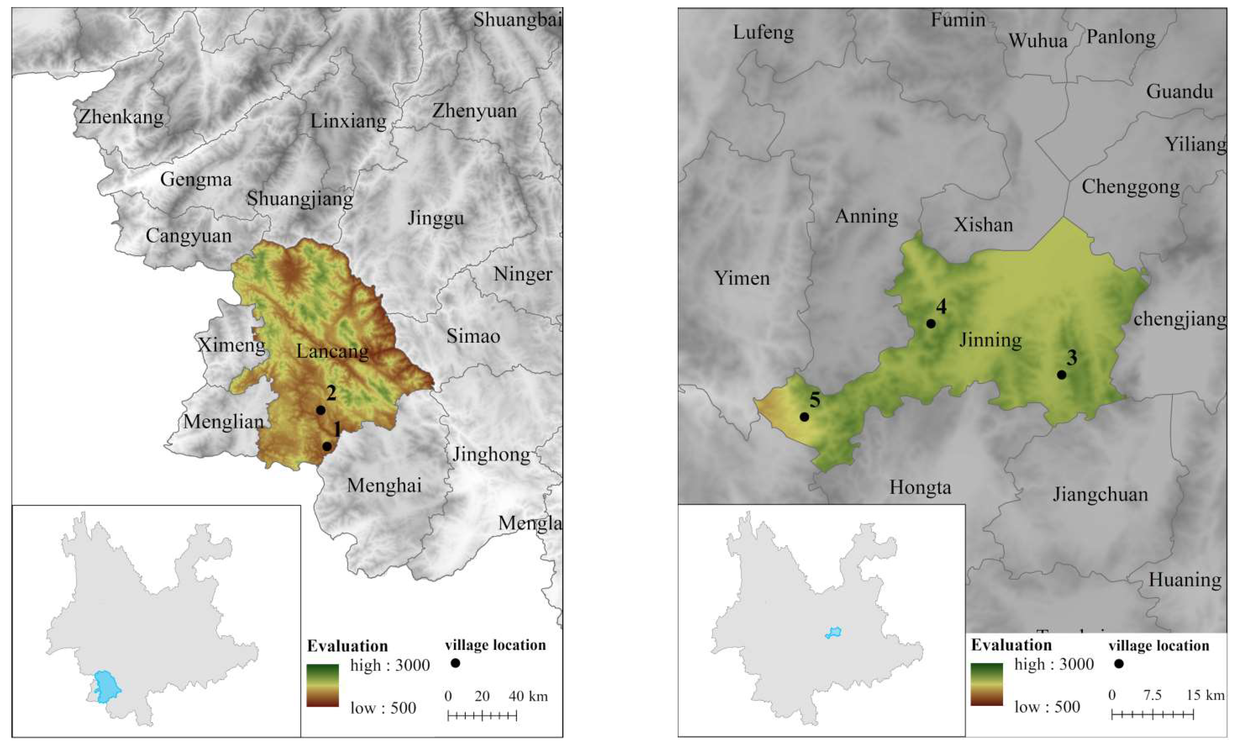
Characterized by a certain sense of territoriality, villages represent fixed and controllable spaces that are demarcated by people within the natural environment, which naturally imbues them with a sense of place. A village can be analyzed within this space based on its dimensions, explicitly using the “Long Axis” and “Short Axis”. Here, the “Long Axis” refers to the most extended straight-line length of the village, which is often aligned with the primary developmental direction or main road. Conversely, the “Short Axis” denotes the village’s maximum width, represented by the lengthiest straight line perpendicular to the Long Axis. These axes are pivotal in defining the village’s spatial attributes and overall configuration. Based on the unique characteristics of the studied traditional villages, we established three dimensions: 100 m, 30 m, and 7 m. These dimensions facilitated the analysis of the village boundary forms from a macroscopic large boundary, intermediate medium boundary, and micro-level small boundary perspective. As can be seen from
Table 1, the longer the perimeter is, the larger the space fractal dimension will be, which signifies the stronger boundary integration ability of a space. A stronger integration ability means more buildings can be organized in a smaller public space, and thus the basic form of a village is formed. We could find from the different fractal dimensions in Table 5 that the fractal dimensions of the five villages are 1.1391 (Xiangshui Village), 1.1016 (Nuogan Village), 1.2045 (Sanyin Village), 1.0968 (Yazu Village), and 1.2179 (Mangjing Village), respectively. The fractal dimensions calculated for the five villages provided a nuanced understanding of their spatial characteristics. For instance, the higher fractal dimension of Mangjing Village (1.2179) signifies a stronger boundary integration ability, implying a higher level of spatial complexity. This aspect of spatial analysis, rooted in fractal theory, showcases the intricate spatial arrangements inherent in traditional village layouts, providing a robust basis for evaluating the impact of urbanization and other transformations on these heritage sites. These three dimensions, as the maximum value that a virtual boundary could span, link the boundary points of the villages and highlight the three layers of more accurate village boundaries, which provides a relatively accurate basis for village boundary research.
The primary goal in this study was to develop a quantitative method for characterizing the spatial layouts of traditional ethnic minority villages in Yunnan. Recognizing the importance of understanding these traditional village forms, the research also emphasizes their significance for heritage conservation and urban planning. This exploration aimed to create a more effective quantifiable indicator scheme for capturing the morphological features observed during village construction. Villages’ spatial plane morphological order was analyzed using principles derived from urban and rural planning studies. Specifically, we drew upon concepts related to the “settlement in public space”, a theory that examines how public spaces within settlements influence their spatial morphology [
13]. This approach allowed us to derive corresponding quantitative indicators for the village space plane form.
4.1. Length/Width Ratio
Village form can be judged through the length/width ratio. With the data of the major and minor axes of the five villages obtained through data collection with oblique photography technology and the length/width ratio of the five villages, respectively, according to Formula (1), the forms of the five villages can be screened.
The length/width ratio statistical results of the five villages in
Table 2 were obtained via the length/width ratio calculation as per Formula (1). According to
Table 2, the length/width ratio of Xiangshui Village, Nuogan Village, Sanyin Village, Yazu Village, and Mangjing Village is 1.4335, 1.0487, 1.8952, 1.9142, and 2.4326, respectively. The village boundary graph will show the main features of the ribbon when
λ is higher than 2; therefore, Mangjing Village was judged to be a ribbon-type village according to the data. The village boundary graph will show the main features of a cluster when
λ is lower than 1.5; therefore, Xiangshui Village and Nuogan Village were judged to be cluster-type villages. When λ is within the range of 1.5–2, the village boundary graph is a non-typical cluster and a non-typical ribbon, i.e., showing a cluster-type village with a ribbon tendency. It could thus be judged, according to the data, that Sanya Village and Yazu Village are cluster-type villages with a ribbon tendency.
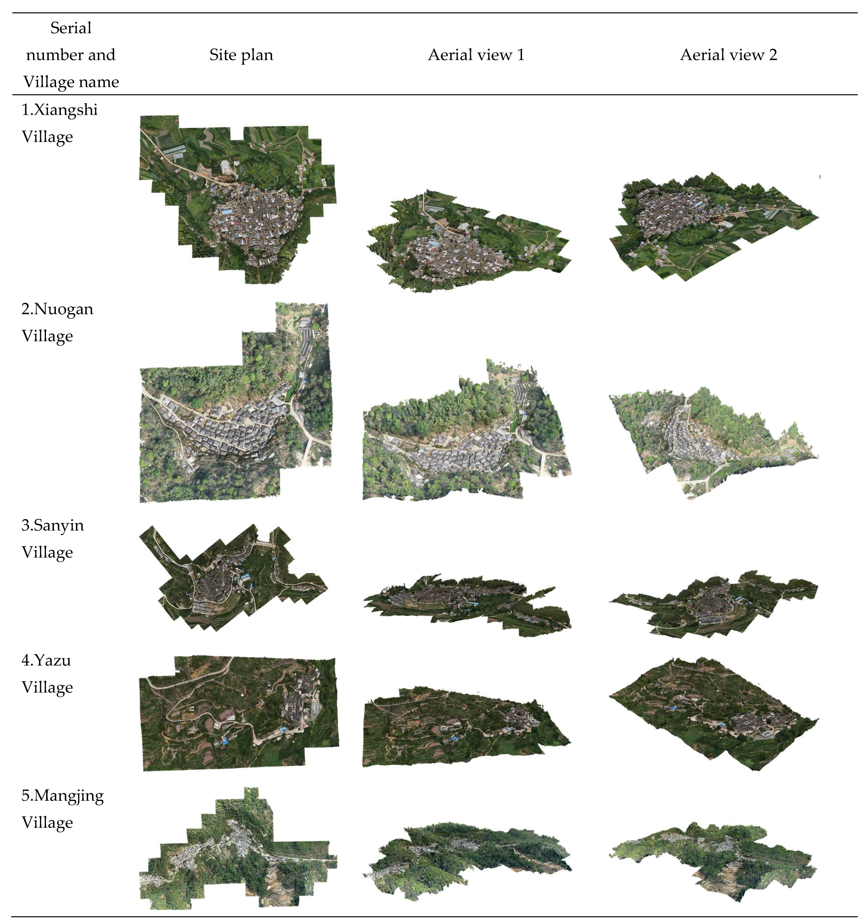
A village is generally a cluster-type village if the length/width ratio exceeds 1.5. As demonstrated by the oblique photography models of Xiangshui Village and Nuogan Village, there were no significant extensions at either end of the boundary graphs in these two villages. This is the most typical village form, which is generally found in any relatively flat place. A village is a ribbon-type village when the length/width ratio exceeds 2. According to the oblique photography model of Mangjing Village, the buildings in this village are usually extended along a linear direction.
4.2. Perimeter/Area Ratio
The 2D plane of a village is a closed geometric graph, which is preliminarily judged usually through some primary data (e.g., major and minor axes, perimeter and area). Since the boundary space scale of a traditional village could be objectively analyzed with the village’s medium boundary dimension, the five villages’ medium boundary dimension data were used in the operation of Formula (2).
Table 3 was obtained after substituting data into the formula.
As found while measuring the village boundary virtual space, the boundary constantly shrinks inwards. The longer the perimeter, the smaller the area and the bigger the perimeter/area ratio. According to
Table 3, the perimeter/area ratio of the five villages is 0.026 (Xiangshui Village), 0.034 (Nuogan Village), 0.042 (Sanyin Village), 0.034 (Yazu Village), and 0.039 (Mangjing Village). Thus, the perimeter/area ratio of the five villages is within the range of 0.026~0.042, and the data of the perimeter and area stay within the definite steady range.
After the constant data substitution and ratio analysis, it was found that where the P (perimeter) is definite, the maximum area is a circle. On the contrary, P (perimeter) could be infinitely large if A (area) is fixed. We found, by comparing the data obtained for the perimeter/area ratio, that a bigger ratio signifies a longer perimeter (denominator), while a longer perimeter means more lines should be used for a village boundary closed graph with the same area, which verifies, from another point of view, that the boundary shape of this village is more complicated. It can thus be seen from the data obtained for the perimeter/area ratio of the five villages that the perimeter/area ratio of Sanyin Village and Mangjing Village is relatively large, and the boundary shape of the two villages is more complicated.
The morphological features reflected by the values calculated with this method are insignificant because they only show that the perimeter/area ratio decreases with the increase in area, and therefore, they could be used as a reference for simple auxiliary information.
4.3. Shape Index
Formula operations were further carried out according to the basic data of the five villages based on data obtained with the calculation formulas of length/width ratio, perimeter, and area; the three big-, medium-, and small-scale virtual boundary data of the villages can be substituted into Formula (3), and the S
big, S
medium, and S
small values of the shape index of village boundaries under difference scales were calculated. Meanwhile, weighted averaging of the shape index was performed as per Formula (4) to obtain the final shape index and analyze the boundary complexity and structure saturation more accurately and meticulously. Finally,
Table 4 shows the data summary.
In landscape ecology, the shape index is generally expressed as the boundary complexity and structure saturation that the research object shows in a 2D-plane graph. A bigger shape index signifies higher shape fragmentation and complexity.
We can see from the data in the table that the shape indices of Xiangshui Village are 1.8315, 2.4838, and 4.9190, respectively, and the weighted average of the shape indices is 2.7510. Thus, the shape index of Xiangshui Village increases constantly with the continuous shrinkage of the boundary, and the weighted average of the shape indices of Xiangshui Village is within the range of the fractal dimensions of the two values, i.e., Sbig and Smedium. For instance, the features of Xiangshui Village are identical to those of the other four villages. As the dimensions of the virtual boundary space are continuously adjusted, the area tends to become smaller, while the perimeter tends to become longer. This adjustment reflects the changes in spatial configuration within the village boundary, which is possibly driven by various factors, such as urbanization, population dynamics, or conservation efforts. In this paper, the term “virtual boundary space” refers to the geometric representation of village boundaries in a 2D plane, which is utilized to understand the spatial morphology of traditional villages. The closer the value, the more probable it is that the reflected boundary graph of a traditional village will be a circle.
The area will become smaller and the perimeter will become longer with the constant shrinkage of virtual space. Concurrently, it could be inferred from the perimeter/area ratio analysis that a higher boundary fragmentation corresponds to a lesser resemblance to a circle. Therefore, the weighted average of shape indices was used as a relatively accurate datum for analysis. As shown by the weighted average in
Table 4, the shape index of both Nuogan Village and Yazu Village was closer to 1, which implies that the boundary graph shapes of these two villages are closer to a circle and boundary fragmentation is relatively low. Given that the shape indices obtained through the weighted averages for Xiangshui Village, Sanyin Village, and Mangjing Village are all close to 3, it can be concluded that the boundary fragmentation and complexity in these three villages are relatively high.
4.4. Village Analysis
This study aimed to measure the compactness of a village’s spatial structure using the fractal dimension of its 2D-plane graph. Fractal dimensions are instrumental in urban studies, allowing for the quantification of spatial patterns and complexities [
31,
32]. Specifically, in the realm of urban preservation, these dimensions provide insights into the spatial integration and compactness of settlements, which are crucial for devising effective conservation strategies. For a more nuanced understanding of the spatial morphology of traditional villages, fractal theory was adopted. This research categorized the fractal dimensions into three distinct ranges: low equal dimensions (1.0–1.1), medium equal dimensions (1.1–1.2), and high equal dimensions (above 1.2). To gain a more intuitive insight into a village’s overall boundary form, this research focused on the village’s medium boundary dimension. By substituting the perimeter and area of the medium boundary dimensions of five villages into Formula (5), we calculated the fractal dimensions, as presented in
Table 5.
A longer perimeter indicates a larger fractal dimension, signifying a stronger boundary integration ability within the space. This enhanced integration ability suggests that a greater number of buildings can be organized within a limited public space, leading to the formation of a village’s primary structure. As shown in
Table 5, we observed varying fractal dimensions for the five villages: 1.1391 for Xiangshui Village, 1.1016 for Nuogan Village, 1.2045 for Sanyin Village, 1.0968 for Yazu Village, and 1.2179 for Mangjing Village. These dimensions were further analyzed and divided into three ranges: low (1.0–1.1), medium (1.1–1.2), and high (above 1.2), providing a comprehensive understanding of each village’s spatial characteristics.
5. Discussion
In the evolving field of landscape ecology and its intricate analyses, this study aimed to introduce a methodological innovation to determine the boundary complexities and structural saturation of traditional villages. The research path and findings are described as follows.
5.1. Effectiveness and Validation
This study successfully introduced a shape index analysis method, differentiating between macro (Sbig) and micro (Ssmall) spatial aspects of village boundaries. The applicability and effectiveness of this method were thoroughly validated, demonstrating its theoretical and practical significance in interpreting 2D village boundaries. The applicability and efficacy of this method were rigorously validated, demonstrating that it holds theoretical merit and practical relevance in interpreting 2D village boundaries.
5.2. Accuracy and Comparative Advantages
Our method unequivocally showcased a superior degree of accuracy when juxtaposed with manual measurements and methods cited in the extant literature [
12,
13]. Specifically, traditional methods often rely on manual measurements, which can introduce human error and lack the precision of modern technological tools. Our approach, which combines oblique photography technology with quantitative indices, allows for a more detailed and accurate representation of village morphologies. Furthermore, the integration of multiple quantitative indices provides a comprehensive assessment, capturing nuances that might be overlooked in other methodologies. The methodological advances presented in this research cater to a broader audience by providing more background information and examples of the application of quantitative indices in conservation planning. The visual representation of boundary characteristics through oblique photography and quantitative analysis offers a straightforward understanding for individuals regardless of their mathematical background, thus making this study more accessible and applicable in multidisciplinary conservation planning contexts.
5.3. Upon Comparison
It was noted that traditional manual measurements tend to exhibit a certain degree of error when determining the total area of the village, the number and distribution of buildings, and the length and width of roads. The application of UAV image technology and advanced spatial analysis tools in this study significantly mitigated these inaccuracies, offering a more precise and detailed data set for analyzing spatial patterns. This comparative analysis accentuates the superior accuracy and comprehensive assessment afforded by the methodology employed in this study in contrast to the conventional manual measurements.
5.4. Future Avenues for Optimization
Recognizing imperfections provides a pathway for future refinements. Integrating high-resolution remote sensing techniques, as championed by several researchers [
19,
20], could amplify the spatial resolution and detail. Adopting multispectral radiometric analyses and the combination of GIS and remote sensing can potentially usher in a new era of precision in this domain. With the rapid advancement of computational models, embracing deep learning techniques, such as those proposed in recent studies [
26], can further propel the accuracy and granularity of future boundary analyses.
This research introduces an innovative and comprehensive methodology with which to analyze traditional village boundaries. Despite existing challenges, this foundational work sets the stage for subsequent studies in this domain. The method’s integration of distinct boundary dimensions, rooted in Professor Pu Xincheng’s theoretical foundations, has filled an existing research gap. This advanced approach, emphasizing the delicate balance between Sbig and Ssmall, aids in delivering a more comprehensive and nuanced perspective on traditional village layouts, thereby enriching the broader field of landscape ecology.
6. Conclusions
This research embarked on a mission to delve deep into the spatial morphology of traditional villages, leveraging the power of oblique photography and quantitative indices. Through its rigorous methodology, the research has not only categorized village forms using length/width, perimeter/area ratios, and shape index calculations but also unveiled the distinctive spatial patterns of five villages in Yunnan Province. By integrating fractal dimensions, we have added depth to our understanding of these villages’ layout. The endeavor aimed to seamlessly blend contemporary analytical methods with the rich heritage embedded in village layouts. The insights garnered from this study not only enrich the comprehension of village morphologies but also set the stage for subsequent research in landscape ecology. Furthermore, the findings of this study bear significant implications for heritage conservation and the challenges posed by urbanization, emphasizing the need for sustainable and informed urban planning strategies in the future.
This study comprehensively analyzed traditional village spatial morphology using oblique photography technology and quantitative indices. The utilization of length/width and perimeter/area ratios, coupled with shape index calculations, facilitated the categorization and quantitative assessment of village forms and complexities. By considering weighted averages of shape indices, villages were categorized based on boundary configurations, offering insights into their spatial patterns. Incorporating fractal dimensions provided an additional layer of assessment, evaluating spatial integration. The application of this methodology to five Yunnan Province villages exemplified its effectiveness in revealing unique village forms and complexities, including the presentation of 2D-plane graphs. This research contributes to understanding traditional village morphologies, providing valuable implications for heritage conservation and urban planning.
This study provides a solid foundation for the application of quantitative methods in conservation and boundary protection practices. The methodological framework developed herein can significantly contribute to heritage conservation efforts by providing a precise understanding of the spatial morphology of traditional villages. Moreover, the insights garnered can inform urban planning strategies, ensuring a harmonious balance between the preservation of cultural heritage and modern urbanization needs.
The methodological framework proposed in this study is not confined to the analysis of traditional villages but holds promise for a broader application in urban planning, environmental protection, and other relevant spatial analysis domains. By adapting the methodology to other contexts, a more holistic understanding of spatial morphologies across different settings can be achieved, contributing to sustainable development and place making in contemporary urban environments.


