Article

Integrated Mining and Reclamation Practices Enhance Sustainable Land Use: A Case Study in Huainan Coalfield, China

1
School of Environment Science & Spatial Informatics, China University of Mining & Technology, Daxue Road 1#, Xuzhou 221116, China
2
Institute of Land Reclamation & Ecological Restoration, China University of Mining & Technology (Beijing), Beijing 100083, China
3
School of Public Policy & Management, China University of Mining & Technology, Daxue Road 1#, Xuzhou 221116, China
*
Author to whom correspondence should be addressed.
Land 2023, 12(11), 1994; https://doi.org/10.3390/land12111994
Submission received: 19 September 2023 / Revised: 12 October 2023 / Accepted: 30 October 2023 / Published: 31 October 2023

Abstract

:
In the coal-grain composite area (CGCA) of eastern China with a high groundwater table (HGT), underground coal mining subsidence has caused extensive submergence of farmland, posing a significant threat to regional food security. Currently, land reclamation techniques in mining subsidence areas primarily focus on post-mining reclamation (PMR) of stable subsidence land with a low reclamation rate. This study investigated the application of concurrent mining and reclamation (CMR) technology for unstable subsidence land in a representative HGT mining area, namely the Guqiao Coal Mine in the Huainan Coalfield. Firstly, mining subsidence prediction and geographic information technology were employed to simulate the spatio-temporal evolution of dynamic mining subsidence, taking into consideration the mining plan. Subsequently, phased reclamation parameters were quantitatively designed by integrating the dynamic mining subsidence and surface reclamation measures. Lastly, scenario simulations were conducted to discuss the effectiveness of CMR in comparison with non-reclamation (NR) and PMR. Additionally, reclamation and ecological restoration strategies for coal mining subsidence areas with comprehensive governance modes were proposed. The findings indicated that mining activities have led to a reduction in both the quantity and quality of original farmland, with 70% of the farmland submerged and rendered uncultivable. In contrast to PMR, which achieved a reclamation rate of 29%, CMR can significantly increase the farmland reclamation rate to 69% while also prolonging the service life of farmland. This study provides theoretical support and technical references for promoting sustainable mining practices, protecting farmland, and facilitating the high-quality development of coal resource-based cities.

1. Introduction

Farmland is a critical natural resource for food security, environmental security, and sustainable development. The problems of resource consumption and environmental degradation caused by population growth, urban expansion, and economic development are threatening arable land resources in many parts of the world [1]. Mining, especially coal mining, is a critical factor contributing to land degradation globally. This occurrence is widespread in developed countries including the United States [2], Poland [3,4], Australia [5], the Czech Republic [6], and Germany [7], as well as in emerging economies such as China [8], India [9], Ukraine [10], Turkey [11], and Indonesia [12].
Coal retains a crucial role in China’s primary energy consumption and will maintain its importance over the next three decades [13]. However, the large-scale exploitation of coal resources, 92% of which are derived from underground mining, inevitably leads to environmental and land damage in mining subsidence areas [14,15]. Mining 10,000 tons of underground coal is estimated to cause a subsidence area of 0.20 to 0.33 ha [16].
In mining areas with HGT, ground subsidence leads to an increase in the water table and soil moisture [17]. If the subsidence depth surpasses the burial depth of the water table, a permanent waterlogging region is created, causing a decline in agricultural productivity. Areas adjacent to regions with relatively lower subsidence encounter seasonal waterlogging and swampiness during periods of heavy rainfall. Conversely, compacted land parcels are formed during the dry seasons. Furthermore, the subsidence caused by mining changes the shape of landforms, leading to steeper slopes, heightened erosion, lower soil quality, and diminished agricultural yields, as shown in Figure 1. Subsidence waterlogging resulting from coal mining has been reported in Berkeley, United States [18], Southern Poland’s Upper Silesia [19,20], India’s Raigarh [21], Pontes and Blanchet in Spain [22], as well as other nations, demonstrating that this is a global geological crisis triggered by underground extraction [23].
In the CGCA of China, encompassing provinces such as Jiangsu, Anhui, Shandong, Henan, and Hebei, these issues are particularly prominent [24]. This region boasts abundant coal resources and has a long history of agricultural production, with vast expanses of arable land. In 2020, coal and grain production accounted for 9.9% and 35.6% of the country’s total output (Figure 2a), respectively, thereby making significant contributions to ensuring national energy security, food security, and rapid societal development. Regions characterized by HGT are susceptible to water accumulation on the surface due to mining subsidence, which can destroy substantial areas of arable land.
The protection of farmland is a fundamental national policy set forth by the Chinese government [25], which has implemented a rigorous system to safeguard it. As a key technical guarantee for the reuse of land resources, land reclamation in the mining area has been greatly developed. Many reclamation techniques have been tested and popularized, such as the use of coal gangue, fly ash, dredged sediment, and other solid wastes in coal mining subsidence land for filling reclamation, land leveling, water drainage, and the deep-digging and shallow-filling methods [26] for non-filling reclamation. However, these reclamation techniques are primarily intended for coal mining subsidence land that has been stabilized.
Most coal mines in the CGCA of China exhibit the features of multiple coal seams, resulting in significant and long-lasting subsidence due to repeated mining [27]. The delayed PMR can result in prolonged farmland barrenness. This period not only leads to the wastage of land resources but also to the deterioration of the ecological environment, such as soil erosion and salinization, thereby increasing the challenges in future reclamation efforts. Simultaneously, a significant amount of highly productive topsoil resources are submerged and permanently lost in HGT mining subsidence areas, resulting in a drastic decrease in both the quality and quantity of reclaimed farmland [28]. The theories and practical experiences of land reclamation that have arisen from this foundation are inadequate for fulfilling the necessities of current intensive mining practices and progressively improving ecologic environmental management standards. The protection of the quantity and improvement of the quality of arable land in the CGCA is facing higher requirements.
Dynamic reclamation methods have become a recent research focus, aiming to implement reclamation measures during land subsidence [29]. The objective is to shorten reclamation periods and reduce land barrenness duration, enhancing land utilization efficiency and promoting healthy and orderly development in mining subsidence areas. Based on technology for reclaiming unstable coal mining subsidence land in China, Hu [30] proposed the concept of CMR to mitigate the low land reclamation rate and lengthy reclamation period after stable subsidence.
Extensive research has been conducted on CMR in recent years, which remains a complex interdisciplinary system problem that necessitates the comprehensive application of disciplines such as geology, mining engineering, environmental science, landscape ecology, land science, and agronomy. The detailed construction plans throughout the whole lifecycle of a mine pose numerous challenges. The hasty implementation of CMR may fail to achieve the goals of land reclamation and quality improvement, serving merely as a temporary measure. Continuous mining operations can cause further subsidence, resulting in damage to the reclamation area. As a consequence, the effectiveness of ecological restoration and management efforts in mining sites may become limited.
This study presented an analysis of key technologies of CMR in coal mining subsidence areas, utilizing mining subsidence areas at the Guqiao coal mine in Huainan with typical HGT as an example. The general construction procedure for CMR was proposed based on land use and mining development requirements, integrating surface reclamation and underground mining plans through guidance from the theory of dynamic prediction in mining-induced subsidence. A method for surface reclamation was proposed based on the spatiotemporal evolution characteristics of mining subsidence, along with an approach for optimizing comprehensive ecological use in the affected area. The research results can assist in land reclamation planning in mining subsidence areas, relieving the conflict between human activity and the environment in CGCA, contributing to the sustainable utilization of land resources, and the green development of mining areas.

2. Materials and Methods
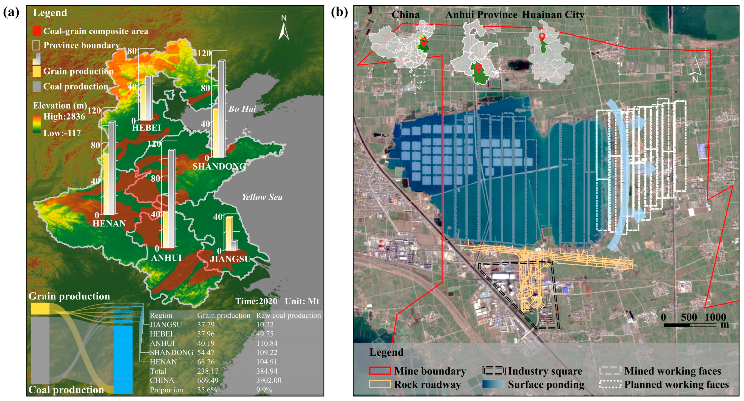
2.1. Study Area

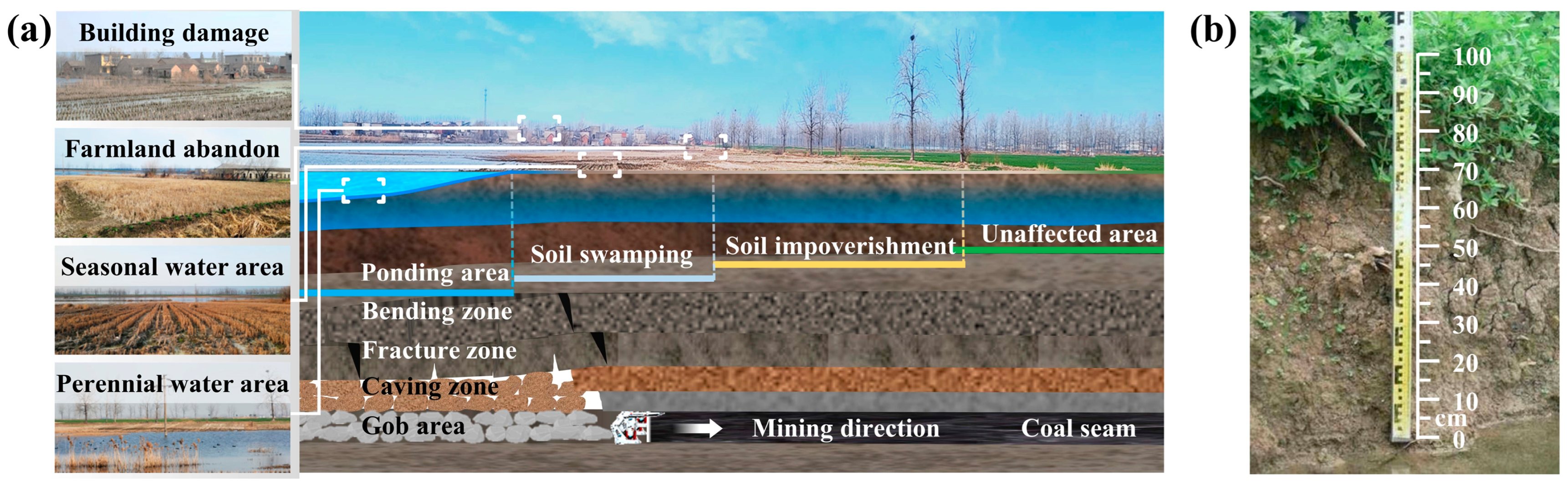
2.1.1. Geological and Mining Conditions

Located in the middle reaches of the Huaihe River, the Huainan mining area is one of China’s 14 major coal bases, and its coal mining is of irreplaceable strategic importance in bridging the energy gap in eastern China and ensuring regional economic development. At the same time, it is also one of China’s nine largest commercial grain bases, which plays an important role in ensuring regional food security, forming a typical coal–grain composite area. The coal-bearing sequences in Huainan consist primarily of Permian–Carboniferous formations, which are overlain by Cenozoic sedimentary strata. The strata consist of sandy conglomerates, fine to moderate sandstones, clays, and sandy clays with a thickness ranging from 200 m to 500 m. Tidal and sand ginger soils are the dominant soil types in the region. The climate of the coalfield is characterized by a humid/semi-humid continental monsoon, with an average annual temperature of around 15 °C. The area experiences an average annual sunshine duration of 1963 h. The mean annual precipitation is 962.12 mm, mostly falling from May to September. The average annual evaporation rate is 1181.3 mm.
Guqiao coal mine (116°32′06′′–116°38′53′′ E, 32°43′46′′–32°51′50′′ N) is located in the center of the Huainan mining area (Figure 2b). The mine production started in 2007, utilizing the upper coal seam 13-1 and lower coal seam 11-2, located at the center of the Permian Shanxi Group and the Upper and Lower Stone Box Formations. The production scale was 10 million tons per year. The coal seam 13-1 had an average thickness of 4.0 m, while coal seam 11-2 had an average thickness of 3.0 m with an average depth of 570 m and 650 m, respectively. A comprehensive mechanized coal mining method with full height at one time is utilized, along with the full caving method for roof management. The mining area features a flat terrain with an average elevation of 23.6 m, and the groundwater is typically found at a depth of 1.5 m below the surface. Land degradation is caused by water accumulation resulting from ground displacement, which is used as an indicator for assessing the impact of ground subsidence (Table 1). When the land subsidence exceeds the groundwater level, it forms a permanent waterlogged area, leading to the loss of fertile land. Regions where the land subsidence value is greater than 1.5 m are defined as severely degraded areas. When the land subsidence depth ranges from 0.5 m to 1 m, causing seasonal waterlogging, farmland is abandoned. Regions where the land subsidence value falls between 0.5 m and 1 m are categorized as moderately degraded areas. For areas where the subsidence depth is less than 0.5 m, surface deformation is minimal, and the area can be basically restored to use after land leveling. Such regions are defined as mildly degraded areas.

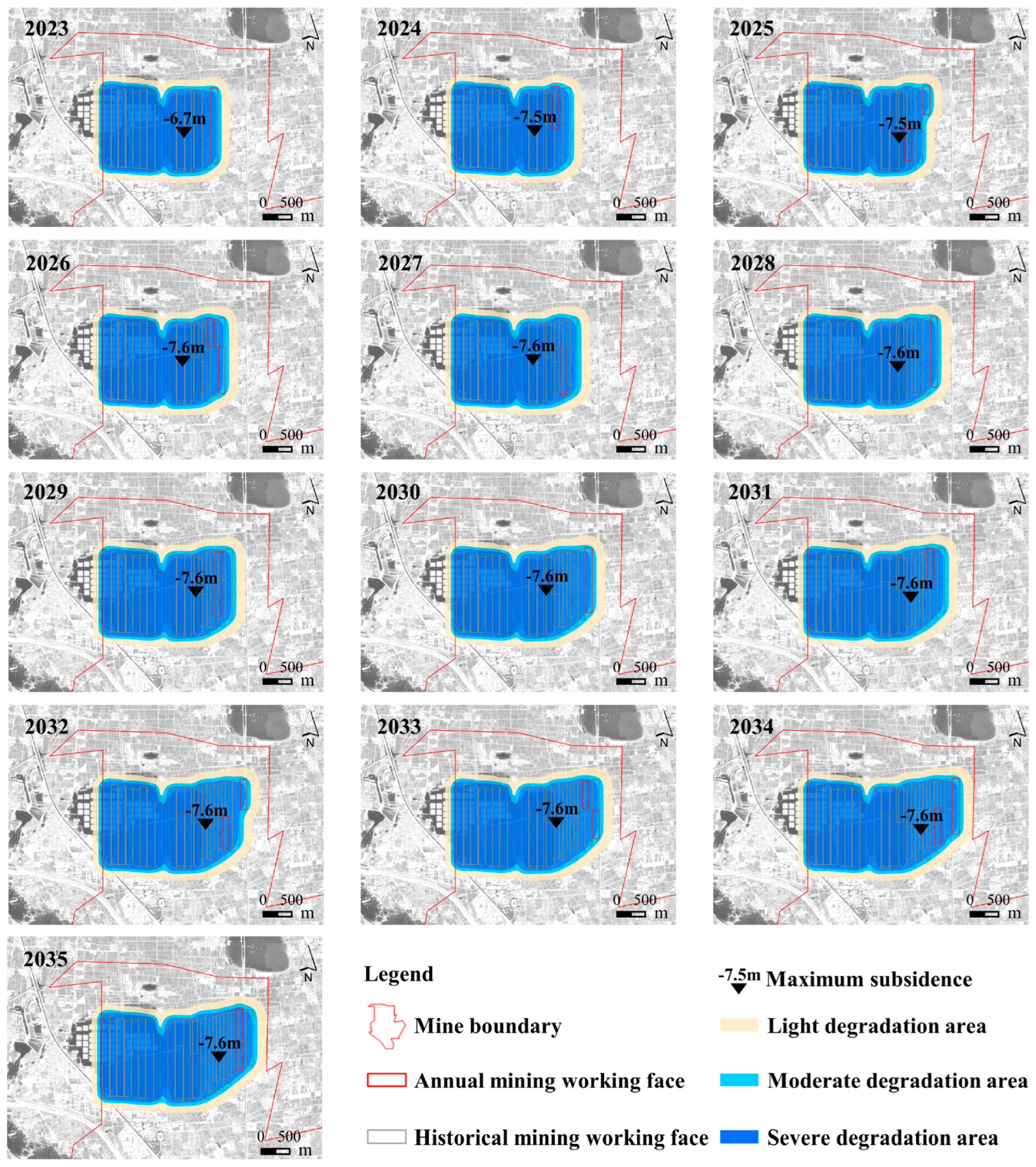
2.1.2. Current Surface Subsidence and Future Mining Plans

The Guqiao coal mine is recognized for its thick, unconsolidated sedimentary formations, considerable depth of excavation, use of multi-seam mining method, and close proximity to the groundwater table. These elements significantly affect the magnitude and seriousness of surface subsidence in the region.
The goaf, which has been developing over a decade of subterranean underground mining, has led to a considerable surface subsidence ponding area of 1000 ha in 2022, as shown in Figure 2.
Before mining operations, the area’s ecosystem was primarily agricultural land. Subsequent underground mining inflicted severe damage, resulting in the ponding of 1132 ha of farmland due to inadequate management.
Due to the high cost and insufficient availability of filling materials, such as gangue, and the significant investment required for filling mining, Guqiao coal mine has not yet implemented this technology. With continuous large-scale coal mining, the cultivated land is undergoing dynamic subsidence, which leads to waterlogging and the formation of a water body, thereby increasing the proportion of affected cultivated land. In the future, coal resource mining activities will persist, and their impact on land use will endure.

2.2. Data Source

In this study, the probability integral method is used to predict the spatial and temporal distribution of the coal mine subsidence area based on the mining face layout, mining plan, and subsidence prediction parameters of the mining area. Based on the zoning standard, ArcGIS 10.5 software was used to reclassify land use, and the land and water layout of the reclamation planning area was simulated based on the principle of earthwork balance.

2.3. Methods

2.3.1. Mining Subsidence Prediction
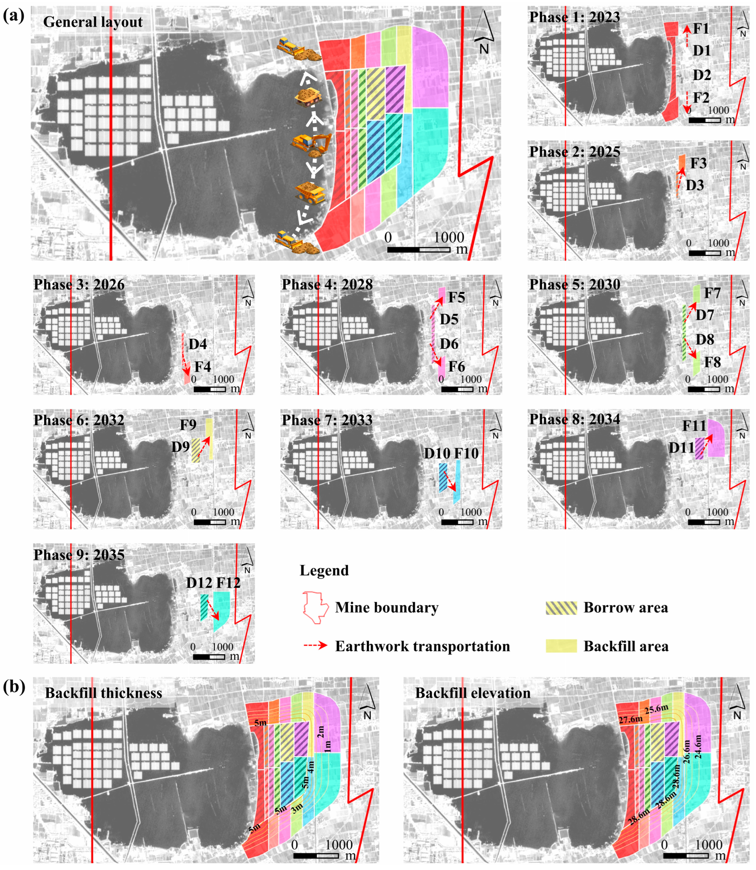
In order to promote the scientific and orderly development of land reclamation and ecological environment restoration, it is necessary to carry out inversion prediction and evaluation of the historical land damage and the impact of future mining on the ecological environment and to study and formulate practical measures and methods of land reclamation and environmental restoration.
The Probability-integral method is widely used in surface subsidence prediction of underground longwall mining currently [31]. This method treats the combined rock-soil mass as a stochastic medium and views the movement of rock as a stochastic process. According to the superposition principle, the model can be derived as follows [32]:
W e x = 1 r e π x 2 r 2
The subsidence of the surface (x, y) caused by the underground mining unit (s, t) in the three-dimensional space is as follows:
W e x , y = 1 r 2 e π x s 2 + y t 2 r 2
When the length of the mining area is L, and the width is l, the prediction equation for the subsidence of the arbitrary point (x, y) caused by the entire mining process is as follows:
W x , y = W 0 0 l 0 L 1 r 2 e π x s 2 + y t 2 r 2 d t d s
where W 0 ( = m q c o s α ) is the maximum surface subsidence value during the whole mining process; m represents the mining thickness; q represents the subsidence factor; α represents the coal seam dip angle; r ( = H 0 / t a n β ) is the main influence radius; H0 represents the average mining depth, and tanβ is the tangent of the main effect angle; l is the strike length of the ideal coal seam, given by l ( = D 1 S 1 S 2 ) and D1 is the strike length of the real coal seam; L is the dip length of the ideal coal seam, given by L ( = ( D 3 S 3 S 4 ) × s i n ( θ + α ) / s i n θ 0 ) and D3 is the dip length of the real coal seam; θ0 is the effect transference angle; and S1, S2, S3, and S4 represent the left, right, raise, and dip deviations of the inflection point, respectively.
The parameters required to predict surface deformation are determined by a combination of the availability of on-site monitoring data, the layout of the working faces, the mine plan and mining method, and the lithology of the overlying strata, including a subsidence factor (q) of 0.85, a repeated mining subsidence factor (qr) of 0.93, a displacement factor (b) of 0.32, a tangent of the main influence angle (tanβ) of 2.2, an offset distance of the inflection point (S) of 0, and an influence transference angle (θ) of 89°.
Mining subsidence estimation is realized by the more mature domestic application of mining subsidence prediction system (MSPS) software, which can achieve more than 90% accuracy in the plain area [33]. Combined with the coal mining succession plan, this study designates the termination of all mining in the upper and lower coal seams as the predicted timeframe (2023–2035). At yearly intervals, the extent of mining-induced subsidence is projected to gather various crucial information necessary for the design of the CMR program. This involves primarily the survey of surface subsidence, comprising location, extent, and depth, along with the concurrent survey of waterlogged areas, encompassing time, location, and extent.
A significant tendency towards waterlogging has been observed in HGT regions. After obtaining the topography before and after mining subsidence, it is necessary to determine the extent of waterlogging. The regional groundwater burial depth can be used in conjunction with the predicted subsidence results. The burial depth of the groundwater is −1.5 m in the study area; areas with subsidence greater than 1.5 m are considered submerged by water, while the range delimited by contour lines with subsidence greater than 0.5 m but less than 1.5 m is categorized as moderately seasonally waterlogged. Typically, the −10 mm subsidence contour line is used as the boundary of coal mining disturbance impact and serves as the baseline for land reclamation.

2.3.2. CMR Planning

The processing of reclamation data for mining subsidence land involves various factors, such as mining, geography, land, and agriculture. These data also present significant features, such as a considerable amount of information, complicated information properties, and notable spatiotemporal changes. ArcGIS is a software specialized in processing and managing spatial data, equipped with a wide range of features for massive data management, manipulation, retrieval, statistical analysis, and external publication. It satisfies the coal mining land reclamation system needs [34,35].
Initially, the MSPS software’s contour lines obtained for surface subsidence are transformed into vector data using ArcGIS software. The digital elevation model of surface subsidence is generated by creating a triangulated irregular network (TIN) using the elevation field and the TIN to Raster function.
Post-subsidence terrain data are obtained by overlaying the original landform with the predicted digital elevation model of subsidence through the ArcGIS software’s spatial analysis capability. Then, utilizing predetermined standards for classifying surface damage levels, the extent of coal mining’s impact on surface damage characteristics is measured.
Using the Cut/Fill feature in the 3D Analyst Tools, the excavation and filling balance on mining subsidence land is analyzed to design the reclamation layout.
The core CMR process includes:
  • Divide the mining subsidence prediction phases according to the mining plan, and use the probability integration method to predict the dynamic subsidence contour of each mining phase. At the same time, based on the final subsidence contour after the end of mining, the total reclamation area is determined.
  • Based on the principle of earthwork balance and the process of deep-digging and shallow-filling, the general layout of the soil excavation area and the backfilling area is designed.
  • Based on the dynamic subsidence scope and the principle of earth balance, the phased reclamation area is determined, and the layout and elevation of the soil extraction and backfilling areas are designed.
At the implementation stage, the construction mainly includes geomorphic remodeling, soil reconstruction, and re-vegetation techniques, and the technical flowchart of CMR is shown in Figure 3.

3. Results

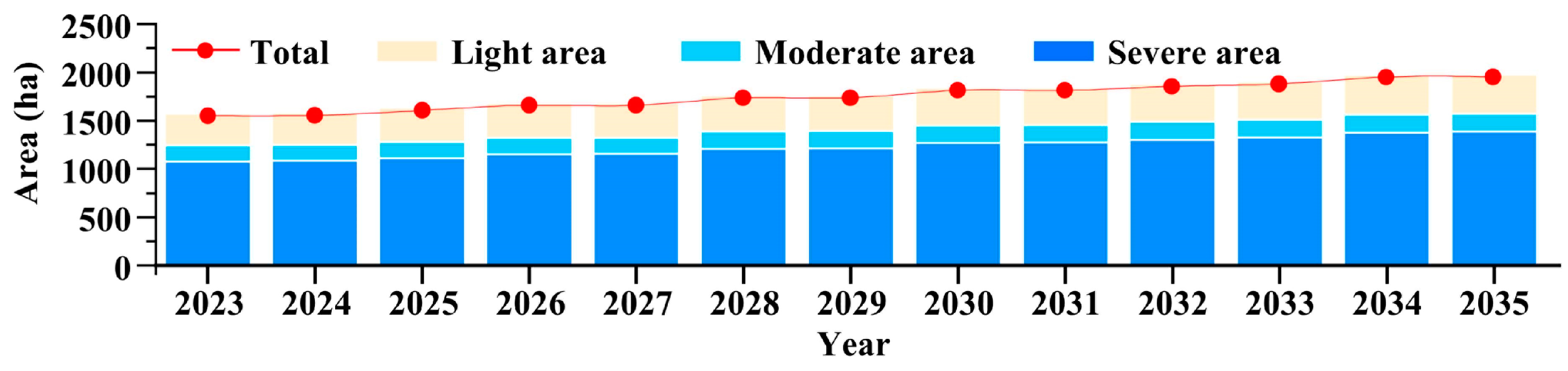
3.1. Spatio-Temporal Evolution of Simulated Mining-Induced Subsidence and Surface Ponding

Due to the short time interval and close distance of the mining face, the adjacent mining has a great influence on the subsidence of the mined area. Most of the land begins to collapse again without sinking steadily (Figure 4); that is, the land to be destroyed is always in an alternating sinking state. Based on predictions about mining subsidence, the surface is expected to sink by a maximum of 6.7 m after mining ends in 2023. By 2026, the maximum subsidence value had reached 7.6 m, and this maximum subsidence value was maintained in the subsequent mining process. With the development of coal mining activities, the collapse area is a dynamic process of increasing year by year. According to the predicted results of mining subsidence in the mining area, the evolution trend of water accumulation was consistent with the mining process of the working face.
The area statistics of land damage zoning from 2023 to 2035 are shown in Figure 5. After the first stage of mining, the surface began to sink. Based on the existing subsidence water area, it expanded eastward with the new subsidence caused by the mining area of the working face. At that time, the total subsidence area of the surface affected by coal mining reached 1577 ha, of which the light damage area was 334 ha, the moderate damage area was 160 ha, and the heavy damage area was 1083 ha. The area of perennial and seasonal water accumulation accounts for 79% of the total subsidence area, which means that this part of the land is transformed from high-quality farmland to a water accumulation area.
With the continuous eastward mining of the working face, the range of surface subsidence and water accumulation area also expands. By 2035, after the completion of coal seam mining, the mining subsidence area has reached 1981 ha, of which the water accumulation area is 1576 ha, accounting for 80% of the total subsidence area. According to the simulation of mining subsidence, due to the high-intensity underground mining and the geological characteristics of high groundwater level in the study area, about 80% of the land will be lost in the water after mining, which poses a fatal threat to regional food security and sustainable development.

3.2. Phased Reclamation Planning Combined with Mining Subsidence Evolution

Land transformation in mining areas involves the subsidence of cultivated land and its accumulation of water. Surface subsidence significantly impacts the pace and effectiveness of land reclamation in mining subsidence areas. Therefore, it is crucial to arrange the planning and construction sequence of mining areas based on the land subsidence process in a reasonable manner.
According to the coal mining plan for the study area, the reclamation period is set for 13 years from 2023 to 2035, and the historical subsidence water area falls outside of the planning scope. The main engineering measures of land reclamation are non-filling CMR technology based on deep-digging and shallow-filling.
The boundary for deep-digging and shallow-filling is set at a surface subsidence of −0.1 m, considering the influence range of the final surface subsidence of the study area and the demand for crop growth. Land leveling construction is confined to areas where settlement is under 0.1 m. To maintain earthwork balance, an optimized general layout is established for the soil extraction and backfill areas with a soil extraction depth of −3 m. The phased soil extraction area is chosen as the intersecting space between the phased severely damaged area and the general soil extraction area. According to the mining process and the degree of annual subsidence, the construction sequence of deep-digging and shallow-filling is set to nine stages.
The salvage time for the topsoil during ground subsidence depends on various factors. To ensure efficient construction and maximum soil volume, surface soil is promptly removed from the excavation area and transported to the nearby backfill site in the absence of subsidence. The construction of deep-digging and shallow-filling is divided into 24 zones (Figure 6). For example, the northern reclamation project planned for 2023 in Phase 1 will involve digging the soil from the D1 area and filling it to the F1 area. The phased reclamation plan is specifically targeted toward the area that will undergo mining subsidence in the following year.
The reclamation elevation following the stabilization of ground subsidence is a crucial factor determining the effectiveness of CMR. Similarly, taking into account both crop growth suitability and reclamation rate, the elevation of reclaimed farmland after stabilization is set at −0.1 m.
Based on the designated reclamation elevation after ground subsidence stabilization and the final degree of settlement in the study area, the backfill thickness and elevation of each reclamation phase in the backfill area can be determined.
The specific phased earthwork allocation plans are shown in Figure 7.
Taking the first phase of reclamation as an example, the total area of soil excavation for this phase is 37.7 ha, with an available soil quantity of 1,130,000 m3 and a backfilling area of 56.4 ha. Upon the completion of the reclamation, the total area of soil excavation will be 206.6 ha, with a total soil quantity in construction of 6,200,000 m3, corresponding to a total backfilling area of 346.8 ha.

4. Discussion

4.1. Comparison of Land Use in Subsidence Area under Different Development Scenarios

According to the distribution status of mining subsidence areas and the established mining plan, the landscape evolution mode of the study area is primarily the transformation between subsidence wetlands and cultivated land under NR. With the utilization of coal resources, the subsidence area is expected to expand, causing an increase in the water accumulation region. By 2035, approximately 654.8 ha within the study area are projected to experience new surface subsidence based on the current water accumulation range. This subsidence will cover 463.4 ha of water accumulation. Moreover, an additional 191.4 ha of cultivated land will undergo degradation (Figure 8a).
The traditional PMR construct after the surface subsidence is stable, the land reclamation measures such as deep-digging shallow-filling and land-leveling are adopted, and the area with light subsidence at the edge of the subsidence area is reclaimed for agricultural use. At this point, the land has suffered significant damage, and the majority of subsided land is challenging to restore to its original state. It becomes a permanent water accumulation area, which can be transformed into a reservoir or fish pond through remediation. After 2035, the amount of earthwork available is 1,400,000 m3, and the area of agricultural land that can be reclaimed is 191.4 ha, accounting for 29% of the damaged area (Figure 8b).
CMR aims to perform topsoil stripping and subsoil excavation in areas that will be severely impacted in the future prior to the mining subsidence process. As a result, more high-quality soil can be obtained during the reclamation process to achieve a higher reclamation rate (Figure 8c). Through CMR, 6,200,000 m3 of soil can be obtained, the area of restored farmland is 448.4 ha, and the reclamation rate is 69%. At the same time, CMR shortens the reclamation duration to 9 years and prolongs the land use time of the subsidence area.

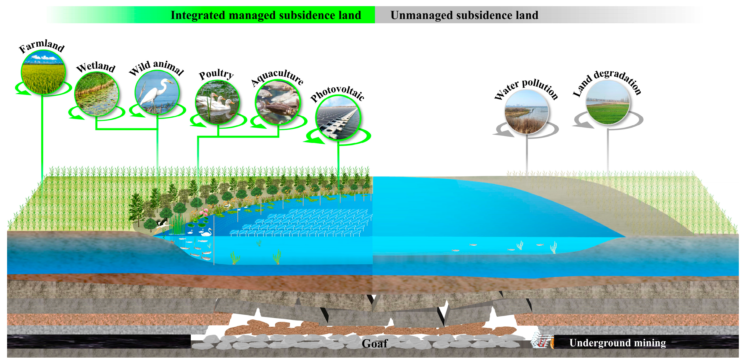
4.2. Ecological Reclamation Planning and Integrated Management of Mining Subsidence Land

The extraction of coal through underground mining results in surface subsidence and deformation, resulting in the formation of subsidence land. In areas with high groundwater levels, the primary consequence of mining subsidence on cultivated land is the elevation of groundwater caused by subsidence. As a significant portion of the water necessary for crop growth is sourced from the soil, the depth at which the groundwater is buried serves as a crucial determinant for ensuring optimal crop growth. When the local surface subsidence approaches or surpasses the depth of the subterranean water table, the surface will experience either temporary or permanent water accumulation, resulting in diminished crop yields due to waterlogging. In severe cases, this may lead to the complete loss of soil productivity. In addition, excessive local surface evaporation can result in soil salinization, causing soil to become supersaturated, resulting in gradual nutrient loss due to surface water or water diving through water leaching. This decline in productivity of cultivated land has led to land becoming unsuitable for farming, resulting in loss of cultivated land and land abandonment.
In addition, this lowered landform causes water to flow off rapidly and transport sediment to low points, resulting in adverse environmental effects on subsided water areas. For this reason, the rational utilization of land in the mining area, maximizing the restoration and utilization of land resources, and constructing a new ecological balance system have become integral considerations for promoting sustainable development in the mining area.
With the change in societal demands for ecological restoration and the rapid development of restoration technology, “overall protection, systematic restoration, and comprehensive management” are viewed as a practical response to the ecological degradation of the nation’s land. The management and repurposing of coal mining subsidence regions are no longer limited to agricultural production activities.
Degraded mining lands have the potential for regeneration, and reclamation efforts should encompass both productive and unproductive habitats. It is important to include all types of land in the process. The proposed development for repurposing mining subsidence areas involves a fundamental approach to agroforestry reclamation [36] and sustainable integration of subsidence waterfront and waterlogging spaces [37,38].
On the one hand, through land reclamation and leveling, areas with a lesser degree of subsidence are reclaimed into patches of agricultural and forestry land suitable for mechanized farming.
Meanwhile, the water–land junction’s slope can be covered with drought-tolerant plants such as black locust and common alder. Additionally, hydrophilic plants such as iris, cattail, and water bamboo can be planted at the lower end of the slope to serve as a protective buffer zone. The riparian buffer zone is capable of intercepting sediment discharge and regulating the loss of non-point source pollutants, particularly nitrogen and phosphorus, in water bodies. As a result, this promotes effective soil and water conservation and management of non-point source pollution.
In addition, three-dimensional utilization models have emerged for perennial water areas, such as reservoirs, fishery land, poultry farms, and land for sustainable energy production, providing ample opportunities for water reuse (Figure 9).

4.3. Limitations and Future Works

Decision makers and stakeholders have increasingly recognized the concept and technology of CMR. It has been implemented in both Shandong and Anhui Provinces in China and has demonstrated a 10–40% increase in the reclamation rate of arable land compared with PMR [39].
The fundamental concept of CMR involves the integration of underground mining and surface reclamation. The current CMR scheme is generally based on an established mining plan. Before the occurrence of land subsidence or before it has occurred but not stabilized, selecting the appropriate reclamation time and scientific reclamation engineering technology as far as possible to achieve a high land reclamation rate, low reclamation cost, and maximize economic and ecological benefits after reclamation.
However, the effective design of reclamation projects largely hinges on the attributes of surface subsidence, which are intimately connected with mining parameters. Thus, the mining parameters additionally determine the extent and scale of mining subsidence and the choice of subsequent reclamation methods.
In light of the current conditions of significant subsidence depth, extensive water accumulation, and low reclamation efficiency in high groundwater table mining areas, land reclamation designs should move beyond solely surface reclamation and consider future underground mining plans. This approach will avoid the present situation of neglecting underground mining activities and instead provide a more comprehensive solution. It is necessary to incorporate land reclamation and ecological restoration into the mine design and production plan as an environmentally responsible standard for mining construction.
On this basis, mining parameters such as panel layout, mining sequence [40], coal pillar size [41,42], and land reclamation work can be more rationally designed to achieve a high land reclamation rate and minimize surface damage and reclamation costs. At the same time, it is important to fully utilize the benefits of filled mining technology and integrate subsidence control with land reclamation from the start. Transforming passive mine land reclamation to actively perform land reclamation and ecological restoration throughout the entire mine life cycle, including geological exploration, mine design, production, and closure, enables the synergistic sustainable development of coal mining and arable land protection in CGCA.

5. Conclusions

This study analyzed the key technology of CMR in mining areas based on the theory of mining subsidence and proposed a general construction procedure according to the requirements of land use and economic development in the case of the Guqiao coal mine. The following conclusions were obtained:
  • A reclamation method of CMR during the mining process on unstable subsidence land was proposed to address the issues of extended subsidence periods, significant water accumulation area, and land degradation in mining subsidence areas with HGT.
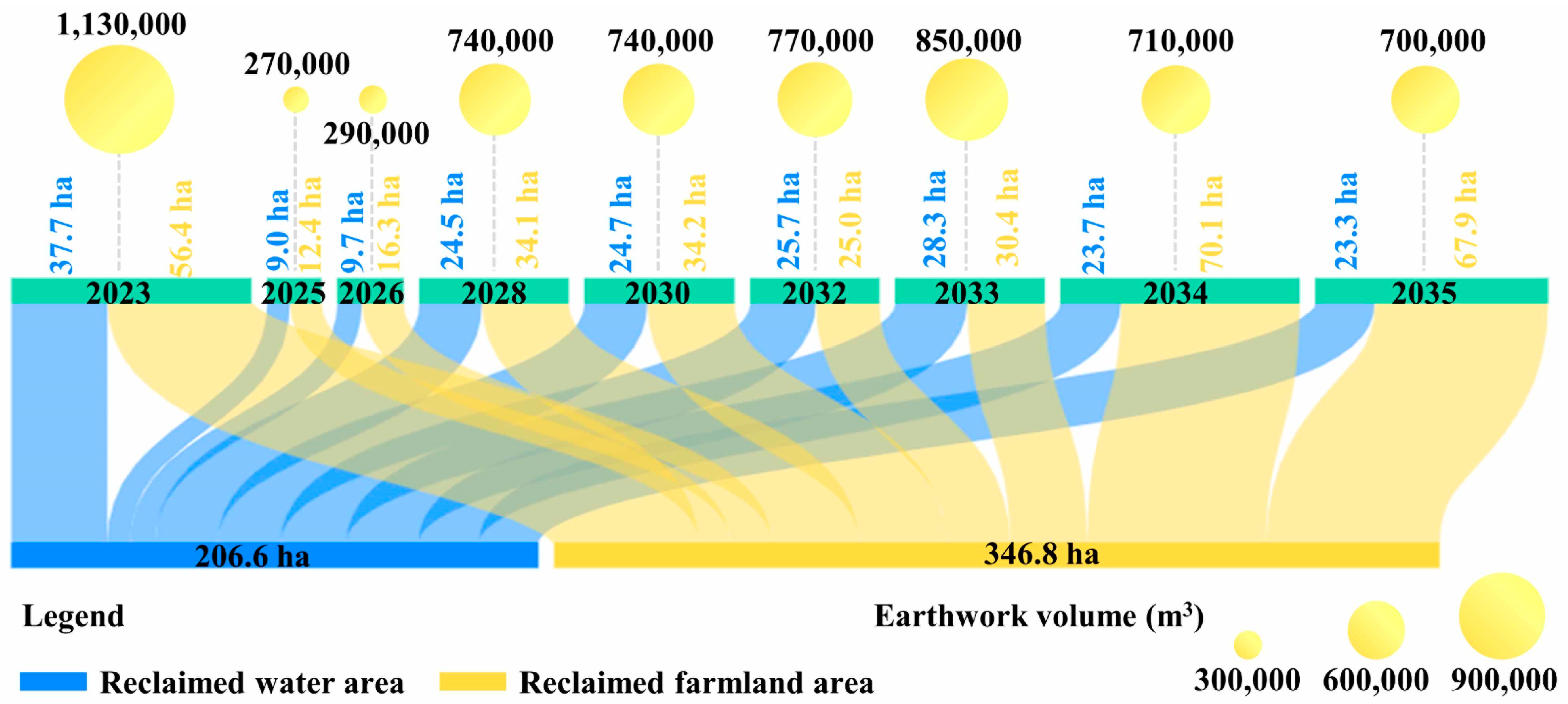
  • The spatial and temporal evolution characteristics of subsidence water area were quantified by mining subsidence prediction. By the end of the mining activities in the study area, the surface will form a subsidence water area of 1576 ha, accounting for 80% of the total subsidence area.
  • Based on the mining plan, a PIM mathematical model, and earthwork balance principle, the range, elevation, and required earthwork of terrain reconstruction in different mining stages were designed to guide the on-site construction.
  • The ecological reclamation planning and integrated management of mining subsidence land was proposed, including the fundamental approach to agroforestry reclamation and sustainable integration of subsidence waterfront and waterlogging spaces to maximize the restoration and utilization of land resources and construct a new ecological balance system.
  • The simulation results revealed that CMR can produce 6,200,000 cubic meters of soil and restore 448.4 hectares of farmland, achieving a 69% reclamation rate. Moreover, CMR can shorten the reclamation period to 9 years and extend the utilization of subsidence land.
Support and guidance for land reclamation planning in mining subsidence areas with HGT are provided by this study. The aim of this study is to decrease conflicts between land use and mining activities in CGCA while simultaneously fostering sustainable development in mining regions and endorsing the responsible utilization of land resources.

Author Contributions

Conceptualization, Z.F.; methodology, Z.F.; software, X.Z.; validation, Y.Z.; formal analysis, Z.F.; investigation, R.C.; resources, R.C.; data curation, L.L.; writing—original draft preparation, Z.F.; writing—review and editing, Z.F.; visualization, Z.F.; supervision, Z.H.; project administration, Z.H.; funding acquisition, Z.H. All authors have read and agreed to the published version of the manuscript.

Funding

This study is funded by the Jiangsu Province University Innovation Team Project (Grant number 20192036) and the Jiangsu Province University Innovation Talent Project (Grant number 20191468).

Data Availability Statement

The data are available from the corresponding author upon reasonable request.

Acknowledgments

We thank the anonymous reviewers for their constructive comments on the earlier version of the manuscript. All individuals agree to confirm.

Conflicts of Interest

The authors declare no conflict of interest.

References

  1. Zhu, Y.; Wang, Z.; Zhu, X. New Reflections on Food Security and Land Use Strategies Based on the Evolution of Chinese Dietary Patterns. Land Use Policy 2023, 126, 106520. [Google Scholar] [CrossRef]
  2. Darmody, R.G.; Bauer, R.; Barkley, D.; Clarke, S.; Hamilton, D. Agricultural Impacts of Longwall Mine Subsidence: The Experience in Illinois, USA and Queensland, Australia. Int. J. Coal Sci. Technol. 2014, 1, 207–212. [Google Scholar] [CrossRef]
  3. Blachowski, J.; Kopec, A.; Milczarek, W.; Owczarz, K. Evolution of Secondary Deformations Captured by Satellite Radar Interferometry: Case Study of an Abandoned Coal Basin in SW Poland. Sustainability 2019, 11, 884. [Google Scholar] [CrossRef]
  4. Solarski, M.; Machowski, R.; Rzetala, M.; Rzetala, M.A. Hypsometric Changes in Urban Areas Resulting from Multiple Years of Mining Activity. Sci. Rep. 2022, 12, 2982. [Google Scholar] [CrossRef]
  5. Kragt, M.E.; Manero, A. Identifying Industry Practice, Barriers, and Opportunities for Mine Rehabilitation Completion Criteria in Western Australia. J. Environ. Manag. 2021, 287, 112258. [Google Scholar] [CrossRef] [PubMed]
  6. Marschalko, M.; Bednárik, M.; Yilmaz, I.; Bouchal, T.; Kubečka, K. Evaluation of Subsidence Due to Underground Coal Mining: An Example from the Czech Republic. Bull. Eng. Geol. Environ. 2012, 71, 105–111. [Google Scholar] [CrossRef]
  7. Harnischmacher, S.; Zepp, H. Mining and Its Impact on the Earth Surface in the Ruhr District (Germany). Z. Für Geomorphol. 2014, 58, 3–22. [Google Scholar] [CrossRef]
  8. Bian, Z.; Miao, X.; Lei, S.; Chen, S.E.; Wang, W.; Struthers, S. The Challenges of Reusing Mining and Mineral-Processing Wastes. Science 2012, 337, 702–703. [Google Scholar] [CrossRef] [PubMed]
  9. Tripathi, N.; Singh, R.S.; Nathanail, C.P. Mine Spoil Acts as a Sink of Carbon Dioxide in Indian Dry Tropical Environment. Sci. Total Environ. 2014, 468–469, 1162–1171. [Google Scholar] [CrossRef] [PubMed]
  10. Petlovanyi, M.; Malashkevych, D.; Sai, K.; Stoliarska, O. Ecological-economic aspects of mining thin coal seams in the Western Donbas. J. Geol. Geogr. Geoecol. 2023, 32, 569–580. [Google Scholar] [CrossRef]
  11. Can, E.; Kuşcu, Ş.; Kartal, M.E. Effects of Mining Subsidence on Masonry Buildings in Zonguldak Hard Coal Region in Turkey. Environ. Earth Sci. 2012, 66, 2503–2518. [Google Scholar] [CrossRef]
  12. Pratiwi; Narendra, B.H.; Siregar, C.A.; Turjaman, M.; Hidayat, A.; Rachmat, H.H.; Mulyanto, B.; Suwardi; Iskandar; Maharani, R.; et al. Managing and Reforesting Degraded Post-Mining Landscape in Indonesia: A Review. Land 2021, 10, 658. [Google Scholar] [CrossRef]
  13. Jie, D.; Xu, X.; Guo, F. The Future of Coal Supply in China Based on Non-Fossil Energy Development and Carbon Price Strategies. Energy 2021, 220, 119644. [Google Scholar] [CrossRef]
  14. Lechner, A.M.; Baumgartl, T.; Matthew, P.; Glenn, V. The Impact of Underground Longwall Mining on Prime Agricultural Land: A Review and Research Agenda. Land Degrad. Dev. 2016, 27, 1650–1663. [Google Scholar] [CrossRef]
  15. Guo, W.; Zhao, G.; Lou, G.; Wang, S. A New Method of Predicting the Height of the Fractured Water-Conducting Zone Due to High-Intensity Longwall Coal Mining in China. Rock Mech. Rock Eng. 2019, 52, 2789–2802. [Google Scholar] [CrossRef]
  16. Xiao, W.; Hu, Z.; Fu, Y. Zoning of Land Reclamation in Coal Mining Area and New Progresses for the Past 10 Years. Int. J. Coal Sci. Technol. 2014, 1, 177–183. [Google Scholar] [CrossRef]
  17. Li, G.; Hu, Z.; Li, P.; Yuan, D.; Wang, W.; Yang, K. The Optimal Framework and Model to Balance Underground Coal Mining and Cropland Protection in Jining, Eastern China. Resour. Policy 2021, 74, 102307. [Google Scholar] [CrossRef]
  18. Castendyk, D.N.; Eary, L.E.; Balistrieri, L.S. Modeling and Management of Pit Lake Water Chemistry 1: Theory. Appl. Geochem. 2015, 57, 267–288. [Google Scholar] [CrossRef]
  19. Machowski, R.; Rzętała, M.A. Morpho- and Hydrogenesis of Water Bodies in Subsidence Basins as Exemplified by Water Bodies in Zabrze, Upper Silesia (Southern Poland). Z. Für Geomorphol. 2014, 58, 471–483. [Google Scholar] [CrossRef]
  20. Machowski, R. Changes in the Landform and Water Conditions of the Industri-Alized Urban Area as a Result of Mining Activities. Land 2022, 11, 1710. [Google Scholar] [CrossRef]
  21. Dhakate, R.; Modi, D.; Rao, V.V.S.G. Impact Assessment of Coal Mining on River Water and Groundwater and Its Interaction through Hydrological, Isotopic Characteristics, and Simulation Flow Modeling. Arab. J. Geosci. 2019, 12, 8. [Google Scholar] [CrossRef]
  22. Lopez, X.P.S.; Blanchette, M.L. IMWA Insight: Understanding Public Perceptions of a New Pit Lake in As Pontes, Spain. Mine Water Environ. 2020, 39, 647–656. [Google Scholar] [CrossRef]
  23. Blanchette, M.L.; Lund, M.A. Pit Lakes Are a Global Legacy of Mining: An Integrated Approach to Achieving Sustainable Ecosystems and Value for Communities. Curr. Opin. Environ. Sustain. 2016, 23, 28–34. [Google Scholar] [CrossRef]
  24. Hu, Z.; Yang, G.; Xiao, W.; Li, J.; Yang, Y.; Yu, Y. Farmland Damage and Its Impact on the Overlapped Areas of Cropland and Coal Resources in the Eastern Plains of China. Resour. Conserv. Recycl. 2014, 86, 1–8. [Google Scholar] [CrossRef]
  25. Penghui, J.; Manchun, L.; Liang, C. Dynamic Response of Agricultural Productivity to Landscape Structure Changes and Its Policy Implications of Chinese Farmland Conservation. Resour. Conserv. Recycl. 2020, 156, 104724. [Google Scholar] [CrossRef]
  26. Liu, H.; Zhang, M.; Su, L.; Chen, X.; Liu, C.; Sun, A. A Boundary Model of Terrain Reconstruction in a Coal-Mining Subsidence Waterlogged Area. Environ. Earth Sci. 2021, 80, 1–15. [Google Scholar] [CrossRef]
  27. Ranjith, P.G.; Zhao, J.; Ju, M.; De Silva, R.V.S.; Rathnaweera, T.D.; Bandara, A.K.M.S. Opportunities and Challenges in Deep Mining: A Brief Review. Engineering 2017, 3, 546–551. [Google Scholar] [CrossRef]
  28. Jing, Z.; Wang, J.; Zhu, Y.; Feng, Y. Effects of Land Subsidence Resulted from Coal Mining on Soil Nutrient Distributions in a Loess Area of China. J. Clean. Prod. 2018, 177, 350–361. [Google Scholar] [CrossRef]
  29. Chen, Q.; Hang, M. Dynamic Reclamation Methods for Subsidence Land in the Mining Area with High Underground Water Level. Open Geosci. 2018, 10, 639–646. [Google Scholar] [CrossRef]
  30. Hu, Z.; Xiao, W. Optimization of Concurrent Mining and Reclamation Plans for Single Coal Seam: A Case Study in Northern Anhui, China. Environ. Earth Sci. 2013, 68, 1247–1254. [Google Scholar] [CrossRef]
  31. Jiang, Y.; Misa, R.; Tajduś, K.; Sroka, A.; Jiang, Y. A New Prediction Model of Surface Subsidence with Cauchy Distribution in the Coal Mine of Thick Topsoil Condition. Arch. Min. Sci. 2020, 65, 147–158. [Google Scholar] [CrossRef]
  32. Wang, L.; Wei, T.; Li, N.; Chi, S.; Jiang, C.; Fang, S. Research on Probability Integration Parameter Inversion of Mining-Induced Surface Subsidence Based on Quantum Annealing. Environ. Earth Sci. 2018, 77, 740. [Google Scholar] [CrossRef]
  33. Sepehri, M.; Apel, D.B.; Hall, R.A. Prediction of Mining-Induced Surface Subsidence and Ground Movements at a Canadian Diamond Mine Using an Elastoplastic Finite Element Model. Int. J. Rock Mech. Min. Sci. 2017, 100, 73–82. [Google Scholar] [CrossRef]
  34. Blachowski, J. Application of GIS Spatial Regression Methods in Assessment of Land Subsidence in Complicated Mining Conditions: Case Study of the Walbrzych Coal Mine (SW Poland). Nat. Hazards 2016, 84, 997–1014. [Google Scholar] [CrossRef]
  35. Akcin, H.; Kutoglu, H.S.; Kemaldere, H.; Deguchi, T.; Koksal, E. Monitoring Subsidence Effects in the Urban Area of Zonguldak Hardcoal Basin of Turkey by InSAR-GIS Integration. Nat. Hazards Earth Syst. Sci. 2010, 10, 1807–1814. [Google Scholar] [CrossRef]
  36. Zhang, Y.; Du, L.; Liu, J. Identifying the Reuse Patterns of Coal Mining Subsidence Areas: A Case-Study of Jixi City (China). Land Degrad. Dev. 2021, 32, 4858–4870. [Google Scholar] [CrossRef]
  37. Hendrychová, M.; Svobodova, K.; Kabrna, M. Mine Reclamation Planning and Management: Integrating Natural Habitats into Post-Mining Land Use. Resour. Policy 2020, 69, 101882. [Google Scholar] [CrossRef]
  38. Mei, Z.; Bazai, N.A.; Xueling, L.; Mengnan, H.; Mohammad, T.; Ming, L.; Hui, W. Research on Wetland Ecological Restoration of Coal Mining Subsidence Area in Suzhou, China. Fresenius Environ. Bull. 2017, 26, 5177–5183. [Google Scholar]
  39. Chugh, Y.P. Concurrent Mining and Reclamation for Underground Coal Mining Subsidence Impacts in China. Int. J. Coal Sci. Technol. 2018, 5, 18–35. [Google Scholar] [CrossRef]
  40. Kabwe, E. Mining Sequence Deformation and Failure Behaviour Analysis in the Hangingwall and Orebody Rock Formations; A Continuum Approach. Geotech. Geol. Eng. 2017, 35, 1453–1473. [Google Scholar] [CrossRef]
  41. Zhu, X.; Guo, G.; Liu, H.; Yang, X. Surface Subsidence Prediction Method of Backfill-Strip Mining in Coal Mining. Bull. Eng. Geol. Environ. 2019, 78, 6235–6248. [Google Scholar] [CrossRef]
  42. Yin, H.; Guo, G.; Li, H.; Wu, Z. An Intelligent Optimization Design Method of the Compressed Ratio of Backfilling Body to Avoid Backfilling Mining-Induced Environmental Damage. Environ. Sci. Pollut. Res. 2022, 29, 69022–69036. [Google Scholar] [CrossRef] [PubMed]
Figure 1. (a) Schematic diagram of mining subsidence and ponding; (b) Soil profile in the study area.
Land 12 01994 g001
Figure 2. Location of the study area: (a) The distribution of CGCA in eastern China.; (b) The surface status and mining plan of the study area.
Land 12 01994 g002
Figure 3. Flow chart of CMR in the mining subsidence area with HGT.
Land 12 01994 g003
Figure 4. Spatio-temporal evolution of mining subsidence and surface ponding from 2023 to 2035.
Land 12 01994 g004
Figure 5. Statistics on the area of farmland with different degrees of degradation.
Land 12 01994 g005
Figure 6. Phased Reclamation Planning: (a) Phased earthwork allocation scheme; (b) Filling thickness and elevation of backfill area.
Land 12 01994 g006
Figure 7. Statistics on the area of phased reclaimed water, agricultural land, and phased available earthworks.
Land 12 01994 g007
Figure 8. Land use change in the study area under different development scenarios: (a) NR; (b) PMR; (c) CMR; (d) Comparison of reclamation efficiency.
Land 12 01994 g008
Figure 9. Reclamation and ecological restoration strategies for coal mining subsidence areas with comprehensive governance modes.
Land 12 01994 g009
Table 1. Classification criteria for land degradation degree.
Degradation DegreeSubsidence ValueDescription
Light<0.5 mThe impact on land management is small, with little surface deformation.
Moderate0.5 m–1.5 mSeasonal ponding can have a major impact on agriculture during the flood season.
Severe>1.5 mThe surface forms perennial water and completely loses the ability of cultivation.
Disclaimer/Publisher’s Note: The statements, opinions and data contained in all publications are solely those of the individual author(s) and contributor(s) and not of MDPI and/or the editor(s). MDPI and/or the editor(s) disclaim responsibility for any injury to people or property resulting from any ideas, methods, instructions or products referred to in the content.

