Abstract
Spatial planning is broadly acknowledged for its pivotal role in local climate change adaptation. Nevertheless, variations persist among countries in their perceptions and practices concerning the effectiveness and feasibility of utilizing spatial planning for climate change adaptation. Chinese cities confront the challenges of global warming, rapid urbanization, and intensified extreme weather events. Climate change adaptation agreements, frameworks, and policies have predominantly emphasized the national scale, often overlooking local adaptation efforts. However, the ongoing reform and restructuring of China’s territorial and spatial planning system encompasses the categorization, hierarchical management, control of comprehensive national land resource development, and conservation. This process is gradually establishing spatial planning strategies that synergize with the impacts of climate change, thereby offering an opportunity to integrate climate change adaptation objectives into spatial planning. This endeavor is supported by a series of regulatory standards and guidelines to ensure its effective implementation. The study scrutinizes the public draft of territorial and spatial master plans for 368 Chinese cities to assess the integration of climate change concerns at the local level and to identify disparities among cities. Employing the Awareness, Analysis, and Action Framework (3A Framework), which draws from prior scholarship and integrates relevant existing research, we identified and assessed 30 criteria for recognizing and appraising climate change adaptation strategies in territorial and spatial planning. The study’s findings indicate that: (1) The role of territorial and spatial planning in integrating climate change issues at the city level requires enhancement, as reflected in the generally low “awareness” of climate change concerns, limited “analytical capacity” regarding climate change, and a certain foundation for “action response” to climate change adaptation; (2) Large cities, characterized by robust economies and population concentrations, generally outperform small and medium-sized cities. They exhibit a superior ability to delineate quantifiable climate adaptation indicators and measures. In conclusion, the study provides prospective recommendations concerning technical approaches, spatial governance, mechanisms, and actions to more effectively incorporate climate change adaptation objectives into local-level territorial and spatial planning.
1. Introduction
Addressing climate change necessitates tailored responses at various spatial scales [1,2], with the potential for climate action at the city level often significantly underestimated when compared to global and national policy responses [3]. The Intergovernmental Panel on Climate Change (IPCC) in its Fifth Assessment Report identifies cities as primary areas at risk from climate change [4], underscoring the growing significance of climate change research within urban contexts. International literature has likewise substantiated the critical role of cities in climate change mitigation and adaptation efforts [5,6,7].
Urban-scale research has increasingly focused on studies pertaining to urban spatial planning that incorporate climate considerations. Spatial planning is progressively acknowledged as a mechanism and tool for both mitigating and adapting to climate change [8,9]. It can effectively integrate urban spatial layout, optimize spatial form, and strategically manage land use and infrastructure layout [10,11]. The interaction among these elements constitutes the primary driver of climate change across all scales [12]. Furthermore, addressing the uncertainty associated with climate change necessitates a transformation in spatial planning regarding its objectives, content, and methods. Spatial planning objectives must place greater emphasis on the dynamic coordination of economic and societal development with resource and environmental considerations [13]. The content of spatial planning should highlight the assessment of climate change impacts [14] and integrate climate adaptation themes and tasks across different spatial scales [15]. It should also enhance the utilization of planning methods such as scenario planning, dynamic iterative adjustments, and community engagement [16,17,18]. Simultaneously, spatial planning holds the potential to serve as an effective governance instrument for addressing climate change at the local level through its influence on policy measures for spatial development [19,20,21].
In Western nations, the incorporation of climate change adaptation objectives into spatial planning has evolved into a mainstream policy. For instance, in the United Kingdom, urban planning has been recognized as a crucial strategic tool in addressing climate change. This recognition has led to the enhancement of planning systems at the national, regional, and local levels. It involves strengthening specialized climate adaptation analyses within urban planning, the integration of spatial research and adaptation strategies, and the incorporation of tools such as strategic environmental assessments, sustainable assessments, and climate impact analyses [22]. In the United States, a precise approach involves setting practical climate goals through comprehensive climate assessments. This approach explores long-term, actionable climate adaptation actions and promotes coordinated efforts through multi-stakeholder collaboration [23]. Germany has initiated climate adaptation efforts by starting with the construction of regional climate models. This approach has led to the implementation of climate-resilient regional planning and urban planning practices. These practices encompass initiatives such as reducing vehicular transportation, promoting public and pedestrian-friendly transportation options, advocating for land-efficient residential area structures, facilitating functional layouts conducive to climate protection, and promoting sustainable land-use choices. This has also driven the adoption of green urban renewal models [24,25]. Conversely, in developing countries and economies that have developed later, the potential of spatial planning in climate change adaptation remains unrealized. This can be attributed to the lag in the modernization of their urban planning in comparison to Western nations, compounded by an insufficient system of planning regulations and policies [20,26].
For several decades, China has been considered one of the regions that are most susceptible to climate change, and the repercussions of climate change present substantial challenges to urban areas [27]. China has a rich history of engagement in climate programs and agreements, with endeavors to combat climate change dating as far back as the late 1980s. Furthermore, it has systematically developed a planning framework for climate change adaptation since the early 21st century. Nevertheless, China has long grappled with the absence of a prevailing standard in the realm of climate change and spatial planning research. The recent reform of territorial and spatial planning has comprehensively coordinated the planning entities, planning content, technical standards, and implementation mechanisms pertaining to various spatial elements. It has aimed to establish a systematic management and control framework for the rational development and protection of territorial resources on a regional scale. This reform has bolstered the policy orientation and synergistic effects of spatial planning, enabling effective responses to urban security issues stemming from climate-related disasters. Simultaneously, the National Climate Change Adaptation Strategy 2035 advocates for the integration of climate change adaptation within territorial and spatial planning. It also envisions the creation of a multi-tiered regional framework for climate change adaptation.
To prepare cities for the adverse impacts of climate change, local authorities must improve their adaptive capacity [28]. Moser and Luers (2008) delineated three pivotal dimensions that warrant heightened emphasis in assessing how California resource managers prepare for the risks associated with ongoing climate change. These dimensions encompass: awareness of climate-related risks, analytical capabilities to translate these climate risk insights into concrete planning and management activities, and the extent of actions undertaken to mitigate these risks. Awareness, analysis, and action constitute the three critical dimensions that decision-makers must bolster to establish and implement the capacity for climate change adaptation and mitigation [28]. Meanwhile, because territorial and spatial planning represents a relatively novel planning system, research on how Chinese cities engage with climate change within the realm of local spatial planning remains limited.
Employing the 3A analytical framework, this study performed a textual analysis of territorial and spatial master plans from 368 cities and regions nationwide. This analysis incorporated 30 revised criteria and sought to provide a critical assessment of the integration of climate change adaptation considerations into territorial and spatial planning. The aim is to fill this void by addressing two core research inquiries: (1) To what extent can Chinese cities proficiently incorporate climate change considerations into their territorial and spatial planning, and what strategies are most effective in doing so? (2) What are the discernible distinctions in territorial and spatial planning between cities of varying types and sizes, what factors primarily contribute to these distinctions, and how can they be ameliorated? The outcomes of this examination can serve as valuable references for other cities across China as they embark on the endeavor of formulating and enhancing their territorial and spatial planning to better accommodate the challenges of climate change. The study will also assist local governments in identifying critical areas that require innovative response measures to enhance future planning practices.
The subsequent sections of the paper are structured as follows: Section 2 reviews the evolution of climate change policies and initiatives in China, outlines the composition of China’s territorial and spatial planning system, and provides an overview of research progress in climate change adaptation within spatial planning in China. In Section 3, we elaborate on the study’s methodology, encompassing the establishment of the evaluation framework, definition of evaluation criteria, case sample selection guidelines, and data analysis procedures. Section 4 delves into the comprehensive and partial evaluation outcomes. Section 5 engages in a discussion of the study’s key findings. Lastly, Section 6 offers a summary of the research, highlighting its limitations and presenting future perspectives.
2. Development Context and Research Progress Regarding China’s Climate Change Response and Territorial and Spatial Planning
2.1. Strategic Measures and Policy Responses to Climate Change in China
Due to its diverse climate patterns, China holds a pivotal role as both a highly sensitive region and a prominent influencer within the realm of global climate change. In 2002, the Ministry of Science and Technology (MOST) spearheaded the initiation of a nationwide climate change assessment initiative, culminating in the subsequent release of four national assessment reports on climate change [29]. The most recent report indicates that, in the context of global warming, China is experiencing a notable upward trend in near-surface temperatures, a general increase in annual precipitation, coastal sea level rise exceeding the global average for the same timeframe, and climate change posing varying degrees of threats to food security, ecological security, national security, and water resource security [30].
China’s strategies, actions, and mechanisms for climate adaptation primarily commenced in the early 21st century. In 2007, the National Leading Group on Climate Change, Energy Conservation, and Emission Reduction was established. In that same year, the National Development and Reform Commission (NDRC) released China’s inaugural National Climate Change Programme. This program advocated the integration of climate change considerations into both the overarching national economic and social development plans and regional planning. It also outlined specific directives for greenhouse gas (GHG) emissions control, bolstering adaptive capacity to climate change, leveraging scientific and technological advancements and innovation, and enhancing institutional frameworks [31]. Subsequently, provincial development and reform departments formulated localized climate change mitigation plans. Although China has a lengthy history of engagement in climate programs and agreements, it did not establish explicit climate change goals until the 12th Five-Year Plan [32].
Since 2013, China has significantly accelerated the development and issuance of climate change adaptation strategies and plans. Notably, these include the release of the National Climate Change Adaptation Strategy [33], the National Plan for Addressing Climate Change (2014–2020) [34], as well as action plans dedicated to climate change adaptation within urban and forestry sectors. The government also announced the initiation of the first phase of climate-adapted city construction involving 28 cities or regions [35]. Concurrently, building on implementation outcomes and accumulated experience, China introduced the National Climate Change Adaptation Strategy 2035 (NCCAS 2035), characterized by enhanced detail and operational precision compared to previous adaptation plans. This comprehensive strategy was publicly unveiled [36], along with a notice outlining the expansion of a new series of pilot projects focused on climate-adapted city construction [37]. These pivotal documents and actions mark the culmination of policy formulation and demonstration efforts, progressing from the central government to departmental levels and subsequently to local authorities. This concerted effort has not only fostered strategic guidance for climate change adaptation in key areas and regions, but also laid the foundation for China’s nascent policy framework dedicated to climate change adaptation.
2.2. The Formation and Attributes of the Territorial and Spatial Planning System
Historically, China’s spatial planning encompassed a range of categories, including main functional area planning overseen by the Department of Development and Reform, urban and rural planning managed by the Department of Urban and Rural Planning, land and land use planning administered by the Department of Land and Resources, ecological environment protection planning under the jurisdiction of the Department of Ecological Environment, and marine function zoning supervised by the Department of Marine Affairs, among others. These various planning types at different administrative levels have given rise to corresponding spatial planning systems, each designed to fulfill specific functions and regulations. They have collectively played a constructive role in facilitating the organized growth of urban and rural regions and promoting the judicious use of space (Figure 1). However, the proliferation of spatial planning categories has resulted in a lack of coherence between plans, leading to fragmentation and substantial overlap among planning departments. Furthermore, local authorities frequently engage in unregulated modifications to planning, significantly impeding the efficiency of spatial governance and the overall quality of development outcomes [38].
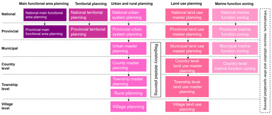
Figure 1.
Current principal spatial planning in China.
In pursuit of this objective, China has undergone a pragmatic endeavor aimed at amalgamating urban and rural planning with land use planning into a unified plan. This endeavor has also sought to merge national economic and social development planning with the aforementioned plans, despite their inherent contradictions and disparities. Additionally, the effort has extended to the integration of national economic and social development planning, urban and rural planning, land use planning, ecological environmental protection planning, and various other planning components into a single comprehensive plan [39]. Progress has been achieved in mitigating spatial control conflicts, streamlining the approval processes, and optimizing the spatial configuration of urban and rural areas. However, despite these accomplishments in technical coordination, the enduring conflicts embedded within the planning system remain unresolved [40,41,42].
Since late 2012, China has intensified its efforts to reform and institutionalize the spatial domain. In 2013, the proposal for establishing a spatial planning system and reforming the planning system was first introduced [43]. Grounded in the reform of the ecological civilization system, the emphasis shifted toward constructing a spatial planning system centered on spatial governance and the optimization of spatial structures. This system aimed for national cohesion, connectivity, hierarchical management, and the realization of the “one plan and one blueprint for one city and county” objective [44]. This endeavor also became a pivotal means for China to resolve the conflicts arising from multiple regulations and to advance the modernization of its national governance system and capacity. Initiated with top-level design, China executed institutional reform of the planning system and established the Ministry of Natural Resources, taking the lead in instituting the territorial and spatial planning system and overseeing its implementation [45]. This initiative provided organizational context and institutional assurance for the actualization of genuine “multiple planning into one.” In 2019, China advocated the integration of spatial planning—including main functional area planning, land use planning, and urban and rural planning—into a unified territorial and spatial planning system. This highlighted that territorial and spatial planning serves as the comprehensive blueprint guiding and regulating territorial space development and utilization. Furthermore, it elucidated the overarching framework of “five levels and three categories” within territorial and spatial planning [46] (Figure 2). Within this framework, master planning encapsulates the strategic objectives formulated by local governments at all levels [47] and constitutes the cornerstone of the national territorial and spatial planning system. Detailed planning is interpreted as the implementation arrangements for specific land use, development, and construction intensity. Meanwhile, specialized planning pertains to the spatial layout for development, conservation, and utilization in specific regions and sectors to delineate specific functions [46].
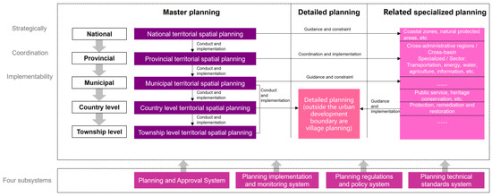
Figure 2.
China’s territorial and spatial planning system: The “Five Levels, Three Categories, and Four Subsystems”.
2.3. Research Advancements in Climate Change Adaptation of Spatial Planning in China
The emergence of numerous climate change-related adaptation agreements, frameworks, and policies at both national and local levels, coupled with the progressive implementation of actions and measures at the local level, has brought climate change spatial governance to the forefront. This has prompted in-depth discussions among Chinese scholars regarding strategies for bolstering urban resilience to climate change through spatial planning. For instance, in regard to planning content, recommendations have been made to integrate climate change adaptation and risk management into urban planning. Additionally, scholars have put forth proposals for establishing a planning research framework and prioritizing key concerns related to climate change mitigation and adaptation [48,49,50,51]. Moreover, they have explored the integration of climate change adaptation into the technological and decision-making facets of spatial planning, adopting a technical methodology perspective [52,53]. In terms of planning execution, recommendations have emerged to enhance the assessment of spatial planning’s impact on the climate environment [54,55].
Nonetheless, traditional spatial planning has historically been guided by urban spatial expansion, economic growth, and population increase, assuming static resource and environmental conditions. It has advocated for well-defined urban spatial structures, functional arrangements, and industrial compositions. Consequently, it has to some extent overlooked the influence of climate change factors and environmental disaster risks on planning [47]. In the planning process, including aspects such as planning objectives, preparation contents, and implementation oversight, there is a notable absence of consideration for climate change adaptation. For instance, some criteria in infrastructure planning and design acknowledge the need to consider climate change impacts; however, they do not specify the requisite adjustments required to address climate change, nor do they elucidate the methodology for determining these adjustments [56]. Concurrently, traditional climate change adaptation efforts tend to concentrate on urban spaces, neglecting opportunities for adaptation actions within ecological and agricultural domains [57,58]. In summary, China’s endeavors in spatial planning for climate change adaptation confront a host of issues and challenges, including deficient climate adaptation objectives and concepts, discrepancies between climate change risk assessment and spatial planning scales, absence of synergistic mechanisms bridging adaptation and mitigation strategies, and deficiencies in technical standards, legal frameworks, and regulations [59].
The reform of China’s territorial and spatial planning system has established a unified land-use control regime by comprehensively considering factors such as population distribution, economic layout, land utilization, and ecological environmental protection. This has resolved conflicts and contradictions that previously existed among various spatial planning categories. It presents a significant opportunity for integrating climate change adaptation into the planning process, with support provided through a series of regulations and guidelines. This encompasses the establishment of different levels of indicators related to disaster prevention, disaster reduction, and urban resilience in urban health examinations [60]. Furthermore, the guidelines for the development of territorial and spatial planning at the provincial and municipal levels play a crucial role in reinforcing the incorporation of climate adaptation measures. Key components of this integration encompass the prioritization of disaster risk assessment, the amalgamation of climate change considerations with other trends, the study and identification of territorial space development requirements, and the conduct of scenario simulation analyses. Additionally, the protection areas and measures for various types of ecological spaces—characterized by their natural attributes and primarily intended for providing ecological services or products—are being implemented. Simultaneously, within the scope of ecological spaces, regions such as land, water, and sea areas possessing critically important ecological functions that require mandatory and rigorous protection are designated as ecological conservation redlines. A harmonization effort is made between the ecological conservation redlines, permanently designated essential farmland, and urban development boundaries, ensuring that boundaries do not overlap, spaces do not intersect, and functions remain non-conflicting. In terms of specific mitigation measures, requirements for the layout of blue-green spaces and ecological corridors are proposed, along with the establishment standards for disaster prevention and mitigation facilities. Moreover, it actively encourages the development of “sponge cities” and reinforces disaster response measures in coastal cities, particularly in addressing sea-level rise resulting from climate change [61,62].
In the realm of theoretical exploration, Chinese scholars have initiated comprehensive investigations, delving into adaptation concepts and ideas [59,63], methodologies and strategies [64,65], governance systems [29,66], and local practices [67]. Their collective efforts aim to chart the overarching principles and detailed strategies of a framework system for territorial and spatial planning informed by the imperatives of climate change.
3. Methodology
3.1. Developing the Review Framework
Drawing upon studies of planning and policies in select countries, some scholars have incrementally addressed the integration of climate change into various policy agendas by proposing diverse analytical and assessment frameworks [26,68]. International and national research organizations have also introduced a range of frameworks widely applied across different spatial scales. For instance, the International Institute for Environment and Development (IIED) has developed a coherent climate change adaptation planning framework, encompassing potential indicators or indicator categories for tracking and evaluating the success of adaptation support and interventions [69]. The United Nations Development Programme (UNDP) and the United Nations International Strategy for Disaster Reduction (UNISDR) have independently introduced an Adaptation Policy Framework (APF) from the perspective of enhancing climate adaptation planning and policies, as well as bolstering urban resilience. They have also provided guidelines targeting city and local leaders, encompassing ten disaster resilience elements [70,71]. These assessment frameworks are predominantly outcome or sector-oriented [72], and are employed to comprehend critical gaps and issues related to climate change [1,19,68]. These frameworks’ experiences were adapted and served as a reference in the development of the review framework for this study, which centers on the processes and potential outcomes of future spatial plans.
Moser and Luers (2008) [28] identify three primary components for enhancing adaptive capacity in addressing climate change issues: awareness, analysis, and action (commonly referred to as the 3A framework). Adapting to climate change necessitates policymakers to grasp the associated risks [28], conduct comprehensive analyses of these risks and their impacts [72], and translate this awareness and risk assessment into tangible actions and planning initiatives [26,72]. Therefore, this study will employ the 3A framework to assess how Chinese cities adapt to climate change in the context of local spatial planning.
3.2. Scoring Territorial and Spatial Plans against the Evaluation Criteria
To employ the 3A framework for reviewing spatial plans in China, it is necessary to establish criteria for each component that encompass the various activities typically encountered in the spatial planning process. Hence, this study modifies the existing framework and criteria based on insights from climate change literature and an initial analysis of territorial and spatial planning. This adaptation ensures alignment with territorial and spatial planning policies, resulting in the identification of 30 criteria: 3 for awareness, 6 for analysis, and 21 for action (Table 1). The number of criteria varies within the three components due to their varying relevance and interdependence. The scoring system employed in this study follows the methodology proposed by Hurlimann et al. (2021) [73] and Kumar and Geneletti (2015) [26]. Criteria typically received a score of 0 if they were absent from the spatial planning document. A score of 1 was assigned if a criterion was mentioned in the spatial planning without accompanying quantitative indicators or detailed explanations. A score of 2 was assigned when the criterion was integrated into the spatial planning with specific measurable indicators.

Table 1.
The review framework developed for this study.
3.3. Selection of the Sample of Territorial and Spatial Planning
Territorial and spatial master planning represents the highest-level spatial strategy for a region or city, serving as the foundational policy and comprehensive framework governing the protection, development, utilization, and restoration of territorial space throughout the entire region [46]. These plans can function as crucial policy documents that encapsulate the developmental aspirations of local governments, offering an ideal platform for the examination and evaluation of how climate change considerations are integrated into spatial planning. As of July 2023, a total of 33 provincial-level plans (excluding Taiwan Province) and 362 municipal-level plans (except for Suihua City in Heilongjiang Province and Sansha City in Hainan Province, which have not yet been announced) for territorial and spatial master planning have been made publicly available [87]. In this study, we have selected 362 cities and regions across China, all of which have fully disclosed their plans, along with 4 municipalities directly under the Central Government and 2 special administrative regions, to conduct a comprehensive analysis of the territorial and spatial master planning drafts (Figure 3).
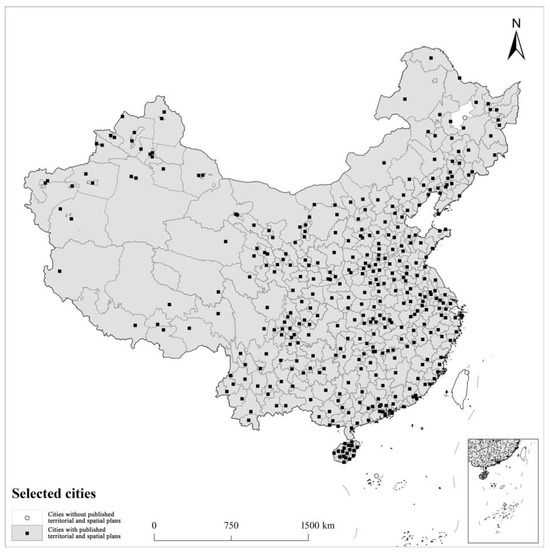
Figure 3.
The geographic distribution map depicts the locations of the 368 Chinese cities selected for this study.
The primary timeframe for this research project spans from August to September 2023. All territorial and spatial planning public disclosure documents were downloaded from early August to mid-August, followed by the assessment and statistical analysis of all territorial and spatial planning activities from mid-August to late August. It is important to note that owing to disparities in information disclosure and the varying stages of planning across different cities, this study will focus exclusively on the analysis of publicly accessible documents related to territorial and spatial master planning. These documents are readily available online via the websites of local governments or natural resource departments.
3.4. Data Analysis
The data analysis proceeded through three stages. In the initial stage, we evaluated the overall performance of the 368 territorial and spatial plans against the set of 30 criteria by summing the original scores without standardization within the review framework. Subsequently, the second stage delved into assessing the integration level of climate change components within territorial and spatial plans. The sum of the original scores for each component was standardized on a 0–1 scale. Descriptive statistics were then used to assess the performance and interrelationship among the components. In the third stage, the performance of each criterion in all the territorial and spatial plans was evaluated using the performance analysis.
The criterion performance analysis method is based on the evaluation research referenced from Tang et al. (2010) [72] regarding the U.S. Local Climate Action Plan. Criterion performance is assessed across two dimensions: horizontal breadth scores and vertical depth scores, depending on the characteristics of their impact. Criterion breadth measures the extent to which each criterion is addressed across all plans, and is defined as the proportion of territorial and spatial planning involving that criterion (Equation (1)). Criterion depth measures the importance and analyzes the extent to which each criterion is addressed within territorial and spatial planning (Equation (2)). The formulas are normalized percentages, providing a consistent basis for standardized comparisons, revealing the performance characteristics of criteria across different dimensions, and allowing for quantitative differentiation within and between criteria. If none of the territorial and spatial plans involve a specific criterion, the criterion depth score is 0. If at least one territorial and spatial plan addresses a criterion, the criterion depth score falls between 50% and 100%.
Equations (1) and (2) represent the criterion breadth score and a depth score of jth criterion on the scale of 0–100%. Pj is the number of planning that addresses the jth criterion. N is the total number of spatial planning documents in the study, and Ij is the jth criterion receiving scores on the scale of 0–2.
When calculating the breadth score for a specific criterion, denoted as j, the number of spatial plans involving this criterion (with a non-zero score) is represented as Pj out of a total of N spatial plans, which equals 368. The is obtained by dividing Pj by N. To calculate the depth score for criterion j, the average scores of all spatial plans related to this standard are computed and then summed to derive .
Each urban spatial plan included as an analysis sample influences the overall performance of the criteria. Notably, criteria may not exhibit uniform performance levels, and the relationship between the depth and breadth of the same criterion may display elements of randomness and probability. For instance, while cities where the same criterion is effective tend to receive higher scores, the number of cities involved may be limited, suggesting that the criterion possesses greater depth but less breadth. Analyzing breadth and depth percentage scores provides a suitable method for assessing both the relevance and extent of participation in spatial planning. This approach allows for further quantification and comparison of the overall performance differences among different criteria in spatial planning, addressing the limitations of descriptive statistical analysis in deeper data exploration and inference.
4. Results
4.1. Overall Performance of Territorial and Spatial Planning
Following the adopted evaluation framework, the overall performance of territorial and spatial planning is quantified on a scale ranging from 0 to 60. This scale results from the fact that each of the 30 criteria can attain a maximum score of two, summing up to a potential total of 60 for each territorial and spatial plan. Utilizing natural breaks taxonomy for classification visualization minimizes variance within each category to emphasize intra-category similarities and maximizes variance across categories to highlight inter-category differences. Figure 4 visually represents the absence of comprehensive coverage for all criteria across territorial and spatial planning. An observation across all the assessed territorial and spatial plans reveals that merely 1.6% falls within the score range of 31 to 45, while a significant 73.4% falls between 16 and 30, and the remaining 25% score falls between 1 and 15. Descriptive statistics (Figure 4) illustrate that the total mean score for overall territorial and spatial planning performance is 18.68. The scores for individual territorial and spatial plans range from a maximum of 43 to a minimum of 6. Figure 5 displays the spatial distribution of scores for each city.
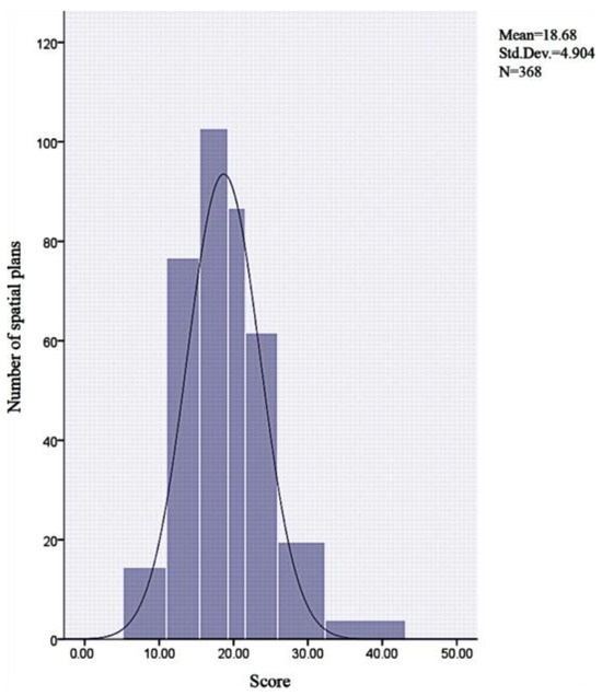
Figure 4.
Frequency distribution of evaluation scores for individual territorial and spatial plans.
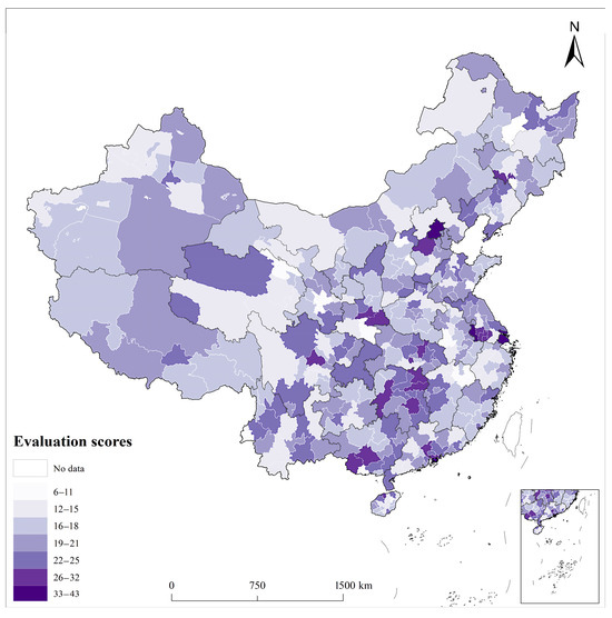
Figure 5.
Spatial distribution of evaluation scores for individual territorial and spatial plans.
4.2. Performance by Components
Figure 6 illustrates that merely seven territorial and spatial plans exhibit substantial awareness of climate change issues (representing over half of the total component score, approximately 1.9% of territorial and spatial planning). Furthermore, only one territorial and spatial plan includes pertinent analysis of climate change concerns. In contrast, 59 territorial and spatial plans exhibit a well-defined response to climate change issues across different Chinese cities (scoring more than half of the total component score, roughly 16.037% of territorial and spatial planning). Table 2 displays that the mean score for the awareness component was 0.21, the analysis component was 0.01, and the action component was 0.31. This indicates a notably low level of awareness and analysis concerning climate change across all territorial and spatial planning. During the assessment of territorial and spatial planning, the action component of the review framework exhibited stronger performance compared to the awareness and analysis components. Additionally, Table 3 presents the correlation among the three components and reveals a significant correlation between the analysis and action components (p < 0.01).
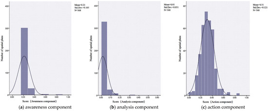
Figure 6.
Performance of territorial and spatial planning by components.
Table 2.
Descriptive statistics of the overall performance of territorial and spatial planning under the different components. Scores of each component have been normalized between zero and one.
Table 3.
Correlation matrix for the three components of climate change.
4.3. Performance by the Criterion under Each Component
4.3.1. Criteria Performance of Awareness Components in Territorial and Spatial Planning
Figure 7 clearly illustrates that a limited number of cities in China exhibit awareness of climate change issues (with scores of 10.33% for breadth and 53.95% for depth) and its impact on local environmental vulnerability (scoring at 2.99% for breadth and 50.00% for depth). However, the vast majority of cities have introduced adaptive implementation measures and established specific standards (achieving full scores of 100.00% for breadth and 95.38% for depth). While Tang et al. (2010) [72] contend that insufficient policy awareness of climate change issues is often a primary factor contributing to the subpar performance of the analysis and action components, it is noteworthy that China’s reform of territorial and spatial planning prioritizes optimizing territorial and spatial development, resource allocation efficiency, and the realization of a green and sustainable economy and society. Consequently, all cities have put forth systematic controls and guidance for production, living, and ecological spaces. These measures have addressed climate change to some extent, resulting in commendable breadth and depth scores.
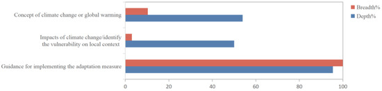
Figure 7.
Criteria performance of the awareness component of territorial and spatial planning.
4.3.2. Criteria Performance for Analysis Components in Territorial and Spatial Planning
The study reveals that within the analysis component, the vast majority of territorial and spatial plans of cities fail to address vulnerability or provide assessments regarding the physical development, transportation systems, water and sanitation infrastructure, employment and livelihood structures, organizational capacities, and political support necessary for effective climate change response. Overall, nearly all public documents related to territorial and spatial planning lack a comprehensive evaluation of their planning areas. While some assessments are considered during the decision-making process, these evaluations primarily focus on the current state of territorial development and conservation, emphasizing indicators related to bottom-line control, structural efficiency, and quality of life. However, they often lack specific requirements for climate change adaptation. Figure 8 illustrates the breadth and depth scores for each criterion within the analysis section.
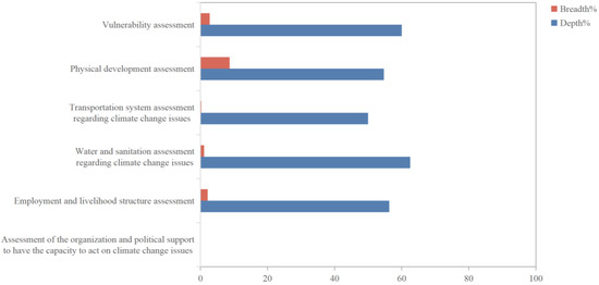
Figure 8.
Criteria performance of analysis component of territorial and spatial planning.
4.3.3. Criteria Performance of Action Components in Territorial and Spatial Planning
The action component comprises a blend of policies, tools, and responsive measures. Climate change action criteria encompass six key facets: the built environment, land use and development control, transportation, public services and facilities, green infrastructures, disaster resilience and mitigation, as well as monitoring and evaluation. However, certain response actions like those pertaining to the built environment, energy, and monitoring and evaluation have not received the requisite focus in the majority of territorial and spatial planning endeavors. Figure 9 illustrates the breadth and depth scores for the diverse criteria within the action component.
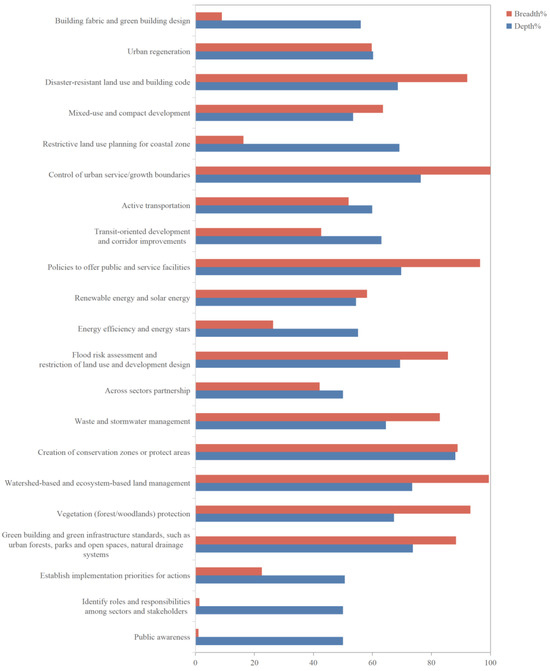
Figure 9.
Criteria performance of the action component of territorial and spatial planning.
4.3.4. Performance of cities across China
The study reveals that—with the exception of a small number of mega cities, super cities, and large cities1—the majority of cities in China are ill-prepared for climate change adaptation within the policy framework of territorial and spatial planning. Approximately 97% of the 368 assessed cities achieved scores below 30, signifying that they performed inadequately integrating climate change considerations into their territorial and spatial planning endeavors. As mentioned earlier, while a subset of these cities has indirecently undertaken actions related to climate change, their overall performance is hindered by a lack of awareness regarding climate change theory. Merely 3% of the cities attained scores exceeding 30, primarily encompassing the three facets. These findings underscore that the current territorial and spatial planning of most Chinese cities falls short in identifying climate change challenges and implementing effective address strategies (Table A1).
Moreover, within the top 100 and top 30 cities based on total scores, mega cities, super cities, and large cities collectively represent approximately 41% and 60%, respectively (Figure 10). Two factors, urban population and economic aggregate, were chosen for correlation analysis with the scores of each city. The selection of these factors was based on variable type and normality test results, and the K-S test outcomes were utilized due to the sample size. The results indicated a significance level (Sig) of less than 0.05, signifying a non-normal distribution, and led to the adoption of Spearman rank correlation analysis. The findings demonstrated a significant positive correlation between city scores and the factors of urban population and economic aggregate (p < 0.01) (Table 4). Additionally, a normal distribution analysis was employed to estimate the probability density of city scores concerning varying population sizes and economic aggregates. The probability density of the vertical axis indicates the relative concentration of cities within various score intervals, and the area enclosed by the curve approximates the probability of cities falling within these intervals. Notably, an examination of the numerical and shape distinctions within the probability density function reveals that, in terms of score concentration, higher-ranking categories like mega cities and super cities, as well as cities with an economic aggregate exceeding 2 trillion and those between 1 and 2 trillion, also exhibit a high-value distribution. However, the degree of concentration is more dispersed, and localized categories display clear internal ranges (Figure 11 and Figure 12).
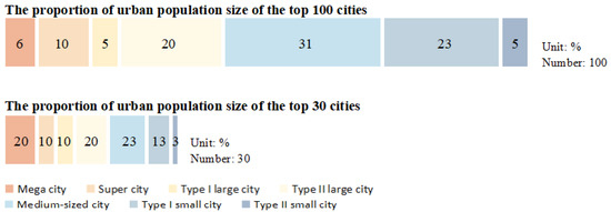
Figure 10.
The urban population size distribution among the top 100 and 30 evaluated cities.
Table 4.
Correlation analysis of city scores with urban population size and urban economic aggregate. (Note: The population data comes from the 7th National Population Census Bulletin released by the National Bureau of Statistics on 11 May 2021).
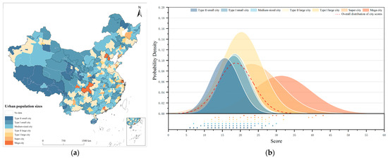
Figure 11.
(a) Spatial distribution of urban population sizes. (b) Probability density of city scores under normal distribution stratified by urban population size classification. Correlation analysis between urban population size and city scores within each city. (Note: The population data come from the 7th National Population Census Bulletin released by the National Bureau of Statistics on 11 May 2021).
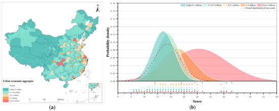
Figure 12.
(a) Spatial distribution of urban economic aggregate. (b) Probability density of city scores under normal distribution stratified by urban economic aggregate classification. Correlation analysis between urban economic aggregate and city scores within each city.
5. Discussion
Based on global experience, incorporating climate change considerations into spatial planning emerges as a vital strategy to mitigate climate vulnerability and bolster urban resilience. Developed nations have already embedded climate change issues into their comprehensive policy agendas, while their developing counterparts are still grappling with the integration of climate change into existing policies [88,89]. China, the most populous developing country worldwide, hosts a substantial 63.89% of its population in urban areas occupying a mere 1.08% of its national territory [90,91]. Moreover, China ranks among the most susceptible regions globally to the impacts of climate change. The rapid urbanization and unsustainable economic growth patterns have compounded the adverse effects of climate change across many of its cities. Notably, escalating carbon emissions have triggered prolonged climatic anomalies and the frequent occurrence of extreme weather events in recent years. Consequently, both central and local governments have taken resolute steps to promote the carbon peaking and carbon neutrality strategy, expediting the implementation of a series of policies at various areas and geographic scales to address this multifaceted challenge [92].
This study conducts a comprehensive assessment of Chinese cities regarding their incorporation of climate change considerations into local-level territorial and spatial planning, both holistically and across specific component indicators. The findings reveal that the primary factors contributing to the suboptimal performance of territorial and spatial planning are insufficient awareness, lack of corresponding assessments and analyses, and deficiencies in action and engagement.
5.1. The Awareness Component
Awareness measures the extent to which local jurisdictions understand the concept of climate change. Local jurisdictions need to acknowledge the scientific underpinning of climate change, climate variability, and global warming [6,19]. Climate change awareness should be coupled with climate change assessments to formulate effective strategies and actions in response to climate change [93]. The analysis should encompass long-term goals for greenhouse gas (GHG) emissions, addressing the primary drivers, sources, or contributors to climate change [94], and conducting vulnerability assessments for climate change in vulnerable places and populations [95,96]. However, the territorial and spatial planning of the majority of Chinese cities fails to incorporate the concepts of climate change, its impacts, and its associated assessments. Conversely, only economically developed cities such as Hong Kong, Macao, Shanghai, Beijing, Chongqing, and Shenzhen, along with certain coastal and inland cities, have proactively integrated climate change as a central focus within their territorial and spatial planning. They have clearly articulated the ramifications of climate change and underscored the importance of integrating risk assessments into the planning and decision-making process. In contrast, other cities do not explicitly mention the concept of climate change. However, they indirectly engage in adaptive measures in response to climate change, and may even propose relevant indicators. Nevertheless, these efforts predominantly draw from the shared principles and general practices of territorial and spatial planning within the framework of ecological civilization reform. The broad objectives associated with this approach result both in a deficiency in providing a precise response to climate change and in considering its more profound socio-economic repercussions.
5.2. The Analysis Component
Despite the fact that the territorial and spatial planning in the majority of cities emphasizes ecological prioritization and sustainable green development, as well as the establishment of resilient and secure urban areas, there is a conspicuous absence of vulnerability and specialized assessment analyses concerning climate change. In addition, the evaluation of the spatial environment in individual cities does not address the issue of climate change. This suggests that prevailing territorial and spatial planning typically hinges on resource and environmental factors, neglecting the impacts, risks, and vulnerabilities associated with climate change [47,59].
5.3. The Action Component
The study underscores the significance of local practices within the action component. Actions should encompass policies, tools, and strategies addressing climate change adaptation issues in natural environments, built environments, and human health [72]. The implementation of territorial and spatial planning influences multiple facets of climate change adaptation, encompassing urban form [81], land use and development [74,97], transportation [9,98], agriculture and water management [59], nature conservation [99], energy [26,98,100], resilience [101], and monitoring and evaluation [72,102].
Within the action component, the territorial and spatial planning of most cities has clearly delineated a range of adaptive measures and associated indicators in areas such as land use and development control, transportation, public services, and green infrastructure. However, most of these strategies have largely overlooked the context of global climate change. While local governments have made relevant policies on these issues, which are amongst the main drivers of climate change vulnerability, they are not shaped into instruments to reduce the climate change impact and vulnerability. Furthermore, in areas such as the built environment, resilience and disaster control, monitoring, and assessment, China’s urban territorial and spatial planning mentions these aspects to a lesser extent and lacks institutional arrangements that would enable the long-term and stable implementation of these measures. Moreover, innovatively incorporating climate change issues into various spatial planning actions—in comparison to related research in other countries—could have a significant impact on addressing the effects of climate change. For example, strategies like green infrastructure and energy efficiency in physical development, climate proofing of long-lasting infrastructure like transport systems in the cities, accounting for GHG emissions from various sectors, and strategies such as cross-sectoral cooperation in resource management, etc., can be easily improvised into current action responses [103,104,105,106,107]. These aspects require strengthening and refinement.
It is noteworthy that, in alignment with the principles of ecological civilization and the objectives of achieving carbon peaking and carbon neutrality, the assessment results of territorial and spatial planning in the action component reveal the gradual development of a strategic framework for climate change adaptation at the city level. Additionally, certain measures have introduced corresponding control indicators. This framework primarily encompasses the demarcation and management of the “three zones and three lines,” the integrated safeguarding and utilization of natural resources, the formulation of ecological security patterns, the establishment of secure and resilient infrastructure, a comprehensive disaster prevention system, the development of a public service facility network with the “living circle” as its nucleus, and the advancement and adoption of clean and renewable energy sources. Simultaneously, in consideration of diverse resource and environmental attributes, cities have proposed key strategies to address climate change. For instance, environmentally vulnerable and resource-dependent cities in Northwestern China, such as Baiyin, Jiayuguan, and Zhangye in Gansu Province, have established objectives and initiatives aimed at diminishing carbon emissions and augmenting carbon sequestration. Chuzhou in Anhui Province and Baise in Guangxi Province both prioritize mitigating the urban heat island effect and enhancing comfort by devising urban wind corridor systems to foster the development of climate-resilient cities. Putian in Fujian Province and Zhoushan in Zhejiang Province place emphasis on safeguarding and regulating marine areas and island coastlines. Certain cities in Hainan Province, Guizhou Province, and Henan Province all include proposals for the establishment of an integrated framework encompassing cross-regional ecological conservation, regional watershed administration, and collaborative protection of ecological corridors.
5.4. Performance Differences between Large and Small Cities
The evaluation results indicate that cities with larger populations and more developed economies demonstrate heightened awareness of climate change, in-depth analysis of climate change adaptation, increased capability to implement adaptation measures, and a greater level of specificity in their approaches. These findings offer supporting evidence for the notion that the propensity to formulate adaptation plans correlates with a city’s population size [76,108], while wealth and effective governance emerge as pivotal catalysts for climate change adaptation initiatives [109]. Large cities, characterized by rapid population growth, heightened natural resource demands, increased susceptibility to climate change, and heightened vulnerability of urban infrastructure, necessitate more extensive deliberation on climate change adaptation measures. Likewise, robust economic security and elevated governance standards offer avenues for monitoring and assessing the implementation of such plans.
Existing research on spatial planning policies for climate change adaptation in developed countries or economies [1,28,110] and developing countries’ cities [26,111] indicates that the majority of local authorities have recognized the need to incorporate climate change considerations into public policies and possess a certain level of climate change awareness. This represents the first step in determining their ability to successfully implement appropriate adaptation measures. Furthermore, influenced by the degree of economic and social development, developed countries are better equipped to scientifically assess the risks and impacts of climate change, allowing them to propose a targeted series of responsive actions. In this regard, variations in city size, wealth, and national regulatory capacity are the primary factors contributing to differences in the performance of various cities.
6. Conclusions and Prospect
6.1. Conclusions and Research Limitations
Within the 3A framework, this study comprehensively investigates the adaptability of Chinese cities to climate change through territorial and spatial planning. The evaluation results reveal that the role of territorial and spatial planning in integrating climate change issues at the city level requires further enhancement. The overall performance is marked by a low awareness of climate change, limited analytical capabilities regarding climate change, and a basic foundation for responding to climate change. Performance varies among cities. Moreover, the performance of territorial and spatial planning in addressing climate change exhibits significant variation across cities. Economically developed and densely populated large cities tend to exhibit greater specificity in quantifiable climate adaptation indicators and measures. In summary, this study underscores the significance of acknowledging the concept, impacts, and assessment of climate change within the domain of territorial and spatial planning. Furthermore, it reinforces the pivotal role of territorial and spatial planning in local-level climate change adaptation.
This study represents the first exploration of the policy shift and the existing gaps between policy and reality in the field of spatial planning in China under the context of climate change adaptation. The proposed evaluation framework serves as an effective tool for gauging the stance of cities regarding climate change issues and their spatial policies. It contributes to the scientific discourse on the unequal climate change adaptation capacities among cities, offering empirical evidence from China. It also highlights the primary strengths and weaknesses in the incorporation of climate change concerns into territorial and spatial planning. Additionally, the evaluation framework can be adjusted according to regional needs and contexts. This China-focused research has relevance for other countries and regions, offering valuable insights for policy borrowing. However, it should be noted that the usability of the 3A approach in this study presents challenges when applied to developing countries and cities at various stages of spatial planning. The potential impacts of various sectoral policies under spatial plans are unknown. It could be hard to apply the 3A approach directly, as it is unable to capture the essence of comprehensive development on climate change issues. The majority of developing countries are still struggling with basic issues like physical development, poverty, and environment in general, and ways to integrate climate change issues along with these basic issues is a big challenge. Meanwhile, the analysis revealed certain limitations warranting further investigation. Firstly, regarding data sources, it is important to note that all territorial and spatial planning documents used in this study are publicly available versions, which represent condensed summaries of the complete texts. This limitation arises from the fact that many local governments do not disclose the final versions to the public. Secondly, concerning research methodology, this study exclusively employed qualitative analysis for evaluating territorial and spatial planning. Notably, it did not include quantitative analysis. Furthermore, regarding research scope, this study did not delve into the specifics of detailed and specialized planning within the territorial and spatial planning system. These specific plans may encompass more detailed climate change adaptation measures, including unit control planning, ecological restoration planning, infrastructure planning, transportation planning, disaster prevention planning, and urban renewal planning.
6.2. Suggestions for Future Research
It is noteworthy that China’s territorial and spatial planning—at all levels—is not synchronized with climate change adaptation efforts. Furthermore, the theoretical and technical foundation of territorial and spatial planning for climate change adaptation is underdeveloped. Therefore, based on the findings of this study, we recommend enhancing the quality of climate change adaptation in urban territorial and spatial planning through the following measures.
In terms of technical analysis, China should expedite the establishment of a territorial and spatial planning assessment system for climate adaptation. Firstly, in alignment with cities’ future development trajectories, and leveraging multi-scenario predictions of climate change trends, there is a need to seamlessly integrate meteorological disaster and climate vulnerability assessments into the “dual assessment” framework of territorial and spatial planning [57]. Secondly, it is crucial to establish technical methodologies for urban-scale climate impact assessments. This should be accompanied by a clarification of adaptive strategies, as well as the protection and optimization of the built environment at the neighborhood scale. Lastly, in conjunction with urban physical examination and assessment efforts, there is a need to integrate the monitoring and assessment of climate adaptation into the planning physical examination and assessment procedures. Additionally, the establishment of a “monitor-diagnostic-early warning” technical system is recommended [63].
At the spatial level, it is crucial to bolster research on climate change adaptation within China’s pivotal regions and watershed cities. Examples of these efforts include intensifying research for identifying critical climate change risks and devising climate change adaptation action plans—spatial adaptation strategies, fostering cross-regional collaboration, and integrating additional standards into territorial and spatial planning—to bolster climate resilience. In addition, research endeavors will extend to climate-resilient technologies and methodologies in regions susceptible to climate change impacts, including infrastructure, water resources, coastal areas, forests, and other ecosystems. The aim is to furnish “no-regret” or “low-regret” solutions conducive to sustainable urban development [59].
At the mechanism design level, cities—recognized as areas bearing high climate risks and central entities in climate governance—ought to conduct an analysis of critical climate risk zones within municipal-level territorial and spatial planning. This analysis should encompass the elucidation of overarching goals for climate change adaptation, the delineation of precise, binding indicators, and a concentrated effort on adaptation measures addressing urban heat island effects, water systems, infrastructure, human habitat, human health, and architecture [112]. Furthermore, given that climate change adaptation encompasses multiple sectors, fields, and disciplines [29], it is imperative to establish mechanisms for climate change adaptation that span across sectors and regions. One suggestion is for the Ministry of Natural Resources to take the lead in enhancing the summarization and sharing of climate change adaptation experiences in large cities, thereby improving the climate change adaptation capacity of underdeveloped small cities. This initiative also reflects the Chinese government’s aim to promote coordinated and interconnected development between mega-cities within urban clusters and surrounding small and medium-sized cities [113]. Simultaneously, it is essential to enhance the coordination between sectoral adaptation policies and adaptation planning, optimizing alignment between adaptation policy objectives and available resources. Additionally, it is advisable to establish horizontal cooperation mechanisms involving local key stakeholders, including industries, professional organizations, and civic representatives. These mechanisms can serve the purpose of heightening public awareness regarding climate change and adaptation, distinguishing between the impacts of natural disasters and climate change, and promoting the engagement of diverse stakeholders in the urban governance decision-making process. This approach facilitates the identification of social and economic vulnerabilities and the development of corresponding plans. For instance, vulnerable groups such as the elderly, children, individuals with lower socio-economic status, and women are at increased risk of exposure to extreme weather events [114,115].
Subsequent research may further track and analyze various detailed and specialized planning efforts. It could delve deeper into the selection of criteria in the action component of the framework, emphasizing institutional capacity and strategies to enhance cross-sector collaboration, as well as refining monitoring and evaluation mechanisms for territorial and spatial master planning. Additionally, it could strengthen discussions on the vertical and horizontal dimensions of climate-adaptive spatial governance.
Author Contributions
Conceptualization, K.Z. and S.W.; methodology, K.Z. and S.W.; software, K.Z. and Y.F.; validation, K.Z. and Y.F.; formal analysis, K.Z. and S.W.; resources, K.Z.; data curation, K.Z. and Y.F.; writing—original draft preparation, K.Z. and S.W.; writing—review and editing, K.Z. and S.W.; visualization, Y.F.; supervision, K.Z. and S.W.; project administration, K.Z. and S.W.; funding acquisition, S.W. All authors have read and agreed to the published version of the manuscript.
Funding
This research was funded by the Major Research Program of the National Social Science Foundation of China (22VHQ009). The authors are grateful for the receipt of these funds. The APC was funded by S.W.
Data Availability Statement
All territorial and spatial planning public disclosure documents are readily available online via the websites of local governments or natural resources departments in China.
Conflicts of Interest
The authors declare no conflict of interest.
Appendix A
Table A1.
Performance of territorial and spatial plans for the sample of Chinese cities.
Table A1.
Performance of territorial and spatial plans for the sample of Chinese cities.
| Province | City | Overall Plan Performance | Awareness | Analysis | Action |
|---|---|---|---|---|---|
| Shanghai | 0.83 | 0.08 | 0.88 | 0.69 | |
| Beijing | 0.67 | 0.08 | 0.86 | 0.65 | |
| Tianjin | 0.33 | 0.08 | 0.43 | 0.28 | |
| Chongqing | 0.50 | 0.00 | 0.50 | 0.33 | |
| Hongkong | 0.83 | 0.33 | 0.74 | 0.63 | |
| Macau | 0.83 | 0.00 | 0.55 | 0.41 | |
| Fujian | Fuzhou | 0.33 | 0.00 | 0.38 | 0.22 |
| Longyan | 0.33 | 0.00 | 0.38 | 0.22 | |
| Nanping | 0.33 | 0.00 | 0.45 | 0.28 | |
| Ningde | 0.33 | 0.00 | 0.52 | 0.33 | |
| Putian | 0.50 | 0.00 | 0.40 | 0.26 | |
| Quanzhou | 0.33 | 0.00 | 0.33 | 0.19 | |
| Sanming | 0.50 | 0.00 | 0.33 | 0.20 | |
| Xiamen | 0.33 | 0.00 | 0.48 | 0.30 | |
| Zhangzhou | 0.33 | 0.00 | 0.36 | 0.20 | |
| Anhui | Lu’an | 0.17 | 0.00 | 0.24 | 0.09 |
| Suzhou | 0.33 | 0.00 | 0.29 | 0.15 | |
| Anqing | 0.17 | 0.00 | 0.33 | 0.17 | |
| Bengbu | 0.33 | 0.00 | 0.38 | 0.22 | |
| Bozhou | 0.33 | 0.00 | 0.43 | 0.26 | |
| Chizhou | 0.33 | 0.00 | 0.43 | 0.26 | |
| Fuyang | 0.33 | 0.08 | 0.38 | 0.24 | |
| Hefei | 0.17 | 0.00 | 0.38 | 0.20 | |
| Huaibei | 0.33 | 0.08 | 0.36 | 0.22 | |
| Huainan | 0.17 | 0.00 | 0.31 | 0.15 | |
| Huangshan | 0.33 | 0.00 | 0.33 | 0.19 | |
| Maanshan | 0.33 | 0.00 | 0.40 | 0.24 | |
| Tongling | 0.33 | 0.00 | 0.36 | 0.20 | |
| Wuhu | 0.33 | 0.08 | 0.38 | 0.24 | |
| Xuancheng | 0.33 | 0.00 | 0.38 | 0.22 | |
| Chuzhou | 0.33 | 0.00 | 0.45 | 0.28 | |
| Gansu | Baiyin | 0.33 | 0.00 | 0.43 | 0.26 |
| Dingxi | 0.17 | 0.00 | 0.17 | 0.04 | |
| Gannan | 0.33 | 0.00 | 0.33 | 0.19 | |
| Jiayuguan | 0.33 | 0.00 | 0.33 | 0.19 | |
| Jinchang | 0.33 | 0.00 | 0.24 | 0.11 | |
| Jiuquan | 0.17 | 0.00 | 0.36 | 0.19 | |
| Lanzhou | 0.33 | 0.00 | 0.40 | 0.24 | |
| Linxia | 0.33 | 0.00 | 0.38 | 0.22 | |
| Longnan | 0.50 | 0.00 | 0.48 | 0.31 | |
| Pingliang | 0.33 | 0.00 | 0.26 | 0.13 | |
| Qingyang | 0.33 | 0.00 | 0.33 | 0.19 | |
| Tianshui | 0.33 | 0.00 | 0.43 | 0.26 | |
| Wuwei | 0.33 | 0.00 | 0.36 | 0.20 | |
| Zhangye | 0.33 | 0.00 | 0.26 | 0.13 | |
| Guangdong | Chaozhou | 0.33 | 0.00 | 0.33 | 0.19 |
| Dongguan | 0.33 | 0.00 | 0.55 | 0.35 | |
| Foshan | 0.33 | 0.00 | 0.38 | 0.22 | |
| Guangzhou | 0.33 | 0.08 | 0.62 | 0.43 | |
| Heyuan | 0.33 | 0.00 | 0.43 | 0.26 | |
| Huizhou | 0.33 | 0.08 | 0.48 | 0.31 | |
| Jiangmen | 0.33 | 0.00 | 0.45 | 0.28 | |
| Jieyang | 0.33 | 0.08 | 0.52 | 0.35 | |
| Maoming | 0.50 | 0.00 | 0.26 | 0.15 | |
| Meizhou | 0.33 | 0.00 | 0.29 | 0.15 | |
| Qingyuan | 0.33 | 0.00 | 0.45 | 0.28 | |
| Shantou | 0.33 | 0.00 | 0.38 | 0.22 | |
| Shanwei | 0.33 | 0.00 | 0.43 | 0.26 | |
| Shaoguan | 0.33 | 0.00 | 0.31 | 0.17 | |
| Shenzhen | 0.50 | 0.00 | 0.69 | 0.48 | |
| Yangjiang | 0.33 | 0.00 | 0.29 | 0.15 | |
| Yunfu | 0.33 | 0.00 | 0.43 | 0.26 | |
| Zhanjiang | 0.33 | 0.00 | 0.55 | 0.35 | |
| Zhaoqing | 0.33 | 0.00 | 0.29 | 0.15 | |
| Zhongshan | 0.50 | 0.00 | 0.50 | 0.33 | |
| Zhuhai | 0.33 | 0.00 | 0.45 | 0.28 | |
| Guangxi | Baise | 0.50 | 0.00 | 0.43 | 0.28 |
| Beihai | 0.33 | 0.00 | 0.38 | 0.22 | |
| Hechi | 0.33 | 0.00 | 0.33 | 0.19 | |
| Hezhou | 0.33 | 0.00 | 0.45 | 0.28 | |
| Chongzuo | 0.50 | 0.00 | 0.62 | 0.43 | |
| Fangchenggang | 0.17 | 0.00 | 0.24 | 0.09 | |
| Guigang | 0.33 | 0.08 | 0.38 | 0.24 | |
| Guilin | 0.33 | 0.00 | 0.50 | 0.31 | |
| Laibin | 0.33 | 0.00 | 0.33 | 0.19 | |
| Nanning | 0.33 | 0.08 | 0.55 | 0.37 | |
| Qinzhou | 0.33 | 0.00 | 0.50 | 0.31 | |
| Wuzhou | 0.33 | 0.00 | 0.48 | 0.30 | |
| Yulin | 0.33 | 0.00 | 0.52 | 0.33 | |
| Liuzhou | 0.33 | 0.00 | 0.36 | 0.20 | |
| Guizhou | Guiyang | 0.33 | 0.00 | 0.40 | 0.24 |
| Qianxinan | 0.33 | 0.00 | 0.36 | 0.20 | |
| Anshun | 0.50 | 0.08 | 0.45 | 0.31 | |
| Bijie | 0.50 | 0.08 | 0.40 | 0.28 | |
| Liupanshui | 0.33 | 0.00 | 0.45 | 0.28 | |
| Qiandongnan | 0.50 | 0.00 | 0.40 | 0.26 | |
| Qiannan | 0.33 | 0.00 | 0.24 | 0.11 | |
| Tongren | 0.33 | 0.00 | 0.38 | 0.22 | |
| Zunyi | 0.50 | 0.00 | 0.33 | 0.20 | |
| Hainan | Baisha | 0.33 | 0.00 | 0.26 | 0.13 |
| Baoting | 0.33 | 0.00 | 0.31 | 0.17 | |
| Changjiang | 0.33 | 0.00 | 0.43 | 0.26 | |
| Chengmai | 0.33 | 0.00 | 0.31 | 0.17 | |
| Danzhou | 0.33 | 0.00 | 0.52 | 0.33 | |
| Dingan | 0.33 | 0.00 | 0.12 | 0.02 | |
| Dongfang | 0.50 | 0.00 | 0.43 | 0.28 | |
| Haikou | 0.33 | 0.00 | 0.55 | 0.35 | |
| Ledong | 0.33 | 0.00 | 0.33 | 0.19 | |
| Lingao | 0.33 | 0.00 | 0.60 | 0.39 | |
| Lingshui | 0.33 | 0.00 | 0.48 | 0.30 | |
| Qionghai | 0.33 | 0.00 | 0.36 | 0.20 | |
| Qiongzhong | 0.33 | 0.00 | 0.24 | 0.11 | |
| Sanya | 0.33 | 0.00 | 0.36 | 0.20 | |
| Tunchang | 0.17 | 0.00 | 0.26 | 0.11 | |
| Wanning | 0.33 | 0.00 | 0.33 | 0.19 | |
| Wenchang | 0.33 | 0.00 | 0.26 | 0.13 | |
| Wuzhishan | 0.33 | 0.00 | 0.38 | 0.22 | |
| Hebei | Baoding | 0.33 | 0.00 | 0.60 | 0.39 |
| Cangzhou | 0.33 | 0.00 | 0.40 | 0.24 | |
| Hengshui | 0.33 | 0.00 | 0.26 | 0.13 | |
| Chengde | 0.33 | 0.00 | 0.29 | 0.15 | |
| Handan | 0.33 | 0.00 | 0.52 | 0.33 | |
| Langfang | 0.33 | 0.08 | 0.43 | 0.28 | |
| Qinhuangdao | 0.33 | 0.00 | 0.24 | 0.11 | |
| Shijiazhuang | 0.33 | 0.00 | 0.38 | 0.22 | |
| Tangshan | 0.33 | 0.00 | 0.43 | 0.26 | |
| Xingtai | 0.33 | 0.00 | 0.31 | 0.17 | |
| Zhangjiakou | 0.17 | 0.00 | 0.29 | 0.13 | |
| Henan | Anyang | 0.33 | 0.00 | 0.48 | 0.30 |
| Hebi | 0.33 | 0.00 | 0.40 | 0.24 | |
| Kaifeng | 0.33 | 0.00 | 0.31 | 0.17 | |
| Luoyang | 0.33 | 0.00 | 0.36 | 0.20 | |
| Puyang | 0.33 | 0.00 | 0.38 | 0.22 | |
| Sanmenxia | 0.33 | 0.00 | 0.38 | 0.22 | |
| Shangqiu | 0.33 | 0.00 | 0.29 | 0.15 | |
| Xinyang | 0.33 | 0.00 | 0.36 | 0.20 | |
| Jiyuan | 0.33 | 0.00 | 0.36 | 0.20 | |
| Jiaozuo | 0.33 | 0.00 | 0.26 | 0.13 | |
| Luohe | 0.50 | 0.00 | 0.43 | 0.28 | |
| Nanyang | 0.33 | 0.00 | 0.33 | 0.19 | |
| Pingdingshan | 0.33 | 0.00 | 0.45 | 0.28 | |
| Xinxiang | 0.33 | 0.00 | 0.29 | 0.15 | |
| Xuchang | 0.33 | 0.00 | 0.40 | 0.24 | |
| Zhengzhou | 0.33 | 0.00 | 0.52 | 0.33 | |
| Zhoukou | 0.33 | 0.00 | 0.38 | 0.22 | |
| Zhumadian | 0.33 | 0.00 | 0.38 | 0.22 | |
| Heilongjiang | Daqing | 0.33 | 0.00 | 0.38 | 0.22 |
| Haerbin | 0.33 | 0.00 | 0.26 | 0.13 | |
| Heihe | 0.33 | 0.00 | 0.40 | 0.24 | |
| Daxinganling | 0.33 | 0.00 | 0.45 | 0.28 | |
| Hegang | 0.17 | 0.00 | 0.29 | 0.13 | |
| Jixi | 0.33 | 0.00 | 0.40 | 0.24 | |
| Jiamusi | 0.33 | 0.00 | 0.50 | 0.31 | |
| Mudanjiang | 0.33 | 0.00 | 0.36 | 0.20 | |
| Qitaihe | 0.33 | 0.00 | 0.40 | 0.24 | |
| Qiqihaer | 0.33 | 0.00 | 0.38 | 0.22 | |
| Shuangyashan | 0.33 | 0.00 | 0.45 | 0.28 | |
| Yichun | 0.33 | 0.00 | 0.48 | 0.30 | |
| Hubei | Enshi | 0.33 | 0.00 | 0.40 | 0.24 |
| Jingmen | 0.33 | 0.00 | 0.55 | 0.35 | |
| Shennongjialinqu | 0.33 | 0.00 | 0.31 | 0.17 | |
| Xianning | 0.33 | 0.00 | 0.45 | 0.28 | |
| Xiangyang | 0.33 | 0.00 | 0.45 | 0.28 | |
| Xiaogan | 0.33 | 0.33 | 0.48 | 0.37 | |
| Ezhou | 0.33 | 0.00 | 0.48 | 0.30 | |
| Huanggang | 0.33 | 0.00 | 0.50 | 0.31 | |
| Huangshi | 0.33 | 0.00 | 0.43 | 0.26 | |
| Jingzhou | 0.33 | 0.00 | 0.31 | 0.17 | |
| Qianjiang | 0.33 | 0.00 | 0.60 | 0.39 | |
| Shiyan | 0.33 | 0.00 | 0.43 | 0.26 | |
| Suizhou | 0.33 | 0.00 | 0.48 | 0.30 | |
| Tianmen | 0.33 | 0.17 | 0.36 | 0.24 | |
| Wuhan | 0.33 | 0.00 | 0.50 | 0.31 | |
| Xiantao | 0.33 | 0.00 | 0.36 | 0.20 | |
| Yichang | 0.33 | 0.00 | 0.38 | 0.22 | |
| Hunan | Chenzhou | 0.33 | 0.00 | 0.55 | 0.35 |
| Hengyang | 0.33 | 0.00 | 0.57 | 0.37 | |
| Huaihua | 0.33 | 0.00 | 0.62 | 0.41 | |
| Yiyang | 0.33 | 0.00 | 0.50 | 0.31 | |
| Yueyang | 0.33 | 0.00 | 0.62 | 0.41 | |
| Changsha | 0.33 | 0.08 | 0.55 | 0.37 | |
| Loudi | 0.33 | 0.00 | 0.52 | 0.33 | |
| Shaoyang | 0.33 | 0.00 | 0.45 | 0.28 | |
| Xiangxizhou | 0.33 | 0.00 | 0.33 | 0.19 | |
| Yongzhou | 0.33 | 0.00 | 0.43 | 0.26 | |
| Zhangjiajie | 0.33 | 0.00 | 0.36 | 0.20 | |
| Changde | 0.33 | 0.00 | 0.50 | 0.31 | |
| Zhuzhou | 0.33 | 0.00 | 0.50 | 0.31 | |
| Xiangtan | 0.33 | 0.00 | 0.50 | 0.31 | |
| Jilin | Changchun | 0.17 | 0.00 | 0.31 | 0.15 |
| Baicheng | 0.33 | 0.00 | 0.43 | 0.26 | |
| Baishan | 0.33 | 0.00 | 0.40 | 0.24 | |
| Jilin | 0.33 | 0.00 | 0.40 | 0.24 | |
| Liaoyuan | 0.17 | 0.00 | 0.24 | 0.09 | |
| Siping | 0.33 | 0.33 | 0.48 | 0.37 | |
| Songyuan | 0.33 | 0.00 | 0.36 | 0.20 | |
| Tonghua | 0.33 | 0.00 | 0.38 | 0.22 | |
| Yanbian | 0.33 | 0.00 | 0.33 | 0.19 | |
| Jiangsu | Changzhou | 0.33 | 0.00 | 0.71 | 0.48 |
| Huaian | 0.33 | 0.00 | 0.43 | 0.26 | |
| Lianyungang | 0.33 | 0.00 | 0.50 | 0.31 | |
| Nanjing | 0.33 | 0.50 | 0.74 | 0.61 | |
| Nantong | 0.33 | 0.00 | 0.48 | 0.30 | |
| Suzhou | 0.33 | 0.00 | 0.52 | 0.33 | |
| Suqian | 0.33 | 0.00 | 0.40 | 0.24 | |
| Taizhou | 0.33 | 0.00 | 0.43 | 0.26 | |
| Wuxi | 0.33 | 0.00 | 0.60 | 0.39 | |
| Xuzhou | 0.33 | 0.17 | 0.45 | 0.31 | |
| Yancheng | 0.33 | 0.00 | 0.45 | 0.28 | |
| Yangzhou | 0.33 | 0.00 | 0.24 | 0.11 | |
| Zhenjiang | 0.33 | 0.08 | 0.64 | 0.44 | |
| Jiangxi | Fuzhou | 0.33 | 0.00 | 0.38 | 0.22 |
| Ganzhou | 0.33 | 0.08 | 0.31 | 0.19 | |
| Jian | 0.33 | 0.00 | 0.50 | 0.31 | |
| Jingdezhen | 0.33 | 0.00 | 0.36 | 0.20 | |
| Jiujiang | 0.33 | 0.00 | 0.29 | 0.15 | |
| Nanchang | 0.33 | 0.00 | 0.24 | 0.11 | |
| Pingxiang | 0.33 | 0.00 | 0.45 | 0.28 | |
| Shangrao | 0.17 | 0.00 | 0.21 | 0.07 | |
| Xinyu | 0.33 | 0.00 | 0.43 | 0.26 | |
| Yichun | 0.33 | 0.00 | 0.45 | 0.28 | |
| Yingtan | 0.33 | 0.00 | 0.21 | 0.09 | |
| Liaoning | Yingkou | 0.33 | 0.00 | 0.31 | 0.17 |
| Benxi | 0.17 | 0.00 | 0.31 | 0.15 | |
| Dalian | 0.33 | 0.08 | 0.45 | 0.30 | |
| Anshan | 0.33 | 0.00 | 0.38 | 0.22 | |
| Chaoyang | 0.33 | 0.00 | 0.52 | 0.33 | |
| Dandong | 0.33 | 0.00 | 0.31 | 0.17 | |
| Fushun | 0.17 | 0.00 | 0.29 | 0.13 | |
| Fuxin | 0.33 | 0.08 | 0.43 | 0.28 | |
| Huludao | 0.33 | 0.00 | 0.48 | 0.30 | |
| Jinzhou | 0.33 | 0.00 | 0.33 | 0.19 | |
| Liaoyang | 0.33 | 0.00 | 0.36 | 0.20 | |
| Panjin | 0.33 | 0.00 | 0.38 | 0.22 | |
| Shenyang | 0.33 | 0.00 | 0.52 | 0.33 | |
| Tieling | 0.33 | 0.17 | 0.43 | 0.30 | |
| Inner-Mongolia | Alashan | 0.33 | 0.00 | 0.29 | 0.15 |
| Bayannaoer | 0.33 | 0.00 | 0.40 | 0.24 | |
| Baotou | 0.33 | 0.00 | 0.40 | 0.24 | |
| Chifeng | 0.33 | 0.00 | 0.43 | 0.26 | |
| Eerduosi | 0.33 | 0.00 | 0.33 | 0.19 | |
| Hulunhaote | 0.33 | 0.00 | 0.45 | 0.28 | |
| Hulunbeier | 0.33 | 0.00 | 0.24 | 0.11 | |
| Tongliao | 0.33 | 0.00 | 0.38 | 0.22 | |
| Wuhai | 0.33 | 0.00 | 0.33 | 0.19 | |
| Wulanchabu | 0.33 | 0.00 | 0.29 | 0.15 | |
| Xilingol League | 0.33 | 0.00 | 0.33 | 0.19 | |
| Xinganmeng | 0.33 | 0.00 | 0.36 | 0.20 | |
| Ningxia | Guyuan | 0.33 | 0.00 | 0.33 | 0.19 |
| Shizuishan | 0.33 | 0.00 | 0.29 | 0.15 | |
| Wuzhong | 0.33 | 0.00 | 0.38 | 0.22 | |
| Yinchuan | 0.33 | 0.00 | 0.38 | 0.22 | |
| Zhongwei | 0.33 | 0.00 | 0.43 | 0.26 | |
| Qinghai | Haibei Tibetan Autonomous Prefecture | 0.17 | 0.00 | 0.12 | 0.00 |
| Haixi Mongolian and Tibetan Autonomous Prefecture | 0.67 | 0.17 | 0.38 | 0.30 | |
| Guoluo Tibetan Autonomous Prefecture | 0.33 | 0.00 | 0.26 | 0.13 | |
| Haidong | 0.33 | 0.08 | 0.33 | 0.20 | |
| Hainan Tibetan Autonomous Prefecture | 0.17 | 0.00 | 0.33 | 0.17 | |
| Huangnan Tibetan Autonomous Prefecture | 0.33 | 0.00 | 0.31 | 0.17 | |
| Xining | 0.33 | 0.00 | 0.38 | 0.22 | |
| Yushu Tibetan Autonomous Prefecture | 0.33 | 0.00 | 0.26 | 0.13 | |
| Shandong | Jinan | 0.50 | 0.00 | 0.40 | 0.26 |
| Jining | 0.33 | 0.00 | 0.40 | 0.24 | |
| Rizhao | 0.17 | 0.00 | 0.21 | 0.07 | |
| Binzhou | 0.33 | 0.00 | 0.24 | 0.11 | |
| Dezhou | 0.50 | 0.00 | 0.45 | 0.30 | |
| Dongying | 0.67 | 0.00 | 0.48 | 0.33 | |
| Heze | 0.33 | 0.00 | 0.40 | 0.24 | |
| Liaocheng | 0.33 | 0.00 | 0.33 | 0.19 | |
| Linyi | 0.33 | 0.00 | 0.40 | 0.24 | |
| Qingddao | 0.33 | 0.00 | 0.36 | 0.20 | |
| Taian | 0.33 | 0.00 | 0.29 | 0.15 | |
| Weihai | 0.33 | 0.08 | 0.33 | 0.20 | |
| Weifang | 0.33 | 0.08 | 0.40 | 0.26 | |
| Yantai | 0.33 | 0.00 | 0.36 | 0.20 | |
| Zaozhuang | 0.33 | 0.00 | 0.40 | 0.24 | |
| Zibo | 0.33 | 0.00 | 0.48 | 0.30 | |
| Shanxi | Datong | 0.33 | 0.17 | 0.48 | 0.33 |
| Jincheng | 0.33 | 0.00 | 0.48 | 0.30 | |
| Jinzhong | 0.33 | 0.00 | 0.36 | 0.20 | |
| Linfen | 0.33 | 0.00 | 0.40 | 0.24 | |
| Lvliang | 0.33 | 0.00 | 0.38 | 0.22 | |
| Shuozhou | 0.33 | 0.08 | 0.17 | 0.07 | |
| Taiyuan | 0.33 | 0.00 | 0.36 | 0.20 | |
| Xinzhou | 0.33 | 0.00 | 0.33 | 0.19 | |
| Yangquan | 0.33 | 0.00 | 0.12 | 0.02 | |
| Yuncheng | 0.17 | 0.00 | 0.26 | 0.11 | |
| Changzhi | 0.33 | 0.00 | 0.43 | 0.26 | |
| Shanxi | Ankang | 0.17 | 0.00 | 0.19 | 0.06 |
| Baoji | 0.33 | 0.00 | 0.40 | 0.24 | |
| Hanzhong | 0.33 | 0.00 | 0.31 | 0.17 | |
| Shangluo | 0.50 | 0.00 | 0.55 | 0.37 | |
| Tongchuan | 0.33 | 0.00 | 0.38 | 0.22 | |
| Weinan | 0.33 | 0.00 | 0.38 | 0.22 | |
| Xi‘an | 0.50 | 0.00 | 0.60 | 0.41 | |
| Xianyang | 0.33 | 0.00 | 0.55 | 0.35 | |
| Yan’an | 0.33 | 0.00 | 0.36 | 0.20 | |
| Yulin | 0.50 | 0.00 | 0.43 | 0.28 | |
| Sichuan | Aba Tibetan and Qiang Autonomous Prefecture | 0.50 | 0.00 | 0.48 | 0.31 |
| Bazhong | 0.50 | 0.00 | 0.50 | 0.33 | |
| Dazhou | 0.33 | 0.00 | 0.40 | 0.24 | |
| Deyang | 0.33 | 0.00 | 0.38 | 0.22 | |
| Ganzi Tibetan Autonomous Prefecture | 0.33 | 0.00 | 0.31 | 0.17 | |
| Guang’an | 0.17 | 0.00 | 0.33 | 0.17 | |
| Guangyuan | 0.33 | 0.00 | 0.36 | 0.20 | |
| Chengdu | 0.50 | 0.00 | 0.64 | 0.44 | |
| Leshan | 0.33 | 0.00 | 0.31 | 0.17 | |
| Luzhou | 0.33 | 0.00 | 0.40 | 0.24 | |
| Meishan | 0.17 | 0.00 | 0.31 | 0.15 | |
| Mianyang | 0.50 | 0.00 | 0.26 | 0.15 | |
| Nanchong | 0.33 | 0.00 | 0.55 | 0.35 | |
| Neijiang | 0.33 | 0.00 | 0.31 | 0.17 | |
| Panzhihua | 0.33 | 0.00 | 0.40 | 0.24 | |
| Suining | 0.33 | 0.00 | 0.40 | 0.24 | |
| Ya’an | 0.33 | 0.17 | 0.33 | 0.22 | |
| Yibin | 0.33 | 0.00 | 0.36 | 0.20 | |
| Ziyang | 0.33 | 0.00 | 0.45 | 0.28 | |
| Zigong | 0.33 | 0.00 | 0.36 | 0.20 | |
| Liangshan Yi Autonomous Prefecture | 0.67 | 0.00 | 0.50 | 0.35 | |
| Xizang | Ngari Area | 0.33 | 0.00 | 0.38 | 0.22 |
| Changdu | 0.33 | 0.00 | 0.36 | 0.20 | |
| Lasa | 0.33 | 0.00 | 0.55 | 0.35 | |
| Linzhi | 0.33 | 0.00 | 0.33 | 0.19 | |
| Naqu | 0.50 | 0.00 | 0.40 | 0.26 | |
| Rikaze | 0.50 | 0.00 | 0.40 | 0.26 | |
| Shanan | 0.33 | 0.00 | 0.33 | 0.19 | |
| Xinjiang | Akesu | 0.50 | 0.00 | 0.36 | 0.22 |
| Aletai | 0.33 | 0.00 | 0.43 | 0.26 | |
| Bayinguoleng | 0.50 | 0.00 | 0.43 | 0.28 | |
| Boertala Mongolian Autonomous Prefecture | 0.33 | 0.00 | 0.31 | 0.17 | |
| Changji Hui Autonomous Prefecture | 0.33 | 0.00 | 0.36 | 0.20 | |
| Hami | 0.33 | 0.00 | 0.43 | 0.26 | |
| Hotan area | 0.33 | 0.00 | 0.36 | 0.20 | |
| Kashi | 0.33 | 0.00 | 0.36 | 0.20 | |
| Kelamayi | 0.33 | 0.00 | 0.38 | 0.22 | |
| Kezilesukeerzi Prefecture | 0.33 | 0.00 | 0.31 | 0.17 | |
| Tacheng | 0.33 | 0.00 | 0.29 | 0.15 | |
| Tulufan | 0.33 | 0.00 | 0.31 | 0.17 | |
| Wulumuqi | 0.50 | 0.00 | 0.50 | 0.33 | |
| Yili Prefecture | 0.33 | 0.00 | 0.24 | 0.11 | |
| Huyanghe | 0.17 | 0.00 | 0.29 | 0.13 | |
| Kekedala | 0.33 | 0.00 | 0.33 | 0.19 | |
| Shihezi | 0.33 | 0.00 | 0.33 | 0.19 | |
| Tiemenguan | 0.17 | 0.00 | 0.24 | 0.09 | |
| Beitun | 0.17 | 0.00 | 0.29 | 0.13 | |
| Alaer | 0.33 | 0.00 | 0.31 | 0.17 | |
| Wujiaqu | 0.17 | 0.00 | 0.31 | 0.15 | |
| Tumushuke | 0.33 | 0.00 | 0.21 | 0.09 | |
| Xinxing | 0.33 | 0.00 | 0.33 | 0.19 | |
| Kunyu | 0.33 | 0.00 | 0.38 | 0.22 | |
| Shuanghe | 0.17 | 0.00 | 0.29 | 0.13 | |
| Yunnan | Kunming | 0.33 | 0.00 | 0.50 | 0.31 |
| Baoshan | 0.33 | 0.00 | 0.52 | 0.33 | |
| Chuxiong | 0.33 | 0.00 | 0.24 | 0.11 | |
| Dali | 0.33 | 0.08 | 0.52 | 0.35 | |
| Dehong | 0.17 | 0.17 | 0.19 | 0.09 | |
| Diqing | 0.33 | 0.00 | 0.38 | 0.22 | |
| Honghe | 0.33 | 0.00 | 0.48 | 0.30 | |
| Lijiang | 0.33 | 0.08 | 0.45 | 0.30 | |
| Lincang | 0.33 | 0.17 | 0.40 | 0.28 | |
| Nujiang | 0.33 | 0.00 | 0.36 | 0.20 | |
| Puer | 0.33 | 0.08 | 0.29 | 0.17 | |
| Qvjing | 0.17 | 0.00 | 0.33 | 0.17 | |
| Wenshan | 0.33 | 0.00 | 0.40 | 0.24 | |
| Xishuangbanna | 0.33 | 0.00 | 0.31 | 0.17 | |
| Yuxi | 0.33 | 0.00 | 0.43 | 0.26 | |
| Zhaotong | 0.33 | 0.00 | 0.31 | 0.17 | |
| Zhejiang | Hangzhou | 0.33 | 0.00 | 0.29 | 0.15 |
| Huzhou | 0.33 | 0.17 | 0.33 | 0.22 | |
| Jiaxing | 0.33 | 0.00 | 0.43 | 0.26 | |
| Jinhua | 0.50 | 0.00 | 0.36 | 0.22 | |
| Lishui | 0.33 | 0.00 | 0.29 | 0.15 | |
| Ningbo | 0.33 | 0.00 | 0.38 | 0.22 | |
| Qvzhou | 0.33 | 0.00 | 0.31 | 0.17 | |
| Shaoxing | 0.33 | 0.00 | 0.29 | 0.15 | |
| Taizhou | 0.33 | 0.00 | 0.26 | 0.13 | |
| Wenzhou | 0.33 | 0.00 | 0.33 | 0.19 | |
| Zhoushan | 0.33 | 0.00 | 0.43 | 0.26 |
Notes: The maximum score for each component of awareness, analysis, and action is 1. The maximum performance score for any territorial and spatial plan (after standardization) is 1.
Note
| 1 | In accordance with the State Council’s Notice on Adjusting the Classification Standards for Urban Size, cities are categorized into five groups and seven tiers, determined by the statistical criteria of permanent urban residents. Small cities are those with a permanent population of under 500,000. Among them, cities with over 200,000 residents but less than 500,000 are classified as Type I small cities, while those with fewer than 200,000 residents are designated as Type II small cities. Medium-sized cities encompass urban populations exceeding 500,000 but falling short of 1 million. Large cities comprise urban areas with populations exceeding 1 million but below 5 million. Within this category, cities with over 3 million residents but under 5 million are categorized as Type I large cities, while those with more than 1 million but less than 3 million residents are classified as Type II large cities. Super cities are defined as those with a permanent urban population exceeding 5 million but below 10 million. Mega cities are those with a permanent urban population exceeding 10 million. |
References
- Preston, B.L.; Westaway, R.M.; Yuen, E.J. Climate adaptation planning in practice: An evaluation of adaptation plans from three developed nations. Mitig. Adapt. Strat. Glob. Chang. 2011, 16, 407–438. [Google Scholar] [CrossRef]
- Adger, W.N.; Arnell, N.W.; Tompkins, E.L. Successful adaptation to climate change across scales. Glob. Environ. Chang. 2005, 15, 77–86. [Google Scholar] [CrossRef]
- Rosenzweig, C.; Solecki, W.; Hammer, S.A.; Mehrotra, S. Cities lead the way in climate change action. Nature 2010, 467, 909–911. [Google Scholar] [CrossRef]
- Pachauri, K.; Meyer, A. Climate change 2014. synthesis report. Environ. Policy Collect. 2014, 27, 408. [Google Scholar] [CrossRef]
- Betsill, M.M. Mitigating climate change in US cities: Opportunities and obstacles. Local Environ. 2001, 6, 393–406. [Google Scholar] [CrossRef]
- Lindseth, G. The Cities for Climate Protection Campaign (CCPC) and the framing of local climate policy. Local Environ. 2004, 9, 325–336. [Google Scholar] [CrossRef]
- Grimm, N.B.; Faeth, S.H.; Golubiewski, N.E.; Redman, C.L.; Wu, J.; Bai, X.; Briggs, J.M. Global change and the ecology of cities. Science 2008, 319, 756–760. [Google Scholar] [CrossRef] [PubMed]
- Pacala, S.; Socolow, R. Stabilization wedge: Solving the climate problem for the next 50 years with current technologies. Science 2004, 305, 968–972. [Google Scholar] [CrossRef] [PubMed]
- Biesbroek, G.R.; Swart, R.J.; van der Knaap, W.G.M. The mitigation–adaptation dichotomy and the role of spatial planning. Habitat Int. 2009, 33, 230–237. [Google Scholar] [CrossRef]
- Hurlimann, A.C.; March, A.P. The role of spatial planning in adapting to climate change. WIREs Clim. Chang. 2012, 3, 477–488. [Google Scholar] [CrossRef]
- Cobbinah, P.B.; Asibey, M.O.; Opoku-Gyamfi, M.; Peprah, C. Urban planning and climate change in Ghana. J. Urban Manag. 2019, 8, 261–271. [Google Scholar] [CrossRef]
- Wilson, E.; Piper, J. Spatial Planning and Climate Change, 1st ed.; Routledge: London, UK; New York, NY, USA, 2010; ISBN 97804154959121. [Google Scholar]
- Jong, M.D.; Joss, S.; Schraven, D.; Zhan, C.; Weijnen, M. Sustainable–smart–resilient–low carbon–eco–knowledge cities; making sense of a multitude of concepts promoting sustainable urbanization. J. Clean. Prod. 2015, 109, 25–38. [Google Scholar] [CrossRef]
- Goosen, H.; Groot-Reichwein, M.A.M.D.; Masselink, L.; Koekoek, A.; Swart, R.; Bessembinder, J.; Witte, J.M.P.; Stuyt, L.; Blom-Zandstra, G.; Immerzeel, W. Climate adaptation services for the Netherlands: An operational approach to support spatial adaptation planning. Reg. Environ. Chang. 2014, 14, 1035–1048. [Google Scholar] [CrossRef]
- Roggema, R. Adaptation to Climate Change: A Spatial Challenge; Springer: Dordrecht, The Netherlands, 2009; ISBN 9781402093593. [Google Scholar]
- Hughes, S. A meta-analysis of urban climate change adaptation planning in the U.S. Urban Clim. 2015, 14, 17–29. [Google Scholar] [CrossRef]
- Rickards, L.; Ison, R.; Fünfgeld, H.; Wiseman, J. Opening and closing the future: Climate change, adaptation, and scenario planning. Environ. Plan. C Gov. Policy 2014, 32, 587–602. [Google Scholar] [CrossRef]
- Nowak, M.J.; Monteiro, R.; Olcina-Cantos, J.; Vagiona, D.G. Spatial Planning Response to the Challenges of Climate Change Adaptation: An Analysis of Selected Instruments and Good Practices in Europe. Sustainability 2023, 15, 10431. [Google Scholar] [CrossRef]
- Wilson, E. Adapting to Climate Change at the Local Level: The Spatial Planning Response. Local Environ. 2006, 11, 609–625. [Google Scholar] [CrossRef]
- Hurlimann, A.; Moosavi, S.; Browne, G.R. Urban planning policy must do more to integrate climate change adaptation and mitigation actions. Land Use Policy 2020, 101, 105188. [Google Scholar] [CrossRef]
- Andrew, M.; Anita, F.; Jan, M. Policy design, spatial planning and climate change adaptation: A case study from Australia. Environ. Plan. Manag. 2014, 58, 1432–1453. [Google Scholar] [CrossRef]
- Jiang, Y.; Lange, E.; Shi, T.; Li, L. Adaptation Development Strategies of Urban Planning to Deal with Climatic Change—Cases Studies in UK, and Some Other Countries. Mod. Urban Res. 2012, 27, 13–20. [Google Scholar]
- Song, Y.; Liu, Z.D.; Peng, K. How Should Urban Planning Respond to Climate Change: Learning from Local Strategies in the U.S. Urban Plan. Int. 2011, 26, 3–10. [Google Scholar]
- Wei, W.; Qin, L.F. Adaptive Urban Rural Planning Development For Climate Change And Protection In Germany. Planners 2012, 11, 123–127. [Google Scholar]
- Dong, X.; Zhang, C.H. Urban Renewal under the Concept of Climate Adaptation: Experience and Implications from Germany. Urban Environ. Stud. 2021, 2, 99–112. [Google Scholar]
- Kumar, P.; Geneletti, D. How are climate change concerns addressed by spatial plans? An evaluation framework, and an application to Indian cities. Land Use Policy 2015, 42, 210–226. [Google Scholar] [CrossRef]
- United Nations Environment Program. Emissions Gap Report 2020; United Nations Environment Program: Nairobi, Kenya, 2020; ISBN 97892807381241. [Google Scholar]
- Moser, S.C.; Luers, A.L. Managing Climate Risks in California: The Need to Engage Resource Managers for Successful Adaptation to Change. Clim. Chang. 2008, 87, 309–322. [Google Scholar] [CrossRef]
- Wang, W.; Wu, Z.Y.; Li, G.Y. Transformative adaptation of territorial space government towards climate change. Planners 2023, 39, 11–20. [Google Scholar]
- Committee for the preparation of the Fourth National Assessment Report on Climate Change. Fourth National Assessment Report on Climate Change; Science Press: Beijing, China, 2022; ISBN 9787030727589.
- The State Council of the People’s Republic of China. Notice of The State Council on the Issuance of China’s National Plan to Address Climate Change. Available online: https://www.gov.cn/govweb/gongbao/content/2007/content_678918.htm (accessed on 3 June 2021).
- The Xinhua News Agency. Outline of the 12th Five-Year Plan for National Economic and Social Development. Available online: http://www.gov.cn/2011lh/content_1825838.htm (accessed on 16 March 2021).
- National Development and Reform Commission of the People’s Republic of China. Circular on the Issuance of the National Strategy for Adaptation to Climate Change. Available online: https://www.gov.cn/zwgk/2013-12/09/content_2544880.htm (accessed on 18 November 2021).
- National Development and Reform Commission of the People’s Republic of China. Notice of the National Development and Reform Commission on the Issuance of the National Climate Change Plan (2014–2020). Available online: http://www.scio.gov.cn/ztk/xwfb/2014/32144/xgzc32154/Document/1387114/1387114.htm (accessed on 25 November 2021).
- National Development and Reform Commission of the People’s Republic of China, National Development and Reform Commission of the People’s Republic of China and Ministry of Housing and Urban-Rural Development of the People’s Republic of China Issued a Notice on the Pilot Work of Climate-Resilient City Construction. Available online: https://www.gov.cn/xinwen/2017-02/25/content_5170863.htm#1 (accessed on 25 February 2020).
- Ministry of Ecology and Environment of the People’s Republic of China. Notice on the Issuance of the National Climate Change Adaptation Strategy 2035. Available online: https://www.gov.cn/zhengce/zhengceku/2022-06/14/content_5695555.htm (accessed on 10 May 2022).
- Ministry of Ecology and Environment of the People’s Republic of China. Notice on Deepening Pilot Work on the Construction of Climate-Resilient Cities. Available online: https://www.mee.gov.cn/xxgk2018/xxgk/xxgk05/202308/t20230825_1039387.html (accessed on 25 August 2023).
- Chen, W.B. Promoting the establishment of spatial planning system in our country scientifically—Discussing the relationship between several urban planning. Mod. City 2015, 1–4. [Google Scholar]
- Li, L.; Han, G.F.; Zhao, Y.F.; Guo, J. Function of “Multi-Plan Integration” in Territorial Spatial Planning System. J. Hum. Settl. West China 2020, 35, 43–49. [Google Scholar] [CrossRef]
- Zhang, J.; Zhao, M. On the Reformation of Urban Comprehensive Planning System: From the Viewpoint of ‘Multi-Plans Coordination’. Shanghai Urban Plan. Rev. 2015, 6, 8–13. [Google Scholar]
- Yuan, Q.F.; Tan, S.M.; Li, G. Objectives, Functions, And Orientation Of Spatial Planning. Planners 2018, 34, 11–17+25. [Google Scholar]
- Zhao, M. On the Construction Logic and Implementation Agenda of the Territory Development Planning System of China. Urban Plan. Forum 2019, 4, 8–15. [Google Scholar] [CrossRef]
- Communist Website. The Urbanization Working Conference of the CPC Central Committee Was Held in Beijing. Available online: https://news.12371.cn/2013/12/15/ARTI1387057117696375.shtml (accessed on 15 December 2021).
- The Xinhua News Agency. The CPC Central Committee and The State Council Issue the Overall Plan for the Reform of the Ecological Civilization System. Available online: https://www.gov.cn/guowuyuan/2015-09/21/content_2936327.html (accessed on 21 September 2021).
- The Xinhua News Agency. The CPC Central Committee Issues Plan for Deepening Reform of Party and State Institutions. Available online: https://www.gov.cn/zhengce/2018-03/21/content_5276191.htm1 (accessed on 21 March 2021).
- The Xinhua News Agency. Several Opinions of the Central Committee of the CPC and the State Council on the Establishment of a Territorial Spatial Planning System and the Supervision of its Implementation. Available online: https://www.gov.cn/zhengce/2019-05/23/content_5394187.html (accessed on 23 May 2021).
- Yang, L.Q.; Chen, W.; Wu, J.W.; Wei, S.; Yan, L. Spatial Planning Adapting to Climate Change: Progress in the Content and Methodology. Urban Plan. Int. 2020, 35, 96–100+3701–3703. [Google Scholar] [CrossRef]
- Zheng, Y. Resilient City: Mainstreaming Climate Risk Management and Adaptation to Climate Change into Urban Planning. Urban Stud. 2012, 19, 47–51. [Google Scholar]
- Yan, W.T. Mitigation·Adaptation—Research Agendas in Urban Planning Responding to Climate Change. J. Hum. Settl. West China 2013, 3, 31–36. [Google Scholar] [CrossRef]
- Zheng, Y. Cognition Study on Urban Planning for Adaptation to Climate Change: A Case from Shanghai’s Policy Makers. Clim. Chang. Res. 2016, 12, 118–123. [Google Scholar]
- Cai, Y.N.; Wen, Z.P. Climate Adaptability Planning Technology For Urban Resilience Promotion. Planners 2017, 33, 18–24. [Google Scholar]
- Ye, Z.D. Climate Adaptation and Statutory Urban Rural Planning System for Chinese Cities: Contents, Techniques, Decision Process. Mod. Urban Res. 2017, 9, 2–7. [Google Scholar]
- Shen, P.; Liang, J.Y. Climate Change Adaptation Strategies in Spatial Planning: Experience and Lessons of Taiwan’s “Spatial Planning”. Urban Plan. Int. 2022, 37, 120–128. [Google Scholar] [CrossRef]
- Xie, Z.H.; Liu, B.; Yan, X.D.; Meng, C.; Xu, X.; Liu, Y.; Qin, P.; Jia, B.; Xie, J.; Li, R.; et al. Effects of implementation of urban planning in response to climate change. Prog. Geogr. 2020, 39, 120–131. [Google Scholar] [CrossRef]
- Li, X.; Zhang, Y. The Solution and Localization of Climate-based Adaptation under Climate Change: Definition, Concept Framework and Interpretation. Chin. Landsc. Archit. 2020, 36, 73–77. [Google Scholar] [CrossRef]
- Xu, Y.J. Development strategy of China’s coastal cities for addressing climate change. Clim. Chang. Res. 2020, 16, 88–98. [Google Scholar]
- Fu, L.; Cao, Y.; Yang, X. Progress analysis and policy recommendation on climate adaptation city pilots in China. Clim. Chang. Res. 2020, 16, 770–774. [Google Scholar]
- Li, H.; Qiu, P.; Zhang, X.; Wang, Y.; Zhao, C. Summarizing the Planning Elements of Climate Adaptive Cities and Assessing the Plans of 28 Pilots in China. Environ. Prot. 2020, 48, 17–24. [Google Scholar] [CrossRef]
- Wu, Z.Y. Integrating adaptation to climate change into territorial spatial planning: Progress, dilemma and strategy. Clim. Chang. Res. 2021, 17, 559–569. [Google Scholar]
- Zhang, B.; Men, X.; Wang, W.; Yang, M.; Yang, J.; Yang, J.; Li, L.; Zhang, X.; Jin, X.; Luo, Y.; et al. Code of Practice for City Examination and Evaluation in Spatial Planning: TD/T 1063-2021; Geology Press: Beijing, China, 2021; ISBN 12116.501. [Google Scholar]
- Ministry of Natural Resources. Notice of the General Office of the Ministry of Natural Resources on Issuing the Guide for the Preparation of Provincial Territorial Spatial Planning (Trial). Available online: http://gi.mnr.gov.cn/202001/t20200120_2498397.html (accessed on 17 January 2020).
- Ministry of Natural Resources. Notice of the General Office of the Ministry of Natural Resources on Issuing the Guide for the Preparation of Municipal Territorial Spatial Planning (Trial). Available online: http://gi.mnr.gov.cn/202009/t20200924_2561550.html (accessed on 22 September 2020).
- Wang, K.; Jiang, G.X.; Luo, Y.; Bing, Q.L. Territorial Space Planning Response to Climate Change. Planners 2023, 39, 5–10. [Google Scholar]
- Qin, J. Study on Flood Adaptation Strategy of Territorial Space Planning in Response to Climate Change. Planners 2023, 39, 30–37. [Google Scholar]
- Zong, L.; Yang, F.; Pei, X.S. Implementing Climate Change Adaptation in Territory Spatial Planning Systems: Challenges and Approaches Based on Practices in Guiyang. Int. J. Environ. Res. Public Health 2023, 20, 490. [Google Scholar] [CrossRef] [PubMed]
- Zeng, S.; Wang, Q.; Tian, J. The Theoretical Framework and Planning Response of Resilient Territorial Space Planning in Response to Climate Change. Planners 2023, 39, 21–29. [Google Scholar]
- Pan, H.; Dai, S.; Zhao, Y.; Sun, J.; Liu, Q.; Zeng, P.; Shi, H.; Wang, J.; Zhou, J.; Wang, K. Academic Writing of “Urban Resilience and Spatial Planning in Response to Climate Change”. Urban Plan. Forum 2021, 1, 1–10. [Google Scholar] [CrossRef]
- Urwin, K.; Jordan, A. Does Public Policy Support or Undermine Climate Change Adaptation? Exploring Policy Interplay across Different Scales of Governance. Glob. Environ. Chang. 2008, 18, 180–191. [Google Scholar] [CrossRef]
- Brooks, N.; Anderson, S.; Ayers, J.; Burton, I.; Tellam, I. Tracking Adaptation and Measuring Development; IIED Climate Change Working Paper No. 1, November 2011; International Institute for Environment and Development (IIED): Amsterdam, The Netherlands, 2011; ISSN 2048-786X (Online). [Google Scholar]
- UNDP. Adaptation Policy Frameworks for Climate Change: Developing Strategies Policies and Measures; Cambridge University Press: Cambridge, UK; New York, NY, USA, 2004; ISBN 0 521 61760 X. [Google Scholar]
- UNISDR. How to Make Cities More Resilient—A Handbook for Mayors and Local Government Leaders; United Nations International Strategy for Disaster Reduction: Geneva, Switzerland, 2012; ISBN 978-92-1-101496-9. [Google Scholar]
- Tang, Z.; Brody, S.D.; Quinn, C.; Chang, L.; Wei, T. Moving from Agenda to Action: Evaluating Local Climate Change Action Plans. J. Environ. Plan. Manag. 2010, 53, 41–62. [Google Scholar] [CrossRef]
- Hurlimann, A.C.; Moosavi, S.; Browne, G.R. Climate change transformation: A definition and typology to guide decision making in urban environments. Sustain. Cities Soc. 2021, 70, 102890. [Google Scholar] [CrossRef]
- Füssel, H.-M. Adaptation Planning for Climate Change: Concepts, Assessment Approaches, and Key Lessons. Sustain. Sci. 2007, 2, 265–275. [Google Scholar] [CrossRef]
- Guyadeen, D.; Thistlethwaite, J.; Henstra, D. Evaluating the Quality of Municipal Climate Change Plans in Canada. Clim. Chang. 2019, 152, 121–143. [Google Scholar] [CrossRef]
- Reckien, D.; Flacke, J.; Olazabal, M.; Heidrich, O. The Influence of Drivers and Barriers on Urban Adaptation and Mitigation Plans—An Empirical Analysis of European Cities. PLoS ONE 2015, 10, e0135597. [Google Scholar] [CrossRef] [PubMed]
- Field, C.B.; Barros, V.; Stocker, T.F.; Qin, D.; Dokken, D.J.; Ebi, K.L.; Mastrandrea, M.D.; Mach, K.J.; Plattner, G.-K.; Allen, S.K.; et al. Managing the Risks of Extreme Events and Disasters to Advance Climate Change Adaptation; Special Report of Working Groups I and II of the Intergovernmental Panel on Climate Change; Cambridge University Press: Cambridge, UK; New York, NY, USA, 2012; ISBN 978-1-107-02506-6. [Google Scholar]
- Koetse, M.J.; Rietveld, P. The Impact of Climate Change and Weather on Transport: An Overview of Empirical Findings. Transp. Res. Part D Transp. Environ. 2009, 14, 205–221. [Google Scholar] [CrossRef]
- Barnett, J.; Adger, W.N. Climate Change, Human Security and Violent Conflict. Political Geogr. 2007, 26, 639–655. [Google Scholar] [CrossRef]
- Office of the Deputy Prime Minister. The Planning Response to Climate Change: Advice on Better Practice; Office of the Deputy Prime Minister: London, UK, 2004; ISBN 1851127151. [Google Scholar]
- IPCC. Climate Change 2014: Mitigation of Climate Change. In Contribution of Working Group III to the Fifth Assessment Report of the Intergovernmental Panel on Climate Change; Edenhofer, O., Pichs-Madruga, R., Sokona, Y., Farahani, E., Kadner, S., Seyboth, K., Adler, A., Baum, I., Brunner, S., Eickemeier, P., et al., Eds.; Cambridge University Press: Cambridge, UK; New York, NY, USA, 2014; ISBN 978-1-107-05821-7. [Google Scholar]
- Thoidou, E. Spatial Planning and Climate Adaptation: Challenges of Land Protection in a Peri-Urban Area of the Mediterranean City of Thessaloniki. Sustainability 2021, 13, 4456. [Google Scholar] [CrossRef]
- Hallegatte, S. Strategies to Adapt to an Uncertain Climate Change. Glob. Environ. Chang. 2009, 19, 240–247. [Google Scholar] [CrossRef]
- Eriksen, S.E.H.; Klein, R.J.T.; Ulsrud, K.; Næss, L.O.; O’Brien, K. Climate Change Adaptation and Poverty Reduction: Key interactions and critical measures. Glob. Environ. Chang. Hum. Secur. 2007, 1, 1–44. [Google Scholar]
- Matthews, T.; Lo, A.Y.; Byrne, J.A. Reconceptualizing Green Infrastructure for Climate Change Adaptation: Barriers to Adoption and Drivers for Uptake by Spatial Planners. Landsc. Urban Plan. 2015, 138, 155–163. [Google Scholar] [CrossRef]
- IPCC. Climate Change 2022: Impacts, Adaptation and Vulnerability. In Contribution of Working Group II to the Sixth Assessment Report of the Intergovernmental Panel on Climate Change; Pörtner, H.-O., Roberts, D.C., Tignor, M., Poloczanska, E.S., Mintenbeck, K., Alegría, A., Craig, M., Langsdorf, S., Löschke, S., Möller, V., et al., Eds.; Cambridge University Press: Cambridge, UK; New York, NY, USA, 2022; ISSN 9781009325844. [Google Scholar]
- People.com.cn. The Authorities Speak Opening | Ministry of Natural Resources: Actively Promote the Modernization of Harmonious Coexistence between Man and Nature. Available online: https://baijiahao.baidu.com/s?id=1771094149246610504&wfr=spider&for=pc (accessed on 11 July 2023).
- Berrang-Ford, L.; Ford, J.D.; Paterson, J. Are We Adapting to Climate Change? Glob. Environ. Chang. 2011, 21, 25–33. [Google Scholar] [CrossRef]
- Gagnon-Lebrun, F.; Agrawala, S. Implementing Adaptation in Developed Countries: An Analysis of Progress and Trends. Clim. Policy 2007, 7, 392–408. [Google Scholar] [CrossRef]
- Office of the Seventh National Census Leading Group of The State Council. China Census Yearbook-2020; China Statistics Press: Beijing, China, 2022; ISBN 978-7-5037-9771-2.
- Ministry of Natural Resources. Major Data Bulletin of the Third National Land Survey. Available online: https://www.mnr.gov.cn/dt/ywbb/202108/t20210826_2678340.html (accessed on 26 August 2021).
- Information Office of the State Council of the People’s Republic of China. China’s Policies and Actions to Address Climate Change. Available online: https://www.gov.cn/zhengce/202110/27/content_5646697.html (accessed on 27 October 2021).
- Preston, B.L.; Yuen, E.J.; Westaway, R.M. Putting Vulnerability to Climate Change on the Map: A Review of Approaches, Benefits, and Risks. Sustain. Sci. 2011, 6, 177–202. [Google Scholar] [CrossRef]
- Angel, D.P.; Attoh, S.; Kromm, D.; Dehart, J.; Slocum, R.; White, S. The drivers of Greenhouse Gas emissions: What do we learn from local case studies? Local Environ. 1998, 3, 263–277. [Google Scholar] [CrossRef]
- Snover, A.K.; Whitely Binder, L.C.; Lopez, J.; Willmott, E.; Kay, J.E.; Howell, D.; Simmonds, J. Preparing for Climate Change: A Guidebook for Local, Regional, and State Governments; ICLEI—Local Governments for Sustainability: Oakland, CA, USA, 2007. [Google Scholar] [CrossRef]
- Rędzińska, K.; Piotrkowska, M. Urban Planning and Design for Building Neighborhood Resilience to Climate Change. Land 2020, 9, 387. [Google Scholar] [CrossRef]
- Corell, E.; Betsill, M. A comparative look at ngo influence in international environmental negotiations: Desertification and climate change. Glob. Environ. Politics 2001, 1, 86–107. [Google Scholar] [CrossRef]
- Andrews, C.J. Energy conversion goes local: Implications for planners. Am. Plan. Assoc. 2008, 74, 231–254. [Google Scholar] [CrossRef]
- Cochran, T.; Mayors Climate Protection Center. Climate Protection Strategies and Best Practices Guide—2007 Mayors Climate Protection Summit Edition; The United States Conference of Mayors: Washington, DC, USA, 2007. [Google Scholar]
- Nelson, H.T. Planning implications from the interactions between renewable energy programs and carbon regulation. Environ. Plan. Manag. 2008, 51, 581–596. [Google Scholar] [CrossRef]
- Carter, J.G.; Cavan, G.; Connelly, A.; Guy, S.; Handley, J.; Kazmierczak, A. Climate Change and the City: Building Capacity for Urban Adaptation. Prog. Plan. 2015, 95, 1–66. [Google Scholar] [CrossRef]
- California Air Resources Board, California Climate Action Registry, ICLEI—Local Governments for Sustainability The Climate Registry. Draft Local Government Operations Protocol. 2008. Available online: http://edgeservices.bing.com/edgesvc/redirect?url=http%3A%2F%2Fwww.caclimateregistry.org%2Ftools%2Fprotocols%2Findustry-specific-protocols%2Flocal-government-operations%2F&hash=EsXczFUMfSa4Ca0z0n91hs5h8Ewy3RcKgliJghgb%2FEQ%3D&key=psc-underside&usparams=cvid%3A51D%7CBingProd%7C6AF0F92BA36EF25C6016BF2830F3C400EE4F1933C5A6A373BC9D06321674C4CA%5Ertone%3APrecise (accessed on 19 June 2021).
- European Environment Agency (EEA). Urban Adaptation to Climate Change in Europe-Challenges and Opportunities for Cities Together With Supportive National and European Policies; EEA: Oslo, Norway, 2012; ISBN 978-92-9213-308-5.
- Carter, J.G. Climate change adaptation in European cities. Curr. Opin. Environ. Sustain. 2011, 3, 193–198. [Google Scholar] [CrossRef]
- United Nations Human Settlements Programme (UN-Habitat). Cities and Climate Change: Global Report on Human Settlements 2011; Earthscan: London, UK; Washington, DC, USA, 2011; ISBN 978-1-84971-370-2. [Google Scholar]
- Stefan, G.; Mark, F. National Climate Change Adaptation Strategies of European States from a Spatial Planning and Development Perspective. Eur. Plan. Stud. 2012, 20, 27–48. [Google Scholar] [CrossRef]
- Kruse, S.; Marco, P. Adaptive Capacities of Spatial Planning in the Context of Climate Change in the European Alps. Eur. Plan. Stud. 2014, 22, 2620–2638. [Google Scholar] [CrossRef]
- Berrang-Ford, L.; Ford, J.D.; Lesnikowski, A.; Poutiainen, C.; Barrera, M.; Heymann, S.J. What Drives National Adaptation? A Global Assessment. Clim. Chang. 2014, 124, 441–450. [Google Scholar] [CrossRef]
- Araos, M.; Berrang-Ford, L.; Ford, J.D.; Austin, S.E.; Biesbroek, R.; Lesnikowski, A. Climate Change Adaptation Planning in Large Cities: A Systematic Global Assessment. Environ. Sci. Policy 2016, 66, 375–382. [Google Scholar] [CrossRef]
- Reckien, D.; Salvia, M.; Heidrich, O.; Church, J.M.; Pietrapertosa, F.; De Gregorio-Hurtado, S.; D’Alonzo, V.; Foley, A.; Simoes, S.G.; Lorencová, E.K.; et al. How are cities planning to respond to climate change? Assessment of local climate plans from 885 cities in the EU-28. Clean. Prod. 2018, 191, 207–219. [Google Scholar] [CrossRef]
- Pieterse, A.; Toit, J.D.; Niekerk, W.V. Climate change adaptation mainstreaming in the planning instruments of two South African local municipalities. Dev. S. Afr. 2021, 38, 493–508. [Google Scholar] [CrossRef]
- Leng, H.; Li, S. International Experience and Inspiration of Adaptive Planning to Cope with Health Risks of Climate Change. Urban Plan. Int. 2021, 5, 23–30. [Google Scholar] [CrossRef]
- National Development and Reform Commission (NDRC). Promoting the Development of Super-Large Cities in Urban Agglomerations to Drive the Development of Surrounding Small and Medium-Sized Cities. Available online: https://m.thepaper.cn/newsDetail_forward_15875232 (accessed on 3 June 2022). (In Chinese)
- Benevolenza, M.A.; DeRigne, L. The Impact of Climate Change and Natural Disasters on Vulnerable Populations: A Systematic Review of Literature. J. Hum. Behav. Soc. Environ. 2019, 29, 266–281. [Google Scholar] [CrossRef]
- Ojala, M. Regulating Worry, Promoting Hope: How Do Children, Adolescents, and Young Adults Cope with Climate Change? Int. J. Environ. Sci. Educ. 2012, 7, 537–561. [Google Scholar]
Disclaimer/Publisher’s Note: The statements, opinions and data contained in all publications are solely those of the individual author(s) and contributor(s) and not of MDPI and/or the editor(s). MDPI and/or the editor(s) disclaim responsibility for any injury to people or property resulting from any ideas, methods, instructions or products referred to in the content. |
© 2023 by the authors. Licensee MDPI, Basel, Switzerland. This article is an open access article distributed under the terms and conditions of the Creative Commons Attribution (CC BY) license (https://creativecommons.org/licenses/by/4.0/).