1. Introduction
In the ongoing urbanisation processes, the delineation between urban and rural domains becomes increasingly indistinct. This phenomenon underscores the imperative for the creation of versatile and ecologically sound transitional zones that confer advantages upon both urban and rural landscapes. Within this context, the emergence of agricultural parks has become a strategic instrument in the realm of urban planning, dedicated to the management of these hybrid territories, with a primary objective of fostering sustainable land utilisation and community advancement.
The aim of the article is twofold: to analyse the multifunctionality of farms in the periurban area of Rome in order to map the typologies of food products and services on which the relationship between farms and the metropolitan population is based and to expose a methodological path for identifying the area of a Metropolitan Agricultural Park (MAP). According to our proposal, the MAP planning tool can guarantee the valorisation of the role of multifunctional farms and the strengthening of the relationship between these farms and the urban population of the metropolitan area.
The research stems from the Food Atlas project, carried out for the Metropolitan City of Rome, with the aim of studying and mapping the agrifood system and proposing recommendations and feasible projects. Among the premises of the whole Food Atlas, there is the recognition that the intense process of urbanisation has created the conditions for the spread of periurban city forms. Urbanisation processes have characterised recent decades with various models of expansion and dispersion of the city, as well as temporal complexity of stratifications, due to fractioning of agrarian grids and compromises of natural areas due to settlement pressure, massive presence of infrastructure, illegal occupations, and unclear definitions of local and regional boundaries [
1]. At the same time, urbanisation processes convert the periurban areas into a challenging part, the guidance of which requires a comprehensive understanding of them in all their dimensions [
2]. Among the various definitions of periurban, we can recall Piorr et al. [
1], who identifies it as “an area between urban settlement and rural hinterland” specifying that “larger periurban areas may include smaller towns and villages within an urban agglomeration”. Such areas have much lower densities than those that can be defined as urban, while maintaining alarming growth rates, estimated to be 3.7 times higher in Europe than urban areas with loss of habitat, landscape, and natural values [
3]. Furthermore, periurban areas are transition spaces, where the changes in different land uses are incessantly occurring. Against this backdrop, the distinction between urban and non-urban areas are no longer functional to describe the territorial outcomes of these transformations [
4]. Mortoja et al. [
5] affirm that periurban demarcation should take into account a number of regional and local factors, such as political system and institutional governance, social and environmental characteristics, and economic drivers underpinning the periurban development.
The attractiveness of periurban areas is motivated to a large extent by the possibility of residency at lower costs than in more densely urbanised areas. Commuting, relying mainly on road mobility, characterise these forms of residency. On top of that there is the possibility of living in a context with rural characteristics potentially offering a certain variety of open spaces as resources of ecosystem services. On the other hand, the process of periurbanisation has generated considerable environmental impacts, including soil consumption, to the extent that fertile agricultural soils and natural areas lose their functionality [
3,
6], depleting the possibility of producing ecosystem services related to them [
7]. Competition for land use is arguably the main problem facing periurban agriculture: farmers are often faced with strong financial incentives to sell land for new construction, sometimes exacerbating land-use speculation and distortive land ownership dynamics [
1]. Paradoxically, precisely in these contexts dramatically faced with the risk of losing its agricultural and functional characteristics, new forms of ‘civil economy’ are being generated [
8], as well as important opportunities linked to proximity markets, service activities of various kinds, and production and custody of public goods. These seem to be able to support a new form of enterprise, rurality and ‘pluriactive’ agricultural presidium, which is also sustainable in an economic sense [
9]. The changes and dynamics linked to the new forms of urban and periurban agriculture, thus, have the potential to bring about innovations at the farm level, triggering the development of a ‘territorialisation process’ [
10,
11] by operating forms of renewal of relations between city and countryside such as short supply chains and Alternative Food Networks.
The challenges posed by increasing urbanisation, both in terms of demography and settlement expansion, are focused on by the Sustainable Development Goals and the New Urban Agenda, which recommend the dynamic integration of town and country by focusing on ecosystem, economic, and functional connectivity. The European Commission recognises how the relationships between urban areas and their rural regions are subject to major transformations, which question and challenge the resilience and vulnerability of natural resources [
12]. The benefits of the presence of green spaces have been extensively addressed in the literature [
13]. In addition to providing direct and indirect economic benefits, natural areas have a positive impact on the environment, e.g., by improving air quality and biodiversity; they also contribute to improving the quality of life of citizens, promoting health [
14] in its different components including mental health. In particular, green infrastructure can help reduce stress [
15], heart disease, and premature death in general [
16]; increase alertness in children with attention deficits [
17]; and contribute to increased physical activity [
18]. Likewise, their contribution in terms of psychological benefits has been measured [
19]. The scientific literature, therefore, suggests several interacting pathways through which green space can influence health and well-being [
14], through stress compensation and on sociality, social capital, and social cohesion. For example, Villanueva and colleagues [
20] claim that urban green spaces mitigate the urban heat island effect, protecting against heat-related health risks, while at the same time improving the functioning of the immune system, one of the main pathways linking nature and health [
21].
However, green spaces are not equally available or accessible to all population groups [
22]. Low-income population groups often have less green space or are exposed to green areas that are in poor condition, vandalised, and unsafe. Socio-economic inequalities in access to green space and the resulting health benefits may, therefore, contribute to health inequalities. Thus, the need to address the ‘upstream’ determinants of health to reduce inequalities at the population level is often stated in the scientific literature. Evidence is accumulating showing that urban green space can be ‘equigenic’ [
23], i.e., that health benefits associated with access to green space may be stronger among disadvantaged groups. Reducing barriers to the use of urban green spaces is an effective strategy for improving public health. Even the World Health Organisation has long proposed addressing inequalities in overweightness and obesity with effective urban planning policies that ensure a minimum of green space in residential developments [
24].
In this context, it is important to consider which governance tools are best able to enable integrated spatial planning that takes into account both the pressures for alternative land uses to agriculture and the potential arising from the proximity between town and country [
24]. Benefits of urban and periurban agriculture have extensively been studied and mapped, including services and outcomes through transforming neglected or damaged landscapes, lives, and livelihoods [
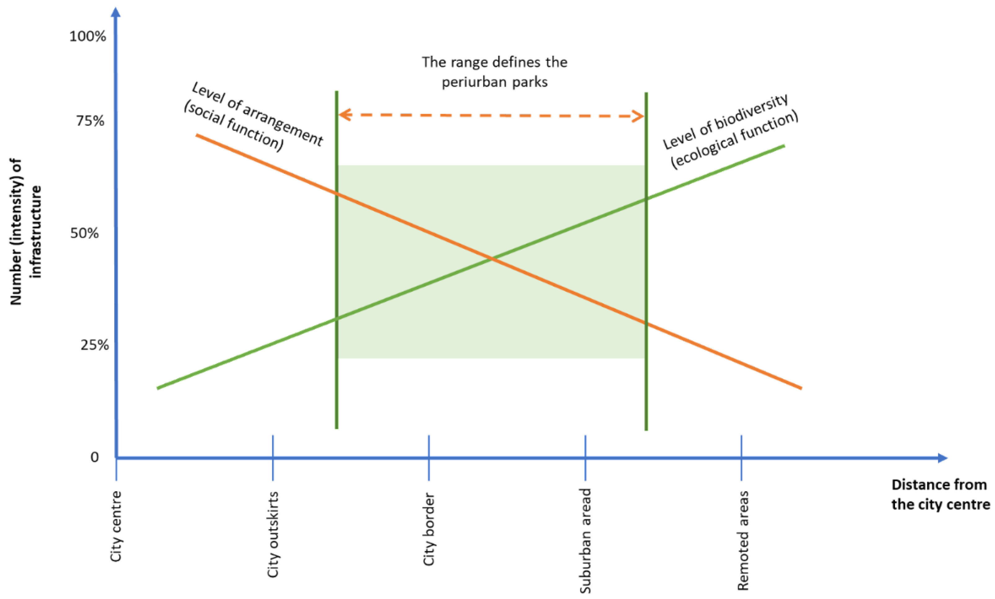
25]. France refers to the so-called ‘ancillary benefits’ of urban agriculture in terms of healing economies, connections, aesthetics, heritage, and sites and societies—in short, what might be referred to in a holistic sense as the emerging paradigm of ‘agrourbanism’. In this context, agricultural parks, in their various configurations and definitions, are considered as instruments for the spatial planning of portions of land in which agricultural production and ecological and cultural functions are combined and coordinated in an integrated manner. Periurban parks, unlike the national parks, located far away from man-made places and designated primarily for nature protection, play a mediating role between offering recreational places to a metropolitan-scale user base and maintaining biodiversity and environmental and landscape values (
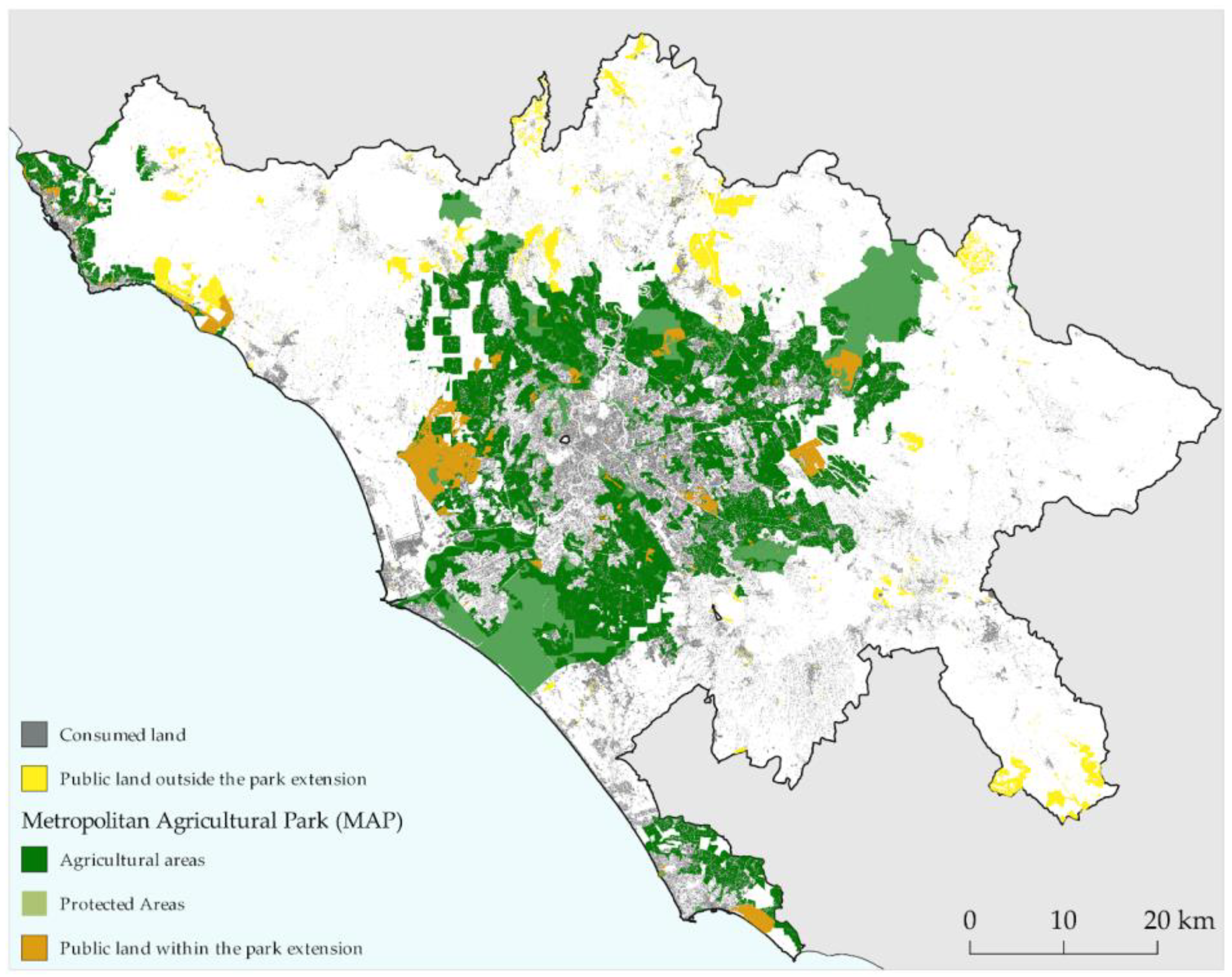
Figure 1).
The anthropocentric point of view of these parks entrusts communities and local actors with an active role of regulation and control over the territories. While human presence represents their dynamism, it also poses a threat to already fragile habitats; an institutional approach validated by shared programming/planning with bottom-up approaches is, therefore, the key. The periurban agricultural territory, as a sphere of significant locally rooted proximity economies, can, thus, assume the role of a green space suitable for the development of new forms of interaction between agricultural entrepreneurial activity, the city service system, agroenvironmental regeneration, and forms of socio-productive innovation in the rural world based on the protection and valorisation of local heritages and identities. The strategic option for the agricultural park and multifunctional agriculture is developed and based on these assumptions, referring to aspects such as the recognition of the value of periurban and proximity agriculture as an activity capable of producing and reproducing, through the development of short supply chains, a fiduciary link between production and consumption, and, at the same time, enhancing local cultural diversities and specificities; the environmental protection and the provision of ecosystem services—and their trade-offs—that the different types of landscape can fulfil for the more general improvement of the urban ecosystem (water cycle, purification, waste cycle, air quality and climate, fauna, etc.) and of the landscape quality itself [
26]; the re-territorialisation of food, understood as the territorial dynamics of agricultural settlement as a function of the evolutions in terms of social, ethical, and symbolic values that are characterising urban demand; and the improvement in the resilience of urban ecosystems, in which green infrastructures are gaining more and more recognition as a long-term measure for climate change mitigation and adaptation and the reduction in the negative impact of soil sealing due to settlement developments.
2. Agricultural Parks and Multifunctional Agriculture: A Perspective for the Metropolitan City
Agricultural parks have embodied in Europe, at least in some countries, a shared and commonly acknowledged role as a protective and active tool for the enhancement of planning in agrienvironmental, periurban areas [
27,
28], despite original arrangements in terms of spatial forms and coordination between stakeholders [
29]. The attempt to transpose periurban open space into an environmental and recreational resource, channelling multiple uses into a coherent framework, has been one of the most accomplished experiences in the case of the Grand Parc Mirabel in Lyon, among the largest periurban parks in Europe. Established in 2005, with its 2200 hectares covering sixteen municipalities, it was included in the SCOT (Schema de Coherence Territoriale) of the Lyon conurbation as an indispensable and structuring element of the new metropolitan layout, both from the point of view of biodiversity conservation and as a recreational space and production of ecosystem services for the city. The Agricultural Park of Baix Llobregat was founded in 1997 with the aim of consolidating and managing 2900 hectares of high-quality fruit and vegetable crops (open air and greenhouses) in the Llobregat delta near Barcelona and to promote professional agricultural activities in this area. The initiative emerged from a bottom-up dynamic before finding institutional recognition [
30]. The high pressure from urban and industrial expansion in Barcelona and its adjacent municipalities and the farmers’ requests for a clear and efficient solution for the preservation, development, and management of this agricultural area were the basis for the foundation of the park [
31]. In Montpellier, the Agriparc concept was first included in the local development plan (SCOT) and is now reflected in the urban area’s Agenda 21, as well as in the city’s biodiversity policy. The Agriparc has become a benchmark for integrating agriculture into urban planning and development projects. According to Jarrige and Perrin [
29], the territorial innovation has been made possible by the adaptation of the concept of agricultural park to the territory, and by its appropriation and transformation by the players with a view to territorial development. At EU level, the theme of periurban parks has been the subject of a European project, coordinated by the Region of Tuscany and financed by the INTERREG IV programme entitled ‘Periurban Parks. Improving Environmental Conditions in Suburban Areas’, which provides interesting insights into the possible diversification of the park theme, tracing completely original spatial and functional declinations. The project has applied its survey methodology to fourteen pilot areas, including the Parco della Piana in Tuscany and Parco Agricolo Sud and Parco Agricolo Nord in Milan, basing its discussion on the role of green infrastructure in the provision of ecosystem services for the city.
The first experiences of Italian agricultural parks date back to the 1990s, but it is from the beginning of the new millennium in particular that we see a greater diffusion of them supported by the growing awareness of the important role played by periurban agriculture, diversified and multifunctional, in safeguarding the quality of rural, urban and interstitial spaces. At the Italian level, although there is no national definition, the delineation and characteristics of agricultural parks are very often left to the local authorities (Regions or Municipalities). In the case of Lombardy, for example, Regional Law 86/93 defines agricultural parks as part of a broader Regional Plan of Protected Regional Areas. They are intended to maintain and enhance the typical environmental and landscape features of rural areas and their traditional natural and semi-natural values, through the protection, qualification, and enhancement of agricultural activities. In 2007, the Parco Agricolo Sud Milano (South Milan Agricultural Park) was established with the objective of protecting; restoring the landscape and environment of the connecting strips between the city and the countryside; connecting the external areas with the urban green systems, maintaining the ecological balance of the metropolitan area; safeguarding, qualifying, and enhancing agro-silvo-cultural activities, and cultural and recreational use of the environment by citizens. Nevertheless, as acknowledged by Spagnoli and Mundula [
32], in Italy, most of the parks classified as agricultural are set up on the basis of a bottom-up approach and differ “in terms of size, type and number of players involved, as well as organisation and purpose”. In Vicenza, the proposal for an Agricultural Park followed a bottom-up path involving a number of citizens’ associations and committees for the creation of a green belt around the urban area. The proposal revolves around the involvement of active farmers, the role of municipally owned public land, and the cultural functions that could be activated in a rural building in the area [
33]. The Milan and Vicenza models represent the extremes of a continuum of forms of governance that may concern Agricultural Parks. If, on the one hand, the Agricultural Park was the result of an institutionalisation process involving the Region and the Municipality, on the other hand, the Vicenza proposal represents the result of a civil society debate on the role of agricultural land and rural buildings, of a public nature, as common goods to be valorised for social purposes. In the case of the Ciaculli Agricultural Park (Palermo, Italy), there is no real managing body but only a simple control by the municipality of Palermo. For the creation of the park, agreements were made with the farmer-owners for naturalistic and landscape redevelopment [
32]. The park project was developed in the framework of European Community’s Life program in 1994 (the project was presented under the Life94 program under the name “Agricultural management model in a periurban area of Palermo”) and implemented between 1996 and 1998. The project has benefitted from the inclusion of the area within the city planning instrument and the General Regulatory Plan (PRG) formally recognized its intended use. Indeed, the aim of the project was to define a management model for a periurban agricultural area by safeguarding the traditional functions of periurban agricultural activity and, at the same time, developing new functions in response to the new demands of the contemporary city [
32].
3. Aims, Materials, and Methods
3.1. Aims and Conceptual Background
In the city of Rome, the possibility of planning a series of projects has recently opened up with the aim of reconnecting the city and the countryside while at the same time achieving various environmental, productive, social, and economic objectives. In particular, as part of the Sustainable Urban Agenda of the Metropolitan City of Rome, a Food Atlas has been developed [
34]: a mapping of the food system in its complexity, through the reorganisation, systematisation, and narration of a large amount of data. The Atlas made it possible to draw up a gap analysis, i.e., a verification of correspondence between the socio-economic phenomena of the metropolitan food system and the objectives of the 2030 Agenda and, on this basis, to indicate seven strategies for its ecological transition. Among the projects that have been hypothesised is the proposal for a Metropolitan Agricultural Park (MAP), the objective of which is the reconnection between city and country, between producers and consumers, and which is presented in this article.
In particular, the realisation of the MAP is based on an innovative methodology building on the idea of the Agricultural Park as an area in which exchanges of goods—also relational—and services, social and environmental, as well as economic, take place between the ‘countryside’ and the ‘city’, and on the concept of the 15 min city [
35]. This approach to urban planning that aims to create more sustainable, liveable, and connected cities is inspiring many cities to rethink their structure to become more people-friendly. The idea behind this concept, which gained great popularity in the wake of the COVID-19 health crisis, is the ability to meet the daily needs and activities of most residents of a neighbourhood within a 15 min walk or bicycle ride [
36]. The main difference from other approaches based on the concept of accessibility is the urban planning principle of proximity: geographical proximity, i.e., the location of people, services, and activities in close proximity to each other, is one of the main ways in which people access spatially distributed opportunities in the urban environment. In this sense, the areas of the Agricultural Park, starting from those potentially suited, were identified on the basis of the potential demand for goods and services. At the same time, a careful and georeferenced analysis of periurban agriculture made it possible to identify the areas already covered by the activity of agricultural enterprises offering proximity goods and services, specifically aimed at the urban population. The intersection of the two dimensions makes it possible to identify the uncovered areas and to intervene with spatial development and planning policies aimed at bridging the gap, which can then be implemented at a public and private level. This is, therefore, a methodological contribution, which at the same time allows the illustration of the Agricultural Park proposal followed by scientific analysis work.
3.2. Methodology
The methodological process aimed at defining the perimeter of the park can be summarised through two phases: definition of the potential area of the Agricultural Park and analysis of the flow of goods and services of the farms included in the park area.
Firstly, the park area was defined through the following methodological steps:
Collection of basic geographical data;
Definition—on the basis of agronomic and productive suitability criteria—of the areas potentially affected by the Agricultural Park project;
Definition of a margin of the most densely urbanised area and of the usable area;
Measurement of accessibility to services through topological measures;
Combination of qualitative and spatial criteria through overlay analysis techniques to determine the park area.
Secondly, an analysis of the multifunctionality of the farms included in the MAP area was conducted, which highlighted the relative types of goods and services offered. The analysis was conducted as follows:
Primary data collection on the characteristics of farms (production, marketing channels, services, and social farming projects);
Analysis of secondary data from institutional sources on the food system;
Mapping and analysis of the services offered by 15 multifunctional agricultural social farms and cooperatives in the periurban area of Rome (
Appendix A);
Conducting semi-structured interviews with representatives of multifunctional farms.
3.3. Input Data
The research exploits different types of input data, both thematically and in terms of format and spatial and temporal resolution. The National Land Consumption Map (LCM) and the CORINE Land Cover (CLC) were used as land cover and land use data. The LCM is a national-coverage 10 m resolution raster, produced and updated annually by ISPRA-SNPA for the mapping of artificial areas [
37]; the data allowed the characterization of the urban–rural continuum. The CLC belongs to the Pan-European component of the Land Monitoring Service of the Copernicus Programme and provides a 44-class land cover and land use map with geometric detail of 25 hectares; through the CLC it was possible to identify the main agricultural areas. To evaluate the quality of the agricultural areas, the Regional Agency for the Agricultural Development and Innovation of Lazio (ARSIAL) cartographic database relating to the 2019 land use capabilities at a scale of 1:250,000 was used, which identifies the soil’s ability to support agricultural production without degrading. The classification defines eight classes, ordered by increasing levels of limitations; in this study the areas in which classes I to IV prevail (soils suitable for agricultural activity) have been considered [
38]. The supply of goods and services related to periurban agriculture was characterised using the data collected in the context of the “Food Atlas’’ of the metropolitan city of Rome, such as: the list of real estate properties declared by the Public Administrations of the Treasury Department of the Ministry of Economy and Finance for the year 2018, the agrofood information of ARSIAL 2015 on quality branded productions (PDO, PGI, etc.), the data on the food districts of the Latium, the georeferenced list of the sales, and distribution points of the Alternative Food Networks, farmers’ markets, farms, and third-sector organisations involved in social farming projects. Finally, to evaluate the catchment area that has access to agricultural areas of high productive value and related activities, the global dataset of the Global Human Settlement Population Grid (GHS-POP)was used, related to 2015 and with a spatial resolution of 250 m.
The elaborations were carried out with the aid of QGis Open Source gis software (V 3.28.11 LTR) with reference to the area of the Metropolitan City of Rome Capital.
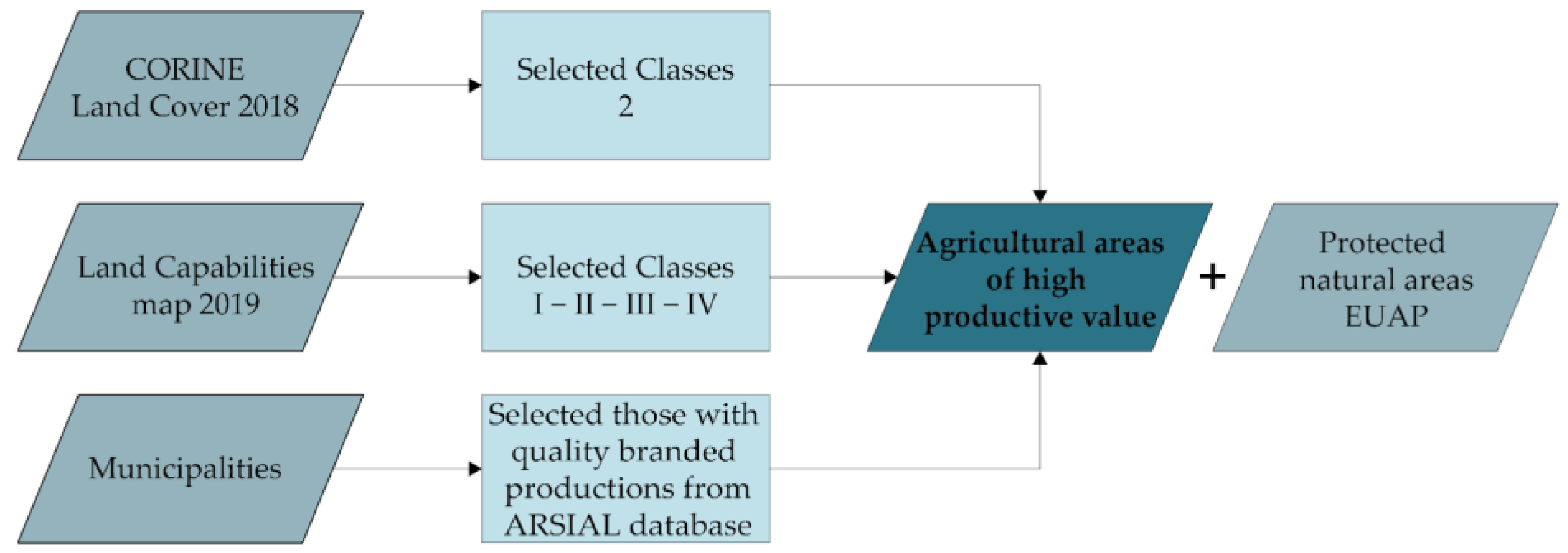
3.4. Identification of Agricultural Areas of High Productive Value
The first phase of the research concerned the identification of agricultural areas with characteristics suitable for hosting valuable agricultural activities and consolidated agrifood chains (
Figure 2):
First of all, the agricultural areas have been identified, considering the CLC class “Agricultural areas”. Among CLC agricultural areas, those with the most suitable characteristics for hosting production activities were selected, using the ARSIAL database relating to land use capability. The selected areas belonging to the Metropolitan City of Rome municipalities with consolidated high-quality agrifood productions were selected, using municipal data on typical productions and data on food districts. Finally, protected areas have been identified, which in a network strategy can reconfigure periurban natural spaces in an innovative and multifunctional way, assuming the role of stable elements of ecological connection.
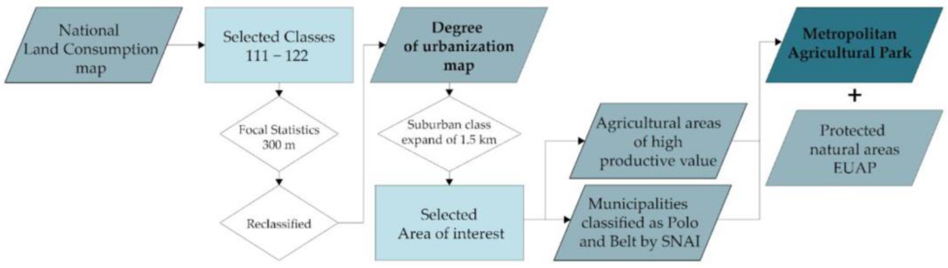
3.5. Delimitation of Accessible Agricultural Areas with Respect to the Degree of Urbanisation
The agricultural areas of high productive value previously identified are related to the urban areas, in order to identify an area close to the dense urban fabric with valuable agri environmental characteristics, suitable for exchanging functions and relationships between the city and the rural area (
Figure 3).
To define the settlement forms that describe the “urban countryside” and identify the urban fringe area, the urbanisation classification methodology developed by ISPRA-SNPA and based on the LCM was adopted. Starting from the LCM, the areas classified as “buildings”, “construction sites”, and other “clay areas” were selected. The LCM classes of roads, port and airport infrastructures, other undeveloped impermeable areas, greenhouses, landfills, mining areas, quarries, and photovoltaic fields have been excluded. For each cell of the LCM raster, the average density of artificial surfaces in a radius of 300 m was calculated. Areas with an average density higher than 50% were classified as “urban”, those with a density lower than 10% as “rural”, and the rest as “suburban”.
Once the boundaries between urban, periurban, and rural areas had been defined, the accessibility of agricultural areas of high productive value was analysed, understood as the ability to reach a place, a function, or a service quickly and cheaply. A belt has been defined around the urban mosaic, called the “green ring”, in which the most-accessible agricultural areas have been included. To be accessible, they must respect a spatial and temporal proximity criterion based on the “15 min city” model (i.e., an area is “accessible” if it can be reached within a 15 min walk, equal to about 1.5 km). The green ring was, therefore, defined on the border between the “Suburban” and “Rural” classes, making a buffer of 1.5 km on the rural class and considering the agricultural areas that fell within it. In the green ring, only the portion of territory that fell into the municipalities classified as “Pole” and “Belt” by the National Internal Areas Strategy (SNAI) was finally selected.
3.6. Proximity of Farms and Related Commercial Activities in the Metropolitan Agricultural Park and in the Urban Area
Within the green ring and the urban area, the accessibility of farms and third-sector entities involved in social farming projects, farmers’ markets, and Alternative Food Networks was assessed. These subjects were identified by geocoding the addresses of the “ARSIAL-Regione Lazio” [
38], “Social and Solidarity Economy Network (RESS) Rome” [
39], and “Alveare che Dice Si!” databases [
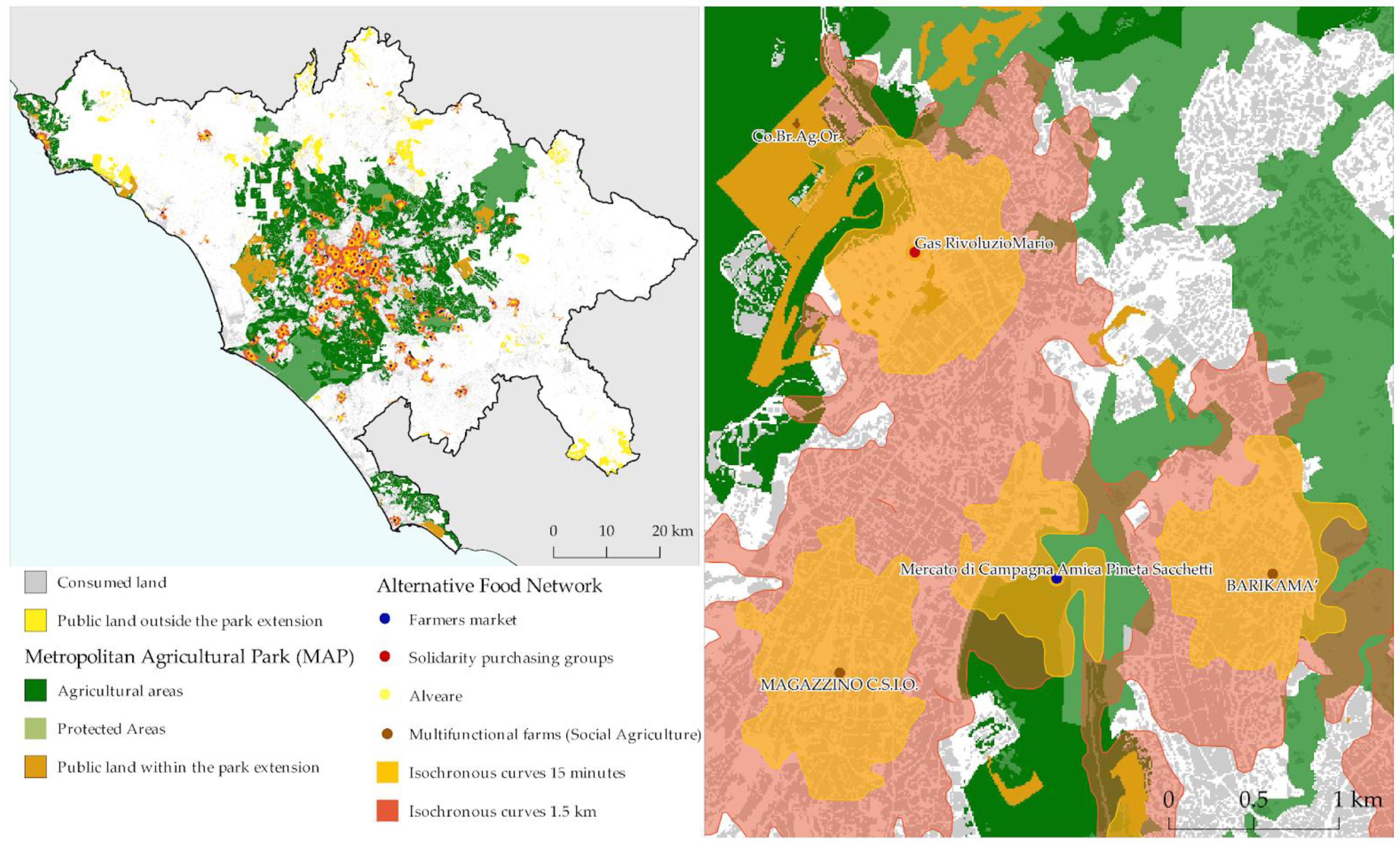
40]. Accessibility was assessed using isochronous curves, i.e., curves in which the points are equidistant in terms of travel times from one point to another, with reference to a given travel method. The isochrones delimit the area of influence of the services and the relative catchment area, considering a 15 min walk on the most efficient route. In particular, the QGis Open Root Service plugin was used, and the catchment areas were defined using the GHS population grid (GHS-POP) data.
4. Results
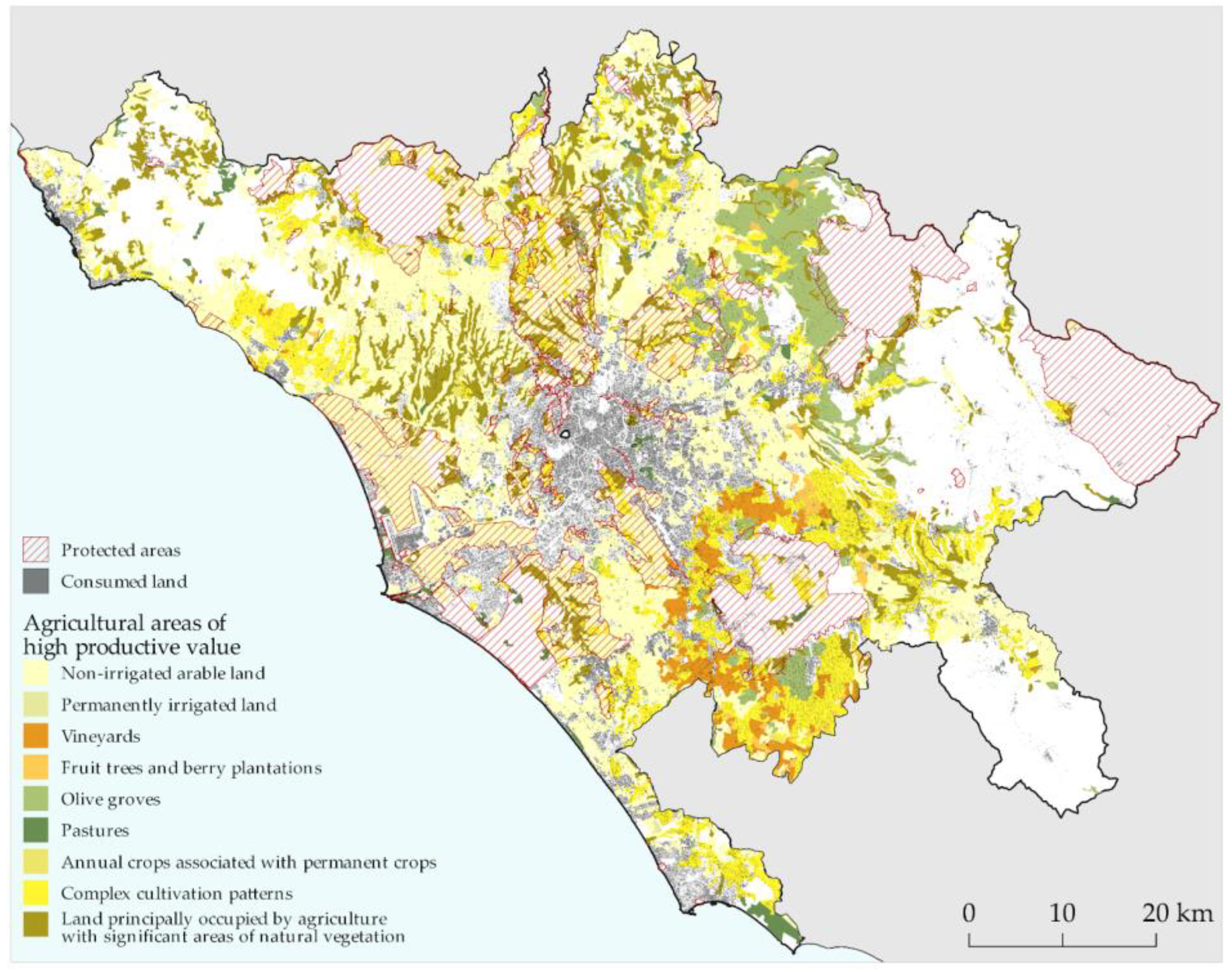
The first operation carried out for the identification of the agricultural park involved the CLC, the ARSIAL land use capability database, and the list of municipalities of the Metropolitan City of Rome with consolidated high-quality agrifood productions (
Figure 4). The results of
Table 1 derive from the union of the three datasets and indicate 237,952 hectares which fall within the municipalities with consolidated high-quality agrifood productions and which are classified as “Agricultural areas” by the CLC and as “Soils suitable for agriculture” by ARSIAL. In subsequent analyses, these areas will be referred to as “agricultural land suitable for agriculture”.
The accessible areas have been identified through a “buffer zone” of 1.5 km of the urban and suburban areas starting from the classification of the urban–rural continuum proposed by ISPRA (
Table 2). These areas occupy 354.048 hectares, equal to 66.12% of the surface area of the Metropolitan City of Rome. Considering the “agricultural land suitable for agriculture” that fall within the “buffer zone”, 181,507 hectares were identified, from which those that fell within belt or pole municipalities were further selected, for a total of 91,656. Of these, 9.674 hectares are publicly owned (
Figure 5).
Finally, the accessibility of farms and third-sector entities involved in social farming projects, farmers’ markets, and Alternative Food Networks was assessed (
Figure 6). Considering the accessibility with respect to isochronous curves at 15 min, 11,088 hectares are served, making it possible to reach 998,061 people. Considering instead the territory and the population served by the activities within a radius of 1.5 km, 25,235 hectares of land are involved, reaching over 1.8 million inhabitants (
Table 3).
Analysis of Multifunctionality in the 19 Municipalities of the Park Area—Supply of Goods and Services of Periurban Agriculture
The MAP proposal has two main objectives: the enhancement of the presence of multifunctional farms and the strengthening of the relationship between these farms and the populations of the municipalities in which they are located. These relations are based on a deep interdependence based on the exchange of goods and services produced by farms or made possible by them. In this section we present a brief analysis of the multifunctionality characteristics of farms in the 19 municipalities included in the park area, which reviews the types of goods and services that farms offer to the populations of the park area. According to our categorisation, these can be traced to four categories of multifunctionality: supply of fresh and processed foodstuffs; marketing and direct sales services; tourism and recreational services; and services of social interest.
Table 4 shows some key facts for each of the identified categories.
The area of the 19 municipalities identified by the MAP has a consolidated agrifood tradition and a recognised character given the widespread and consistent presence of 6.546 productive farms that contribute to and guarantee the supply of local food products. Among the municipalities involved, as shown by the latest ‘Census of Agriculture’ of the National Institute of Statistics (Istat) in 2010 [
41], Rome is the one that concentrates production the most with a total of 2656 farms.
Consulting various censuses and portals on Lazio’s agrifood production, such as [
42] Qualigeo, the report [
43] ‘Lazio Patrimonio Agroalimentare—Tra Biodiversità e Tradizione’, and the portal Parchi Lazio [
44], a quantitative and spatial analysis of the most important productions was carried out. Of primary importance is the production of typical products and flavours in all the main food chains: cereal, horticulture, fruit, olive, wine, meat, and dairy, with quality-certified products (these include four PDO-certified products: Sabina Extra Virgin Olive Oil, Gaeta Olive PDO, Mozzarella di Bufala Campana PDO, and Ricotta di Bufala Campana PDO; Salamini Italiani alla Cacciatora PDO, Pecorino Romano PDO, and Ricotta Romana PDO are produced throughout the region. Two PGI-certified products, Carciofo Romanesco del Lazio IGP and Kiwi di Latina IGP to which Abbacchio Romano IGP and Agnello del Centro Italia IGP are added, are produced in the entire regional territory. Finally, the area under analysis is recognised for wine production with eleven PDO wines and two PGI productions covering the entire metropolitan area: Costa Etrusco Romana PGI and Lazio PGI). In addition, already in 2010, 133 farms had obtained organic production certification, many of them in the Municipality of Rome (100). Although a minority, this presence confirms the availability of natural and untreated products, which undergo fewer steps from producer to consumer than fruit and vegetables, fresh eggs, and more. This brief review highlights the relevance of the agrifood tradition of the 19 municipalities for all the main production chains. In particular, the Municipality of Rome absorbs almost all organic productions and typical products and flavours from the fruit, meat, and dairy chain. On the other hand, olive and wine productions are the most widespread productions within the agricultural park area covered by this research.
The second category of services refers to the marketing of fresh and processed agricultural products and, in particular, to direct sales channels. The multifunctional farms in the 19 municipalities offer the possibility for consumers to buy products at the farm premises: according to ISTAT 2010 data, 24% of farms market part of their production through this channel. At the same time, direct sales are made possible by the widespread presence of farmers’ markets in the MAP area. In particular, there are 29 farmers’ markets, 20 of which are concentrated in the Municipality of Rome. These markets are organised by actors representing producers as in the case of the Campagna Amica Foundation—Coldiretti (e.g., Campagna Amica Market Circo Massimo in Rome’s Municipality, Campagna Amica Market Tiburtino Market in the eastern suburbs of the capital), on the initiative of groups of producers (e.g., Farmers’ Market of Rome and the Castelli Romani) or farmers’ movements (Farmers’ Market Terra/Terra). On the one hand, farmers’ markets represent an important marketing channel for local businesses; on the other hand, they allow consumers to get in touch with local producers by enhancing local supply chains in their consumption choices. Moreover, periurban farms are included in Alternative Food Networks (AFN) circuits to which they supply fresh and processed products. In the 19 municipalities considered, we found a widespread presence of AFN circuit actors who are supplied by numerous local companies. Among them we find 61 solidarity purchasing groups connected with solidarity economy networks (Social and Solidarity Economy Network—RESS Roma) and entrepreneurial initiatives in the distribution sector (e.g., Zolle, Alveare che Dice Si!).
The third category includes a type of service inspired by the criterion of multifunctionality in agriculture: tourist hospitality in agritourism. This type of business caters to two types of users: Italian and foreign tourists who choose non-hotel structures to spend their holiday periods in; and the population of the Rome urban area, especially on weekends or on national holidays. In the Rome metropolitan area, Istat surveyed 316 agritourism farms in 2020, showing the constant growth of the sector with an increase in the number of companies of 67% in the period 2010–2020. In the pre-pandemic year 2019, agritourism in the Rome metropolitan area attracted around 40,000 guests; however, the pandemic in 2020 saw a 63% reduction in the number of guests (14,190). Although this is a small share compared to the total number of tourist flows reaching the Rome area, agritourism includes farms that allow urban populations to have direct use of periurban areas both in the context of food and wine tourism and recreational and leisure activities. In particular, in the 19 municipalities there are 96 agritourism farms, of which 58 offer overnight accommodation to customers, 64 offer catering services, and 25 offer fresh produce tasting and processing. Among the agritourism farms, 55 of them offer recreational activities to customers—sports (e.g., horse riding and trekking), nature, or educational (Educational Farms).
The fourth category encompasses the fourth type of services that farms provide to urban populations: social services of general interest. These services are provided by farms involved in social farming projects, which have a widespread presence in the area identified for the proposed agricultural parks. On the one hand, farms and agricultural cooperatives organise social farming projects; on the other hand, farms offer the possibility for associations and third-sector organisations to carry out their activities on the farm premises. Social services of general interest provided by farms are aimed at the most vulnerable groups for which social inclusion and solidarity projects are designed. These include labour inclusion projects for categories with low-employability such as the mentally or physically disabled, ex-offenders, and drug addicts. At the same time, the inclusion of migrants is one of the priority themes of the social farming projects in the Rome metropolitan area. Farms can, thus, be garrisons of legality that counteract the phenomenon of ‘caporalato’. Moreover, farms and agricultural cooperatives organise training courses for Italian and foreign Erasmus students and young people on the acquisition of working skills in agriculture.
5. Discussion and Conclusions
This article proposes a new methodological approach to the definition of agricultural parks, which follows the principle of proximity and considers the flows of both social and environmental services that can be enjoyed in these areas.
Firstly, this approach paves the way for new research, especially regarding the social acceptance [
29] and the technical feasibility of the MAP proposal; on the other hand, it includes some limitations mainly due to the eminently theoretical and descriptive approach of the analysis. The results of the analysis led to the proposed Metropolitan Agricultural Park (MAP), which would include 19 municipalities out of the total 121 of the Metropolitan City of Rome, based on the identification of a periurban agricultural area of Rome. The area of the MAP proposal identifies a territory in which to enhance the presence of farms and protect periurban agriculture from competition for alternative land uses and from the processes of speculation linked to land ownership [
3]; on the other hand, the area of the MAP proposal is the outcome of a methodological path that combines data on goods and services of multifunctional agriculture and the concept of proximity, according to the conceptualisation of the 15 min city.
The analysis of the multifunctionality of farms in the MAP area highlighted the elements of the relationship between farms in the Rome periurban area and its neighbourhoods. As illustrated in the previous section, these elements include the provision of goods and services that meet people’s material/primary and intangible/social needs. This condition is particularly evident in the case of multifunctional farms, which combine a productive utility with objectives of environmental protection, business diversification, and provision of services to fragile population groups, thus pursuing equi-genic aims [
23,
45]. With this in mind,
Appendix A shows the main services for the four categories considered provided by 12 multifunctional farms included in the periurban area analysed in this paper. Although relatively few in number, the multifunctional farms surveyed and analysed show a deep-rooted connection with the metropolitan population based not exclusively on food supply. The services of social interest provided by the metropolitan farms analysed can be seen as examples of implementing the interpretation of farms as welfare service providers according to National Law No. 141 of 18 August 2015 [
46]. Therefore, it is considered appropriate to enhance the role, visibility, and action of multifunctional farms for their already well-known potential in providing community-oriented social services in rural and periurban areas, including health services, educational, and recreational activities, and the inclusion of people with mental, social, or physical disadvantages [
47]. On the other hand, multifunctional farms in the periurban area analysed are key suppliers for Alternative Food Networks of Rome, where local food networks play a remarkable role [
48], particularly in building trusting relationships between consumers and producers. Furthermore, according to Gargano et al. [
49], multifunctional farms can be considered frontrunners of the agroecological approaches of European strategies and policies—Green Deal, Strategy for Biodiversity, Action for Climate, and Farm to Fork—for the agricultural sector.
The MAP proposal was drawn up as one of the main outputs of the process of constructing the Food Atlas of the Metropolitan City of Rome [
34]. In this way, the MAP proposal represents one of the possible projects of the new season of territorial planning on a metropolitan scale in Rome. The MAP proposal aspires to contribute to the experiments and the innovative place-based approaches in the construction of new forms of governance of periurban agricultural areas. Moreover, the MAP represents a possible solution to achieve policy objectives for the environmental, economic, and social sustainability of the metropolitan food system whose characteristics and trends have been analysed in the Food Atlas [
34]. In particular, the MAP project aims to: (i) Enhance and strengthen the role of periurban multifunctional agriculture in terms of environmental and social and economic services; (ii) Halt environmental degradation due to constant settlement pressure that tends to fragment natural areas and saturate valuable urban ‘voids’; (iii) Protect soil and counteract its consumption; (iv) Connect the protected natural areas, which are present in a diffuse manner around Rome’s dense urban core; (v) Create a governance structure to make the local food economic system more competitive. These objectives are coherent with Fanfani’s call for the integration of planning practices, as well as design initiatives for the enhancement of prime farmland and biodiversity protection, settlement resilience, and locally integrated endogenous development [
27].
In this perspective, periurban agricultural parks emerge as an instrument of primary importance for combating fragmentation and land competition in periurban areas, initiating development processes leveraging on a variety of sustainable activities ranging from agriculture to tourism and leisure [
32]. Furthermore, it is essential to include the activation of participatory processes and collaboration with the various local actors, both to define priority objectives and to build a sense of identity. The inhabitants and farmers operating within the periurban agricultural park ought to be the main promoters of the project. If they do not feel involved in the process and if they do not perceive the place as an integral part of themselves, any activity or initiative will risk failure or opposition, especially from farmers, which mainly relates to a ‘defensive’ idea of the park concept [
27]. Accordingly, Marino et al. [
50] demonstrated that the planning of urban and periurban agricultural areas should rely on tools capable of integrating both spatial mapping methods and human-based assessment methodologies.
In conclusion, the idea behind the proposal for a metropolitan agricultural park is based on the possibility of connecting with each other and with other urban and semi-natural green spaces (parks, gardens, urban gardens, and urban forests). Taken together, these lots constitute a “green infrastructure” and may be the result of a spatially planned network [
51] but sometimes also the result of an unplanned evolution, due to economic and social phenomena of abandonment and/or innovation in the agricultural sector and also in residential dynamics. Often these “spontaneous” green infrastructures are already able to provide flows of ecosystem services including quality food and the possibility of using green spaces for recreational purposes, as well as a venue for social services. The work presented here underscores the importance of urban planning in maximising the positive impacts of green spaces on both people and the environment. Enhancing the quantity and quality of green spaces in cities not only diversifies the services available to citizens but is also a vital component of the array of policies required for a shift towards sustainable development. This significance stems not only from the environmental benefits but also from the social implications, particularly on health and addressing disparities, all while advancing the cause of climate justice.
This methodology opens up further spaces for future research developments and is, therefore, a starting point to increase, through appropriate integrated planning paths [
34], the accessibility of agricultural areas and, more generally, of public open spaces within the mosaic of urban green infrastructures. This strategy also responds to the objectives of the 2030 Agenda, particularly targets 11.2, 11.3., and is, therefore, functional to the achievement of the Sustainable Development Goals. Additionally, the planning of the MAP could also be integrated with other sectoral policies such as agriculture (Common Agricultural Policy, Rural Development Plans, etc.) and climate adaptation (Urban Climate Adaptation Plans) but also social policies by thinking about the proximity services that these areas can provide. This “expansion” of functions for the areas of the MAP can benefit in the planning phase of methodologies that integrate the opinion of experts and the indications coming from civil society, also through participatory and inclusive processes with the third sector. This seems to us to be one of the frontiers that research and politics can face together in the near future.


 ,
, 


