Abstract
It has been a century since the Great Kanto earthquake and 78 years since WWII, both of which were catastrophic events in Japan’s history. Preserving memories of urban disasters is essential for preventing future tragedies, and while survivors’ testimonies hold great power, their numbers dwindle over time. However, trees which bear the scars of disaster can also serve as valuable storytellers. This study investigates earthquake and war-damaged trees, including 11 Gingo trees, 1 Chinquapin, and 1 Japanese nutmeg tree, located at the Yushima Seido Temple in Tokyo, and highlights their importance in preserving memories. The trees were measured using a sonic tomography tree internal diagnosis device, resulting in a total of 41 cross-sections that captured their conditions in images. The results indicated an ideal measurement method for trees located on slopes, as well as identifying a new type of classification shape for measurement cross-sections. The results of this research should primarily be of benefit to tree owners, but it is hoped that the benefits can also extend to a wider audience by increasing awareness about the significance of trees with unique urban historical narratives, aiding the preservation of urban green space, aiding in disaster preparedness, and promoting the role of such tress in peace education.
1. Introduction
It has been 100 years since the Great Kanto earthquake struck the modern Tokyo metropolitan area on 1 September 1923, and 78 years have passed since the end of World War II in August 1945. In order to prevent the recurrence of such tragedies and ensure the transmission of the memories of urban disasters caused by natural and human factors to future generations, reflection and examination from various perspectives are essential.
In the context of this transmission, the words spoken by the survivors themselves hold great persuasive power and are a highly effective means. However, as time passes from the occurrence of these events, the aging of individuals poses a significant barrier to this transmission. In both the Great Kanto Earthquake and the wartime devastation, many of the firsthand witnesses who could directly convey the horrors of those times to us, the storytellers, have since passed away.
Due to factors such as the influence of housing policies implemented shortly after the war [1] and the societal conditions that led to a rapid economic growth period approximately five years into the reconstruction phase, Japanese cities have undergone significant transformations, with buildings rarely remaining in the same place for extended periods [2]. Therefore, there are very few structures that preserve the memories of either the war or the Great Kanto earthquake. However, while we continue to lose direct connections to the individuals, relationships, and external environments related to the memories of these events, the presence of the surviving trees that bear the scars of disaster on their trunks and branches can serve as a valuable contribution to addressing the issue of memory transmission.
In this study, trees that were damaged by natural disasters such as the Great Kanto earthquake are referred to as “earthquake-damaged trees”, while trees in Japan damaged by military attacks during World War II are referred to as “war-damaged trees”. Furthermore, trees that were affected by the atomic bombs dropped on Hiroshima on 6 August, and Nagasaki on 9 August 1945, are classified as “atomic bomb-damaged trees”.
There has been limited research worldwide on trees displaying memories of disasters and wars. However, an example comes from near a small village in Poland, where there is a woodland that contains beech trees with inscriptions on the bark left by prisoners of war who were digging in the woodland. These trees, which continue to survive, are being investigated as historical preservation subjects through an archaeological approach [3].
Also, in the city of Guernica, Spain, the “Guernica Tree (Arbol de Gernika)” was damaged during the German bombing in 1937 and is currently preserved in the garden of the Basque Parliament. Although the original tree has decayed, it is still possible to confirm the damage that remains on its trunk [4]. In Hildesheim, Germany, there is an approximately 1000-year-old dog rose (Rosa canina) growing on the wall in the courtyard of the apse of St. Mary’s Cathedral. The cathedral was destroyed in 1945 by Allied bombing, but the roots of the rose tree survived, and it is said to have bloomed again amidst the ruins. This rose tree, said to have sprouted after the war, is referred to as the “Tausendjähriger Rosenstock” in German [5]. Additionally, there has been individual interest in trees believed to be war-damaged in the aftermath of the Dresden bombings in Germany, with mentions of such trees drawing attention online from individuals with an interest in trees [6]. There are also descriptions of war-damaged trees existing within the premises of the former Potsdam Cemetery, which was affected by the Potsdam bombings [7]. However, to date, there has been no scholarly research that has systematically examined each damaged tree, seeking to explore their conservation and utilization.
Research on the post-war reconstruction of urban forests in both Tokyo, affected by incendiary bombings, and Hiroshima, devastated by the atomic bomb, has focused on a comparative examination of the impact of destructive bombings on the urban forest composition and structure of both cities [8]. This study primarily emphasizes urban planning and urban forestry and does not specifically mention the memories held by the individual surviving trees. The urban tree populations affected by the Hamburg and Dresden bombings have also been assessed by Stilgenbauer et al. [9]. In more recent conflicts, the war-damaged trees in urban and suburban forests around the capital of Bosnia and Herzegovina, Sarajevo, severely impacted by the early 1990s Bosnian War, were detailed by Laćan et al. [10]. However, these studies mainly focused on the role of post-war reconstruction of urban forests after wartime rather than conducting investigations or discussing conservation and utilization of individual trees. Similarly, studies of trees damaged by man-made disasters, such as radiation-exposed trees in the vicinity of Pripyat following the Chernobyl nuclear power plant accident, also tend to focus on the entire urban forest rather than individual trees [11]. In Kåfjord, Norway, traces of war-damaged trees can be observed. These trees were affected by the chemical substances used in a smoke screen to protect the German Navy’s largest battleship, Tirpitz, from aerial bombardment during World War II. The chemicals from this smoke screen were absorbed by the surface of the trees and were later detected using dendrochronology, a method of dating based on tree rings. However, it is important to note that this research extends beyond individual trees and includes a comparative study with the broader forest ecosystem rather than focusing solely on individual trees [12].
In Australia, there are numerous “Avenues of Honour” that have been established as public memorials for military service, commemorating the Boer War, World War I, World War II, and subsequent conflicts [13], as well as memorials like the Remembrance Driveway at the Australian War Memorial in Canberra [14]. While these avenues play a crucial role in recalling the memories of wars, it is important to note that the trees within them may not have directly suffered from the conflicts or retained damage from that time.
Therefore, this current study focuses on trees that can directly evoke memories of the conditions they experienced during the events, such as war-related damage and the intensity of fires.
The Great Kanto earthquake, which occurred at approximately noon on 1 September 1923, resulted in extensive damage, particularly in the former 15 districts of Tokyo, which correspond to the current central Tokyo area including the area inside the Yamanote Line as well as both banks of the Sumida River. Approximately 166,000 houses were destroyed by fires caused by the earthquake, and it is estimated that the death toll due to these fires exceeded 100,000 [15,16]. Currently, there does not appear to be any research focused on the trees damaged by earthquake-related fires, including the assessment of damage conditions and individual tree data acquisition.
Another well-known event that caused significant damage is the dropping of the atomic bombs on Hiroshima and Nagasaki on 6 and 9 August 1945, respectively, which has been widely acknowledged and reported by international organizations such as the United Nations [17,18]. Studies on atomic-bombed trees have been conducted, notably by Owaki et al. [19,20]. However, less well known is the significant damage to cities across Japan caused by United States military air raids during the war. In particular, during the Tokyo air raids from 9–10 March 1945, it is estimated that more than 100,000 people lost their lives in a single night [21]. Many of the trees that survived bear external characteristics on their trunks and branches such as scorching, hollowing, tilting, and other features caused by the incendiary bombs dropped during these air raids. Surprisingly, despite Tokyo being one of Japan’s most rapidly evolving cities in terms of demolition and construction, there are still over 200 these “war-damaged trees” surviving within the 23 wards of Tokyo alone [22].
Negishi et al. [23] and Kanno et al. [24] assessed trees in the eastern area of Tokyo, including Taito Ward, Sumida Ward, and Koto Ward, that were damaged during these air raids. They clarified the morphological characteristics, current status, and criteria for identifying such war-damaged trees. Furthermore, Kanno et al. [22] conducted expanded research to cover all 23 wards of Tokyo, summarizing the distribution characteristics of war-damaged trees affected by a total of five nighttime air raids occurring from March to May of the same year. They pointed out the historical value of these trees as “storytellers” of wartime history.
The Visual Tree Assessment (VTA) method developed by Mattheck et al. [25] is widely used for tree diagnosis. Trees have the ability to mechanically reinforce themselves when internal issues such as decay, cavities, cracks, or healing from injuries occur. Severe decay can also lead to passive deformation. The VTA method initially involves a visual assessment or the use of simple tools to roughly assess the extent of internal defects, decay, or other issues based on various external characteristics. Subsequently, more detailed diagnostics are obtained using equipment, allowing for objective assessments. However, as noted by Hori [26], “VTA technology can be improved through training, but it is currently almost impossible to accurately judge and predict the seriousness of defects, whether they will lead to breakage, and if so, when that breakage will occur”. Hori also emphasizes that “accurate diagnosis is a prerequisite for developing strategies, such as treatments, for trees that have suffered from decline, injury, or decay. While a certain level of diagnosis is possible through visual observation and the use of simple tools, obtaining numerical data for comparison and detecting hidden decay or cavities, especially in the case of decay, requires appropriate equipment” [26].
It has been observed that tree owners and managers with limited knowledge of trees often perceive trees as “unmanageable nuisances” due to factors such as leaf litter, overgrown branches, or concerns related to neighbor relations and land utilization. Consequently, these trees are sometimes cut down. Ensuring the conservation of trees, not only earthquake-damaged and war-damaged trees, but also all trees, begins with stimulating the interest of tree owners and managers. The cost of maintaining and managing trees increases as they grow larger, and it can be a significant financial commitment. While some municipalities offer grants for maintaining a green environment, these funds are often insufficient to fully cover the costs. Given that we must rely on the goodwill of tree owners and managers, it becomes crucial to educate them about the extent of the impact that the external characteristics of earthquake-damaged and war-damaged trees have on the trees themselves. By correctly understanding this impact, we can present tree owners and managers with strategies for the long-term conservation and management of trees, centered around a more informed perspective. This is essential for ensuring the continued preservation of these valuable trees.
Many war-damaged trees, often found in temples and shrines [22] that are frequently visited by worshippers, are owned and managed by these religious institutions. Due to the existing external visible damage to these trees [22], it is crucial to accurately assess how such damage might affect the future management and growth of the trees in order to prevent unforeseen incidents such as tree falls that can cause harm to people.
Negishi et al. [27] conducted an investigation at the Tobiki-Inari Shrine in Sumida Ward, which suffered damage during the Tokyo Air Raid, and demonstrated the feasibility of non-destructive decay diagnosis using a sonic tomography tree internal diagnosis device for war-damaged trees. This device is commonly used in tree diagnosis for public parks, street trees, and memorial trees in Japan to gain insight into the internal conditions of damaged trees. The study also shed light on potential new approaches for providing information to tree owners and managers. However, there is still a need for a more comprehensive understanding of tree internal diagnoses. A larger number of cases, encompassing diverse tree species, damage conditions, and environmental settings, would contribute to more accurate diagnostics. Furthermore, while the study by Negishi et al. [27] focused on trees with fire damage caused by incendiary bombs, there has been no investigation into the trees damaged during the 1923 Great Kanto earthquake, which also experienced fire damage. Thus, research on earthquake-damaged trees and the assessment of trees affected by both earthquake and war-related disasters remains unexplored.
Various studies have been carried out to assess trees damaged by fire. For example, studies by Maeda et al. [28] and Hasegawa et al. [29] highlighted that trees that have survived fire damage exhibit accelerated decay and discoloration based on the shape and decay conditions of their trunks, even 5–7 years after the fire damage. However, these studies focused on sugi (Japanese cedar) artificial forests with an age range of only 18–21 years, and not on older urban trees encompassing diverse species. Furthermore, the internal condition of the damaged trees in their studies was confirmed by sectioning through felling, and not by the non-destructive internal decay diagnosis that would be necessary for preserving memorial trees. This is true of many other studies of trees damaged by fire, such as [30,31], all of which employed the method of felling and extracting sections to confirm tree rings and other details. Therefore, while these studies can provide insights into the process of damage generation due to fire, they cannot be used to identify fire damage in specific trees that need to be preserved.
Possible non-destructive diagnosis methods for calculating tree decay and cavity rates include tree internal decay diagnosis devices such as acoustic tomography, lateral impact resonance methods (such as Dr. Woods, PICUS, and Arborsonic 3D), and gamma-ray transmission dose detection. Studies on the suitability of these methods have been conducted by various researchers including Tokue et al. [32], Hashiya et al. [33], and Nikaido et al. [34]. When using these devices, it is suggested to consider the shape of decay, because the evaluation of decay and cavities can be influenced by the shape of the decay. In particular, Yamashita et al. [35] pointed out that while acoustic tomography can provide relatively accurate results when there is a moderately large circular cavity in the center, it can be less accurate when assessing other cavity shapes. For example, there is a tendency to overestimate decay for slotted cavities in the central part of the tree or crescent-shaped cavities created by edge decay. Also, there is a tendency to underestimate the damage of slotted cavities near the outer edge. Furthermore, none of these studies have specifically addressed internal decay diagnosis under the recognition that the trees are war-damaged, meaning that there is no comprehensive diagnostic record.
Therefore, the aim of the current study is to obtain a diagnostic record of both war and earthquake fire-damaged trees in central Tokyo and to develop methods to improve the accuracy of tree internal diagnosis using sonic tomography. To this end, a survey was conducted of trees at the Yushima Seido Temple in Tokyo’s Bunkyo Ward that bear the marks of both the Great Kanto Earthquake and the Tokyo air raids. The coexistence of earthquake-damaged and war-damaged trees on the same site is a remarkable and invaluable phenomenon. A sonic tomography tree internal diagnosis device was employed to elucidate the specific impact of damage on 11 earthquake and war-damaged trees, as well as on two earthquake-damaged trees located at the Yushima Seido Temple. This study also aimed to achieve a three-dimensional understanding of tree internal structures by imaging multiple cross-sections, thereby enhancing the accuracy of tree internal diagnosis. This research should not only contribute to raising awareness among owners and managers about tree preservation but also foster a deeper understanding of the intricate relationship between historical events and trees.
2. Materials and Methods
2.1. Target Area and Trees
A total of 13 disaster-affected trees, affected by earthquakes and war, located within the Yushima Seido Temple in Bunkyo Ward, Tokyo, were the subjects of this study (Figure 1 and Figure 2). The Yushima Seido Temple was established in 1690 as an educational institution by Tokugawa Tsunayoshi, the fifth shogun, and in 1922, the temple grounds were designated as a national historic site. Following the Great Kanto earthquake in 1923, which resulted in a fire that consumed the entire temple except for the Nyutoku-mon Gate and the Holy Fountain, the temple underwent reconstruction in 1935, including the construction of the Taisei-den [36,37].
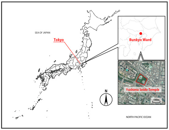
Figure 1.
Location map of Yushima Seido Temple. Source: Negishi, T. (Based on Geospatial Information Authority of Japan).
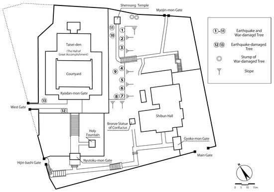
Figure 2.
Map of the surveyed trees at the Yushima Seido Temple. Source: Negishi, T.
During the Tokyo Great Air Raid on 9 March 1945, there were eyewitness accounts of incendiary bombs falling in the Shennong Temple area, resulting in the burning of a large ginkgo tree [38]. Additionally, there are records indicating that on 13 April 1945, during another air raid on Tokyo, a portion of the Nyutoku-mon Gate’s wall and the Holy Fountain were destroyed [37]. Evidence of incendiary bombs damaging the roof of the Gyoko-mon Gate and the walls near the Main Gate still exists today.
Among the target trees, tree nos. 1 to 11 are clustered in the Shennong Temple area and have been affected by both the Great Kanto Earthquake and the Tokyo Great Air Raid. Tree nos. 12 and 13 are located in front of the Kyodan-mon Gate near the west gate and have only been affected by the Great Kanto earthquake. Pruning has not been conducted in the past three years.
The reason for selecting these trees was that they are clustered within a single premises and were affected by both the earthquake and the war. Additionally, there are testimonies indicating that these trees served as firebreaks during both the Great Kanto earthquake and the Tokyo Great Air Raid, helping to prevent the spread of the fires.
There are two tree stumps along the wall near the Shennong Temple, which are remnants of war-damaged trees. While they are not the subject of the investigation, as they are no longer living trees, they provide valuable information supported by testimonies. Therefore, this information will be included in this document.
Within the premises, there are several more trees that are presumed to be disaster-affected trees, both from earthquakes and war. However, due to the absence of testimonies or records providing confirmation, these trees were not included as subjects in this study, and no specific mention is made of them. Nevertheless, measurements have been taken to preserve them as valuable records.
The trees in the Shennong Temple area, 1 to 11, are all Ginko trees (Ginko biloba L.) (Figure 3). The tree labeled no. 12 near the Kyodan-mon Gate is a Sudajii: Chinquapin (Castanopsis sieboldii (Makino) Hatus. ex T.Yamaz. et Mashiba subsp. Sieboldii), and no. 13 is a Japanese nutmeg tree (Torreya nucifera (L.) Siebold et Zucc.). All the trees showed good growth conditions.
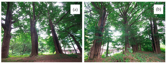
Figure 3.
Ginko biloba L. in the Shennong Temple area. (a) From left to right, tree no. 1 to 4; (b) From left to right, tree no. 5 to 8. Source: Negishi, T.
These trees exhibit various forms of damage, such as scorching, hollows, and tilting. All of them are estimated to be over 100 years old and have been confirmed to have existed before the disasters occurred (Figure 4).
2.2. Survey Period and Personnel
The tree internal diagnosis was conducted by one operator and one assistant (responsible for equipment transportation and setup) during the period from 20 May to 31 July 2022. Data analysis and literature research were subsequently carried out from 1 August 2022, to 10 July 2023.
2.3. Equipment Used
The non-destructive decay diagnosis was conducted using a sonic tomography tree internal diagnostic device (product name: Dr. Woods, JFE Civil Engineering & Construction Corp.) Appendix A. This device utilizes oscillation-reception sensors placed on the surface of the measured object to generate and receive longitudinal waves between the sensors. Based on the principle that sound waves traveling through hard materials propagate faster than through softer ones such as decayed wood, the measured values of the propagation velocities can be used to estimate and visualize the internal tree structure. During the installation of the sensors, the tips of the connected needles penetrate the bark and only penetrate the tree’s interior by approximately 2 to 3 mm. This is believed to impose minimal stress on the tree’s growth.
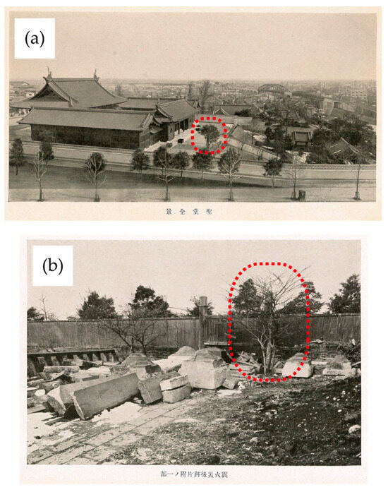
Figure 4.
(a) A panoramic view of the Yusima Seido Temple 12 years after the Great Kanto earthquake, seen from the west side. Tree no. 12 (red dash framed), Castanopsis sieboldii (Makino) Hatus. ex T. Yamaz. et Mashiba subsp. Sieboldii, can be seen. Photograph title: [A panoramic view of Yusima seido Temple] Seido zennkei (in Japanese) [39]. (b) Tree no. 13 (red dash framed), Torreya nucifera (L.) Siebold et Zucc., after the earthquake, viewed from the east side towards the west gate. Photograph title: [Part of cleaning up after the earthquake] Shinsai-go atokataduke no ichibu (in Japanese) [40].
2.4. Measurement Method
In order to standardize the measurement data for the disaster-affected trees, the measurement method used by Negishi et al. [27] was followed, as outlined below.
2.4.1. Measurement of Tree Height
The height of the target tree was measured using the Vertex IV (Haglof Sweden AB) instrument.
2.4.2. Heights for Sonic Sensor Measurements
As a general rule, for each tree, measurements were taken at three cross-sections located 0.3 m, 0.9 m, and 1.5 m above ground level (G.L.). The lowest measurement height was set at 0.3 m, the highest at 1.5 m, and the middle at 0.9 m, accommodating the placement of the sensors. Measurements at heights above 1.5 m would require installation of equipment such as scaffolding to enable device placement. Considering the prioritization of assessing the decay conditions at the base and the intention to conduct measurements on numerous disaster-damaged trees for data collection in the future, the measurement range was set from 0.3 m to 1.5 m.
However, for tree no. 2, due to a bifurcation near 1.2 m above G.L., the main trunk with damage such as scorching was labeled as “2-150-1”, and the other trunk was labeled as “2-150-2”. Tree no. 4 bifurcated close to 0.6 m above G.L. Therefore, measurements were taken of four sections: the main trunk with fire damage on the western side, labeled as “4-90-1” and “4-150-1”, and the split eastern side labeled as “4-90-2” and “4-150-2”. For tree no. 7, since the tree was situated on a steep slope, it was challenging to set up the equipment. Due to safety concerns, measurements were taken only at the cross-sections of 0.3 m and 0.9 m above G.L., which were feasible without additional equipment. Consequently, a total of 41 cross-sections from the 13 target trees were measured.
2.4.3. Time Required for Measurements
It took approximately 60 min to measure one cross-section, from the start of the coordinate measurement prior to sensor placement to the completion of the sonic measurement, thus requiring approximately 180 min to complete all the measurements for each individual tree.
2.4.4. Measurement Procedure
Sixteen sensors were evenly placed on the surface of the tree trunk and connected to the diagnostic device. The coordinates of each sensor were written down, and sensor checks were performed. If there were no issues with the sensor setup, a frequency of 30 kHz and a repetition of 4 cycles were set, and the measurement was initiated. Transmission started from sensor channel 1, and reception occurred at channels 2 to 16. The captured sound waves were automatically recorded in the diagnostic program on a PC. The oscillation was then repeated sequentially from sensor channel 2 to 16. The time of arrival of the received sound waves was recorded, and based on the distances between the sensors, the speed of sound between each sensor pair was calculated. The speed of sound for each mesh was displayed using geostatistical methods (Kriging). The diagnostic program’s image processing software automatically generated visualizations such as “sound speed distribution” and “analytical cross-section”. The noise deviation was set at “3”, and the detection level was set at “5”.
As discussed earlier, it has been suggested that irregularly shaped hollows may result in differences between the actual conditions and the sonic data assessments. Considering this, each tree trunk within the measurement range was diagnosed. Recognizing that there is a possibility of overestimating rather than underestimating decay and/or hollows, the decision was made to set the range for determining “decay and/or hollow” within the displayed propagation speed of 250 to 1500 m/s in the diagnostic device, specifically within the range of 250 to 300 m/s.
3. Results
3.1. Decay and/or Hollow Rate
Table 1 displays the measurement values for all the tree sections. Figure 5, Figure 6, Figure 7 and Figure 8 show examples of the “Analysis Cross-Sections” for trees 3, 7, 9, and 12, calculated using the diagnostic device. These cross-sections provide a visualization of the results of the frequency oscillations performed by each sensor, with the vertical and horizontal axes representing the dimensions of the wood (in mm). The color bar on the right or top indicates sound wave velocities ranging from 250 to 1500 m/s, with red representing 250 m/s and deep blue representing 1500 m/s. The decay and/or hollow rate was calculated based on the ratio of the area of decay and/or hollow regions (250–300 m/s) determined using the diagnostic device to the total cross-sectional area.

Table 1.
List of cross-section measurements. Source: Negishi, T.
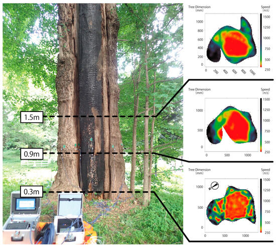
Figure 5.
The measurement status and analysis cross-section diagram for tree no. 3. Source: Negishi, T.
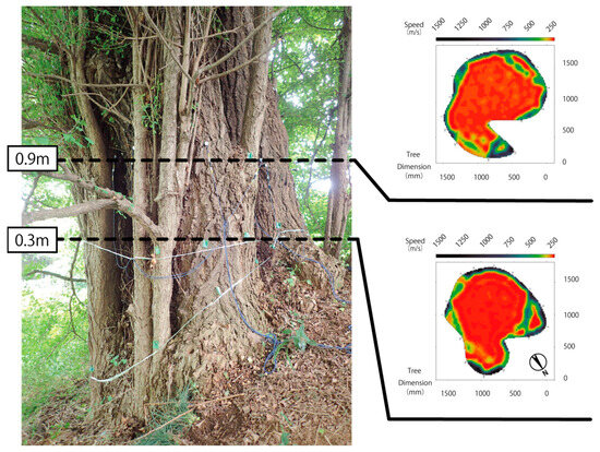
Figure 6.
Measurement status and analysis cross-section diagram for tree no. 7, which is located on a steep slope. Source: Negishi, T.
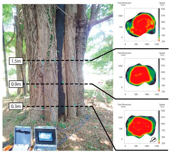
Figure 7.
TMeasurement status and analysis cross-section diagram for tree no. 9. Source: Negishi, T.
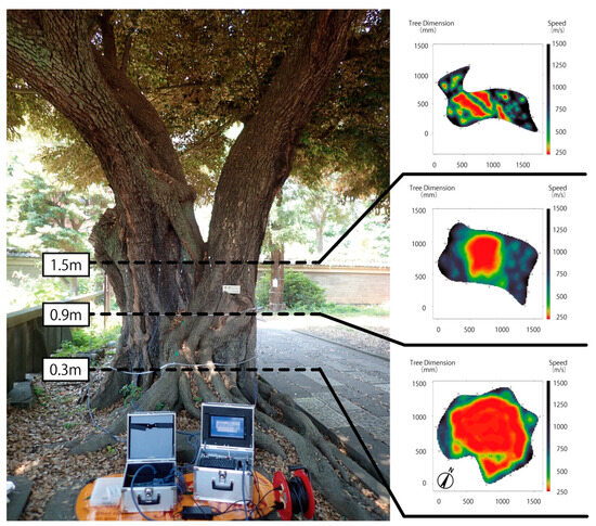
Figure 8.
Measurement status and analysis cross-section diagram for tree no. 12. Source: Negishi, T.
Out of the 41 cross-sections, decay and/or hollow percentages were calculated for 29 cross-sections. Cross-section nos. 1-30, 2-90, 3-30 to 150, 5-30, 6-30 to 150, 7-30, 90, 8-90, 150, 9-30 to 150, 10-30, and 12-30 showed decay and/or hollow percentages of over 30%. Among these, two cross-sections, nos. 7-30 and 7-90, had decay and/or hollow percentages of over 60%. As an example of assessing tree hazard, if there is circular heartwood decay in the central part of the trunk without an opening and the diameter of the decay and/or hollow is 77% (decay and/or hollow percentage based on cross-sectional area is 59%) or more of the stem wood diameter, it falls into the “danger zone”. If it is 58% or more (decay and/or hollow percentage based on cross-sectional area is 34%), it falls into the “warning zone”.
The trees with 30% or more decay and/or hollows detected, except for cross-section nos. 10-30, were large-diameter trees with an average diameter of 1.0 m or more.
Tree No. 1 has a burnt or damaged trunk exposed in the upper part of the tree, which is at a measuring height of 1.5 m or more. The decay/hollow rate was calculated to be 42.4% at the 0.3 m measuring height, 25.6% at 0.9 m, and 12.0% at 1.5 m. From this, it is considered that there is a continuous decay and/or hollow section from the base to a height of at least 1.5 m.
Tree no. 2 has a cavity with charred remains inside it. Although there is no decay at the base, decay was observed in sections 2-90 and 2-150. Sections 2-30 to 2-150-1 show the main trunk with damage. Section 2-150-2 is a branch that splits into two at a height of 1.5 m, and it has no visible damage or decay/hollowing.
Tree no. 3 (Figure 5) has a burnt trunk from the base to the top; a typical characteristic of earthquake- and war-damaged trees. The damaged trunk shows signs of decay, but it is supported by a healthy outer bark that has grown around it, providing support to the entire tree.
For tree no. 4, the decay and/or hollow rate was only 6.7% at the measurement height of 0.3 m. This value is not particularly high, and no decayed areas were visible from the outside. Tree no. 4 has grown healthy outer bark surrounding the burnt trunk. While there are slight decay cavities at the base, they do not seem to significantly affect the tree’s growth. No internal decay was observed in sections 4-90-2 or 4-150-2, which are on the damaged side of the trunk, and there were no signs of decay on the outer side of the trunk that enveloped it.
Tree nos. 5, 6, 7, 8, and 9 exhibit the same general tree shape (cross-section type) and trunk damage pattern as Tree no. 3, and all of their cross-sections show signs of decay cavities (Figure 6 and Figure 7).
Tree no. 7, which had a decay and/or hollow rate of over 60%, is a large-diameter tree with an average diameter of over 1.5 m. It is speculated that the entire north side of the tree, from the base to the top of the trunk, is charred. The outside bark of the tree has continued to grow in a way that complements the decay and/or hollow in the trunk (Figure 6). This tree is located on a slope of approximately 25%. This is an unstable location for a tree, but it has firmly anchored its roots in the soil. These roots are supporting the trunk, which does not show any obvious adverse effects regarding its vitality. This study is the first known occurrence of sonic measurements of a tree on sloped terrain. Both the cross-section parallel to the theoretical horizontal ground and the cross-section parallel to the slope were measured for section 7-30. When measuring parallel to the slope, data collection was possible but yielded unstable results. Measuring parallel to the theoretical horizontal ground, as in flat terrain, was successful. In the future, if measurements on sloped terrain are needed, this study’s results will be used as a reference for determining the optimum measurement approach.
Tree no. 10 showed a decay and/or hollow rate of 37.6% at the 0.3 m measuring height and 15.6% at the 1.5 m measuring height. Although the decay rate at the 0.9 m measuring height was 0.0%, this does not necessarily mean that there is no decay and/or hollow at all at this height. Given the decay above and below this height, it is possible that there is continuous decay and/or hollow formation from the base to a height of at least 1.5 m. However, no distinctive damage characteristics of earthquake- and war-damaged trees, such as scorching or cavities, were observed at any of the measuring heights, and no fungal fruiting bodies were found at the base.
Tree no. 12 showed a decay and/or hollow rate of 55.1% at the 0.3 m measuring height, 18.2% at 0.9 m, and 14.6% at 1.5 m. There was continuous decay or cavity formation from the base to a height of 1.5 m, which requires regular monitoring. At each measuring height, there were distinctive damage characteristics of earthquake and war-damaged trees, such as scorching or hollows, but again, no fungal fruiting bodies were confirmed (Figure 8).
Only two trees, no. 11, and no. 13, did not show signs of decay and/or hollows. These trees both had a circumference at the measuring heights of less than 1.0 m. Tree no. 11 showed a slight tilt in its trunk, but no damage was observed within the measurement range. Hollows and slits were observed on the upper part of the trunk of tree no. 13 above the measurement height, but within the measurement range, the trunk had already healed and enveloped the damage.
3.2. Types of Cross-Sections
The focus of this study is not on the entire tree but specifically on the characteristics of the damage to the trunk cross-sections. The cross-sections at each measurement height were classified into five types based on previous studies [27]. When applying this classification method in this study, a new category, “Mixed Type”, was identified. The most common type in this study was Type II, followed by Type V (Figure 9).
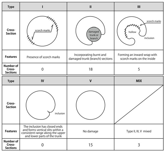
Figure 9.
The types of diagnosed cross-sections and their respective quantities. Source: Negishi, T.
Type I encompasses burn damage that covers the entire surface of the bark, which was not observed in this study. Type II involves the bark partially encasing burn-damaged wood sections of the trunk or branches, with openings sealed by the damaged trunk or branch. This type was applicable to section nos. 3-30, 3-90, 3-150, 4-30, 5-30, 5-90, 5-150, 6-30, 6-90, 6-150, 7-30, 7-90, 8-30, 8-90, 8-150, 9-30, 9-90, and 9-150 in our study. Type III includes an open hollow with sufficient space for sensor placement (approximately 2 × 10 cm) and has burn damage on the hollow’s side walls. These hollows form a ‘C’ shape, and this type was observed in section nos. 2-30, 2-90-1, 2-150-1, 4-90-1, and 4-150-1. During the measurements, these openings were not considered part of the cavity; instead, we focused solely on the internal decay and/or hollow within the tree. Type IV refers to cases where the encasement of the burned damaged area has been completed, and only vertical slit-like openings are visible. This type was not observed in our study. All other cases, where no damage characteristics of war-damaged trees were observed in the measurement range, from the base to 1.5 m in height, were classified as Type V. While there was no apparent damage to the exterior of the cross-sections within the measurement range of these trees, damage marks were found above the 1.5 m measurement height in the case of tree nos. 1 and 13. This type was applicable to sections 1-30, 1-90, 1-150, 2-150-2, 4-90-2, 4-150-2, 10-30, 10-90, 10-150, 11-30, 11-90, 11-150, 13-30, 13-90, and 13-150.
Sections 12-30, 12-90, and 12-150 on tree no. 12 were classified as mixed types. Tree no. 12 had a circumference of nearly 5.0 m and a diameter of approximately 1.5 m in terms of cross-sectional area, making it a large-diameter tree. When examining photos from shortly after the Great Kanto earthquake (Figure 4a), it becomes apparent that the most significant damage occurred on the western-facing trunk of tree no. 12, based on the position of the completely burned Taisei-den Hall at that time relative to the tree. In contrast, the eastern-facing trunk appears to have grown thicker after the earthquake. Currently, the eastern and western trunks have fused from the base to form a co-dominant trunk. Between the G.L. and the 1.5 m measurement height on the western trunk, there is a condition where it has incorporated a hollowed and scorched damaged trunk, while the eastern side does not show any damage. Therefore, it can be classified as a compound type of cross-section involving Types II, III, and V. These findings suggest that as trees grow larger in diameter, co-dominance of the trees’ trunks and branches progress, leading to more complex trunk shapes.
In addition, for Type II cross-sections, two different measurement approaches were explored concerning sensor placement: one involving positioning the sensors within the withered parts and the other avoiding these withered areas. However, no significant differences were observed in the data obtained using these two methods. Two measurement techniques were also employed for Type III: one with sensors placed inside the hollow voids and the other with sensors installed at both ends of the open cavities, with measurements corrected using the measurement software for the “open cavity setup”. Nevertheless, again, there were no notable differences between the results of these two approaches.
4. Discussion and Conclusions
4.1. Internal Diagnosis of Trees Holding Urban Memories
At present, owners of earthquake-damaged and war-damaged trees without specialized tree knowledge often face difficulties, including financial constraints, in obtaining accurate and up-to-date information about the internal condition of their trees, such as from sonic tomography tree internal diagnosis devices. Furthermore, the number of trees that can be targeted is often limited, and since the growth conditions and origins of damage and decay vary from tree to tree, it is challenging to systematically compile measurement results. Additionally, information from individual tree assessments is rarely made public. There is a lack of databases or records of diagnostic results maintained by tree diagnostic professionals. In this context, the effort to obtain diagnostic results for multiple trees of advanced age and similar damage or decay origins is of significant importance for the conservation of Japan’s urban green spaces and environments.
The internal conditions of trees damaged by the Great Kanto earthquake in 1923 and the Tokyo Air Raid in 1945 were measured using a sonic tomography tree internal diagnosis device, with three cross-sections measured for each tree. The results showed that it is possible not only to diagnose damage traces based on information that can be confirmed from the exterior but also to understand the detailed state of decay and/or hollow inside the tree from a three-dimensional perspective. By visualizing the information inside a tree that is normally not visible, it should be possible to increase the interest and curiosity of tree owners regarding earthquake-damaged and war-damaged trees. Furthermore, this would make it easier to emphasize the need for appropriate conservation management of trees with historical value. However, there are some limitations to this method. Due to the inability to fell the trees to confirm the diagnostic findings, diagnosticians should always be aware that the obtained measurements of hollowness and decay may not be perfectly accurate. Furthermore, when conveying the obtained results to war-damaged tree owners or individuals without specialized knowledge, it is important to explain this limitation clearly.
In the future, as further tree internal diagnoses are conducted on war-damaged trees that still exist throughout Japan, it is expected that more trees can be identified that have been damaged by multiple disasters, like the trees in this study. The earthquake-damaged trees studied in this survey were primarily damaged by fires resulting from the Great Kanto earthquake. However, it is also conceivable that there are earthquake-damaged trees affected by other factors such as tsunamis or landslides. Therefore, the diagnosis of trees damaged by different types of disasters is a future task to consider.
4.2. Challenges Identified through Measurements
The measurements of cross-sections of trees growing on sloped terrain indicate that it is better to measure the cross-sections perpendicular to the tree trunk rather than parallel to the ground, as is done for trees on flat terrain. This finding will be applied in future investigations.
The cross-section results also showed that some cross-sections do not fit clearly into any of the previously classified Types I to V, and instead exhibit a mixture of characteristics from different cross-section types. This finding could become more common in the future as the number of diagnoses increases, meaning that various mixed types may emerge. Type V often does not show any damage within the measured range, but damage is frequently observed in the upper part of the tree beyond the measurement range. Therefore, it may be advisable in the future to include a measurement of the upper part of the tree. Furthermore, although this study obtained some data for Chinquapin (Castanopsis sieboldii (Makino) Hatus. ex T.Yamaz. et Mashiba subsp. Sieboldii) and Japanese nutmeg (Torreya nucifera (L.) Siebold et Zucc.) trees, the data were obtained from only one tree of each type. Therefore, in future studies, we aim to increase the number of diagnoses for each tree species.
The predominance of Type II, with openings sealed by the damaged trunk or branch, over Type III, where the portion exposed to intense heat becomes hollow, suggests that factors such as the area of the trunk exposed to strong heat and the duration of exposure may have influenced the outcomes. To understand this further, it will be essential to thoroughly examine the available records regarding meteorological conditions such as wind speed and weather at the time of the disasters. Additionally, conducting comparisons with other areas where disaster-affected trees are concentrated will be necessary. These tasks will be part of our future research agenda.
4.3. Toward Tree Memory Conservation
The extent of the damage caused by fires resulting from earthquakes, the impact of incendiary bombs during air raids, and the broader circumstances during these events cannot be fully understood through the examination of individual trees alone. However, it is believed that a collective assessment of surviving trees could help to shed light on these aspects. Therefore, the initial step was to investigate whether it was feasible to measure the cross-sections of the 13 earthquake- and war-damaged trees on the same premises using a tree internal decay diagnostic device. By comparing the results of this study with eyewitness accounts, we plan to ascertain the potential of these earthquake and war-damaged trees to serve as storytellers of those events.
Despite the presence of numerous war-damaged and disaster-affected trees throughout Japan, they have not received much attention in the past. Furthermore, it is probable that similar instances of trees holding unique urban historical narratives can be found in other countries and regions around the world. While the availability of tree diagnosis equipment may vary by country and region, we aim to enhance awareness of the existence of such trees by promptly sharing the information from our research and studies. This, in turn, can contribute to the appropriate preservation of urban green environments for future generations, support disaster preparedness, and promote peace education.
Author Contributions
Conceptualization, T.N. and H.K.; methodology, T.N.; software, T.N.; validation, T.N. and H.K.; formal analysis, T.N.; investigation, T.N.; resources, T.N.; data curation, T.N.; writing—original draft preparation, T.N.; writing—review and editing, T.N. and H.K.; visualization, T.N.; supervision, H.K.; project administration, T.N. and H.K.; funding acquisition, T.N. All authors have read and agreed to the published version of the manuscript.
Funding
This research was funded by JSPS KAKENHI, grant number JP22K14913.
Data Availability Statement
Some or all data of the that support the findings of this study are available from the corresponding author upon reasonable request.
Acknowledgments
We gratefully acknowledge the support of Shimizu from the Yushima-Seido Temple.
Conflicts of Interest
The authors declare no conflict of interest.
Appendix A
In the process of selecting the diagnosis equipment, as part of the preliminary investigation, we conducted tests on two trees with diameters of approximately 2.0 m, which exhibited the three major characteristics of charring, cavities, and leaning. We used two types of equipment: the Dr. Woods equipment used in this study and another type of sonic tomography tree internal diagnosis device. The latter involved operators striking sensors at evenly spaced distances on the tree trunk’s surface to measure decay based on the sound waves generated. However, we were unable to obtain measurable values using the latter device. On the other hand, the Dr. Woods device we used in the main study generated sound waves with a constant frequency from a machine, which was capable of providing measurement data with a consistent quality. Both devices were operated normally under identical conditions, including the survey environment, date, and time, and the operators were equally experienced with both devices. Ideally, conducting a comparative assessment using all candidate equipment would have been desirable, but due to limitations in terms of both finances and time, we opted to use the diagnostic equipment, which has a proven track record of reliably measuring “large-diameter trees with damage”; a common characteristic of war-damaged trees.
References
- Hinokidani, M.; Sumita, S. A Study on the Changing Process of Housing Tenure: Part 1 The changing process of the owner-occupation in Japanese 24 cities during the pre- and post- World War Second Periods. Plan. Environ. Eng. (Trans. AIJ) 1988, 392, 136–146. [Google Scholar]
- Pazos, P.R.I. The Historical Development of the Tokyo Skyline: Timeline and Morphology. Archit. Urban Plan. Des. 2014, 13, 609–615. [Google Scholar]
- Kobiałka, D.; Frąckowiak, M.; Kajda, K. Tree memories of the Second World War: A case study of common beeches from Chycina, Poland. Antiquity 2015, 89, 683–696. [Google Scholar] [CrossRef][Green Version]
- Bizkaiko Batzar Nagusiak-Juntas Generales de Bizkaia. Available online: https://jjggbizkaia.eus/en/seats/the-tree-of-gernika (accessed on 22 September 2023).
- Mariendom Hildesheim. Available online: https://www.dom-hildesheim.de/en/content/1000-years-age-rosetree (accessed on 22 September 2023).
- Baumkunde.de. Baumkunde Forum. Available online: https://www.baumkunde.de/forum/viewtopic.php?t=22174 (accessed on 22 September 2023).
- Friedhöfe in Potsdam. Available online: https://www.friedhof-in-potsdam.de/# (accessed on 22 September 2023).
- Cheng, S.; McBride, J.R. Restoration of the urban forests of Tokyo and Hiroshima following World War II. Urban For. Urban Green. 2006, 5, 155–168. [Google Scholar] [CrossRef]
- Stilgenbauer, J.; McBride, J.R. Reconstruction of urban forests in Hamburg and Dresden after World War II. Landsc. J. 2010, 29, 144–160. [Google Scholar] [CrossRef]
- Lacan, I.; McBride, J.R. War and trees: The destruction and replanting of the urban and peri-urban forest of Sarajevo, Bosnia and Herzegovina. Urban For. Urban Green. 2009, 8, 133–148. [Google Scholar] [CrossRef]
- Lacan, I.; McBride, J.R.; Duane, D.W. Urban forest condition and succession in the abandoned city of Pripyat, near Chernobyl, Ukraine. Urban For. Urban Green. 2015, 14, 1068–1078. [Google Scholar] [CrossRef]
- Claudia, H.; St George, S.; Konter, O.; Harr, L.; Scholz, D.; Kirchhefer, A.; Esper, J. Warfare dendrochronology: Trees witness the deployment of the German battleship Tirpitz in Norway. Anthropocene 2019, 27, 100212. [Google Scholar]
- Avenues of Honour Project. Available online: https://avenuesofhonour.org (accessed on 28 September 2023).
- Collins, G. World Wars & Landscape Architecture. Landsc. Archit. Aust. 2014, 144, 20–23. [Google Scholar]
- Takemura, M. Tracing the Great Kanto Earthquake: Memories of disasters in modern times. In Kanto-Daishinsai Wo Aruku: Gendai Ni Ikiru Saigai No Kioku; Yoshikawa Koubunkan: Tokyo, Japan, 2012. (In Japanese) [Google Scholar]
- Earthquake Prevention Investigation Committee. Shinsai Yobou Chousa-kai. In Earthquake Prevention Investigation Committee Report No.100 Great Kanto Earthquake Survey Report; Shinsai Yobou Chousa-kai houkoku No. 100 Kanto Daijishin Chousa-houbun; Cabinet Office, Government of Japan: Tokyo, Japan, 1925. (In Japanese) [Google Scholar]
- United Nations Information Centre, Tokyo. Message to Hiroshima Peace Memorial on the 78th Anniversary of the Atomic Bombing of Hiroshima. Available online: https://www.unic.or.jp/news_press/messages_speeches/sg/48511/?lang=en (accessed on 2 September 2023).
- United Nations Information Centre Tokyo. Message to Nagasaki Peace Memorial on the 78th Anniversary of the Atomic Bombing of Nagasaki. Available online: https://www.unic.or.jp/news_press/messages_speeches/sg/48540/?lang=en (accessed on 2 September 2023).
- Owaki, N.; Suzuki, M.; Horiguchi, C. Abnormal Tree Form of A-bombed Trees in Hiroshima in the Spatial Relationship with the Ground Zero. J. Jpn. Inst. Landsc. Archit. 2014, 77, 627–632. [Google Scholar] [CrossRef][Green Version]
- Owaki, N.; Suzuki, M.; Ohbi, K. Searching Process and Issues on conservation of Undiscovered A-bombed Trees in Nagasaki. J. Jpn. Inst. Landsc. Archit. 2016, 79, 541–544. [Google Scholar] [CrossRef]
- Saotome, K. The collection of Tokyo air raids photographs: Records of damage caused by indiscriminate bombing by the US military. In Tokyo-Kusyu Syashin-Syu: America-Gun No Musabetu-Bakugeki Ni Yoru Higai-Kiroku; Bensei-Syuppan: Tokyo, Japan, 2015. (In Japanese) [Google Scholar]
- Kanno, H.; Negishi, T. A Study on Present Distribution Characteristics of War-damaged Trees in 23 Wards in Tokyo. J. Jpn. Inst. Landsc. Archit. 2020, 83, 575–578. [Google Scholar] [CrossRef]
- Negishi, T.; Kanno, H. Present Distribution and Condition of War-damaged Trees in Three East Tokyo Wards. J. Jpn. Inst. Landsc. Archit. 2015, 78, 687–692. [Google Scholar] [CrossRef][Green Version]
- Kanno, H.; Negishi, T. Distribution and Present Condition of War-damaged Trees in Three East Tokyo Wards. J. Jpn. Inst. Landsc. Archit. 2016, 79, 471–476. [Google Scholar] [CrossRef][Green Version]
- Mattheck, C.; Breloer, H. Field guide for Visual Tree Assessment (VTA). Arboric. J. 1994, 18, 1–23. [Google Scholar] [CrossRef]
- Hori, T. Diagnosis Method of Tree Health: Jyumoku Shindan Cyousa-Hou; Kodansha: Tokyo, Japan, 2014. (In Japanese) [Google Scholar]
- Negishi, T.; Kanno, H. Nondestructive decay diagnosis of war-damaged trees by sonic tomography. J. Jpn. Inst. Landsc. Archit. 2022, 85, 433–438. [Google Scholar] [CrossRef]
- Maeda, Y.; Nakamura, N.; Koyama, K.; Yabe, H.; Tsuchiya, R. Stem damage assessment of Japanese cedar after forest fire—What to do with fire damaged trees. Tree For. Health 2013, 17, 102–112. [Google Scholar]
- Hasegawa, K.; Sassa, T. Some changes of stem wood qualities in the Japanese ceders (Cryptomeria japonica D. Don) damaged by forest floor fire. Jpn. J. For. Environ. 1993, 35, 1–9. [Google Scholar]
- Lafon, C.; Naito, A.; Grissino-Mayer, H.; Horn, S.P.; Waldrop, T. Fire History of the Appalachian Region: A Review and Synthesis. Gen. Tech. Rep. SRS 2017, 219, 23–29. [Google Scholar]
- Gutsell, S.L.; Johnson, E.A. How fire scars are formed: Coupling a disturbance process to its ecological effect. Can. J. For. Res. 1996, 26, 166–174. [Google Scholar] [CrossRef]
- Tokue, I.; Yonezawa, H.; Abe, T.; Ikeda, T.; Onodera, Y.; Goto, N.; Takashima, T.; Nakada, R.; Hagiri, T.; Hasegawa, Y.; et al. Tree diagnosis with Dr. Woods and observation of stem cross sections after felling—Cherry trees in Seya dai2 Park, Yokohama City. Tree For. Health 2015, 19, 46–47. [Google Scholar]
- Hashitani, H.; Maeshima, A.; Yamamoto, S.; Ota, Y.; Hattori, T.; Yamashita, K.; Ido, H.; Yamada, T.; Nishioka, Y.; Yanagisawa, K.; et al. Physical properties of Japanese larch decayed by Porodaedalea chrysoloma. Tree For. Health 2019, 23, 96–97. [Google Scholar]
- Nikaido, Y.; Higuchi, H.; Akimoto, S.; Hosono, T. Comparison of four decay diagnostic instruments on artificial cavities in woods of Japanese zelkova (Zelkova serrata). Tree For. Health 2020, 24, 195–203. [Google Scholar]
- Yamashita, K.; Ota, Y.; Yonezawa, H.; Tokue, I.; Yamada, T. Detection of artificial cavities by Dr. Woods. Tree For. Health 2016, 20, 143–144. [Google Scholar]
- Tokyo Municipal Office. The Reconstruction of Tokyo; Kawaguchi Printing Works: Tokyo, Japan, 1933. [Google Scholar]
- Historic site Yushima Seido Temple. Shiseki Yushima Seido. Available online: http://www.seido.or.jp/index.html (accessed on 22 September 2023).
- Tokyo-kusyu wo kirokusuru-kai. Great Tokyo Air Raid-War Damage Documentation. In Tokyo Daikushu–Sensaishi; Kodansha: Tokyo, Japan, 1975; Volume 1, pp. 944–946. (In Japanese) [Google Scholar]
- Fukushima, K. Yushima cathedoral restoration memorial: Confucian convention magazine. In Yushima Seido Fukkou Kinen: Jyudou Taikai-Shi; Shibun-kai: Tokyo, Japan, 1936. (In Japanese) [Google Scholar]
- Seido fukkou kisei-kai. Yushima Cathedoral Restoration Strategy. In Seido Fukkou Ryaku-Shi; Seido fukkou kisei-kai: Tokyo, Japan, 1935. (In Japanese) [Google Scholar]
Disclaimer/Publisher’s Note: The statements, opinions and data contained in all publications are solely those of the individual author(s) and contributor(s) and not of MDPI and/or the editor(s). MDPI and/or the editor(s) disclaim responsibility for any injury to people or property resulting from any ideas, methods, instructions or products referred to in the content. |
© 2023 by the authors. Licensee MDPI, Basel, Switzerland. This article is an open access article distributed under the terms and conditions of the Creative Commons Attribution (CC BY) license (https://creativecommons.org/licenses/by/4.0/).