Article

An Advanced Open Land Use Database as a Resource to Address Destination Earth Challenges

1
Department of Geomatics, University of West Bohemia in Pilsen, Univerzitní 8, 301 00 Pilsen, Czech Republic
2
Plan4All z.s., K Rybníčku 557, 330 12 Horní Bříza, Czech Republic
3
Laboratory on Geoinformatics and Cartography, Department of Geography, Faculty of Science, Masaryk University, Kotlarska 2, 611 37 Brno, Czech Republic
4
WIRELESSINFO, Cholinská 19, 784 01 Litovel, Czech Republic
*
Author to whom correspondence should be addressed.
Land 2022, 11(9), 1552; https://doi.org/10.3390/land11091552
Submission received: 2 August 2022 / Revised: 31 August 2022 / Accepted: 8 September 2022 / Published: 13 September 2022

Abstract

:
Land-use and land-cover (LULC) themes are important for many domains, especially when they process environmental and socio-economic phenomena. The evolution of a land-use database called Open Land Use (OLU) started in 2013 and was continued by adapting many user requirements. The goal of this study was to design a new version of the OLU database that would better fit the gathered user requirements collected by projects using LULC data. A formal definition of the developed data model through Unified Modeling Language (UML) class diagrams, a feature catalogue based on ISO 19110 and SQL scripts for setting up the OLU database, are the key achievements of the presented paper. The presented research provides a multi-scale open database of LULC information supporting the DestinE initiative to develop a very-high-precision digital model of the earth. The novel spatio-temporal thematic approach also lies in modular views of the OLU database.

1. Introduction

Geospatial data on land use and land cover (LULC) contain information about the biophysical cover of the earth’s surface and the way land is exploited by humans [1]. LULC data play a vital role in various specialisms concerning both environmental and socio-economic phenomena. This includes modeling human population, urban growth, urban transformation, transport, and landscape development. LULC have an impact on surface run-off, water quality and availability, soil and air moisture, climate change, and biodiversity. Monitoring how LULC change over time provides invaluable information for planning purposes in both urban and rural areas.
The terms “land cover” (LC) and “land use” (LU) can be relatively clearly distinguished. In practice, however, the terms are often used interchangeably, as stated by [2]. LC is “the observed physical and biological cover of the earth’s land, like vegetation or man-made features.” In contrast, LU is “the total of arrangements, activities, and inputs that people undertake in a certain land cover type” [3,4]. Both LU and LC are emphasized in countless legally binding documents, scientific papers, strategies, best practices, models, and applications. For instance, in Europe, the Infrastructure for Spatial Information in the European Community (INSPIRE) [5] has land use and land cover as two out of 34 spatial-data themes.
Modeling LULC and using predictive capacities help us to monitor the health of the earth and to better integrate economic and social needs with the environment. This topic became a central point of political discourse on sustainability. For instance, the EU started a discussion on developing Destination Earth (DestinE) in support of the European Digital Strategy, the European Green Deal, and the establishment of the Green Deal Data Space, one of the data spaces envisaged by the European Strategy for Data [6]. DestinE should become a dynamic, interactive, computing, and data-intensive digital twin of the Earth. As such, DestinE is a multi-dimensional replica of a living or non-living physical entity that enables different user groups to interact with vast amounts of natural and socio-economic information [7]. In addition to a cloud-based modeling, simulation, and predictive-analytics platform and digital twins of various aspects of the earth system, data including LULC data are considered one of the core elements of DestinE [8]. An important role of LU data was demonstrated by [9], who analyzed 30 use cases relevant to DestinE. The use cases included climate-change adaptation, climate modeling, ecosystem services, biodiversity, natural hazards, and renewable energy.

1.1. Goals of the Paper

The authors present in this paper the evolution of an advanced land-use database that is intended as a core dataset of DestinE. The work on the land-use database design started in 2013 during the Plan4business project and the INSPIRE Land Use Data Specifications, including the Hierarchical INSPIRE Land Use Classification System (HILUCS) serving as a starting point. A fully INSPIRE-compliant and seamless flat-table schema database called the Open Land Use (OLU) dataset, comprising data from the Coordination of Information on the Environment (CORINE) Land Cover (CLC) and Urban Atlas (UA) enriched by multiple regional open data sources, was created and made publicly available [10].
Based on user requirements collected by the Plan4business and seven follow-up European projects using LULC data, the initial OLU dataset was extended by integrating additional datasets including land-cover data. As a result, an OLU database enriched by other data including soil properties, exposition, slope, land cover, and climatic data has been designed. The OLU database follows an iterative development process.
This paper analyzes and presents requirements and use cases of the OLU dataset based on user feedback collected since 2013. The main goal of this study was to design a new version of the LULC database that would better fit the needs of various research projects and their requirements, use cases, and applications.
The goals of this paper were defined as follows:
  • The OLU model/database should capture data and attributes at various levels of detail (multi-level geometries and attributes).
  • The OLU model/database should store data from different periods (multi-temporal data) and support spatio-temporal slicing like the hypercube approach in remote sensing.
  • The OLU model/database should derive data from multiple sources for areas and levels of detail where data are incomplete (too coarse or missing).
Theoretical goals are mainly focused on the design of a data model based on specific requirements provided by practical use cases. It was necessary to design a data model integrating and harmonizing different data sources with variable scales and heterogeneous attributes or original vectors as well as a raster format.
The practical goals are focused on implementation of the designed data model and importing of general and thematic datasets. The main practical goal is to test the designed mechanism of spatio-temporal views to provide data exports for specific needs.

1.2. Related Works

LULC data are strategic for diverse analyses on sustainability planning. This creates demands to harmonize LULC data to compare them between countries and to compile time series to analyze change dynamics and detect trends [2,11,12]. The first digital classification—the United States Geological Survey (USGS) LU/LC Classification System, developed as a hierarchical subdivision of the classes—was widely used to produce LC maps primarily from satellite images [13,14]. After that, the US Earth Satellite Corporation (EarthSat) GeoCover Land Cover Legend defined 13 classes based on the USGS 1976 classification system [15]. The National Land Cover Data (NLCD) Classification System was defined by the National Land Cover Characterization Project as a univocal classification method for the USA [16,17]. An example of newer LULC data available for the USA is GAP/LANDFIRE National Terrestrial Ecosystems 2011 [18].
In 1993, the United Nations Environmental Programme/Food and Agriculture Organization of the United Nations (UNEP/FAO), USGS, and International Geosphere-Biosphere Programme-Data, and later, in 1996, the Information System (IGBP-DIS) Land Cover Legend, were derived from the modification of the 1976 USGS classification method/system [19]. The Land Cover Classification System (LCCS) is a system based on universal valid land-cover criteria developed by FAO/UNEP [20]. In the LCCS, the Global Land Cover Network (GLCN) was developed [21]. Global LULC data sets such as Global Land Cover SHARE (GLC-SHARE) provided also by the FAO are characterized by relatively lower spatial resolution, i.e., 1 km per pixel [22]. National categories of LULC differ, but many have been harmonized under the influence of FAO’s periodical World Census of Agriculture [4,23,24].
The European Commission (EC) presents the CORINE Land Cover (CLC) program and its later updates as basic instruments for the definition of political programs related to the location and environment at the (pan-)European level [25,26]. The methodology of CLC mapping was extended for the mapping of European megacities. The first steps in this direction were completed as part of the Murbandy/Moland project, which was extended later to Urban Atlas 1 (UA) [27].
Verification of the LU dataset derived from remote-sensing products complemented by fieldworks has been realized since 2006 by Eurostat within the LUCAS (Land Use and Cover Area Frame Survey) project [28]. In 2006, 2012, and 2018, the Urban Atlas datasets were created as more detailed and comparable LULC data for built-up areas in the pan-European territory.
To harmonize and facilitate the comparability of LULC classes, the HILUCS was created as part of the INSPIRE Land Use Data Specifications 2 [29]. The INSPIRE Land Use Data Specifications, including the HILUCS, is an attempt to standardize LULC data in the European Union. The INSPIRE Land Use data theme is linked to a CORINE Land Cover code list, as well as many regional and national land-cover datasets in Europe 3. A proof-of-concept machine-learning pipeline that takes care of the entire complex process was designed by [2]. This pipeline collects Sentinel-2 imagery, filters cloudiness through multitemporal vectors, examines the possibility of the pipeline performing LULC classification of the imagery, and semi-automatically updates the Open Land Use and Open Land Cover databases accordingly.
Several schemes are currently used for modeling LULC datasets. The patch-matrix model (PMM) [30] is one of the first conceptual models for landscape structure [31]. The Dutch land-use database (LGN) is a grid database (25 m × 25 m) reflecting the land use for land-use classes [32]. The History Database of the Global Environment (HYDE) is and internally consistent combination of updated historical population (gridded) estimates and land use for the past 12,000 years [33]. Global land-use/land-cover datasets, like the Global Rural-Urban Mapping Project (GRUMP) [34] or MODIS Urban Land Cover 500 m (MOD500), used for monitoring of urban morphology, provide a resolution of 1 km or 500 m. These data are derived from Moderate-resolution Imaging Spectroradiometer (MODIS) [35,36]. China uses a 1 km raster database that captures all the high-resolution land-use information [37]. During the last decade, the resolution of global LULC datasets has reached 30 m or less, which provides very detailed maps on a large scale [38,39,40,41]. On the same level there are specifications of the land-use and land-cover themes defined by the EU INSPIRE directive and the Australian Spatial Information Council (ANZLIC). A very comprehensive overview of the modeling issue of the land-use theme is described by [42].
The aforementioned models and databases are mostly focused on raster representation with a different grid size. Most of these models do not contain integrity constraints; these must be defined by communities of authors or designers. The presented OLU data model is designed as an evolution of INSPIRE land use and provides a full UML model and vector representation integrating different data sources, which are the main benefits of the OLU.
In addition to that, several databases that rely on volunteered geographical-information (VGI) data and crowdsourcing have been produced within the last decade. The Open Street Map (OSM) land-use/land-cover database [43,44] currently covers Europe; other continents are being processed. Another approach was taken by [45], who attempted to fill in the gaps by remote-sensing-classified land-cover data from OpenStreetMap tags. However, the results achieved by [45] do not seem convincing to populate the data gaps within the existing LULC datasets.

2. Materials and Methods

This section describes the design and evolution of the OLU database from a methodological point of view. The OLU database was initially stored as a flat-table schema database. The OLU dataset referred to in this chapter is the initial version of the OLU database. A subsection presents processing methods for different types of datasets during the import and update of the OLU database. Since the beginning of the OLU database, the vector format and database approach were selected to model and store data. This is the main difference from other approaches of other LULC data models and datasets, where mainly the raster format is used. The reasons for the selected approach are described in the following subsections.

2.1. OLU Model Version 1

Many past research and technical projects were facing issues with integrating LULC with other thematic spatial datasets in different levels of detail. This was the case for the Plan4business project aiming at the integration of spatial-planning data (both existing and future land use) from the local to the regional level with cadastral data. Such an effort became the foundation of the OLU dataset [46,47]. An initial version of the OLU dataset was designed and developed during the EU-funded research projects SDI4Apps 4, OTN 5, and FOODIE 6. The OLU dataset aggregated the most detailed reference geometries available in particular areas with corresponding thematic attributes containing mainly the land-use theme. The OLU dataset was generated for the entire EU and published as open data [10].
The first stable version of the OLU data model was based on the feature type ExistingLandUseObject as defined by the INSPIRE Land Use Data Specification [8]. This feature type was extended by additional attributes (Figure 1). The attribute geometry_source acts as a reference to the source dataset, from which the geometry of the OLU feature was derived. The attribute attribute_source refers to the original dataset attribute from which the land-use class was derived. The attribute municipal_code is the code of the municipality according to the Eurostat code list and serves to filter and manage the data of the OLU dataset. The process of the initial OLU dataset creation was described in detail by [10]. The result is a seamless vector map with attributes defining the land-use type according to the HILUCS.

2.2. Use Cases and Experiments

Use cases and requirements of the OLU were defined as a joint effort of eight European research, innovation, and application projects. During the FOODIE project, the OLU dataset was used for various agriculture use cases and extended by agriculture-related data [48]. Semantic models and related ontology based on the Linked Open Data approach were designed during the FOODIE project as well [49] and later extended within the DataBio project [50].
The first stable version of the OLU dataset’s schema was utilized in follow-up projects, and further requirements for extending the OLU dataset were identified. The requirements to enrich the OLU dataset with additional data and change the attribute structure came from different domains, including agriculture, rural development, and climate change.
The enrichment of the OLU dataset by various characteristics of geometries from the agriculture domain was defined by the EUXDAT project. The OLU dataset was extended mainly by topographic characteristics and vegetation indices for defined OLU features [51]. These requirements were mainly domain-specific, and the extension was related to the OLU features of particular HILUCS types of land use.
Additional requirements were collected by the PoliRural project, focused on regional development to support knowledge-based policy building [52]. In addition to the changes on the attribute level, these requirements also addressed the geometry level. Visualizing and analyzing relations between different levels of detail with different sets of attributes were completely new requirements for the first version of the OLU data model.
A similar set of requirements in the domain of soil science was defined by the SIEUSOIL project [53]. These requirements, which are currently being implemented, should enrich the OLU dataset with thematic attributes from the European Soil Database as well as specific soil properties from ISRIC Soil Geographic Databases that are typically used to measure soil quality (organic carbon, nitrogen, pH, etc.) in different depths. The OLU dataset has become an integral part of the SIEUSOIL Web Observatory platform for the sustainable support of agroecosystem functions.
Requirements gradually determined by the mentioned use cases were summarized in the Software Requirements Specification (SRS) document available from the Zenodo repository 7. The requirements mainly consist of the following improvements of the OLU:
  • Changing from the flat-table schema to a standard relational data model;
  • Extendibility of thematic content of OLU features with prevention of data redundancy in the database;
  • Defining variability of attribute content and the whole attribute list of OLU features;
  • Reflecting granularity and the appropriate level of detail of the thematic content when selecting corresponding geometry features;
  • Defining ordering mechanism for geometry features for the creation of multi-level geometries;
  • Enabling views in different levels of detail based on user-defined parameters.

2.3. Conceptual Modeling for OLU Data Model Version 2

The complexity of the requirements could not have been solved simply by extending the first stable version of the OLU data model. Thus, the development team decided to design and develop an OLU data model version 2.0, as presented in this paper. The original flat-table schema data model describing the OLU dataset was transformed into data model 2.0 describing a complex database addressing the requirements presented in the previous section. In addition to that, data model 2.0 is flexible enough to address future requirements from different domains of the digital-twin approach.
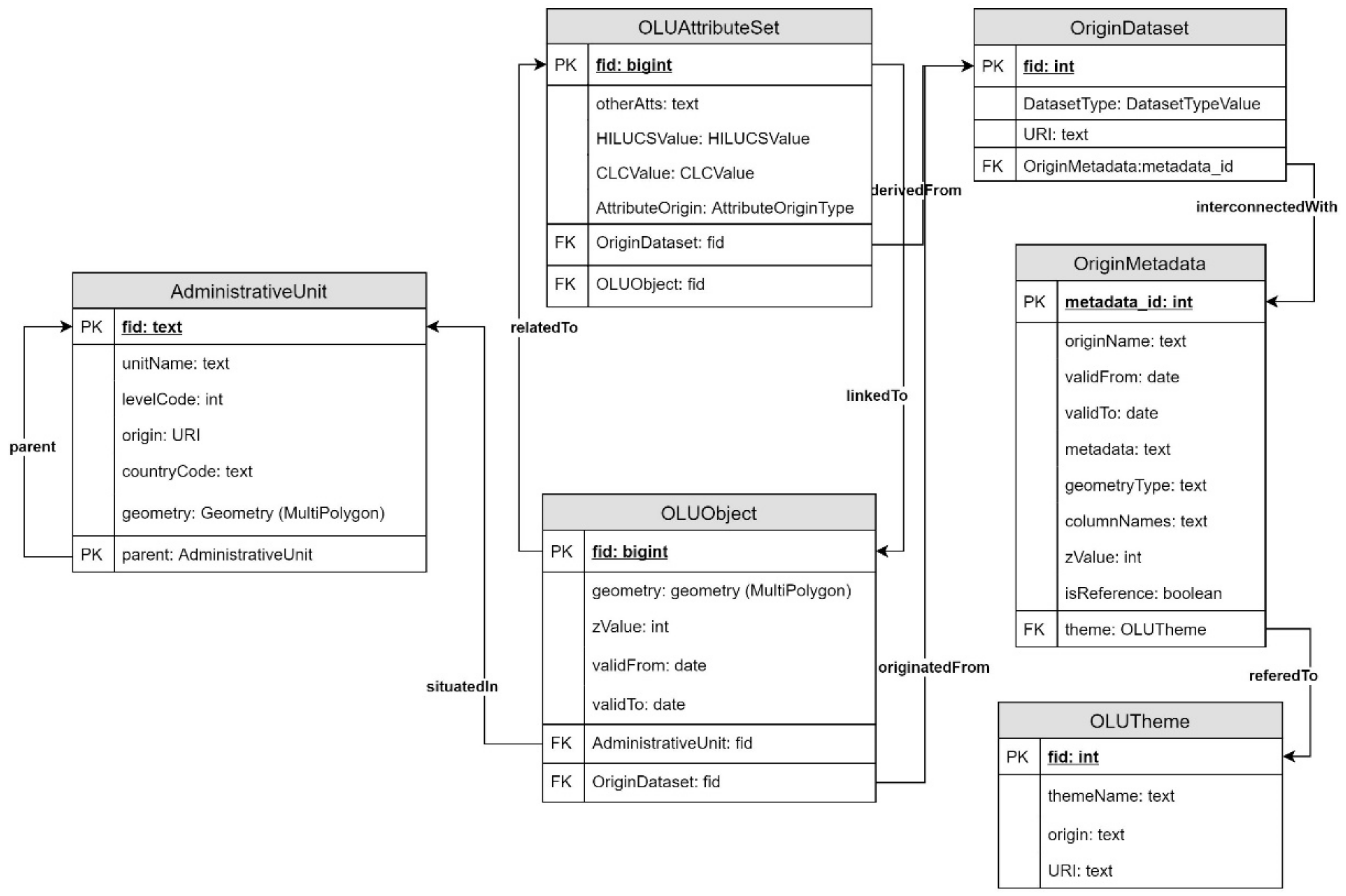
The main idea of the second version of the OLU data-model design is to flexibly incorporate thematic attributes from different domains by defining a hierarchical structure of reference geometries and variable adding of attributes to the OLU database. The main feature of the new data model is separation of the geometry and attributes of individual features of original datasets. This innovative separation approach provides flexibility and variability of the linkage of geometry with attributes from different sources and is the main difference from other LULC models The hierarchical structure of reference geometries provides a mechanism for the integration of spatial datasets of different scales to cover the region of interest with the most detailed data where available.
The main flexibility of the data model is provided by the mechanism of spatially based attribute joins. A spatially based attribute join means that attributes from thematic datasets are connected to reference geometries on the same level of the dataset hierarchy and that attributes of thematic datasets, as well as reference geometries, are propagated to datasets on a higher level of the data hierarchy. The data model is designed to utilize modern complex data types that do not limit the amount of stored data in one attribute. An important additional feature of OLU data model version 2.0 is the ordering of geometries based on levels of detail or scales of original datasets. Thematic attributes are linked only to OLU objects defined as reference geometries on the same level or higher in the hierarchy.
The extensibility of the attribute part of each OLU feature is ensured by the utilization of a data type implementing the list of key-value pairs to store data. Only mandatory attributes are stored directly in columns of the non-geometric attributes table as primitive data types. The remaining attributes from the original datasets are stored in the list of key-value pairs as a complex data type.
Individual OLU features are connected to the hierarchy of administrative units, consisting of administrative divisions of particular countries from country borders at the top level to the municipalities on the lowest level. The standard ISO 3166 Codes for the representation of names of countries and their subdivisions is used.
An additional processing step of the OLU database is designing individual spatio-temporal thematic views. These views provide an appropriate combination of OLU reference geometries with a defined subset of thematic attributes. The design of spatio-temporal thematic views is mainly an “on-demand” process and should be driven by particular scenarios or use cases. Spatio-temporal thematic views are designated for further analysis, processing, and visualization.

2.4. Data and Datasets

Filling up the OLU database with data depends not only on user needs but also on data quality, such as accuracy, completeness, consistency, validity, uniqueness, and timeliness 8. To stress one particular attribute of data used, the scale of the data or the extent of the data plays a crucial role as well, and there are local, national, continental, and global data that could be used, but that have different qualities in terms of the actual incorporation of them and their usability in the OLU database.
For our purposes, it is necessary to obtain datasets at different scales, which could be medium-scale, global, and detailed local scales that supplement large-scale ones where available (e.g., technical maps, cadastral maps, land records) to create a reference geometry. Then it would be possible to add thematic datasets that are linked to the reference geometry, according to the corresponding scales and spatial links, but also with more detailed ones. If there is no large-scale dataset available, the reference geometry of the OLU database could be built from datasets of lower resolution as well, but with the most detailed open-source vector scale available in the area of interest.
The problem here is on various fronts. To name a few of the most crucial ones, it is hard to obtain detailed large-scale data of high quality to create the reference geometry, and there could be inconsistency in data from the same dataset (e.g., in the digital cadastral map of the Czech Republic—there are still missing parts filled in with just a raster equivalent of this map). The gap must be supplemented with data from other datasets on the same topic. For example, where there is a road feature represented in the vector digital cadastral map but not represented in the raster equivalent of the map at a certain area, it could be supplemented with data from datasets such as Data50 9 or OpenStreetMap.
Nevertheless, the periodicity of the actualization of used datasets can differ, so there are efforts to use data that are frequently updated, such as EO or RS data, to fill in the OLU database. However, such data are usually small-scale raster data, but they can be vectorized for the creation of the reference geometry if needed. This topic is beyond the scope of this paper.

3. Results

This section presents the main results of the study related to the new version of the OLU database.

3.1. OLU Model Version 2

The main result of the development process of the OLU database is the new data model of the OLU. The data model of the OLU database was created during the modeling and designing phase, and the model addresses requirements that were collected, among others, during eight research projects in the last seven years. The UML class diagram defines the overall structure of the OLU data model (Figure 2). The first stable release of OLU data model 2.0 is labeled as 2.0.0 to be able incorporate minor updates and subsequent versions of the model. The conceptual model was verified by physical implementation in the PostgreSQL database system with PostGIS spatial extension.

3.2. Proof-of-Concept Implementation

Verification of the conceptual model of the OLU database was performed with its physical implementation. This was realized in PostgreSQL version 11 with spatial extension PostGIS version 3.1. Physical implementation checks the design of the conceptual model and confirms the attainability of requirements on the OLU model objects and their relations. The physical model in the form of SQL scripts for setting up an empty OLU database is presented in the GitHub 10 or Zenodo repository; the GitHub repository will be used for future versions of the OLU data model. Implementation in the PostgreSQL database system was filled with testing datasets to prove the workflow of the OLU data model and data integration.

3.3. Spatio-Temporal Thematic Views

The OLU data model allows users to create and export various spatio-temporal thematic views of the OLU database. The creation of such views was tested using different options—general views with land-use (HILUCS) and land-cover (CORINE) categories with z-values in the usual order of geometric precision—and then some specific options were chosen with filtering of features carried out by municipality belonging, temporal extent, and changing the z-value to fit the specific requirements of a theme. For instance, creating an agriculturally related thematic view could cause a switch of order between cadastral parcels and Land Parcel Information System (LPIS) fields, giving a bigger z-value to the latter. In addition, different techniques for defining values from the raster thematic dataset were tested (mean, mode values). They are employed according to the requirements of a theme.
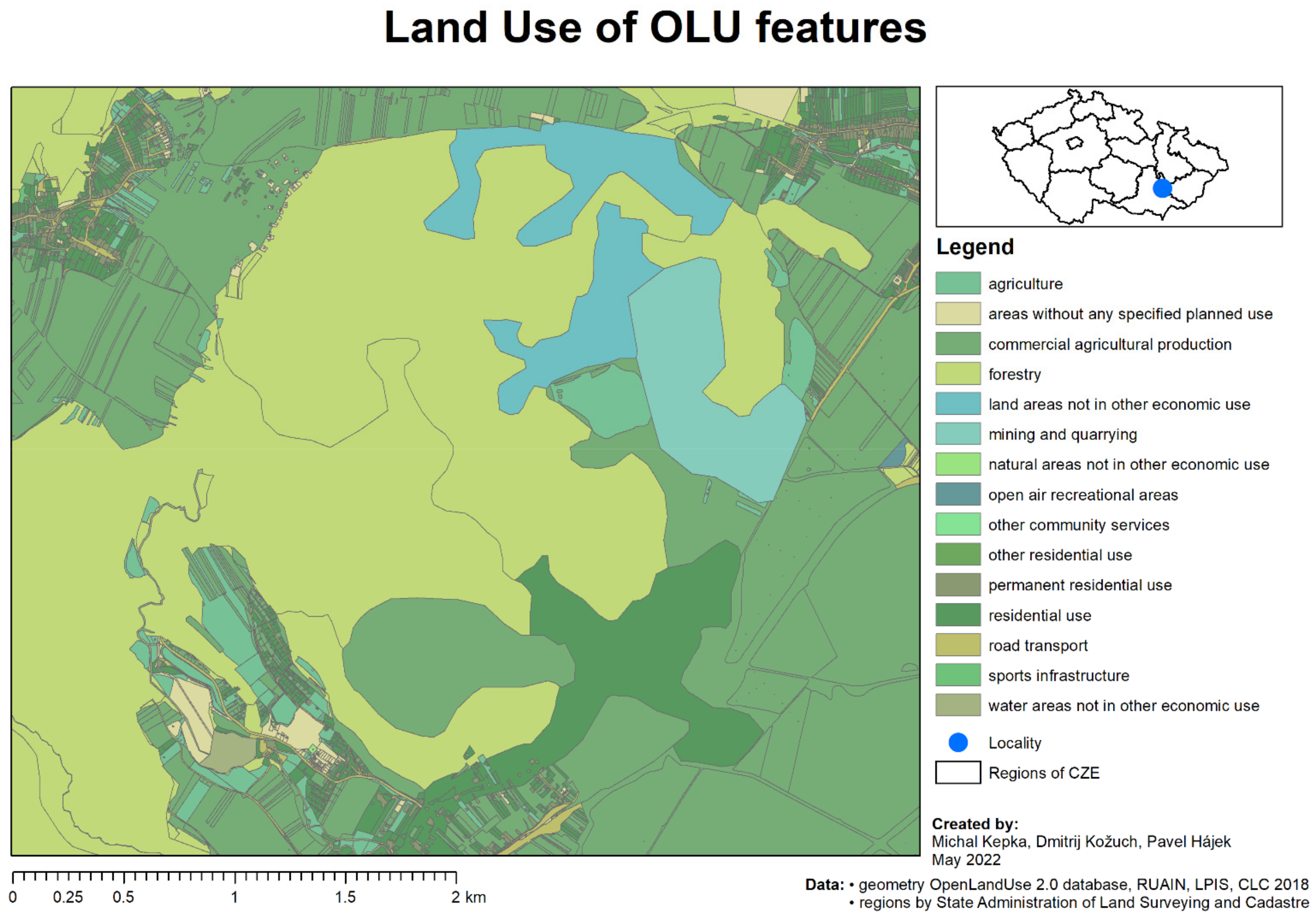
Figure 3 shows the base theme of land-use types on OLU reference geometries. The thematic and reference data came from Czech Digital Cadaster (RUIAN), LPIS, and CORINE Land Cover (CLC 2018), as well as the field blocks managed by the Rostěnice farm collaborating with Plan4All on various research topics, including precision farming.
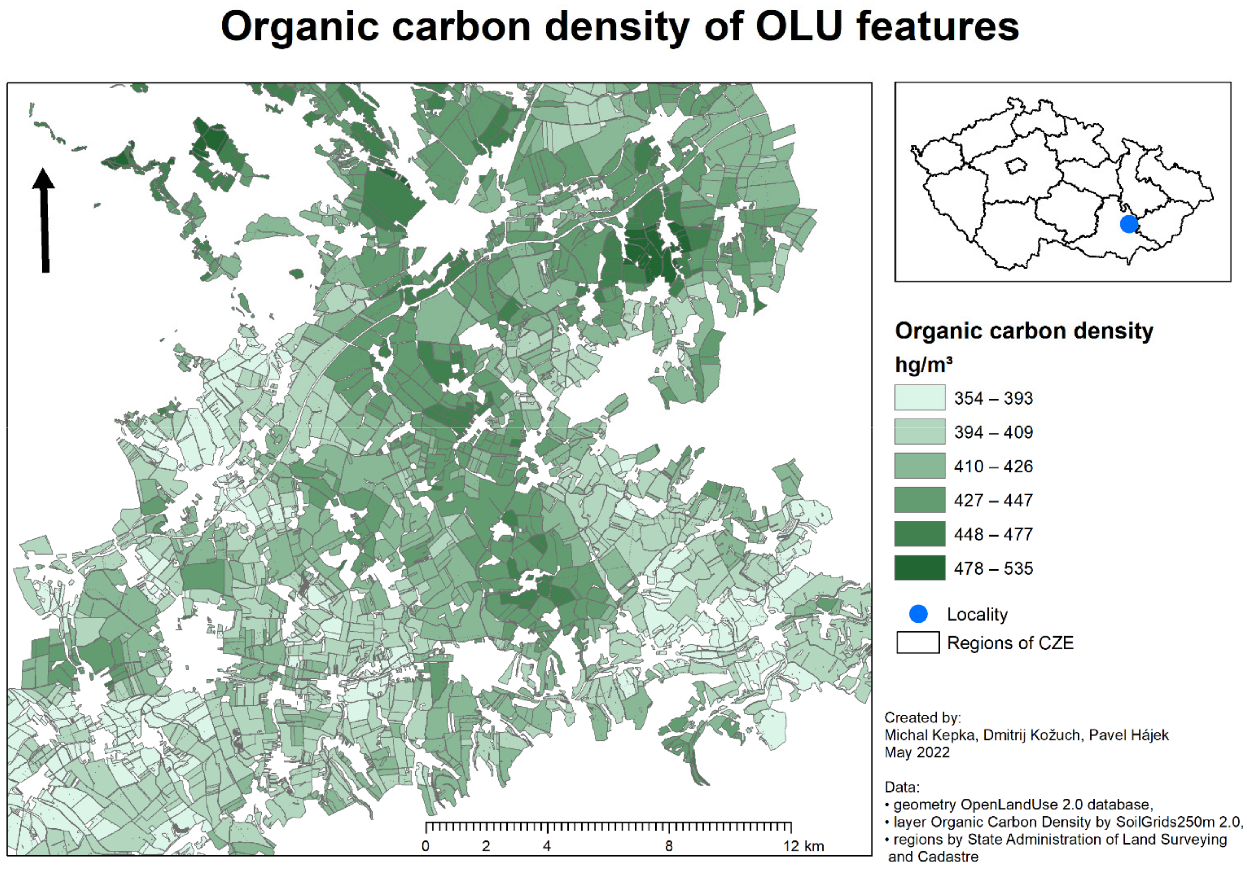
Figure 4 shows the organic carbon-density values on OLU reference geometries that are part of agricultural land use. The organic carbon density of the fields was derived from the SoilGrids database provided by the International Soil Reference and Information Centre 11 (ISRIC). Organic carbon density is one of the indicators of soil quality. The data could be useful for farmers for correlating soil quality and production management on the field.
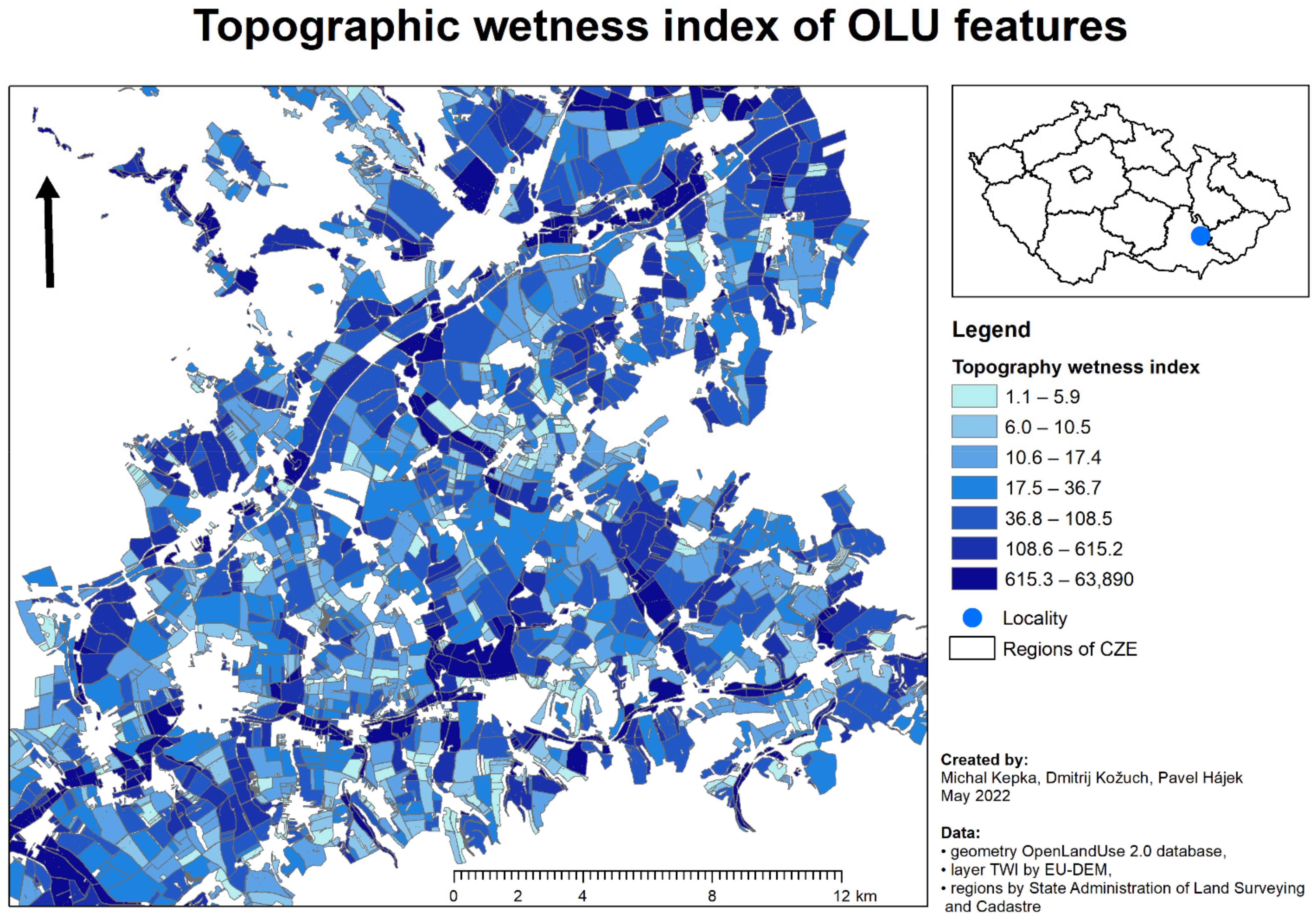
Figure 5 shows the topographic wetness index (TWI) on OLU fields that are part of agricultural land use. TWI is a wetness index that indicates topographic influence on water accumulation in the fields. These data were derived from the European Digital Elevation Model (EU-DEM) version 1.1 12, with the help of a pygeoprocessing library 13. The data are valuable for farmers because they help plan water management (watering and irrigation) on the field correctly.

3.4. Database Population

Earth observation data have good potential for enhancing the OLU database with classified LULC data in areas where established LULC sources are outdated, too coarse, or entirely missing. In conjunction with methods of image classification, they proved to be a reliable source for acquiring relevant land-cover and partial-land-use information [54,55]. Ref. [2] leveraged the modern Python library eo-learn with customized modifications and designed a processing pipeline to classify multi-temporal Sentinel-2 images according to the Czech cadaster. Although this classification was not semantically rich, it showed good accuracy, and as such it could present a viable LULC input to problematic areas within OLU. Very-high-resolution data from other sensors and advanced classification methods, such as neural networks and object-based image analysis (OBIA), can further improve classifications [56,57] and strengthen cohesion with already-utilized sources in OLU.
We henceforth summarize the terms and definitions that are used in the context of OLU database version 2.0.
  • The OLU database is a general description of the product of the activity. It consists of the data model, the implemented database with data, and visualization of data in the form of maps.
  • The OLU Complex view is a portrayal of the OLU database in the highest level of detail with all thematic attributes available in the database.
  • The OLU reference map is a portrayal of the OLU database in the highest level of detail without thematic attributes.
  • The OLU spatio-temporal thematic view is a portrayal of the OLU database by defined order of reference geometries and attributes by defined theme and time epoch.
  • A map composition is a visualization of a particular OLU attainability.

4. Discussion

Four major topics are discussed in detail in line with the scope and extent of the limitations of this paper. These four major topics aim at a discussion of the conceptual level (definition of multi-level geometries and attributes, integration of data sources beyond remote sensing, integration into DestinE), data quality (with emphasis on completeness and positional accuracy), the relation of OLU to DestinE, and licensing issues.

4.1. Definition of Multi-Level Geometries and Attributes

Contemporary approaches, like those in [25,43,44], have fixed links between geometries and attributes of feature instances. For example, two new objects are created when a feature (like a piece of arable land) is divided into two new follow-up features (like a reduced piece of arable land and the supplementary geometry of newly built-up area). Such an approach relies on the application logic of a developed system, as a dataset does not provide relevant information related to the linkage of these three spatial features (an original piece of arable land, a reduced piece of arable land, and the supplementary geometry of newly built-up area) over time.
The presented approach, on the contrary, defines hierarchies of geometries and attributes from the following points of view:
  • Temporal, as described above, through an example of a piece of arable land. Such an approach enables the depiction of a life cycle of a feature, as also discussed in the INSPIRE Data Specifications themes of LULC.
  • Level of detail (LoD), as the hierarchy is built by default based on the LULC layers from original (underlying) databases. Superior, lower, and equivalent LoDs are identified.
  • A combination of the temporal and LoD points of view provides the following benefits:
  • Minimizes redundancies: Links between geometry and attributes are conducted only at the level of database relations, not data themselves.
  • Complex life cycle: The whole processing history up to a spatial-feature level is stored by default, in contrast to “time-instance snapshots” common in other relevant approaches.
  • Slices of LULC data: Temporal and LoD points of view are conceptually like “hyperspectral cubes” common in the remote-sensing scientific domain.

4.2. LULC Integration beyond Remote-Sensing Datasets

The LULC information in most research projects has been derived from remote-sensing data [2,11,12,16,17,18,19,22,25]. Derivation of LULC information from other information resources seems to be an exception. For instance, [43,44] took the OSM as the primary information resource.
The concept presented in this paper combines both approaches, as it adopts the most detailed (vector) information from (1) cadastral datasets or Land Parcel Identification Systems (LPIS) and (2) medium-scale datasets like Urban Atlas (UA) or CORINE Land Cover (CLC). Moreover, our approach combines the adopted datasets with remote-sensing-based data, as described in [2], and creates connections by default to administration units and on demand to cadastral parcels, soil, weather, topography, or the Land Parcel Identification System (LPIS).
The approach presented in this paper builds on the fundamental premise that neither remote-sensing-based LULC classifications nor other kinds of adopted (mostly vector) data are 100% sufficient. The combination of remote sensing and other kinds of data provides a filtering basis in the OLU to identify areas that need to be verified, known as “suspicious areas.” These “suspicious areas” are then evaluated for their heterogeneity within the underlying datasets and, in particular, with pixel heterogeneity in the remote-sensing data. Such a filtering follows threshold-based modeling based on the percentage cover of pixel heterogeneity (neighboring pixels in a given spatial extent). Pixel heterogeneity of a feature is generally measured with the coefficient of variance, and thresholds are set individually according to the requirements for the theme.

4.3. Completeness and Positional Accuracy

Data-quality aspects of created LULC datasets are a subject of all the state-of-the-art activities presented win this paper. Completeness and positional accuracy are the two major data-quality interests of both LULC data producers and users. For more details, see [2,28].
When considering the ISO 19,157 standard, the following data-quality elements should be considered: (1) Completeness Commission, most often expressed as a ratio between existing and missing items in an LULC dataset, and (2) Absolute External Positional Accuracy, most commonly expressed through the root mean square error (RMSE) in 2D. These data-quality elements have become crucial, as the OLU database allows various input datasets (contrary to the situation a decade ago when only specific input datasets were allowed). Evaluations of the Completeness Commission and Absolute External Positional Accuracy have become a logical step that is now being conducted. Similar to existing approaches, the greatest bottleneck is tightened to the “ground truth” data, i.e., a reference for data-quality evaluations.
The spatial accuracy is evaluated in the OLU database through cadastral data, considered the most accurate from a geometry point of view. LPIS data are the second choice, commonly used when cadastral data are not available. The spatial accuracy of the OLU database is often evaluated through RMSE, but also in 3D. Some 3D-based evaluations are provided for terrain, where the Copernicus EU-DEM is being used as the “ground truth.” The ongoing activities will also deal with another data-quality element, the Relative Positional Internal Accuracy, as defined in ISO 19157. Such a data-quality element will enable an evaluation of the positional homogeneity of LULC data on a specific LoD. In other words, it will also provide an answer to the following question: How much is the positional accuracy consistency of the OLU dataset influenced by various input datasets?
Thematic accuracy is evaluated through orthophotos that are considered the most accurate from a thematic-credibility point of view. However, orthophotos are not applicable for verification of all the spatial features in the LULC dataset, like a road segment within a forest.

4.4. Licensing Issues for the OLU Database

Last but not least is the licensing topic. Publishing data openly without major restrictions is an important aspect of DestinE and its further reuse by various users. The ELF project 14 created a valuable dataset from the technical and organizational perspectives. However, the use of this product was paralyzed by licensing agreements that comprised restrictions from around 40 input (original) licensing agreements. Consequently, the basic INSPIRE license for open publication of spatial data 15 cannot be used in these situations. DestinE should address such a challenge as an INSPIRE follow-up. Data included in the OLU database are open. Some of them are from the public domain, i.e., they are not protected by any copyright or restrictions and may be freely copied, shared, altered, and reused by anyone. However, some data have various open licenses that are not necessarily compatible. Creating a new database by combining data with different open licenses can become problematic. An example is using the OpenStreetMap (OSM) with the ODbL 16 license as one of the OLU data sources. The ODbL license does not allow users to add additional content to the OSM data unless their licenses are compatible. This makes combining open data difficult, considering also the expertise needed to fully understand all the different conditions and restrictions imposed by various open licenses.

5. Conclusions

The presented research provides a multi-scale open database of LULC information. In contrast to related work, the OLU database does not rely solely on one data source, like remote-sensing data classification. Instead, it combines all the relevant datasets with open licenses, including data derived from remote sensing, into one coherent vector dataset. Moreover, the novel spatio-temporal approach also lies in modular views of the OLU database, reflecting the desired scope and application. The presented outcomes originate from the requirements identified within eight international research projects between 2013 and 2021. A formal definition of the developed data model through UML class diagrams, a feature catalogue based on ISO 19,110 and SQL scripts for setting up the OLU database, are the key achievements of the presented study. All these achievements remain publicly available to be adopted by different communities.
The presented development is understood as version 2.0, a stable release. As such, the OLU database is intended for application in research and development projects and as a foundation for digital-twin initiatives and frameworks. The outcomes are designed as a cornerstone of the DestinE initiative to develop a high-precision digital model of the earth to monitor and simulate natural and human activities. The conclusions from the DestinE Validation workshop held in November 2020 [8] mention that DestinE should capitalize on the experience gained from other relevant European initiatives, and a wider range of data sources and user needs should be taken into account. The OLU database breaks the traditional concept of a dataset restricted to a single spatial-data theme by combining data across different themes. OLU draws from experience and user needs from multiple research and development projects and is openly provided to wider communities.
Future work on the OLU database includes regular updates, an extension of the content in finer levels of detail, data-quality evaluation, sorting out licensing in different regions, and building a community to support the improvement and reuse of the database.

Author Contributions

M.K., P.H., D.K., T.Ř., T.M., K.C. and M.K.V. designed the research; M.K., P.H., D.K. and T.Ř. performed the research; M.K., D.K. and J.C. carried out the coding and programming; P.H., D.K. and T.Ř. analyzed the data; and M.K., P.H., D.K., T.Ř., T.M., K.C. and M.K.V. wrote the paper. All authors have read and agreed to the published version of the manuscript.

Funding

This paper is part of a project that has received co-funding from the 7th Framework Programme of the European Commission under grant agreement No. 296282, called “A service platform for aggregation, processing and analysis of urban and regional planning data” (Plan4business). This paper is part of a project that has received funding from the European Union’s Horizon 2020 Research and Innovation Programme under grant agreement No. 732064, called “Data-driven Bioeconomy” (DataBio). This paper is part of a project that has received funding from the European Union’s Competitiveness and Innovation Framework Programme under grant agreement No. 621129, called “Uptake of Open Geographic Information Through Innovative Services Based on Linked Data” (SDI4Apps). This paper is part of a project that has received funding from the European Union’s Competitiveness and Innovation Framework Programme under grant agreement No. 621074, called “Farm-Oriented Open Data in Europe” (FOODIE). This paper is part of a project that has received funding from the European Union’s Horizon 2020 Research and Innovation Programme under grant agreement No. 777549, called “European e-Infrastructure for Extreme Data Analytics in Sustainable Development” (EUXDAT). This paper is part of a project that has received funding from the European Union’s Horizon 2020 Research and Innovation Programme under grant agreement No. 818496, called “Future Oriented Collaborative Policy Development for Rural Areas and People” (POLIRURAL). This paper is part of a project that has received funding from the European Union’s Horizon 2020 Research and Innovation Programme under grant agreement No. 818346, called “Sino-EU Soil Observatory for Intelligent Land Use Management” (SIEUSOIL).

Institutional Review Board Statement

Not applicable.

Informed Consent Statement

Not applicable.

Data Availability Statement

Description of the new OLU data model with the feature catalogue and SQL scripts for setting up the empty database can be found in the Zenodo repository: https://doi.org/10.5281/zenodo.6484843, accessed on 24 July 2021.

Conflicts of Interest

The authors declare no conflict of interest.

Notes

1
2
3
4
Uptake of open geographic information through innovative services based on linked data. SDI4Apps. Cordis: https://cordis.europa.eu/project/id/621129.
5
OpenTransportNet. OTN. Cordis: https://cordis.europa.eu/project/id/620533.
6
Farm-Oriented Open Data in Europe. FOODIE. Cordis: https://cordis.europa.eu/project/id/621074.
7
8
9
Data50 is a geographical model of the territory of the Czech Republic.
10
11
12
13
14
15
16

References

  1. Verburg, P.H.; van de Steeg, J.; Veldkamp, A.; Willemen, L. From land cover change to land function dynamics: A major challenge to improve land characterization. J. Environ. Manag. 2009, 90, 1327–1335. [Google Scholar] [CrossRef]
  2. Řezník, T.; Chytrý, J.; Trojanová, K. Machine Learning-Based Processing Proof-of-Concept Pipeline for Semi-Automatic Sentinel-2 Imagery Download, Cloudiness Filtering, Classifications, and Updates of Open Land Use/Land Cover Datasets. ISPRS Int. J. Geo-Inf. 2021, 10, 102. [Google Scholar] [CrossRef]
  3. FAO. State of the World’s Forests; Food and Agriculture Organization: Rome, Italy, 1997; 200p. [Google Scholar]
  4. FAO/UNEP. Terminology for Integrated Resources Planning and Management; Food and Agriculture Organization: Rome, Italy; United Nations Environmental Programme: Nairobi, Kenya, 1999. [Google Scholar]
  5. European Parliament, Council of the European Union. Directive 2007/2/EC of the European Parliament and of the Council of 14 March 2007 Establishing an Infrastructure for Spatial Information in the European Community (INSPIRE). Off. J. Eur. Union 2007, 108, 1–14. [Google Scholar]
  6. European Commission. A European Strategy for Data (COM/2020/66). Available online: https://eur-lex.europa.eu/legal-content/EN/TXT/?uri=CELEX:52020DC0066 (accessed on 19 February 2020).
  7. European Commission. Policies: Destination Earth. Available online: https://digital-strategy.ec.europa.eu/en/policies/destination-earth (accessed on 14 June 2021).
  8. European Commission. Destination Earth (DestinE) Architecture Validation Workshop, 26th of November 2020, Summary Report. Available online: https://ec.europa.eu/newsroom/dae/redirection/document/73317 (accessed on 20 September 2021).
  9. Nativi, S.; Craglia, M.; Destination Earth: Use Cases Analysis. European Commission, Joint Research Centre, Publications Office. 2020. Available online: https://data.europa.eu/doi/10.2760/17457 (accessed on 25 September 2021).
  10. Mildorf, T.; Charvát, K.; Ježek, J.; Templer, S.; Malewski, C. Open Land Use Map. AGRIS On-Line Pap. Econ. Inform. 2014, 6, 81–88. [Google Scholar] [CrossRef]
  11. Jansen, L.J.M. Harmonization of land use class sets to facilitate compatibility and comparability of data across space and time. J. Land Use Sci. 2006, 1, 127–156. [Google Scholar] [CrossRef]
  12. Yang, H.; Li, S.; Chen, J.; Zhang, X.; Xu, S. The Standardization and Harmonization of Land Cover Classification Systems towards Harmonized Datasets: A Review. ISPRS Int. J. Geo-Inf. 2017, 6, 154. [Google Scholar] [CrossRef]
  13. Hardy, E.E.; Anderson, J.R. A Land-Use Classification System for Use with Remote-Sensor Data. In Proceedings of the Conference on Machine Processing of Remotely Sensed Data, West Lafayette, IN, USA, 16–18 October 1973; pp. 16–18. [Google Scholar]
  14. Anderson, J.R.; Hardy, E.E.; Roach, J.T.; Witmer, R.E. A Land Use and Land Cover Classification System for Use with Remote Sensor Data; US Government Printing Office: Washington, DC, USA, 1976.
  15. Townshend, J.R.G. MODIS enhanced land cover and land cover change product: Algorithm theoretical basis documents (ATBD), version 2.0. Int. J. Remote Sens. 1999, 13, 1319–1328. [Google Scholar] [CrossRef]
  16. Vogelmann, J.E.; Howard, S.M.; Yang, L.M.; Larson, C.R.; Wylie, B.K.; Van Driel, N. Completion of the 1990s National Land Cover Data Set for the conterminous United States from Landsat Thematic Mapper data and ancillary data sources. Photogramm. Eng. Remote Sens. 2001, 67, 650–652. [Google Scholar] [CrossRef]
  17. Homer, C.; Dewitz, J.; Fry, J.; Coan, M.; Hossain, N.; Larson, C.; Wickham, J. Completion of the 2001 national land cover database for the counterminous United States. Photogramm. Eng. Remote Sens. 2007, 73, 337. [Google Scholar]
  18. U.S. Geological Survey. U.S. Geological Survey Gap Analysis Program, 20160513. In GAP/LANDFIRE National Terrestrial Ecosystems 2011; U.S. Geological Survey: Reston, VA, USA, 2016. [Google Scholar] [CrossRef]
  19. McConnell, W.; Moran, E. Meeting in the Middle: The Challenge of Meso-Level Integration. Land Use Policy 2002, 19, 99–101. [Google Scholar] [CrossRef]
  20. Di Gregorio, A.; Latham, J. Africover Land Cover Classification and Mapping project. In Encyclopedia of Life Support Systems (EOLSS); Werheve, W., Ed.; ELOSS: Paris, France, 2003; pp. 236–254. ISBN 978-1-84826-235-5. [Google Scholar]
  21. Herold, M.; Schmullius, C. Report on the harmonization of global and regional land cover products. GOFCGOLD Report No. 20. In Proceedings of the Workshop at FAO, Rome, Italy, 14–16 July 2004. [Google Scholar]
  22. FAO. Global Land Cover SHARE (GLC-SHARE) Database. Beta-Release Version 1.0 Prepared by John Latham, Renato Cumani, Ilaria Rosati and Mario Bloise. 2014. Available online: http://www.fao.org/uploads/media/glc-share-doc.pdf (accessed on 5 October 2021).
  23. FAO. Programme for the 1990 World Census of Agriculture. In FAO Statistical Development Series 2; Food and Agriculture Organization: Rome, Italy, 1986; 90p. [Google Scholar]
  24. FAO. Planning for Sustainable Use of Land Resources: Towards a New Approach; Land and Water Bulletin 2; Food and Agriculture Organization: Rome, Italy, 1995; 60p. [Google Scholar]
  25. Büttner, G.; Kosztra, B.; Sousa, A.; Steenmans, C. CLC2006: Mapping land cover of Europe under GMES. In Proceedings of the 29th Symposium of the European Association of Remote Sensing Laboratories; Manakos, I., Kalaitzidis, C., Eds.; IOS Press: Chania, Greece, 2010; pp. 26–34. [Google Scholar]
  26. ESA. CORINE Land Cover. Available online: https://land.copernicus.eu/pan-european/corine-land-cover (accessed on 26 May 2021).
  27. Lavalle, C.; Demicheli, L.; Kasanko, M.; McCormick, N.; Barredo, J.; Turchini, M.; Martins, I.P. Towards an Urban Atlas; European Environment Agency: Copenhagen, Denmark, 2002. [Google Scholar]
  28. Kliment, M.; Kočica, J.; Kliment, T. Land Use Dataset Collection And Publication Based On Lucas And Hilucs. Acta Hortic. Regiotect. 2015, 17, 52–59. [Google Scholar] [CrossRef] [Green Version]
  29. Hallin-Pihlatie, L. INSPIRE Land Cover and Land Use Data Specifications. 2018. Presentation. Available online: https://eurogeographics.org/wp-content/uploads/2018/04/2.-INSPIRE-Specification_Lena_0.pdf (accessed on 1 October 2021).
  30. Forman, R.T.T.; Godron, M. Landscape Ecology; John Wiley: New York, NY, USA, 1986. [Google Scholar]
  31. Farina, A.; Belgrano, A. The Eco-field Hypothesis: Toward a Cognitive Landscape. Landsc. Ecol. 2006, 21, 5–17. [Google Scholar] [CrossRef]
  32. Hazeu, G.W. Land use mapping and monitoring in the Netherlands (LGN5). In 2nd EARSeL Workshop on Land Use and Land Cover; University of Bonn: Bonn, Germany, 2006; pp. 28–30. [Google Scholar]
  33. Goldewijk, K.K.; Beusen, A.; Doelman, J.; Stehfest, E. Anthropogenic land use estimates for the Holocene—HYDE 3.2. Earth Syst. Sci. Data 2017, 9, 927–953. [Google Scholar] [CrossRef]
  34. CIESIN (Center for International Earth Science Information Network). Global Rural-Urban Mapping Project (GRUMP) Alpha Version; Columbia University: New York, NY, USA, 2004. [Google Scholar]
  35. European Space Agency. Land Cover CCI Product User Guide Version 2.0; Université Catholique de Louvain: Louvain-la-Neuve, Belgium, 2017. Available online: http://maps.elie.ucl.ac.be/CCI/viewer/download/ESACCI-LC-Ph2-PUGv2_2.0.pdf (accessed on 21 November 2021).
  36. Arino, O.; Gross, D.; Ranera, F.; Leroy, M.; Bicheron, P.; Brockman, C.; Defourny, P.; Vancutsem, C.; Achard, F.; Durieux, L.; et al. GlobCover: ESA Service for Global Land Cover from MERIS. In Proceedings of the 2007 IEEE International Geoscience and Remote Sensing Symposium, Barcelona, Spain, 23–27 July 2007; pp. 2412–2415. [Google Scholar] [CrossRef]
  37. Liu, J.; Liu, M.; Deng, X.; Zhuang, D.; Zhang, Z.; Luo, D. The land use and land cover change database and its relative studies in China. J. Geogr. Sci. 2002, 12, 275–282. [Google Scholar] [CrossRef]
  38. Gong, P.; Wang, J.; Yu, L.; Zhao, Y.; Zhao, Y.; Liang, L.; Niu, Z.; Huang, X.; Fu, H.; Liu, S.; et al. Finer resolution observation and monitoring of global land cover: First mapping results with Landsat TM and ETM+ data. Int. J. Remote Sens. 2013, 34, 2607–2654. [Google Scholar] [CrossRef]
  39. Jun, C.; Ban, Y.; Li, S. Open access to Earth land-cover map. Nature 2014, 514, 434. [Google Scholar] [CrossRef]
  40. Zanaga, D.; Van De Kerchove, R.; De Keersmaecker, W.; Souverijns, N.; Brockmann, C.; Quast, R.; Wevers, J.; Grosu, A.; Paccini, A.; Vergnaud, S.; et al. ESA WorldCover 10 m 2020 v100 (Version v100) [Data set]. Zenodo 2021. [Google Scholar] [CrossRef]
  41. Karra, K.; Kontgis, C.; Statman-Weil, Z.; Mazzariello, J.C.; Mathis, M.; Brumby, S.P. Global land use/land cover with Sentinel 2 and deep learning. In Proceedings of the 2021 IEEE International Geoscience and Remote Sensing Symposium IGARSS, Barcelona, Spain, 23–27 July 2021; pp. 4704–4707. [Google Scholar] [CrossRef]
  42. Briassoulis, H. Analysis of Land Use Change: Theoretical and Modeling Approaches, 2nd ed. Edited by Scott Loveridge and Randall Jackson. WVU Research Repository. 2020. Available online: https://researchrepository.wvu.edu/rri-web-book/3/ (accessed on 5 November 2021).
  43. Patriarca, J.; Fonte, C.; Estima, J.; de Almeida, J.-P.E.D.; Cardoso, A. Automatic conversion of OSM data into LULC maps: Comparing FOSS4G based approaches towards an enhanced performance. Open Geospat. Data Softw. Stand. 2019, 4, 11. [Google Scholar] [CrossRef]
  44. OSM. Landuse Landcover. 2020. Available online: https://osmlanduse.org/#12/8.7/49.4/0/ (accessed on 10 September 2021).
  45. Schultz, M.; Voss, J.; Auer, M.; Carter, S.; Zipf, A. Open land cover from OpenStreetMap and remote sensing. Int. J. Appl. Earth Obs. Geoinform. 2017, 63, 206–213. [Google Scholar] [CrossRef]
  46. Ježek, J.; Mildorf, T.; Charvát, K.; Charvát, K. The Plan4business Approach to Transfer Open Data into Real Estate Businesses. In International Symposium on Environmental Software Systems; Hřebíček, J., Schimak, G., Kubásek, M., Rizzoli, A.E., Eds.; Springer: Berlin/Heidelberg, Germany, 2013; Volume 413. [Google Scholar] [CrossRef]
  47. Mildorf, T.; Ježek, J.; Kepka, M.; Čerba, O.; Klien, E.; Templer, S.; Charvát, K. Plan4business-a service platform for aggregation, processing and analysis of urban and regional planning data. Int. Arch. Photogramm. Remote Sens. Spat. Inf.Sci. 2013, 4, W1. [Google Scholar] [CrossRef]
  48. Charvat, K.; Esbri, M.A.; Mayer, W.; Campos, A.; Palma, R.; Krivanek, Z. FOODIE-Open data for agriculture. In 2014 IST-Africa Conference Proceedings; IEEE: Piscataway, NJ, USA, 2014; pp. 1–9. [Google Scholar]
  49. Palma, R.; Reznik, T.; Esbrí, M.; Charvat, K.; Mazurek, C. An INSPIRE-Based Vocabulary for the Publication of Agricultural Linked Data. In International Experiences and Directions Workshop on OWL; Tamma, V., Dragoni, M., Gonçalves, R., Ławrynowicz, A., Eds.; Springer: Cham, Switzerland, 2016; Volume 9557. [Google Scholar] [CrossRef]
  50. Charvat, K.; Reznik, T.; Lukas, V.; Charvat, K., Jr.; Jedlicka, K.; Palma, R.; Berzins, R. Advanced Visualisation of Big Data for Agriculture as Part of DataBio Development. In Proceedings of the IGARSS 2018—2018 IEEE International Geoscience and Remote Sensing Symposium, Valencia, Spain, 22–27 July 2018; pp. 415–418. [Google Scholar] [CrossRef]
  51. Jedlička, K.; , Kepka, M., Esbrí, M.A., Hájek, P., Doubková, M., Moshou, D., Gutbrod, K., Kozukh, D. EUXDAT project deliverable—D2.5 Updated Report on e-Infrastructure Requirements v2, 9.7.2019. Available online: https://www.euxdat.eu/wp-content/uploads/2020/10/EUXDAT_D2.5_Description_of_Proposed_Pilots_and_Requirements_v1.0.pdf (accessed on 12 October 2021).
  52. Ulman, M.; Šimek, P.; Masner, J.; Kogut, P.; Löytty, T.; Crehan, P.; Sabbatini, T. Towards Future Oriented Collaborative Policy Development for Rural Areas and People. AGRIS On-Line Pap. Econ. Inform. 2020, 12, 111–124. [Google Scholar] [CrossRef]
  53. Mildorf, T.; , Hájek, P., Kepka, M., Kozhuch, D., Gobin, A., Vuolo, F., Palma, R., Zhang, G., Song, X. SIEUSOIL Project Deliverable—D2.3 Tool Development for Correlating Land Use Modelling and Soil Quality. Available online: https://drive.google.com/file/d/1d0u5pjc0qi7B2pLmL_Cap6OhqzH4A8D5/view?usp=sharing. (accessed on 30 November 2020).
  54. Phiri, D.; Simwanda, M.; Salekin, S.; Nyirenda, V.R.; Murayama, Y.; Ranagalage, M. Sentinel-2 Data for Land Cover/Use Mapping: A Review. Remote Sens. 2020, 12, 2291. [Google Scholar] [CrossRef]
  55. Zheng, H.; Du, P.; Chen, J.; Xia, J.; Li, E.; Xu, Z.; Li, X.; Yokoya, N. Performance Evaluation of Downscaling Sentinel-2 Imagery for Land Use and Land Cover Classification by Spectral-Spatial Features. Remote Sens. 2017, 9, 1274. [Google Scholar] [CrossRef]
  56. Myint, S.W.; Gober, P.; Brazel, A.; Grossman-Clarke, S.; Weng, Q. Per-pixel vs. object-based classification of urban land cover extraction using high spatial resolution imagery. Remote Sens. Environ. 2011, 115, 1145–1161. [Google Scholar] [CrossRef]
  57. Längkvist, M.; Kiselev, A.; Alirezaie, M.; Loutfi, A. Classification and Segmentation of Satellite Orthoimagery Using Convolutional Neural Networks. Remote Sens. 2016, 8, 329. [Google Scholar] [CrossRef] [Green Version]
Figure 1. Initial OLU data model and mapping attributes between the OLU model and INSPIRE ExistingLandUseObject.
Land 11 01552 g001
Figure 2. Diagram of OLU data model version 2.0.0.
Land 11 01552 g002
Figure 3. Example of a visualization of the land-use types on OLU reference geometries.
Land 11 01552 g003
Figure 4. Example of a visualization of the organic carbon density on OLU reference geometries.
Land 11 01552 g004
Figure 5. Example of a visualization of the topographic wetness index on OLU reference geometries.
Land 11 01552 g005
Publisher’s Note: MDPI stays neutral with regard to jurisdictional claims in published maps and institutional affiliations.