Article

An Evaluation of the National Program of Systematic Land Registration in Romania Using the Fit for Purpose Spatial Framework Principles

by
Vlad Păunescu
1,
Divyani Kohli
2,
Alexandru-Iulian Iliescu
1,
Mircea-Emil Nap
3,
Elemer-Emanuel Șuba
3,* and
Tudor Sălăgean
3
1
University of Agronomic Sciences and Veterinary Medicine of Bucharest, 011464 Bucharest, Romania
2
Faculty of GeoInformation and Science & Earth Observation, ITC, 7514 AE Enschede, The Netherlands
3
University of Agricultural Sciences and Veterinary Medicine Cluj-Napoca, 400372 Cluj-Napoca, Romania
*
Author to whom correspondence should be addressed.
Land 2022, 11(9), 1502; https://doi.org/10.3390/land11091502
Submission received: 28 July 2022 / Revised: 2 September 2022 / Accepted: 5 September 2022 / Published: 7 September 2022

Abstract

:
The National Program of Systematic Land Registration aims to register all land property in Romania by 2023. The goal has proven difficult to achieve, as by June 2022 only 4% of the localities in the country were completed. The aim of this research is to find the similarities and differences between the fit for purpose principles of land administration for the spatial framework and the practices in The Romanian National Program of Systematic Land Registration. This is the first study that analyzes the Romanian land registration program through the lens of the fit for purpose concept. The research shows that there are similarities with the fit for purpose spatial framework principles for the use of aerial images and the participatory nature of the process. However, The National Program of Systematic Land Registration uses almost exclusively fixed boundaries and does not have different standards of accuracy and procedures for incremental improvement. Registering the parcels earlier in the process, flexibility for accuracy, and technical standards and regulations for incremental improvement of the system can speed up the registration in a fit for purpose manner.

1. Introduction

1.1. Background of the Research

Reducing poverty, food security, gender equality, and environmental protection are goals that the UN set to achieve in terms of sustainable development [1]. Accomplishment of most of these goals implies establishing an official connection between the people and the land they are working on. For this reason, countries use land administration systems to determine the ownership, value, and use of land, paving the way for land management strategies and land policies [2,3,4]. Land registration and cadaster are at the foundation of a land administration system [3]. That is why many land administration projects have been implemented in a number of countries from the developing world [5,6,7].
Until 1989, most of the countries in Central and Eastern Europe had a centrally planned economy with most of the land owned by the state. With the fall of the Iron Courtin, land reforms with the aim to redistribute the land back to the people took place in almost every country in the region [8]. In Romania, the approach was direct restitution by giving back 10 hectares for the people that owned land or their heirs before the nationalization process. Successive legislation upgraded the surface to 50 hectares. However, the application of these laws was characterized by indolence and corruption, generating much litigation [9]. These laws also led to extreme fragmentation with the dissolution of over 3200 state farms and the redistribution of over 9 million hectares [10]. A need for a reliable system that could register all this land arose.
After the Romanian Revolution of 1989, land registration was performed sporadically. In 2004, The National Agency for Cadastre and Land Registration (ANCPI) was formed. This institution reunites the technical and legal components of the system in one institution. The Romanian land administration system provides data about: spatial position of the land parcels and buildings, surfaces, land use, owners and legal rights.
In 2015, The National Program of Systematic Land Registration in Romania (PNCCF) was launched by ANCPI with the aim of registering all localities in the country by 2023. However, only 4% of localities have been registered until June 2022. It can be affirmed that the objective of the project is very improbable to be attained in the timeframe proposed.
In the Romanian land administration system, ANCPI is responsible for designing the strategies and policies, the local cadastral offices (OCPI) are responsible for registering the land and keeping the cadaster registers, while the work of data gathering and uploading the data in the system is performed by the private sector through certified personnel and certified companies.
To complete land registration for a certain locality, there are compulsory steps that have to be followed. These steps include a participatory process. The stages are enumerated in the technical specifications, laws, and regulations [11,12,13] and are as follows:
Information campaign. The inhabitants are informed that land registration will take place in their locality
Technical work. Consists in identifying the limits of parcels and gathering the titles from the owners. The process is participatory with the owners required to identify the boundaries of the parcels
Submitting the work to OCPI for verification. The cadastral office checks at least 20% of the parcels and rejects the work if 20% does not correspond to standards
Public display of the work. The people verify themselves the parcels and submit complaints if they consider necessary
Complaints solving. OCPI analyzes the petitions and issues solutions
The cadastral offices issue the new documents to the owners. The new land books extracts are issued.
There is much debate among Romanian professionals on why the program is moving at such a low speed. However, most of the papers published on the Romanian land administration system or on the systematic land registration are concerned more with legislative issues [14], technical land surveying and procedural aspects [15,16,17,18,19], or alternative methodologies and new opportunities [20,21].
The fit for purpose approach in land administration can be a solution that can speed up the process of land registration in Romania. This concept encourages an approach that is participatory, innovative and uses methods that are adapted to a country’s specific context [22,23]. The fit for purpose approach is concentrated on purpose, is flexible and can be easily upgraded [24]. The spatial framework of this approach is based on four principles: visible (physical) boundaries rather than fixed boundaries, aerial images rather than field surveys, accuracy linked to purpose rather than technical standards, and incremental improvement.
The Romanian National Program of Systematic Land Registration was not conceived according to the fit for purpose concept. A lack of flexibility in regard to technical issues and a lack of a clearly defined purpose are some of the reasons for which the pace of registration is slow. However, some of the stages (public display of works and complaints solving) in the land registration project are compatible with the fit for purpose approach.
The fit for purpose approach has been used as an evaluation tool for analyzing land administration systems and land registration programs [25,26,27,28]. This research aims to add to the existing studies by comparing the practices of The National Program of Systematic Land Registration project with the fit for purpose principles regarding the spatial component.
The questions that this research aims to respond to are:
  • Does the Romanian National Program of Systematic Land Registration allow for the use of visible (physical) boundaries rather than fixed boundaries?
  • Are aerial images used on a large scale in the Romanian National Program of Systematic Land Registration rather than field surveys?
  • Is the process of land registration in the Romanian National Program of Systematic Land Registration participative?
  • Is Accuracy linked to purpose rather than technical standards in the Romanian National Program of Systematic Land Registration?
  • After the completion of land registration, are the data in the system easy to update?
This research is organized as follows. Section 1 presents a literature review concerning land registration and the spatial framework of the fit for purpose approach. Section 2 contains the description of the quantitative and qualitative methods used to make sense of the data. In Section 3, practices from The Romanian National Program of Systematic Land Registration will be compared against the fit for purpose four principles of the spatial framework. Section 4 summarizes the findings of the study, compares it with other similar studies and examine the implications of the research. In Section 5, recommendations are made for ANCPI in order to have a system that speeds up the process of registration.

1.2. Land Registration

Any land administration system has to have, as its base, a functional way of registering property. Land registration is a method recommended in the case of first registration for developing countries [24,29,30].
Land registration is believed to increase land transactions, reduce the level of informality, attract and simplify investment in land, and increase transparency, speed, and reduce costs [31,32,33,34]. On the other hand, these benefits do not seem to always appear. In certain situations, land registration does not reduce the number of land disputes or increases the investment in land [35,36]. A lack of community involvement is also a reason for unsuccessful land registration projects [37,38]. An insufficient number and poor training of the people in the institutions that deal with these projects may have a negative effect on the result [39]. In other cases, the access to land for the poor and those having informal rights has become even harder [40,41,42,43]. However, there are measures that can be taken in order for these problems to be overcome. Balas et al. propose actively involving the community through training and information [44]. Van der Mollen and Kuntu-Mensah talk about bureaucracy, staff competency and institutional organization as key factors that can be improved to successfully implement land registration projects [45,46]. Deininger and Chamorro observe that the need for land registration has to be legally validated and recognized officially to be able reap the benefits that it can offer [47].
Many classic approaches to land registration have proved their limitations in being inefficient and costly. Using these solutions takes a huge amount of time to cover all the land that is not registered [48]. There is a need for an approach that can adapt to the specificities of the societies in which land administration system and land registration are implemented. The fit for purpose concept is such an approach that is flexible, adapted to the needs of society, and can be improved incrementally [49].

1.3. The Spatial Framework of the Fit for Purpose Concept

The essence of the fit for purpose approach is that land administration systems have to be designed by first analyzing and defining the purpose that the system aims to accomplish and to decide on what is the best way to achieve that purpose [49,50]. This means that the fit for purpose approach is designed to have a more tolerant approach on standard technical and legal requirements. Many traditional systems have been based on high standards of accuracy and rigid codes of laws. These systems are highly centralized and work very well in the developed societies, but proved to be hard to mimic by other developing societies and take a lot of time [51,52]. That is why the objective of the fit for purpose approach is to provide tenure for all by building a system that is concentrated on purpose, is flexible and can be easily upgraded [24,50]. However, the level of flexibility of the approach must be set by taking into consideration the specificities of the country or area in which it is implemented. With the economic advantages that fast and flexible registration brings, there is a social risk attached. Romania is a country in which property laws have been implemented in a defective way, generating many litigations [53,54,55]. A fit for purpose approach has to take into consideration and to adapt to the sensibilities of the society.
The spatial framework of the fit for purpose land administration concept provides the basis for land boundary identification and recordation [24,50]. It proposes the use of visible (physical) boundaries rather than fixed boundaries, aerial imagery rather than field surveys, accuracy that relates to the purpose rather than technical standards, and incremental improvement.

1.3.1. Visible (Physical) Boundaries Rather Than Fixed Boundaries

A cadastral boundary is “a discontinuity line on which the right of one party begins and the other ends” [56]. For Zevenberge and Dale and McLaughlin a fixed boundary may be invisible, has to have the ability to be retraced by a surveyor, is fixed in space and it can change only with proper legal documentation [57,58]. The case of general boundaries happens when the limit between two adjoining parcels is left undetermined. Systems that register land can use both types of boundaries [57].
Many developed countries use fixed boundaries to delineate adjacent parcels. At the inflexion points of the boundary, monuments or other artificial demarcation signs are used [57]. These boundaries have been established in time, using high standards of accuracy with high costs. On the other hand, developing countries need land registration projects that are implemented fast, with smaller costs. Consistent with that, the fit for purpose concept proposes the use of “visible boundaries” [50]. These are in fact general boundaries that can be identified on aerial images. The identification is done in a participatory manner with the help of the community. However, boundaries are a human construct and may not always be visible [57]. For these situations, the fit for purpose concept proposes using field surveys of lower or higher accuracy according to the purpose of the work.
The decision to use visible or fixed boundaries must be analyzed to fit the purpose of the land administration project that is implemented. Agrarian reforms, where ownership documents are produced in the process, can use visible boundaries. On the other hand, in cases where property documents exist and there is a preexistent system that already uses fixed boundaries for years, a paradigm change can create social issues. However, the fit for purpose approach has as its core principles flexibility and a focus on purpose. Based on this, a system that accommodates both concepts can be designed and applied judging every case separately.

1.3.2. Aerial Imagery Rather Than Field Surveys

Traditionally, the process of boundary identification was done by land surveyors with specific techniques of measuring the parcels, processing the data and editing the cadastral maps. This process has proven to be costly in different occasions [59,60,61] and time consuming [62]. Instead, the fit for purpose concept proposes a greater involvement of the citizens in the data collection process and the identification of parcel boundaries [50]. In Ethiopia, people are identifying their parcel boundaries on aerial images, maps or sketches in the presence of their neighbors, to reduce the possibility of conflicts [63]. In Albania, identification of communal forests use rights and pastures is performed in the presence of the people with the help of GNSS measurements techniques [64], while in Colombia and Mozambique, para-surveyors from the community collect data under the supervision of land professionals [65,66].
Researchers in the land administration community have agreed that one of the highest impediments in registering land fast is the process of data collection [22,48,67]. One way that the fit for purpose approach proposes to collect data fast is through the use of satellite imagery. On the other hand, the use of satellite images does not always have the necessary accuracy for boundary identification [68]. However, in Colombia, the use of satellite imagery along with handheld GNSS measurements ensures the precision required [65].
An alternative solution is represented by UAV’s that can ensure a superior accuracy and may allow professionals to provide a range array of services, including acquisition of data for cadastral registration [69,70]. The images provided by these systems have been used in collecting cadastral data in Cameroon [71], Albania [72], and Indonesia [73] or to update cadastral data in Rwanda [74]. However, the right balance between accuracy and the purpose required for land registration has to be reconciled. Different regions of a country may impose different accuracy requirements for the images used. Byamugisha et al. and Enemark et al. differentiate accuracy requirements in relation to different areas, with the highest requirements being recommended in highly developed urbanized areas, where high precision orthophotos and field surveys should be used, while the lowest recommended accuracy is in the rural mountainous areas where satellite images can be used [24,75].
Regardless of the method used, the approach has to be economically viable and focused on purpose. The use of aerial images has to be performed together with the participation of the community. In this way, classical field measurements can be reduced to a minimum and the community gains trust in the project. In today’s world, flexibility of data collection is mandatory in order to speed up the process of registration.

1.3.3. Accuracy Linked to Purpose Rather Than Technical Standards

Almost 75% of the existing land rights on the planet are unrecognized [50]. There is an urgent need for fast registration of these rights. To meet this challenge in a short timeframe, the classical process of data acquisition has to be redesigned. The fit for purpose principles postulate that the data acquisition process should be in accordance with the purpose of the project, the human resources available and the budget constraints [76].
For a number of researchers, land security as fast as possible is the main purpose of a land administration project. This goal has to be achieved even if this means less technical and legal accuracy [48,77]. Moreover, Barnes affirms that technical concerns are not the most important, but that the right balance between social, economic, and environmental issues has to be prioritized [78].
When implementing projects based on the fit for purpose approach, the specificities of each country and, even more, the specificities of different areas of the same country have to be considered. The accuracy standards should be lower for rural areas or for projects involving the determination of land use. On the other hand, when implementing projects in urban areas where the price of the land is high, accuracy should be higher. However, in some areas higher accuracy is wanted by the citizens, but not necessarily needed. One solution is for higher accuracy to be paid by the citizens.

1.3.4. Incremental Improvement

Once the infrastructure is in place, it must be maintained and improved. This aspect is often neglected. When the system is in place, there is not much pressure on keeping it up to date [24]. The system has to be easy to update and modify. The change of the boundaries should be updated immediately through measurements, the use of aerial images or any other useful method. The improvements have to be designed in order for the data to be easily modified or corrected when needed.

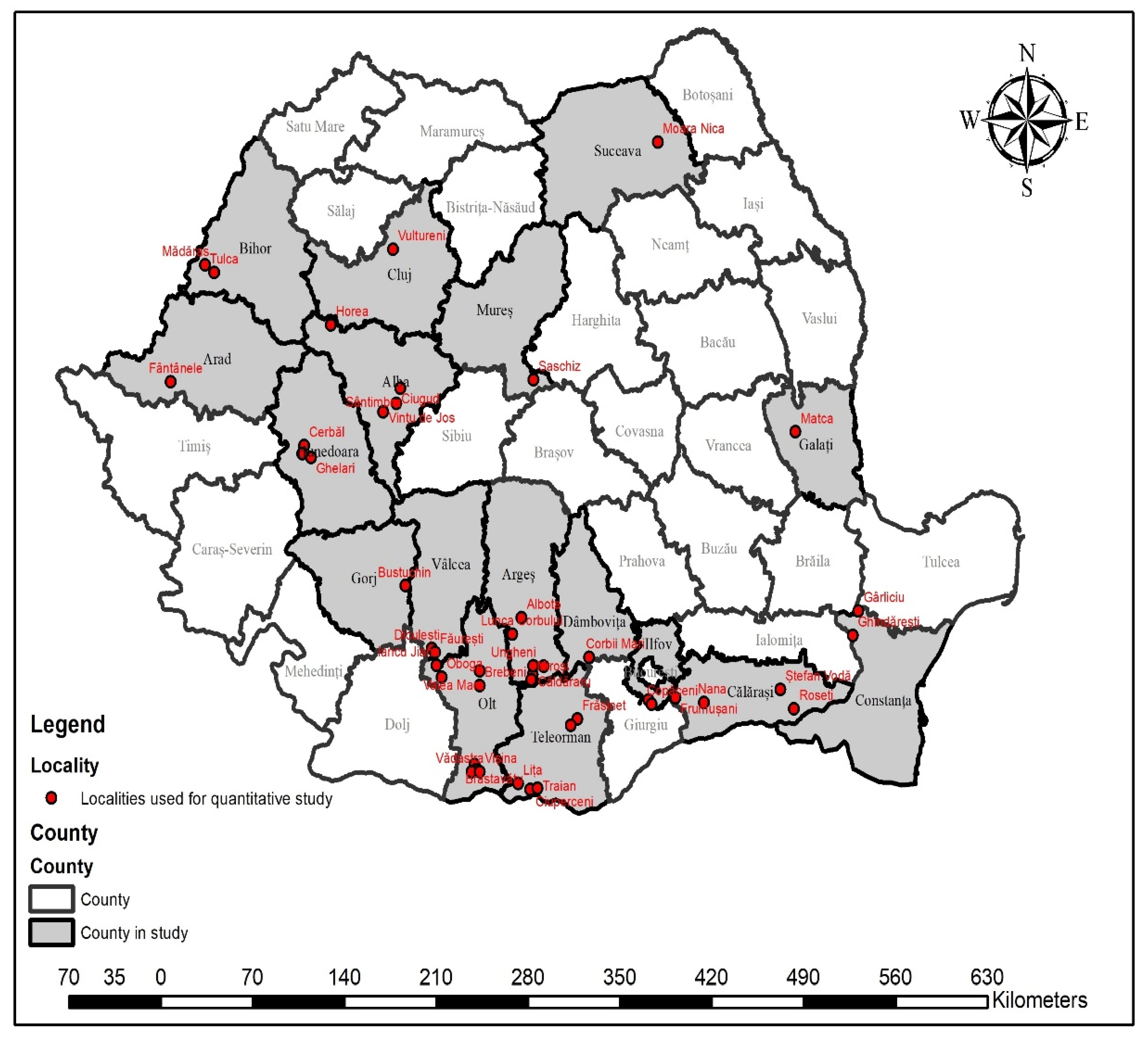
2. Materials and Methods

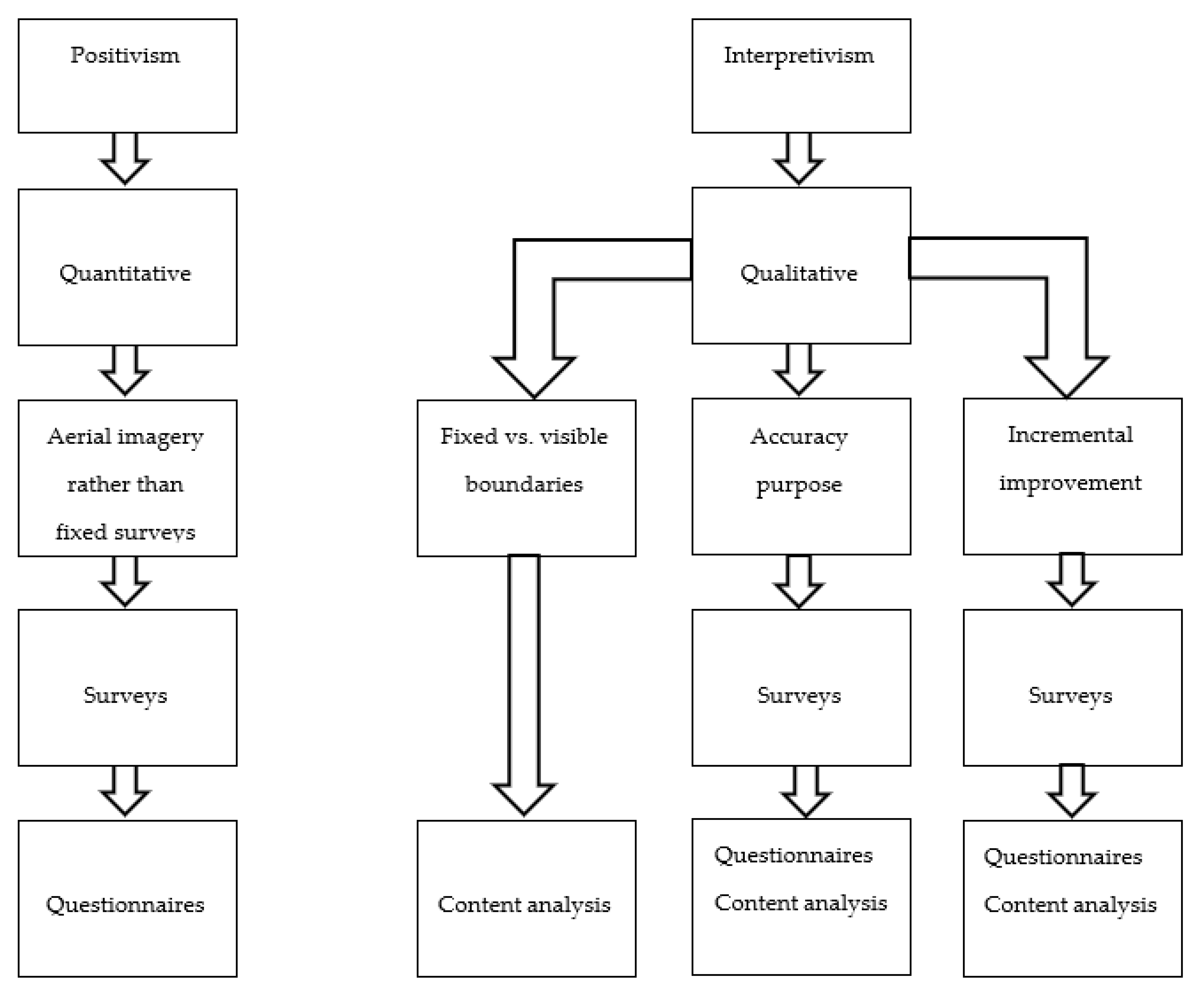
2.1. Research Paradigm

There are two paradigms that researchers use to make sense of the world. The positivist approach sees the reality as being objective and measurable with relations of cause and effect between phenomena [79,80,81]. On the other hand, the interpretivist paradigm sees reality as being a mental construct that is internal to the individual with reality being subjective–objective [82]. However, these two paradigms do not have to be viewed as parallel, but mostly as two ends of a continuum [83], with the researcher choosing methodologies and methods that can belong to any of them in order to make sense of reality.

2.2. Methodologies and Methods

This research will combine methods and methodologies from both paradigms of research. The principle of using aerial pictures rather than field surveys will be treated in a positivist approach using quantitative methods. The other principles will be studied in an interpretivist manner using qualitative methodologies.
The methodologies belonging to the two approaches will be used in a concurrent way, being employed in order to suit the principles under evaluation to gain an effective analysis [84]. The structure of the research can be seen in Figure 1.

2.2.1. Surveys

Through surveys, wide data are gathered at one point in time in order to analyze specific phenomena [85,86]. Interviews and questionnaires, structured or unstructured, are the most used methods for conducting surveys. Usually, surveys are used in quantitative studies and are based on samples chosen according to probabilistic principles [87,88]. However, surveys can also be used in an interpretivist paradigm because they can bring important insights into phenomena without the purpose of generalizing the results [88].
The present research uses three surveys for both qualitative and quantitative approaches. One survey was conducted in the positivism paradigm for the principle of aerial pictures rather than field surveys, while the other two were conducted in the interpretivist paradigm for the principles of accuracy linked to purpose rather than technical standards and incremental improvement.
Sampling is the main issue when conducting quantitative surveys. Considering the total number of the population there are several ways for calculating samples. Studies conducted by Krejcie and Morgan, Israel, and Taherdoost suggest using certain confidence intervals and margins of error in regard to the population considered [89,90,91]. However, Clegg affirms that selection of the sample has to be adapted to the type of research and the traditions in the field of research [92].
To study the principle of aerial images rather than field surveys, a sample of 45 localities was considered (administrative units) (Figure 2).
Almost all providers of work in The Romanian National Program of Systematic Land Registration authorities were asked to provide data for their completed localities. However, responses came for 45 localities (Table 1). They represent 35.16% of the total localities that were completed by June 2022. The confidence interval for the sample used was set at 85% with a margin of error of 8.78% (Table 2). The localities in the research were included irrespective of their area or other conditions.
As mentioned, surveys were also conducted to analyze the principles of accuracy linked to purpose rather than technical standards and incremental improvement, this time in an interpretivist paradigm. A panel of six managers from six different companies that execute land registration projects was used. The statistical attributes are not applied for surveys in the interpretivist approach (Table 2 and Table 3).
The managers included in the study have been chosen because their companies employed, between them, almost 50% of the localities completed in Romania, making them the biggest provider of this type of work in Romania. Three of them are companies considered to be of middle size, according to Romanian law (there are no big size companies in this field in Romania). The other three are small companies having under 50 employees. By choosing these two types of providers, the research aimed to include the views of managers of both middle and small size companies.

2.2.2. Questionnaires

Questionnaires are widely used when employing quantitative research, in order to assess experience or to be able to analyze links between variables [93]. For assessing the principle regarding the use of aerial images rather than field measurements, a questionnaire composed of four questions was designed (Table 4, Table 5 and Table 6). The first question was a closed question. The next three questions were multiple choice questions.
For assessing the principles of accuracy linked to purpose rather than technical standards and incremental improvement a questionnaire composed of multiple-choice questions was used. These questionnaires were sent to the respondents via email. All of the people selected for the panel responded to the questions.
The questionnaires were submitted to the managers by email. A short description of the study and its motivations was done by phone. They were asked to answer the questions according to the experience that their company had in the projects that they completed for the principle of aerial imagery rather than field surveys and according to their opinions for the principles of accuracy linked to purpose rather than technical standards and incremental improvement.
The results to questionnaires belonging to both approaches, quantitative and qualitative, are presented in the form of tables.

2.2.3. Content Analysis

With the help of content analysis, verbal, visual, and written communication can be analyzed [94]. Thus, it is a method that offers flexibility by using multiple approaches when analyzing texts [95,96]. On the other hand, critics see this method as just counting the number of occurrences of certain words [97,98]. However, content analysis goes beyond this purpose. The approach aims to “provide knowledge and understanding of the phenomena under study” [99] and concentrates on the context and the meaning of texts [100,101].
Context analysis uses a process called coding to manage the amount of data and to make sense of it. For Saldana (2013), a code is “a word or a short phrase that symbolically assigns a summative, salient essence-capturing and/or evocative attribute for a portion of language based or visual data”.
In this study, content analysis was employed in order to study the Technical Specifications for Systematic Land Registration issued by ANCPI in the year 2020. The previsions related to boundaries, aerial images, accuracy and improvement were put under scrutiny. References to these elements were extracted from the text and analyzed.
For the principle of accuracy linked to purpose rather than technical standards, coding was used to analyze a sample of rejection papers issued by local cadastral offices (OCPI), following submission of the work by private companies in 11 localities (Table 7).
A rejection paper is a document issued by OCPI in which the institution explains, for every parcel, the error that was discovered during the verification process. Parcels that have no errors are admitted. Parcels that have errors are rejected and transmitted to the provider in order to be corrected. The errors in the rejection papers were split into two types and coded (Table 3). The first category concerns geometric errors and refer to spatial data inaccuracies. The second category consists of textual data errors. These were judged to be failures to register different rights that belonged to people regarding ownership, usage or mortgages. These are the so called “material errors”, widely encountered in accounting or law practice. An example of the coding procedure can be found in Appendix A.

2.2.4. Limitations

Both paradigms of research, positivism and constructivism, and the methodologies and methods associated with them, have their own limitations. Positivism comes from the Western scientific tradition in which reality is objective and quantifiable. However, in reality, not everything is black or white and not every time variables are connected in a cause-effect kind of relationship. Objectivity and subjectivity are socially constructed and the split between them is artificially constructed. Knowledge cannot be separated from personal experience [102]. Quantitative data cannot include many of the characteristics of the population studied in this research. With the inclusion of different attributes, the results of the research may be different.
In a quantitative study, the confidence interval and the margin of error are dependent on the sample used and the practices in the field of research. The results of the study for the principle of aerial images rather than field surveys, are constrained by the confidence interval used. A higher sample can offer a higher confidence interval and a lower margin of error, leading to more reliable results.
Interpretivism bases the research paradigm on the background and experiences of the participants. The reality is socially constructed by the participant’s perceptions of the situation that is being analyzed [103]. However, researchers, such as Liu and Matthews, argue that interpretivism lacks epistemological substance as “where exists no absolute truth, any truth is as good as the other” [104]. Moreover, the results obtained from interpretivist research cannot be generalized, the findings being with low reliability, but with high validity [88]. The results obtained in this study by means of constructivist methods and methodologies cannot be expanded to other situations. Their validity is confined to the findings for the particular issue studied.
For the principle of accuracy linked to purpose rather than technical standards, the localities chosen to study inaccuracies were completed by two companies. Some of the errors may be caused by inappropriate methods or workflows that the companies employ.
The results obtained by means of surveys are limited by the fact that some respondents may be reluctant to answer the questions. The people selected for the study are top managers in their companies. Some of them might have been inclined to provide certain answers not to put their company in a disadvantageous position. This risk is reduced by not mentioning any company name in this article. Moreover, the managers of these companies have a background in geodesy and extended experience in working in cadaster projects. Their background may influence their choice of methods and opinions regarding the methods used in the projects studied. They may be more inclined to use classical methods of surveying and photogrammetry, instead of more modern approaches.
Content analysis was employed to analyze in which way the technical specifications issued by ANCPI relates to the principles of the spatial framework of the fit for purpose approach. The technical specifications analyzed are the ones used in the public procurement tender initiated by ANCPI in June 2020. However, localities considered in this study have been completed in the last ten years. In this period there were technical specifications issued for tenders. These specifications have suffered changes form one year to the other. It may be possible that certain previsions from the technical specifications from 2020 do not apply to localities executed in the past. However, the modifications were not significant and mostly do not affect the issues treated in this paper.
For content analysis, words and expressions were chosen to reduce the size of the text and make sense of it through a coding process [105]. However, interpretation of the meaning of texts can be subjected to factors that influence the researcher: like background of the researcher, cultural bias or even language understanding. This is an inherent risk of content analysis that researchers and readers have to be aware of.

3. Results

3.1. Visible (Physical) Boundaries Rather Than Fixed Boundaries

The Romanian registration system puts much more emphasis on surfaces than on property limits. The cause is that the majority of the people already have their titles issued with surfaces inscribed on it. However, most of the land was not measured, and the titles were issued on old, outdated maps.
The technical specifications do not make any clear distinction between fixed and general boundaries. Instead of the term boundary, the technical specifications use the term “property limit” [12,13]. The owner has to indicate the characteristic points of the property limit to a surveyor that measures them. If the surface measured exceeds the one inscribed in the property title, in certain conditions, the remaining surface may be assigned to the owner as “possession”. However, it does not matter if the boundary is visible or not. If the property is already registered, by means of sporadic registration, the surface must not be modified, but the position or shape of the parcel may be changed.
There is one instance that can be assimilated with the fit for purpose principle of visible boundaries. “Visible and clearly identifiable” elements like fences, constructions or roads, can constitute “property limits” [13]. In this case, the surface inscribed is the surface in between the “visible boundaries”, even if it is higher or lower than the one inscribed on property titles.
In a system that emphasizes reconstruction of surfaces instead of reconstruction of boundaries, many delays can occur. Lack of sufficient land in certain situations, lead to surface reduction for parcels. This creates unhappiness among people that issue complaints or address the issue to the judiciary system. All these actions cause delays in implementing land registration. On the other hand, Romania is one of the countries that has the most trials at the European Court of Human Rights, with 97% of decisions linked to ownership rights [106]. People are inclined to go to court even for small surfaces that are missing. A fit for purpose approach that emphasizes physical boundaries can be more appropriate in intra-urban areas, where these boundaries are established for a long time, than in extra-urban areas.

3.2. Aerial Imagery Rather Than Field Surveys

The Technical Specifications issued by ANCPI allow the use of orthophotos, for scales 1:2000 or higher, only as a support for field measurements for parcels that have “visible boundaries” in intra-urban areas [13]. In all other cases, field measurements are mandatory for intra-urban areas. The technical specifications do not make references to the use of orthophotos for extra-urban areas. However, they specify that “when parcel plans are missing”, the identification can be done with the help of the “data collected from OCPI” [13]. These data include existent orthophotos, so it can be affirmed that orthophotos can be used for identification of parcels in extra-urban areas.
The fit for purpose approach recommends the use of satellite images or UAV’s. In the Romanian practice, for intra-urban areas, images are used only as support for field measurements, not necessarily replacing or reducing them, so this practice cannot be considered consistent with the fit for purpose approach. In extra-urban areas, the use of orthophotos is not explicitly forbidden or recommended. The provider of the work can choose to use orthophotos if it considers it appropriate. This approach can be considered as consistent with the fit for purpose principle of aerial images rather than field surveys.
To assess the use of aerial images in practice, a study on 45 localities was conducted as mentioned in Table 1. For 91% of all localities involved in the study, aerial images were used.
There are many ways to obtain aerial images, e.g., from classical methods using helicopters and planes, to the use of UAV’s or satellite images. For the localities studied, satellite images were not used. Aerial images collected with classical methods like planes and helicopters was used in 40% of the localities. The collection of aerial images with modern methods like UAVs was performed for one third of the localities, while in 18% of the localities, old orthophotos were used (Table 4).
Using planes and helicopters to collect images is expensive. The fit for purpose approach recommends more modern and economical solutions like UAV’s and satellite images. In the Romanian National Program of Systematic Land Registration, aerial images are used on a large scale. However, only in a third of the localities studied were aerial images obtained using UAVs and none were obtained using satellite images. It can be affirmed that there are similarities with the fit for purpose recommendations of using aerial images, but not with the recommendation that these images should be obtained through inexpensive methods like UAV’s and satellites.
In a fit for purpose approach, images are used to help determine land boundaries. The process is often participative with the community engaging in identification of parcel limits. The systematic land registration in Romanian does not exclude the use of aerial images. The technical specifications require the owners to be present and help in the identification of boundaries. If they are not present, a city hall representative must be present [13]. This prevision postulates the participative nature of the process in accordance with the fit for purpose concept.
In practice, in all localities surveyed for this study, the process of registering the properties was participative. In over 70% of the cases, the identification of boundaries was done with the help of orthophotos, but there were also measurements conducted in the field in the presence of the owners. In 22% of the localities surveyed, field measurements were used in the presence of the owners, without using orthophotos. That does not mean that orthophotos were not used at all, as they could have been used as support for drawing the cadastral plans. For 2% of the localities, representing in fact one locality, only orthophotos, with the participation of the owners, were used for boundary identification (Table 5). The survey shows that the community was involved in all the localities studied.
The last question, regarding the principle of aerial images rather than field surveys, was designed to assess the accuracy of the images used in relation with the field measurements used. In 65% of the localities studied, the aerial images ensured the required accuracy with only a small amount of field measurements being needed to establish boundaries. For 22% of the localities, the accuracy of the images was not sufficient, so there was a need to complement them with a large number of measurements in the field, while in 13% of the localities, the images only ensured in part the required accuracy. Here, a number of field surveys was also necessary to complement the images (Table 6).
The fit for purpose concept states that aerial images should be used rather than field surveys. This does not mean that field surveys should not be employed, but they should be used in accordance with the purpose of the project. In the Romanian practice, field surveys were used for all the localities studied. However, the use of aerial images reduced the need for field measurements in two thirds of the localities in the study. It can be affirmed that the Romanian practice has similarities with the principle of using aerial images rather than field surveys.
The managers in the Romanian companies studied are reluctant to renounce the use of extensive field measurements. The owners of the companies are trained and certified land surveyors, making them prone to preferring more classical methods of data gathering. The extensive use of field measurements is expensive and time consuming. On the other hand, a fit for purpose approach would increase the speed of registration by using field measurements where is necessary and extensive aerial images. However, it must be taken into account that the precision requirements for the Romanian land registration system are high. Moreover, other stakeholders involved, e.g., mayors, OCPI employees, and citizens, trust classical land surveying methods.

3.3. Accuracy Linked to Purpose Rather Than Technical Standards

The required precision set by the technical specifications for boundary determination is “according to the precision of the cadastral plan scale 1:5000 for extra-urban areas and 1:2000 for intra-urban areas” [12,13]. Expressed in measurement units, it translates into 1 m for extra-urban areas and 40 cm for intra-urban areas. On the other hand, besides spatial data there is textual data. This consists of data that are introduced in the database from property titles, identification papers, and other documents.
The verification process is done by OCPI, and the rules are stated in the technical specifications. There is a quantitative verification and, after that, there is the qualitative verification. There are no previsions regrading what accuracy means for textual data. It can be affirmed that error can mean any type of inaccuracy. Therefore, textual data have to be 100% accurate. The technical specifications state that if more than 20% of the parcels verified contain errors, than the delivery must be resubmitted [13].
A sample of errors taken from rejection papers of 11 localities was analyzed in order to determine what type of inaccuracies have the most occurrences.
The sample of errors taken from the rejection papers (Table 7) show that the highest number of errors are caused by inaccuracies in the textual data, over 87%. These data are usually taken from different sources, ownership titles, ID, or other documents and introduced by operators into the data base. The localities analyzed show that there are fewer occurrences for errors concerning spatial data accuracy, i.e., 12.1%. So, where accuracy has to be 100%, and any small detail that is not right may be considered an error, the number of errors becomes very high. On the other hand, the prevalence of geometric errors is far less. When there is margin for error, the number of inaccuracies is far less than in the case of textual data where there is no margin for error.
Table 7. Localities in which number of errors were counted from the rejection papers.
No.LocalityGeometric Accuracy ErrorsPercentage of Total ErrorsTextual Data Accuracy ErrorsPercentage of Total ErrorsTotal Errors
1Vultureni19110.3166289.71853
2Ciugud704.6145395.41523
3Lelese349.532390.5357
4Ghelari3410.728389.3317
5Cerbal124.923395.1245
6Saschiz3816.119883.9236
7Madaras5452.94847.1102
8Moara1516798494
9Batar5463.63136.485
10Izvoru1825.35374.771
11Matca1136.61963.430
Total53112.1438287.94913
Concerning spatial data, the panel selected for this study was required to state their opinion about the accuracy requirements in the technical specifications. Out of the six managers questioned, four are of the opinion that the requirements for spatial data accuracy are appropriate, while two of them consider that the requirements for accuracy are too high (Table 8).
The same answers were registered for the accuracy of textual data with four people stating that the accuracy requirements are appropriate and two being of the opinion that the accuracy is too high (Table 8).
The fit for purpose concept proposes a flexible approach to accuracy, with different requirements depending on the purpose of the project. The technical specifications provide for different accuracies in regard to geometric accuracy for spatial data in intra-urban and extra-urban areas. On the other hand, accuracy for textual data has to be 100%, therefore it is not differentiated by anything. However, in practice, the panel considered for this study sees the requirements as appropriate for the purpose of the project.
There seems to be a contradiction between the high number of errors, especially for textual data, and the opinion of the managers that the requirements for accuracy is appropriate at this moment. However, it must be noted that data gathering for land registration projects in Romania is done by certified land surveyors. To become certified, one of the conditions is to have a training in land surveying. The managers interviewed here have their training in land surveying, making them more inclined to accept high standards of accuracy.
The high standards for accuracy are one of the most common causes for bottlenecks in the Romanian land registration system. High accuracy in spatial and textual data leads to high rates of mistakes. Correcting these mistakes takes time and the whole process is delayed. An approach that is flexible in terms of accuracy, will lead to a smaller number of errors, decreasing the rate of work rejection. A fit for purpose approach will speed up the process significantly. However, other stakeholders, e.g., OCPI employees, mayors, or citizens, may be reluctant to an approach that allows flexible standards for accuracy.

3.4. Incremental Improvement

The technical specification for systematic registration works does not specify anything about what happens after the completion of the works in a locality. However, in the contracts for each locality, it is a period of one year in which eventual complaints by the citizens have to be resolved. There is no dedicated procedure for modifying or correcting the parcels registered through The National Program of Systematic Land Registration. To modify and improve the accuracy of spatial and textual data of the parcels registered, the rules of the sporadic registration apply.
The same panel of six top managers in companies that conducted systematic registration projects was used to find out if the parcels registered can be incrementally improved with ease. None of them is of the opinion that the parcels can be easily modified, while five are of the opinion that the parcels are very hard to modify and that the procedures to do that are complicated and unclear (Table 8).
The fit for purpose approach states that once the system is in place, it has to be kept up to date and improved over time, incrementally. The Romanian land registration system allows for incremental improvements. However, there are no guidelines on how these improvements should take place. There is no specially designed procedure. The procedures that apply are those belonging to sporadic registration, which are not clear and simple. It may be affirmed that the principle of incremental improvement exists, although it is very difficult to apply.

4. Discussion

4.1. Main Findings

For the principle of using visible (physical) boundaries rather than fixed boundaries, this research shows that in The Romanian National Program of Systematic Land Registration much more emphasis is put on parcel surfaces than on visible boundaries. However, there is an instance in which visible boundaries can be used, but they also have to be fixed. The Romanian National Program of Systematic Land Registration practice is not consistent with the principle of the spatial framework of the fit for purpose approach of using visible (physical) boundaries rather than fixed boundaries (Table 9).
For the principle of the use of aerial images on a large scale rather than field surveys, this research found that in The Romanian National Program of Systematic Land Registration aerial images are used on a large scale. On the other hand, they do not replace field measurements, but mostly complement them. Most of the localities analyzed in this paper benefited from aerial images collected by classic means instead of modern inexpensive technologies.
In regards to the participative nature of the process, the Technical Specifications for The Romanian National Program of Systematic Land Registration require a participative approach. The people must participate in the identification of boundaries, have to deliver ownership documents, have to verify the work and have the possibility to issue complaints if they do not agree with any of the aspects that are registered. The process is fully participative. The Romanian practice shows that there are similarities with the spatial framework of the fit for purpose principle of using aerial images rather than field surveys (Table 9).
For the principle of accuracy linked to purpose for the localities analyzed in this research, most of the accuracy errors come from textual data. On the other hand, the answers of the panel considered for this study show that requirements for textual and geometric data are appropriate for the purpose of the project. While there are different accuracy requirements for geometric data, the textual data have to be 100% accurate. The Romanian practice of The Romanian National Program of Systematic Land Registration has similarities with the spatial framework of the fit for purpose principle of accuracy linked to purpose rather than technical standards for spatial accuracy, but it is in contradiction concerning textual accuracy (Table 9).
For the principle of incremental improvement, in The Romanian National Program of Systematic Land Registration, there is a period of maintenance written in the contract for every project. However, this is almost impossible as there are no previsions on how the update and modification of the data should be performed. The ways in which these procedures are set is not consistent with the prevision of the fit for purpose principle of incremental improvement (Table 9).

4.2. Similarities with Other Studies

Similar findings can be found in studies that have analyzed the realities of certain countries against the fit for purpose approach. Significant delays have been encountered in Mozambique, where the registration of five million parcels is not going as planned. Here, too, the legislation contains previsions similar with the fit for purpose approach: appropriate requirements for spatial accuracy or participatory approach. However, as in Romania, there are no methodologies for updating the system [62].
In analyzing the situation of similar programs in Ghana and Kenya, [107] show that all the principles of the fit for purpose spatial framework are valid. On the other hand, in Namibia, the principle of physical boundaries is not used, while in Ecuador the principles regarding boundaries, aerial images and accuracy have a low conformity with the fit for purpose concept [26]. These studies use scores from “low conformity to high conformity” in Ecuador and from “adopted, moderately adopted or not adopted” for Ghana, Kenya, and Namibia. However, the use of scales was not considered appropriate for this study. While scales can provide a general picture of a phenomena, they cannot comprise the nuances and particularities of each principle or situation.

4.3. Implication and Explanation of the Study

There is a lack of knowledge that policy makers in the Romanian land administration system have in regards to the fit for purpose land administration concept. There is no literature that links the fit for purpose concept with the Romanian land registration national program. This needs to be changed. The present research puts into discussion the current practices of The Romanian National Program of Systematic Land Registration by looking at them from the perspective of the fit for purpose principles of the spatial framework. These findings can serve the current Romanian policy makers to:
  • Familiarize themselves with the theoretical background of the fit for purpose land administration principles regarding the spatial framework;
  • Acknowledge the differences between the practices of The Romanian National Program of Systematic Land Registration and the fit for purpose approach regarding the spatial framework;
  • Analyze if the fit for purpose approach can be useful in speeding up land registration in The Romanian National Program of Systematic Land Registration;
  • To take action for implementing an approach to The Romanian National Program of Systematic Land Registration that is flexible, concentrated on purpose and can speed up the process of registration.
The findings of this research will complement the existing literature regarding the evaluation of different programs of land registration. Similarities with the practices of The Romanian National Program of Systematic Land Registration can be found in other countries in which such programs are implemented and the lessons learned here can constitute basis for future research.

4.4. Strengths and Limitations

This study uses mixed methods to analyze the data. The advantage of this approach is that it can work both with quantitative and qualitative sets of data. The component of this study that uses quantitative data has the advantage that it has high reliability, while the component of this study that uses qualitative data has high validity.
This study has its limitations besides the ones that are common to the research paradigms approached. The samples used for quantitative analysis of the data regarding the principle of aerial images rather than field surveys can be improved for further research. Findings from the quantitative analysis apply only to the cases specified in this research. They represent the opinions of the managers that participated in the survey and cannot be generalized.

5. Conclusions, Recommendations and Future Research

The Romanian National Program of Systematic Land Registration was not conceived as a fit for purpose approach. However, a move towards such a system seems necessary in order to speed up the registration process. High standards of accuracy without flexibility, the use of field measurements on a large scale, or lack of provisions for improvement and updating the system are bottlenecks that delay the process of land registration significantly. The spatial framework has to be redesigned, in order to be more flexible, focused on purpose and easy to improve.
One of the possibilities for The Romanian National Program of Systematic Land Registration to gain some speed would be to adopt some of the principles of the fit for purpose approach. A number of recommendations that are in the spirit of the fit for purpose approach can be analyzed, in order to improve the current way of systematic land registration in Romania:
  • Registering the land earlier in the process. The parcels should be registered as soon as possible, through a participative process, without verifications by OCPI. After the data gathering and processing, the documents should enter directly into the stage of public display. The period of the verification of work by OCPI can be simultaneous with that of public display. With input from both OCPI and owners at the same time, the company that executed the work can correct all the parcels. In this way, 2–6 months, the period in which the OCPI is verifying the work according to the current regulations and the private companies are correcting it, can be cut from the process.
  • Flexible requirements for accuracy. There are no clear definitions regarding what an inaccuracy means. Parcels can be rejected for a letter spelled wrong or for failure to register an owner. Small or big, every error is quantified and adds up to the number, causing rejections and time spent on correcting the errors. The process should be flexible, and the registration should not be stopped because of errors. In human activity, errors are produced all the time. One possibility is to divide the errors in accordance to their importance to the project. The errors that have an immediate effect on ownership, e.g., failure to register a parcel, should be corrected immediately. Small errors, e.g., a name spelled wrong or geometric errors, should be treated differently and corrected during or after the process. A warranty period of 2–3 years can be introduced for these small errors to be corrected.
  • Flexibility on technical standards. Many stakeholders in the land registration projects are reluctant to give up on rigid technical requirements. OCPI employees, mayors, Certified surveyors, even citizens are suspicious of new land surveying methods. Numerous references to classical land measurement methods are done in the rules of regulations of The Romanian National Program of Systematic Land Registration. These technical standards impede creativity and the use of new technologies. The rules and regulations should be revised. They should only specify what the end result should be, not the technical methods to be used.
  • Regulations for incrementally improvement of the system. The mistakes that are find after the completion of the works are very hard to correct. New regulations that can allow the easy modification of the works must be implemented. A fit for purpose approach that recommends the incrementally improvement of parcels in time will give assurance to the owners and cadastral offices employees. If the system is easy to modify, the employees will be more inclined not to take any trivial inaccuracy into consideration and will feel more comfortable in approving the work. The regulations have to provide for administrative measures, not to agglomerate the courts with trials for trivial mistakes. Moreover, the modifications must be made as such so as not to create discomfort to the owners.
Further analysis is needed in order to complement the findings of this study. The spatial component of The Romanian National Program of Systematic Land Registration represents only one aspect of the project. To be able to have a more complete overview of the subject, future analysis has to concentrate on the legal and institutional aspects of the project.

Author Contributions

Conceptualization, V.P. and D.K.; methodology, V.P.; software, M.-E.N. and E.-E.Ș.; validation, V.P. and T.S.; formal analysis, A.-I.I. and E.-E.Ș.; investigation, D.K. and M.-E.N.; resources, A.-I.I. and M.-E.N.; data curation, A.-I.I. and E.-E.Ș.; writing—original draft preparation, V.P. and E.-E.Ș.; writing—review and editing, T.S.; visualization, D.K. and E.-E.Ș.; supervision, T.S.; project administration, V.P. and T.S.; funding acquisition, V.P. All authors have read and agreed to the published version of the manuscript.

Funding

This research received no external funding.

Institutional Review Board Statement

Not applicable.

Informed Consent Statement

Not applicable.

Data Availability Statement

Not applicable.

Conflicts of Interest

The authors declare no conflict of interest.

Appendix A

Table A1. Example of the coding procedure.
LocalityErrorCode
Saschiz“A parcel that contains construction must be in the intra-urban area”Textual data
Izvoru“Topology error”Geometric
Moara“Wrong deed number”Textual data
Matca“Wrong plot number”Textual data
Cerbal“Wrong identification with the Austrian landbook”Textual data
Ghelari“Surface differences between property title and what is being registered”Geometric

References

  1. Desa, U.N. Transforming our World: The 2030 Agenda for Sustainable Development, A/RES/70/1; United Nations: New York, NY, USA, 2016. [Google Scholar]
  2. Enemark, S. Building Land Information Policies. Proc. Spec. Forum Build. Land Inf. Policies Americas. Aguascalientes Mex. 2004, 26, 2004. [Google Scholar]
  3. Williamson, I.; Enemark, S.; Wallace, J.; Rajabifard, A. Land Administration for Sustainable Development; ESRI Press Academic: Redlands, CA, USA, 2010. [Google Scholar]
  4. Ece, U. Land Administration Guidelines with Special Reference to Countries in Transition; Geneva, United Nations, Economic Commission for Europe: Geneva, Switzerland, 1996. [Google Scholar]
  5. Burns, T.; Grant, C.; Nettle, K.; Brits, A.M.; Dalrymple, K. Land Administration Reform: Indicators of Success. Agric. Rural. Dev. Discuss. Pap. 2007, 37, 1–227. [Google Scholar]
  6. Burns, T. International Experience with Land Administration Projects: A Framework for Monitoring of Pilots; National Workshop on Land Policies and Administration for Accelerated Growth and Poverty Reduction: New Delhi, India, 2006. [Google Scholar]
  7. Bandeira, P.; Sumpsi, J.M.; Falconi, C. Evaluating Land Administration Systems: A Comparative Method with an Application to Peru and Honduras. Land Use Policy 2010, 27, 351–363. [Google Scholar] [CrossRef]
  8. Barthel, K.; Stanfield, J.D.; Barnes, G. Land Registration Modernization in Developing Economies: A Discussion of the Main Problems in Central/Eastern Europe, Latin America and the Caribbean. In URISA Conference; Urisa: Des Plaines, IL, USA, 1999. [Google Scholar]
  9. Verdery, K. Seeing Like a Mayor: Or how Local Officials Obstructed Romanian Land Restitution. Ethnography 2002, 3, 5–33. [Google Scholar] [CrossRef]
  10. Petrescu, D.; Petrescu-Mag, R.; Surd, V. Romania’s Agriculture: Trends and Challenges. AAB Bioflux 2010, 2, 151–174. [Google Scholar]
  11. Legea 7/1996 a Cadastrului si Publicitatii Imobiliare, Monitorul Oficial: Bucuresti, Romania, 2017.
  12. ANCPI. Ordinul nr. 700 Privind Aprobarea Regulamentului de Avizare, Receptie si Inscriere in Evidentele de Cadastru si Carte Funciara; ANCPI: Bucuresti, Romania, 2014. [Google Scholar]
  13. ANCPI. Technical Specifications for Carrying Out Systematic Cadastre Works; no. 1/07.01.2020; ANCPI: Bucharest, Romania, 2020. [Google Scholar]
  14. Badea, A.C.; Badea, G.; David, V. A Study About New Cadastral Legislative Provisions in Romania Correlated with Cadastre 2034. In Proceedings of the 15th International Multidisciplinary Scientific Geoconference SGEM, Albena, Bulgaria, 18–24 June 2015. [Google Scholar]
  15. Badescu, G.; Calina, A.; Calina, J.; Milut, M.; Babuca, N.; Croitoru, A.; Buzatu, C. Some Aspects Regarding the Use of GNSS Technology in The General Cadastre Works in Romania. Ann. Univ. Craiova-Agric. Mont. Cadastre Ser. 2018, 47, 465–469. [Google Scholar]
  16. Gresita, I.C.; Grigorie, T.L. Systematic Cadastre for Agricultural Land in Romania. Int. Multidiscip. Sci. GeoConference SGEM 2017, 17, 673–678. [Google Scholar]
  17. Oprea, L. The Registration of Real Estate Through Systematic Cadastre. Int. Multidiscip. Sci. GeoConference SGEM 2017, 17, 681–688. [Google Scholar]
  18. Koncsag, M.E.; Velţan, V. Implementation of Systematic Cadastre in Sector 60 of the Valea Largă Commune, Mureş County, Romania. Pangeea 2019, 19, 105–113. [Google Scholar]
  19. Pop, N.; Pop, S.; Milut, M. Realization of the Topo-Cadastral Works Necessary for the Registration of a Cadastral Sector, Belonging to Cătina Commune, Cluj County in Systematic Cadastre. Ann. Univ. Craiova-Agric. Mont. Cadastre Ser. 2021, 50, 468–474. [Google Scholar]
  20. Potsiou, C.; Paunescu, C.; Ioannidis, C.; Apostolopoulos, K.; Nache, F. Reliable 2D Crowdsourced Cadastral Surveys: Case Studies from Greece and Romania. ISPRS Int. J. Geo-Inf. 2020, 9, 89. [Google Scholar] [CrossRef]
  21. Savoiu, C.; Lemmen, C.; Saviou, I. Systematic Registration in Romania a New Opportunity for Land Consolidation. In FIG Working Week; FIG Publishing Inc.: Sofia, Bulgaria, 2015. [Google Scholar]
  22. Bennett, R.M.; Alemie, B.K. Fit-for-purpose land administration: Lessons from urban and rural Ethiopia. Surv. Rev. 2016, 48, 11–20. [Google Scholar] [CrossRef]
  23. Zevenbergen, J.; De Vries, W.; Bennett, R.M. Advances in Responsible Land Administration; CRC Press: Boca Raton, FL, USA, 2015. [Google Scholar]
  24. Enemark, S.; McLaren, R.; Lemmen, C. Fit-For-Purpose Land Administration Guiding Principles; Global Land Tool Network (GLTN): Copenhagen, Denmark, 2015. [Google Scholar]
  25. Enemark, S.; McLaren, R.; Lemmen, C. Fit-for-Purpose Land Administration-Providing Secure Land Rights at Scale. Land 2021, 10, 972. [Google Scholar] [CrossRef]
  26. Todorovski, D.; Salazar, R.; Jacome, G. Assessment of Land Administration in Ecuador Based on the Fit-for-Purpose Approach. Land 2021, 10, 862. [Google Scholar] [CrossRef]
  27. Milindi Rugema, D.; Birhanu, T.A.; Shibeshi, G.B. Spatial Aspect of Fit-For-Purpose Land Administration for Emerging Land Administration Systems: A Conceptual Framework for Evaluation Approach. Surv. Rev. 2022, 54, 79–92. [Google Scholar] [CrossRef]
  28. Dawidowicz, A.; Zysk, E.; Źróbek, R. A Methodological Evaluation of the Polish Land Administration System Using the Fit-For-Purpose Approach. Geomat. Environ. Eng. 2020, 14, 31–47. [Google Scholar] [CrossRef]
  29. Larsson, G. Land Registration and Cadastral Systems; Tools for Land Information and Management; Longman Scientific and Technical: London, UK, 1991. [Google Scholar]
  30. Simpson, S.R. Land Law and Registration; Cambridge University Press: Cambridge, UK, 1976. [Google Scholar]
  31. Deininger, K.; Feder, G. Land Registration, Governance, And Development: Evidence and Implications for Policy. World Bank Res. Obs. 2009, 24, 233–266. [Google Scholar] [CrossRef]
  32. Ali, D.A.; Deininger, K.M.G.; Duponchel, M. Sustaining the Success of the Systematic Land Tenure Registration in Rwanda; World Bank Group: Washington, DC, USA, 2016. [Google Scholar]
  33. Ali, D.A.; Deininger, K.M.G.; Nyakulama, R. Sustaining Land Registration Benefits by Addressing the Challenges of Reversion to Informality in Rwanda. Land Use Policy 2021, 110, 104317. [Google Scholar] [CrossRef]
  34. Feder, G.; Nishio, A. The Benefits of Land Registration and Titling: Economic and Social Perspectives. Land Use Policy 1998, 15, 25–43. [Google Scholar] [CrossRef]
  35. Place, F.; Migot-Adholla, S.E. The Economic Effects of Land Registration on Smallholder Farms in Kenya: Evidence from Nyeri and Kakamega Districts. Land Econ. 1998, 74, 360–373. [Google Scholar] [CrossRef]
  36. Singirankabo, U.; Ertsen, M. Relations between Land Tenure Security and Agricultural Productivity: Exploring the Effect of Land Registration. Land 2020, 9, 138. [Google Scholar] [CrossRef]
  37. Fhonna, T.A.; Mutiarin, D.; Saputra, H.A.; Latif, I.R. Implementation of the Complete Systematic Land Registration Program in Aceh, Indonesia. Otoritas J. Ilmu Pemerintah. 2021, 11, 108–124. [Google Scholar] [CrossRef]
  38. Septianingsih, S.R. Studi Tentang Pelayanan Penerbitan Sertifikat Tanah Di Kantor Pertanahan Kota Samarinda. Ejournal Ilmu 2015, 3, 265–278. [Google Scholar]
  39. Jimmy, F.B.; Frans, G.; Adang, D.A.S. Employee Performance in Implementing Complete Systematic Land Registration: A Study on the Office of Agrarian Affairs and Spatial Planning/National Land Agency of Kupang Regency, Indonesia. Forest 2019, 2, 288–397. [Google Scholar]
  40. Jansen, K.; Roquas, E. Modernizing Insecurity: The Land Titling Project in Honduras. Dev. Change 1998, 29, 81–106. [Google Scholar] [CrossRef]
  41. Mitchell, T. The Properties of Markets: Informal Housing and Capitalism’s Misery; Institute for Advanced Studies in Social and Management Sciences: Lancaster, PA, USA, 2006. [Google Scholar]
  42. Sikor, T. Politics of Rural Land Registration in Post-Socialist Societies: Contested Titling in Villages of Northwest Vietnam. Land Use Policy 2006, 23, 617–628. [Google Scholar] [CrossRef]
  43. Kobusingye, D.N.; van Leeuwen, M.; van Dijk, H. Where do I report my land dispute? The Impact of Institutional Proliferation on Land Governance in Post-Conflict Northern Uganda. J. Leg. Plur. Unoff. Law 2016, 48, 238–255. [Google Scholar] [CrossRef]
  44. Balas, M.; Murta, J.; Almeirim de Carvalho, J.; Joaquim, S.P.; Carrilho, J.; Lemmen, C. Assisted Community-Led Systematic Land Tenure Regularization. In Proceedings of the 2018 World Bank Conference on Land and Poverty—Land Governance in an Interconnected World, Washington, DC, USA, 19–23 March 2018. [Google Scholar]
  45. Van der Mollen, R. Changing Basic Concepts in Land Registry and Cadaster. In Proceedings of the International Symposium on GIS, McLean, VA, USA, 8–9 November 2002. [Google Scholar]
  46. Kuntu-Mensah, P. On The Implementation of Land Title Registration in Ghana. In Proceedings of the Promoting Land Administration and Good Governance 5th FIG Regional Conference, Accra, Ghana, 8–11 March 2006. [Google Scholar]
  47. Deininger, K.; Chamorro, J.S. Investment and equity effects of land regularization: The case of Nicaragua. Agric. Econ. 2004, 30, 101–116. [Google Scholar] [CrossRef]
  48. Zevenbergen, J.; Augustinus, C.; Antonio, D.; Bennett, R. Pro-Poor Land Administration: Principles for Recording the Land Rights of the Underrepresented. Land Use Policy 2013, 31, 595–604. [Google Scholar] [CrossRef]
  49. Enemark, S. Fit-for purpose Land Administration. GIM Int. 2013, 27, 26–29. [Google Scholar]
  50. Enemark, S.; Bell, K.C.; Lemmen, C.H.J.; McLaren, R. Fit-For-Purpose Land Administration; International Federation of Surveyors: Copenhagen, Denmark, 2014. [Google Scholar]
  51. Williamson, I.P. Land Administration “Best Practice” Providing the Infrastructure for Land Policy Implementation. Land Use Policy 2001, 18, 297–307. [Google Scholar] [CrossRef] [Green Version]
  52. De Soto, H. The Mystery of Capital: Why Capitalism Triumphs in the West and Fails Everywhere Else, 1st ed.; Civitas Books: New York, NY, USA, 2000. [Google Scholar]
  53. Măntescu, L.; Vasile, M. Property Reforms in Rural Romania and Community-Based Forests. Rom. Sociol. 2009, 7, 95–113. [Google Scholar]
  54. Oprea, L.; Ienciu, I.; Tudorașcu, M. Legal and Technical Effects of Property Law Application in Romania. In Proceedings of the 14th International Multidisciplinary Scientific GeoConference SGEM, Albena, Bulgaria, 17–26 June 2014. [Google Scholar]
  55. Stan, L. The Roof Over Our Heads: Property Restitution in Romania. J. Communist Stud. Transit. Politics 2006, 22, 180–205. [Google Scholar] [CrossRef]
  56. Wassie, Y.A.; Koeva, M.N.; Lemmen, C.H.J. A Procedure for Semi-Automated Cadastral Boundary Feature Extraction from High-Resolution Satellite Imagery. J. Spat. Sci. 2018, 63, 75–92. [Google Scholar] [CrossRef]
  57. Zevenbergen, J. Systems of Land Registration Aspects and Effects. Publ. Geod. 2002, 51, 3–24. [Google Scholar]
  58. Dale, P.F.; McLaughlin, J.D. Land Information Management, an Introduction with Special Reference to Cadastral Problems in Third World Countries; Clarendon Press: Oxford, UK, 1988. [Google Scholar]
  59. Luo, X.; Bennett, R.M.; Koeva, M.; Lemmen, C. Investigating Semi-Automated Cadastral Boundaries Extraction from Airborne Laser Scanned Data. Land 2017, 6, 60. [Google Scholar] [CrossRef]
  60. López, R. Land Titles and Farm Productivity in Honduras; AREC University of Maryland and World Bank: College Park, MD, USA, 1996. [Google Scholar]
  61. Jacoby, H.G.; Minten, B. Is Land Titling in Sub-Saharan Africa Cost-Effective? Evidence from Madagascar. World Bank Econ. Rev. 2007, 21, 461–485. [Google Scholar] [CrossRef]
  62. Balas, M.; Carrilho, J.; Joaquim, S.; Murta, J.; Lemmen, C.; Matlava, L.; Marques, M.R. Mozambique Participatory Fit for Purpose Massive Land Registration. In Proceedings of the Annual World Bank Conference on Land and Poverty, Washington, DC, USA, 20–24 March 2017. [Google Scholar]
  63. Bezu, S.; Holden, S. Demand for Second-Stage Land Certification in Ethiopia: Evidence from Household Panel Data. Land Use Policy 2014, 70, 193–205. [Google Scholar] [CrossRef]
  64. Lipej, B.; Male, J. Participatory Mapping in Support of Improved Land Administration and Management of Natural Resources. Surv. Rev. 2015, 47, 342–348. [Google Scholar] [CrossRef]
  65. Morales, J.; Lemmen, C.; de By, R.; Molendijk, M.; Oosterbroek, E.P.; Ortiz Davila, A.E. On The Design of a Modern and Generic Approach to Land Registration: The Colombia Experience. In Proceedings of the 8th Land Administration Domain Workshop, Kuala Lumpur, Malaysia, 1–3 October 2019; pp. 1–3. [Google Scholar]
  66. Balas, M.; Carrilho, J.; Lemmen, C. The Fit for Purpose Land Administration Approach-Connecting People, Processes and Technology in Mozambique. Land 2021, 10, 818. [Google Scholar] [CrossRef]
  67. Rijke, J.; Brown, R.; Zevenbergen, C.; Ashley, R.; Farelly, M.; Morison, P.; van Herk, S. Fit-For-Purpose Governance: A Framework to Make Adaptive Governance Operational. Environ. Sci. Policy 2012, 22, 73–84. [Google Scholar] [CrossRef]
  68. Asiama, K.; Bennett, R.; Zevenbergen, J. Participatory Land Administration on Customary Lands: A Practical VGI Experiment in Nanton, Ghana. ISPRS Int. J. Geo-Inf. 2017, 6, 186. [Google Scholar] [CrossRef]
  69. Popescu, G.; Iordan, D.; Păunescu, V. The Resultant Positional Accuracy for the Orthophotos Obtained with Unmanned Aerial Vehicles (Uavs). Agric. Agric. Sci. Procedia 2016, 10, 458–464. [Google Scholar] [CrossRef] [Green Version]
  70. Aditya, T.; Maria-Unger, E.; Vd Berg, C.; Bennett, R.; Saers, P.; Syahid, H.L.; Erwan, D.; Wits, T.; Widjajanti, N.; Santosa, P.B.; et al. Participatory Land Administration in Indonesia: Quality and Usability Assessment. Land 2020, 9, 79. [Google Scholar] [CrossRef]
  71. Mbarga, T.; Ndidiamaka, A.V.; Ndukwu, R.; Okeke, F. Advantages of a Digital Cadastre Using an Unmanned Aerial Vehicle (UAV) Tool to Support Better Governance and Land Administration in Cameroon. Explor. Stud. Amst. FIG Work Week 2020, 1, 1–19. [Google Scholar]
  72. Barnes, G.; Volkmann, W.; Sherko, R.; Kelm, K. Drones for Peace: Part 1 of 2 Design and Testing of a UAV-Based Cadastral Surveying and Mapping Methodology in Albania. In Proceedings of the Annual World Bank Conference on Land and Poverty, Washington, DC, USA, 24–27 March 2014; pp. 24–27. [Google Scholar]
  73. Hendriatiningsih, S.; Saptari, A.Y.; Soedomo, A.; Widyastuti, R.; Rahmadani, P.; Harpiandi, A. Large Scale Mapping Using Unmanned Aerial Vehicle (UAV)-Photogrammetry to Accelerate Complete Systematic Land Registration (PTSL) (Case Study: Ciwidey Village, Bandung Regency, Indonesia). In IOP Conference Series: Earth and Environmental Science; IOP Publishing: Bristol, UK, 2019. [Google Scholar]
  74. Stöcker, C.; Koeva, M.N.; Zevenbergen, J.A. UAV Technology: Opportunities to Support the Updating Process of the Rwandan Cadastre. In Proceedings of the 10th East Africa Land Administration Network (EALAN) Conference, Zanzibar, Unguja, 22–26 July 2019. [Google Scholar]
  75. Byamugisha, F.F.K.; Burns, T.; Evtimov, V.; Santana, S.; Zulsdorf, G. Appraising Investments and Technologies for Surveying and Mapping for Land Administration in Sub-Saharan Africa; World Bank Report: Washington, DC, USA, 2012. [Google Scholar]
  76. Lemmen, C.; Bennett, R.; McLaren, R.; Enemark, S. A New Era in Land Administration Emerges: Securing Land Rights for the World is Feasible. GIM Int. 2015, 29, 22–25. [Google Scholar]
  77. Van Asperen, P. Land Tools to Improve Access and Tenure Security for the Poor: Cases from Anglophone Peri-Urban Africa. In Proceedings of the Annual World Bank Conference on Land and Poverty, Washington, DC, USA, 24–25 April 2012. [Google Scholar]
  78. Barnes, G. Lessons Learned: An Evaluation of Land Administration Initiatives in Latin America Over the Past Two Decades. Land Use Policy 2003, 20, 367–374. [Google Scholar] [CrossRef]
  79. Hollis, M. The Philosophy of Social Science: An Introduction; Cambridge University Press: Cambridge, UK, 2004. [Google Scholar]
  80. Weber, R. The Rhetoric of Positivism versus Interpretivism: A Personal View (Editor’s Comment). MIS Q. 2004, 9, 235–239. [Google Scholar] [CrossRef]
  81. Aliyu, A.A.; Bello, M.U.; Kasim, R.; Martin, D. Positivist and Non-Positivist Paradigm in Social Science Research: Conflicting Paradigms or Perfect Partners. J. Manag. Sustain. 2014, 4, 79. [Google Scholar] [CrossRef]
  82. Guba, E.G.; Lincoln, Y.S. Competing Paradigms in Qualitative Research. In Handbook of Qualitative Research; Sage Publishers: Newbury Park, CA, USA, 1996. [Google Scholar]
  83. Morgan, G.; Smircich, L. The Case for Qualitative Research; Academy of Management Review: Briarcliff Manor, New York, NY, USA, 1980; Volume 5, pp. 491–500. [Google Scholar]
  84. Bazely, P. Issues in Mixing Qualitative and Quantitative Approaches to Research. In Applying Qualitative Methods to Marketing Management Research; Buber, R., Gadner, J., Richards, L., Eds.; Palgrave Macmillan: London Borough of Camden, UK, 2004; pp. 141–156. [Google Scholar]
  85. Fogelman, K. Surveys and Sampling. In Research Methods in Educational Leadership and Management; Coleman, M., Briggs, A.R., Eds.; Sage: Newbury Park, CA, USA, 2002. [Google Scholar]
  86. Denscombe, M. The Good Research Guide; Open University Press: Berkshire, UK, 1998. [Google Scholar]
  87. Groves, R.M. Three Eras of Survey Research. Public Opin. Q. 2011, 75, 861–871. [Google Scholar] [CrossRef]
  88. Collis, J.; Hussey, R. Business Research a Practical Guide for Undergraduate and Postgraduate Students, 4th ed.; Red Globe Press: London, UK, 2014. [Google Scholar]
  89. Krejcie, R.V.; Morgan, D.W. Determining Sample Size for Research Activities. Educ. Psychol. Meas. 1970, 30, 607–610. [Google Scholar] [CrossRef]
  90. Israel, G.D. Determining Sample Size; University of Florida Cooperative Extension Service, Institute of Food and Agriculture Sciences, EDIS: Gainesville, FL, USA, 1992. [Google Scholar]
  91. Taherdoost, H. Determining Sample Size; How to Calculate Survey Sample Size. Int. J. Econ. Manag. Syst. 2017, 2, 237–239. [Google Scholar]
  92. Clegg, F.G. Simple Statistics; Cambridge University Press: Cambridge, UK, 1990. [Google Scholar]
  93. Rowley, J. Designing and Using Research Questionnaires. Manag. Res. Rev. 2014, 37, 308–330. [Google Scholar] [CrossRef]
  94. Cole, F. Content Analysis: Process and Application. Clin. Nurse Spec. 1988, 2, 53–57. [Google Scholar] [CrossRef] [PubMed]
  95. Cavanagh, S. Content Analysis: Concepts, Methods and Applications. Nurse Res. 1997, 4, 5–16. [Google Scholar] [CrossRef]
  96. Rosengren, K.E. Advances in Scandinavia Content Analysis: An Introduction. In Advances in Content Analysis; Rosengren, K.E., Ed.; Sage: Beverly Hills, CA, USA, 1981; pp. 9–19. [Google Scholar]
  97. Stemler, S. An Overview of Content Analysis. Pract. Assess. Res. Eval. 2000, 7, 17. [Google Scholar]
  98. Hsieh, H.F.; Shannon, S.E. Three Approaches to Qualitative Content Analysis. Qual. Health Res. 2005, 15, 1277–1288. [Google Scholar] [CrossRef]
  99. Downe-Wamboldt, B. Content Analysis: Method, Applications, and Issues. Health Care Women Int. 1992, 13, 313–321. [Google Scholar] [CrossRef]
  100. Budd, R.W.; Thorp, R.K.; Donohew, L. Content Analysis of Communication; Collier-Macmillan: New York, NY, USA, 1967. [Google Scholar]
  101. Tesch, R. Qualitative Research: Analysis Types and Software Tools; Falmer: New York, NY, USA, 1990. [Google Scholar]
  102. Ryan, A.B. Post-Positivist Approaches to Research. Researching and Writing your Thesis: A Guide for Postgraduate Students; Maynooth Adult and Community Education (MACE): Maynooth, Ireland, 2006; pp. 12–26. [Google Scholar]
  103. Creswell, J.W. A Framework for Design. Research Design: Qualitative, Quantitative, and Mixed Methods Approaches; SAGE Publications: Thousand Oaks, CA, USA, 2003; pp. 9–11. [Google Scholar]
  104. Liu, C.H.; Matthews, R. Vygotsky’s Philosophy: Constructivism and Its Criticisms Examined. Int. Educ. J. 2005, 6, 386–399. [Google Scholar]
  105. Bengtsson, M. How to Plan and Perform a Qualitative Study Using Content Analysis. Nurs. Open 2016, 2, 8–14. [Google Scholar] [CrossRef]
  106. Petrescu-Mag, R.M.; Petrescu, D.C.; Petrescu-Mag, I.V. Where to Land Fragmentation–Land Grabbing in Romania? The Place of Negotiation in Reaching Win-Win Community-Based Solutions. Land Use Policy 2017, 64, 174–185. [Google Scholar] [CrossRef]
  107. Chigbu, U.E.; Bendzko, T.; Mabakeng, M.R.; Kuvsaana, C.D.; Tutu, D.O. Fit-for-Purpose Land Administration from Theory to Practice: Three Demonstrative Case Studies of Local Land Administration Initiatives in Africa. Land 2021, 10, 476. [Google Scholar] [CrossRef]
Figure 1. Paradigm, Methodologies and Methods Used for the Research.
Land 11 01502 g001
Figure 2. Map of the distribution of the localities selected for the quantitative study regarding the principle of aerial images rather than field surveys.
Land 11 01502 g002
Table 1. Localities used for quantitative study for the principle of aerial images rather than field surveys.
CountyLocalityNumber of ParcelsArea (Hectares)
AlbaCiugud13,9284388.95
Horea71385840
Santimbru12,2354485.32
Vintu de Jos16,3928862
AradFantanele42784067.83
ArgesAlbota11,7405849
Caldararu10,2696013.17
Izvoru76784999.95
Lunca Corbului17,09610,358
Mirosi68844789.13
Ungheni13,9617479
BihorMadaras14,2849463.01
Tulca85535785.29
CalarasiFrumusani13,2717292
Nana83477730
Roseti61128503
Stefan Voda47517151
ConstantaGarliciu73746571.18
Ghindaresti21791917.76
ClujVultureni12,7277157.18
DambovitaCorbii Mari14,84610,652
GalatiMatca17,2198575
GorjBustuchin363305951.29
HunedoaraCerbal983112,833.48
Ghelari10,3834654.93
Lelese70407724.25
Ilfov1 Decembrie66491703.49
Copaceni43601254.40
MuresSaschiz78169821
OltBrastavatu10,1447057
Brebeni77009889
Iancu Jianu91724742
Oboga44421762.40
Valea Mare10,8585732
Vadastra38492147.27
Visina61753493.39
Visina Noua40032061.44
SuceavaMoara12,4514190.75
TeleormanCiuperceni72903600.28
Frasinet67623894
Lita87994908.54
Orbeasca18,6728830
Traian73005284
ValceaDiculesti78403425.46
Fauresti10,9742970.68
Table 2. Samples used for qualitative study for principles of accuracy linked to purpose rather than technical standards and incremental improvement.
PrincipleMethodologyParadigmSampleConfidence IntervalMargin of Error
Aerial images rather thanSurveyPozitivism45
localities
85%8.78%
Accuracy linked to
purpose
SurveyInterpretivism6 top
managers
Doesn’t
apply
Doesn’t apply
Incremental improvementSurveyInterpretivism6 top
managers
Doesn’t
apply
Doesn’t apply
Table 3. Types of errors from the rejection papers.
Type 1. Geometric Accuracy ErrorsType 2. Textual Data Accuracy Errors
accuracy errors, parcel shape, missing constructions, surface differences, spatial positionmissing or incomplete data for: land use, parcel number, different observations that are made for parcels, documents attached to the database, numbers from the social security number, names, certification for buildings, owners inscribed on older deeds, ownership quotas of the parcel for owners, parcels attributed to other owners, usufruct, mortgages
Table 4. Percentage and number of localities in which aerial images were used for systematic land registration; The way images were obtained for systematic land registration works.
QuestionAnswerPercentage Number of Localities
Have you used aerial images for the localities in which you performed systematic land registration?Yes9141
No94
How did you obtain the images that you used?Satellite imagery00
Images obtained using UAV’s3315
Images obtained with the help of helicopters and planes 4018
Old Orthophotos188
Images were not used94
Table 5. Assessment of the people’s participation in the project.
QuestionAnswerPercentageNumber of Localities
Which of the following statements is appliable to the process that you have used for property limit identification?The process was not participative, the owners had very little involvement in identifying borders00
The process was participative, only field measurements were used, the identification was made in the presence of the owners. The owners identified the borders in the field2210
The process was participative, the identification was done on orthophotos which were complemented with field measurements, in the presence of the owners. The owners identified the borders in the field7634
The process was participative, the identification was done on orthophotos with the help of the owners21
Table 6. Accuracy of images used and the amount of measurement that was necessary to complete the systematic land registration work.
QuestionAnswerPercentageNumber of Localities
Which of the following statements is true for the locality where you have implemented the systematic registration project?The accuracy of the images that were used ensures only partially the required accuracy for boundary identification. The images were complemented with measurements in the field136
The accuracy of the images that were used ensures the required accuracy for boundary identification. The images were complemented with a small amount of field measurements6529
The accuracy of the images that were used doesn’t ensure the required accuracy for boundary identification. The images were complemented with large amounts of field measurements 2210
Table 8. Requirements of accuracy for geometric data. Requirements of accuracy for textual data. Ease of modification of the data registered through systematic land registration.
QuestionPredefined Answer 1Predefined Answer 2Predefined Answer 3
Which of the following affirmations reflect your opinion in regards to spatial data accuracy?The requirements for spatial data accuracy are too low, the system has to have higher accuracy, spatial boundaries have to be determined with high precisionThe requirements for spatial data accuracy are appropriate at this moment, spatial boundaries are determined with enough precisionThe requirements for spatial data accuracy are too high, the system doesn’t have to have high accuracy, registration has to be fast. Accuracy has to be improved incrementally,
042
Which of the following affirmations reflect your opinion in regards to textual data accuracy?The requirements for textual data accuracy are too low, the system has to have higher accuracy, textual data has to be reliableThe requirements for textual data accuracy are appropriate at this momentThe requirements for textual data accuracy are too high, the system doesn’t have to have high accuracy, registration has to be fast. Accuracy of textual data has to be improved incrementally
042
With which one of the following statements do you agree?Properties registered through means of systematic registration can be easily modifiedProperties registered through means of systematic registration can be modifiedProperties registered through means of systematic registration are very hard to modify. There are no clear and simple procedures for maintaining the system
015
Table 9. Consistency of Romanian practice with the fit for purpose principles for the spatial framework.
Spatial frameworkPrincipleStatus
Principle visible (physical) boundaries rather than fixed boundariesNot consistent with the principle
Aerial imagery rather than field surveysIt is similar in the sense that the process is participative. It has some similarities in regards to use of aerial images
Accuracy linked to purpose rather than technical standardsIt has some similarities in regards to accuracy of geometric data, but it is not consistent in regards to textual data
Incremental improvementNot consistent with the principle
Publisher’s Note: MDPI stays neutral with regard to jurisdictional claims in published maps and institutional affiliations.

