Article

Land Management and Rural Development in Northwest China

1
College of Geography and Environmental Science, Northwest Normal University, Lanzhou 730070, China
2
Key Laboratory of Resource Environment and Sustainable Development of Oasis, Lanzhou 730070, China
3
Northwest Institute of Urban-Rural Development and Collaborative Governance, Lanzhou 730070, China
*
Author to whom correspondence should be addressed.
Land 2022, 11(9), 1423; https://doi.org/10.3390/land11091423
Submission received: 19 July 2022 / Revised: 18 August 2022 / Accepted: 25 August 2022 / Published: 29 August 2022
(This article belongs to the Special Issue Future Evolution of the Land Use Structure of Rural Settlements)

Abstract

:
In order to break away from the overreliance on a single industry and the simple supply of agricultural products, rural multifunctional research has gradually received public attention. To a certain extent, multifunctional classification governance paths can enhance rural competitiveness and land use efficiency and alleviate the problems of local poverty and unbalanced development in rural regions. Based on the theory of rural multifunctionality, this paper reveals the spatial characteristics and coordination of rural multifunctionality at the township scale, analyzes the barrier functions of different regions, and clarifies the direction of rural development using the rural assessment method, the trade-off synergy model, and the dysfunctional diagnostic model, taking Yongchang County in the western corridor of China as an example. On this basis, we further discuss the path selection of rural governance in northwest China. The results show that: (1) The spatial distribution of rural functions has pronounced heterogeneity, with better life security functions and ecological background functions, and similar spatial patterns; economic development functions are on the low side, showing the divergent characteristics of enhancement from the township center to the surrounding area. The functions of agricultural production are low, and the spatial distribution is similar to that for the living guarantee function. (2) The living guarantee function has a strong trade-off effect on the ecological background function, and the living guarantee and ecological background functions have a synergistic effect on the agricultural development function. (3) We classified types of villages according to the intensity index of village function trade-offs and clarified the functional development characteristics of each administrative village. The incompatibility of village functions caused by different demands is the root hinderance to the development of villages.

1. Introduction

The countryside, as a territorial system of rural human–land relations [1] composed of social, cultural, and physical spaces [2], is characterized by multifunctionality and is an important area on which rural residents depend for their survival [3]. Multifunctionality is the fifth stage of rural development [4], in which urban and rural factors of production are constantly flowing; rural functions are driven by changes in the spiritual and material needs of urban residents for rural residence, consumption, and ecology evolving from a single agricultural production function to differentiation [5]; and the continuous complexity of functions can better reflect the changes in rural space [6]. Specifically, there is some variation in the manifestation and intensity of the role of the village in assuming multiple functions. One function plays a leading role with the characteristics of the village and a decisive role in the development of the village. Other functions are in a subordinate position and called the auxiliary functions of the village [7]. The key to identifying the relationships between rural functions is to consider whether social needs are consistent with their corresponding functions [8]. For evaluation units of different scales, only by combining top-down and bottom-up planning and considering the specific economic, cultural, and political background of the countryside can we comprehensively identify the rural multifunctionality of a specific geographical space and clarify its development [9,10,11].
With the rapid advancement of industrialization and urbanization, rural areas are facing the rapid transformation of social and economic functions [12], and the value of rural multifunctionality is becoming increasingly prominent; rural multifunctionality has gradually become the focus of rural geography research. A series of studies has been conducted on the connotation of rural multifunctionality [13,14,15], index systems and methods [16,17] of rural functions, function classification and evaluation [18,19], and the evolution patterns of rural geographical multifunctionality [20]. Among these, a preliminary attempt has been made to study the trade-offs or synergies of rural multifunctionality. With the help of participatory assessment, correlation analysis, root mean square deviation, superposition analysis, and Bayesian network analysis [21], scholars have studied these trade-off/synergy relationships among different rural functions in terms of spatial and temporal characteristics, formation mechanisms, matching states, and scenario formulation and simulation. The research covers multiple spatial scales such as village, township, county, city, province, and country levels as well as urban–rural intersections [22], ecological function, and other functions [23]. The existing studies focused on the identification and spatial and temporal changes of the trade-off/synergy relationships among ecosystem services [24,25], but there are few studies on the trade-offs or synergies among multiple rural functions. In terms of research regions, most of the existing studies focus on areas with high pressure from human activities and high demand for economic development [25,26], and there are few studies on areas with high ecological protection needs, such as densely populated, ecologically fragile areas with relatively low economic levels. In terms of research scale, the existing studies mostly focus on meso [3] and macro [27], and there are few studies at the micro-scale of towns and villages. In terms of research methods and contents, cluster analysis, neural network model [16,28], and coupled coordination model [29] were used to quantitatively identify the spatial structures of rural functions [30,31], rural function interconversion, changes in spatial and temporal patterns [32,33], rural function types and influencing factors [34,35], and the quantitative correlation of rural functions [36]. However, the coordination between functions is less explored. The balance between multi-function is the coordinated development of the function, and the functional balance is expressed as the optimal functional coupling with minimal adverse effects [37]. Therefore, focusing on the village-level scale, deepening the consideration of the trade-offs and synergies of rural functions; exploring the complex relationships between rural functions, policy management, and market intervention so that the governance path can be more in line with the actual needs of rural residents; and improving the operability of the paths are important ideas for promoting the rural revitalization and development in the future.
Villages are the basic units of rural modernization and the carriers of rural revitalization. Compared with cities, villages have a variety of unique functions required for economic and social development. With the gradual transfer of rural populations to cities and towns, the villages formed in the past to meet the production and living needs of farmers have gradually faced the hollowing out of their populations (with significant decreases in the resident populations of some villages), idling rural land use and rural public resources. In this context, the Chinese government issued the “Opinions on Accelerating Agricultural and Rural Modernization by Comprehensively Promoting Rural Revitalization” (2021), pointing out that rural revitalization should put rural construction in an important position and give full play to rural ecological, agricultural, and cultural functions. In recent years, with the rapid development of the social economy, the requirements of Chinese rural residents for living conditions and quality of life are increasing. Rural functions gradually show the characteristics of transformation from singularity to diversity and complexity. The direction of rural development has also shown the characteristics of synthesis and differentiation [6]. The combination relationships of functions are important components that affect the formation of rural development decisions. Yongchang County, located in China’s Hexi Corridor, is an important industrial development and rural agglomeration area in northwest China. Its economic development function has always been in the leading position among its many functions. However, unbalanced and insufficient urban–rural development continues to intensify the trade-offs between various functions of the countryside such as cultural, social, and ecological functions. This has led to one-way transfers of rural capital, labor, technology, land, and other factors to cities and towns in Yongchang County and to frequent problems such as nonecological agricultural production and resource depletion. In addition, there are large gaps in the functions and configurations within different regions because of the differences in living, economic, and ecological conditions.
Based on this, Yongchang County, a typical underdeveloped area in Northwest China based on industrial development in the eastern part of the Hexi Corridor, is taken as the research object. The study explores the spatial differentiation characteristics of different rural functions and the relationships between trade-offs and synergies and proposes rural development and governance paths by diagnosing the barrier functions in different townships. The study provides a reference for the path optimization of rural transformation and development in other less developed areas.
The specific objectives of this study are (1) to understand the level of development and sources of variation in rural multifunctionality in Yongchang County by combining the actual situation of residents in the study area and the exploration of the synergistic relationships of rural multifunctionality trade-offs; (2) to clarify the functions of different township barriers and governance paths; and (3) to provide references for further path optimization in promoting balanced rural multifunctionality development and the transformation and development of villages in other less developed areas.
The remainder of this paper is organized as follows. The second part constitutes an overview of the study area. The third section introduces the data sources and research methods, including natural elements, socioeconomic elements, and analysis strategies. Section 4 presents the results of this empirical study, including the spatial patterns, model fit results, and analysis of barrier factors. Section 5 discusses the zoning governance path. Finally, the article highlights recommendations, and related conclusions are presented.

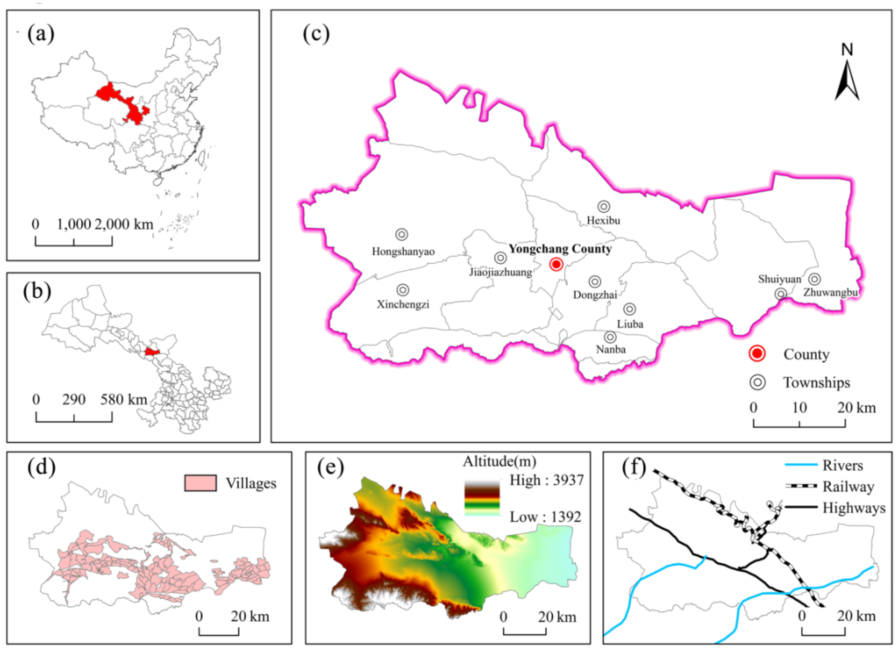
2. Overview of Study Areas

Yongchang County is a county under the jurisdiction of Jinchang City, Gansu Province, China (Figure 1). It is located at longitude 101°04′–102°43′ east and latitude 37°47′–3°′839 north. The longest distance from east to west is 144.8 km, the widest distance from north to south is 144.55 km, and the total area is 7439.27 km2. The terrain is complex, with rivers and canals, mountains and flat rivers, and Gobi oases, with altitudes of 1327–4442 m [38]. The Qilian Mountains are in the south of the territory, and in the north of the territory lies Dragon’s Head Mountain towering stretches; the terrain is high in the southwest and low in the northeast, the areas has a temperate continental climate. Yongchang County is rich in pasture resources, accounting for more than 60% of the county area. Surface water comes from mountain precipitation, high mountain ice, and snow melt water that accumulate in the East River, West River, and Jinchuan River and their tributaries. Groundwater has a wide distribution, but there is little water. It is mainly supplied by precipitation and river way leakage [39]. Due to the county’s location in the inland arid zone, agriculture, industry, and urban water mainly depend on the precipitation in the Qilian Mountains and snow and ice melt from the source of the East River. Yongchang County is one of the water-scarce areas in China and a fragile area of natural ecosystem in the northwest [40].
Yongchang County is an important economic and industrial region in the Hexi Corridor and is the most extensive refining base for nickel, cobalt, and platinum group metals in China [41]. By the end of 2020, Yongchang County had a resident population of 17.76 × 10⁴ people and a GDP of CNY 87.2 × 10⁸. The county governs 9 towns and 1 township, 112 administrative villages, and 916 village groups. The per capita disposable income of rural residents in Yongchang County reached CNY 15,604, a year-on-year increase of 6.9%, and the Engel coefficient was 31.4%. The per capita financial expenditure was twice the income level of farmers. The regional financial expenditure and income level were unbalanced. There is still much room for improvement in the efficiency of public financial expenditures on farmers’ income growth. (accessed on 21 August 2021 http://www.yongchang.gov.cn/). The Lanzhou-Xinjiang Railway, Lianhuo Expressway (G30 line), and G312 line cross the county, an important node in the Silk Road Economic Belt [42]. Due to the large geographical area and population in Yongchang County, the countryside as a whole is still in the underdeveloped stage. It is limited by the special topography, the low mechanization, and the weak market competitiveness of agricultural production. There are great differences in the internal land-use structures of regional rural space and rural development [43]. In Yongchang County, vegetable, grass, and livestock production is the leading industry in rural areas, and some villages have achieved certain development in emerging agriculture and cultural tourism; however, the agricultural scale is low, and the industrial development is insufficient [44]. In addition, Yongchang County has a lower urbanization rate than the national average; considerable development problems among different regions; apparent gaps in rural functions and value implications as well as supply and demand; and significant differences in agricultural production levels, poverty levels, and infrastructure security. The county’s rural development represents the average development of rural areas in northwest China. It is a microcosm of China’s rural areas based on industrial development and so is a highly typical county to use as a research object.

3. Data Sources and Research Methods

3.1. Data Sources

The data of this paper mainly come from 4 sources: (1) base map: vector administrative boundaries of each administrative village in Yongchang County (1:250,000), from Gansu Provincial Bureau of Surveying and Mapping; (2) remote sensing image: Landsat-OLI image of Yongchang County with spatial resolution of 30 m and less than 1% cloud, from USGS (accessed on 25 July 2021 https://earthexplorer.usgs.gov). The acquisition of vegetation cover, etc., through ENVI 5.3 software processing [45]; (3) terrain Data: topographic relief and elevation data were obtained from geospatial data cloud (accessed on 9 April 2021 http://www.gscloud.cn), through image correction and slope analysis [46]; (4) basic data of administrative villages [47,48]. The basic data on living conditions, environmental health conditions, infrastructure, public service facilities, and social economy of the 112 administrative villages in Yongchang County in 2020 were obtained through field surveys. Based on the participatory rural assessment (PRA), the research group conducted a 14-day village survey in Yongchang County in May 2020 and mastered and understood the geospatial internal environmental conditions, land use, industrial development, family structure, income level, resource status, etc. of the 112 administrative villages to obtain the primary database of multifunctional research in Yongchang County.

3.2. Research Methodology

3.2.1. Construction of a Rural Multifunctionality Evaluation Index System

Rural functions play a role in the combination of complex self-attributes and external environments within a certain geographical scope and have guaranteed effects on modernization and urbanization. From the society, economy, and environment factors, this paper studied the comprehensiveness, comparability, and accessibility of indices for selection with reference to the existing research results [49,50] and the actual characteristics of rural areas in Yongchang County. We constructed a rural function evaluation index system from four dimensions of living guarantee, economic development, agricultural production and ecological background. The index system includes four primary indicators and nine secondary indicators (Table 1).
The function of living guarantee (LG) shows the ability of rural areas to guarantee a certain quality of life for farmers including living accommodations, which is the basis for the development of rural settlements. Drawing on relevant research results [51,52], public services, infrastructure, living environment, and other indicators that characterize the ability of rural areas to provide living service facilities and living standards were selected for evaluation.
The economic development function (ED) shows the upgrading of rural industries and the industrial output efficiency, and the indicators of industrial integration and financial income that can characterize the level of development and economic strength of rural areas; primary, secondary, and tertiary industries are selected for evaluation with reference to existing studies [29,53].
The agricultural production function (AP) focuses on intensive land use and efficient output and reflects the ability of farmers to provide primary products to rural areas through agricultural activities. Referring to relevant literature [54,55], indicators such as factor inputs and large-scale operations that can characterize the level of rural agricultural development and land use structure are selected for evaluation.
The ecological background function (EB) refers to the natural environmental conditions and utility that ecosystems and ecological processes form and maintain for human survival [56], and it is a prerequisite for the existence and performance of other functions in the countryside and towns. Referring to existing research [57], indicators such as resources and topographic conditions that reflect the ability of ecosystems to maintain equilibrium and natural factor inputs are selected for assessment and accounting.

3.2.2. Model of Rural Multi-Functionality Index

1.
Standardization of indicators and calculation of weights
When determining the weights of rural multifunctionality indicators for the 112 evaluation units in Yongchang County, the initial data should be standardized to exclude the influence of the dimension and numerical value on the results. When the index is greater, it is more favorable for the development of the system. We used the positive index calculation Formula (1) for standardization; when the index was smaller, the development of the system was better. The negative index calculation formula (2) was used for standardization [58,59].
Positive indicators:
Z i = X i min ( X i ) max ( X i ) min ( X i )
Negative indicators:
Z i = max ( X i ) X i max ( X i ) min ( X i )
where X i and Z i are the original and standardized values of the i-th indicator in 2019 for 112 evaluation units in Yongchang County, respectively; max( X i ) and min( X i ) are the maximum and minimum values of the i-th indicator, respectively.
In order to minimize the influence of subjective factors on the evaluation results in the process of weight determination, this paper adopted the coefficient of variation with objective assignment to determine the index weights [58,59]:
δ i = D i Z ¯ i
W i = δ i i = 1 n δ i
where δ i , D i , Z ¯ i , and W i are the coefficient of variation, mean square deviation, mean value, and weight value of the i-th indicator (the indicator after dimensionless treatment), respectively.
2.
Calculation of the Comprehensive Index of Rural Multifunctionality
This paper used the weighted sum method to calculate the comprehensive index ( F i ) of rural multifunctionality for each evaluation unit. The greater the value, the better the multifunctionality of the village and vice versa. The formula is
F i = i = 1 n W i × Z i

3.2.3. Rural Multifunctional Trade-Offs/Synergy Analysis Approach

Due to the heterogeneity and diversity of rural functions, it is difficult to maintain a balance among functions. Identifying the trade-offs/synergies among functions can show their imbalances but achieve specific goals. The term “trade-off” refers to the relationship between different functions that are in conflict or competition with each other; “synergy” refers to the mutual gain or loss of different functions under the cooperation of important factors [60,61].
1.
Analysis of trade-offs
When the rural multifunctional index obeyed a normal distribution, its Pearson correlation coefficient (r) was calculated. If one of the categories was not the normal distribution, the Spearman rank correlation coefficient (ρ) was calculated. A significant negative correlation between two rural functions (r or ρ < 0, p < 0.05) indicated a trade-off between them. When two functions were significantly positively correlated, they showed synergy. The strength of trade-offs was further quantified for any two rural functions with trade-offs.
2.
Determination of Production-Possibility Frontiers
Production–possibility frontiers (PPF) are used to represent the maximum number of combinations of various goods that can be produced under given resources and technological conditions under the concept of economics. PPF can quantitatively describe the strength of trade-offs between one or more combinations [62]. The standardized values of all rural multifunctionality values were stacked and aggregated to obtain the comprehensive function index corresponding to the function. The comprehensive function index was ranked in ascending order. The ranking results were used to determine the combination of rural functions that can provide the maximum value. The combination of data was selected to draw a PPF curve, indicating the best trade-off value between two rural functions [63].
3.
Calculation of the trade-off intensity index
If the expression of the PPF curve is y = f(x), the coordinates of any point on this curve are (x, f(x)). If the final direction of the trade-off movement is to reach the optimal combination of the two functions, this optimal state can be considered the equilibrium state. There was only one equilibrium state under the given conditions, i.e., only one PPF curve could be obtained. The formulas are
D PQ = P ( X 0 , Y 0 ) Q ( X , f ( x ) ) = ( x 0 x ) 2 + ( y 0 y ) 2
D PQmin = min { P ( X 0 , Y 0 ) Q ( X , f ( x ) ) } = min { ( x 0 x ) 2 + ( y 0 y ) 2 }
where coordinate point P ( X 0 , Y 0 ) represents the point corresponding to the mean of the two rural functions. D PQ represents the distance from that point to any point Q on the PPF curve. Therefore, when measuring the overall trade-off intensity between two functions (the point corresponding to the mean of the two functions in the region) and the trade-off intensity between two functions in villages and towns, the shortest distance D PQmin from P to the PPF curve is used to represent the trade-off strength index. The greater the distance D PQmin is, the stronger the trade-off intensity, and vice versa.

3.2.4. Rural Multifunctional Disorder Diagnostic Model

According to the village multifunctional barrier diagnostic [64] model, we identified and analyzed the degree of village sub-functional disorder. This can provide scientific guidance for the development of functional village governance paths in different types of villages.
O m i = { 1 X m i , X m i 1 0 , X m i 1
V m i = F m i × O m i i = 1 n ( F m i × O m i ) × 100 %
where F m i is the factor contribution degree, which represents the contribution of the m-th type function i indicator to the multifunctionality of the rural territory, expressed by indicator weights. O m i is the degree of deviation of the multifunctional evaluation indicator of rural settlement, that is, the difference between 1 and the standard value of a single indicator. V m i is the degree of obstacle of the mth type function i indicator to the multiple functions in a rural area.

4. Analysis of Results

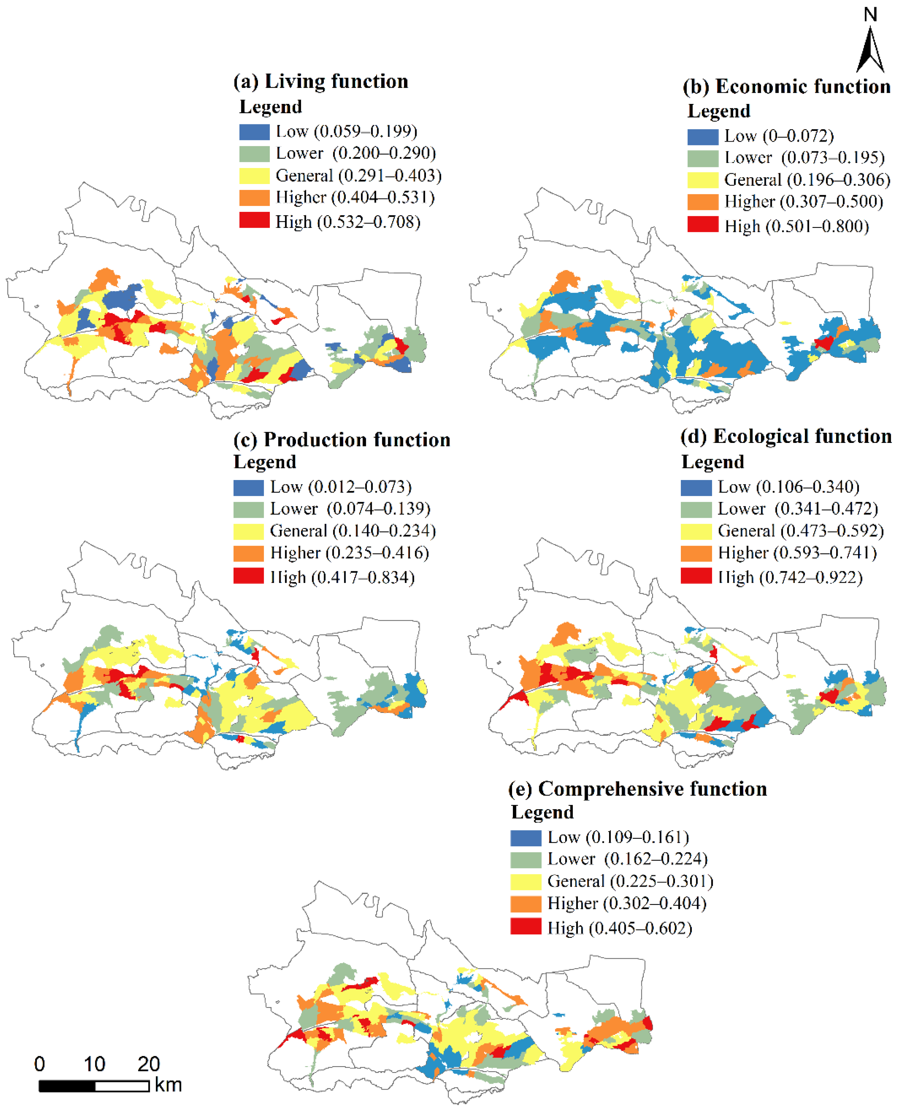
4.1. Evaluation of the Spatial Differentiation of Rural Multifunctionality

With the help of ArcGIS (Figure 2), the living guarantee function, economic development function, agricultural production function, ecological background function, and comprehensive function index of 112 administrative villages in Yongchang County were visualized and classified into five classes using the natural breakpoint method: low-value area, lower-value area, median-value area, higher-value area, and high-value area (Figure 2).
The index of living guarantee function is generally high, with an average score of 0.3533, dominated by higher- and median-value areas, with the numbers of administrative villages reaching 25 and 38, respectively, and accounting for 57.14% of the evaluation units. The number of low-value areas is relatively small, accounting for only 11.60% of the total evaluation units. The living guarantee function shows a spatial pattern of high in the west and low in the east. The living guarantee function of the central and western regions is better than that of the eastern regions. The economic development function index is generally low, with an average score of only 0.1183, dominated by low-value areas, with the number of administrative villages reaching 68, accounting for 60.71% of all evaluation units, with a large distribution range. The high-value areas contain only 1 administrative village, accounting for 0.89% of all evaluation units. The overall economic development function is low, spatially showing a pattern of high in the surrounding areas and down in the central region. The agricultural production function index is generally low, with an average score of 0.1674, dominated by low-value and lower-value areas, with the numbers of administrative villages reaching 26 and 32, respectively, accounting for 51.79% of the total evaluation units. The number of high-value areas was the lowest, with only 6 administrative villages, accounting for 5.36% of the total evaluation units. Spatially, the distribution pattern in the western region was higher than that in the central and eastern regions. The ecological background function index was generally good, with an average value of 0.5332, dominated by median- and higher-value areas, with the numbers of administrative villages reached 37 and 27, with the number of their administrative villages accounting for 57.14% of the total. However, the number of low-value areas is smaller, accounting for only 11.61% of the total number of administrative villages. Spatially, it shows a pattern of high in the western region and low in the eastern region, and the high-value and higher-value areas are mainly distributed in the part west of Yongchang County.
The average comprehensive function index was 0.2577, with the largest number of median-value areas and the number of administrative villages reaching 36, accounting for 32.14% of the total number of evaluation units. The numbers of administrative villages in higher-value and lower-value areas were 19 and 33, respectively, accounting for 16.96% and 29.46% of the total number of evaluation units. The numbers of administrative villages in high-value areas and low-value areas were 9 and 15, respectively, accounting for 8.04% and 13.39% of the total number of evaluation units. The comprehensive development function shows a spatial pattern of high in the north and low in the south. The high-value areas are mainly distributed in the west, east, and north of the county in a plane and strip shape. The development of agriculture and industry is relatively good, providing good jobs for residents and good per capita income for rural residents. The comprehensive effect of the function is significant.

4.2. The Measurement of Rural Multi-Functional Trade-Offs/Synergy

4.2.1. Rank Correlation of Multiple Rural Functions

In order to explore the trade-offs or synergy relationship among rural functions, Spearman rank correlation analysis was conducted for each function in the 112 administrative villages in Yongchang County, and the results are shown in Table 2 and Figure 3. It can be seen that: (1) The synergistic effect among the functions of living guarantee, ecological background, and agricultural production was significant (significance level of 0.01), indicating that agricultural production provides a good economic basis for residents with a good economic foundation, and better ecological conditions can promote the coordinated development of agriculture. (2) The trade-offs among the living guarantee, ecological background, and economic development functions were significant. The trade-off between living guarantee function and ecological background function was the most significant (−0.245), followed by the trade-off between economic development function and ecological background function. This indicates that the development of social and economic services in Yongchang County’s countryside contradicts ecological protection. In order to meet living needs and economic growth, planning and building new rural communities, improving rural infrastructure facilities, improving living conditions, and developing modern agriculture all take up ecological service resources, which to a certain extent, limits the maintenance of the environmental environment. (3) The synergistic relationship between the economic development, living guarantee and agricultural production functions was weak and insignificant in Yongchang County. In general, the development of multiple rural functions in Yongchang County shows a coordinated performance that provides a good foundation for realizing the coordination of the living guarantee function and the ecological background function and gradually transforming the function structure.

4.2.2. Quantification of Rural Multi-Functional Trade-Offs

Based on the PPF, a quantitative expression of the prominent functional combinations in the rural multi-functional trade-off was carried out. The trade-off or synergy PPF curves including trade-offs between living or economic–ecological functions and synergy between living or ecological–agricultural functions were drawn.
The trade-off between the ecological background function and the living guarantee function was a nonmonotonic curve concave to the origin (Figure 4a). When the ecological background function changed from a (0.100,0.329) → b (0.200,0.356), the living guarantee function showed synergy with the ecological background function. When it changed from c (0.500,0.368) → d (0.600,0.348) and from e (0.700,0.316) → f (0.800,0.272), the opportunity cost of the living guarantee function decreases by 0.020, 0.044 for each 0.1 increase in the ecological background. The opportunity cost of giving up the living guarantee function increases for every equal increase in the ecological background function input. This indicates that the more additional input to the ecological background function, the less conducive to the living guarantee function. The total benefit of the ecological background and living guarantee functions was weakened.
The trade-off between the ecological background function and the economic development function is a nonmonotonic curve convex to the origin (0,0) (Figure 4b). The opportunity costs of reducing the ecological background function from a (0.100,0.225) → b (0.200,0.187) and from c (0.400,0.131) → d (0.500,0.113) were 0.038 and 0.018, respectively. In other words, the opportunity cost of economic development was weakened with each equal increase in ecological background input. When the ecological background function changed from e (0.800, 0.079) → f (0.900, 0.105), it indicated that the economic development function developed with the continuous input of the ecological background function, and the relationship between the two gradually changed from trade-off to synergy.
The synergistic relationship between the living guarantee function and the agricultural production function was a convex curve concave toward the origin (Figure 4c). When the combination increased from a (0.200,0.372) → b (0.400,0.432) and from c (0.600,0.468) → d (0.800,0.480), the opportunity costs of the reduction of the living guarantee function decreased to 0.060 and 0.012, respectively. This indicates that with the input of the agricultural production function, the living guarantee function showed a lower promotion effect, and it is necessary to strengthen relevant measures to promote the synergistic growth between the two.
The synergistic relationship between the ecological background function and agricultural production function was similarly a convex curve concave to the origin (Figure 4d). When the combination changed from a (0.200,0.114) → b (0.300,0.132) and from c (0.600,0.174)→d (0.700,0.184), the opportunity cost of the reduction of the living function decreased from 0.018 to 0.01. This indicates that with a change in the agricultural production function, the promotion of the ecological background function showed a gradual weakening trend. It is necessary to strengthen the maintenance of the ecological background function to enhance the agricultural production function, adapt the resources and topography to the ecological background, and facilitate their synergy.

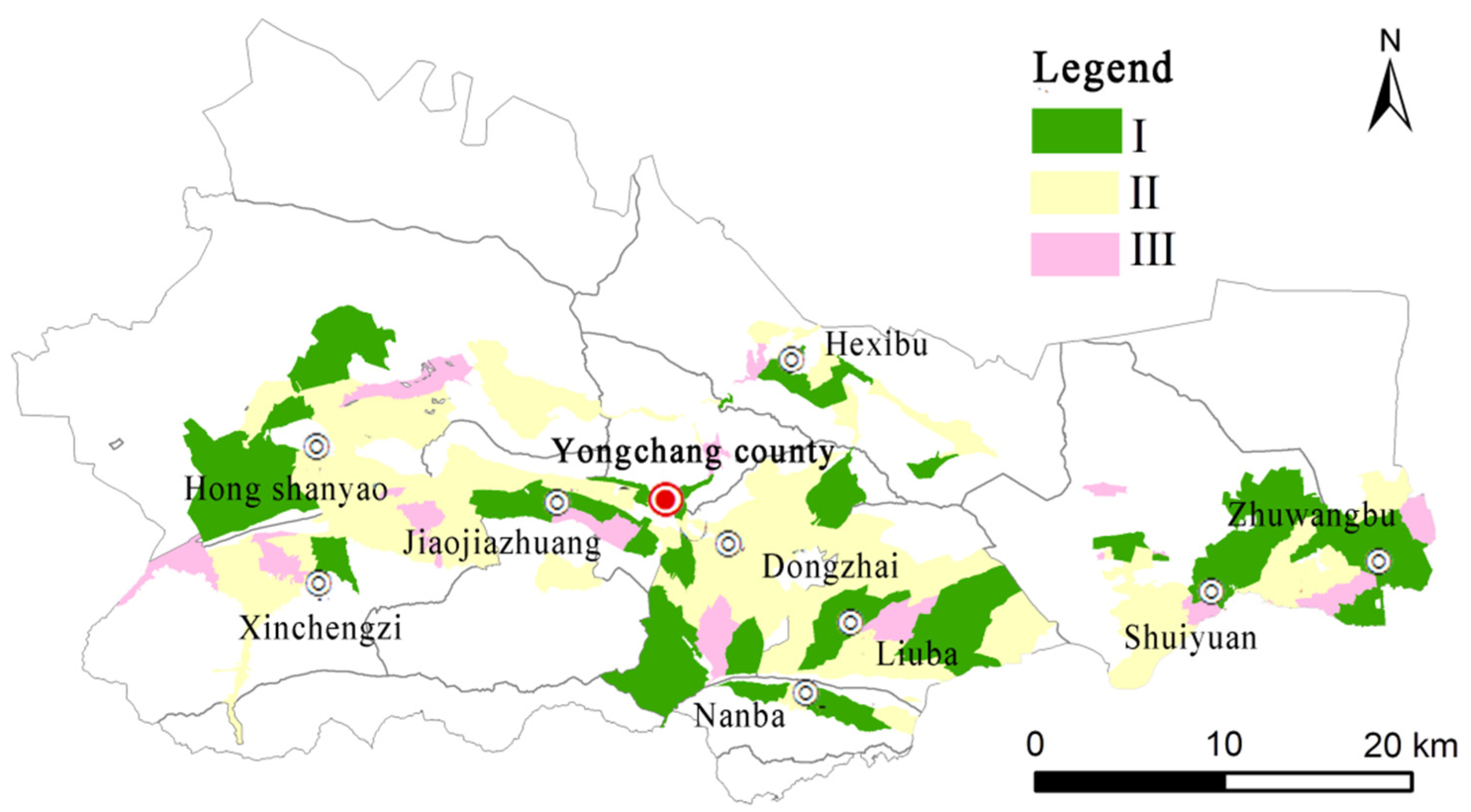
4.3. Classification of Village Types under the Trade-Off of Rural Multi-Functions

In order to deeply analyze the development characteristics of rural multifunctionality in Yongchang County, we identified types of villages under the trade-off of rural functions through the trade-off intensity index among the living guarantee function, the economic development function, and the ecological background function. The trade-off intensity of the ecological background–living guarantee function, 0.0111, was lower than that of the economic development–ecological background function (0.4138). This indicates that the closer the ecological background–living guarantee function combination point is to the shortest optimal combination point on the production possibility overbound, the more efficient equilibrium of the two can be achieved by adding fewer inputs to the function. The economic development–ecological background function combination point was at a greater distance from one of the optimal combination points with the shortest distance on the PPF. There was a greater conflict between the two. It is necessary to limit the development of one function to support the other function. Therefore, based on the finding of the lower the intensity of the trade-off, the greater the symbiotic development between functions, and the higher the trade-off intensity, the more only one function is developed at most, the trade-off intensity indexes of living guarantee–ecological background function and economic development–ecological background function were divided into three levels of 3, 2 and 1, representing high, median and low trade-off, respectively (Table 3).
Based on the evaluation results for village functions in Yongchang County and the impacts of village functions, industrial development, and ecological livability on rural development, we identified the levels of village development in Yongchang County as Class I, Class II, or Class III according to the similarities to dominant types of villages and the comprehensive judgment of the combinations of village function trade-offs (Figure 5).
The comprehensive upgrading villages (Class I) include 55 administrative villages, mainly distributed in blocks and strips at the edge of the county. The intensity of the trade-off among the functions of regional living guarantee, economic development and ecological background in this category of villages was weak. Among them, villages distributed on the edge of the county are represented by their comprehensive functions. This indicates that under the existing conditions, the continued development of these three functions can optimize these villages’ benefits from combining functions.
Synchronous optimization villages (Class II) include 43 administrative villages, mainly distributed in the central and western areas. Only one combination, production and ecological functions or living and ecological functions, in these villages had a trade-off intensity above medium. For these villages, we should focus on optimizing economic development and ecological background functions through ecological tourism development and the rational construction of industrial and mining enterprises to ease the trade-offs between the functions.
Key development villages (Class III) include 15 administrative villages that are mainly scattered throughout the county in a dotted pattern. The trade-offs among the functions of living guarantee, economic development, and ecological background in these villages were intense. In addition, poor housing conditions, weak industrial foundation, insufficient ecological governance, and the aggravating effects of population aging and rural hollowing have given the living guarantee, economic development, and ecological background functions low values. These villages should moderately restrict the development of other functions after determining the priority function to develop.

4.4. Diagnosis of Dysfunction in Different Rural Development Zones

In order to realize the multifunctional coordinated development of rural areas in Yongchang County, the barriers were measured for different rural multi-functional development zones (Table 4). The mean value of a barrier characterizes its intensity: the higher the mean, the stronger the barrier. The impact rate represents the probability of occurrence of nine barriers in different spatial subdivisions. It is used to characterize the impact range of a barrier. The higher the impact rate, the greater the number of administrative villages affected by the barrier.
The top five obstacles in Class I villages are, in descending order of the number of affected administrative villages, living environment, income level, scale operation, factor input, and topographic conditions. Among them, the influence rate of the living environment function reached 84.62%; the poor living standards are the barrier to the living guarantee function in these areas. The poor public services, lack of basic security, and industrial homogeneity are also important limits to improving multifunctionality.
The top five obstacles in Class II villages, also in descending order of the number of affected administrative villages, were income level, industrial integration, living environment, scale operation, and topographic conditions. The influence rate of income level was 81.82%. Limited public services affect the quality of rural life, and the agricultural production and climatic conditions are important barriers to rural production and ecology. In addition, these areas face problems such as the worrying quality of rural housing and the lack of infrastructure.
The top four obstacles in the Class III villages, in descending order of the number of affected administrative villages, were scale operation, industrial integration, income level, and public services. Among them, the combined influence rate of infrastructure function and scale operation function was 72.73%. This seriously restricts the development of the rural ecological background function and becomes the key to improving rural multifunctionality in this type of village. The lack of public services has seriously affected the living guarantee function in the region. The improper treatment of emissions from living and production activities has caused damage to the ecological environment. The combined effects of these barriers functions present these villages with industrial, residential and ecological disadvantages.

5. Discussion and Conclusions

5.1. Discussion

There are significant differences in environmental quality, natural conditions, resource supply and development capacity among the municipalities of Yongchang County. This significant gap also exists in the presentation and effect intensities of various functions between villages, specifically intense versus light trade-offs between rural functions. Due to the combined effects of various factors such as regional administration, capital, society, and market, different types of villages have developed. When designing their governance paths, we should give priority to research from the three dimensions of government power, market power, and social power. Focusing on the differences in the function patterns of the villages in Yongchang County, including the synergistic relationships between the trade-offs in each subdistrict and the degree of influence of the barriers, we followed the governance principle of upgrading the weak function trade-offs, optimizing the middle function trade-offs, and developing the high function trade-offs with the development goal of “guiding by exogenous power and renewing by endogenous power”. The existing defects in different rural development types were sorted and summarized, and the integration of their resource elements was adjusted (Figure 6) to improve the social, economic, and physical space of the countryside, strengthen the differentiated functional configuration of the countryside, and promote high-quality rural development.
(1)
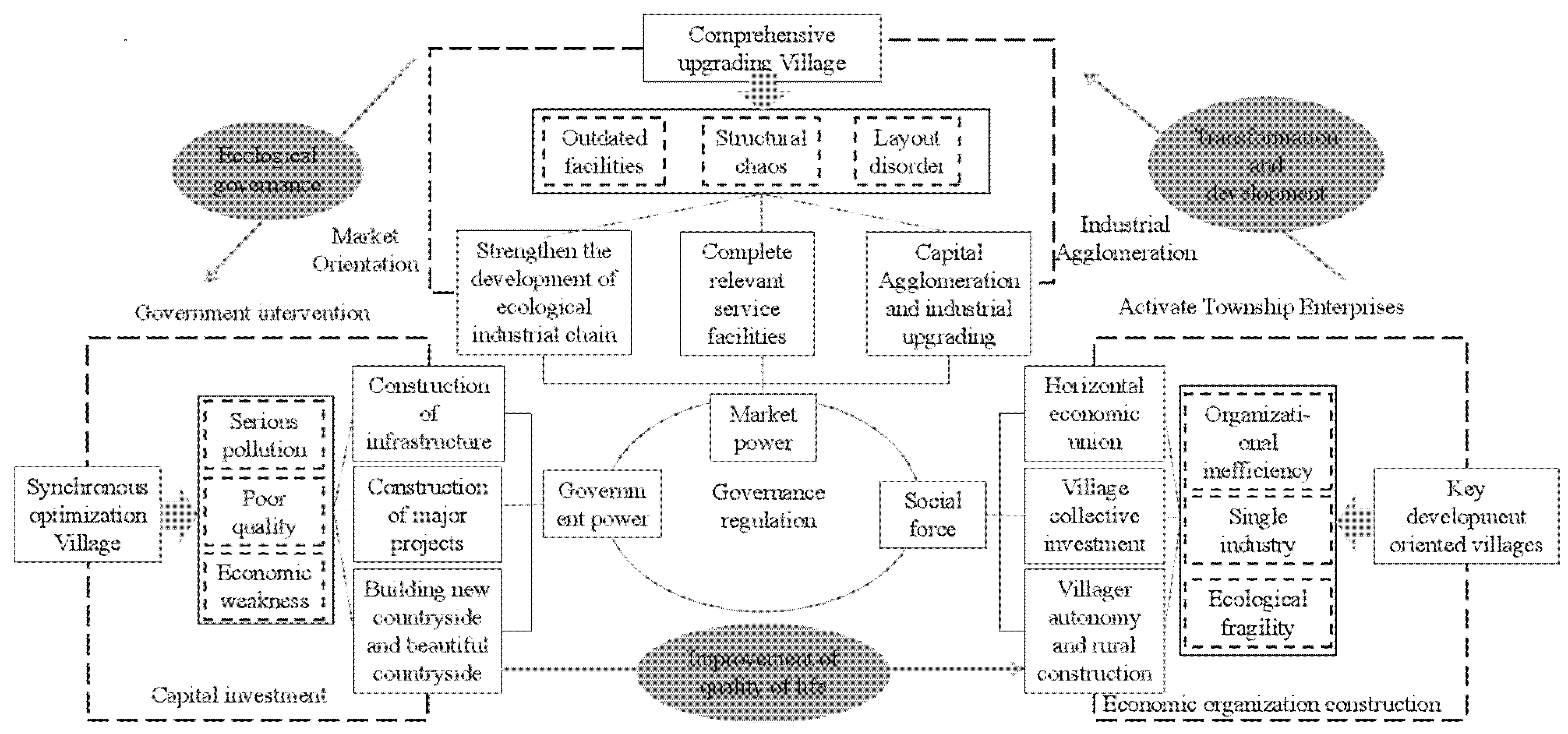
Comprehensive upgrading village. This is a weak trade-off area between the living guarantee/economic development functions and the ecological environment. In the future, we should focus on toilet renovation, garbage and sewage treatment, and village appearance improvement as well as improving infrastructure such as roads, water supply, and basic public services such as education and medical care. We should comprehensively promote high-quality special agricultural products according to local conditions, create regional brands of agricultural products, and improve the quality of agricultural products. In addition, the government should further develop product sales and related markets through self-media methods such as e-commerce platforms and live broadcasts. We also need to pay attention to and protect the ecological environment and revitalize natural resources such as forests and grasslands through the Ant Forest project and developing eco-tourism and other industries. The government should implement a strict ecological protection system, strengthen the monitoring of pollution by enterprises and the loss of species diversity in a given area, and coordinate and control the ecological quality of the water space. In addition, the government should use the transformation of rural house foundations as part of improving rural living conditions, further speeding up construction upgrades to improve the living environment of farmers, as well as increase space utilization.
(2)
Simultaneous optimization of villages. The district has a high degree of trade-off among the living guarantee, economic development, and ecological background functions. The government should fully consider the variability of social relations, build and strengthen grass-roots organizations, improve the rural governance system led by village party organizations with the participation of multiple parties, and pay attention to training local talents in the countryside. The government should increase the financial support for and investments in land utilization, agriculture, and forestry and public services such as education and medical care including elder care and enhance the value of both agricultural and nonagricultural production. In addition, the government should improve industrial zones and related facilities, raise the entry threshold of rural industries, avoid industrial homogenization, and form core competitiveness in the market. The government should improve the supporting infrastructure in poor areas, effectively cover areas with public service resources, and improve the ability to build and share public services together. The government should continue to improve the rural living environment, achieve green development, reduce the application of pesticides and fertilizers through standardized adjustment, and investigate and rectify rural non-point source pollution. In addition, we must improve the rural land resources across the whole area, strictly control the loss of rural ecological space, maintain the stability of ecological space, and build an environment-friendly countryside from a high starting point.
(3)
Focused development countryside. The trade-off between the functions of the villages in this area is dramatic. We should mobilize rural development enthusiasm, cultivate new rural business, adopt suggestions for residents’ living needs, develop multiple functions such as recreation and leisure and cultural experience, adjust and optimize internal space; reclaim and re-green long-idle residential foundations and revitalize other idle resources, enhance rural production and living functions, and promote new vitality for industrial development. The government should strengthen the villages and market towns with industrial clustering and population inflow. We should conduct appropriate advance planning, increase construction investment, and improve the population and economic carrying capacity. Through village development, we should mobilize the enthusiasm of village collectives and villagers for development.

5.2. Highlights and Recommendations

Inadequate and unbalanced development of rural areas leads to uncoordinated rural functions. In the new development stage, enhancing rural functions as a development director to serve the rural revitalization strategy is essential to activating regional economies and continuously promoting high-quality rural development. Based on the multifunctional characteristics of the countryside within Yongchang County in the western corridor of China, this study uses a trade-off synergy model, Spearman’s rank correlation coefficient, and production possibility boundaries to link the ecosystem service trade-off intensity model to the exploration of multifunctional trade-off and synergy relationships in the countryside by constructing an index system for evaluating the rural multifunctionality in the countryside in Yongchang County; these results can determine the trade-off intensity between the superposition of optimal functions in the region. Next, by diagnosing the barriers in areas with low levels of rural multifunctionality and imbalanced factor allocation, this study clarifies the current status of barriers in each spatial subdivision. It proposes corresponding treatment paths to create a more balanced relationship between rural and land resource allocation and multifunctional supply and demand. This study can help explore the multifunctional value of the countryside, strengthen the countryside’s resilience, and improve the integration of traditional single industries and new industries.
The study of the trade-off and synergistic relationships between rural multifunctionality and obstacles based on village and town scale has enriched the theoretical system of rural multifunctionality to a certain extent and provided a reference for the future development direction of rural areas. The specific recommendations of this study are as follows: (1) fully consider the specificity of regional geographic space, improve the potential of land use, continuously explore the development characteristics of rural functions, strengthen the advantages of the utilization of rural functions among local conditions, seek the efficient allocation of regional resources, and promote sustainable rural economic and social development; (2) stabilize arable land protection, strictly adhere to the red line of arable land, make adequate adjustments to the agricultural cultivation structure based on strengthening the construction of high-standard farmland, activate rural agricultural production functions, and continuously improve the ability to guarantee national food security; (3) on the premise of ensuring the effective supply of agricultural products, extend the agricultural industry chain, seize industrial development opportunities, drive advantageous regional industries, expand employment opportunities and non-farm income channels for farmers, and promote rural economic development; (4) focus on infrastructure construction, strengthen the quality of the rural living environment and social security, reduce the employment pressure of rural residents, make it a priority to promote rural life security functions, and improve villagers’ rural education and residents’ sense of well-being; (5) focus on the protection of the environment, strengthen the management of regional soil erosion, encourage public financing to strengthen investment in ecological restoration and species protection, bring into play the ecological background functions of the countryside, promote the development of modern ecological recycling industries, and deeply explore the natural binding force and government intervention power to highlight the ecological value of local villages.

5.3. Conclusions

(1)
In the rural multifunctional space in Yongchang County, the function patterns of living guarantee, agricultural production, and ecological environment converge. The function patterns of living guarantee and ecological environment are the closest. Both are better in the central and western regions than that in the eastern regions. The agricultural production function shows significant regional differences. The agricultural production function in the eastern region is generally better than that in other regions. The economic development function has low similarity with other function patterns. The function index of townships close to the outer edge is higher than that in other regions. The comprehensive functions in the countryside are better in the western, eastern, and northern townships of the county in terms of agriculture and industry. The function index shows a distribution pattern of high in the north and low in the south.
(2)
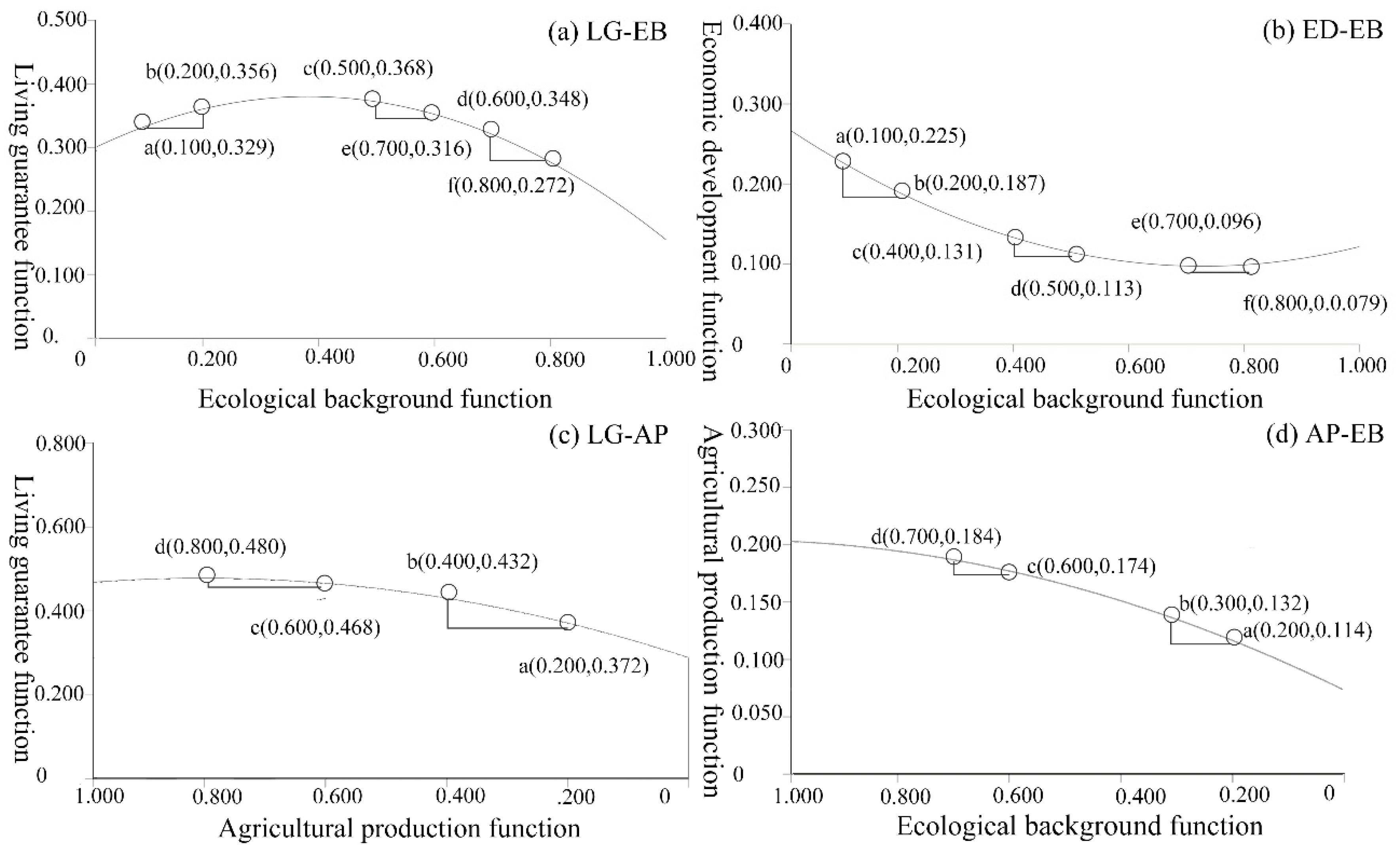
The trade-off and synergy relationships between rural functions in Yongchang County are significant. The trade-off and synergy PPF curves show that the overall trade-off between the living guarantee function and the ecological background function will be intensified with the sustainable development of the ecological background function. The trade-off between the economic development function and the ecological background function shows that with the continuous development of the ecological background function, the trade-off relationship between the two weakens. The synergistic effect between the living guarantee/ecological background function and the agricultural development function gradually weakened with the input of the agricultural development function.
(3)
The 112 administrative villages in Yongchang County are divided into three types of villages: comprehensive upgrading, synchronous optimization, and key development based on the trade-off intensity index. In 2020, villages in Yongchang County were mainly the comprehensive upgrading and synchronous optimization types, reaching 55 and 43 administrative villages, respectively, and accounting for 86.73% of all evaluated villages. The number of key development type was relatively small at 15, accounting for 13.27% of all evaluated villages.

Author Contributions

L.M. and Y.L. designed the study, processed the data, and gave comments and suggestions on the manuscript. All authors contributed to the results, related discussions, and manuscript writing. Writing-Original Draft, L.M.; Methodology, L.M.; Formal analysis, L.M.; Visualization, L.M.; Supervision, Y.L.; Project administration, Y.L.; Resources Y.L.; Data curation, X.C.; Investigation, X.C.; Software, T.T.; Formal analysis, T.T. All authors have read and agreed to the published version of the manuscript.

Funding

This research was funded by the National Natural Science Foundation of China, grant number 41961033; the National Natural Science Foundation of Gansu Province, grant number 20JR5RA519; and National Natural Science Foundation of China, grant number 42101276.

Informed Consent Statement

Informed consent was obtained from all subjects involved in the study.

Data Availability Statement

The data presented in this study are available on request from the corresponding author.

Acknowledgments

Authors express great thanks for the financial support from National Natural Science Foundation of China.

Conflicts of Interest

The authors declare no conflict of interest.

References

  1. Hu, X.L.; Li, H.B.; Zhang, X.L.; Yuan, Y. On the re-cognition of rural definitions. Acta Geogr. Sin. 2020, 75, 398–409. [Google Scholar]
  2. Zhou, S.Y. Four layers in one: The way to excavate the traditional rural locality. Tour. Trib. 2017, 32, 6–7. [Google Scholar]
  3. Xu, K.; Fang, Y.G. Rural Multi-Function Evaluation and Evolution Characteristics in Liaoning Province. Econ. Geogr. 2021, 41, 147–157. [Google Scholar] [CrossRef]
  4. Woods, M. Rural Geography; SAGE Publications: London, UK, 2005. [Google Scholar]
  5. Van HuylenBroek, G.; Durand, G. New opportunities for noncompetitive agriculture. In Multifunctional Agriculture: A New Paradigm for European Agriculture and Rural Development; Ashgate Publishing: Aldershot, UK, 2003; pp. 169–188. [Google Scholar]
  6. Hong, H.K.; Liao, H.P.; Li, T. Analysis of spatio-temporal patterns of rural space function based on entropy value method and Dagum Gini coef-ficient. Trans. CSAE 2016, 32, 240–248. [Google Scholar]
  7. Liu, Y.S.; Liu, Y.; Chen, Y.F. Territorial Multi-functionality Evaluation and Decision-making Mechanism at County Scale in China. Acta Geogr. Sin. 2011, 66, 1379–1389. [Google Scholar]
  8. Wiggering, H.; Dalchowa, C.; Glemnitz, M.; Helming, K.; Müller, K.; Schultz, A.; Stachow, U.; Zander, P. Indicators for multifunctional land use-Linking socio-economio requirements with landscape potentials. Ecol. Indic. 2006, 6, 238–249. [Google Scholar] [CrossRef]
  9. Ding, S.B. Some basic theoretical issues faced with plan of essential function region system. Sci. Geogr. Sin. 2009, 29, 587–592. [Google Scholar]
  10. Peter, K.; Annandale, D.; Bailey, J. Integrated economic and environmental planning in Asia: A review of progress and proposals for policy reform. Progr. Plann. 2003, 59, 233–315. [Google Scholar]
  11. Liu, Y.; Liu, Y.S. Progress and Prospect in the Study of Rural Region Multifunctions. China Popul. Resour. Environ. 2012, 22, 164–169. [Google Scholar]
  12. Li, B.H.; Zhou, X.; Liu, P.L.; Chen, C.; Liu, Y.M. Function Transformation and Spatial Reconstructuring of Zhangguying Village in Urbanization. Sci. Geogr. Sin. 2018, 38, 1310–1318. [Google Scholar] [CrossRef]
  13. Marsden, T. Rural Geography Trend Report: The Social and Political Bases of Rural Restructuring. Prog. Hum. Geogr. 1996, 20, 246–258. [Google Scholar] [CrossRef]
  14. Appendini, K. Reconstructing the Maize Market in Rural Mexico. J. Agrar. Chang. 2014, 14, 1–25. [Google Scholar] [CrossRef]
  15. Prothmann, S. Migration, masculinity and social class: Insights from pikine, senegal. Int. Migr. 2018, 56. [Google Scholar] [CrossRef]
  16. Tang, L.N.; Liu, Y.; Pan, Y.C.; Ren, Y.M. Evaluation and Zoning of Rural Regional Multifunction Based on BP Model and Ward Method: A Case in the Pinggu District of Beijing City. Sci. Geogr. Sin. 2016, 36, 1514–1521. [Google Scholar] [CrossRef]
  17. Zhu, Y.; Yang, X.Z.; Yang, Z.; Zhen, Y.G.; Yang, W.M.; Zhen, H.Y. Evolution characteristics and mechanism of rural multifunctionality in south Anhui tourism area based on major function-oriented zones. Sci. Geogr. Sin. 2021, 41, 815–823. [Google Scholar] [CrossRef]
  18. Xiao, L.S.; Yu, Z.W.; Ye, H.; Zhang, G.Q. The research of coupling rural development and economy cluster in Fujian Province. Acta Geogr. Sin. 2015, 70, 615–624. [Google Scholar]
  19. He, Y.H.; Fan, S.G.; Zhou, G.H.; Tang, C.L.; Peng, P. Evaluation of rural transformation development in Hunan Province based on major function oriented zoning. Prog. Geogr. 2018, 37, 667–676. [Google Scholar]
  20. Fu, C. The Evaluation of Rural Territorial Functions: A Case Study of henan, China. J. Resour. Ecol. 2017, 8, 242–250. [Google Scholar]
  21. Zhang, B.T.; Min, Q.W.; Jiao, W.J.; He, S.Y.; Liu, M.C.; Yang, L. Research progress and perspective on ecosystem services trade-offs. Acta Ecol. Sin. 2021, 41, 5517–5532. [Google Scholar]
  22. Liang, C.; Zeng, J. Three-dimensional dynamic identification and spatial evolution mechanism of urban-rural fringe: A case study of Xiamen. Sci. Geogr. Sin. 2021, 40, 1404–1420. [Google Scholar]
  23. Liu, H.C.; Ren, C.Y.; Wang, Z.M.; Zhang, B. Dynamics of Ecosystem Service Functions and their Trade off and Synergetic Relationships in Great Xing’an Mountains Ecological Function Zone. J. Ecol. Rural. Environ. 2021, 38, 587–598. [Google Scholar] [CrossRef]
  24. Niu, L.N.; Shao, Q.Q.; Ning, J.; Huang, H.B. Ecological changes and the tradeoff and synergy of ecosystem services in western China. Acta Geogr. Sin. 2022, 77, 182–195. [Google Scholar] [CrossRef]
  25. Wang, J.N.; Chen, H.; Shi, Q.Q.; Liu, D.; Liang, X.Y. Research on spattal-temporal differentiation and influencing factors of land use multifunctional areas of Shaanxi province. Chin. J. Agric. Resour. Reg. Plan. 2019, 40, 101–108.11. [Google Scholar]
  26. Zhang, Y.Y.; Tang, L.N.; Liu, Y. Rural Function Zoning and Approaches for Rural Revitalization in the Beijing-Tianjin-Hebei Region. Econ. Geogr. 2020, 40, 160–167. [Google Scholar] [CrossRef]
  27. Chen, A.; Li, J.J.; Zhang, M.S.; Zhang, H.; Bian, L.J.; Li, W.T.; Xu, W.L. Research for Change of Ecosystem Service and the Tradeoff-Synergy Relation of the YLN Basin in the Tibet Autonomous Region. Res. Soil Water Conserv. 2022, 29, 313–319+329+2. [Google Scholar] [CrossRef]
  28. Yao, L.; Liu, Y.T. Rural Development Types in Peri-Urban Areas Based on Cluster Analysis: A Case Study of Conghua, Guangzhou. Trop. Geogr. 2015, 35, 427–436. [Google Scholar]
  29. An, Y.; Zhou, G.H.; He, Y.H.; Mao, K.B.; Tan, X.L. Research on the functional zoning and regulation of rural areas based on the production-life-ecological function perspective: A case study of Changsha-Zhuzhou-Xiangtan area. Sci. Geogr. Sin. 2018, 37, 695–703. [Google Scholar] [CrossRef]
  30. Xie, G.D.; Zhen, L.; Zhang, C.X.; Deng, X.Z.; Koenig, H.; Tscherning, K.; Helming, K. Assessing the multifunctionalities of land use in China. J. Resour. Ecol. 2010, 1, 311–318. [Google Scholar]
  31. Ran, N.; Jin, X.B.; Fan, Y.T.; Xiang, X.M.; Liu, J.; Zhou, Y.K.; Shen, C.Z. Study on the method of “three lines” delimitation based on the identification and coordination of land use conflict: A case study of Jintan district of Changzhou city. Resour. Sci. 2018, 40, 284–298.1. [Google Scholar]
  32. Lu, L.G.; Zhou, S.L.; Zhou, B.B.; Dai, L.; Chang, T.; Bao, G.Y.; Zhou, H.; Li, Z. Study on land use transformation and its eco-envi-ronmental response in the process of regional development: A case study of Jiangsu province. Sci. Gieograph. Sin. 2013, 33, 1442–1449. [Google Scholar]
  33. Liu, J.L.; Liu, Y.S.; LI, Y.R. Classification evaluation and spatial-temporal analysis of “Production-Living-Ecological” spaces in China. Acta Gieograph. Sin. 2017, 72, 1290–1304. [Google Scholar]
  34. Liu, Y.; Jiang, Z.; Wang, H.S. Spatial differentiation of agricultural regional function in Beijing and its influencing factors. J. Nat. Resour. 2020, 35, 2444–2459. [Google Scholar] [CrossRef]
  35. Tan, X.L.; An, Y.; Su, Y.; Zhou, G.H.; He, Y.H. Spatio-temporal dynamics of agricultural function in Changsha-Zhuzhou-Xiangtan urban ag-glomerations. Sci. Geogr. Sin. 2018, 38, 708–716. [Google Scholar]
  36. Xu, L.; Dong, J.; Chen, E. Coordination characteristics of land and space utilization of urban agglomeration in the middle reaches of the Yangtze River based on the function of “production-living-ecological”. Soil Water Conserv. Res. 2018, 25, 257–263. [Google Scholar]
  37. Wang, M.; Zhou, Z.X.; Feng, H.J. Coordinated development of urban agricultural multi-functionality of Xi’an metropolitan zone. Arid. Land Geogr. 2015, 38, 858–866. [Google Scholar]
  38. Li, Y.; Beeton, R.J.S.; Sigler, T.; Halog, A. Modelling the transition toward urban sustainability: A case study of the industrial city of Jinchang, China. J. Clean. Prod. 2016, 134, 22–30. [Google Scholar] [CrossRef]
  39. Ma, L.B.; Dou, H.J.; Wu, S.S.; Shi, Z.H.; Li, Z.Y. Rural development pressure and “three-stay” response: A case of Jinchang City in the Hexi Corridor, China. J. Rural. Stud. 2022, 91, 34–46. [Google Scholar] [CrossRef]
  40. Li, T.S.; Chen, X.Y.; Rui, Y.; Yang, K. Strategy and Path of Cooperative Promotion of Ecological Protection and High-quality Development in Northwest China. Econ. Geogr. 2021, 41, 154–164. [Google Scholar]
  41. Li, Y.; Beeton, R.J.S.; Anthony, H.; Sigler, T. Evaluating urban sustainability potential based on material flow analysis of inputs and outputs: A case study in Jinchang City, China. Resour. Conserv. Recycl. 2016, 110, 89–98. [Google Scholar] [CrossRef]
  42. Wu, L.; Huo, L. The Resurch of Relationship Between Node Cities in Silk Road Economic Zone. J. Northwest Univ. (Philos. Soc. Sci. Ed.) 2015, 45, 111–118. [Google Scholar]
  43. He, X.N.; Da, X.J.; Tan, Z. Study on the current situation of village layout in Yongchang County. Gansu Sci. Technol. 2015, 31, 1–4, 140. [Google Scholar]
  44. Tang, Y.F.; Zang, D.W.; Qiao, D.H.; Li, H.X.; Gao, J. The comprehensive evaluation on agricultural modernization of cities in Gansu province. Chin. J. Agric. Resour. Reg. Plan. 2020, 41, 198–206. [Google Scholar]
  45. Wang, N.; Du, Y.Y.; Lliang, F.Y.; Wang, H.M.; Yi, J.W. The spatiotemporal response of China’s vegetation greenness to human socio-economic activities. J. Environ. Manag. 2022, 305, 114304. [Google Scholar] [CrossRef] [PubMed]
  46. Wang, Z.Y.; Deng, W.; Zhang, S.Y.; Zhang, H. Correlation analysis of land use multi-functionalization and transitional geo-space in mountainous areas: Taking Changning County as an example. Sci. Geogr. Sin. 2022, 42, 1091–1101. [Google Scholar]
  47. Qu, Y.B.; Jiang, G.H.; Zhao, Q.L.; Ma, W.Q.; Zhang, R.J.; Yang, Y.T. Geographic identification, spatial differentiation, and formation mechanism of multifunction of rural settlements: A case study of 804 typical villages in Shandong Province. China J. Clean. Prod. 2017, 166, 1202–1215. [Google Scholar] [CrossRef]
  48. Zhao, Q.L.; Jiang, G.H.; Yang, Y.T.; Tian, Y.Y.; Fan, L.H.; Zhou, T.; Tian, Y.Y. Multifunction change of rural housing land in metropolitan suburbs from the perspective of farmer households’ land-use behavior. Land Use Policy 2022, 119, 106206. [Google Scholar] [CrossRef]
  49. Hong, S.Q.; Li, J.F. The Spatial Pattern and Formation Mechanism of Rural Area Function in Anhui Province. J. Anhui Agric. Sci. 2021, 49, 216–221. [Google Scholar]
  50. Yang, R.; Zhang, J.; Chen, Y.C. Differentiation and dynamic mechanism of rural devel opment in metropolitan fringe based on the functional perspective in Guangzhou City. Sci. Geogr. Sin. 2021, 41, 232–242. [Google Scholar] [CrossRef]
  51. He, Y.Z.; Wang, C. Evaluation and Pattern Optimization of Rural Production Space System Function: A Case Study of Banan District, Chongqing Municipality. Econ. Geogr. 2019, 39, 162–171. [Google Scholar]
  52. Zou, L.L.; Liu, Y.S.; Yang, J.X.; Yang, S.F.; Wang, Y.S.; Zhi, C.; Hu, X.D. Quantitative identification and spatial analysis of land use ecological-production-living functions in rural areas on China's southeast coast. Habitat Int. 2020, 100, 102182. [Google Scholar] [CrossRef]
  53. Wang, G.Y.; Zhao, Z.Q.; Zhu, P.T.; Li, Y.F.; Su, Z.J.; Liu, F. Regional differences and types of rural functions in the Yangtze River Economic Belt. Prog. Geogr. 2019, 38, 1854–1864. [Google Scholar] [CrossRef]
  54. Liu, Y.S.; Long, H.L.; Chen, Y.F.; Wang, J.Y.; Li, Y.R.; Li, Y.H.; Yang, Y.Y.; Zhou, Y. Progress of research on urban-rural transformation and rural development in China in the past decade and future prospects. J. Geogr. Sci. 2016, 26, 1117–1132. [Google Scholar] [CrossRef]
  55. Zang, Y.; Liu, Y. Study on the asset value accounting og cultivated land resource from the rural multi-funcional perspective. Chin. J. Agric. Resour. Reg. Plan. 2022, 43, 129–138. [Google Scholar]
  56. Li, G.Y.; Jiang, C.H.; Du, J.; Jia, Y.P.; Bai, J. Spatial differentiation characteristics of internal ecological land structure in rural settlements and its response to natural and socio-economic conditions in the Central Plains, China. Sci. Total Environ. 2020, 709, 135932. [Google Scholar] [CrossRef]
  57. Tang, X.M.; Hao, X.Y.; Liu, Y.; Pan, Y.C.; Li, H. Driving factors and spatial heterogeneity analysis of ecosystem services value. Trans. Chin. Soc. Agric. Mach. 2016, 47, 336–342. [Google Scholar]
  58. Tan, X.L.; Yu, S.Y.; Chen, W.L.; Ouyang, Q.L.; He, Y.H.; Zhou, G.H. Evaluation of Rural Function and Spatial Division in Chang-Zhu-Tan Urban Agglomerations. Sci. Geogr. Sin. 2017, 37, 1203–1210. [Google Scholar] [CrossRef]
  59. Woods, M. Rural geography: Blurring boundaries and making connections. Prog. Hum. Geogr. 2009, 33, 849–858. [Google Scholar] [CrossRef]
  60. Bennett, E.M.; Peterson, G.D.; Gordon, L.J. Understanding relationships among multiple ecosystem services. Ecol. Lett. 2009, 12, 1394–1404. [Google Scholar] [CrossRef]
  61. Dai, E.F.; Wang, X.L.; Zhu, J.J.; Zhao, D.S. Methods, tools and research framework of ecosy stem service trade-offs. Geogr. Res. 2016, 35, 1005–1016. [Google Scholar] [CrossRef]
  62. Liu, Y.; Gao, Y.B.; Pan, Y.C.; Tang, L.N.; Tu, M.G. Spatial differentiation characteristics and trade-off or synergy relationships of rural multi-functions based on multi-source data. Sci. Geogr. Sin. 2021, 40, 2036–2050. [Google Scholar]
  63. Yang, W.; Jin, Y.W.; Sun, L.X.; Sun, T.; Shao, D.D. Determining the intensity of the trade-offs among ecosystem services based on production-possibility frontiers:Model development and a case study. J. Nat. Resour. 2019, 34, 2516–2528. [Google Scholar]
  64. Qu, Y.B.; Zhang, Y.; Li, H.Y.; Gao, Y. Evaluation of construction land intensive use and obstadle control based on Five-Variables Collaborati on Model. Resour. Sci. 2017, 39, 1013–1025. [Google Scholar]
Figure 1. Overview of the study area: (a) the location of Gansu Province in China; (b) the location of Yongchang County in Gansu Province; (c) distribution of land types in townships of Yongchang County; (d) distribution of villages in Yongchang County; (e) elevation of Yongchang County; (f) distribution of main traffic lines and rivers in Yongchang County.
Land 11 01423 g001
Figure 2. Multifunctional spatial differentiation in Yongchang County villages.
Land 11 01423 g002
Figure 3. Correlations of multiple rural functions in Yongchang County.
Land 11 01423 g003
Figure 4. PPF curves among multiple rural functions in Yongchang County: (a) the trade-off combination of living guarantee function and ecological background function; (b) the trade-off combination of economic development function and ecological background function; (c) the trade-off combination of living guarantee function and agricultural development function; (d) The trade-off combination of agricultural development functions and ecological background functions.
Land 11 01423 g004
Figure 5. Spatial distribution of the combinations of function-balancing strategies in the countryside.
Land 11 01423 g005
Figure 6. Governance paths in rural development zones in Yongchang County.
Land 11 01423 g006
Table 1. Rural multifunctionality evaluation index system of Yongchang County.
Tier 1 IndicatorsSecondary IndicatorsBasic IndicatorsCalculation of Indicators and Their SourcesWeightsDirection
Living guarantee (LG)Public ServicesNumber of rural education facilities per 100 people X1 (schools)Total number of kindergartens and elementary schools in the village area/resident population of the settlement ×1000.1665+
Number of rural medical facilities per 100 people X2 (facilities)Total number of health stations and health service stations in the village area/resident population of the settlement ×1000.3746+
Occupancy of elderly care facilities per 100 people X3 (pcs)Number of elderly care facilities/resident population of settlement×1000.2134+
The number of rural cultural and sports facilities per 100 people X4 (one)Number of sports and fitness venues and cultural stations/resident population of the settlement ×1000.2455+
InfrastructureBroadband coverage X5 (%)The number of broadband resident groups/the number of village groups0.2192+
Convenience of transportation X6 (%)Number of village groups with road access/number of village groups in the village0.5986+
Tap water penetration rate X7 (%)Number of households using piped water/number of households living in the village0.1822+
Living EnvironmentAverage household homestead X8 (m/household2)Area of residential land/number of permanent households in the village0.5978+
Land area share of public service facilities X9 (%)Land area of public service facilities/total land area of the village0.1681+
Percentage of infrastructure land area X10 (%)Infrastructure land area/total land area of the village0.2341+
Economic development (ED)Industry IntegrationAgro-processing enterprises occupancy X11 (a)Number of agricultural processing enterprises per 100 households0.3747+
Percentage of farm households conducting online sales of agricultural products X12 (%)Number of agricultural products sold online in the village/number of households living in the village0.3936+
Percentage of farm households with business licenses and conducting leisure agriculture and rural tourism X13 (%)The number of households with business licenses in the village that carry out leisure agriculture and rural tourism/the number of households living in the village0.2317+
Income levelPer capita disposable income of rural residents X14 (yuan)Total income after deduction of income tax payable and various social security expenses paid by individuals0.048 +
Village collective operating income X15 (million yuan)Village collective income from various production services and other business activities0.952+
Agricultural production (AP)Factor inputArable land per capita X16 (hm/person2)Arable land area/total population of the village0.1811+
Proportion of land area for agricultural water conservancy facilities X17 (%)Land area of pits, reservoirs, etc. used for irrigation in the village/total land area0.7042+
Area share of facility agriculture X18 (%)Area of facility agriculture/area of cultivated land0.1147+
Scale of operationNumber of family farms per 100 people X19 (pcs)Number of family farms/resident population of settlement×1000.6112+
Professional farmers’ cooperatives per 100 people X20 (pcs)Farmer’s cooperative/resident population of settlement×1000.3888+
Ecological background (EB)Resource ConditionsBiological Abundance Index X21The frequency of distribution of the number of biological species in a certain spatial range is used to measure0.6456+
Normalized vegetation index X22Reflecting the relationship between plant biomass, leaf area index and vegetation cover0.3544-
topographic conditionsTerrain undulation X23The difference between the elevation of the highest point and the elevation of the lowest point in a given area1.000+
Table 2. Countryside functional correlation analysis.
Countryside FunctionLiving GuaranteeEconomic DevelopmentAgricultural ProductionEcological Background
Living guarantee1.0000.0720.262 **−0.245 **
Economic development-1.0000.053−0.203 *
Agricultural production--1.0000.197 *
Ecological background---1.000
Note: * represents significant correlation at the level of 0.05 (two-tailed); ** represents a significant correlation at the level of 0.01 (two-tailed).
Table 3. Combination of trade-offs between rural functions and implications.
Type ZoneTrade-Off PortfolioMeaning
I11,12The trade-off among the living guarantee/economic development function and the ecological background function is weak. In the future, these three functions can be developed symbiotically to achieve the optimal benefits of rural multifunctionality.
II23,22The trade-off among the combination of living guarantee/economic development functions and ecological background functions is more drastic, allowing at most two of the functions to co-exist.
III33The intensity of the trade-off among regional living guarantee, economic development functions and ecological environment is drastic and in high conflict; at most one function can be developed under the existing living standards.
Table 4. Means of barriers and impact rate results of different rural multi-function development zones (%).
Partition TypePublic ServicesInfrastructureLiving Environment
Barrier MeanImpact RateBarrier MeanImpact RateBarrier MeanImpact Rate
I24.3853.851.3346.1526.2284.62
II22.6263.640.7852.2726.5365.91
III24.4469.090.7672.7326.9360
Partition TypeIncome levelIndustry IntegrationFactor input
Barrier meanImpact rateBarrier meanImpact rateBarrier meanImpact rate
I12.276.925.9353.8515.6569.23
II11.6181.826.6770.4516.2959.09
III12.0669.096.3270.9115.454.55
Partition TypeScale of operationResource ConditionsTopographic conditions
Barrier meanImpact rateBarrier meanImpact rateBarrier meanImpact rate
I10.2776.921.0238.46369.23
II10.8865.911.3852.273.2465.91
III9.9972.731.0754.553.0360
Publisher’s Note: MDPI stays neutral with regard to jurisdictional claims in published maps and institutional affiliations.

