Abstract
If wilderness is dead, do wild rivers exist and if so, in what form and in whose construction? This reflective article reviews perspectives on rivers in Aotearoa New Zealand as wild or tamed entities. A historical overview of the socio-cultural and institutional relationships with rivers examines the meanings of rivers in Aotearoa New Zealand through multiple lenses. This includes indigenous Māori knowledge, command-and-control mentalities of a settler society that assert human authority over rivers, the emergence of the environmental movement and associated legislation with a sustainability focus (the Resource Management Act), and recent movement towards co-governance arrangements that incorporate the original intent of Te Tiriti o Waitangi (1840). It is contended that management practices have disconnected society from rivers, and vice versa, creating a sense of environmental loss (solastalgia), especially for Māori. Using rivers in the Greater Wellington Region as examples, prospects to accommodate wild river behaviour in Aotearoa New Zealand are explored. Recognising that re-wilding is no longer a feasible option in most instances, further attempts to tame rivers are also considered to be unrealistic, especially in light of climate change and accentuated flood risk. Reconnecting with indigenous knowledge offers prospects to re-imagine wild rivers in Aotearoa, living generatively with rivers as dynamic and emergent entities.
“The necessity of preserving the Otaki Gorge scenery and bush to prevent erosion and flooding is imperative, as the cost of river protection work in the future, apart from the loss of land is likely to far exceed the cost of securing and preserving the bush.”.W.H. Field MP in a letter to NZ Prime Minister Richard Seddon ca. 1903
Improved knowledge regarding the socioecological effects of river management and restoration is …. needed to establish compromises between water uses and riverine ecosystem requirements.[1]
1. Introduction
Assertions of the Anthropocene recognise that “wilderness is dead” [2]. Every river has been subject to human impact, to some degree, whether direct or indirect [3]. Challenges for the management of human-dominated riverscapes in the Anthropocene include re-imagining what constitutes a ‘wild’ river [4]. Although Aotearoa New Zealand is one of the last settled parts of the world, pervasive impacts of land use change and anthropogenically-induced climate change have disturbed what may outwardly appear to be ‘pristine’ river systems [5]. Some rivers, especially those in rugged and inaccessible mountainous landscapes with unforgiving terrain, can still be construed as wild, even untouched. However, anthropogenic activities have tamed rivers across much of the country, especially through command and control practices in the latter half of the twentieth century [6,7].
In this paper, we use examples from the lower North Island of New Zealand to re-imagine notions of wildness for strangled rivers, where lateral constraints induced by river engineering infrastructure limit the space for channel adjustment [8,9]. Our paper has the following three key aims:
- To show how past management practices shape contemporary and prospective future rivers in Aotearoa;
- To provide an overview of the changing socio-cultural relations to, and meanings of, rivers in Aotearoa;
- To appraise prospects and policy implications for regenerative approaches to living with rivers as dynamically adjusting and emerging entities.
For Māori, the indigenous people of Aotearoa New Zealand, landscapes and rivers are conceived through ancestral connections and relations, whereby people live with, as a part of, the environment, rather than managing it per se. Building on such framings, we reflect upon prospects to recognize and respect the rights of rivers as living entities [10,11,12,13].
Approaches to river repair vary markedly in different parts of the world [14]. Deeply contextual circumstances shape what is realistically achievable in any given situation. As Aotearoa New Zealand is one of the most recently settled habitable parts of planet Earth, it may be perceived that anthropogenic imprints upon rivers are less pronounced than elsewhere. Should that be the case, path dependencies would be less restrictive and limitations of shifting baselines would exert a lesser influence upon prospective futures (cf., [15,16,17]. Sadly, however, this is not the case. Although New Zealand has a short human history compared with the rest of the world, the following two consistent themes are apparent:
- The profound impact of human activities upon rivers;
- The recurrently contested nature of socio-economic and cultural interactions, with changing tensions between competing interests.
The juxtaposition of Māori framings and a colonial past, alongside an increasingly diverse migrant population, have resulted in an intriguing mix of fiercely contested relations in the management of rivers in Aotearoa New Zealand. Conceptualizations of rivers as dynamic living entities that function as the lifeblood of the land, relative to the imposed top-down governance arrangements that perceive rivers as inanimate objects serving human interests [11,13,18,19,20,21,22], resonate in the riverscapes of Aotearoa New Zealand. Powerful and conflicting paradoxes have emerged. For example, while environmental values are incorporated within marketing and branding campaigns, such as ‘Clean and Green New Zealand’, ‘100% Pure NZ’ and ‘Vision is Clear’, deteriorating river conditions in recent times have prompted considerable community, media and political concern that play out in profoundly different ways across the country [23,24].
In most urban areas and along many regulated rivers, engineering works, such as pipes, dams, rock lining and stopbanks (artificial levees), alongside changes to the structure and function of riparian vegetation and the loading of wood, have created rivers that bear little resemblance to their ancestral forms and behaviours. The spread of introduced species, such as willows, has altered the character and behaviour of waterways throughout the country, including some remote range and mountain lands (Figure 1). To many, a palpable sense of environmental and kinship loss is firmly imprinted upon day-to-day relations with rivers. Albrecht, et al. [25] refer to this form of psychological distress as solastalgia.
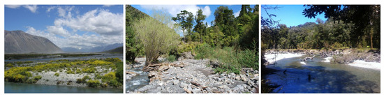
Figure 1.
Invasion of exotic vegetation in Aotearoa’s wild rivers—left: lupin, Rakaia River, foothills Southern Alps; middle: willow and buddleia, Tamaki River, headwaters Ruahine Ranges; contrasted with right: intact native forest in lower reaches of Smoothwater River, West Coast South Island. (Images by Ian Fuller).
Our paper is structured as follows. Following a historical overview of the socio-cultural and institutional relations to rivers in Aotearoa, we use examples from the Greater Wellington Region to appraise prospects to rewild rivers. We assess the associated policy implications in relation to the space to move interventions that have emerged elsewhere in the world in recent decades, showing how such perspectives align with key principles of mātauranga Māori, Māori knowledge—the body of knowledge originating from Māori ancestors, including the Māori world view and perspectives, Māori creativity and cultural practices.
2. Contextual Considerations. A Historical Overview of Changing Socio-Cultural Relations to Rivers in Aotearoa New Zealand
Toi tū te whenua, whatungarongaro te tangata—the land endures, while people come and go.
2.1. The New Zealand Landmass
New Zealand has a distinctive biophysical and socio-cultural history [26,27,28]. The long narrow landmass stretches 1500 km across 13 degrees of latitude (34–47° S, 166–178° E). Although most rivers are relatively short, steep and shallow, generally draining east/west from axial ranges, the country has a diverse suite of rivers for a landmass of its size. Marked differences are evident, for example, in the volcanic landscapes and deeply incised mudstones of the central North Island relative to the mountainous, glaciated landscapes and broad plains of the South Island.
2.2. Settlement History
Māori settlement of New Zealand commenced around 1300 AD. Early interactions with Europeans, from 1769 to the signing of the Treaty of Waitangi in 1840, entailed adjustments to the influences of missionary groups and early settlers, and associated agricultural developments and the expansion of trade [29]. Statistics NZ estimate that the population of New Zealand in 1840, when the Treaty of Waitangi was signed with the British Crown, was around 80,000 Māori and 2050 non-Māori. The present population of New Zealand (2021) is around 5.1 million, of whom 70% identify as New Zealand European, 16.5% are Māori, 15% are Asian and 8% are non-Māori Pacific Islanders (individuals were able to identify with more than one ethnic group in the 2018 census).
2.3. Māori Adaptations and Cosmology
In the centuries after initial Polynesian settlement in New Zealand and prior to European arrival, Māori language, cosmology and art forms adapted and morphed, new kinds of water craft and buildings were fashioned, and new fibre, stone and agricultural technologies were mastered [29]. Prior to European settlement, water use permission was collectively allocated by communities through custodial management systems, in which discrete kin groups controlled the use of particular waterways [19,30]. These permissions were established by whakapapa (ancestral relations), conquest and usage, but in some instances, they were highly contested [19]. Over generations, the relationship between particular kin groups and ancestral associations with their waters became increasingly interwoven with their identity as iwi (tribes) or hapū (subtribes) [19,21,31,32]. Rivers such as the Whanganui and the Waikato, for instance, were understood as ancestral beings, with their own life and power [11].
Water was considered as a taonga (ancestral treasure) due to its life-giving properties, importance in sustaining aquatic environments, as a food source (mahinga kai) [19] and its use in ritual, particularly spiritual cleansing [31]. Carefully prescribed codes of practice were applied to maintain sustainable levels of eels, lamprey, fish and other freshwater species. Designated places were put aside for activities such as ritual purification and washing. Keeping human waste out of waterways was of paramount importance. Restrictions were often placed on the use of water, including the use of rāhui or temporary restriction and tapu for more permanent bans. Direct hydrogeomorphic modifications to valley flats and river courses included local use of drainage ditches and irrigation practices [32,33].
In the ontologic of Māori language, people, land and ancestors are simply ‘the same thing’ [29]. Rivers are conceptualised as the lifeblood of the land, wherein the wellbeing of the river—encapsulated by its mauri (life force)—is intertwined with the wellbeing of its people [21,29]. For Māori, an awa (river) is not just a resource to be used. Rather, it is an interconnected, living system—a force to be lived with, reckoned with, and respected (te awa tupua) [34,35]. This reciprocal relationship innately frames manaaki whenua (caring for the land) alongside manaaki tangata (caring for people), wherein the mutual well-being of waterways, people and culture is enshrined through whakapapa [36,37]. Custodial linkages and responsibilities are expressed through kaitiakitanga (inter-generational guardianship). If interdependencies falter or fail, loss or destruction engenders a state known as mate (ill-health, dysfunction). Its contrary, ora, is a state of peace, prosperity and well-being for people, plants and animals, as well as the river [11,35].
2.4. Changing Relations following Colonisation
Colonial settlement brought about a marked change in societal relations to rivers in Aotearoa New Zealand from 1769 onwards. For the settlers, the value of rivers was measured mainly by their utility. In many ways, initial encounters with New Zealand rivers were troublesome, frustrating and disappointing, as aspirations for navigability and food resources were largely unfulfilled [7]. An early surveyor, Charles Hursthouse (1857) commented in his book entitled Britain of the South the following statement: ‘Just as New Zealand forests are destitute of game, so are its rivers destitute of fish’ [7], p. 90.
The Treaty of Waitangi/Te Tiriti o Waitangi is a written agreement signed in 1840 that established a partnership for British sovereignty and recognition of Māori rights and governance. This provided the basis for a collaborative partnership and engagement between Māori and the Crown (the Government). The treaty confers responsibilities and obligations on subsequent New Zealand governments to uphold rights for Māori as British subjects and New Zealand citizens, and to protect their land, estates, water, forests and other resources or treasures (taonga) [38]. A principle of redress asserts that the government is responsible for providing effective processes for the resolution of grievances in the expectation that reconciliation can occur [30,35].
In the first few years following the signing of the Treaty, Māori still occupied and used much of the land ‘sold’ to colonists. However, a significant influx of European immigrants, especially after the 1860s, brought about a progressive decline in Māori control of land and resources. Some land was ‘purchased’. Elsewhere, it was confiscated if tribes refused to sell it or it was stolen by the government. Some Māori bitterly referred to subdividing the land into smaller grids (blocks) as ‘cutting up the land’ [35]. Māori were not only alienated from many of their traditional lands and waters and taonga therein [19,21,35,36], and associated a loss of physical and spiritual connections with their awa (river), they were also excluded from the decision-making processes. Loss of mana severely impacted the Māori economy, way of life and identity, especially for those tribes who saw their rivers as ancestors—their tupuna [34].
For European settlers, utopian notions of progress and improvement led to wholesale clearance of native bushes, drainage of swamps and wetlands and the creation of large grassland areas for pastoral farming (often on steep, erodible hills as well as foothills and plains) [39,40]. Rivers were viewed as drains or sewers—conduits for the disposal of waste with a limitless capacity for self-cleansing and self-renewal, as inferred in the Public Works Act (1876; [7]). Mining had a catastrophic local impact on some rivers [41]. At this time, land could not be owned unless it was productively ‘worked’ (i.e., cleared and exploited for human benefit). Agriculture became the mainstay of the economy—initially sheep, but now dairy production.
Over time, a ‘command and control’ ethos sought to assert human authority over rivers [8,9]. Civil engineers were tasked to ‘harness the powers of nature for human benefit’, essentially ‘keeping rivers away from people’ [7]. This included piping of streams and rivers, emplacement of rock-lining for erosion control and stopbanks for flood control, and construction of dams for hydroelectricity schemes. Today, around 40 hydroelectric schemes with a capacity of >5000 MW, along with many smaller schemes, generate over half of the electricity needs of the country. Acclimatisation Societies introduced plant and animal species to make environments more familiar (i.e., more British) and at the same time, more productive and useful.
Early attempts to introduce legislation to address water pollution problems were recurrently thwarted by ‘wet industry’ lobby groups (meatworks, dairy factories, wool scours and piggeries) [7]. Despite the passage of the Rivers Board Act in 1884, attempts to ‘control’ floods prior to 1941 by channel straightening, confinement, and in-channel interventions were restricted, incomplete, and/or of such a low standard that attempts often failed. Knight [7] refers to an era of ‘stopbank wars’, in which landowners surreptitiously cut through built banks in the dead of the night to protect their own property.
The Soil Conservation and Rivers Control Act (1941) underpinned the movement towards total catchment management [7]. Extensive stopbank construction was often supplemented by rock-armouring, bank protection, dredging and clearance of obstruction, s such as vegetation (including willows, which had been planted historically in efforts to stem river-bed erosion). Straightening and diversion works (often known as cuts) were designed to speed up flood flows in certain reaches.
Subsequent amendments to the Local Government Act (1974) and the Water and Soil Conservation Act (1967) required regional plans to identify areas to be excluded from development because of natural hazards, such as flooding, unless adequate protection was provided [7], p187. Essentially, these various actions conceptualised rivers as ‘over there’—out of sight, out of mind [7,9]. However, this legislation brought about marked improvements in water quality. Tighter controls upon gross pollutants from industrial and urban sources brought about visible improvements in the clarity of many New Zealand’s rivers by the 1980s. Explicit recognition of the impacts of water extraction noted how reduced flows made rivers more susceptible to water quality degradation. Nevertheless, subsequent decades saw a substantial increase in irrigation abstractions, whether orchestrated through irrigation schemes funded by central-government or private irrigation developments.
2.5. Emergence of the Environmental Movement
Heightened awareness for the condition of rivers in Aotearoa New Zealand, and associated concerns to protect ‘what was left’ (Salmon [42]) underpinned growing environmental activism in the 1960s. Concerns for expansion of hydropower development at Lake Manapouri provoked enormous public outcry, which prompted the establishment of the ‘Guardians of the Lake’, considered to represent the birth of the environmental movement in New Zealand [43]. Aesthetic and recreational aspirations supported a growing tourism sector. Fish and Game New Zealand, an offspring of Acclimatisation Societies, sought to protect their hard work in establishing fisheries of exotic species through endeavours to limit pollution and restrict ‘development’ [7]. The Wildlife Service was established in 1974—the precursor to the Department of Conservation. In 1981, the Wild and Scenic Rivers Bill was passed into law as an amendment to the Water and Soil Conversation Act, protecting remaining ‘wild rivers’ from development [7].
Intensification of the dairy industry saw a tripling of the national dairy herd to 6.7 million from 1975–2014, while the number of sheep decreased from a high of 70 million in 1982 to less than 30 million in 2016 [7]. Increasing nutrient runoff from non-point source (diffuse) discharges has negatively impacted the chemical and ecological balance of rivers. Among numerous drivers, a ‘dirty dairying’ campaign instigated by Fish and Game in 2002 prompted the creation of the Dairying and Clean Streams Accord (Joy [24]). Despite recurrent rehabilitation initiatives, concerns for river health associated with the dairy boom continue to have a high media profile [7].
The Resource Management Act (RMA, 1991) was New Zealand’s first overarching environmental legislation that governed the use, development and protection of natural and physical resources was designed to enact proactive, forward-planning initiatives within a consent-based limit-setting framework. Regional councils, established in 1989, adopted different approaches to the implementation of the RMA. Accordingly, flood mitigation and water and soil conservation programs differed in different parts of the country. In general terms, however, rather than keeping rivers away from people, emphasis shifted to keeping people away from rivers [7], p. 188. Along with district and city councils, regional councils were empowered to restrict building and other land uses on land prone to flooding. A process of managed retreat embraced a broader conception of rivers, including the desire to preserve and protect them [7], p. 192. However, the neo-liberal market forces approach reinforced an exploitive utilitarian approach to support agricultural intensification and urban growth. Associated legal framings treat land and water as ‘property’, conceptualised as commodities for sale, regulating how much pollution or degradation of nature can occur within the law, giving no standing to nature itself or the associated non-human elements [29].
The Land and Water Forum (2009) brought together major stakeholders, including hydro-power generators, irrigators, Federated Farmers, Fonterra (New Zealand’s largest dairy company, Auckland, New Zealand), environmental NGOs and five major river iwi to negotiate agreed approaches to the management of freshwater in New Zealand. Debates over river health continued to emphasise acceptable levels of resource use and pollution in the neoliberal world of limit-setting and national standards [44,45]. The 2020 National Policy Statement for Freshwater (building on earlier iterations in 2011, 2014, 2017) directs regional councils to manage freshwater in an integrated and sustainable way. National bottom lines are set for two compulsory values, ecosystem health and human health for recreation, with minimum acceptable states identified for other national values. This forms part of a ‘national objectives framework’ in which bottom lines are set for selected water quality attributes, notably water chemistry, such as total phosphorus, nitrate toxicity and dissolved oxygen.
The National Policy Statement for Freshwater Management includes Te Mana o te Wai, explicitly recognising that protecting the health of freshwater protects the health and well-being of the wider environment [37]. Te Mana o te Wai is about restoring and preserving the balance between water bodies, the wider environment, and the community—protecting the mauri of the wai; the integrated and holistic well-being of a freshwater body [37]. This entails working with tāngata whenua and communities to set out long-term visions in regional policy statements and plans that prioritise the health and wellbeing of water bodies, then the essential needs of people, followed by other uses. Upholding Te Mana o te Wai acknowledges and protects the mauri of the water. This requires that the use of water also provides for Te Hauora o te Wai (health and mauri of the water body), Te Hauora o te Taiao (health and mauri of the environment), and Te Hauora o te Tāngata (the health and mauri of the people), including concerns for mahinga kai (gathering of food that is safe to eat), and protection of Wai Tapu (Sacred Waters). However, implementation is far from a straightforward process and contestations abound in this era of fluvial pluralism [11,21,32].
2.6. Māori as Rightsholders and Emerging Approaches to Co-Management
Despite the promise and prospect of the Treaty of Waitangi (1840), it is only in recent decades that Māori have had a genuine capacity to shape environmental and river management policy and practices in New Zealand [30,38,46,47,48]. In direct contravention of the terms of the Treaty, many statutes relating to land and water management, such as the Water Power Act (1903) and the Water and Soil Conservation Act (1967), affirmed the position of the Crown as having the sole right to use, dam, divert and discharge water. The Town and Country Planning Acts of 1926 and 1953 both concluded that Māori planning was outside the realm of mainstream planning and did not have to specially provide for Māori participation in statutory planning [30,46]. Indeed, the Town and Country Planning Act (1977) was the first statute since 1840 that acknowledged the relationship of Māori and the environment. Despite these moves, consultation processes around the formulation of the Wild and Scenic Rivers legislation, which was enacted in 1981 as an amendment to the Water and Soil Conservation Act, emphasized aesthetic and recreational values, retaining an anthropocentric focus, with limited regard for ecological, intrinsic or cultural values in protecting open spaces for present and future New Zealanders [7], pp. 196–197. The Māori voice was almost entirely absent from such deliberations, yet these moves indirectly resulted in more restraints upon the last vestiges of Māori mana/authority of their ancestral rivers.
In part, the transitional process of Māori reengagement with environmental management policies has been driven by a failure to apply the terms of the Treaty of Waitangi. A myriad of claims, related largely to land and water, have been contested, and many have already been addressed, through the Waitangi Tribunal (established under the Treaty of Waitangi Act, 1975). This seeks redress for historic actions, grievances, and omissions by the Crown that breach treaty promises by the Crown, including claims relating to the loss and/or degradation of ancestral rivers, lakes, springs, wetlands, estuaries, and other waterways. A number of treaty settlements reported via the Tribunal have offered a formal apology, as well as economic and cultural redress [48]. The Waitangi Tribunal has articulated a number of resource-specific principles, including those that state that the spiritual and cultural significance of a freshwater resource can only be determined by tāngata whenua and their traditional rights [38,48].
Recent evolution in the regulatory framework, market dynamics and social contract in New Zealand is prompting movement towards more collaborative, integrative, systems-based approaches to managing water [11,47,48]. Profound transitions in relationships between the government and broader society have accompanied emerging approaches to environmentalism. Increasingly, governments devolve environmental management to the ‘people’, as the central government adopts an increasingly hands-off approach. Experimental approaches to participatory governance became de rigueur in this era of self-regulation, driven by market forces [49]. Emerging approaches to land and water management in Aotearoa New Zealand are resoundingly clear on one key premise that there is no future that does not involve everyone in some way in maintaining healthy waterways. Increasingly, resource management is framed as a shared responsibility between the government and iwi/hapū. Every statutory document requires consultation and participation with Māori, and local authorities are required to take reasonable steps to carry out the following:
- Actively involve tāngata whenua in the management of fresh water and freshwater ecosystems (including decision-making processes);
- Work with iwi and hapū to identify and provide for tāngata whenua values and interests in fresh water and freshwater ecosystems;
- Reflect tāngata whenua values and interests in the management of, and decision-making regarding fresh water and freshwater ecosystems.
Various approaches to co-governance, co-management and co-planning have emerged over the past 20 years [19,49,50,51,52]. The ability of local iwi and hapū to exercise rangatiratanga (chieftainship, right to exercise authority) is pivotal to these arrangements [38], enhancing prospects that a river is able to speak for itself [39].
2.7. Historical Underpinnings of Contemporary Socio-Cultural Relations to Rivers in Aotearoa
Although freshwater is abundant in Aotearoa New Zealand, its management continues to be contentious, with concerns for both the quantity and quality of available resources. Perceptions of healthy rivers have changed significantly over time [44]. Historically, industrial systems of forestry, fishing and farming largely ignored the rich variety of landscapes and ecosystems. Catastrophic losses in biodiversity ensued, as waterways and harbours became choked with sediment, pollutants and contaminants, and aquifers and waterways were depleted beyond sustainable limits [53].
Ongoing pressure upon available water resources—for agricultural uses and a growing irrigation sector, for the power generation and industry, and for domestic consumption in rapidly growing urban areas—is increasingly framed alongside concerns for spiritual, environmental, aesthetic and recreational values. Prospects to re-wild rivers must be conceived and enacted in light of these considerations.
3. Taming Wild Rivers in the Greater Wellington Region
“Things separate from their story have no meaning. When their story has been lost to us they no longer have a name. The story on the other hand can never be lost from its place in the world for it is that place.”Cormac McCarthy, The Crossing (1994, pp. 142–143)
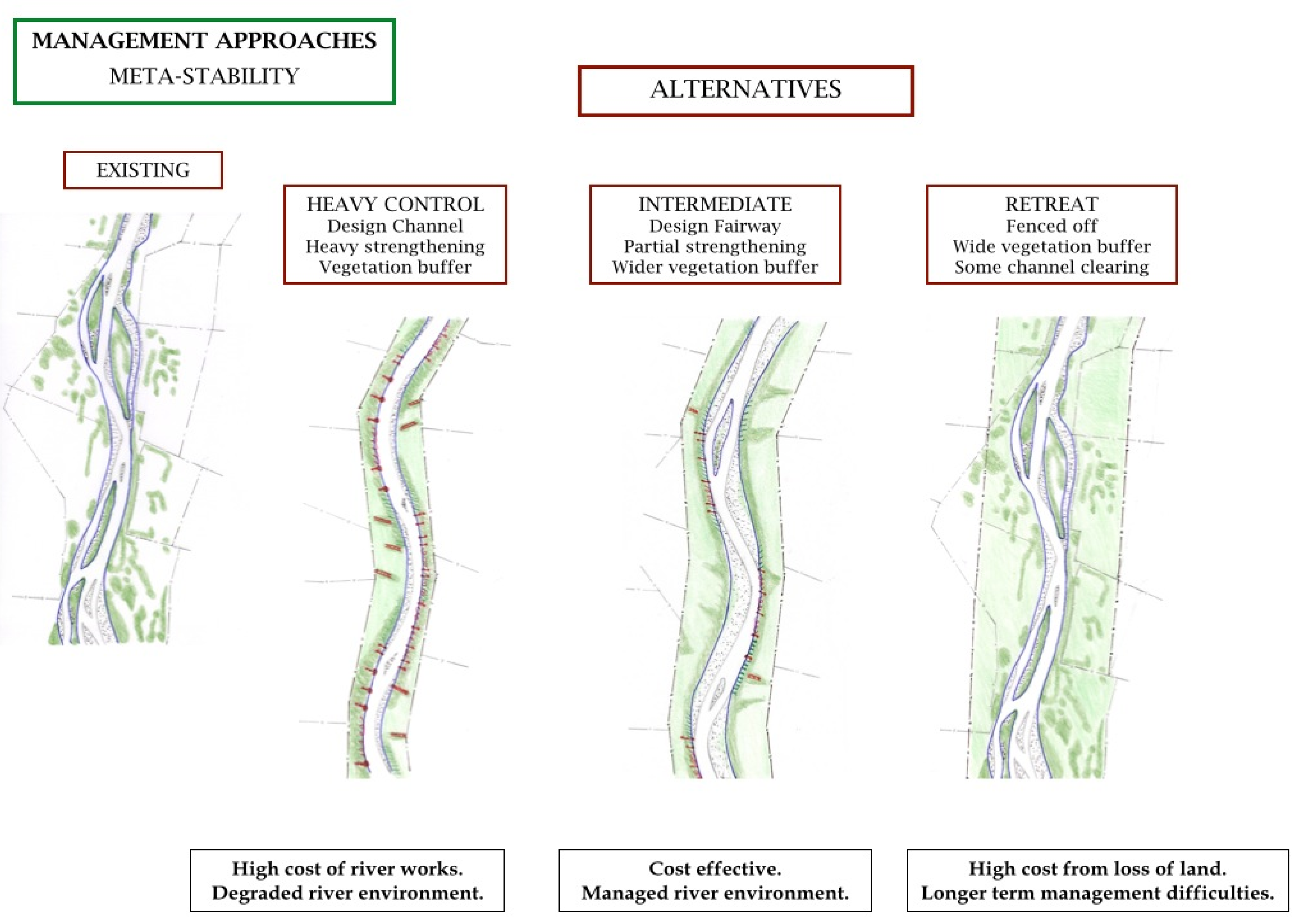
Many difficult decisions had to be made in the era of command-and-control river management following the Second World War. The dynamic gravel-bed nature of many river systems presented significant challenges in addressing utilitarian concerns for flood hazards on the one hand, and prospects to develop flat, accessible, well-watered floodplain lands on the other. Figure 2 conceptualises the options or choices in these deliberations. The conventional heavy control approach fixed the channel edge, essentially pinning the channel in place [54,55,56]. Conversely, the retreat approach provides a wide river corridor that maximises scope for river activity. However, if this area becomes densely vegetated by introduced species (willows, gorse, broom, tree lucerne, lupin and other invasive pioneers, cf. Figure 1), recurrent vegetation control is required as flood flows are choked and breakouts may occur. Essentially, the intermediate approach is a compromise between societal needs for the flat lands adjacent to the channel and associated flood risk/hazard mitigation, and the space needs of the river itself, in terms of its use of energy, alongside potential problems of exotic vegetation incursions if the river is given too much space. The design channel areas and vegetation buffers do not have fixed boundaries (i.e., they are adjustable). A vegetation buffer zone creates a diffuse and flexible boundary that assists in the containment of river activity. However, the active channel, vegetation buffer zones and reserve areas create a defined river corridor, setting aside this area of clear gravel bars and islands for the river to rework bed/bank materials (i.e., the dynamic physical habitat mosaic). Clearance of riparian vegetation in the fairway itself restricts flow roughness/resistance. If the reach conditions change significantly, in response to factors such as a change in flood intensity, a pulse of bed material, or spread of vegetation across the active channel area, the design channel area and management approach may be adapted. Dense vegetation margins at the outer boundary of the river corridor maintain a more fixed boundary that separates the assets and activities of people from the habitats and activities of the channel(s), buffering and absorbing the impacts of channel migration.
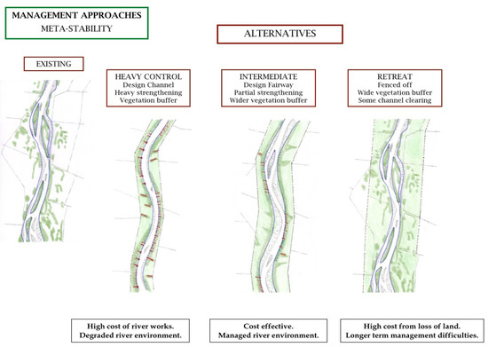
Figure 2.
Management options for riparian corridors conceived through a command-and-control lens [55]. See text for details.
Any design is a management guideline for the conditions of a particular time and place. The active channel area defined for a given reach was based on the river type and the nature and rate of channel changes over time. The design is based on contemporary channel conditions and alignment (decadal averages of the dynamics of channel movement), rather than an ancestral or historical condition. This was determined by analysis of river survey data and repeat aerial photography, along with early survey plans of river beds.
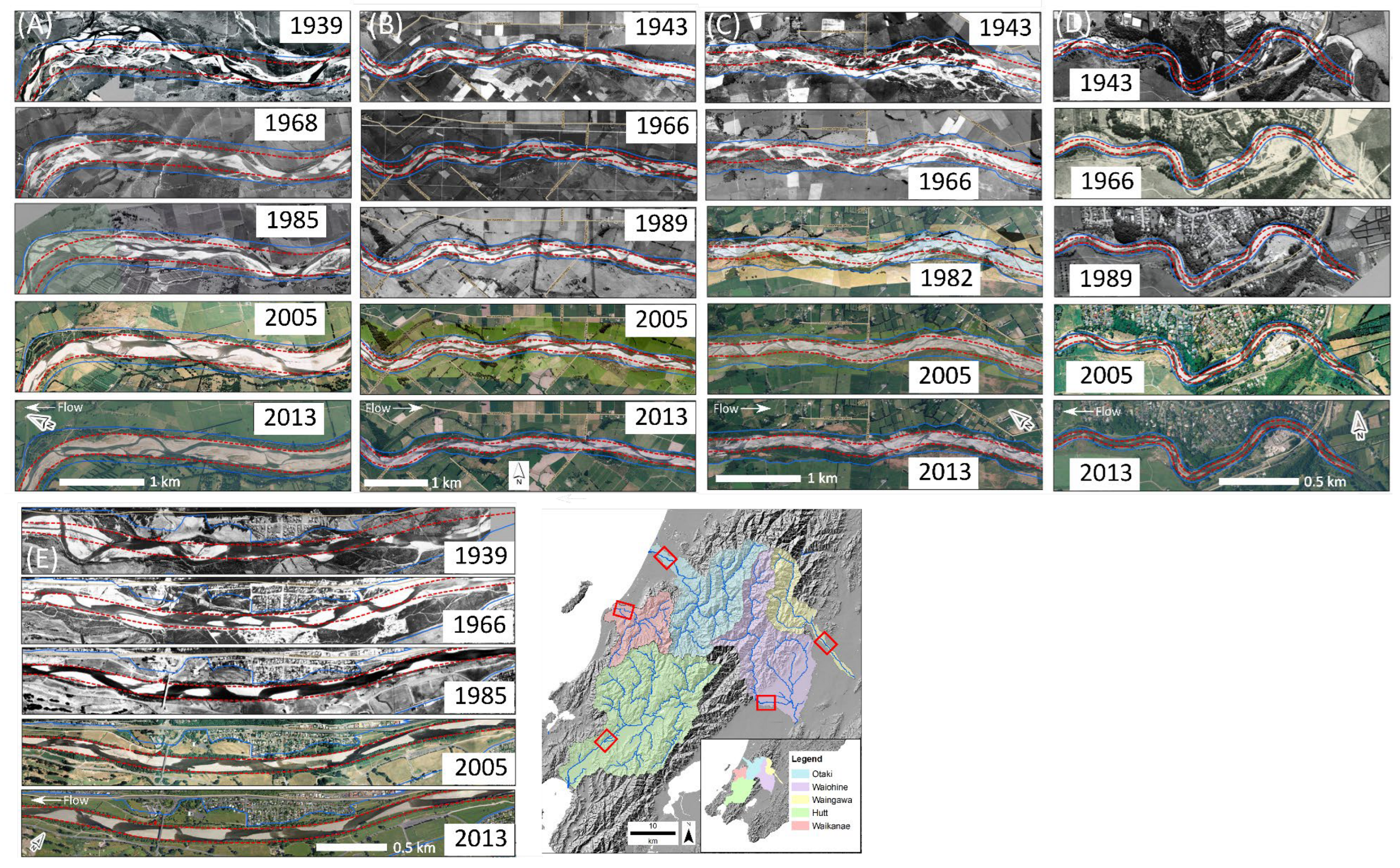
Command-and-control management practices greatly simplified and homogenized rivers in the Greater Wellington Region, bringing about significant changes to their functionality and biodiversity values (Figure 3 and Figure 4). Headwater areas of all primary rivers in this region lie in the Tararua Range (around 1500 m asl; Figure 3). Short, steep upper catchments flow to relatively narrow coastal plains, where high energy lower reaches, have been intensively managed (Figure 4 and Figure 5). Engineering practices tamed the capacity for adjustment and range of variability in these rivers. Profound environmental and socio-cultural loss (solastalgia) accompanied the creation of different forms of living entities [25].
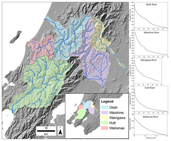
Figure 3.
Bed elevation profiles for selected Greater Wellington Region catchments: Ōtaki, Waiohine, Waingawa, Hutt, Waikanae.
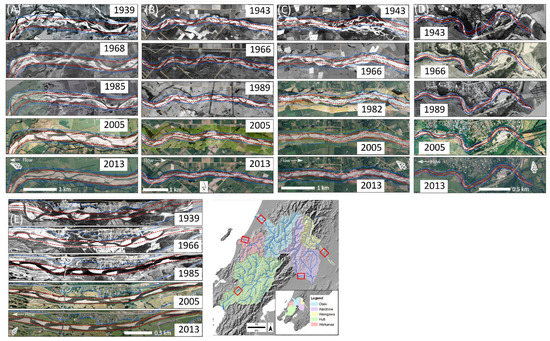
Figure 4.
River channel changes from ca.1940s to 2010s, Greater Wellington Region: (A) Ōtaki, (B) Waiohine, (C) Waingawa, (D) Waikanae, (E) Hutt, showing channel rationalisation, simplification, narrowing and straightening impacts of river management under a ‘control’ ethos. Locations of reaches shown using boxes in inset. Red lines are the river design channel alignment, blue lines delineate river corridor boundary. All images were provided courtesy of Phil Cook, Greater Wellington Regional Council.
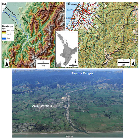
Figure 5.
(A) Ōtaki catchment terrain and location on the North Island of New Zealand (inset); (B) topographic map showing the intensively developed coastal strip, while forest cover remains across much of the catchment—the red dashed box indicates the lower river area of interest in this study; (C) oblique aerial image looking upstream across the narrow coastal plain to the Tararua Ranges.
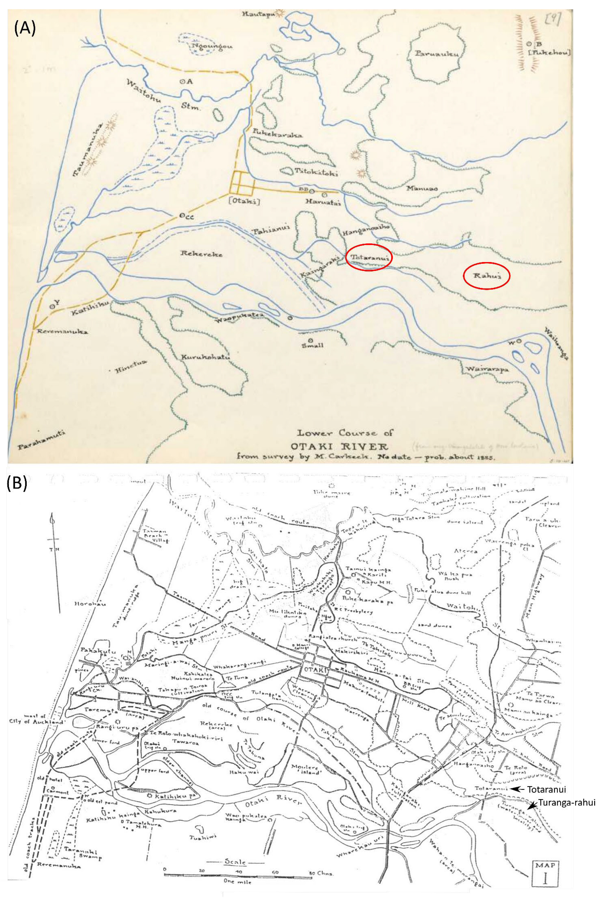
As noted in the quote by McCarthy (1994) at the beginning of this section, naming landforms and the stories that underpin them reflect particular meanings and connections to place [57]. In the late nineteenth and early twentieth centuries, ancestral Māori connections inscribed distinctive meaning to landforms along the Ōtaki River (Figure 6). Distinctive biophysical values included complex assemblages of braided channels and associated freshwater-terrestrial ecosystems, with swamplands, ponds, aquatic and floodplain features, abandoned channels, lagoons, dunes, and a range of features at the marine interface. Socio-cultural relations to the river reflected and built upon this diversity, with differing uses and connections to different components of the river (Figure 6). In this sense, the map has no blank spaces, as all parts of landscapes are inscribed with meaning [58]. Importantly for Māori, the entire river system, Mai i ngā Maunga ki te Moana ‘From the Mountains to the Sea’, was conceived as a living, indivisible entity [22]. Such considerations were ignored and pushed aside, as engineering interventions constrained the lower course of the Ōtaki River (Figure 4, Figure 5 and Figure 7). Fragmentation of the system disrupted ancestral relations and connections, and the ora, mana and mauri of the river. Transcripts of oral records document the sense of loss [59].

Figure 6.
(A) Earliest available map of lower Ōtaki River, ca. 1885, high-resolution image available online [60]; (B) Ōtaki River, ca. 1930 [5]. Prior to European occupation in the later 1800s, much of the coastal plain was covered in forest, other than river corridors and wetlands. The area clear of forest labelled Rahui and circled in (A) was a subsidiary branch of a large anabranch of the Ōtaki named Turanga-rahui (B, arrow). Totaranui (circled, (A); arrow, (B), is described as a rich alluvial floodplain intersected by deep and normally sluggish watercourses [61]. Former channels are clearly visible in a LiDAR-derived DEM (Figure 7).
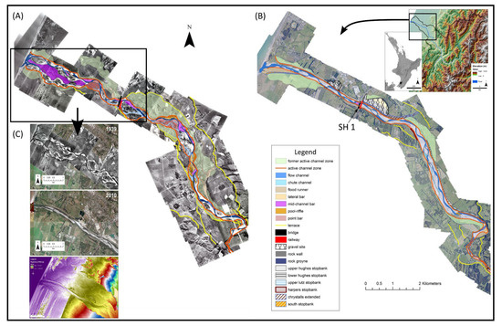
Figure 7.
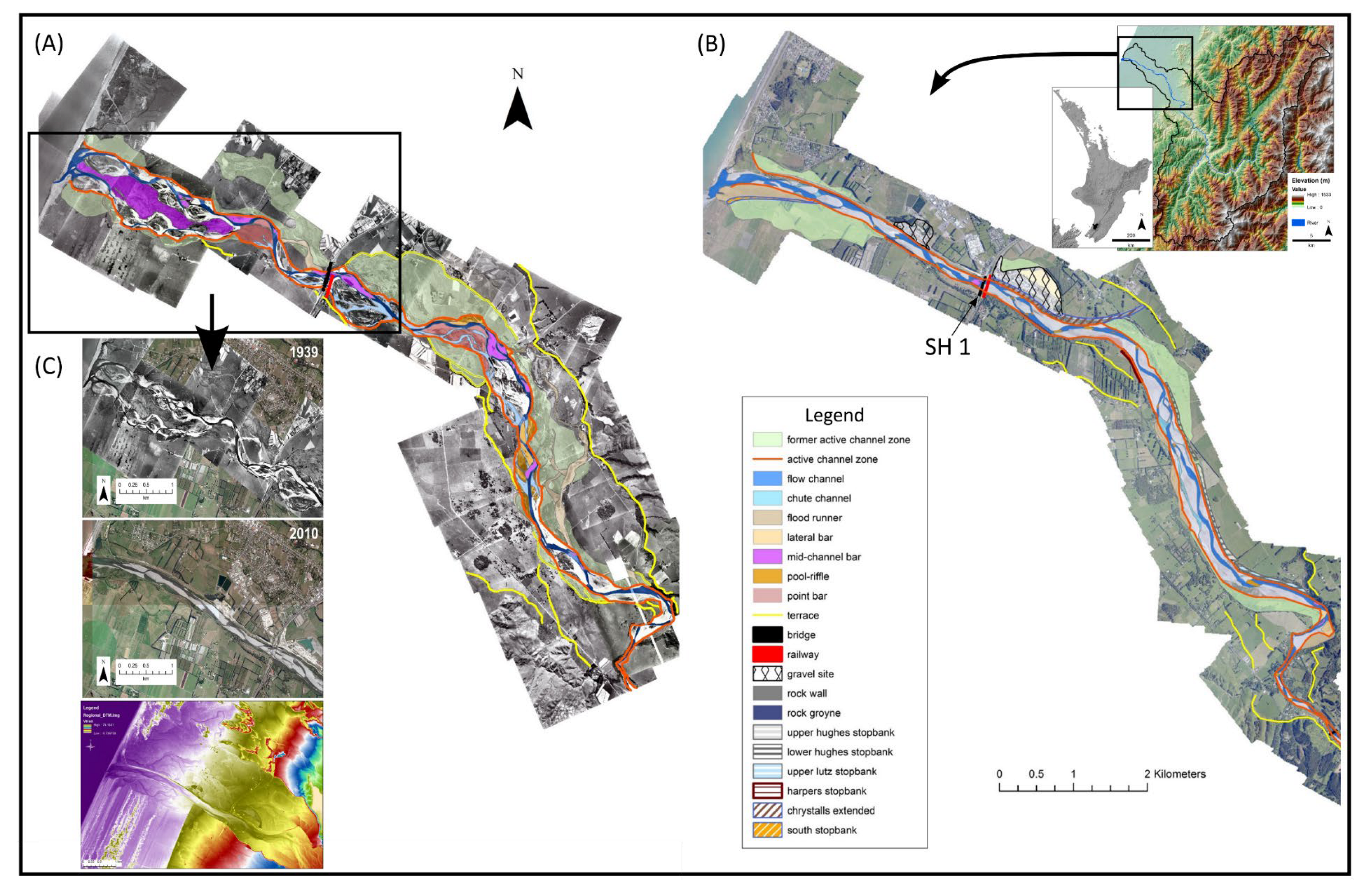
(A) River geomorphology in 1939 prior to engineering; (B) modified geomorphology and engineering structures in 2016; (C) earliest available aerial imagery of lower Ōtaki River (1939), compared with the modified river in 2010 and a LiDAR-derived digital elevation model (DEM). The DEM shows the extent of the Ōtaki floodplain inset between higher alluvial surfaces (east), coastal dunes (west and north) and former beach ridges (west and south). The diversity of the pre-engineered river in 1939 is clear. The rich mosaic of geomorphic units (multiple wet and dry channels, anabranches, gravel bars, vegetated bars) presents a stark contrast to the uniformity and dominance of human structures in the engineered river. The permitted floodplain has been narrowed by up to 90% and the active channel by around 50% [62]. Crossing of State Highway 1 (SH1) referred to in text is labelled in (B), central legend applies to (A,B).
Between 1945 and 1955, stopbank construction and bank protection along the lower course of the Ōtaki River created valuable land on previously connected floodplain surfaces that facilitated urban and agricultural development (Figure 5, Figure 6, Figure 7 and Figure 8). The lower reach below the State Highway (SH1) Bridge has been straightened and confined by stopbanks. A large tower dredge that came from the United States created the straight channel alignment from the bridge to the sea. The stopbanks were formed as piles of river gravel pulled out by the dredge. The design channel left little space for buffer vegetation. Recurrent additions and extensions of rock-work linings have occurred over time.
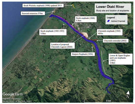
Figure 8.
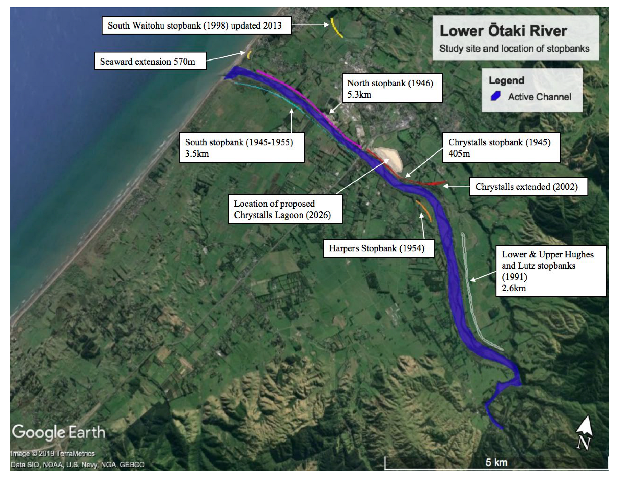
Stopbanks along the lower course of the Ōtaki River.
In 1939, the channels were recurrently adjusted to variable flow/sediment inputs as the river had ample room to move. By 2016, however, the lower Ōtaki was heavily controlled, essentially operating as a single channel between stopbanks (cf. Figure 7 and Figure 8). A prominent river bend (Chrystalls), where the river crosses a fault line, became increasingly tight over time due to continual reinforcing of the outer bank of the bend (Figure 8). Subsequent channel diversion realigned the bend along a smoother track, further straightening the channel.
Upstream of the Chrystalls Bend, the stopbank has been set back to widen a narrow reach of the river (Figure 8). The wider fairway above SH1 allows some channel adjustment in the upper part of the coastal plains reach. Substantial buffer zones allow an effective use of vegetation as a soft margin. As the coarse bed material and intense short duration floods create and rework complex channel forms in the fairway, channel re-shaping and re-alignments is required to maintain a favourable channel alignment. Intense channel works have reduced the erosion risk to the areas adjacent to Late Pleistocene high terrace cliffs on the true left of the channel (cf. Figure 7C).
Historical circumstances set the scene for future prospects, including efforts to reanimate and rewild rivers in Aotearoa. Past straightening and confinement efforts continue to present problems in the lower reach below SH 1. While an alternating main channel continues to form around gravel bars (Figure 7), there is insufficient space for appropriate buffers or for any channel widening in large flood events in the current management regime, which emphasises control. A form of socio-ecological and institutional memory is being played out, as the original dredging has necessitated the recurrent application of a heavy control approach. Programmed works in the Ōtaki alone cost over NZD 5 million in 1997, not including subsequent construction and maintenance costs.
4. Discussion: Implications for Prospective River Futures
Taming Aotearoa’s wild rivers has generated dysfunctional river corridors, which are not fit for purpose [8,9]. Despite good intentions, intermediate control measures have disconnected rivers from society in many lower reaches, corralling them behind stopbanks (Figure 2). Costly and regular intervention is required to keep the river ‘trained’ in a preferred alignment, while accommodating some room to move within the permitted river corridor. Significant loss of riparian habitat and diversity has ensued and these changes have been quantified elsewhere [63]. Rivers that are locked in space, fixed in time [64], are expensive to maintain [65].
Critically, though, the tamed rivers of Aotearoa New Zealand remain wild at heart. They continue to pose a significant risk to society, both in terms of financial costs resulting from damage and potential cost in life and livelihood. The training of wild rivers has its limit, and once floods exceed those limits, large-scale destruction occurs [8,9]. The shift in storm intensity with a warmer atmosphere and oceans will exacerbate hazards in the future [66]. Arguably, whenever possible and practicable, it is better to release Aotearoa’s ‘strangled rivers’ in a measured, controlled way, before they release themselves, with catastrophic consequences to life and infrastructure [8,9].
River management in Aotearoa New Zealand is at a cross-roads, as emerging approaches to co-management and co-governance reconceptualise socio-cultural relations to rivers. In contrast to a defensive mindset that pits society against natural river processes and functions, a relational mindset underpins a conscious decision to recognise and respect the ‘rights of the river’—allowing a river to be a river [10,18,37].
However, transformations in approaches to river management in Aotearoa are far from straightforward and uncontested. Recent policy shifts have resulted in a clash of framings, as Māori are forced to relate and apply language based on possessive individualism (property, ownership and rights) to speak about their relations with ancestral water bodies. Utilitarian notions of resources as ‘commodities’ foster the illusion that they can be used without limit for human purposes [29]. If Māori claimants wish to uphold their relations with ancestral waterways, they must acquiesce in redefining these relations as property interests ‘for the purposes of the law’—a kind of ontological submission [29,35]. Contestations over such ‘alternative realities’ [35] position Māori merely as a stakeholder in such deliberations, yet as treaty partners with the Crown, Māori interests should be expressed as ‘rights-holders’.
As legacy effects and path dependencies induced by past management actions constrain future options, inhibiting prospects for regenerative practices, and requiring ongoing, increasingly expensive maintenance costs, they have significant implications for social and environmental justice and intergenerational equity [67]. In some instances, recurrent tinkering or extension of stopbanks is required, especially if the bed of the channel aggrades [9]. In situations where a hands-off approach promotes widening of river corridors (Figure 2), the choking of channels by invasive exotic vegetation requires recurrent river training to facilitate sediment and channel mobility (cf. Figure 1). Increasingly sophisticated guidance is in-hand to support such determinations (e.g., [68]).
Such issues parallel comments by Laing [69], p. 177, in her reflections upon the ‘annoyances and defects’ of the recurrent costs of repairs associated with the ‘imprisonment’ of the lower Ouse River in Sussex, England. She elegantly conceptualises landscapes as ‘palimpsests laid down in layers … (wherein) some eras work in pencil and others in indelible ink … (such that while) its previous character may be discernible … it cannot be retrieved’. Laing also states the following: “(A)ll actions store up consequences” [69], p178, and in some instances, it is not possible to retrieve past values and/or connections. Laing [69], p. 178 characterises the propensity to repeat injustices and inequities of past practices in relation to “The wrongheaded rapaciousness of my own species, carving the world up with no thought to its consequences: behaviour, ironically enough, that seems doomed to bring an apocalypse of floods and droughts upon us all”? Recognising that recurrent tinkering merely delays the inevitable, as strain builds up over time, it pays to openly negotiate prospects to relinquish land to the river, rather than waiting for the river to reclaim its own land [64].
As of yet, meanings of these riverscapes and coevolutionary relationships with tangata whenua are inappropriately acknowledged in policy framings. Intriguing and compelling challenges lie ahead in the efforts to address this impasse. To the authors of this paper, this entails working constructively at the interface of Mātauranga Māori and western science and engineering, seeking ways to redress a pervasive sense of loss through collective endeavours to enhance the ora of the awa of Aotearoa.
While wholesale rewilding is not possible, given the needs for asset and infrastructure protection and associated path dependencies, a moratorium could be placed on new developments that further encroach on the active channel bed and floodplains. Work in Canada [70,71] and Europe [72,73] already demonstrates the utility and economic benefit of giving more room to the river, as well as the ecological enhancement and geomorphic diversity this brings [74,75]. Whilst it may be unrealistic to completely re-naturalise entire floodplains, economic, environmental, and socio-cultural gains can be made in better accommodating a greater range of river processes and habitats for ‘wild’ river corridors. Indeed, returning low-lying floodplain areas to the river is required to regenerate native lowland forests that thrive on permanently wet floodplains.
Anthropogenic assertions of dominance over nature in the river management arena have been echoed in intensive approaches to industrial agricultural practices in Aotearoa New Zealand, with their dependence upon high energy and high chemical use. There is little prospect to avoid an impending crisis, unless sustainable approaches to agriculture production are incorporated within integrated water resource management plans [76]. As of yet, limited uptake of regenerative approaches to rewilding rivers parallels few (but important) small-scale approaches to regenerative agriculture—practices that work with nature, rather than against it.
Prospectively, revisions to the current Resource Management Act (RMA) could facilitate a transformation in practice. However, implementation at a devolved local scale remains problematic. Regional Councils lack resources, so appropriate funding must accompany new legislation if it is to be effective. To enlarge river corridors via managed retreat will require selective buy-back of agricultural land that has been farmed for several decades, and relocation of vulnerable properties in urban, suburban and rural areas. Inevitably, such changes have significant, as of yet unquantified, costs. Planning for the future in times of extreme uncertainty recognises that extensive assets are at risk and adaptive and mitigative solutions will become even more expensive in the future [66].
5. Concluding Comment
In response to the provocative question posed by Wohl [77], “at what point in the downward spiral of river engineering, damage from natural hazards such as floods, and loss of ecosystem services do we completely re-envision possibilities …?”, we believe that the process of re-imagining the wild rivers of Aotearoa is already happening. Recognising that the status quo is not fit for purpose from an economic perspective, particularly given the prospect of increasing flood frequency and magnitude in a warming climate, adaptation and proactive planning are already underway. Although re-wilding may not be realistic, accommodating some wild behaviour is at least part of the imaginary in scoping river futures. Enlarging permitted river corridors to allow rivers to adjust their form to a likely increasing magnitude of floods in the coming decades envisages interventions that work with rivers as living, dynamic entities. In turn, this strategy re-connects socio-cultural and ancestral connections to rivers.
Author Contributions
Conceptualization, G.B. and I.F.; investigation, G.B., I.F., G.W., D.H. and A.T.; resources, A.T., G.B., I.F. and G.W.; writing—original draft preparation, G.B., I.F., G.W., D.H., A.T.; writing—review and editing, G.B., I.F., G.W., D.H. and A.T.; visualization, I.F., A.T., G.B. and G.W. All authors have read and agreed to the published version of the manuscript.
Funding
G.B. and D.H. acknowledge support from the Marsden-funded project ‘Let the Rivers Speak’.
Acknowledgments
We thank Horacio Garcia for initiating our involvement in this Special Issue. Amanda Death provided helpful comments on an earlier draft of this paper. A.T. thanks those who supported the completion of her BSc Honours dissertation in the School of Environment at Auckland University, which examined the character and behaviour of the Ōtaki River prior to stopbank development. The authors thank the three reviewers and the editor for their helpful suggestions that helped to restructure and tighten this paper.
Conflicts of Interest
The authors declare no conflict of interest.
References
- Piégay, H.; Cottet, M.; Lamouroux, N. Innovative approaches in river management and restoration. River Res. Appl. 2020, 36, 875–879. [Google Scholar] [CrossRef]
- Wohl, E. Wilderness is dead: Whither critical zone studies and geomorphology in the Anthropocene? Anthropocene 2013, 2, 4–15. [Google Scholar] [CrossRef]
- Montgomery, D.R. Dreams of Natural Streams. Science 2008, 319, 291–292. [Google Scholar] [CrossRef] [PubMed]
- Royer, T.V. Chapter 12—Human-Dominated Rivers and River Management in the Anthropocene. In Stream Ecosystems in a Changing Environment; Jones, J.B., Stanley, E.H., Eds.; Academic Press: Boston, MA, USA, 2016; pp. 491–524. [Google Scholar]
- Fuller, I.C.; Macklin, M.G.; Richardson, J.M. The Geography of the Anthropocene in New Zealand: Differential River Catchment Response to Human Impact. Geogr. Res. 2015, 53, 255–269. [Google Scholar] [CrossRef]
- Beattie, J.; Morgan, R. Engineering Edens on This’ Rivered Earth’? A Review Article on Water Management and Hydro-Resilience in the British Empire, 1860–1940s. Environ. Hist. 2017, 23, 39–63. [Google Scholar] [CrossRef]
- Knight, C. New Zealand’s Rivers: An Environmental History; Canterbury University Press Christchurch: Auckland, New Zealand, 2016. [Google Scholar]
- Brierley, G.; Hikuroa, D.; Friedrich, H.; Fuller, I.; Brasington, J.; Hoyle, J.; Tunnicliffe, J.; Allen, K. Why We Should Release New Zealand’s Strangled Rivers to Lessen the Impacts of Future Floods. The Conversation, 22 February 2021. Available online: https://theconversation.com/why-we-should-release-new-zealands-strangled-rivers-to-lessen-the-impact-of-future-floods-153077# (accessed on 6 March 2022).
- Brierley, G.; Hikuroa, D.C.H.; Fuller, I.C.; Tunnicliffe, J.; Allen, K.; Brasington, J.; Friedrich, H.; Hoyle, J.; Measures, R. Reanimating the strangled rivers of Aotearoa New Zealand. Wiley Interdiscip. Rev. Water, 2022; in press. [Google Scholar]
- Brierley, G.; Tadaki, M.; Hikuroa, D.; Blue, B.; Šunde, C.; Tunnicliffe, J.; Salmond, A. A geomorphic perspective on the rights of the river in Aotearoa New Zealand. River Res. Appl. 2019, 35, 1640–1651. [Google Scholar] [CrossRef]
- Hikuroa, D.; Brierley, G.; Tadaki, M.; Blue, B.; Salmond, A. Restoring Sociocultural Relationships with Rivers. In River Restoration: Political Social and Economic Perspectives; John Wiley & Sons: New York, NY, USA, 2021; pp. 66–88. [Google Scholar] [CrossRef]
- Wantzen, K.M.; Ballouche, A.; Longuet, I.; Bao, I.; Bocoum, H.; Cissé, L.; Chauhan, M.; Girard, P.; Gopal, B.; Kane, A.; et al. River Culture: An eco-social approach to mitigate the biological and cultural diversity crisis in riverscapes. Ecohydrol. Hydrobiol. 2016, 16, 7–18. [Google Scholar] [CrossRef]
- Ruru, J. Listening to Papatūānuku: A call to reform water law. J. R. Soc. N. Z. 2018, 48, 215–224. [Google Scholar] [CrossRef]
- Brierley, G.J.; Fryirs, K.A. River Futures: An Integrative Scientific Approach to River Repair; Cambridge University Press: Cambridge, UK, 2008. [Google Scholar]
- Dufour, S.; Piégay, H. From the myth of a lost paradise to targeted river restoration: Forget natural references and focus on human benefits. River Res. Appl. 2009, 25, 568–581. [Google Scholar] [CrossRef]
- Kopf, R.K.; Finlayson, C.M.; Humphries, P.; Sims, N.C.; Hladyz, S. Anthropocene Baselines: Assessing Change and Managing Biodiversity in Human-Dominated Aquatic Ecosystems. Bioscience 2015, 65, 798–811. [Google Scholar] [CrossRef] [Green Version]
- Pauly, D. Anecdotes and the shifting baseline syndrome of fisheries. Trends Ecol. Evol. 2019, 10, 430. [Google Scholar] [CrossRef]
- Brierley, G.J. Finding the Voice of the River: Beyond Restoration and Management; Springer Nature: London, UK, 2020; p. 179. [Google Scholar]
- Harmsworth, G.R.; Awatere, S. Indigenous Māori Knowledge and Perspectives of Ecosystems. Ecosystem Services in New Zealand—Conditions and Trends; Manaaki Whenua Press: Lincoln, New Zealand, 2013; pp. 274–286. [Google Scholar]
- McAllister, T.G.; Beggs, J.R.; Ogilvie, S.; Kirikiri, R.; Black, A.; Wehi, P.M. Kua takoto te mānuka: Mātauranga Māori in New Zealand ecology. N. Z. J. Ecol. 2019, 43, 1–7. [Google Scholar] [CrossRef]
- Stewart-Harawira, M.W. Troubled waters: Maori values and ethics for freshwater management and New Zealand’s fresh water crisis. Wiley Interdiscip. Rev. Water 2020, 7, e1464. [Google Scholar] [CrossRef]
- Wilkinson, C.; Hikuroa, D.C.H.; Macfarlane, A.H.; Hughes, M.W. Mātauranga Māori in geomorphology: Existing frameworks, case studies, and recommendations for incorporating Indigenous knowledge in Earth science. Earth Surf. Dynam. 2020, 8, 595–618. [Google Scholar] [CrossRef]
- Joy, M.; Canning, A. Shifting baselines and political expediency in New Zealand’s freshwater management. Mar. Freshw. Res. 2020, 72, 456–461. [Google Scholar] [CrossRef]
- Joy, M. Vested Interests in Big Agriculture: A freshwater scientist’s personal experience. Policy Q. 2021, 17, 51–55. [Google Scholar] [CrossRef]
- Albrecht, G.; Sartore, G.-M.; Connor, L.; Higginbotham, N.; Freeman, S.; Kelly, B.; Stain, H.; Tonna, A.; Pollard, G. Solastalgia: The distress caused by environmental change. Australas. Psychiatry 2007, 15, S95–S98. [Google Scholar] [CrossRef]
- Anderson, A.; Binney, J.; Harris, A. Tangata Whenua: An Illustrated History; Bridget Williams Books: Wellington, New Zealand, 2014. [Google Scholar]
- Gibbs, G.W. Ghosts of Gondwana: The History of Life in New Zealand; Craig Potton Publishing: Nelson, New Zealand, 2006. [Google Scholar]
- King, M. The Penguin History of New Zealand; Penguin Random House New Zealand Limited: Auckland, New Zealand, 2003. [Google Scholar]
- Salmond, A. Tears of Rangi: Experiments Across Worlds; Auckland University Press: Auckland, New Zealand, 2017. [Google Scholar]
- Memon, P.A.; Kirk, N. Role of indigenous Māori people in collaborative water governance in Aotearoa/New Zealand. J. Environ. Plan. Manag. 2012, 55, 941–959. [Google Scholar] [CrossRef]
- Williams, J. Resource management and Māori attitudes to water in southern New Zealand. N. Z. Geogr. 2006, 62, 73–80. [Google Scholar] [CrossRef]
- Phillips, C. Waihou Journeys: The Archaeology of 400 Years of Maori Settlement; Auckland University Press: Auckland, New Zealand, 2013. [Google Scholar]
- Tribunal, N.Z.W. Muriwhenua Land Report (Wai 45); GP Publications: Wellington, New Zealand, 1997. [Google Scholar]
- Muru-Lanning, M. Tupuna Awa: People and Politics of the Waikato River; Auckland University Press: Auckland, New Zealand, 2016. [Google Scholar]
- Salmond, A. Tears of Rangi: Water, power, and people in New Zealand. HAU J. Ethnogr. Theory 2014, 4, 285–309. [Google Scholar] [CrossRef]
- Ngata, T.; Kim, N.; Hammond, V.; Dewes, A.; Tapsell, P.; Fraser, P.; Foote, K.; Knight, C.; Carden, S.; McKenzie, P. Mountains to Sea: Solving New Zealand’s Freshwater Crisis; Bridget Williams Books: Wellington, New Zealand, 2018; Volume 71. [Google Scholar]
- Te Aho, L. Te Mana o te Wai: An indigenous perspective on rivers and river management. River Res. Appl. 2019, 35, 1615–1621. [Google Scholar] [CrossRef]
- Harmsworth, G.; Awatere, S.; Robb, M. Indigenous Māori values and perspectives to inform freshwater management in Aotearoa-New Zealand. Ecol. Soc. 2016, 21, 1–15. [Google Scholar] [CrossRef] [Green Version]
- Salmond, A.; Brierley, G.; Hikuroa, D. Let the Rivers Speak: Thinking about Waterways in Aotearoa New Zealand. Policy Q. 2019, 15, 45–54. [Google Scholar] [CrossRef] [Green Version]
- Park, G. Nga Uruora; Victoria University Press: Wellington, New Zealand, 1995. [Google Scholar]
- Clement, A.J.; Nováková, T.; Hudson-Edwards, K.A.; Fuller, I.C.; Macklin, M.G.; Fox, E.G.; Zapico, I. The environmental and geomorphological impacts of historical gold mining in the Ohinemuri and Waihou river catchments, Coromandel, New Zealand. Geomorphology 2017, 295, 159–175. [Google Scholar] [CrossRef]
- Salmon, J.T. Heritage Destroyed: The Crisis in Scenery Preservation in New Zealand; Reed: Auckland, New Zealand, 1960. [Google Scholar]
- Warne, K. Manapouri: Damning the Dam. New Zealand Geographic. November–December 2009, 62–77. Available online: https://www.nzgeo.com/stories/manapouri-damning-the-dam/ (accessed on 6 March 2022).
- Blue, B. What’s wrong with healthy rivers? Promise and practice in the search for a guiding ideal for freshwater management. Prog. Phys. Geogr. Earth Environ. 2018, 42, 462–477. [Google Scholar] [CrossRef]
- Blue, B.; Brierley, G. ‘But what do you measure?’ Prospects for a constructive critical physical geography. Area 2016, 48, 190–197. [Google Scholar] [CrossRef] [Green Version]
- Matunga, H. Decolonising planning: The Treaty of Waitangi, the Environment and a Dual Planning Tradition. Environmental Planning and Management in New Zealand; Dunmore Press: Palmerston North, New Zealand, 2000; pp. 36–47. [Google Scholar]
- Ruru, J. Indigenous Peoples’ and Freshwater: Rights to Govern? Resour. Manag. J. 2009, 10–13. Available online: https://ssrn.com/abstract=3329040 (accessed on 6 March 2022).
- Ruru, J. The right to water as the right to identity: Legal struggles of indigenous peoples of Aotearoa New Zealand. In The Right to Water: Politics, Governance and Social Struggles; Earthscan: Abingdon, UK, 2012; pp. 110–122. [Google Scholar]
- Gregory, C.; Brierley, G.; Le Heron, R. Governance spaces for sustainable river management. Geogr. Compass 2011, 5, 182–199. [Google Scholar] [CrossRef]
- Fisher, K.; Parsons, M. River co-governance and co-management in Aotearoa New Zealand: Enabling Indigenous ways of knowing and being. Transnatl. Environ. Law 2020, 9, 455–480. [Google Scholar] [CrossRef]
- Makey, L.; Awatere, S. He mahere pāhekoheko mō kaipara moana–integrated ecosystem-based management for Kaipara Harbour, Aotearoa New Zealand. Soc. Nat. Resour. 2018, 31, 1400–1418. [Google Scholar] [CrossRef]
- Parsons, M.; Fisher, K.; Crease, R.P. Transforming River Governance: The Co-Governance Arrangements in the Waikato and Waipaˉ Rivers. In Decolonising Blue Spaces in the Anthropocene; Palgrave McMillan: London, UK, 2021; pp. 283–323. [Google Scholar] [CrossRef]
- Gluckman, P.; Bardsley, A.; Cooper, B.; Howard-Williams, C.; Larned, S.; Quinn, J.; Hughey, K.; Wratt, D. New Zealand’s Fresh Waters: Values, State, Trends and Human Impacts. Crown Copyright, Office of the Prime Minister’s Chief Science Advisor: Wellington, New Zealand 2017. Available online: https://dpmc.govt.nz/sites/default/files/2021-10/pmcsa-Freshwater-Report.pdf (accessed on 8 August 2022).
- Acheson, A.R. River Control and Drainage in New Zealand and some Comparisons with Overseas Practices; Ministry of Works: Wellington, New Zealand, 1968. [Google Scholar]
- Williams, G. Natural Character Guidelines for River Management in New Zealand; Waterscape: Otaki, New Zealand, 2017; Available online: https://waterscape.co.nz/wp-content/uploads/2018/12/Rivers-Article-6.pdf (accessed on 8 August 2022).
- Williams, G. Otaki River Floodplain Management Plan—River Characteristics & Sedimentation; G & E Williams Consultants Ltd.: Ōtaki, New Zealand, 1992. [Google Scholar]
- Macfarlane, R. Landmarks; Penguin: London, UK, 2015. [Google Scholar]
- Wilcock, D.; Brierley, G.; Howitt, R. Ethnogeomorphology. Prog. Phys. Geogr. Earth Environ. 2013, 37, 573–600. [Google Scholar] [CrossRef]
- Moore, P. Guardian of the Waitohu Stream: An interview with George Gray. WINHEC Int. J. Indig. Educ. Scholarsh. 2008, 2008, 17–21. [Google Scholar]
- Adkin, G.L. Maori Place-Names of New Zealand (Volume 9). MS-Papers-6061-10 1952. Available online: https://ndhadeliver.natlib.govt.nz/delivery/DeliveryManagerServlet?dps_pid=IE11004828&dps_custom_att_1=emu (accessed on 8 August 2022).
- Adkin, G. Horowhenua: Its Maori Place-Names and Their Topographic and Historical Background; Department of Internal Affairs: Wellington, New Zealand, 1948.
- Fuller, I.; Death, R.; Death, A. Monitoring change in river condition in response to river engineering: Developing an index of natural character to maintain river habitat. In Proceedings of the 7th Australian Stream Management Conference, Townsville, Australia, 27–30 July 2014; pp. 247–254. [Google Scholar]
- Fuller, I.C.; Death, R.G.; Garcia, J.H.; Trenc, N.; Pratt, R.; Pitiot, C.; Matoš, B.; Ollero, A.; Neverman, A.; Death, A. An index to assess the extent and success of river and floodplain restoration: Recognising dynamic response trajectories and applying a process-based approach to managing river recovery. River Res. Appl. 2021, 37, 163–175. [Google Scholar] [CrossRef]
- Kondolf, G.M. Setting goals in river restoration: When and where can the river “heal itself”. In Stream Restoration in Dynamic Fluvial Systems; American Geophysical Union: Washington, DC, USA, 2011; Volume 194, pp. 29–43. [Google Scholar]
- Moore, H.E.; Rutherfurd, I.D. Lack of maintenance is a major challenge for stream restoration projects. River Res. Appl. 2017, 33, 1387–1399. [Google Scholar] [CrossRef]
- Tonkin, J.D.; Poff, N.L.; Bond, N.R.; Horne, A.; Merritt, D.; Reynolds, L.V.; Olden, J.D.; Ruhi, A.; Lytle, D.A. Prepare river ecosystems for an uncertain future. Nature 2019, 570, 301–303. [Google Scholar] [CrossRef]
- Brierley, G.; Fryirs, K. Truths of the Riverscape: Moving beyond command-and-control to geomorphologically informed nature-based river management. Geosci. Lett. 2022, 9, 14. [Google Scholar] [CrossRef]
- Ciotti, D.C.; Mckee, J.; Pope, K.L.; Kondolf, G.M.; Pollock, M.M. Design criteria for process-based restoration of fluvial systems. Bioscience 2021, 71, 831–845. [Google Scholar] [CrossRef]
- Laing, O. To the River: A Journey Beneath the Surface; Canongate Books: Edinburgh, UK, 2011; Volume 71. [Google Scholar]
- Biron, P.M.; Buffin-Bélanger, T.; Larocque, M.; Choné, G.; Cloutier, C.-A.; Ouellet, M.-A.; Demers, S.; Olsen, T.; Desjarlais, C.; Eyquem, J. Freedom Space for Rivers: A Sustainable Management Approach to Enhance River Resilience. Environ. Manag. 2014, 54, 1056–1073. [Google Scholar] [CrossRef] [Green Version]
- Buffin-Bélanger, T.; Biron, P.M.; Larocque, M.; Demers, S.; Olsen, T.; Choné, G.; Ouellet, M.-A.; Cloutier, C.-A.; Desjarlais, C.; Eyquem, J. Freedom space for rivers: An economically viable river management concept in a changing climate. Geomorphology 2015, 251, 137–148. [Google Scholar] [CrossRef]
- Piégay, H.; Darby, S.E.; Mosselman, E.; Surian, N. A review of techniques available for delimiting the erodible river corridor: A sustainable approach to managing bank erosion. River Res. Appl. 2005, 21, 773–789. [Google Scholar] [CrossRef]
- Addy, S.; Wilkinson, M.E. Embankment lowering and natural self-recovery improves river-floodplain hydro-geomorphic connectivity of a gravel bed river. Sci. Total Environ. 2021, 770, 144626. [Google Scholar] [CrossRef] [PubMed]
- Choné, G.; Biron, P.M. Assessing the Relationship between River Mobility and Habitat. River Res. Appl. 2016, 32, 528–539. [Google Scholar] [CrossRef]
- Williams, R.D.; Bangen, S.; Gillies, E.; Kramer, N.; Moir, H.; Wheaton, J. Let the river erode! Enabling lateral migration increases geomorphic unit diversity. Sci. Total Environ. 2020, 715, 136817. [Google Scholar] [CrossRef]
- Molle, F. River-basin planning and management: The social life of a concept. Geoforum 2009, 40, 484–494. [Google Scholar] [CrossRef]
- Wohl, E. Forgotten Legacies: Understanding and Mitigating Historical Human Alterations of River Corridors. Water Resour. Res. 2019, 55, 5181–5201. [Google Scholar] [CrossRef] [Green Version]


Publisher’s Note: MDPI stays neutral with regard to jurisdictional claims in published maps and institutional affiliations. |
© 2022 by the authors. Licensee MDPI, Basel, Switzerland. This article is an open access article distributed under the terms and conditions of the Creative Commons Attribution (CC BY) license (https://creativecommons.org/licenses/by/4.0/).