Article

Urban Heritage Conservation and Modern Urban Development from the Perspective of the Historic Urban Landscape Approach: A Case Study of Suzhou

Graduate School of Horticulture, Chiba University, Chiba 271-8510, Japan
*
Author to whom correspondence should be addressed.
Land 2022, 11(8), 1251; https://doi.org/10.3390/land11081251
Submission received: 5 July 2022 / Revised: 22 July 2022 / Accepted: 2 August 2022 / Published: 5 August 2022

Abstract

:
Suzhou is one of China’s model cities due to its economic development in recent decades. Although the city deserves recognition for its efforts in urban heritage conservation, the current preservation strategy only targets the ancient city and neglects the separation of the entire urban landscape. This has become a huge hidden problem in the process of Suzhou’s sustainable development. This study, based on this background, explores the development process of Suzhou and the problems in the current urban planning, and then proposes suggestions for optimization. The historic urban landscape approach provides a solution to this problem by analyzing the urban form and urban landscape features of Suzhou in three important historical periods: pre-1949, 1949–1978, and post-1978. This study discusses the development process of Suzhou and the problems in the current urban planning, and makes the following contributions: (1) the dichotomy between modernity and tradition in the urban landscape of Suzhou is shown from a morphological perspective, revealing that this dichotomy is based on rapid urbanization and the one-sided pursuit of economic development, (2) revisits the role of Suzhou traditional gardens in order to better integrate them as structural elements in urban planning, (3) proposes the intangible value of urban heritage and combined with the historic urban landscape of looking beyond the notion of the “historic center” or “ensemble” to help all Suzhou residents form a more coherent place attachment and local identity.

1. Introduction

In the past 40 years, China’s economy has developed rapidly, and Suzhou has become one of the most developed cities in China. The rapid growth of social and economic wealth has also caused this ancient city with a culture of more than 2000 years to undergo a dramatic social transformation in only a few decades [1] (pp. 5–6). This dramatic social change has led to a huge disconnect between people’s material world and spiritual world, and has also put a large number of urban traditional features in jeopardy [2]. Fortunately, the value of Suzhou as a place of cultural heritage of mankind was recognized by all parties early on. In 1982, Suzhou was listed in the first batch of the state-listed famous historical and cultural cities in China, and, in 2012, it was designated as the first state-listed famous historical and cultural city protection zone [3]. Additionally, from a global perspective, several Suzhou gardens were listed as World Heritage Sites by UNESCO in 1997 and 2000 as symbols of Suzhou. As the first city in China to prepare a conservation plan for its historical and cultural aspects, Suzhou was further selected by UNESCO as a pilot city in China for the implementation of the historic urban landscape (HUL) approach in 2014 [4].
However, even so, there are still many issues affecting the sustainable development of Suzhou, and various urban problems brought about by economic globalization have made the conservation of urban heritage face entirely new challenges. These challenges require not only the comprehensive protection of urban heritage in the process of urban development, but also consideration of urban heritage as a way of preserving the city’s identity and incorporating it into the planning process [5]. Therefore, in 2005, UNESCO first proposed the concept of the historic urban landscape (HUL) in the Vienna Memorandum [6]. In 2011, UNESCO adopted the Recommendation on the Historic Urban Landscape and defined it as an urban area understood as the result of a historic layering of cultural and natural values and attributes, extending beyond the notion of “historic center” or “ensemble” to include the broader urban context and its geographical setting [7]. This means that an integrated and dynamic perspective of the urban system becomes an important principle in the process of conservation and development of the city itself.
In this paper, we explore the historical layering pattern of Suzhou from the perspective of HUL by comparing the urban spatial forms and urban landscape elements of Suzhou in different periods. We use this as an entry point to reveal the process of the evolution of the historical urban landscape of Suzhou from ancient to modern times and the problems that still exist in current urban planning. We then propose suggestions for the optimization of the current urban planning of Suzhou by combining the various views of the HUL. In addition, as a city with an early implementation of urban conservation, the research results of this paper may be useful for the urban planning of other cities in China.

2. Historic Urban Landscape Approaches

The term landscape appeared in the field of Western art in the 16th and 17th centuries, and was highlighted in the European Landscape Convention in 2000 as follows: “Landscape refers to an area perceived by people whose character is the result of the interaction of humans and natural elements” [8]. Its content is continuously expanded and intersects with an increasing number of disciplines. After introducing the concept of cultural landscape in geography, Sauer believed that “cultural landscape is formed by natural landscape through the action of cultural groups. Culture is the driving force, natural area is the medium, and cultural landscape is the result.” [9]. Although a city is superficially quite different from nature or the countryside, as the space in which humans can thoroughly transform nature, its essence is still a human creation based on nature. That is to say, as one of the results of human intervention in nature, the city belongs to the research category of cultural landscape. Since the 1960s, the Conzen School has inherited and developed the methodology of the German Landscape Geography School, turning its research object to urban settlement landscapes and the forms of urban settlements. This has provided an important methodological basis for subsequent scholars to study historic urban landscapes from the perspective of urban morphology [10,11].
UNESCO introduced the concept of cultural landscapes in 1992 to fill the gap between cultural heritage and natural heritage, while the historic urban landscape method was established after several conference discussions between 2005 and 2011 regarding the protection of cultural heritage. As Zhang concluded in her article: “Introducing the concept of landscape into HUL theory can be seen as an extended interpretation of cultural heritage. For the townscape that refers to tangible urban elements and cultural heritage, landscape also describes the intangible parts of the urban cultural landscape” [12]. As cities are the areas where the majority of the population lives, the continuous expansion of cities brings about changes in lifestyles, but also causes unprecedented threats to the urban landscape. Since 2011, the HUL approach has been successfully applied in a number of cities around the world and integrated into new global approaches for sustainable cities [13]. As a toolkit for the protection of the urban landscape, the most important concept of HUL is layering. This layering requires an understanding of the entire urban area as the cumulative result of human creation in different periods, and requires that attention be paid to dynamic continuity in time and space in the process of studying cities. This allows the historic urban landscape to turn its attention to the heritage of cities that contain the current daily activities of mankind and those of more general historical significance, that is, cities that are the carriers of more extensive cultural landscapes isolated from the world heritage; this also allows us to expand the scope to include the wider natural and historical context that influences the cultural landscape [14].

3. Materials and Methods

Suzhou, known as Wu in ancient times, or Su for short, also known as Gusu and Pingjiang, is located in the Yangtze River Delta in the southeast of Jiangsu Province, with Shanghai to the east, Zhejiang Province to the south, Tai Lake to the west, and the Yangtze River to the north. The city has many water systems and is known as the “Venice of the East”. As one of the oldest existing cities in China, it has become a representative of private gardens in China due to the preservation of a large number of gardens from various historical eras, and has thus become known as the “City of Gardens in China” [1] (p. 4).
Suzhou city consists of six districts (due to geographical factors, its four county-level cities are not included in the discussion for the time being; only the prefecture-level city area of Suzhou is discussed). The central part of Gusu district is the ancient city; Wujiang district is a county-level city that was incorporated into Suzhou city in 2012, and other urban areas were developed areas after 1949. The total area of the city is 4652.84 square km (Gusu District, where the ancient city is located, has an area of 83.42 square km), with a built-up area of 590.86 square km and an urban population of 6,716,200 [15].
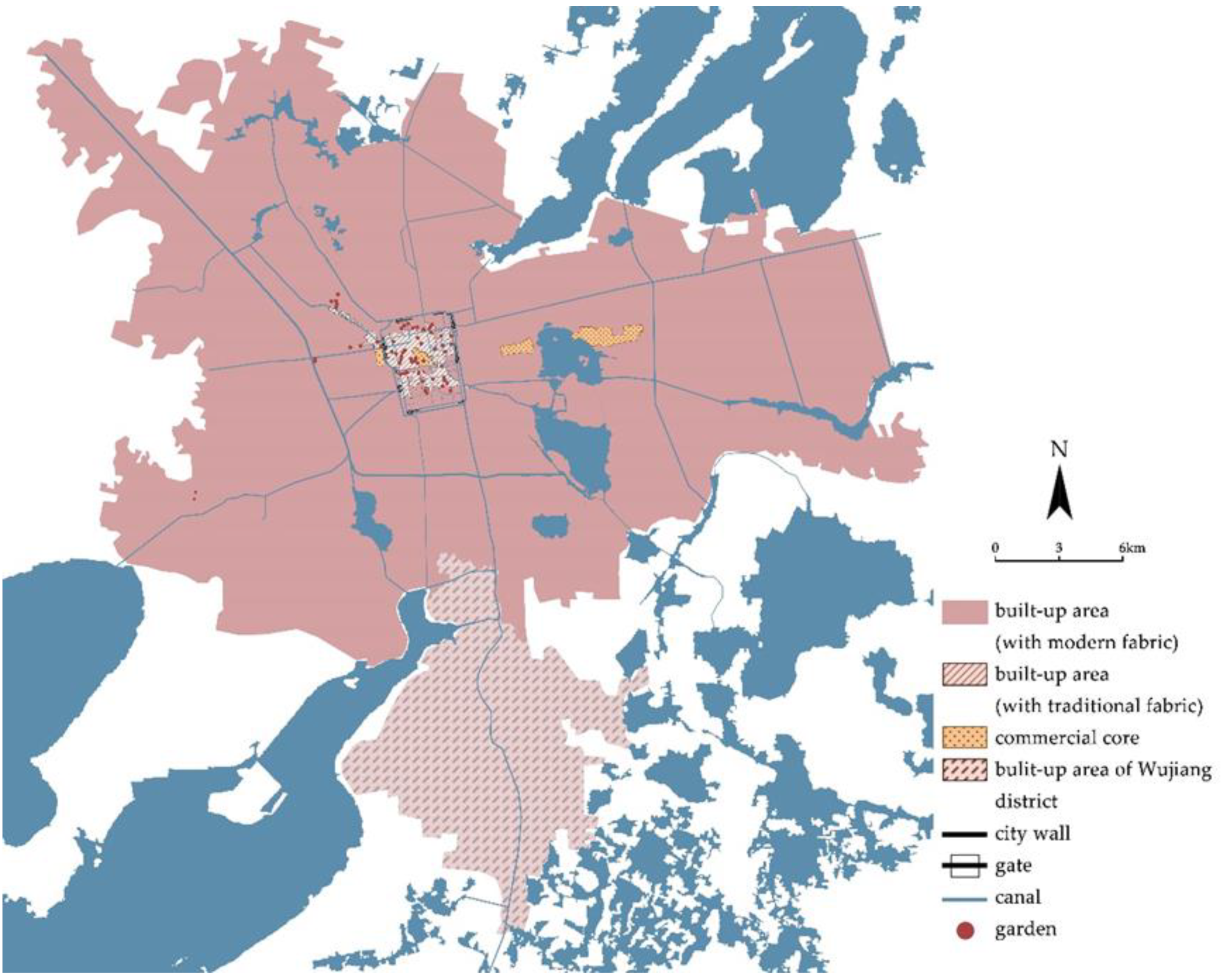
This paper takes Suzhou (the prefecture-level city) as the research object (Figure 1), and takes 1949 (the founding of the People’s Republic of China) and 1978 (the economic reforms and opening up of China) as two key time points. Through the use of historical documents, ancient maps, and local chronicles, we determined the distribution of the built-up area and river channels of Suzhou City and obtained the urban form of different periods. Specifically, we used the “Map of Pingjiang” from the Southern Song dynasty, the “Map of Waterways in Suzhou” from 1639 in the Ming dynasty, the “Map of Gusu”, the “Map of Suzhou”, the “Complete Map of Suzhou”, and the “Map of Suzhou Prefecture” from the Qing dynasty, the “Newly Surveyed and Detailed Map of Suzhou and its Outskirts” and the “Latest Suzhou City Complete Map” from 1913 to 1949 to summarize the changes in the built-up area, the water systems, and the location of Suzhou’s major facilities before 1949; we also determined the urban landscape changes of Suzhou from 1949–1978 and 1978 to the present using official documents and Satellite data provided by Suzhou Natural Resources and Planning Bureau. The historical background and related changes of Suzhou’s traditional gardens listed in the World Heritage List were further clarified through the detailed information provided by Suzhou Landscape and Greening Bureau. We determined the current urban landscape of Suzhou through field investigation.

4. Results

4.1. The Spatial Pattern and Historical Geographical Development of Suzhou

4.1.1. The Pattern of Suzhou City Pre-1949

The ancient city of Suzhou was built in 514 B.C. More formal and complete local records and maps mainly appeared in the Song dynasty. Therefore, we take the Song Dynasty as the starting point to study the urban transformation of Suzhou. During this period of feudal society, the urban form changes in Suzhou were mainly concentrated within the city walls. The Suzhou City Wall was built in the Spring and Autumn period and the Warring States period. However, due to the massive demolition of the city wall in the Qin dynasty, most of the city walls foundation sites that can be excavated today are from the Han dynasty, and, although the walls of Suzhou have been destroyed or rebuilt several times due to warfare since then, the site of the walls and the area they enclose have not changed significantly since Sui dynasty [16].
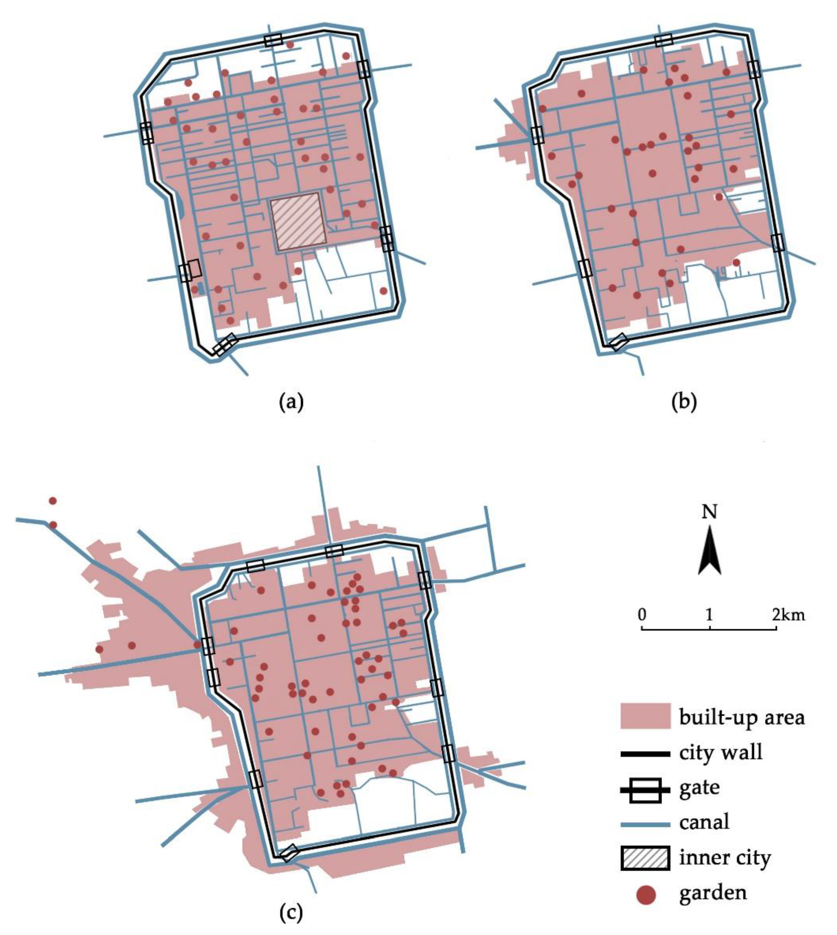
The Song dynasty was an important period of urban development in China. Suzhou had become a handicraft city with a certain scale at this time, and its economy had grown considerably. The former square market system in the city was replaced by the street market system, resulting in increased vitality and faster construction [17]. The theory of urban morphology pays attention to the “fixation line”, which largely limits and restricts urban development [10]. The Suzhou City Wall also greatly affected the development of the urban form during this period, and, due to military requirements, there was still an inner city that was the location of important military and administrative facilities surrounded by walls. Suzhou in this period had a clear axis and urban core. Zhang’s article also shows that the existence of the inner city during the Song and Yuan dynasties largely influenced the distribution of buildings in the city of Suzhou [18]. The administrative buildings of this period were mainly concentrated in the southern part of the city and the inner city, while the residential areas and temples were distributed in the north of the city with the Ganjiang River as the axis. The built-up area within the city had not yet filled the space enclosed by the entire city wall, and the urban form was limited by the city wall on the east and west sides, while the north and south sides had not yet overlapped with the city wall. Thus, the built-up area reflects obvious urban fringe belts (Figure 2a).
During the Ming and Qing dynasties, Suzhou further increased its economic and political status and became the most important handicraft and commercial city in the country [19]. During this period, the inner city destroyed by the war was not rebuilt, and, with the disappearance of this original core of the city and the influence of the Jinghang Canal, the commercial core of the city changed from its original layout located around the inner city to one in the direction of the Chang Gate. The urban form of this period began to cross the city wall, and the fringe belt of the city also broke through the wall at the northwest corner and thereafter led to the prosperity of Shantang Street (Figure 2b).
Due to social turmoil in the late Qing dynasty and the Republic of China, the rise of Shanghai as a port and the opening of the Shanghai–Nanjing Railway in 1908 changed the pattern of the original regional economic center of Suzhou, and the originally prosperous business district around the Chang Gate suffered a huge blow, causing business to begin to move to the east so that the original commercial center near the inner city once again flourished [20]. During this period, the built-up area of Suzhou began to expand to the southwest and east, but some farmland remained within the city walls, and an inner fringe belt appeared (Figure 2c). It is noteworthy that during this period, the first relatively systematic urban planning in Suzhou in modern times, the “Vision of Suzhou Public Works Plan”, appeared [21]. Although this was not fully realized due to the war, its emergence marked the beginning of the urban development of Suzhou from a completely natural growth stage to a stage with a certain degree of systematic planning.
Additionally, since Suzhou is located in the Yangtze River Delta, which is rich in waterways, these rivers are closely related to people’s daily life, and a parallel urban pattern of waterways and streets was formed during an early stage of the city. As an important transportation space, the number of canals reached a peak in the Song dynasty, and with the expansion of the built-up area to the north and south and the expansion of the residents’ living space into the water, the number of canals continued to decrease, but their overall structure remains relatively intact, basically maintaining the pattern of “three horizontal, four straight and two rings” [22]. It can be considered that the rich water system and the city walls together formed the most important landscape feature of Suzhou in this period.
In addition, the admiration for gardening, coupled with the rise in economic standards, gardening became a common practice in Suzhou during the Song dynasty. The transformation of Suzhou into a handicraft city and the changing location of government buildings in the city led to a changing distribution of private gardens [23]. However, the number of gardens in the city was always on the increase. By the Ming and Qing dynasties, Suzhou’s gardening activity reached its peak [24]. The transfer of commercial centers in the city and massive population growth led to a decrease in per capita floor space, which led to a further reduction in the scale of Suzhou traditional gardens during the Ming and Qing dynasties, but also to a peak in their numbers [25]. From the Jiajing period of the Ming dynasty to the Qianlong period of the Qing dynasty, the accumulation of recorded gardens in Suzhou had reached more than 300, and, during this period, it is said that in Suzhou, “half of the city was occupied by gardens and pavilions” [1] (p. 225). Although Western-style architecture and modern parks began to be introduced in the late Qing dynasty and the Republic of China [17], the rich and exquisite Suzhou traditional gardens were still another important landscape feature of the city.

4.1.2. The Pattern of Suzhou City from 1949 to 1978

Usually, we think of 1949 as the beginning of modern Chinese history and the starting point of the modern development of Chinese cities. With the acceleration of industrialization and the left-leaning social production movement that began in 1958 [26] (pp. 9–15). Although the industrial output value of Suzhou grew from CNY 205,870,000 to CNY 240,898,000 between 1949 and 1978, a large number of original houses in the ancient city were transformed into factories, nearly 280 factories had been converted directly from residential buildings, and farmland to the north and south of the ancient city has been converted into danwei residential compounds or large factories, while the built-up area outside the city also consisted mainly of them. Most of the city walls of Suzhou were destroyed, and only the Jin Gate, Pan Gate, and Xu Gate survived; a large number of gardens were also destroyed during this period [27,28] (pp. 427–430). Additionally, under the influence of the industrial-led development model, the government strictly limited commercial, Suzhou’s handicraft and commercial base developed during the late Qing and Republican periods gradually declined [29]. In 1959, Suzhou City issued its first urban planning after the founding of the People’s Republic of China, which clearly stated that Suzhou would focus on traditional industry and tourism and that the planned land would be expanded from 19 square kilometers to 32 square km. The relocation of factories in the ancient city to outside the urban area to strengthen the characteristics of Suzhou as a garden city was also proposed [28] (p. 361). At this time, the urban form had broken through the fixation line (city walls) of the city on the north, west, and south sides, and the planning also included the Beijing–Hangzhou Grand Canal as the boundary of the new urban development. However, due to political reasons, this planning scheme was abolished the following year. During this period, Suzhou’s urban development had a certain plan to follow, and the overall development was not fast, but the original plan could not ultimately be fully implemented due to time factors. As a result, although the natural growth had converged, this was still the main mode. Because of the industrial-led development model and the utilization of the existing infrastructure in the ancient city, the internal changes of the ancient city began to erode the original urban landscape, and the urban landscape of Suzhou began to decline (Figure 3).
During this period, Suzhou’s water system was also greatly damaged, and a large number of rivers were directly filled in due to sanitation problems and the construction of new houses. A total of 23 rivers (totaling about 16.317 km in length) were filled in, and Suzhou’s water network shrank from the original “three horizontal, four straight, and two rings” model to a “three horizontal, three straight, and one ring” model [28] (p. 448). This also led to the further disintegration of the urban pattern in the ancient city, which consisted of canals, streets, and city walls.
Under the influence of left-leaning ideology, like the city walls, gardens were seen as symbols of feudalism at this time, so numerous gardens and temples were encroached upon or suffered great damage, and the development of the ancient city fell into a state of imbalance in which the economy completely overrides culture. Although famous gardens such as the Humble Administrator’s Garden, the Lingering Garden, the Garden of the Master of Nets, and the Pavilion of Surging Waves were restored and opened to the public as special public spaces between the 1950s and 1960s, only a few of the hundreds of gardens that once existed in the city eventually survived [30]. These traditional gardens, once an important feature of the urban landscape, also began to decline during this period.

4.1.3. The Pattern of Suzhou City Post-1978

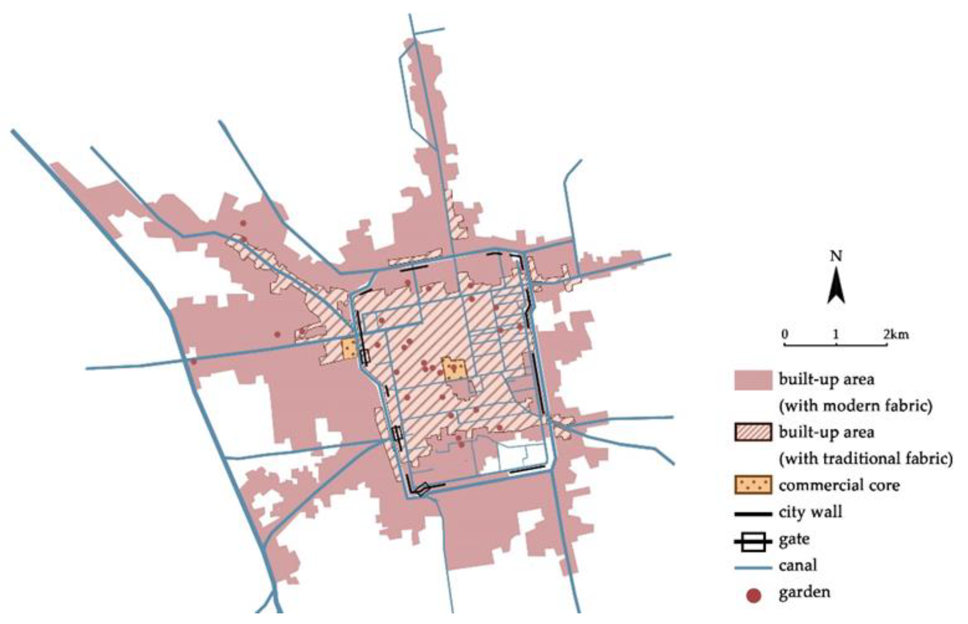
The year 1978, a very important year in China’s modern history, marked a period of rapid urbanization [31]. By 1985, Suzhou was listed as a national coastal economic development area, and the national economy was rapidly improving, with the gross national product reaching CNY 2,341.04 million that year, an increase of 21.27 times from 1952. Among others, the gross domestic product of the pillar industry of the textile industries (including the silk industry) increased 53.7 times compared with 1949, accounting for 27.8% of the total industrial output value in 1985 [26] (pp. 3–4). While the economy was developing rapidly, Suzhou’s urban construction began to re-enter a planning-oriented development mode. In 1982, the city was listed as a national historical and cultural city, with the clear goal of comprehensively preserving the ancient city of Suzhou. In 1986, the “Suzhou City Master Plan (1986–2000)” was introduced, defining the city as a famous historical and cultural city and a scenic tourist city and emphasizing the goal of comprehensively protecting the features of the ancient city and actively building a new modern district. The population density of the ancient city would be controlled, and industries in the ancient city would be gradually transformed into tourism and service industries and a large-scale commercial center was formed in the Guanqian area and the Shilu area, which previously declined due to commercial decline has once again become the regional commercial center; the proportion of primary, secondary and tertiary industries in Suzhou changed from 17.3: 61.0: 21.7 in 1990 to 5.9: 56.5: 37.6 in 2000 [1,32] (pp. 307–308). New and expanded factories or public buildings that attract large crowds were strictly prohibited in the ancient city, and factories would be further relocated to industrial areas outside the city. The new industries outside the ancient city had shifted from the former labor-intensive industries to technology-intensive ones, and because of the reduced dependence on geographical location, the new industrial zones set up centrally in the Gaoxin district on the west side had not been formed, but industries expanded along roads and other axes [33]. In addition to a small degree of radiation spreading from the ancient city, the city as a whole developed in a westward direction, gradually filling the area between the city walls and the Jinghang Grand Canal. Although the development of the Gaoxin district brought a chance for the preservation of the ancient city, the disintegration of urban fabric did not stop (Figure 4).
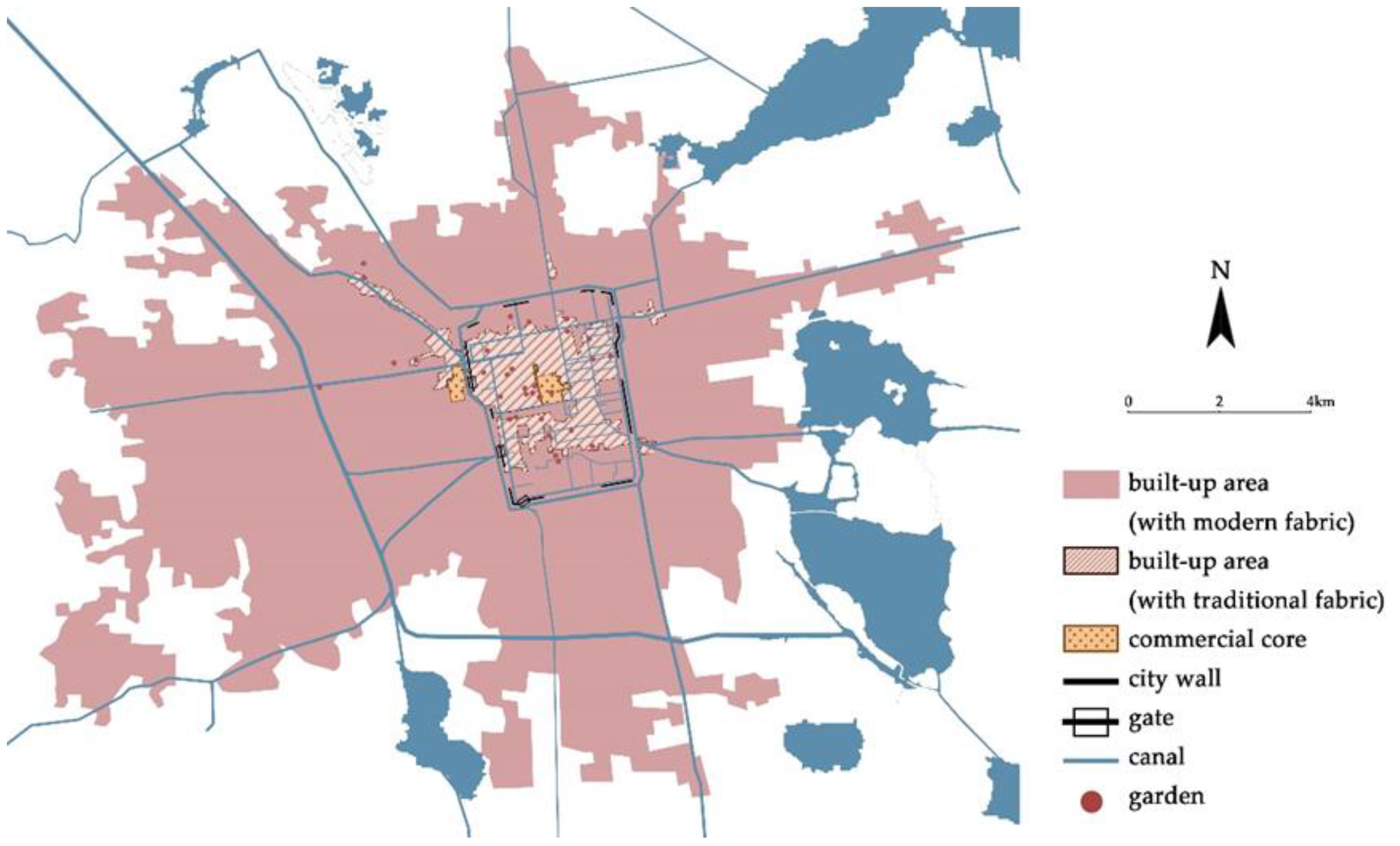
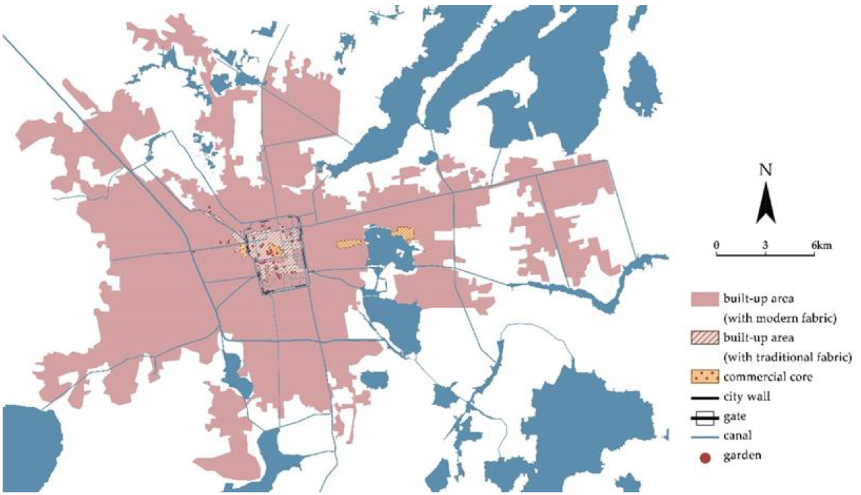
With the continuous improvement of the market economy, Suzhou has become one of the most economically developed regions in China under the joint promotion of the private economy and foreign capital. In 2001, the GDP of Suzhou’s central city was CNY 61.856 billion, which surged to CNY 357.275 billion in 2010, an increase of about six times. In 1996, the “Suzhou City Master Plan (1996–2010)” was issued, and the overall urban layout of the city was formed by the ancient city (Old Suzhou), the Gaoxin district (New Suzhou), and the Industrial Park (Foreign Suzhou) under the premise of protecting the ancient city. In this period, the urban landscape in the ancient city was further protected, the proportion of the service industry continued to rise, and the ratio of primary, secondary and tertiary industries was adjusted from 5.2: 56.8: 38.0 in 2001 to 1.7: 56.9: 41.4 in 2010 [34]. The Gaoxin district and Industrial Park further absorbed populations and industries emigrating from the ancient city and the transformation of Suzhou’s industrial structure has profoundly affected the evolution of its urban form [1] (pp. 307–308). The city scale grew rapidly; the west and south side completely broke through the Jinghang Grand Canal, which was the fixation line in the previous period, the north side broke through the area with Suzhou Railway Station as the core, and the built-up area with high-tech factories and new-style residential zones on the east side spread rapidly to the east shore of Jinji Lake (Figure 5 and Figure 6). Moreover, while the built-up area of the whole city was spreading rapidly, the original planned commercial center had not yet been completed [35].
In the “Suzhou City Master Plan (2011–2020)”, Suzhou’s urban nature is defined as a national high-tech industrial base expanded from the original national historical and cultural city and scenic tourist city. Under the guidance of this plan, the ancient city was further protected and the population was basically stabilized at 740,000. By 2020, the regional per capita GDP of Suzhou reached USD 22,975, with 1% in primary industries, 46.5% in secondary industries, and 52.5% of the industrial structure in tertiary industries, of which the total industrial output value of high-tech industries reaches CNY 1,659.955 billion [36]. At the same time, the Industrial Park has concentrated a large amount of resources and evolved rapidly, not only has gathered a large number of high-tech enterprises but also the emerging commercial centers on both sides of Jinji Lake have taken shape. Moreover, as a district integrating complete urban functions, it has become a sub-center of Suzhou [37]. At present, the new master plan of Suzhou is still under preparation, and the districts are now taking the “recent implementation plan” as a transition. The implementation plan of each district basically follows the urban positioning and pattern of the “Suzhou City Master Plan (2011–2020)”, and promotes urban infrastructure construction such as rail transportation; additionally, the new urban area in the north and the eastern urban sub-center are further strengthened [38,39,40,41,42,43]. During this period, Suzhou has expanded rapidly in all directions, with the ancient city becoming a service-oriented urban area, and the main industries have been transferred to the surrounding areas, the disintegration of the traditional urban fabric has also stopped. The urban development has changed from occurring in a specific direction as seen in the previous historical period to an even development of the surroundings. In many directions, the built-up area of the central urban area has been integrated with scattered villages and towns. It has even expanded to the prefecture-level administrative boundary of Suzhou on the east side, merging with Kunshan, which is a county-level city under Suzhou City (Figure 7).
Since the reform and opening up of China, the protection of urban landscapes has led to the correction of unsuitable approaches to urban canals and the protection of the existing waterway pattern of “three horizontal, three straight, and one ring”. Since then, most of the canals have been scientifically managed; however, due to the water traffic being basically retired from the historical stage, as well as the expansion of urban scale, the pattern of canals, streets, and traditional urban space together has not been further expanded to areas outside the ancient city.
With the recognition of Suzhou traditional gardens as a cultural heritage site by the Chinese government and other international organizations, the conservation of Suzhou traditional gardens is continuously improving. In 1997 and 2000, nine traditional gardens in Suzhou, including the Humble Administrator’s Garden, the Lingering Garden, the Garden of the Master of Nets, and the Pavilion of Surging Waves, were inscribed on the UNESCO World Heritage List. By 2015, the number of gardens in the “Suzhou Garden Directory” had been gradually expanded to 108, and a large number of gardens that were destroyed in the last century have been restored according to the three models of “comprehensive protection, restoration protection, and site protection” and the requirements of “authenticity, integrity, and continuity” to recreate the scenery of the “City of Hundred Gardens” in Suzhou [44]. At this stage, Suzhou gardens have become a popular leisure place for the public in the ancient city, and these former private houses have undergone a new identity change in the new period, becoming a public space with local characteristics of Suzhou.

4.2. Urban Landscape Structure under the Changing Urban Pattern of Suzhou

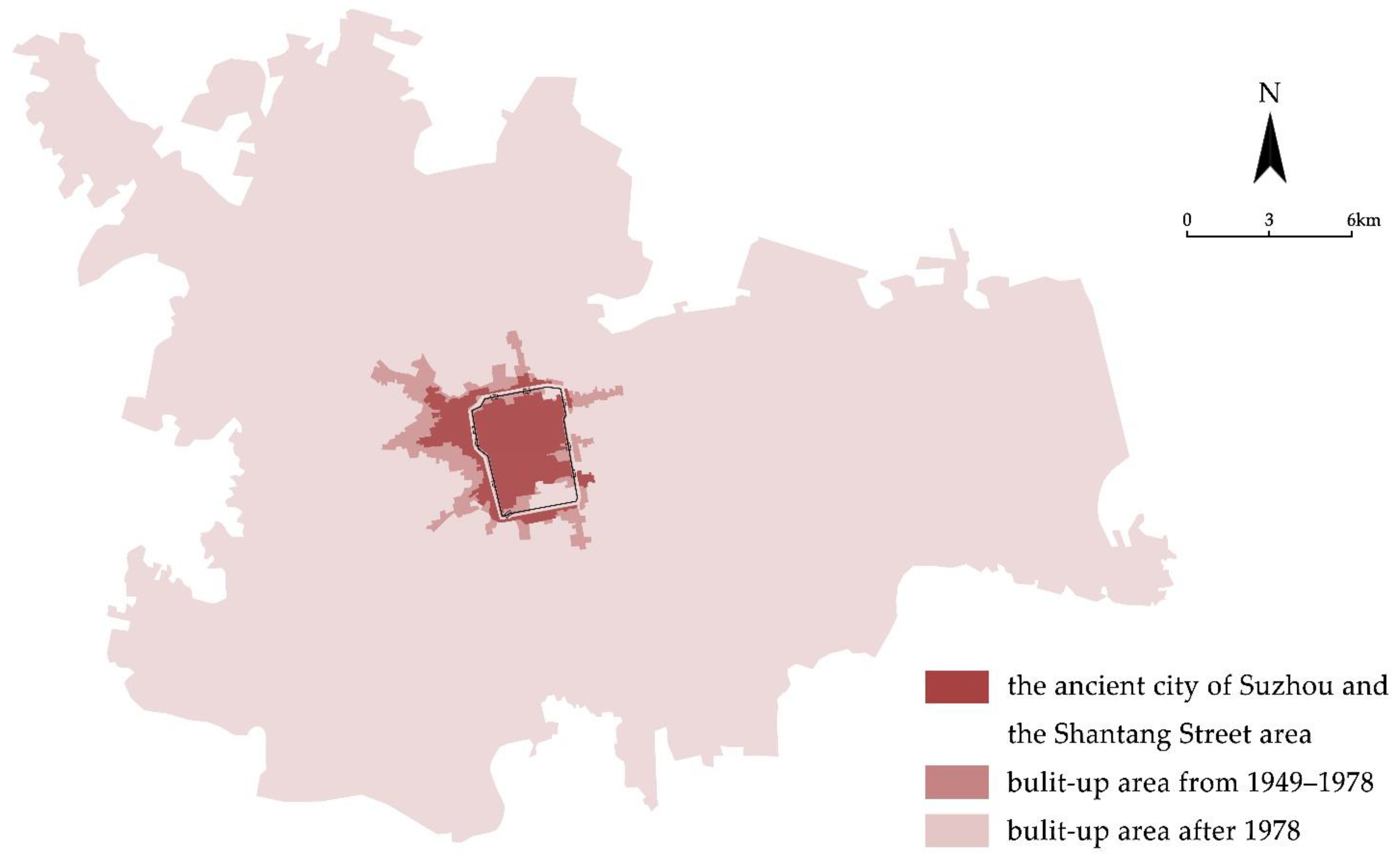
The changes in Suzhou during these three periods culminated in the current urban form (Figure 8), consisting of the ancient city and the Shantang Street area (including the ancient city wall and moat), the urban area built between 1949 and 1978, and the urban area built post-1978 (excluding the Wujiang district, which was merged in 2012).
The ancient city, which was formed slowly over the past thousand years, has undergone drastic changes, but it still preserves a large area of the traditional water system, architecture, and street features. Nowadays, the Pingjiang Historical and Cultural District, the Shantang Historical and Cultural District, the Humble Administrator’s Garden Historical and Cultural District, the Yi Garden Historical and Cultural District, the Chang Gate Historical and Cultural District, and a large number of cultural relic protection units constitute the core elements of the urban landscape in this area, and its urban fabric mainly consists of the traditional east–west long and narrow plot courtyards with some large irregular-shaped courtyards (i.e., Suzhou traditional gardens). The ancient city walls and moats have been subject to complex influences over a long historical period, although their existence has ensured the continuation of the urban landscape elements and urban fabric of the ancient city. However, the production movement in the 1960s and 1970s caused the most complete damage to the walls leading to the loss of their original function so subsequent restoration has not been able to recreate the intact walls of places such as the ancient city of Pingyao [45]. Today, the Suzhou City Wall is combined with later-built parks or scenic spots serving as urban public spaces or as a spatial reminder for the boundary between the ancient and new urban areas. It has changed from being a continuous circular landscape belt in the past to a landscape element that appears only in fragments around the ancient city. The moat, on the other hand, has been relatively fortunate in that it has not changed much since the Song dynasty and has not been subjected to large-scale filling or damage in the last century, remaining largely intact. The continuous circular moat preserves the original boundaries of Suzhou’s ancient city and provides the basis for the construction of many urban public spaces, especially the urban parks, it also provides support for the sustainable development of the city (Table 1a).
Due to the need for industrial development at that time, the urban areas built between 1949 and 1978 were basically in the vacant land on the west side of the ancient city. Although the pace of urban development during this period was relatively slow, the commercial and residential areas that evolved in these areas were quite different from the urban landscape of the ancient city. Due to the requirements of social production methods and the preference for industry at the time, almost all of these residential areas were in the form of “danwei residential compounds” [46]. Their exterior is surrounded by walls and the building form gradually evolved into multi-story buildings during the renovation. These buildings are no different from buildings in other cities during the same period, and the homogenization of the urban landscape has become a threat; they have largely changed the urban fabric and skyline of Suzhou’s west side. Although the urban water system has a relatively high density, the form is more irregular than the water system in the ancient city (Table 1b).
Since 1978, with the rapid urbanization of Suzhou, a large number of residential areas, public buildings, industrial zones, and commercial areas have been built to promote the expansion of the city, and these have gradually filled the inner fringe belt of the ancient city also eroded the original urban fabric. The urban landscape in these areas shows more different features: the residential areas are mainly located near the main arterial roads or subway lines, and they are as enclosed as the residential areas built between 1949 and 1978; the population increase has also led to a high number buildings with many floors, from 5 to 7 floors in the 1990s were replaced by from 20 to 30 floors and higher at present; the volume of commercial and public buildings has also expanded dramatically, and a large number of super high-rise buildings with glass curtain walls have appeared; although the industrial zone is located near the fringe zone, the volume of buildings in this area is also much larger than in the traditional industrial zone. Due to a large amount of vacant land in the urban fringe belt and the weakening influence of geographic factors on urban expansion, the new urban area shows a more obvious expansion in all directions; the urban landscape has also changed greatly, especially the industrial park, which is the sub-center of Suzhou (Table 1c).
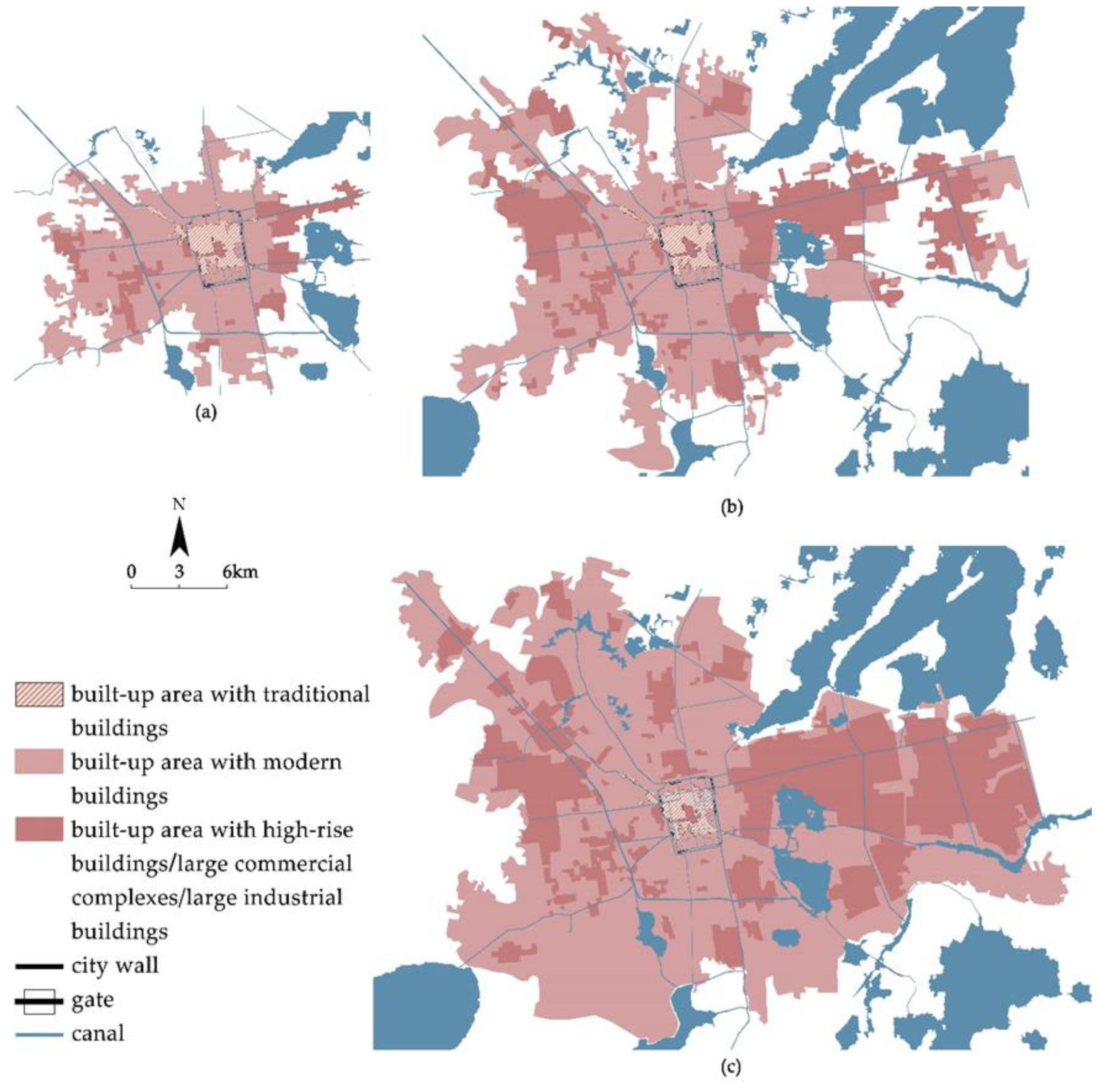
Due to its long development process of 2500 years, the urban landscape of Suzhou is complex and diverse, and the urban landscapes of different historical periods highlight the social concepts of the corresponding periods and also show us the challenges of urban culture and characteristics in the process of urban development: the urban landscape of Suzhou formed in different morphological periods appears to be largely incongruous; the vigorous development of the economy and the intervention of the modernist style make many urban areas unable to recall traditional Suzhou in terms of spatial perception. This urban landscape that has developed in recent decades is gradually causing Suzhou’s landscape from the previous millennia to disintegrate or fragment, especially with the massive emergence of large commercial complexes, large industrial buildings, and high-rise buildings since 2000 (Figure 9).
As a unique urban heritage that combines traditional architecture with highly artistic nature, Suzhou traditional gardens have undergone a transformation from private to public in the period from 1949 to the present, in addition to decreasing in number and growing again. Since the 1950s, gardens have been transformed from private residences to public spaces open to the public, and based on the rich and intact architectural and natural environment within the gardens, Suzhou traditional gardens have become a daily leisure space for the residents of the ancient city to drink tea and enjoy Suzhou opera [47]. It is noteworthy that, as a public space with local characteristics, such spaces are mainly located in the ancient city and are rare in the newly built urban areas.

5. Discussion

5.1. Problems of Urban Planning Reflected by Changes in Urban Landscape

It is undeniable that Suzhou’s urban planning began at a fairly early stage. The above mentioned a number of urban plans from 1959 to 2011. These plans clearly show the tendency of urban construction in different periods. Although they all consciously protect the local characteristics of Suzhou, almost all the protections are concentrated on the protection of the existing part of the ancient city. In the detailed rules of the “Suzhou Historical and Cultural City Protection Plan (2013–2030)”, the idea of dividing Suzhou into “Old Suzhou”, “New Suzhou”, and “Foreign Suzhou” is still conveyed [48]. Although this strict division has played a role in the conservation of the ancient city, when we look at the current urban landscape of Suzhou, it can be easily observed that although the ancient city and other areas are not spatially divided, this planning idea has actually caused the separation of the ancient city from other areas of Suzhou in terms of the urban landscape. This has contributed to the transformation of the process of preserving the ancient city into a process of heterogeneity between the historic center (the ancient city) and its surroundings. In other words, the current urban plans only follow the trend of urban development; they do optimize the space within the ancient city, but, for the surrounding urban areas, they still build on the previous imbalanced urban patterns and economic-focused development approaches.
As an important commercial center in the past, the area around Guanqian Street in the ancient city was developed earlier, and the traditional relationship between the street and the stores along the street was completely broken with the formation of large and regular modern building complexes in a 215-hectare area to further support the commercial development. However, this has led to a different urban landscape in the city center as compared to the surrounding area (Table 2a). In addition, due to the late development of the southern area, the development approach from the 1980s to the beginning of this century resulted in the existing communities in this area having similar building layouts and heights to those outside the ancient city, although there are no walls. The urban fabric formed by the building threatens the integrity of the ancient city fabric (Table 2b). It is true that under the guidance of urban planning, the buildings in the historic district have been properly protected and updated in accordance with the needs of society (such as the design of Suzhou Museum in this regard), but these buildings built in the past few decades are different from those of the ancient city, and they do not have a corresponding update plan to solve the problem of their coordination with other areas in the ancient city; instead, they exist as static “foreign bodies”.
In the face of the incongruity within the ancient city, as well as the incongruity between the ancient city and other regions, we should recognize that the sense of place as a human interaction with space and the resulting emotional attachment to place is essentially a special relationship between people and place after the transformation of cultural and social characteristics [49,50]. The sense of place is also inseparable from personal identity, and the physical and symbolic characteristics of place are embodied in the sense of personal identity as a sense of place [51]. Identification with place determines sentimental attachment to landscape and cultural values of an area, and motivates preservation and promotion of such values. A strong local identity favors the growth of sustainable development models, because sustainable development tends to be based on the promotion of local specificities [52]. Suzhou as a whole should form a similar sense of place identity in the daily life of its inhabitants, instead of forming different place identities based on the concept of “districts” and evolving genius loci that are separate from each other. The current plan focuses on the protection of the ancient city; advocates a “Suzhou-style life”, which is a traditional, slow-paced lifestyle; and emphasizes the tourism and service industry as the mainstay industries. However, by default, other post-development areas have been built in a “new” way, and, in the process of promoting openness and tolerance, the problem of urban homogenization has been ignored, especially in industrial parks. Such a situation leads to the possibility that the place identity of Suzhou’s residents faces further separation as the plan advances. In essence, this is a disconnect between the current urban planning, the site, and its residents; it also demonstrates the current urban planning’s disregard for the historical continuity of the overall city.
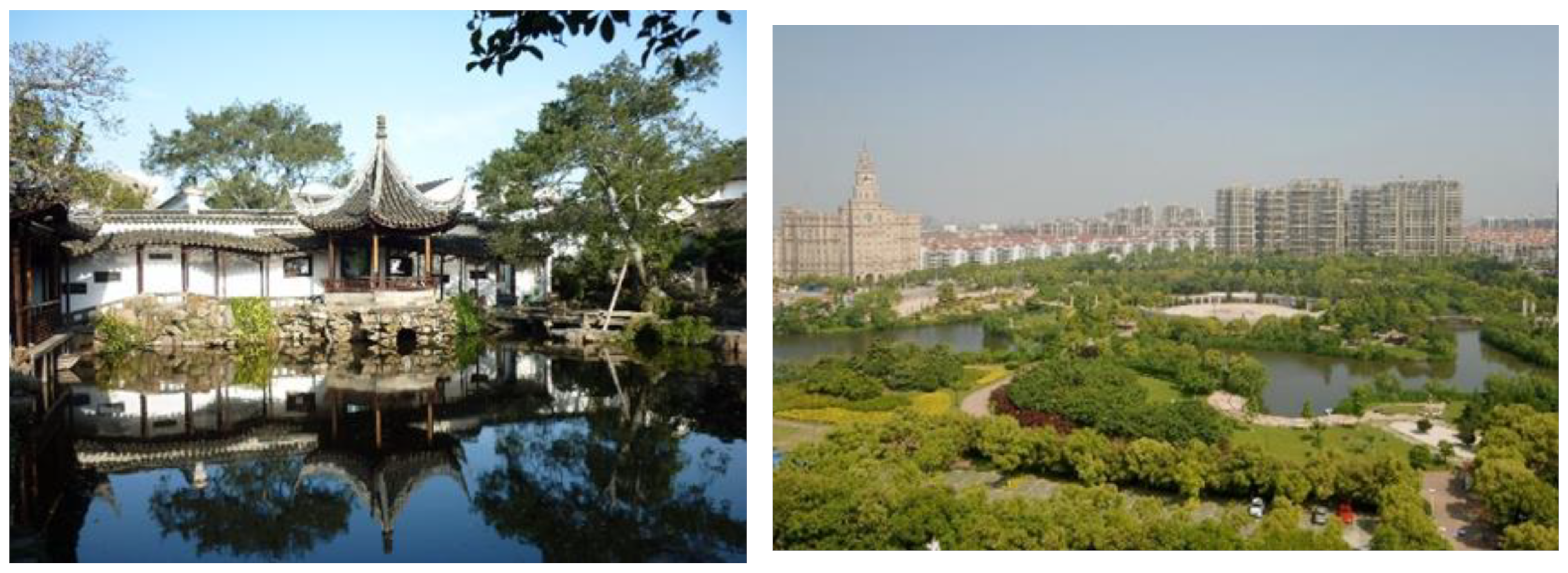
As an urban heritage and unique public space that carries the living habits of the residents in the ancient city. The daily life of the residents in Suzhou gardens is highly local and can shape a strong place identity. The conservation and development of this public space will be an important prerequisite for sustainable development. As Manenti argues that “sustainability, that is the transmitted of architectural and cultural heritage of the area to new generations, can also be interpreted as conservation, restoration and creation of places which are symbolic and representative of common life. And if human experience is necessarily relational, the places of relationship in which you can interpret the values of coexistence can only be a legacy; preserved, improved and transmitted” [53]. Goldsteen and Elliot (1994) assert that “the word identity has distinct advantages in terms of open spaces, streets, and spaces between buildings because it encompasses the notion of a specific location and the unique relationship between the place and its context” [54]. However, Suzhou traditional gardens, as an urban heritage full of regional aesthetic values, have not developed outside the ancient city while assuming the role of public space for its residents to further shape a similar sense of place identity to ensure the sustainable development of Suzhou. Residents of the newly built-up areas are exposed to the urban spaces based more on modernist urban parks or commercial spaces (Figure 10), which creates a lack of regional cultural values and traditional aesthetics, and this reality together with macro planning makes the urban landscape feature of Suzhou more fragile and sensitive.

5.2. The Value of HUL and Implications for Current Planning

As a new method of urban conservation, scholars are also exploring the possibilities of urban conservation in HUL from various perspectives, and the study of Venice is particularly noteworthy. As a city with many similarities to the ancient city of Suzhou, both cities have not only developed water systems but also preserved a large amount of urban heritage but due to the difference in the volume of the city Psarra’s study of Venice focuses on the relationship between the city and the community and the complexity of the urban heritage in both the figurative and abstract sense [55]. Rosa and Palma’s study of Naples, on the other hand, shows the importance of a culture-based urban development model from the HUL perspective for sustainable urban development in the post-industrial era [56]. Although our study focuses on the impact of changes in the urban landscape caused by the development of urban form from the HUL perspective on local identity and place attachment, these studies of Italy provide us with strong support for the intangible part of the tangible urban heritage carried by HUL in dealing with the issue of sustainable development. HUL regards urban heritage as the engine for the development of the historic environment and the entire urban space, which requires the preservation of this urban heritage beyond the material achievements of the particular era and socio-cultural context, and thus integrates the possibilities of creating future sustainability, which must focus on the intangible and spiritual components [57,58,59]. The current urban planning in Suzhou also requires HUL’s intervention to achieve sustainable development. Additionally, as a pilot city for HUL in China, more detailed rules should be applied to urban planning to deal with the problems caused by rapid urbanization.
Areas built in different periods have different landscape features that should be noted and coordinated to create a more coherent experience of the area as a whole, especially between the industrial park and the ancient city in the case of Suzhou. This experience not only concerns architectural forms and the urban landscape, but also intangible aspects. For now, in the ancient city of Suzhou, not only has the spatial atmosphere formed by the water system and the streets over thousands of years gradually become an island in the urban landscape, but the way of life around the small bridges and flowing water has also fallen into this dilemma. Although material reproduction of these spaces is not advocated, the Suzhou-style artistic spatial conception and value layering should be widely accepted in the city and would allow people to form similar place attachments, which is an important factor that would ensure the continuity of the city. For this reason, the continuity and unity of different districts in Suzhou should be considered from a micro perspective in the planning process so as to ensure the individual residents will have a correct perception of Suzhou’s features and develop the place attachment at a realistic level.
As the birthplace of Suzhou’s culture, the ancient city is the most intact part of the traditional urban landscape. As the most important calling card of Suzhou, the internal Suzhou gardens, together with the ancient city, should both remain at the material level considering both the macro and micro perspectives of their value and function. They, together with their surroundings, have been layered into the city’s identity in a continuous historical time and space and cannot be divided in the planning process. In this way, urban heritage and the surrounding environment should be managed together so that urban heritage can move beyond the single category of attractions or cultural relics, and then participate in the development strategy of the entire urban space together with the surrounding environment as an important structural element so as to achieve the unity of “history”, the “present”, and the “future” in the context of Suzhou. From the perspective of micro urban space, the re-naturalization of public space in conjunction with Suzhou gardens will not only provide residents with a green space to address environmental issues and traditional aesthetic values but also perpetuate their sense of place and achieve the goal of sustainable development. Administrators must recognize that place attachment prepares communities to become resilient and sustainable in the face of possible risks [60]. Moreover, a continuous place attachment in space and time allows public space to shift from “space” to “place” in response to the increasingly fragile urban landscape features [61]. This is crucial for both the new urban area and the ancient city of Suzhou.
Additionally, residents, as the shapers and experiencers of the city, are arguably the biggest stakeholders in the process of urban development [62,63]. Research also suggests that where consultation is inadequate, place attachment processes may become threatened [64]. Therefore, it is important to optimize short-term publicity and transform expert-government-led hearing modes in the current planning process to modes in which the public can participate in all of the relevant aspects, from macroscopic strategy development to microscopic neighborhood creation. These approaches will help to highlight the city’s identity while meeting the specific needs of its residents, which will undoubtedly be extremely beneficial to the sustainable development of Suzhou.

6. Conclusions

This paper analyzes the urban development patterns and landscape features of Suzhou, a city with more than 2500 years of history, in different historical periods through HUL. Specifically, the time periods of pre-1949, 1949–1978, and 1978–present are included, and the study of the three time periods is used to point out the parts of Suzhou’s current urban planning strategy that deserve improvement. This analysis has revealed that the ancient city of Suzhou has suffered a great deal of damage in the last few decades, and, after realizing this problem, the conservation of the ancient city of Suzhou has been carried out quickly and achieved phased results As a city that implemented urban planning earlier in China, the value of the ancient city has been recognized and protected, but the ancient city does not include the entirety of Suzhou: while the ancient city has been protected, opposition between the new city and the ancient city has begun to appear. The urban development model dominated by economic benefits has allowed Suzhou to distinguish between ancient city protection and urban development in the process of its rapid economic growth. This distinction has led to a fractured urban landscape, the increased fragility of urban heritage, and the erosion of traditional urban living spaces by modern architecture. The lack of research on how to further develop Suzhou traditional gardens, which have both aesthetic value and social functions, has led to further shrinkage of Suzhou’s local identity in newly built-up areas. These realities of rapid urbanization have resulted in a dramatic change in the city’s identity and thus poses a great threat to the continuity of the urban context and place identity.
The morphological approach shows the causes and consequences of the separation of Suzhou’s urban landscape during the development process and highlights that the need for tangible and intangible elements such as urban heritage and traditional lifestyles are no longer limited to the concept of mere “conservation”. This also conveys the message that Suzhou, as a typical city in China in terms of economic development and urban heritage conservation, has a greater responsibility to explore a sustainable development path that other cities can follow to effectively preserve urban heritage without creating a dichotomy between the old and the new. This requires interpreting the geographical elements and material and immaterial components of Suzhou from the perspective of HUL and connecting them to the city’s economic, political, cultural, and natural development processes. The exploration of the current urban landscape features and the residents’ place attachment should also form the core of urban planning, which will help Suzhou find a way to balance development and conservation in accordance with the needs of all parties.
In addition, urban conservation and sustainable development cannot be achieved without the full participation of the public. The current planning process is often dominated by experts and government departments, which can lead to conflicts with the public during the implementation of planning. However, using the HUL method reasonably will help reduce these contradictions and can better promote the building of neighborhoods. Although a perfect solution may not be found, this method will certainly help us to find a better balance between the public and the policy makers, and provide a good basis for creating a city with outstanding urban features, cultural richness, and livability.

Author Contributions

Conceptualization, J.J. and T.Z.; methodology, J.J.; software, J.J.; validation, J.J., Y.H. and K.I.; formal analysis, J.J.; investigation, J.J. and T.Z.; resources, Y.H. and K.I.; data curation, T.Z. and Y.H.; writing—original draft preparation, J.J.; writing—review and editing, J.J. and T.Z.; visualization, J.J.; supervision, K.I.; project administration, K.I.; funding acquisition, K.I. All authors have read and agreed to the published version of the manuscript.

Funding

This research received no external funding.

Institutional Review Board Statement

Not applicable.

Informed Consent Statement

Not applicable.

Data Availability Statement

Not applicable.

Conflicts of Interest

The authors declare no conflict of interest.

References

  1. Suzhou Local Chronicles Compilation Committee. Suzhou Shizhi 1986–2005; Phoenix Science Press: Nanjing, China, 2014; Volume 1, pp. 5–6, 4, 225, 307–308. [Google Scholar]
  2. Liu, T.; Butler, R.J.; Zhang, C. Evaluation of public perceptions of authenticity of urban heritage under the conservation paradigm of Historic Urban Landscape—A case study of the Five Avenues Historic District in Tianjin, China. J. Archit. Conserv. 2019, 25, 228–251. [Google Scholar] [CrossRef]
  3. Lin, L. Conservation of Historic and Cultural Cities in the Context of the New Normal: Perspective of Historic Urban Area. Urban Plan. Forum 2016, 4, 94–101. [Google Scholar] [CrossRef]
  4. UNESCO. Pilot Cities in China. Available online: http://www.historicurbanlandscape.com/index.php?classid=6043&id=40&t=show (accessed on 2 July 2022).
  5. Kırmızı, Ö.; Karaman, A. A participatory planning model in the context of Historic Urban Landscape: The case of Kyrenia’s Historic Port Area. Land Use Policy 2021, 102, 105130. [Google Scholar] [CrossRef]
  6. UNESCO. Vienna Memorandum on ‘World Heritage and Contemporary Architecture-Managing the Historic Urban Landscape’; UNESCO: Paris, France, 2005. [Google Scholar]
  7. UNESCO. Recommendation on the Historic Urban Landscape; UNESCO: Paris, France, 2011. [Google Scholar]
  8. Council of Europe. European Landscape Convention; Council of Europe: Florence, Italy, 2000. [Google Scholar]
  9. Sauer, C.O. The Morphology of Landscape; 2007 Foundation Papers in Landscape Ecology; University of California Press: Berkeley, CA, USA, 1925; pp. 36–70. [Google Scholar]
  10. Whitehand, J.W.R.; Samuels, I.; Conzen, M.P.; Conzen, M.R.G. 1960: Alnwick, Northumberland: A study in town-plan analysis. Institute of British Geographers Publication 27. London: George Philip. Prog. Hum. Geogr. 2009, 33, 859–864. [Google Scholar] [CrossRef]
  11. Whitehand, J. Urban Morphological Regionalization and Historical Urban Landscapes; World Heritage Papers No. 27; UNESCO World Heritage Centre: Paris, France, 2010; pp. 35–44. [Google Scholar]
  12. Zhang, W.Z.; Han, F.; University, T. A Review of the Theoretical and Practical Research on Historic Urban Landscape. Landsc. Archit. 2017, 24, 22–28. [Google Scholar] [CrossRef]
  13. UNESCO. The HUL Guidebook; UNESCO: Bad Ischl, Austria, 2016. [Google Scholar]
  14. Deng, K.; Song, F.; Shi, Y. Historical Urban Landscape from the Perspective of Cultural Landscape. Landsc. Archit. 2018, 25, 4. [Google Scholar]
  15. Statistics Department of Suzhou. Suzhou Statistical Yearbook 2021. Available online: http://tjj.suzhou.gov.cn/sztjj/tjnj/2021/zk/indexce.htm (accessed on 2 July 2022).
  16. Li, Q. Research on the Protection and Renewal Design of Suzhou Ancient City Wall and Its Environment—Take Pingmen Section as an Example. Master’s Thesis, Soochow University, Suzhou, China, 2020. [Google Scholar]
  17. Chen, y. Study on Urban Morphological Evolution of ancient Suzhou. Urban Plan. Forum 2002, 141, 55–60. [Google Scholar]
  18. Zhang, T.; Lian, Z. Research on the Distribution and Scale Evolution of Suzhou Gardens under the Urbanization Process from the Tang to the Qing Dynasty. Land 2021, 10, 281. [Google Scholar] [CrossRef]
  19. Fan, J.; Luo, X. A Study of Suzhou as the Economic Center of China during the Ming and Qing Dynasties. Collect. Pap. Hist. Stud. 2020, 3, 48–59. [Google Scholar] [CrossRef]
  20. Chen, Y. Study on Urban Morphological Evolution of modern Suzhou. Urban Plan. Forum 2003, 148, 62–71. [Google Scholar]
  21. Zhou, M. The Analysis and Study on “City Planning of Suzhou”. Master’s Thesis, Wuhan University of Technology, Wuhan, China, 2013. [Google Scholar]
  22. Wang, H. Study on the Landscape Improvement Strategy of the Main Water System of Suzhou Ancient City from the Perspective of Living Heritage. Master’s Thesis, Soochow University, Suzhou, China, 2020. [Google Scholar]
  23. Zhang, T.; Wang, H.; Lian, Z. Research on the Preservation and Continuation of Private Gardens in Suzhou in Perspective of the History Changes of Canglang Pavilion. Chin. Landsc. Archit. 2018, 34, 133–137. [Google Scholar] [CrossRef]
  24. Mei, J. Study on Scale Change of Gardens in Suzhou in Ming and Qing Dynasty and Its Relationship with Urban Change. Master’s Thesis, Tsinghua University, Beijing, China, 2009. [Google Scholar]
  25. Chen, C. The changing gardens—The association between changes in the floor area of Suzhou gardens and regional population changes after the Ming Dynasty. Xin Shiji Luncong 2006, 2, 9–11. [Google Scholar]
  26. Suzhou Local Chronicles Compilation Committee. Suzhou Shizhi; Jiangsu People’s Press: Nanjing, China, 1995; Volume 2, pp. 3–4, 9–15. [Google Scholar]
  27. Suzhou Local Chronicles Compilation Committee. Events in Suzhou 1949–1985. Available online: http://dfzb.suzhou.gov.cn/dfzk/database_books_detail.aspx?bid=57 (accessed on 2 July 2022).
  28. Suzhou Local Chronicles Compilation Committee. Suzhou Shizhi; Jiangsu People’s Press: Nanjing, China, 1995; Volume 1, pp. 427–430, 361, 448. [Google Scholar]
  29. Chen, Y. Urban Space: Morphology, Typology and Meaning—A Study of the Evolution of Structural Morphology in the Ancient City of Suzhou; Southeast University Press: Nanjing, China, 2006. [Google Scholar]
  30. Suzhou Local Chronicles Compilation Committee. Suzhou Shizhi 1986–2005; Phoenix Science Press: Nanjing, China, 2014; Volume 3, pp. 1429–1434. [Google Scholar]
  31. Tu, J.; Luo, Y.; Zhang, Q.; Tang, S.; Wu, Y. Evolution of Spatial pattern of Economic Linkages between Cities since the 40th Anniversary of Reform and Opening up. Econ. Geogr. 2019, 39, 1–11. [Google Scholar] [CrossRef]
  32. Statistics Department of Suzhou. Suzhou Statistical Yearbook 2002. Available online: http://tjj.suzhou.gov.cn/sztjj/tjnj/2002/2001/2002.htm (accessed on 4 July 2022).
  33. Shi, W. Study on the Spatial Structure’s Evolution in the Central City of Suzhou Based on the Production of Space. Master’s Thesis, Suzhou University of Science and Technology, Suzhou, China, 2014. [Google Scholar]
  34. Statistics Department of Suzhou. Suzhou Statistical Yearbook 2011. Available online: http://tjj.suzhou.gov.cn/sztjj/tjnj/2011/zk/indexce.htm (accessed on 4 July 2022).
  35. Chen, Y. Study on Urban Morphological Evolution of modern Suzhou. Urban Plan. Forum 2006, 163, 36–44. [Google Scholar]
  36. Suzhou Natural Resources and Planning Bureau. Suzhou City Master Plan (1986–2000); Suzhou Natural Resources and Planning Bureau: Suzhou, China, 1986. [Google Scholar]
  37. Statistics Department of Suzhou. Suzhou Statistical Yearbook 2020. Available online: http://tjj.suzhou.gov.cn/sztjj/tjnj/2020/zk/indexce.htm (accessed on 2 July 2022).
  38. Suzhou Natural Resources and Planning Bureau. Recent Implementation Plan of Land and Space Planning in Wuzhong District; Suzhou Natural Resources and Planning Bureau: Suzhou, China, 2021. [Google Scholar]
  39. Suzhou Natural Resources and Planning Bureau. Recent Implementation Plan of Land and Space Planning in Gusu District; Suzhou Natural Resources and Planning Bureau: Suzhou, China, 2021. [Google Scholar]
  40. Suzhou Natural Resources and Planning Bureau. Recent Implementation Plan of Land and Space Planning in Xiangcheng District; Suzhou Natural Resources and Planning Bureau: Suzhou, China, 2021. [Google Scholar]
  41. Suzhou Natural Resources and Planning Bureau. Recent Implementation Plan of Land and Space Planning in Industrial Park; Suzhou Natural Resources and Planning Bureau: Suzhou, China, 2021. [Google Scholar]
  42. Suzhou Natural Resources and Planning Bureau. Recent Implementation Plan of Land and Space Planning in Gaoxin District; Suzhou Natural Resources and Planning Bureau: Suzhou, China, 2021. [Google Scholar]
  43. Suzhou Natural Resources and Planning Bureau. Recent Implementation Plan of Land and Space Planning in Wujiang District; Suzhou Natural Resources and Planning Bureau: Suzhou, China, 2021. [Google Scholar]
  44. Suzhou Landscape and Greening Bureau. Overview of the Gardens. Available online: http://ylj.suzhou.gov.cn/szsylj/ylgk/nav_wztt.shtml (accessed on 2 July 2022).
  45. Whitehand, J.W.R.; Gu, K.; Whitehand, S.M. Fringe belts and socioeconomic change in China. Environ. Plan. B Plan. Des. 2011, 38, 41–60. [Google Scholar] [CrossRef]
  46. Jiang, S. The Urban Residential Land Arrangement Research of Suzhou. Master’s Thesis, Suzhou University of Science and Technology, Suzhou, China, 2009. [Google Scholar]
  47. Hu, F. The Research of the Space of the Tea House in Suzhou Private Gardens in the Modern Context. Master’s Thesis, Soochow University, Suzhou, China, 2018. [Google Scholar]
  48. Suzhou Natural Resources and Planning Bureau. Suzhou Historical and Cultural City Protection Plan (2013–2030); Suzhou Natural Resources and Planning Bureau: Suzhou, China, 2013. [Google Scholar]
  49. Brown, G.; Raymond, C. The relationship between place attachment and landscape values: Toward mapping place attachment. Appl. Geogr. 2007, 27, 89–111. [Google Scholar] [CrossRef]
  50. Brown, B.B.; Perkins, D.D. Disruptions in Place Attachment. In Place Attachment; Altman, I., Low, S.M., Eds.; Springer US: Boston, MA, USA, 1992; pp. 279–304. [Google Scholar]
  51. Devine-Wright, P. Think global, act local? The relevance of place attachments and place identities in a climate changed world. Glob. Environ. Chang. 2013, 23, 61–69. [Google Scholar] [CrossRef]
  52. Miani, F. Cultural Landscape and Local Identity for a Sustainable Urban Development: The Italian Historical Heritage. In Proceedings of the 2nd International Conference on Sustainable Architecture and Urban Development (SAUD), University of Jordan, Amman, Jordan, 12–14 July 2010; pp. 475–490. [Google Scholar]
  53. Manenti, C. Sustainability and place identity. Procedia Eng. 2011, 21, 1104–1109. [Google Scholar] [CrossRef]
  54. Polat, S.; Dostoglu, N. Measuring place identity in public open spaces. Proc. Inst. Civ. Eng.-Urban Des. Plan. 2017, 170, 217–230. [Google Scholar] [CrossRef]
  55. Psarra, S. The Role of Spatial Networks in the Historic Urban Landscape: Learning from Venice in the Fifteenth and Sixteenth Centuries. Hist. Environ. Policy Pract. 2018, 9, 249–273. [Google Scholar] [CrossRef]
  56. De Rosa, F.; Di Palma, M. Historic Urban Landscape Approach and Port Cities Regeneration: Naples between Identity and Outlook. Sustainability 2013, 5, 4268–4287. [Google Scholar] [CrossRef]
  57. Gonzalez Martinez, P. Authenticity as a challenge in the transformation of Beijing’s urban heritage: The commercial gentrification of the Guozijian historic area. Cities 2016, 59, 48–56. [Google Scholar] [CrossRef]
  58. Grazuleviciute-Vileniske, I.; Seduikyte, L.; Daugelaite, A.; Rudokas, K. Links between heritage building, historic urban landscape and sustainable development: Systematic approach. Landsc. Archit. Art 2021, 17, 30–38. [Google Scholar] [CrossRef]
  59. Grant, L.K. Sustainability: From Excess to Aesthetics. Behav. Soc. Issues 2010, 19, 7–47. [Google Scholar] [CrossRef]
  60. El Kaftangui, M.; Razem, M. Place Attachment and Sustainable Communities. Archit. MPS 2020, 17, 1–23. [Google Scholar] [CrossRef]
  61. Rippon, S. Historic Landscape Character and Sense of Place. Landsc. Res. 2013, 38, 179–202. [Google Scholar] [CrossRef]
  62. Yanbo, L.I.; Zhu, D.; Wang, H. Choice of New Public Service-oriented Development Mode of Urban Historic Districts: An Empirical Study of Residents’ Satisfaction in Shanghai City. City Plan. Rev. 2016, 40, 51–60. [Google Scholar] [CrossRef]
  63. Hakala, U.; Lemmetyinen, A.; Nieminen, L. Rebranding a “rather strange, definitely unique” city via co-creation with its residents. Place Branding Public Dipl. 2020, 16, 316–325. [Google Scholar] [CrossRef]
  64. Anton, C.E.; Lawrence, C. The relationship between place attachment, the theory of planned behaviour and residents’ response to place change. J. Environ. Psychol. 2016, 47, 145–154. [Google Scholar] [CrossRef]
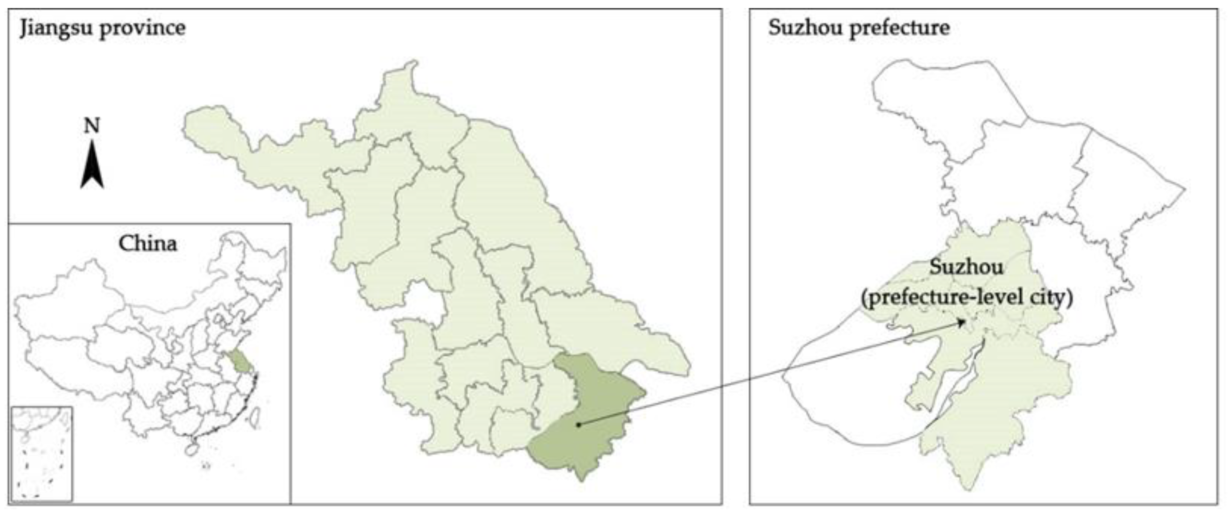
Figure 1. Location of the study area.
Land 11 01251 g001
Figure 2. Spatial layout of Suzhou in Song Dynasty (a), Ming Dynasty and middle and early Qing Dynasty (b), Late Qing Dynasty and the Republic of China (c). (Sources: (a) Map of Pingjiang, (b) Map of Gusu, (c) Newly Surveyed and Detailed Map of Suzhou and its Outskirts).
Land 11 01251 g002
Figure 3. Spatial layout of Suzhou in 1959 (a), 1976 (b). (Sources: Suzhou Natural Resources and Planning Bureau).
Land 11 01251 g003
Figure 4. Spatial layout of Suzhou in 1989. (Sources: Suzhou Natural Resources and Planning Bureau).
Land 11 01251 g004
Figure 5. Spatial layout of Suzhou in 2000. (Sources: Suzhou Natural Resources and Planning Bureau).
Land 11 01251 g005
Figure 6. Spatial layout of Suzhou in 2010. (Sources: Suzhou Natural Resources and Planning Bureau).
Land 11 01251 g006
Figure 7. Spatial layout of Suzhou in 2022. (Sources: Suzhou Natural Resources and Planning Bureau).
Land 11 01251 g007
Figure 8. Morphological change of Suzhou.
Land 11 01251 g008
Figure 9. Distribution of landscape features in Suzhou in 2000 (a), 2010 (b), 2022 (c). (Sources: Suzhou Natural Resources and Planning Bureau).
Land 11 01251 g009
Figure 10. The traditional garden (left) and modern park (right) in Suzhou. (Sources: Suzhou Landscape and Greening Bureau).
Land 11 01251 g010
Table 1. The structure of the urban landscape in Suzhou. (Sources: Suzhou Natural Resources and Planning Bureau and authors’ photographs.).
ZonesUrban Landscape FeaturesUrban Fabric
(a) The ancient city of Suzhou
Parallel water and streets in grid pattern; mainly traditional houses; many unique traditional gardens; part of the ancient city wall remains; mixed with some modern buildings; mixed land-use pattern
Land 11 01251 i001 Land 11 01251 i002
(b) Urban area constructed from 1949 to 1978
Mainly modern architecture; large number of enclosed, multi-story buildings in gated communities; mixed land-use pattern
Land 11 01251 i003 Land 11 01251 i004
(c) Urban area constructed after 1978
High-rise and multi-story residential buildings in gated communities; Many Skyscrapers and large commercial complexes; mixed land-use pattern
Land 11 01251 i005 Land 11 01251 i006
Table 2. Spatial types threatening the urban landscape of the ancient city. (Sources: Suzhou Natural Resources and Planning Bureau and authors’ photographs).
LocationIssuesUrban Fabric and Features
(a) Commercial complexes in the ancient city of Suzhou
Large-scale and regular form of modern buildings; centrally located; threats to the original skyline of the ancient city; different from the surrounding fabric
Land 11 01251 i007 Land 11 01251 i008
(b) Multi-story residential buildings in the ancient city of Suzhou
Threats to the original skyline of the ancient city; different from the surrounding fabric
Land 11 01251 i009 Land 11 01251 i010
Publisher’s Note: MDPI stays neutral with regard to jurisdictional claims in published maps and institutional affiliations.