1. Introduction
There is a long list of international literature on cultural heritage (CH) protection policies and on how to live with world heritage, why to protect and how to identify the benefits, how to evaluate the importance and identify which parts of the constructions must be protected, how and what to protect, what materials and methods to use, etc. [
1]. This paper focuses on the structure and development of a technical tool to be used for implementing various land policies. Such policies may include CH protection of mainly residential, privately-owned constructions of a particular CH interest that should be preserved and protected. Many countries have adopted strict regulations to protect such constructions or even whole historic settlements. However, the concept of the affordability and sustainability of such regulations for the property owners have not always been taken into account in all countries in the past. Although most countries have passed from centrally driven economies into a free-market economy where the issues relevant to the affordability and sustainability of regulations for the protection of private properties are high on the agenda, there is still much confusion in the general land policies implemented by various governments. Moreover, these protected CH buildings, despite their poor maintenance status, may continue to be used by their owners as the maintenance costs are not affordable to them, and the security of residents in terms of construction stability, for example, in the case of earthquakes, is usually not considered.
Greece is a country with long history and a large number of antiquities from a broad range of historic periods, which are classified into several categories depending on the construction time, such as pro-classic, classic and byzantine periods, as well as modern monuments, which may even include recent constructions such as of the 1960s or 1970s depending on their specific architectural or historic characteristics. Protected CH constructions of those categories may be declared either by the Ministry of Culture or by the Ministry of Environment and Energy. The current research and the tool under discussion is planned to be used mainly for modern CH buildings, usually single-family residences built at the beginning of the 20th century or later, or some post-World War II two-story constructions of a specific architectural or historic interest. By law, many CH buildings should be protected and preserved, and many future uses are forbidden, and for some others, only the façade should be maintained, and then new construction may be erected within that shell. The latter is well applied in Greece, while the majority of the remaining fully protected buildings are neglected and abandoned. Law has little or no concern about the economic and social impact on the property owners of such fully protected constructions (e.g., provides poor motivation policies, little or no compensation at all, etc.). Due to their restricted uses, there is limited buying interest for such constructions. In addition, most of these CH buildings are scattered within cities, and they very seldom can constitute a CH neighborhood. Protecting property rights as well as their value is an issue of vital importance for building trust and stability among society and for the smooth operation of property markets. Land values are increasing within the urban areas and a fair compensation for preservation of such CH constructions may become difficult to be provided to all property owners by the state. As mentioned earlier, maintenance costs for such highly regulated buildings are high (as the regulations may require specific and detailed interventions, materials and construction methods), while the permitted uses of such buildings are not usually profitable. Property owners usually cannot afford to be taxed for such non-profitable properties [
2] and cannot afford to maintain such constructions properly, thus resulting in a large number of abandoned and neglected constructions within urban areas that are later illegally occupied by certain vulnerable groups. There is an increased risk of accidents, and moreover, this situation contributes to the creation of dilapidated parts within the city. Examples of such ruined CH buildings are common in the cities and towns all over Greece, and unfortunately, some accidents following earthquakes have also been recorded. It is obvious that new and more efficient tools should be developed to successfully meet the challenge, really protect such buildings and integrate them in the economic cycle.
While affordable housing tools have already been adopted by some developed countries to deal with the increasing land values within urban areas, in Greece, governments until recently had poor housing policies (e.g., they tolerated either informal housing or long non-performing housing loans, a policy that severely affected the economy) [
3]. The development of a modern land tool which will be aligned with the UN Sustainable Development Agenda 2030 [
4] and the UNECE Policy Framework for Sustainable Real Estate Markets [
5] and will provide for affordable housing is an interesting emerging topic for research. As there is a global understanding that the market alone cannot satisfy the need for adequate affordable housing, the latter should be emphatically integrated into the general land development policy [
6].
In [
7], it is emphasized that special tools and regulations should be developed within the free-market economy in order to ensure the successful achievement of the sustainable development goals. Given that the management responsibilities for ordinary and major repairs and for the maintenance that properties require in order to maintain their economic function over time are expensive and that the state cannot easily afford such costs, social housing (in the sense that the state builds and owns the building) is no longer recommended. Instead, affordable housing tools should be investigated.
Following the political and economic change in many ex-Soviet countries with economies in transition, in the UNECE region, existing CH and land use planning and permitting regulations could not operate efficiently due to a number of reasons (e.g., rapid internal and external migration, lack of housing policy, inefficiency of land administration projects, lack of personnel, high costs/permitting fees, long permitting times, bureaucracy, corruption, conflicts, natural disasters, poverty, etc.) [
8]. This has resulted in extended informal development, usually of self-made residential buildings of up to 3–4 floors, which had a significant social, environmental and economic impact, including the planning, protection, and preservation of CH buildings, the protection of sites of natural beauty, etc.
Some of these informal constructions in the UNECE self-made cities may comply with construction standards for stability, energy efficiency, ventilation, etc., but many of them, although built by experienced builders, do not comply with standards, and thus their actual economic life is in fact limited, and to a great extent, it may become preferable and more profitable to replace them instead of trying to improve them; they are expected to serve the housing needs of the current and the next two generations at a maximum. Such constructions are currently formalized, registered and integrated into the economic cycle; however, there is a need for future urban reforms, for creating more urban green spaces, and most importantly, for allowing increased urban densities to host more urban residents and avoid further urban sprawl in the future. For such reasons, it is anticipated that most of these formalized constructions will be replaced in the near future. This may happen either through the market supposing that the private sector may show interest, or through a land consolidation and readjustment project. However, large urban land consolidation projects are complex, costly and long, and will create much social unrest, so it is not really suggested that such a reform will be initiated for the whole city; instead, this can be done incrementally and voluntarily in small blocks. The methodology and the tool under development are intended to serve this function.
In parallel, many countries globally try to improve their cadastral systems by implementing research to add a third dimension (e.g., some European cadastral agencies, for example, the Dutch [
9] and the Spanish cadastre [
10], and some other Asian cadastral agencies) in an effort to provide a tool for good decision making to achieve the “best use” of the urban and serviced land and its extension, as well as the further development of property rights and the land’s market in the third dimension. Some cadastral agencies even conduct further research for providing this information in various time periods (the fourth dimension) [
11] in order to facilitate the complex market needs and emerging requirements within urban areas.
As mentioned above, some countries try to initiate formalization projects in order to integrate all the informal real estate (and informal urban settlements) into the property registration systems, clear out the property rights, formalize the property market and introduce planning systems in the already informally developed urban settlements, in order to avoid further urban sprawl and facilitate further 3D urban development [
12,
13,
14,
15].
The objective of this research was to develop a technical tool and a methodology that serve the need for current and future voluntary and small-scale urban land reforms, especially through the identification of existing CH residential buildings (as mentioned above), vacant or underused urban land parcels, and existing property rights. By providing a Floor Area Ratio (FAR) bonus based on the well-known value capture [
16,
17,
18,
19,
20,
21,
22] principle, this may allow for additional development rights beyond the permissible limits. New and energy-efficient construction may be built to host all previous property owners, following a consolidation of land parcels and readjustment of property rights, as well as the newcomers, who will be the beneficiaries for affordable housing as defined by the state. Parts of this tool are developed experimentally, through research project 5dMuPLIS within the framework of a bilateral Greek–Israeli R&T cooperation [
23,
24], to be used for incremental urban upgrading such as the self-made UNECE cities, following the formalization of informal development, or in general cities that may now be formalized and have ratified city plans, but initially had been developed following an extensive informal urban sprawl, as with most cities in Greece [
3,
12,
25,
26]. The tool development project was financed by the EU and the Greek government and was compiled.
The value capture instrument has long been included in Greek Law in an effort to provide the right to the owners of CH-protected residential buildings within urban areas to use the remaining development rights, if any, (according to the valid FAR in the city plan) in any land parcel of the city or of another city/town that they may happen to own another land parcel as additional rights to the valid FAR there; such development rights could also be transferred. However, this law has not been implemented until 2022, as increasing the valid FAR within a ratified city plan was judged as unconstitutional by the Council of the State. Recently, new legislation has been prepared so that such rights may be transferred to a specific landbank. The scope of this research is not to investigate policies and instruments exclusively applicable for CH preservation, but to develop a methodology and a tool in order to enable governments to implement self-financed, voluntary, small-scale, fit-for-purpose urban land reform projects in general, which among other policies, may also combine CH protection policy initiatives. Additional instruments and policies for CH protection projects that cannot be served by this tool may be used in parallel. The suggestion of our research is that the urban density in the self-made cities should be increased anyway to gradually create more compact cities as an adaptation and mitigation measure towards climate change e.g., to avoid long commuting costs and gas emissions. Therefore, it is proposed that for social and environmental reasons, such constitutional restrictions should be overcome or interpreted differently by the Council of the State to allow for a moderate increase in FAR.
The tool is expected to be used for small-scale and incremental, voluntary urban regeneration projects that may also include residential buildings being listed as “protected”, in an effort to achieve the “best use” of land and allow for new construction and for energy saving measures, modern urban planning and planning for affordable housing provisions while preserving CH constructions. It should serve and engage both the public and private sectors (state authorities, municipalities, property owners and professionals) and be applicable in various geographical regions with similar characteristics (e.g., both in developed and developing economies/markets and both in formalized and informal urban settlements). It should serve various self-financed, small-scale land management purposes, various land policies, and land reforms (such as property registration projects in four dimensions using modern technology, planning, land consolidation and land readjustment, as well as affordable housing provision) with increased transparency.
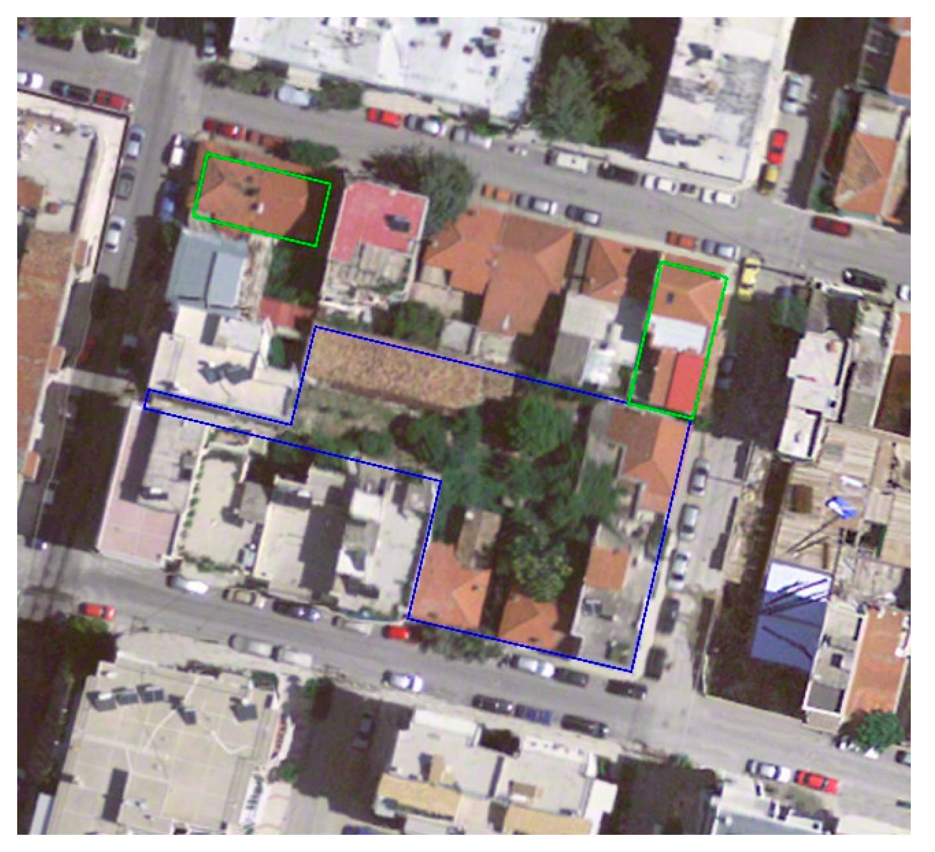
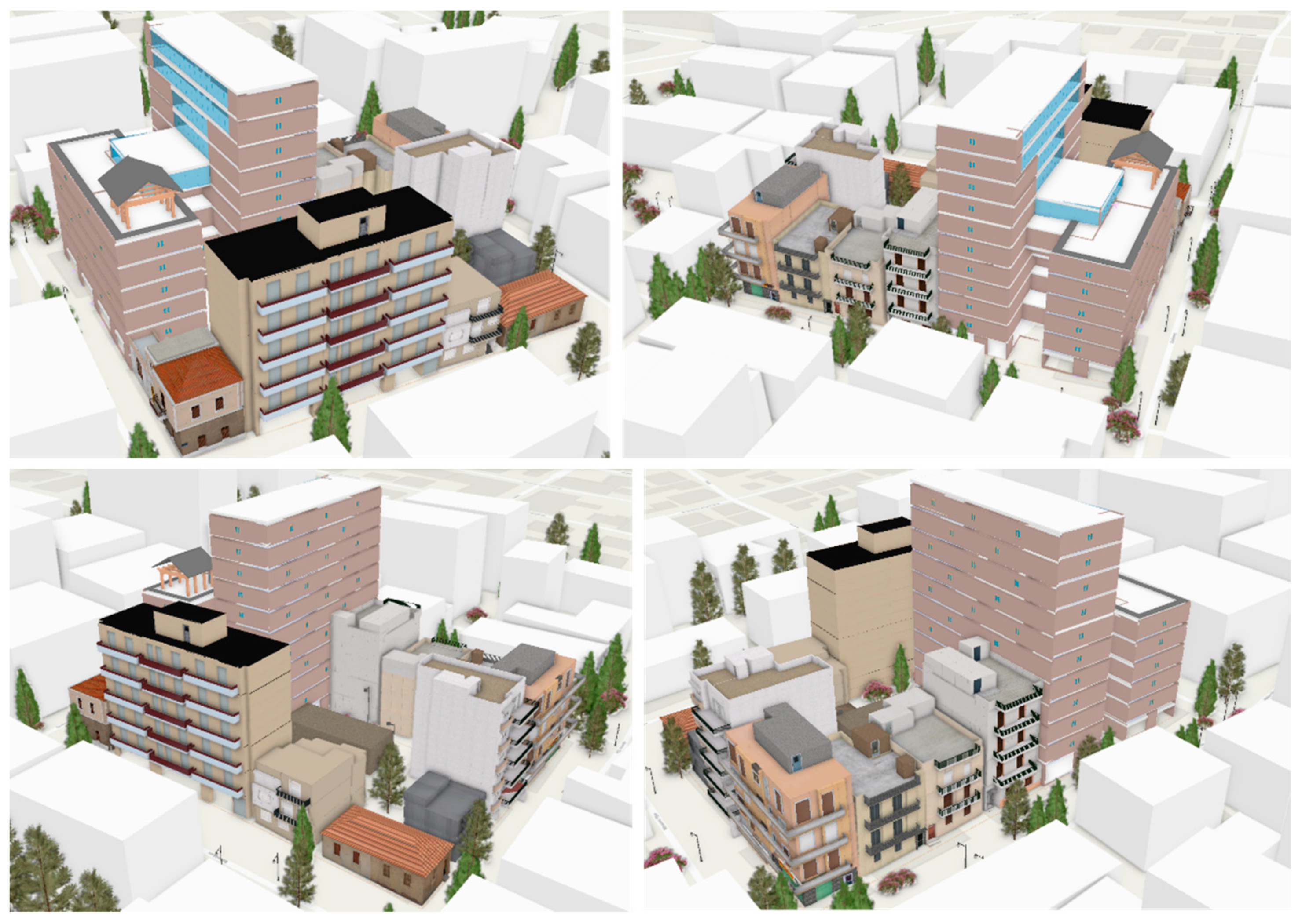
In this paper, the methodology adopted for the development of the technical tool is presented in terms of 3D modeling at various scales, the valuation of properties and metadata enrichment, as well as the readjustment of property rights and the provision of affordable housing. Initial data collection (outlines of building footprints, elevation data, building facades) was accomplished photogrammetrically with SfM, and the 3D models were produced by ArcGIS CityEngine (in GIS environment) and then were connected with BIM. Finally, a case study for the urban regeneration of a small block of plots, including the CH preservation of some buildings, as listed by the responsible Ministry, in a neighborhood in Athens, Greece, is presented, and the conclusions of our research are discussed.
2. Methodology
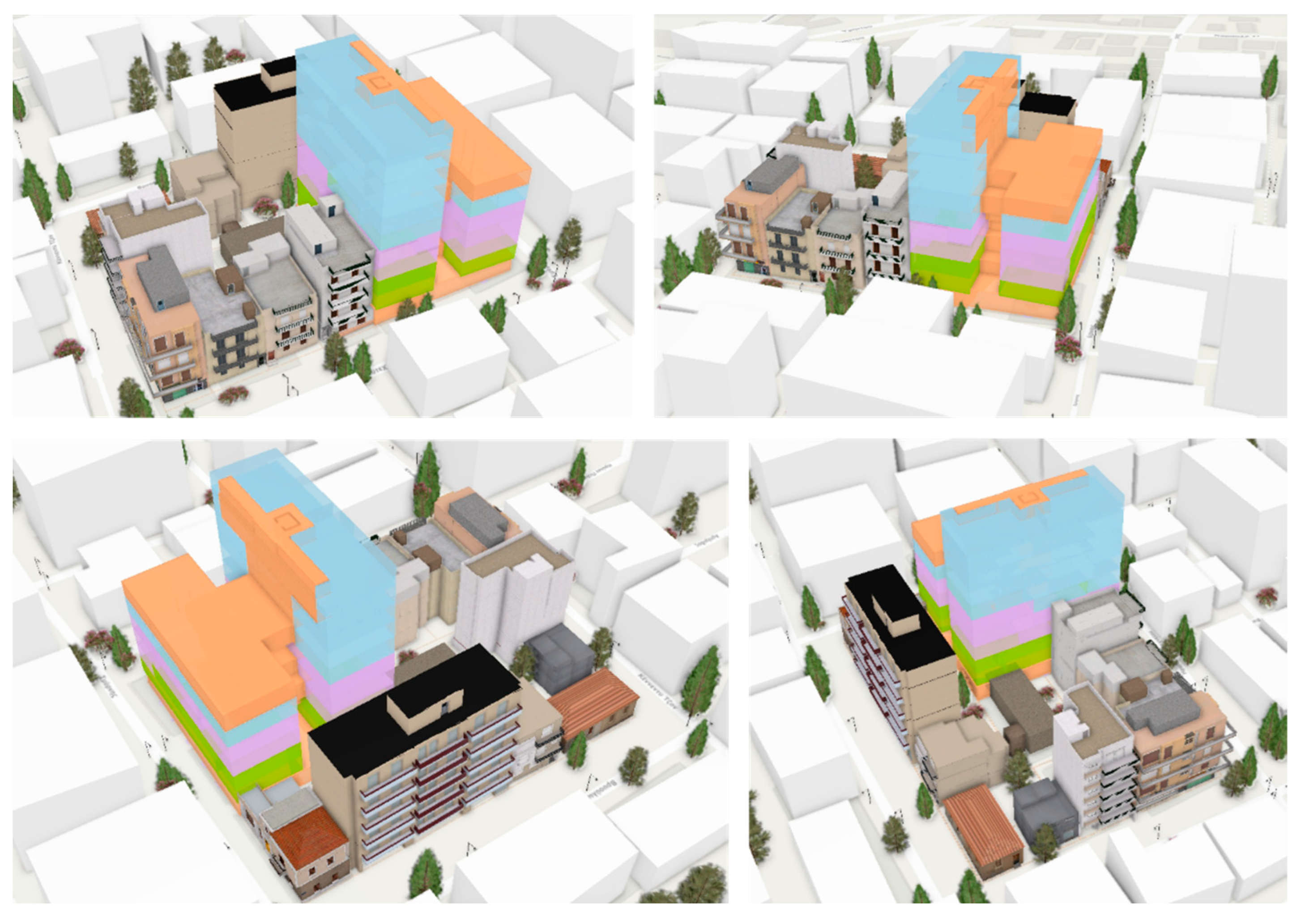
In this section, the proposed framework that may lead to the implementation of urban regeneration, including planning for affordable housing provisions and the preservation of CH privately-owned, residential constructions, is described. The proposed methodology is suitable for various types of applications, including 3D cadastre and land administration, urban planning, land management reforms against disasters, civil development, real estate management as well as rural and urban settlement upgrading, and can be used by the administration, provided that professionals in the fields of photogrammetry and land administration are involved in the process. As mentioned earlier, to use this tool in Greece, a legal reform is needed to allow for an approximately 10–15% increase in FAR for social and environmental reasons. The amount of the increase should be adjustable to the relevant needs and international trends. It is also possible to use this tool in other regions out of Greece with similar characteristics, e.g., in the self-made cities in the Balkan region and the UNECE region in general, where constructions are built informally in unplanned areas, without permits or exceeding permits, and many are substandard, with up to 3–4 floors and with land parcels that are relatively small. There is also a lack of urban public green spaces. The construction characteristics have large similarities as many residents of Eastern Europe have moved to Greece as economic immigrants, worked and gained experience in the construction sector in Greece, and brought back experience and labor savings. What is needed is first to further develop the local private sector in such countries, improve professional ethics and reliability issues, and provide for the necessary legislation. Moreover, improved population and socio-economic statistics will allow for a good estimate of the target group of beneficiaries who will be given access to affordable housing. A careful identification of old residential buildings and those of a particular cultural value that may be subject to a change in use that should be listed as ‘protected’ or as CH buildings is also fundamental. The following methodology includes the creation of 3D models of the existing situation as well as 3D models/BIM of the future constructions following the reform, at various scales, the valuation of existing properties and an estimate of the value of the future properties, the enrichment of the generated 3D models with metadata, and the readjustment of property rights along with affordable housing policies, as well as CH preservation and protection policies.
The designed model includes the following steps: a discussion for an agreement/partnership among the property owners, the involved authorities and the developer team; the creation of 3D cadastral map/tables of the area under study by a private land surveyor of the developer’s team; the estimation of the market values of the existing property rights by a private valuer of the team; the identification of the “protected” buildings, if they exist, by the private surveyor, as listed by the responsible authorities; the identification of vacant or underdeveloped parcels that can be consolidated and redeveloped by the developer; the signing of the agreement/partnership; an increase in the FAR by a state decision; the compilation of the urban regeneration study by a planner/architect of the team; the demolition of any old buildings whose economic life is over, as agreed between the developer and the property owner; the consolidation of parcels by the surveyor; the construction of the new apartment building(s) by the developer; property valuation of the new property units by the valuer; the creation of a new cadastral map and the redistribution of property rights by the surveyor to the previous owners, the developer/team and the beneficiaries for affordable housing (the low-income target group, as defined by the responsible authorities) according to the signed agreement/partnership.
2.1. Creation of 3D Models in Various LoDs
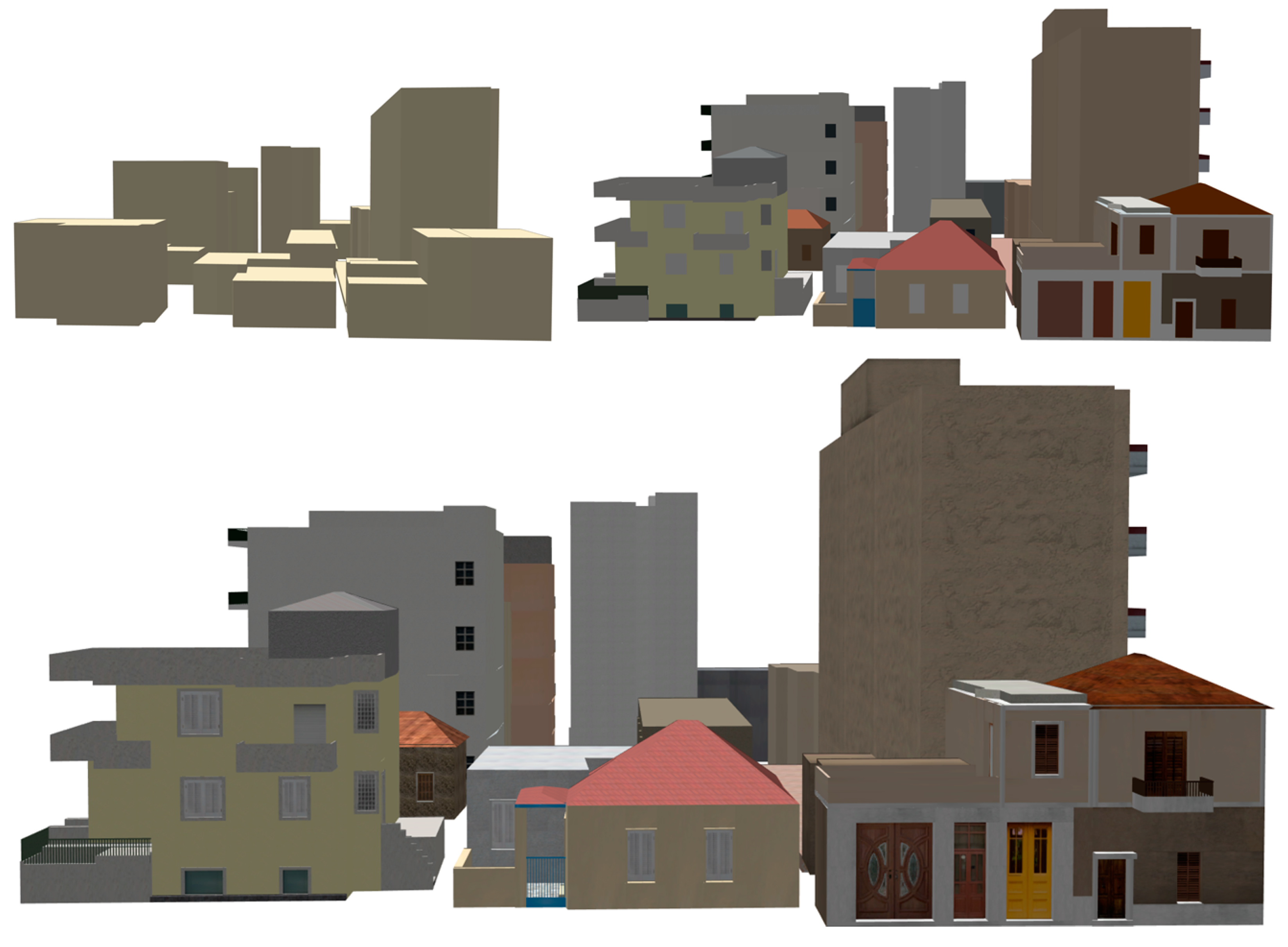
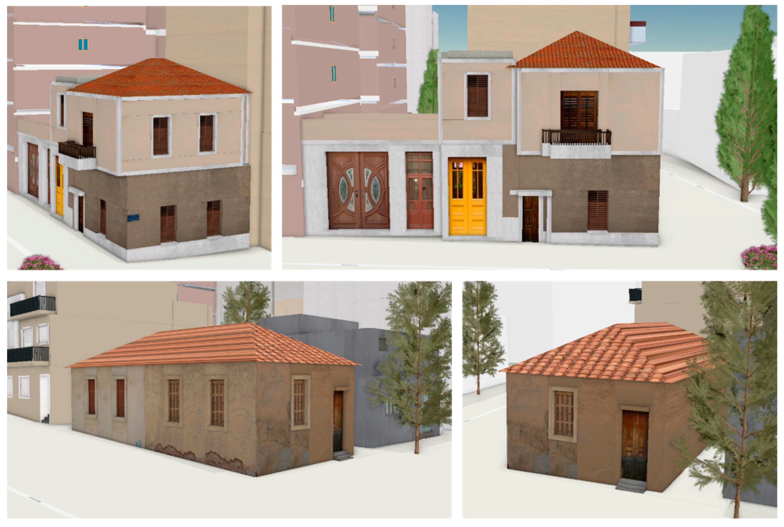
A fundamental part of the proposed methodology is the 3D modeling of the existing buildings in various Levels of Detail (LoDs), as well as the 3D modeling of the future constructions following reforms. Apart from providing the essential 3D information for the compilation of a 3D cadastre, the complete 3D modeling of the existing situation is also essential for (a) the identification of the “unused or underused” private or public urban plots for the implementation of the urban regeneration process together with the affordable housing scenario; along with (b) the identification of possible residential buildings of high cultural value that need to be listed as “protected buildings” in order to be covered by CH protection regulations.
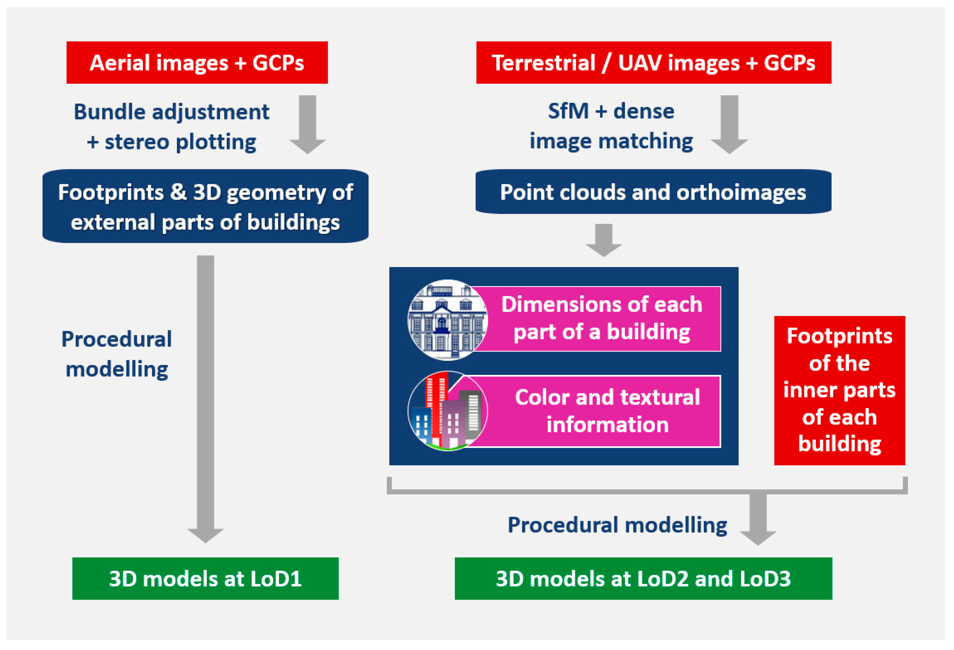
The concept of LoD not only facilitates and accelerates the efficient visualization of large scenes, but also provides models of various scales according to the requirements of the various users of a multi-purpose Land Information System (LIS). The proposed procedure for the creation of 3D models of buildings for the existing situation at various LoDs is illustrated in
Figure 1. The differentiation of LoDs, as proposed by CityGML [
27] and implemented in [
24,
28], is used.
For the generation of high-accuracy 3D models for the existing situation, a combined use of aerial and terrestrial or low-altitude UAV oblique images along with ground control points (GCPs) is necessary; conventional photogrammetric techniques (i.e., bundle adjustment and stereo plotting) using stereo pairs of aerial images, in combination with Structure from Motion (SfM) and Dense Image Matching (DIM) techniques using overlapping terrestrial or UAV imagery, as proposed in [
24], may be applied. The outputs of the aforementioned procedures can be used for the creation of 3D building models in four LoDs. Specifically, the LoD0 model, that is, the Digital Surface Model (DSM), is created by the mass points defining the ground and the points on the top of man-made constructions, and LoD1 models (i.e., prismatic models with flat roofs) are generated using the building outlines and footprints, which may be stored using the ESRI shapefile format. Whereas LoD0 and LoD1 3D models are created solely through the processing of aerial imagery, the creation of 3D models in LoD2 and LoD3 requires the use of terrestrial images or UAV images as well; the derived point clouds and orthoimages may be used for the extraction of metric, textural and color information. All this information can be used for the creation of multi-scale building models either through procedural modelling [
24,
28] or in the form of Building Information Model (BIM). It is proposed that LoD1 corresponds to the 3D model of a building, whereas the LoD2 and LoD3 models represent each inner part of a building (i.e., apartment, common area, storage area). The footprints of the inner parts of each building may be created based on information collected from data derived from construction permits that exist in the planning office or from direct measurements with the help of the owners.
2.2. Valuation of Properties
The valuation of properties, that is, the estimation of their market values, is the next step of the adopted methodology; it has to be prepared in accordance with the rules and guidelines of the International Valuation Standards (IVS) Standard 1 [
29], taking into consideration the principle of the “highest and best use” [
30]. The market value is defined in accordance with the International Valuation Standards Committee as the estimated amount for which a property should be exchanged on the date of valuation between a willing buyer and a willing seller in an arm’s length transaction, after proper marketing, wherein the parties have each acted knowledgeably, prudently and without compulsion [
29]. The market value is considered to be the best price reasonably obtainable by the seller and the most advantageous price reasonably obtainable by the buyer, and relies on the following basic assumptions:
the two parties (seller and buyer) act knowledgeably and are willing to advance in agreement;
the two parties are well informed, prudent and act based on their personal interest;
the property is exposed for sale in the market for a reasonable time period;
the price is paid “in cash” or with a financial settlement that can be considered as “in cash.”
The market value of the subject properties should be assessed, taking into account their current and their potential condition, assuming vacant possession. In order to determine the market value of the subject properties, an appropriate method, such as the Sales Comparison Method or the Residual Method, may be adopted. In order to complete the valuation report, the surfaces of the land plots, the surfaces of the buildings and properties, and the characteristics of the properties, such as the floor, use and co-ownership ratio on the plot, have to be examined. In addition, an inspection has to be carried out in the field. Furthermore, thorough market research has to be carried out in order to determine all the critical factors that affect the value of the properties, such as property market trends, demand and supply for residential units in the area, sale duration, vacancy rates, etc.
2.3. Metadata Enrichment
For the further development of the 3D models in a fourth dimension, i.e., “time” (the 3D cadastral modeling and valuation of the existing properties and the future situation) and a fifth dimension, i.e., “scale” (the scale reflects the various LoDs), the models need to be enriched with supplementary data and metadata, necessary for the implementation of the readjustment of property rights and planning for the affordable housing scenario and the built heritage protection. The enrichment of the models with such data and metadata is achieved by creating an internal system database and an external database that is linked with the internal one through common fields.
Each 3D cadastral model that represents an apartment, a common area or other structural or cadastral objects has to be given various attributes along with a unique identifier. The unique identifier (ID) adopted by the tool consists of twenty-four alphanumerical characters and identifies each structure among all other structures in Greece. For instance,
Table 1 shows the metadata that are proposed to be stored in each model, which may be a KML-COLLADA file, whereas
Table 2 shows the proposed metadata schema in the internal database of the shapefiles. An external database, including information concerning the buildings, may also be created. This database should include the following data types [
9]:
spatial data (geometry and texture), including both the 2.5D footprints that refer to properties, buildings and land parcels and 3D textured models;
time (period of validity of property rights and buildings);
semantic (cadastral) data.
This database is proposed to be connected with the records of the shapefiles using one common field, the ID, which is unique for every apartment or building. In this way, every apartment or building is connected with all the available metadata.
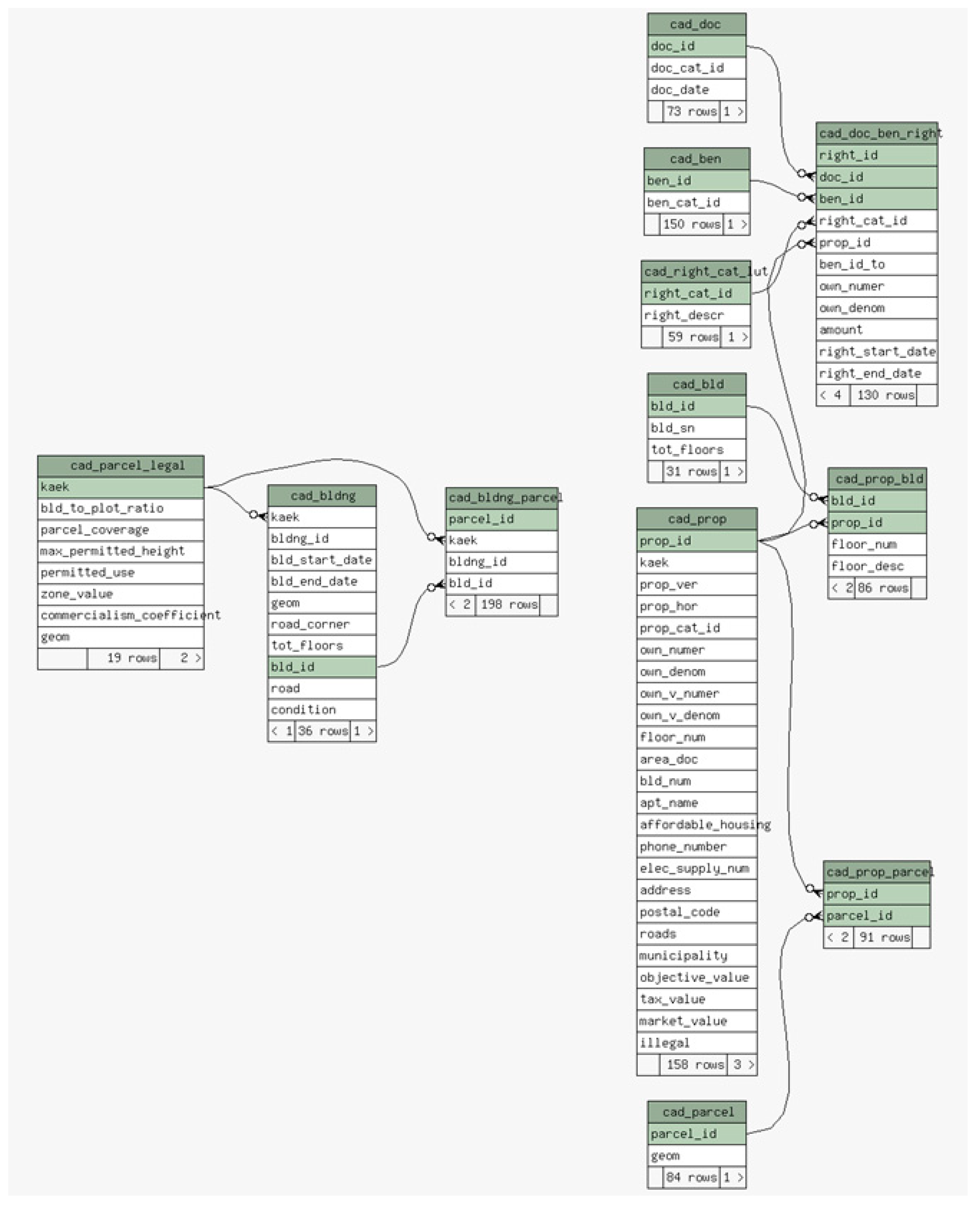
Figure 2 illustrates the external database schema adopted by the tool, including the tables that compose it, their fields, the primary keys and their relationships.
According to the concept adopted, the land is divided into parcels, so that each piece of land is connected with only one parcel. The parcels are described in the table “cad_parcel”. Each parcel may have property units with attributes described in the table “cad_prop”. For each property unit, there are registered rights (e.g., percentage of ownership) which are created based on legal documents; these documents are described in the table “cad_doc”. The type of each right (e.g., easement) is described in the table “cad_right_cat_lut” and each right must refer to a beneficiary which is described in the table “cad_ben”. The table “cad_doc_ben_right” is used to correlate the information between the property unit, the right, the document and the beneficiary. The table “cad_prop_parcel” relates the property units with the parcels, since one parcel may have many property units. The table “cad_bld” describes the buildings, and the table “cad_prop_bld” joins the buildings to their properties. The table “cad_parcel_legal” extends the attributes of each parcel in order to describe legal elements valid for the land parcel (e.g., building-to-plot ratio, maximum permitted height, etc.), urban planning or architectural data (e.g., land use), real estate values (zone value, tax and commercial values), etc. Each parcel may have a number of buildings with attributes that are described in the table “cad_bldng” (e.g., construction date, number of floors, condition); this table includes metadata that refer to each building, so that 3D models in LoD1 may be enriched with them. The table “cad_bldng_parcel” serves for the linking of property rights with the buildings, for the enrichment of the 3D models in LoD2 and LoD3 with metadata.
2.4. Readjustment of Property Rights and Parallel Affordable Housing Provisions and Preservation of CH Buildings
The readjustment of property rights towards affordable housing provisions and the preservation of CH buildings, proposed within this article, aims to enable:
small-scale urban regeneration, by proposing a scenario concerning the identification of unused or underused urban plots and the demolition of old buildings, followed by the merging of the involved parcels and the creation of a new building and the surrounding space;
an affordable housing scenario, by providing a number of affordable apartments in the new building to those with a household income at or below the median; and
a policy that protects buildings of high cultural/historical/architectural value, privately-owned, combined with a change in use of those buildings (such as cultural center, library, etc.) and a consequent change in ownership of these CH buildings from privately-owned to municipal or state-owned.
The tool may be used only for redevelopment and affordable housing provisions if there are no CH buildings in the block or for any other relevant land reform. The tool does not suggest the policy that each government should adopt; it only enables the implementation of the selected policy.
Taking into account the aforementioned policy, the readjustment of property rights includes the following steps:
Informing the property owners (individuals or the state) about the benefits and the incentives of a regeneration project with a readjustment of property rights, as well as a policy of protecting buildings of high cultural value and ensuring their voluntary participation; the identification of the appropriate blocks of plots for the implementation of the regeneration scenario; the identification of the existing buildings of high cultural/historical/architectural value; the identification of self-made constructions that their economic life is over; the creation of a 3D cadastral database that should be updated with all the necessary information that allows for a fair property valuation; changes in the building regulations and increases in the FAR; the estimation of the market values of the existing and future constructions as well the value of the property rights, accordingly; the consolidation of the allocated parcels; the demolition of the old constructions and planning of a new building and the surrounding area with the increased FAR by a state decision permit; the establishment of an agreement/partnership between a developer (to finance the design and construction of the new building in a controlled-profit manner by agreeing that a certain number of property units will be given at affordable prices to a certain target group defined by the state) and the current land owners; the redistribution of the property rights of the owners to the newly built units.
The new right holders should be:
the previous right holders (both those who owned the old buildings selected for demolition as well as those who owned buildings listed as “protected CH buildings”), who will be replaced and receive new units of a slightly higher value than the one they had prior to the reform, in order to ensure their voluntary participation and their resettlement costs for the period of reconstruction; owners should by all means receive more than what they would normally if they would make a usual agreement with a developer;
the developer, who will finance the new construction and work to develop the new units; the developer should receive at least as much profit as a usual standard project;
the target group beneficiaries of the affordable housing policy, who will be low- and low-to-middle-income households, as defined in the state list.
4. Conclusions and Discussion
In this article, a general technical tool for the implementation of a small-scale, voluntary urban regeneration process through parcel consolidation and the readjustment of property rights is proposed, and a detailed, hypothetical case study is given, which combines the creation of a 4D cadastre (3D geometry of the existing situation plus a future scenario), property valuation, and the planning for and dissemination of affordable housing for the preservation and protection of privately-owned, CH residential small-size buildings.
The presented affordable housing and CH preservation hypothetical scenario was tested and proved realistic and financially sustainable, and the derived results have shown that the proposed method is very successful and fits with the current international best practices. Parcel consolidation and the readjustment of property rights is a method broadly used in Greece for land development and small-scale urban regeneration projects. Developers in the private sector and property owners in Greece are willing to come to partnership agreements so that the landowners will contribute the land and the developers will undertake development costs (both soft and hard costs, professional profit, etc.); at the end of the project, they share the new property units according to the agreement; for the agreement, they take into consideration the current value of the land parcels, all generalized costs for the project, including the developer’s profit, the expected market data at the time the construction will be finished, and how much the new property units are expected to be sold. A similar experience is currently being developed in other neighboring countries. The new issue which is introduced here is the proposal for a FAR increase in Greece for social (affordable housing) and environmental (CH preservation) purposes. The new building code in Greece already allows for an increase in FAR for climate change interventions in the new construction and planning of the consolidated parcels. In some countries of the greater Balkan region, it is mandatory that FAR is increased, e.g., in North Macedonia, all new urban constructions should not be less than 30 floors.
The tool does not introduce any new valuation methodology. Valuation of the old constructions was conducted according to international standards and common practices in Greece. The case study is indicative and hypothetical. For this reason, there is no need for the provision of detailed financial data. Similarly, the paper does not provide detail on the construction standards for the energy efficiency of the new constructions. Such information is included in the new building code of Greece. The costs for all of that are included in the estimated generalized construction cost per square meter. If the tool has to be applied in practice, a new, contemporary valuation must be made that will take into account the current market data (valuation of land parcels, construction costs, valuation of new construction, etc.), the post-COVID-19 situation and the impact of the war in Ukraine on the energy prices and consequently on the costs of construction.
This technical tool is structured to work efficiently for small-scale, voluntary, urban redevelopment projects; the scalability of this tool is not investigated and suggested. Experience from large-scale urban land consolidation and the readjustment of property rights projects for planning purposes shows that such projects are not easily managed, last long and are costly [
26]. However, by the compilation of the national spatial data infrastructure in Greece, times and costs for such projects will be reduced in the future. Property owners will always be expected to contribute both land and money for all the necessary provisions, though. Apart from supporting affordable housing policies within the framework and the rules of the globalized economy, the proposed technical tool also supports the good governance of cities, as it facilitates the incremental creation of local geospatial data infrastructure necessary for all the types of services for the management of smart cities, such as security, transportation, disaster management, etc. In addition, innovative technical solutions were proposed to be used for the updating of geospatial databases, such as for data capturing (e.g., dense image matching, SfM, procedural modeling).
The affordable housing scenario supports solid stability as well as the inclusive and increased participation of the private sector, the property owners, the vulnerable groups and the citizens in general in decision-making procedures, by supporting the development of voluntary procedures and by allowing the development of fair win–win solutions for the state, the private sector, the property owners and the vulnerable groups. Moreover, it can support self-financed, small-scale projects for urban regeneration and the creation of green public spaces within urban neighborhoods.
The tool is not suggested to be used for large-scale urban land consolidation and property rights readjustments. First, it is almost impossible to achieve an over 50% agreement for such a large-scale voluntary project; it has to be obligatory and financed by the state. Experience from obligatory land consolidation projects in the rural sector in Greece as well as in other EU countries has proved that they are costly, complex, long-lasting and introduce a lot of conflict, as many land owners have objections in all phases of the project. Therefore, it is preferable to work with small-scale, voluntary, self-financed projects that can be completed in a relatively short time. In such projects, the role of the state is to set the rules and monitor. It also should prepare the lists of the beneficiaries for affordable housing or for CH buildings.
In addition, urban regeneration supports the upgrading of cities and the gradual development of more compact cities, characterized by increased urban sprawl or informally developed settlements, and may be also applied in other countries with increased challenges due to unplanned informal development and substandard constructions that anyway are not expected to have a long economic life. Finally, the preservation of residential one or two-story CH buildings and their protection according to heritage protection regulations, along with a possible change in use (e.g., from residential to cultural centers or municipal buildings) may lead to the cultural and aesthetic upgrading of the areas. Additional tools for the CH protection of such constructions may also be implemented in parallel. However, this was not within the scope of this research. Within this concept, it may be said that this research contributes to a successful implementation of several SDGs of the UN Sustainable Development Agenda 2030 such as SDG 1 (No poverty), SDG 6 (Clean water and sanitation), SDG 10 (Reduced inequalities), SDG 11 (Sustainable cities and communities), SDG 13 (Climate action), SDG 15 (Life on land), SDG 17 (Partnerships for the Goals), as well as of several Targets and Indicators.


 ,
, 


