Article

Geographical Data and Metadata on Land Administration in Spain

by
Gaspar Mora-Navarro
*,
Carmen Femenia-Ribera
,
Joan Manuel Velilla Torres
and
Jose Martinez-Llario
Department of Cartographic Engineering, Geodesy and Photogrammetry, Universitat Politècnica de València, 46022 Valencia, Spain
*
Author to whom correspondence should be addressed.
Land 2022, 11(7), 1107; https://doi.org/10.3390/land11071107
Submission received: 19 May 2022 / Revised: 9 July 2022 / Accepted: 14 July 2022 / Published: 19 July 2022

Abstract

:
Spain has a tax-oriented cadastre with legal data about properties (ownership, rights, liens, charges, and restrictions) recorded in a separate property rights registry (henceforth called land registry). This paper describes the Spanish cadastre and land registry by focusing on the new coordination system set by Law 13/2015. Since Law 13/2015 came into force in Spain, cadastral cartography is the basis for knowing where land registry units are located. The new coordination system sets a procedure to update the cadastral parcel boundary of a property when it does not match with reality. In these cases, the free-profession land surveyor sends the new property boundary through the Internet in order to update the corresponding cadastral parcel boundary. Currently, neither the cadastre nor the land registry has considered storing geographical metadata for each property boundary in a standardised way. As boundaries show the limits of individual properties, boundary metadata denote the accuracy with which such ownership rights are indicated. We propose that, for these boundary update cases, the Spanish cadastre also allows the upload of qualitative and quantitative instances of the data quality class of the Spanish Metadata Core standard, and this information be available for users, for example in an XML file. These metadata provide justified information about how the boundary has been obtained and its accuracy. Software has been developed to manage this metadata of each property boundary, in order to allow us to evaluate whether or not this information is useful. We present the conclusions about some real-life tests of property delimitations.

1. Introduction

Land administration must be recognised as critical for the broader socio-economic and environmental benefits that effective land administration has [1]. An effective land administration management system facilitates land registry unit transactions, avoids legal disputes, facilitates the granting of mortgages [2], and supports sustainable development [3]. By documenting land rights and their boundaries, land administration protects private property, which has been identified as a major criterion for economic development [4,5].
Nations with a clearly judicial cadastre have always used precise maps as a basis for the land administration model, which is the case for the Netherlands, Germany, Australia and Switzerland. In countries with a tax-oriented cadastre such as Spain [6], Colombia, Uruguay, Brazil, Paraguay, Portugal or Poland [7], legal certainty is provided by the land registry [8]. In tax-oriented cadastre countries, coordination between the cadastre and the land registry has to be perfect. Coordination implies fast data interchanges between the two database systems, and not duplicating information. For example, if the land registry changes a property owner, the cadastre must also be changed, and vice versa.
Land administration is complex because it involves technical and legal data and many professional people’s profiles. Land administration means to set the relationships between land and people, and their management must be dynamic to reflect the continuous changes that land undergoes [9]. Property boundaries can change due to constant land development and re-surveys using more accurate surveying equipment [10].
The Land Administration Domain Model (LADM) was created, an initiative of the International Federation of Surveyors (FIG) in collaboration with the United Nations UN-HABITAT programme. This model is based on a document entitled Cadastre 2014 [11]. It is a project that began in 2008, and the initiative has been accepted by ISO by constituting Standard ISO TC 211 19152:2012.
The LADM manages both cadastre and land registry data. The model even enables the creation of 4D cadastres [12,13]. Its data model is based on four separate packages: Party, Administrative, Spatial Unit, and the Surveying and Spatial Representation sub-package. A detailed explanation of the LADM can be found in [14].
The LADM has a huge impact on the specialised scientific sector. Since it appeared, there has been considerable movement in land administration domains towards the model being implemented [15]. The LADM is a basic conceptual model that can be extended to the specific characteristics of a given country; for example, more recently, we cite [7,15,16,17,18,19,20].
The application of the LADM in developed countries, where expensive made-to-measure software ownership developments exist, is more difficult than in developing countries, where the first land administration works have begun [21]. In Spain, the cadastre employs the SIGCA3 software, while the land registry resorts to Experior and Geobase software. These are all independent systems, which makes the complete application of the LADM model difficult. Different databases and systems between the cadastre and land registry spell a lack of coordination. For example, in Spain, as a declaration in the cadastre is mandatory, buyers of properties are forced to notify the cadastre that they are the new owners. Nevertheless, registration in the land registry is voluntary. The result of this design is a lack of coordination because there are different property holders in the cadastre and the land registry. Further action involves programming data exchange interfaces between systems, where LADM is also a model that can be used to improve interoperability [22].
The research presented herein is about the lack of standardized, available geographical metadata in both the Spanish cadastral cartography and the Spanish land registry. In November 2015, the Spanish Law on Mortgages was modified (Law 13/2015) by introducing important concepts about property delimitation and coordination between the cadastre and the land registry. Now, the cadastral maps are the official cartography of land registry units. We show a brief description of the cadastre, the land registry, and, in depth, the most recent Spanish laws from the viewpoint of coordination, geometries and their metadata. Shortages and latest advances are stressed in terms of the geographic metadata of land registry units. For whatever reason, neither the land registry nor the cadastre saves standardized metadata about the boundaries of land registry units. Both institutions register documents about boundary delimitations, but these documents are internal and are not publicly available. We propose that the Spanish cadastre should allow land surveyors to introduce the qualitative component and quantitative component of the data quality class of the Spanish Metadata Core (NEM) standard https://gisserver.car.upv.es/html/NEM-Spanish-metadata-core.pdf (accessed on 13 July 2022) when a property boundary is being updated. The NEM is based in several standards, mostly in the ISO 19115, but also in the Dublin Core and others [23]. The NEM also exists according to the Infrastructure for Spatial Information in Europe (INSPIRE) metadata specification. The data quality class describes the process steps followed to obtain the boundary and the final accuracy. Then, a few cadastral parcels will have metadata about their boundaries, but only those coordinated according to the Law 13/2015 coordination process. In these cases, there will not be uncertainty about the boundary data quality or spatial accuracy, which can avoid inappropriate uses [24,25,26].
To evaluate whether or not metadata about property delimitations are useful, this research presents a prototype of software (a QGIS plugin). This software was created to emphasise that these metadata are important, conferring security to the real-estate trade, and it is important to make them available as a public service. The prototype includes all the geographic data and metadata generated during the delimitation of a land registry unit or property unit in the land registry, through topographical work conducted by a free-profession land surveyor. The prototype was installed in two land registries and was tested by delimiting eight properties. We present in this research the conclusions of all these tests. You can find the non-protected data and metadata of the database in the geoportal GeoDelProp https://gisserver.car.upv.es/geodelprop/ (accessed on 13 July 2022).
Our approach is only applicable in developed countries, where most of the land has been registered with formal land administration services. The cost of the updates of the land registry units is paid by the private sector, usually landowners, because the updates are necessary due to the fact that land registry units are going to be involved in legal transactions, and the current boundary of the land registry units in the cadastre do not coincide with reality. The update cost for each update is easily over EUR 1000 in Spain. In developing countries, most people cannot afford this cost and cannot register their land, for this and other reasons. The majority of these people are poor and the most vulnerable in society [27]. It is believed that 70% of the world’s population has no access to formal land administration services, and has no security of tenure [28,29]. In these scenarios, Fit-For-Purpose Land Administration must be applied. Fit-For-Purpose focuses on data acquisition, recording, and delivering access to these records. The goal is to benefit more people by gathering a set of minimal information at an affordable cost, covering more land in less time, and gradually improving the quality and quantity of information and land services [30]. The Fit-For-Purpose Land Administration model is being applied in countries such as Nepal [31], Ghana, Kenya, and Namibia [32].

2. Spanish Laws on Land Administration

In Spain’s recent history, a major step in legislation coordination was taken in 1996 (Ley 13/1996), which involved including the national cadastral reference in Public Deeds of sale and similar documents. The national cadastral reference is a unique identifier assigned by the cadastre to identify cadastral parcels, and this legislation is proving most effective. The national cadastral reference thus became the nexus to link Public Deeds of properties and cadastral boundaries. Since then, when owners decide to write their rights in the land registry with their Public Deeds, the land registry unit of the property is linked to its corresponding cadastral parcel thanks to the national cadastral reference. Before the 13/1996 law, no connection type existed between the Spanish cadastre and land registry.
Three years of intense debate and government work resulted in Law 13/2015. Here, the special relevance of geographical information stands out where the “alternative georeferenced graphical representation” (AGGR) concept appears. The AGGR allows the georeferenced graphical representation of land registry units to be included in those cases in which the land registry unit description does not coincide with the cadastral cartography.
Law 13/2015 has been presented in different international forums by either the cadastre or the land registry, or by both [33,34,35,36,37,38,39,40,41,42,43,44,45,46].
Law 13/2015 examines in depth the cartography of land registry units and sets out the procedure by which coordination between the cadastre and the land registry is achieved, by expecting registered graphic bases to be based on cadastral planimetrics [47].
Before Law 13/2015 came into being, the geographical delimitation of land registry units was not compulsory as a general discretionary rule. Non-georeferenced graphic bases were allowed. Now, with this law, many more cases appear in which the property’s geographical identification is an essential requirement for properties to be registered: segregation, division, grouping, aggregation, registration, demarcation, expropriation, re-plotting, or the parcel’s concentration. In short, these are all the assumptions in which a land registry unit appears in the real-estate legal trade for the first time. In all previous cases, a georeferenced boundary of the property is necessary in the official Spanish coordinates system. Boundary coordinates allow us to distinguish the parcel from neighbouring parcels and absolutely locate and delimit it on the ground surface [48]. All Spanish cadastral parcels are already mapped, and Law 13/2015 states that official maps of properties are cadastral parcel maps. However, cadastral maps were obtained from many different techniques with varying levels of accuracies, and ground configurations also rapidly change. This fact implies that, in many cases, land registry unit descriptions do not coincide with their descriptive and graphic cadastral certification. In such cases, a duly accredited AGGR is necessary, which agrees to meet neighbours for them to express their conformity or not. The neighbours’ agreement document can be produced by the property’s land registrar or by notaries.
After registering the AGGR in the land registry, the form of the parcel in the cadastre has to be updated so that both coincide, e.g., coordinating the new land registry unit representation. The law considers any land registry unit in this situation to be “non-coordinated”, until the cadastre incorporates the property’s new geometry and informs the land registry of this fact. Then, the land registry unit is considered “coordinated”. A land registry unit recorded in the land registry confers legal security by guaranteeing who is the owner and the recorded rights but does not guarantee its limits on the ground. This guarantee extends to the coordinates of the linked cadastral parcel with a “coordinated” land registry unit. This is the most crucial result of Law 13/2015. This allows us to think that a property with a coordinated status would not have the same market value as a property without one. This is precisely what some authors have already put forward because, if a land registry unit is not coordinated, these issues may occur:
The land registry unit is literally described with its area, with existing elements on the ground, and the neighbours’ names at the time when deeds are prepared. This kind of land registry unit can be impossible to identify on the ground as neighbours might not be the same because of trading or inheritance. Unions or divisions might also occur with neighbour land registry units. The physical elements described in the deeds (marks, trees, walls, or fences) might also disappear with time.
The land registry unit is linked with a cadastral parcel that has a national cadastral reference. However, the cadastral parcel boundary does not coincide with the boundary of the land registry unit, which is the physical reality. This might occur for several reasons:
Misinterpretation of boundaries by the cadastre operator who mapped the cadastral parcel.
The cadastral parcel shape coincides, but the cadastral cartography in the area is displaced.
The cadastral parcel boundary coincides with the land registry unit boundary, and with the physical reality, but an area appears in the land registry unit deeds with a difference of over 10% in the cadastral parcel area. This problem triggers another legal procedure that has to be solved beforehand.
According to Article 1261 of the Spanish Civil Code, no contract without a certain object exists. This rule also applies to the transactions made with land registry units. In this case, the object’s certainty requires not only its legal definition, but also its geographical representation [47], which is perfectly accredited for coordinated properties.
In short, it can be stated that Spanish laws have attached increasingly more importance to the cartography of properties up until the time Law 13/2015 was passed. Whenever the existing cadastral cartography does not reflect the real situation, or a physical modification of the parcel is made, contributing a new georeferenced cartography of land registry units is compulsory in many cases. This also offers owners the possibility to be able to contribute the cartography of their properties on a voluntary basis, where they declare the inaccuracy of the cadastral cartography, to protect themselves from possible conflicts with neighbours. For all updates made to the cadastral cartography, the law regulates a series of files that bears in mind neighbours’ interests, who must be notified. Although neighbours do not appear in the land registry, the registry qualification of the contributed cartography is a guarantee for them and is regulated by Article 9 of the Law on Mortgages. To stop the process, neighbours have to expressly oppose it by laying out the foundations of their plea and their rights, which shall be qualified by the Land Registrar or a notary. If express opposition comes into play, the judicial boundary is required as legal controversy arises.

3. Cadastral Cartography in Spain

Spain follows the tax-oriented cadastre model [6], which means that the fundamental purpose of the Spanish cadastre is to collect property tax.
The cadastral cartography is often the only existing cartography of land registry units. Thus, it is the only existing resource available to set limits of properties.
In Spain, many physical property boundaries are lost. Figure 1 shows ground lost boundaries and cadastral discrepancies with reality. The cadastral information is available in several vector formats, and also according to the INSPIRE specification. European countries are under obligation to integrate data from various thematic fields, one of them being the cadastre, and provide access to them through standard web services [49].
Spain has continuous cadastral maps. There are more than 40,000,000 countryside cadastral parcels. Over the years, cadastral maps have been produced by various methods [50]. Several mapping techniques are still reflected in current cadastral maps, which results in maps with varying accuracies. This is why it is difficult to establish the origin or methodology used to produce each boundary. In addition, the vast majority of boundaries have been drawn with no demarcations of the adjoining neighbouring boundaries; instead, for each updated cadastral map, there is a period to publicly present each map, and a period during which owners can make claims.
The Spanish cadastre has no land surveyor teams to update the cadastral maps. Instead, the Spanish cadastre is updated by the declarations of users, municipalities, and other organisms through collaboration agreements https://www.catastro.meh.es/esp/convenios_colaboracion.asp? (accessed on 13 July 2022). They are forced to declare any physical changes made, or planned, on properties so that the cadastre could calculate the new value of those properties and the new taxes. On delimiting, or re-establishing, a land registry unit, the problem for Spanish land surveyors is not being able to measure with high accuracy. Highly accurate coordinates with uncertainties better than 5 cm are easily reached due to the GNSS and the Internet RTK correction services available in almost all the territory. The problem normally lies in where the boundaries of the land registry unit are, if every document about the land registry unit is consistent with the delimitation made, and if all the neighbours agree with it. For example, in Figure 1, if some of the lost boundaries need to be re-established, it is trivial for a land surveyor to obtain the coordinates from the cadastral maps, publicly available in vector format, and re-establish any boundary point on the ground, with a standard deviation better than 5 cm. However, what level accuracy do the cadastral coordinates have? How were they obtained? This information is not available. In Figure 1, it can be seen that the Spanish cadastre also publishes the cadastral parcels according to the INSPIRE standard. This standard includes the accuracy metadata of the cadastral parcels in the layer Cadastral Zoning. In the example of Figure 1, the accuracy of the Cadastral Zone for the selected cadastral parcel is set to 1 m. However, this is an average for Spain; therefore, a metrics analysis must be performed to know the genuine cartography accuracy. The metrics analysis consists of measuring existing points that appear on the ground on a map. Minimum-quadratic fitting of errors is performed, where the standard deviation of the fit expresses cartography quality or accuracy in the area.
Usually, many documents are studied to re-establish a parcel, or simply for measuring a well-established property on the ground: old cadastral maps [51], old aerial images, orthophotos, current cadastre, public thematic maps, urban planning, deeds, etc. Even municipality and irrigation community customs are sometimes essential to know where the boundaries are physically. All these documents are evidence of where the boundary is located, but usually they are not definitive evidence. The “art” of surveying is to use all the available evidence to determine where on the ground the legally defined boundary falls [52]. New documents are generated to justify the chosen boundary solution: new plans, images, and topographical reports. All these documents are presented to the land registry, for this can affirm that the proposed boundaries are correct. On their own responsibility, the land registrar decides whether or not the new boundaries are adequate for the land registry unit. Some land surveyors talk with the land registrar to know how they want the study to be made before starting the delimitation work.
The documentation generated by the land surveyor is registered in the land registry, and the cadastre is updated. However, there is no way to query this geographical metadata in the land registry nor the cadastre. We think unprotected geographical metadata should be easily available for users in the Spanish cadastre. In this way, if another work delimits the neighbouring parcel and the same solution is not reached, the employed techniques can be compared to determine the most suitable technique.
Regardless of whether the land property unit is being re-established, or a new land survey of it is being performed, as it did not coincide with the cadastral cartography, the cadastral cartography needs updating after agreeing on the land registry unit perimeter.

4. Spanish Cadastre—Land Registry Coordination System. Updating the Cadastral Cartography

Before Law 13/2015 came into being, when an owner sent a request to solve any graphical discrepancies, a maximum 6-month period was set to close the file. It was necessary to obtain the express consent of all the involved owners and neighbours to change each boundary. This was a slow and poorly accurate process.
Law 13/2015 has enabled two new ways to rigorously maintain the coordinates of the parcel perimeters sent to the cadastre. They also drastically cut updating times, which was necessary to adapt the cadastral cartography to its new use, delimiting land registry units. The two new ways of sending files with cadastral updates can be performed through a notary or a land registrar. The designed procedure is as follows:
  • A new land survey of the land registry unit is conducted as the cadastre does not match the reality, which is carried out by creating an AGGR. The file can be initiated voluntarily by the owner, or compulsorily for any registrations in the land registry that involve reordering terrains. The registration of an AGGR of land registry units is also compulsory the first time that they are registered.
  • The technician downloads the current cadastral cartography, which comes in digital and vectorial forms, and overlaps the AGGR with the other neighbouring parcels.
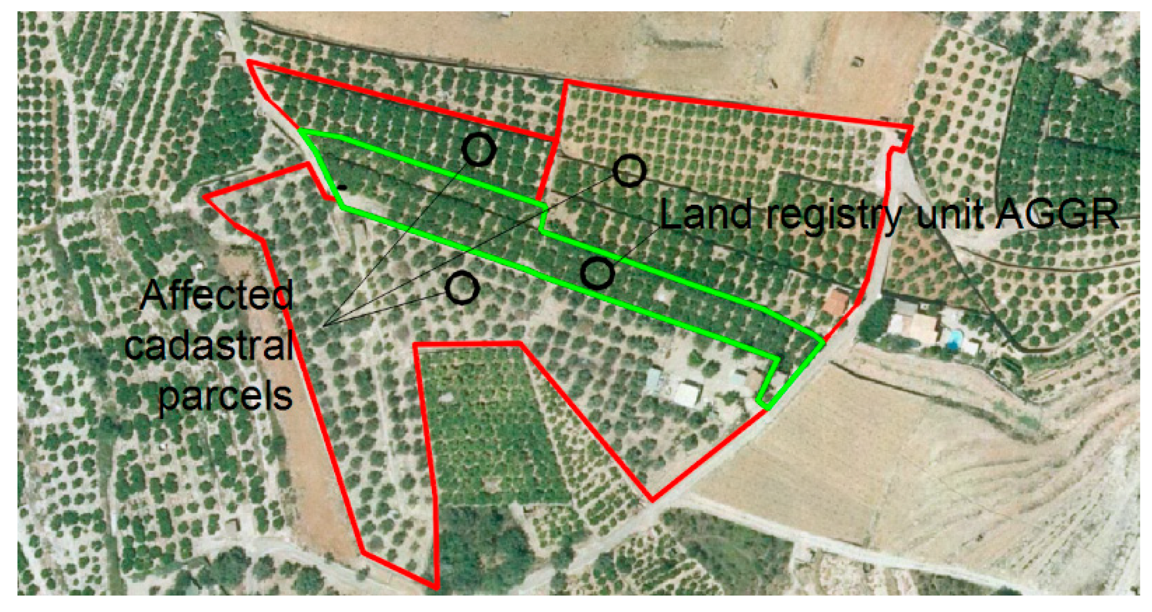
  • The technician modifies all the neighbouring cadastral parcels, so they adapt to the AGGR. Only the boundaries of the cadastral parcel shared with the AGGR must be modified. Figure 2 provides an example. The green lines denote the AGGR, which replace old boundaries. The red lines represent the remaining perimeter of the neighbouring boundaries that have not been amended. The outcome is the new cadastre configuration in the area where the action is taken.
  • The technician creates a GML (Geographic Markup Language) file of each new cadastral parcel shape: the delimited one and the affected ones. The GML file must follow the specification of the Cadastral Parcel theme in Annexe I of INSPIRE, referred to henceforth as GML.
  • The technician accesses the cadastre’s website in the validation system and uploads the GML files. The technician’s identity has to be accredited by, for instance, a digital certificate. The validation system issues a report that either confirms or denies whether it is possible to make the necessary changes in parcels to reflect the new reality. Figure 3 shows part of the report of the example offered in the Figure 2.
Figure 3. Positive cadastral report. Source: own elaboration.
Land 11 01107 g003
  • The cadastre’s validation system also generates a code, known as the Secure Validation Code (referred to henceforth as the SVC), which enables anyone who knows this code to retrieve the report. The usefulness of the SVC is that notaries and land registrars can access the validation report, the geometry of the AGGR in the GML format, and the list of coordinates of survey points.
  • Interested users only need to know the SVC to go to a notary or land registry to conduct business.
  • The notary or land registrar makes the necessary legal verifications that (s)he considers suitable by producing a newly written document that must be registered in the land registry.
  • Both notary and land registrar must provide the cadastre with any resulting legal information so that the cadastre can actually change geometries.
  • The parcel’s new geometry is registered in the land registry as an AGGR.
  • If the validation report and legal information in the land registry are correct, the cadastre must change the geometries during a maximum 5-day period, as set out in Law 13/2015.
  • The cadastre notifies the land registry that the cadastral parcel has been coordinated with the land registry unit. The land registry unit is now considered coordinated.
  • Registry-related attestation is applied not only to register legal information, but also to the parcel’s perimeter, whose coordinates can be obtained from the cadastre at no charge.
  • The descriptive and graphical cadastral certifications of coordinated cadastral parcels show that the parcel status is coordinated.
It is important to point out that the verifications made by the cadastre’s validation system are both geometric and automatic. A positive report only means that geometries are correct, and that no gaps or overlaps occur. A positive report does not ensure that the proposed changes will be made. For the proposed geometric changes to be made, legal information is also necessary, e.g., property deeds, demarcation minutes, etc., which must be provided by a notary or land registrar and must be previously qualified by the latter.
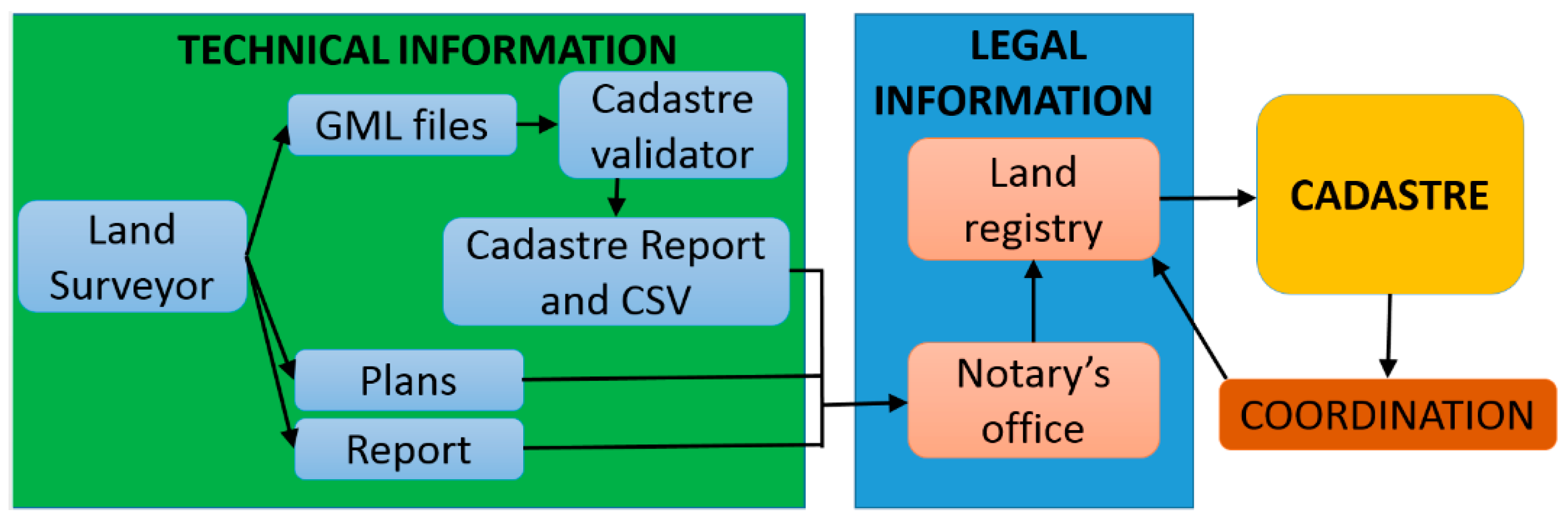
This new system separates technical work from legal or juridical work in such a way that each working role is played by the corresponding expert (Figure 4). The technician makes the land survey, maps, the land survey report, and the GML files, and obtains the cadastre’s validation report. Notaries and land registrars know from the SVC that the geometrical changes in the cadastre can be made if the legal information is correct. Legal information is the responsibility of notaries and land registrars, while technicians are responsible for technical information.
This new cadastral cartography updating system implies considerable participation in the cadastre by the private sector. Such participation lies in the fifth declaration of the Cadastre 2014 document: “Cadastre 2014 will be highly privatised. Public and private sectors are working closely together” [11].
The cadastre has made huge efforts to conduct cadastral surveys, make inventories and digitalise the whole Spanish territory. The final cadastral cartography covers all the Spanish territory, but its characteristics are extremely heterogeneous. The purpose of this cartography was tax-oriented. Moreover, the territory is constantly changing. Now, the intention is that cadastral cartography updating is not the result of the new investments made by the cadastre in a new cartography. The intention is that such updating takes place by parties interested in sending new territory configurations, regardless of them being public (e.g., town/city councils) or private (owners, buyers, leaseholders, etc.). During this updating period, the role played by the cadastre’s validation system is key because it:
  • Guarantees technicians that their delimitation is geometrically correct
  • Guarantees notaries and land registrars that, if they attach correct legal information, updating shall be completed in 5 days after submitting legal information. Therefore, real-state trade does not stop.
  • Reduces the editing workload performed in cadastre offices and transmits it to free-profession technicians. The free-profession technicians draw the new parcel configurations in each updating.
With the cadastre’s validation system, the Spanish cadastre outsources field surveying, like most cadastral systems in developed countries, following the approach of using interchange text files in the GML format [53].
The cadastral validation system was launched on 16 December 2015. The software for the cadastre–land registry and cadastre–notary communication is still being developed. This software will allow legal information to flow from notaries and land registries to the cadastre in an automated fashion, and vice versa. Seven years later, on 11 May 2022, there were 660,228 coordinated properties, but all of them coincided with the current cadastral maps; hence, no cadastral map updates where required. With respect to the AGGR, the communication channel is not still working. Therefore, all the land registry units with an AGGR remain still non-coordinated.
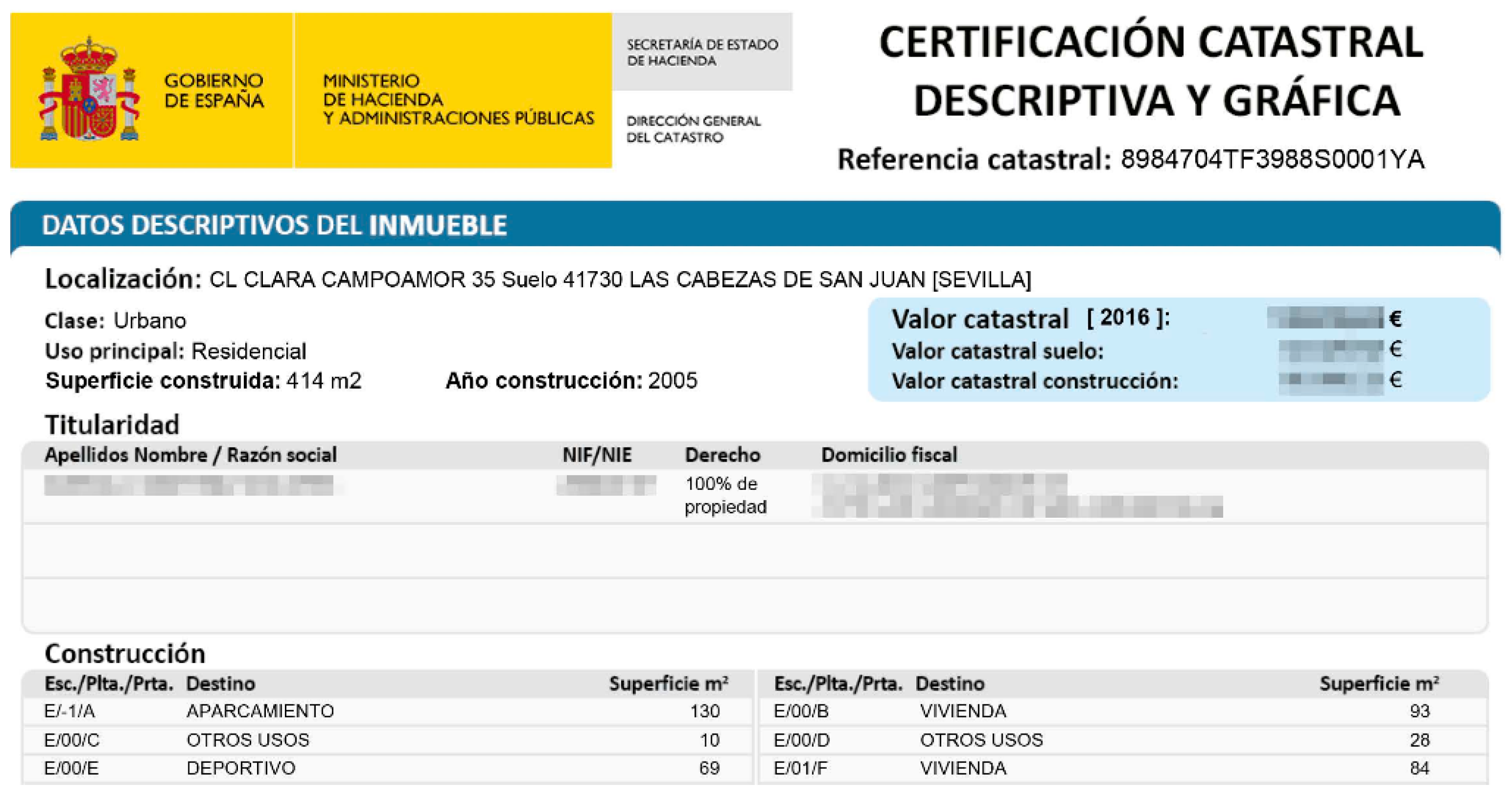
A system has been created for the cadastre to perform its new task: to act as a geographical basis to identify land registry units, and to locate them on the terrain in the official Spanish coordinates system so that, when a property is coordinated, there is no ambiguity about the location and limits of the land registry unit as its coordinates are assumed certain and, therefore, exact. Nonetheless, no exact coordinates exist as they tend to have an error margin, as explained in the methodology employed to obtain these coordinates. With the validation system, the cadastre saves some metadata about each update of every parcel: the author responsible for the geometry and the date. Additionally, any boundary metadata appear in the descriptive graphical cadastral certifications (DGCCs) obtained from the cadastre. The DGCCs (Figure 5) are the documents employed in most businesses in which a property is involved, according to Spanish law.
Mismanagement of geographical data causes disputes between neighbours and authorities in Spain and hinders many property transactions. When the same line has several versions, only geographical metadata can find which is the best line. For example, in Spain, it is possible to find different boundaries for the same municipality on different maps, with differences bigger than the map tolerance [54].
We are proposing that the Spanish cadastre allows the introduction of the qualitative component and quantitative component of the NEM Data Quality class for the land registry unit geometry, at the moment of generating the report validation in the cadastre website, in AGGR cases. For example:
Qualitative component:
Statement: Boundary determination of the land registry unit X, corresponding with the cadastral parcel Y, according to what is written in the deeds. The cadastral map does not coincide with reality and needs to be updated. No neighbours were present during the survey. To take the measurements, a GPS was used. The standard deviation of the coordinates obtained is, according to the public RTK corrections service, better or equal to 5 cm. The final area of the land registry unit is Z m2, 8% bigger than the area that appears in the deeds, A m2.
Process step:
Step 1: Northern and eastern boundary measurement. They are well-established on the ground by a wall that belongs to the land registry unit, so they have been measured by the outside side. The worst standard deviation in the points of this boundary, according to the RTK corrections service, is 0.05 m. The maximum error (99% probability) in these boundary points is 0.125 m.
Step 2: Southeast boundary measurement. It is an embankment, between 2 to 4 m wide. According to local custom, 2/3 of the embankment belongs to the upper land registry unit. Therefore, 2/3 of this embankment has been given to the land registry unit object of this survey, because it is over the neighbouring property. To find this boundary, the upper and lower embankment limits have been measured. A computer aid design program has been used to draw the embankment limits and to interpolate the 2/3 parts of width. A boundary point has been interpolated each 2 m. The limits of the embankment were not clear. We estimate a strip of land uncertainty of 0.5 m in the embankment limits. Due to that, we estimate that the maximum error in this boundary is 0.5 m.
Step 3: West boundary reposition. This boundary is lost and has been repositioned. The coordinates of this boundary have been obtained by georeferencing an old cadastral map, made in 1942, at a scale of 1/5000. This map is available in the Historical Map Archive of Alicante. The georeferencing control point’s standard deviation was 1 m. This boundary’s maximum error (99% probability) is 2.5 m.
Source: For the boundary determination of this land registry unit, the following sources have been used:
Old cadastral map, made in 1942, scale 1/5000, available in the Historical Map Archive of Alicante.
Current cadastral maps and current aerial national orthophotography.
Land registry unit deeds.
Quantitative component:
Name of measure: Absolute External Positional Accuracy.
Measure description: Coordinate maximum error, in the coordinate system of the boundary coordinates, of the land registry unit.
Result:
Value unit: m.
Value: 2.5.
Because it is necessary to be identified to make an AGGR validation on the cadastre website, the author and date are automatically recorded. In the above metadata, the absolute external positional accuracy was set to 2.5 m because it is the worst boundary accuracy achieved in all the boundaries, although the GPS used in the survey gives much better accuracy. This is due to the lack of precise information about one of the boundaries of the land registry unit, which is a common situation in Spain in the countryside. With this information, in the AGGR validation report, and an XML format for normal users, it is possible to understand how each neighbour’s independent boundary has been obtained, and this can offer the following advantages:
  • More transparency in the conditions of the coordinates of each boundary can help neighbours reach agreements in a notary or land registry office.
  • This metadata will help land surveyors delimit adjacent land registry units.
  • This metadata will help solve possible future disputes between neighbours when another solution for one boundary appears. In these cases, it will be possible to compare the techniques used and see if both solutions are compatible or not. No exact solution exists, and despite two boundaries being different, they can be not contradictory. Metadata will allow determining which is the best solution.
These geographical metadata can only be associated with the cadastral parcel polygon geometry, because the Spanish cadastre only maintains one layer of polygons. A line string layer, with a different boundary for each neighbour will be more appropriate. This will allow setting an NEM data quality instance for each line string, avoiding the textual description of each neighbour’s boundary, in the cadastral parcel metadata. This is the case for the GeoDelProp geoportal.

5. Methodology

A prototype of software was created with the goals of facilitating the data inputting and querying and making a demonstration to land registrars, showing them some real delimitation cases. The prototype was called TopoDelProp (a plugin for QGIS 2). We met with two land registrars who acceded to test the system. They proposed some pending land registry unit delimitations.
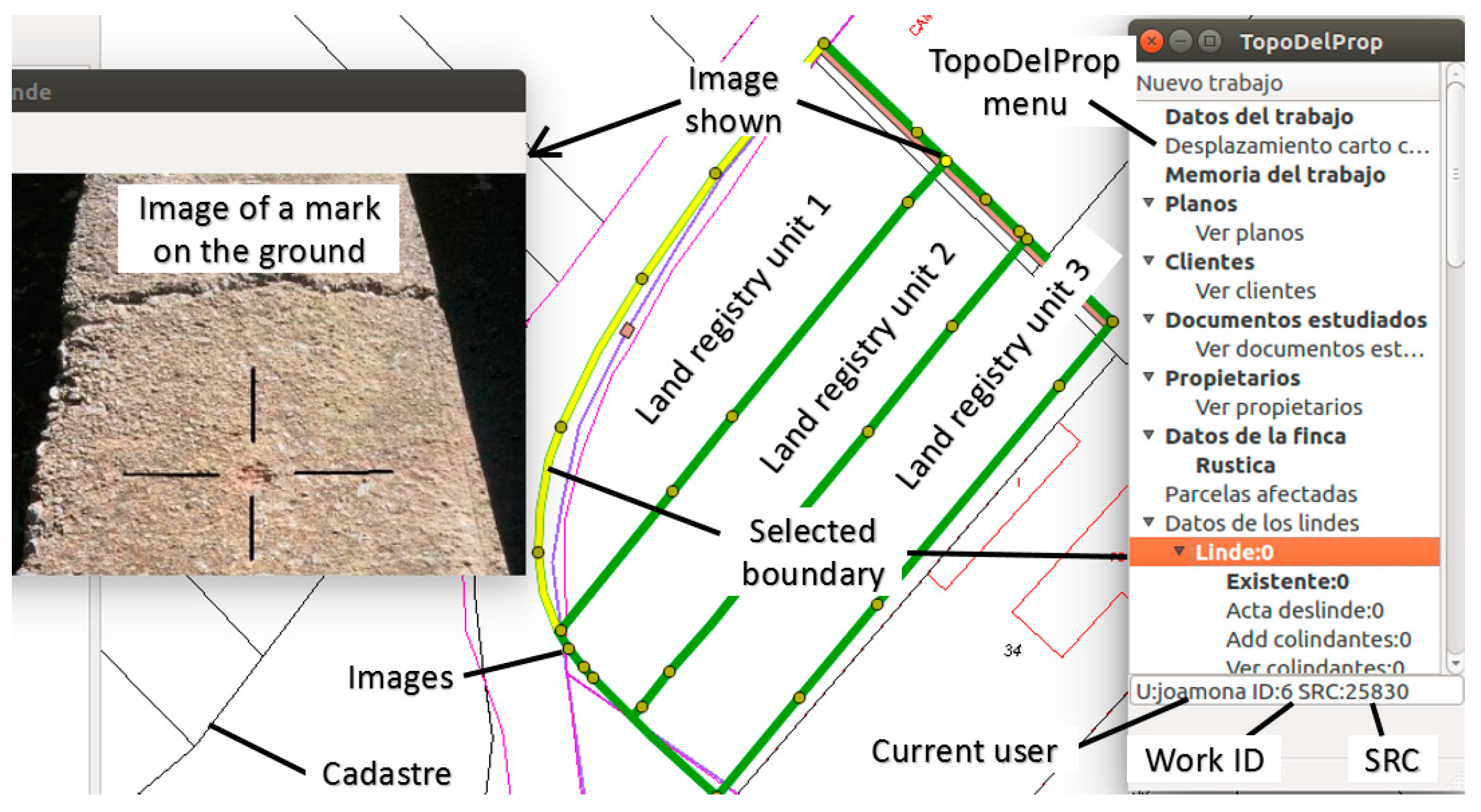
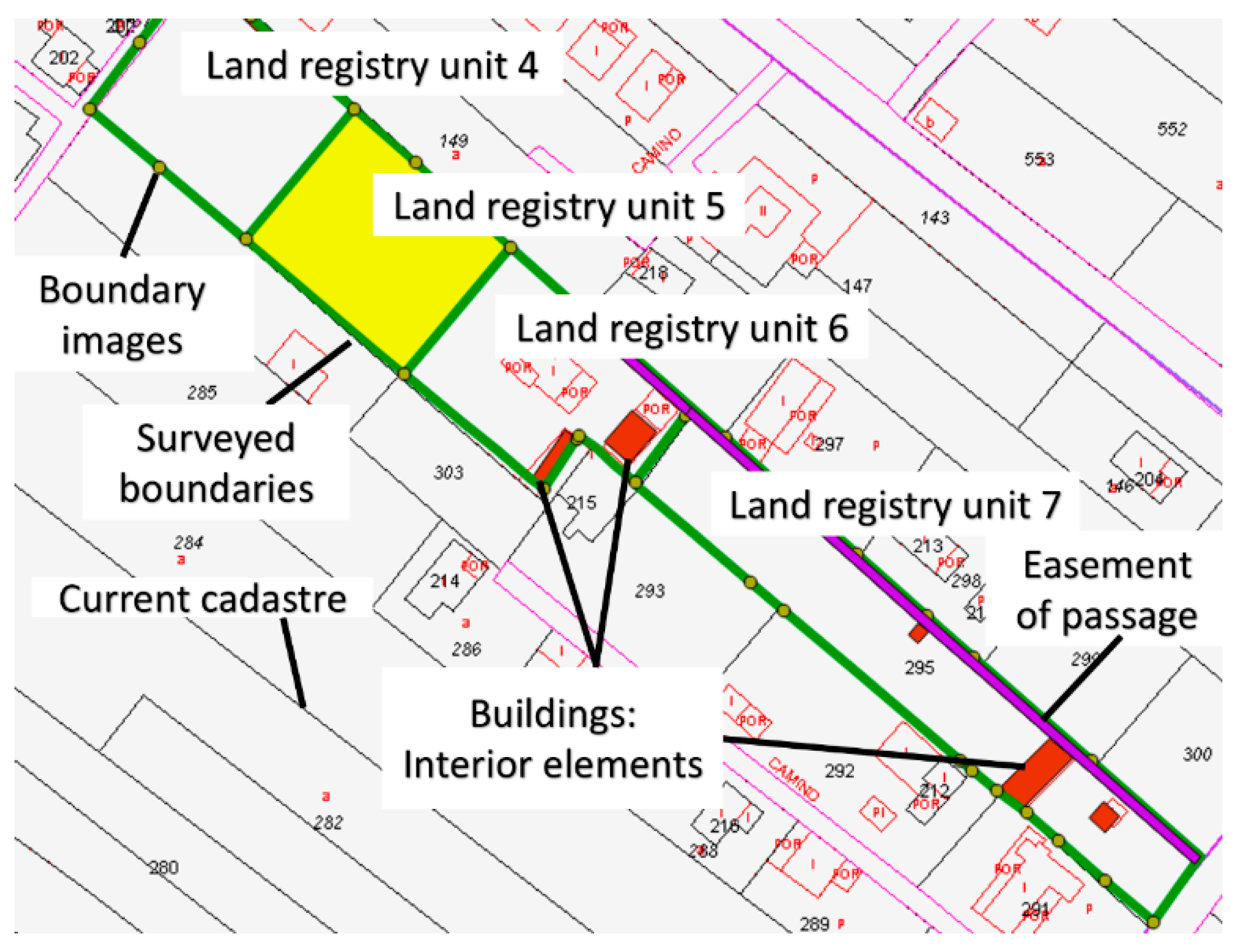
Eight land registry unit delimitations were made, and the data were inputted into the system. In the first case, three land registry units within the same cadastral parcel were delimited (Figure 6). In this case, one land registry unit had been divided into three, but the land registrar did not know what shape each new land registry unit took. The land registrar notified owners and neighbours, but only owners attended, who indicated the limits of each land registry unit on the ground. The three land registry units were well-delimited by marks. One of these marks is presented in Figure 6, which involves a small incision made on the wall of an irrigation channel.
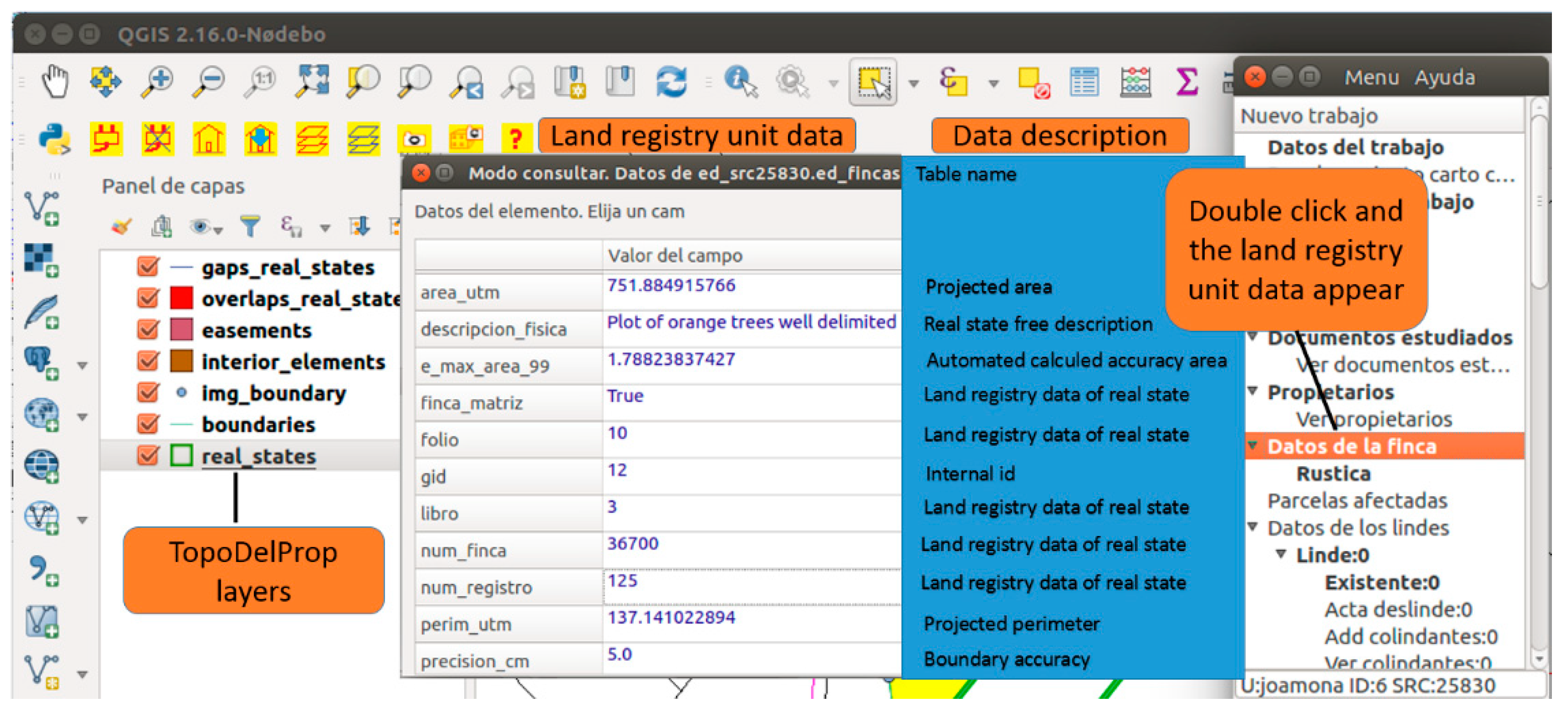
Different delimitation work was conducted for each parcel, which saves all the geometries, documents and metadata of parcels. All these data explain how delimitation was performed, as well as the accuracies achieved, in each geographical element that composes the work. The data of a given work can be consulted by loading these in the TopoDelProp menu, and then double-clicking on the element to be consulted in the TopoDelProp menu (Figure 7).
At the land registry, four more land registry units with similar problems were delimited (Figure 8). As in the former case, only the owners were present while measurements were taken.
In all cases, the delimitation data were inputted into the TopoDelProp system, specifically in land registries, so land registrars could acquire technical data and assess the system’s usefulness. The results were hardly promising due to two problems. Firstly, a technological barrier was detected. Using a geographical information system such as QGIS proved difficult for non-GIS experts and, despite plug-in TopoDelProp, information was not easily accessible. Secondly, one of the land registrars agreed to meet with the neighbours affected by the delimitations. However, none came to the land registry, not even the owners who had agreed to and attended the delimitation of their parcels. This means that none of the delimitations were registered in the land registry.
It is possible to see the non-protected data of the land registry unit delimitations made in these tests in the geoportal GeoDelProp.

6. Prototype to Manage Data and Metadata of Land Registry Unit Delimitations. TopoDelProp

This section describes the data and metadata managed by TopoDelProp. We should bear in mind that the database is designed from a land surveyor’s point of view and to support notaries and land registrars. Data are divided into non-spatial and spatial data.
Non-spatial data:
User: each work delimitation is associated with the user who creates it in the system. Personal data are saved.
Data of the surveying: the descriptive general data of the delimitation work are saved.
Surveying report: this is a PDF document with non-regulated content used to explain the surveying work, for instance, describing the problem to be solved, equipment used, documents used to solve the work, decisions made, accuracy achieved, process steps, etc.
Map: intermediate maps created to solve the delimitation, and the map solution. The number of maps is limitless.
Documents used: the documents studied to solve the land registry unit delimitation, such as property deeds, registrations, cadastral maps, orthophotographs, urban plannings, etc.
Customers: each customer’s personal data and his/her scanned national ID card. The customers are the people who pay for the delimitation work.
Owners: each owner’s personal data and his/her scanned national ID card.
Neighbours: each neighbour’s personal data and his/her scanned national ID card.
Spatial data:
Land registry units: surface elements. This defines the geometry of the land registry unit and its descriptive data. Each land registry unit, which can be composed of several polygons, is associated with a single delimitation work.
Boundaries: Independent linear elements for each neighbour. Boundaries are the most important elements of the database and require the most metadata, as boundaries are the element that limit the property/parcel. Therefore, they define up to what point owners’ rights reach. Boundaries have general metadata, which are saved along with their geometry, and, depending on the boundary type, they may have some specific data. Boundaries are classified into four types:
Boundaries that are well-distinguished on the ground and can be measured. In this case, the existing physical element on the ground can be described.
Boundaries that are not well-distinguished on the ground and have to be repositioned. In this case, the method followed to obtain the coordinates is described, normally performed by using different cartographies.
Boundaries that are not well-distinguished on the ground because they form part of a design plan, e.g., urban planning, or parcels of replotting.
Boundaries that have been determined without making a visit to the field, and have been digitalised on an orthophotograph, for example.
For all boundary types, whether an agreement has been reached or not with neighbours, the boundary’s final accuracy and demarcation minutes, if they exist, are saved. Unlike LADM, or the Cadastral Parcel theme of INSPIRE, where boundaries are associated with one land registry unit or two, in this system, boundaries are associated with only one land registry unit (Figure 9): the land registry unit which has been delimited by the land surveyor. This was designed like that because free-profession land surveyors are usually hired for the delimitation of only one land registry unit; therefore, they are not going to introduce data into the system for the neighbouring land registry units. The other land surveyor in charge of delimiting a neighbouring land registry unit must check the already-recorded common boundary but must not enter it again in the database. The database rejects overlapped boundaries and boundaries not over the perimeter of the delimited land registry unit.
  • Images: they are sporadic elements that indicate the position of an image taken when measuring a boundary. Their usefulness lies in helping us to understand where the boundary is delimited (Figure 9). Data from that point are saved as one image per point. Images are associated with a boundary.
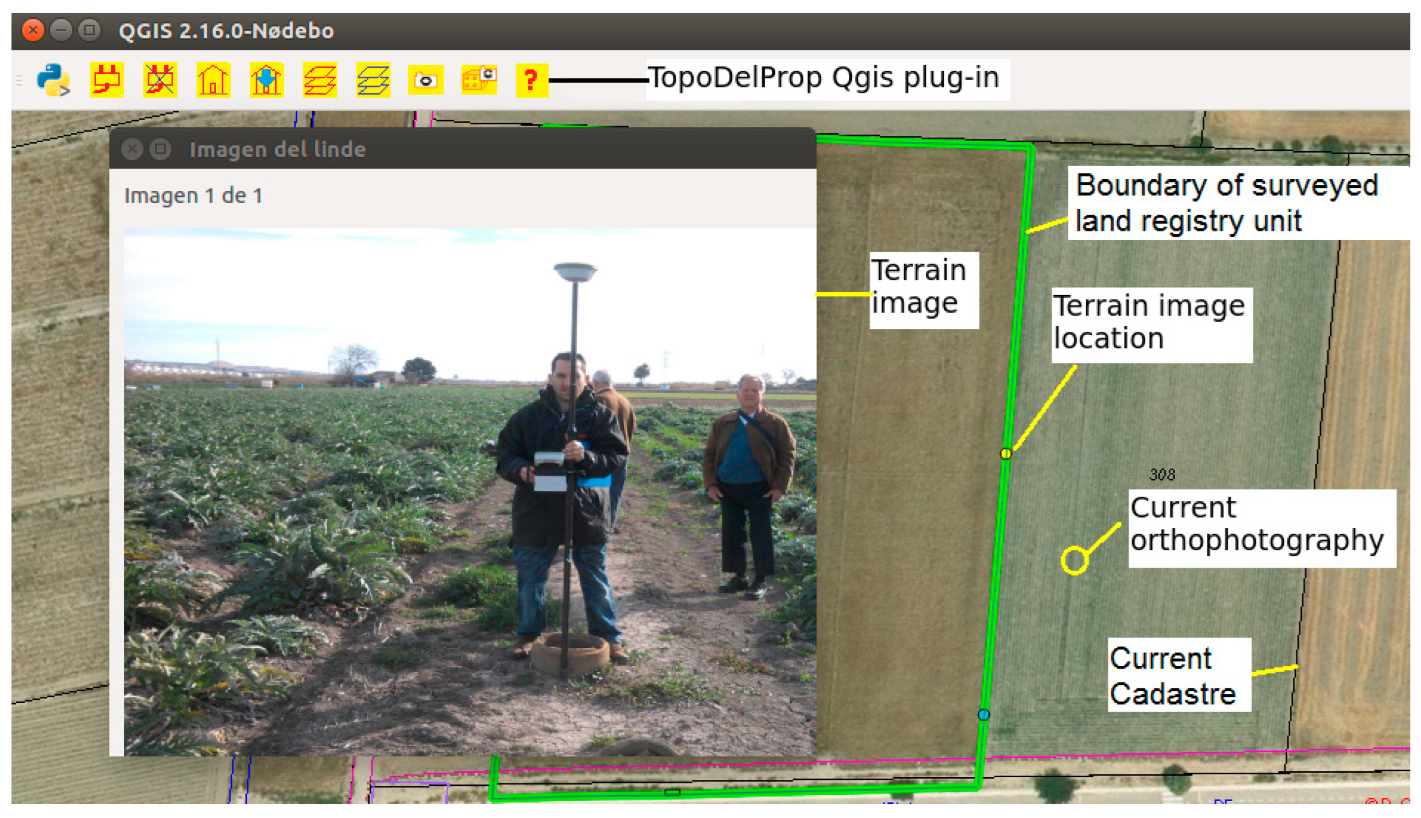
Figure 9. TopoDelProp plug-in showing an image and its location on the ground. Source: own elaboration.
Land 11 01107 g009
  • Interior elements: they are surface elements that fall within a land registry unit: buildings, swimming pools, etc. An indefinite number of images can be associated with each interior element which, in turn, is associated with a land registry unit.
  • Easements: if a land registry unit has easements and can be delimited by a closed polygon, it can be measured, drawn and added to the database. Each easement is associated with a land registry unit.
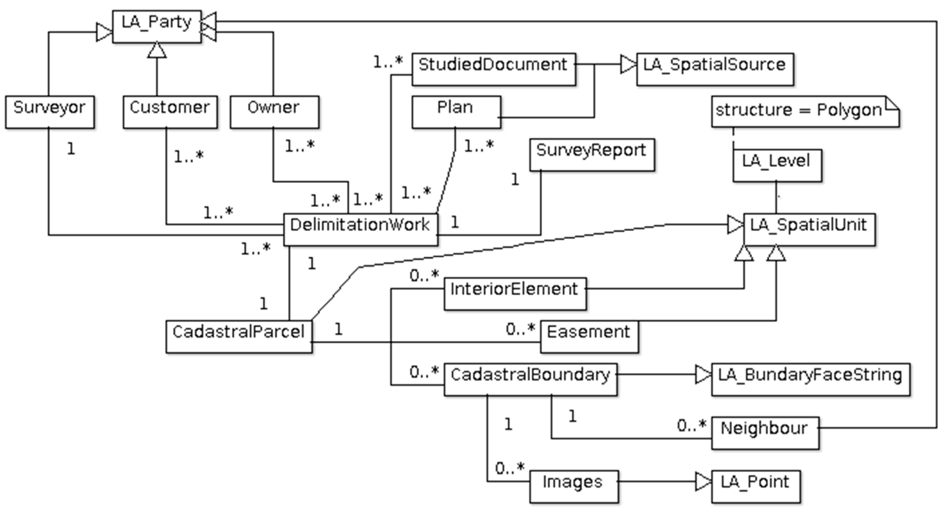
With the data that the database manages, a correspondence can be established with some LADM classes (Figure 10):
  • Data of the people who intervene in the delimitation work: land surveyors, owners, customers and neighbours, which correspond to instances of the LA_Party class.
  • The delimitation work report and maps that correspond to the LA_SpatialSource class.
  • The documents used for conducting the delimitation work correspond to LA_SpatialSource classe.
  • The parcel delimited in the delimitation work corresponds to the LA_SpatialUnit class.
  • Boundaries correspond to the LA_BoundaryFaceString class.
  • Images of boundaries are sporadic elements associated with a boundary and correspond to the LA_Point class.
  • Interior elements and easements correspond to the LA_SpatialUnit class.
All the introduced data are checked by the TopoDelprop database in real-time. The database checks the attribute data and the topology of new geometries. The difference with other systems is that the topological restrictions of geometries are checked against all the database geometries: overlays, inclusions, etc. Geometries can come in any format that QGIS can read. Therefore, users enter data directly into the database in a temporal space, and an administrator accepts, or rejects, the delimitation work. Most systems use XML format to exchange information, and users generate XML files, e.g., ePlan. ePlan is currently operational in Australia, New Zealand and Singapore. ePlans contain cadastral plans and survey information, which includes survey measurements, dimensions of parcels, interests in land (e.g., easements and restrictions), land parcel descriptions, administrative information (e.g., locality), owners’ corporation schedules, survey marks, traverses, radiations, connections to the title, annotations, plan approval status and stakeholders’ signatures. ePlans are submitted to a cadastral digital plan lodgement portal [55]. ePlan is a LandXML subset [56]. Anyone can check an XML file using common applications, as well as the XML schema definition file, but checks do not include any topological restriction. Another interchange format is INTERLIS, the Swiss standard language that enables land information system communications [57]. The INTERLIS language allows checks to be made of topological restrictions in interchange information files, but only between the geometries included in the file data.
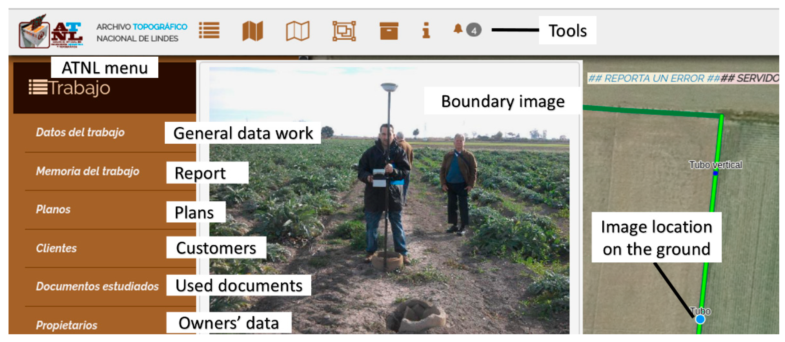
On 11 May 2015, the Spanish Engineering in Geomatics and Land Surveying Association (COIGT) Board passed the project to create the ATNL http://www.coit-topografia.es/VerNoticias.aspx?Cod=1620 (accessed on 13 July 2022) (Spanish National Topographical Archive of Boundaries). To undertake this project, TopoDelProp was employed as the basis. For this purpose, a collaboration agreement was signed with the Universitat Politècnica de València (Polytechnic University of Valencia, Valencia, Spain). The ATNL does away with using the TopoDelProp plug-in but employs the same database and applies the same philosophy. Data are inputted and can be consulted on a geoportal. Figure 11 shows a delimitation work by means of the ATNL.
The development of the ATNL was stopped due to:
  • Lack of resources and the complexity of the developing software. For example, topology geometry checks require projected coordinate systems to be able to calculate overlaps and intersections between geometries. In Spain, four zones of UTM projection are used. This usually means duplicating the geometry tables four time to store each geometry in the corresponding zone. This also implies choosing, for each municipality in the UTM zone borders, in which zone to store the land registry unit geometries. To avoid this problem and to have continuous cartography in large areas, the geometry coordinates should be stored in ellipsoidal coordinates. Topological checks on the ellipsoid surface are usually performed by projecting the geometries locally to obtain flat coordinates, or by assuming some approximations, therefore finding important deviations in calculations, that usually users are unaware of [58].
  • Introducing the information in TopoDelProp system takes one or two hours for a trained user, producing an extra cost. This is because the land surveyor must manually create the geometries as topologically correct, not only internally with the delimitation geometries, but with the existing geometries in the database. This means that it is necessary to download the existing geometries in the database and to adapt the new geometries to the existing geometries. This process is not easy and needs voluntary training and time.

7. Discussion

Since Law 13/2015 came into force in Spain, cadastral cartography is the basis for knowing where land registry units are located. The Spanish cadastre has made huge efforts to adapt to perform this important task by creating a system that validates geometries to speed up cadastral updating and save certain metadata about the author and the new cartography’s characteristics.
The Spanish land registry is also investing strongly in technology to save the geometries of land registry units, publish them on the Internet, and implement mechanisms to communicate with the cadastre.
Thanks to the Spanish Law 13/2015, which some authors have described as being revolutionary, when a land registry unit is coordinated with the cadastre, the land registry unit’s coordinates are considered certain, thanks to extending registry-based legitimacy to the georeferencing of the land registry unit. The land registry unit coordinates are, in principle, assumed certain, unless otherwise demonstrated. This has led some authors to state that a parcel’s value will not be the same if it is coordinated than if it is not.
Coordinating parcels between the cadastre and the land registry is a huge step for security in the land registry units’ trade, but we think it is still necessary for Spain to add the management of geographical metadata about boundaries. As the land registry puzzle is completed, new land registry units, whose graphical representations people wish to register, will have less space and will come into conflict with already registered ones. This will be the time when the geographical metadata of boundaries will come into play. As no exact solution exists for the boundary coordinates, geographical metadata will determine which delimitation is better. Computerised geographical metadata that are easy to access and understand will be fundamental during this process.
Demarcation of properties is much more than a survey of a plot. Usually, it is necessary to gather and generate a large amount of information that justifies the final land registry unit boundary determination solution. TopoDelProp and GeoDelProp are free software prototypes, created to demonstrate that the geographical metadata of land registry units provide security and can be managed. However, the performed tests did not attract much interest, especially among owners and neighbours. We conclude that this is caused by a lack of information of the owners. We realised that ordinary owners perceived that the cadastral cartography and the information in the deeds of their properties is perfect, simply because they come from official databases. This leads to a lack of interest in making preventive investments in future conflicts. However, experience shows that when a conflict arises, in many cases, it is already too late, and both repositioning boundaries and neighbours reaching an agreement are much harder to achieve.
Even though the TopoDelProp plug-in makes access to the information easy, a technological barrier was detected in land registries to retrieve the land registry unit’s delimitation metadata. It can be concluded that for non-GIS experts, it is better to use a geoportal with specific tools to obtain the information they need, avoiding software installations and non-required tools that can be overwhelming.
ATNL was TopoDelProp’s adaptation to the COIGT’s requirements. The objective was to offer an added service that increases security to the delimitation of properties. This service is based on facilitating access and understanding of geographical data and their metadata in land registry unit’s delimitations. Nevertheless, a lack of resources, the complexity of the developing software, and training demands for users led to the project’s abandonment.
The Spanish Law 13/2015 attaches more importance to the boundary geometry of properties. We think that geographic metadata about boundary property must be considered just as important as the geographical data themselves, because they indicate how reliable the property boundary is. The reliability of a land registry unit boundary can be described with the data quality class of the NEM standard. We recommend that the Spanish cadastre extends its computer systems to manage the data quality gathered by technicians in AGGR cases and offer this metadata as a public service.
Future research could investigate if coordinated land registry units reach a higher value than the non-coordinated ones, as some authors stated. If the answer is affirmative, such research could encourage more owners to start the coordination process voluntarily.

Author Contributions

Conceptualization, C.F.-R. and G.M.-N.; methodology, C.F.-R., G.M.-N. and J.M.-L.; software, J.M.V.T., G.M.-N. and J.M.-L.; Land surveys G.M.-N. and J.M.V.T. All authors have read and agreed to the published version of the manuscript.

Funding

This work was partially supported by the research projects: ‘The land registry as the basic tool for organising spatial information; INSPIRE Directive, spatial data and metadata’, DER2011-23321/JURI; and ‘Current situation and future developments of land registry information: towards a new land administration model’, DER2014-52262-P. Both projects were financed by the Spanish government.

Institutional Review Board Statement

Not applicable.

Informed Consent Statement

Not applicable.

Data Availability Statement

Not applicable.

Conflicts of Interest

The authors declare no conflict of interest.

References

  1. Bennett, R.; Tambuwala, N.; Rajabifard, A.; Wallace, J.; Williamson, I. On recognizing land administration as critical, public good infrastructure. Land Use Policy 2013, 30, 84–93. [Google Scholar] [CrossRef]
  2. Griffith-Charles, C.; Sutherland, M. Analysing the costs and benefits of 3D cadastres with reference to Trinidad and Tobago. Comput. Environ. Urban Syst. 2013, 40, 24–33. [Google Scholar] [CrossRef]
  3. Williamson, I.; Enemark, S.; Wallace, J.; Rajabifard, A. Land Administration for Sustainable Development; ESRI Press Academic: Redlands, CA, USA, 2010; ISBN 978-1-58948-041-4. [Google Scholar]
  4. Navratil, G.; Andrew, U. Frank’s impact on research in land administration. Int. J. Geogr. Inf. Sci. 2018, 32, 2501–2513. [Google Scholar] [CrossRef] [Green Version]
  5. De Soto, H. El Misterio del Capital; Planeta: Barcelona, Spain, 2000; ISBN 978-612-319-437-6. [Google Scholar]
  6. Berné Valero, J.L.; Femenia-Ribera, C.; Benítez Aguado, E. Catastro en España; Universitat Politècnica de València: Valencia, Spain, 2008; ISBN 978-84-8363-242-0. [Google Scholar]
  7. Bydłosz, J. The application of the Land Administration Domain Model in building a country profile for the Polish cadastre. Land Use Policy 2015, 49, 598–605. [Google Scholar] [CrossRef]
  8. Castanyer, J. Marco administrativo: Sistemas de administración de la tierra en Europa (MOLA). Panorama de los catastros europeos. CT Catastro 1997, 31, 79–92. [Google Scholar]
  9. Van der Molen, P. The dynamic aspect of land administration: An often-forgotten component in system design. Comput. Environ. Urban Syst. 2002, 26, 361–381. [Google Scholar] [CrossRef]
  10. Pullar, D.; Donaldson, S. Accuracy issues for spatial update of digital cadastral maps. ISPRS Int. J. Geo-Inf. 2022, 11, 221. [Google Scholar] [CrossRef]
  11. Kaufmann, J.; Steudler, D. Cadastre 2014: A vision for a future cadastral systems. In Proceedings of the FIG XXI International Congress, Brighton, UK, 19–25 July 1998; p. 44. [Google Scholar]
  12. Döner, F.; Thompson, R.; Stoter, J.; Lemmen, C.; Ploeger, H.; van Oosterom, P.; Zlatanova, S. 4D cadastres: First analysis of legal, organizational, and technical impact—With a case study on utility networks. Land Use Policy 2010, 27, 1068–1081. [Google Scholar] [CrossRef]
  13. Döner, F.; Thompson, R.; Stoter, J.; Lemmen, C.; Ploeger, H.; van Oosterom, P.; Zlatanova, S. Solutions for 4D cadastre—With a case study on utility networks. Int. J. Geogr. Inf. Sci. 2011, 25, 1173–1189. [Google Scholar] [CrossRef]
  14. Lemmen, C.; Van Oosterom, P.; Bennett, R. The Land Administration Domain Model. Land Use Policy 2015, 49, 535–545. [Google Scholar] [CrossRef] [Green Version]
  15. Kalantari, M.; Dinsmore, K.; Urban-Karr, J.; Rajabifard, A. A roadmap to adopt the Land Administration Domain Model in cadastral information systems. Land Use Policy 2015, 49, 552–564. [Google Scholar] [CrossRef]
  16. Gogolou, C.; Dimopoulou, E. Land administration standardization for the integration of cultural heritage in land use policies. Land Use Policy 2015, 49, 617–625. [Google Scholar] [CrossRef]
  17. Góźdź, K.J.; van Oosterom, P.J.M. Developing the information infrastructure based on LADM—The case of Poland. Surv. Rev. 2016, 48, 168–180. [Google Scholar] [CrossRef] [Green Version]
  18. Mader, M.; Matijević, H.; Roić, M. Analysis of possibilities for linking land registers and other official registers in the Republic of Croatia based on LADM. Land Use Policy 2015, 49, 606–616. [Google Scholar] [CrossRef] [Green Version]
  19. Paixao, S.; Hespanha, J.P.; Ghawana, T.; Carneiro, A.F.T.; Zevenbergen, J.; Frederico, L.N. Modeling indigenous tribes’ land rights with ISO 19152 LADM: A case from Brazil. Land Use Policy 2015, 49, 587–597. [Google Scholar] [CrossRef]
  20. Zulkifli, N.A.; Abdul Rahman, A.; van Oosterom, P.; Tan, L.C.; Jamil, H.; Teng, C.H.; Looi, K.S.; Chan, K.L. The importance of Malaysian Land Administration Domain Model country profile in land policy. Land Use Policy 2015, 49, 649–659. [Google Scholar] [CrossRef]
  21. Adeniyi, P.O.; Akingbade, A.; Akande, A. Solutions for Open Land Administration (SOLA) software—customizing open source software to support the systematic land titling registration pilot project in Ondo State, Nigeria. In Proceedings of the 2015 World Bank Conference on Land and Poverty, Washington, DC, USA, 23–27 March 2015; p. 35. [Google Scholar]
  22. Velasco Martín-Vares, A. La norma ISO TC 2011 19 152, sobre el Modelo Catastral. Land Administration Domain Model (LADM). CT Catastro 2016, 87, 7–33. [Google Scholar]
  23. Sánchez-Maganto, A.; Rodríguez Pascual, A.F.; Abad Power, P.; López Romero, E. El Núcleo Español de Metadatos, perfil mínimo recomendado de metadatos para España. In Proceedings of the II Jornadas Técnicas de la IDE de España (JIDEE2005), Madrid, Spain, 24 November 2005; pp. 1–11. [Google Scholar]
  24. ICSM Cadastre 2034 Strategy, Powering Land and Property. Available online: https://www.icsm.gov.au/sites/default/files/Cadastre2034_0.pdf (accessed on 6 July 2022).
  25. Renteria-Agualimpia, W.; Lopez-Pellicer, F.J.; Lacasta, J.; Zarazaga-Soria, F.J.; Muro-Medrano, P.R. Improving the geospatial consistency of digital libraries metadata. J. Inf. Sci. 2016, 42, 507–523. [Google Scholar] [CrossRef] [Green Version]
  26. Di, L.; Shao, Y.; Kang, L. Implementation of Geospatial Data Provenance in a Web Service Workflow Environment With ISO 19115 and ISO 19115-2 Lineage Model. IEEE Trans. Geosci. Remote Sens. 2013, 51, 5082–5089. [Google Scholar] [CrossRef]
  27. Enemark, S.; Mclaren, R.; Lemmen, C. Fit-for-Purpose Land Administration-providing secure land rights at scale. Land 2021, 10, 972. [Google Scholar] [CrossRef]
  28. McLaren, R. How Big Is Global Insecurity of Tenure? Available online: https://www.gim-international.com/content/article/how-big-is-global-insecurity-of-tenure (accessed on 13 July 2022).
  29. Todorovski, D.; Salazar, R.; Jacome, G.; Mclaren, R.; Lemmen, C. Assessment of land administration in Ecuador based on the Fit-for-Purpose approach. Land 2021, 10, 862. [Google Scholar] [CrossRef]
  30. Balas, M.; Carrilho, J.; Lemmen, C. The Fit for Purpose Land Administration approach-connecting people, processes and technology in Mozambique. Land 2021, 8, 818. [Google Scholar] [CrossRef]
  31. Shankar Panday, U.; Chhatkuli, R.; Joshi, J.R.; Deuja, J.; Antonio, D.; Enemark, S. Securing land rights for all through Fit-for-Purpose Land Administration approach: The case of Nepal. Land 2021, 10, 744. [Google Scholar] [CrossRef]
  32. Chigbu, U.E.; Bendzko, T.; Mabakeng, M.R.; Kuusaana, E.D.; Tutu, D.O. Fit-for-purpose land administration from theory to practice: Three demonstrative case studies of local land administration initiatives in Africa. Land 2021, 10, 476. [Google Scholar] [CrossRef]
  33. Fandos Pons, P. El Sistema de información geográfica registral español. In Proceedings of the III Conferencia y Asamblea de la Red Interamericana de Catastro y Registro de la Propiedad, Montevideo, Uruguay, 14–17 November 2017. [Google Scholar]
  34. Alonso Peña, C. Productos y servicios sobre estándares internacionales (INSPIRE): Aceptación y uso en el tráfico inmobiliario. In Proceedings of the III Conferencia y Asamblea de la Red Interamericana de Catastro y Registro de la Propiedad, Montevideo, Uruguay, 14–17 November 2017. [Google Scholar]
  35. Velasco Martín-Vares, A. Smart successful cadastral new tools for real estate registration: “all in 16 digits”. In Proceedings of the Joint PCC & EULIS Conference. The Current Technological Trends in Land Registration, Vittoriosa, Malta, 5 May 2017. [Google Scholar]
  36. Velasco Martín-Vares, A.; Alonso Peña, C.; Virgos, L.; Serrano, F. Inspire services of the Spanish Directorate General for Cadastre and its use to resolve an old problem of coordination between Spanish Cadastre and Land Registry. In Proceedings of the INSPIRE Conference 2016, Barcelona, Spain, 11–15 September 2016. [Google Scholar]
  37. Velasco Martín-Vares, A. The “back office” of the Spanish cadastre that makes possible the interaction with partners. In Proceedings of the Conference of PCC, EuroGeographics-Cadastre and Land Registry KEN and EULIS, Bratislava, Slovakia, 17–18 November 2016. [Google Scholar]
  38. Spanish General Directorate for Cadastre. EuroGeographics Increasing legal certainty and transparency in Spain. In EuroGeographics Annual Review; Spanish General Directorate for Cadastre: Madrid, Spain, 2015; p. 44. [Google Scholar]
  39. Femenia-Ribera, C. Caso de estudio en España. Ley 13/2015 sobre coordinación Catastro-Registro. In Proceedings of the FIG Commisision 7 and 9 Annual Conference and Meeting, Cartagena de Indias, Colombia, 4–8 December 2017. [Google Scholar]
  40. Velasco Martín-Vares, A.; Alonso Peña, C. Smart cadastral tools for real estate registration. GIM Int. 2017, 31, 33–35. [Google Scholar]
  41. Alonso Peña, C.; Blanco Urzaiz, J. La función del Registro de la Propiedad y la función del Catastro. In Proceedings of the Agencia Española de Cooperación Internacional para el Desarrollo (AECID), Cartagena de Indias, Colombia, 15–18 November 2016. [Google Scholar]
  42. Blanco-Urzáiz, J. La coordinación entre el Registro de la Propiedad y el Catastro Inmobiliario tras la Ley 13/2015 en España. In Proceedings of the II Reunión y Conferencia de la Red Interamericanca de Catastro y Registro de la Propiedad, Ciudad de Panamá, Panamá, 27 September 2016. [Google Scholar]
  43. Blanco-Urzáiz, J. The coordination between the Property Registry and the Cadastre in the aftermath of Law 13/2015 in Spain. In Proceedings of the UNECE WPLA Workshop: State and Market: Cadastres and Property Rights Registries, Madrid, Spain, 24–25 November 2016. [Google Scholar]
  44. Fandos Pons, P.; Alonso Peña, C. The Spanish cadastre and property rights: A smart model of coordinated interaction. In Proceedings of the Common Vision Conference 2016, Amsterdam, The Netherlands, 5–7 June 2016; pp. 1–18. [Google Scholar]
  45. Velasco Martín-Vares, A. Spanish Cadastre: Collaborative maintenance and dissemination. In Proceedings of the Meeting of the Permanent Committee on Cadastre in the European Union, Rome, Italy, 20–21 November 2014. [Google Scholar]
  46. Velasco Martín-Vares, A. Política y resultados del catastro abierto español. In Proceedings of the II Reunión y Conferencia de la Red Interamericana de Catastro y Registro de la Propiedad, Ciudad de Panamá, Panamá, 27–30 September 2016. [Google Scholar]
  47. Jiménez-Clar, A. Perfiles de la coordinación de la información territorial gráfica, en la Ley 13/2015, de 24 de junio, de reforma de la Ley Hipotecaria y de la Ley de Catastro Inmobiliario. CT Catastro 2016, 64, 27–50. [Google Scholar]
  48. Gómez Gálligo, J. Grandes expectativas derivadas de la Ley 13/2015, de 24 de junio en relación a la coordinación del Registro de la Propiedad y del Catastro. CT Catastro 2015, 84, 13–26. [Google Scholar]
  49. Trystuła, A.; Dudzí Nska, M.; Ryszard´zróbek, R.R. Evaluation of the Completeness of Spatial Data Infrastructure in the Context of Cadastral Data Sharing. Land 2020, 9, 272. [Google Scholar] [CrossRef]
  50. Berné Valero, J.L.; Femenia-Ribera, C. Catastro de Rústica; Universitat Politècnica de València: Valencia, Spain, 2000; ISBN 84-7721-941-9. [Google Scholar]
  51. Femenia-Ribera, C.; Mora-Navarro, G.; Pérez, L.J.S. Evaluating the use of old cadastral maps. Land Use Policy 2022, 114, 105984. [Google Scholar] [CrossRef]
  52. Thompson, R.J. A model for the creation and progressive improvement of a digitalcadastral data base. Land Use Policy 2015, 49, 565–576. [Google Scholar] [CrossRef]
  53. Vranić, S.; Matijević, H.; Roić, M. Modelling outsourceable transactions on polygon-based cadastral parcels. Int. J. Geogr. Inf. Sci. 2015, 29, 454–474. [Google Scholar] [CrossRef]
  54. Femenia-Ribera, C.; Mora-Navarro, G.; Benítez-Aguado, E.; Garrido-Villén, N. Estudio y análisis de la representación de la línea límite de término municipal según diversas cartografías en la albufera de Valencia. Scr. Nova. Rev. Electrónica Geogr. Y Cienc. Soc. 2013, 17, 448. [Google Scholar]
  55. Olfat, H.; Shojaei, D.; Briffa, M.; Maley, S.; Rajabifard, A. Strategic actions for increasing the submission of digital cadastral data by the surveying industry based on lessons learned from Victoria, Australia. ISPRS Int. J. Geo-Inf. 2018, 7, 47. [Google Scholar] [CrossRef] [Green Version]
  56. Shojaei, D.; Olfat, H.; Rajabifard, A.; Darvill, A.; Briffa, M. Assessment of the Australian digital cadastre protocol (ePlan) in terms of supporting 3D building subdivisions. Land Use Policy 2016, 56, 112–124. [Google Scholar] [CrossRef]
  57. Kalogianni, E.; Dimopoulou, E.; Quak, W.; Germann, M.; Jenni, L.; van Oosterom, P. INTERLIS language for modelling legal 3D spaces and physical 3D objects by including formalized implementable constraints and meaningful code lists. ISPRS Int. J. Geo-Inf. 2017, 6, 319. [Google Scholar] [CrossRef] [Green Version]
  58. Martínez-Llario, J.; Baselga, S.; Coll, E. Accurate algorithms for spatial operations on the spheroid in a spatial database management system. Appl. Sci. 2021, 11, 5129. [Google Scholar] [CrossRef]
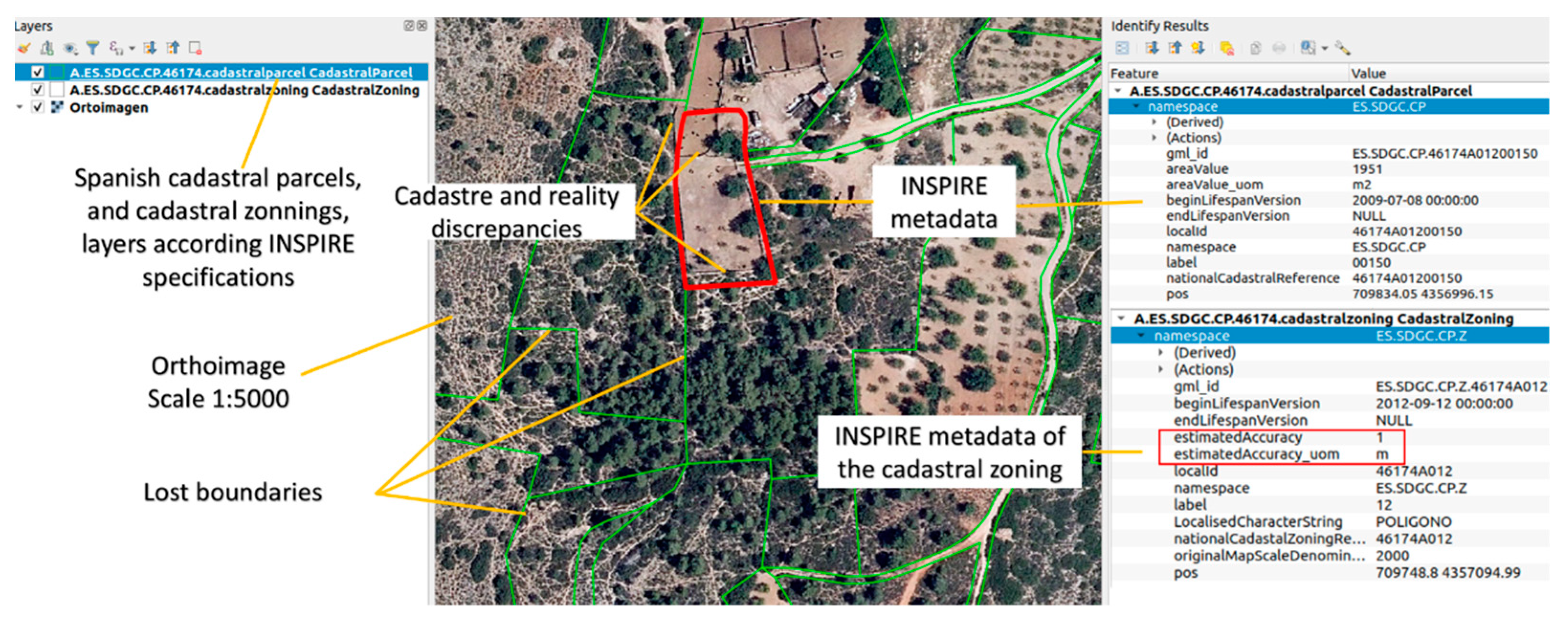
Figure 1. Example of Spanish INSPIRE Cadastral Parcel and Cadastral Zoning layers (themes) information. In the figure, one can see ground lost boundaries and cadastre and reality discrepancies. Source: own elaboration.
Land 11 01107 g001
Figure 2. Bounded land registry unit and affected cadastral parcels. Source: own elaboration.
Land 11 01107 g002
Figure 4. Roles in land administration in Spain. Source: own elaboration.
Land 11 01107 g004
Figure 5. Part of a descriptive geographical certificate of a cadastral parcel. Source: Spanish cadastre.
Land 11 01107 g005
Figure 6. Three land registry units within the same cadastral parcel. Source: own elaboration.
Land 11 01107 g006
Figure 7. Data inquiry with TopoDelProp plug-in showing the parcel data. Source: own elaboration.
Land 11 01107 g007
Figure 8. Land registry units delimited and recorded in the TopoDelProp system. Source: own elaboration.
Land 11 01107 g008
Figure 10. UML class diagram of TopoDelProp. Source: own elaboration.
Land 11 01107 g010
Figure 11. Land registry unit work delimitation watched across the ATNL geoportal. Source: ATNL screen shot.
Land 11 01107 g011
Publisher’s Note: MDPI stays neutral with regard to jurisdictional claims in published maps and institutional affiliations.