1. Introduction
Public housing in Israel is defined as urban planning of entire neighborhoods and cities on state lands, supervised by the Ministry of Housing. This is the commonly accepted definition today. However, since the state’s establishment in 1948 and through to the 1980s, the definition was broader, since public housing also included responsibility for the actual construction [
1] (p. 9).
As such, Israeli public housing was imbued by multiple contents, added to the strictly planning ones. First, as in the postwar European countries, it was used primarily to provide housing solutions for marginalized populations [
2] and to create a beneficent urban space, seen then—in both Europe and Israel, which relied on the European precedents—as green, relatively thinly populated, and meticulously planned and zoned. This was a reaction to the noisy, dirty, disease-ridden city that developed in the Industrial Revolution [
3]. The direct precedents for Israeli public housing were the new towns planned in the UK during the Second World War and built afterwards [
4,
5]. The indirect precedents were British planner Ebenezer Howard’s (1960 [1898]) Garden City [
6] and American Planner Clarence Perry’s (1929) Neighborhood Unit [
7].
The State of Israel, however, did not settle for this social aspect and tied additional values to public housing that articulated its stated ideology. Since Israel considered itself a socialist country, the public housing projects met its duty to provide shelter for the entire population, and were therefore minimal in size [
8]. This was due both to shortage of resources and to a strong opposition to the bourgeois way of life, as evident in luxury housing. Moreover, the housing projects were made up of identical buildings and housing units over large portions of the entire neighborhood. Here, too, coupled with the need for saving, a value was embedded: equality.
Since Israel absorbed Jewish immigrants from all over the world in the aftermath of statehood—tripling its entire population within a single decade—social cohesion was deemed another essential value. The idea was that the green areas between the buildings would serve as the “community’s home”, where the children could play and their parents could get to know each other until a cohesive society would form [
9]. The apartments themselves, of modernist planning and appearance, were supposed to “educate” the immigrants to a life of progress, particularly those with “the primitive mentality of many of those arriving from backward countries” [
10]. In a similar vein, the architect of the state company, appropriately named Shikun (“Housing”), believed that the immigrant must be taught “how one should live in an apartment” [
11], meaning the modernist apartment.
The green area between the buildings also represented another value, nationalist and unique to a new state such as Israel, most of whose potential (Jewish) citizens were still living in the diaspora: the attachment to the land. To establish “normal” nationality, grounded in an unmediated relation to the land, the planners saw great significance in sparsely constructed neighborhoods full of open areas. Some of them, even those within cities, were planned as agricultural neighborhoods, with a private urban agricultural garden attached to each family unit for growing vegetables for its own consumption. “In addition to the private urban agricultural gardens’ economic importance, they also hold immense public educational importance, since they educate both the adults and – in particular – the younger generation in the love of nature and live attachment to the land…”, wrote a local housing leader [
12]. Clearly, the Zionist ideology sought to transform the diasporic Jew, who was not an agricultural laborer, into a physical, rooted Jew, attached to his land. Public housing was designed to promote this ideology even when it did not include home farms, but only extensive, shared green areas between the houses [
13].
With the years, the status of public housing transformed. Having dominated the construction in Israel in the 1950s and 60s, the model was privatized gradually in the 1970s and 80s. Apart from a short period in the early 1990s when Israel once again dealt with a huge immigration wave, this time from the former Soviet Union, public housing was increasingly substituted by private construction. The socialist and nationalist ideology behind the planning of the housing fabrics also changed with time. After two generations of citizens who were born in Israel and who were immersed in its culture and landscape, there was no longer an urgent need to create a cohesive society or ensure the inhabitants’ rootedness. The economy completed the transition from a socialist to a capitalist one. Following these broader changes, the planning of the housing fabrics became denser and more urban, defining street spaces using adjacent construction and urban blocks, dotted with park and square spaces [
14]. Another European model used by the Israeli planners was the return to the traditional city, meaning the preindustrial European city with its streets, boulevards, squares, and urban blocks [
15,
16].
Following the privatization and the transition to a free market more broadly, which has affected the Israeli economy in additional areas, a specific definition of
urban renewal was adopted in the 2000s, often with direct reference to the public housing fabrics from the 1950s and 60s, which became increasingly decrepit and lost all ideological justification. Note that urban renewal is commonly used as a general name for spatial actions designed to revive a deteriorated urban fabric. These activities can start by improving public space in the neighborhood and thereby attract capital, business enterprises, and new tenants to the neighborhood [
17]. They can include improving the neighborhood’s access to the urban center or centers outside the city by convenient transportation [
18]. They can also include regulations that encourage population from the “creative class” (artists and professionals, as defined by Richard Florida) to re-inhabit the neighborhood, using its low real estate values and the charm of non-bourgeois fabrics [
19,
20]. All these types of action are relevant, but in Israel of the last decade, the words “urban renewal” are code for reinforcing, broadening, and heightening old condominiums, or destroying and rebuilding a new one, or several new ones, instead of the old construction, mostly of public housing from the 1950s and 60s.
The new buildings contain a larger number of housing units to make the construction denser and thus better use the limited land resources. Indeed, the Ministry of Construction and Housing (2012) website states that “The main objective of the urban renewal project is to add construction in constructed areas. This addition is important given the shortage of land resources in Israel. It also contributes to reviving the constructed fabric, introducing new land uses, preventing the aging of the population, making better use of underused public infrastructures and institutes, and preserving open areas” [
21].
In 2022, there are several major pathways to promoting urban renewal in Israel. Some of them are initiated by the state or municipality (top down), while others are initiated by the tenants, albeit with state incentives (bottom-up), including:
Condensation of construction: Adding construction in existing projects without evacuating the tenants, by adding, for example, rooms, balconies, and floors.
Evacuation-construction: Demolishing and rebuilding a given project (one or several buildings) with considerable condensing. This process requires evicting all tenants and providing them with temporary housing at the contractor’s expense. It is promoted by local authorities in their municipal areas or by the tenants, supported by an urban renewal administration. Thus, municipal authority helps tenants assess the project’s economic viability and directs them to the appropriate agencies—either public authorities or private contractors incentivized by a reduced tax burden.
National Outline Plan 38 (commonly referred to TAMA 38), designed to reinforce buildings constructed before 1980 against earthquakes, by providing them with an economic incentive in the form of extensive construction permits; it is promoted for each building separately by private entrepreneurs or by the tenants [
22]. It commonly includes closing the open ground floor, adding another new section to the building, and usually also construction on top [
23]. Since the plan is an Israeli countrywide plan, it is also used to issue construction permits, without preliminary recourse to a local or detailed outline plan [
24]. This pathway is designed to improve the building’s resilience to earthquakes by reinforcing and strengthening it (TAMA 38/1 and 38/3, respectively), or by destroying and rebuilding it (TAMA 38/2). Most of the plan’s provisions deal with extending construction rights, mainly for additional housing units on the existing roof, which represent the contractor’s incentive for financing the construction reinforcement.
What all pathways share is reliance on private capital. In the spirit of the overall privatization of the Israeli economy, free-market entrepreneurs are currently responsible for new construction, rather than a state body such as the Ministry of Housing. The capital is also strictly private, rather than public or public and private, as required in the urban renewal actions detailed above. Consequently, new construction is carried out on one condition only: forecast profit for the contractor, by selling the new apartments in the free market. Thus, the higher the land value, as in high-demand areas, building less new apartments can still garner profit, and vice versa, meaning that in peripheral areas, more apartments must be built to ensure profit, increasing each project’s overall density [
25,
26].
Throughout this article we will examine how ideological shifts, such as capitalism or private funds, are reflected economically, permeate government and local conduct, impose its own interests on the built environment, and generate facts on the ground [
27]. However, the conduct of urban renewal and its consequences also reveals these facts, even when it is not iconic architectural works that blatantly tell the story of capitalism [
28,
29]. The process of capitalist globalization is growing into a complex system that dominates the built environment and promotes the privatization process, which results in privatization of parts of the public spaces, such as the urban renewal process of an innocent urban residential neighborhood, similar to the case study of this research.
Architecture and planning that have expressed a socialist historical heritage give way to architecture and planning that express bourgeois values [
30], without preserving previous values, quantitative and qualitative [
31], and without a quality new planning environment. Gainza [
32] also suggests that the representation of the neighborhood space influences the cultural characteristics of neighborhood transformation. This paper examines how the "resuscitation" neighborhood changes not only its character, but also its occupants and pushes some of the previous occupants out [
32,
33]. At the end of the article, it is shown that without a deliberate public hand and public participation process, privatized planning will fail.
Based on this review, the present study addresses the following questions: What are the values of public housing fabrics undergoing urban renewal? And is the current construction mechanism that relies mainly on the private market capable of providing improved spatial qualities for the built environment? Following these questions, the main goal of this research is to examine the qualitative and quantitative values of the neighborhood after undergoing "urban renewal" in terms of the purity of private money.
2. Methodology
To understand the outcome of the urban values and quality of a renewed urban site, the renewed urban environment was analyzed from three main aspects:
Evaluated the quality of housing and the built environment using several quantitative urban measures. For example, the changing spatial quality was traced by evaluating walkability in the neighborhood, open vistas, the variety of housing units, the openness of space between buildings, and additional parameters. The evaluation process consists of site observations and plans analysis, similar to the analysis developed in [
34].
Compared the qualitative values of the old and new constructions: equality, community, attachment to the land, individualism, and capitalism.
Examined the site’s long-term resilience before and after the urban renewal in the light of changes in the complex space.
For the analysis, three main tools were used: First, site observations that enable assessing the current situation of the built environment; second, planning drawing analysis, including site plans, housing units plans and sections, aerial photo analysis, etc., for comparing and assessing previous situation (based on the municipality archive), existing and planned situations; and third, interviews with professional stakeholders in the municipal decision-making process and current residents, for understanding the potentials and limitations of the site’s urban renewal.
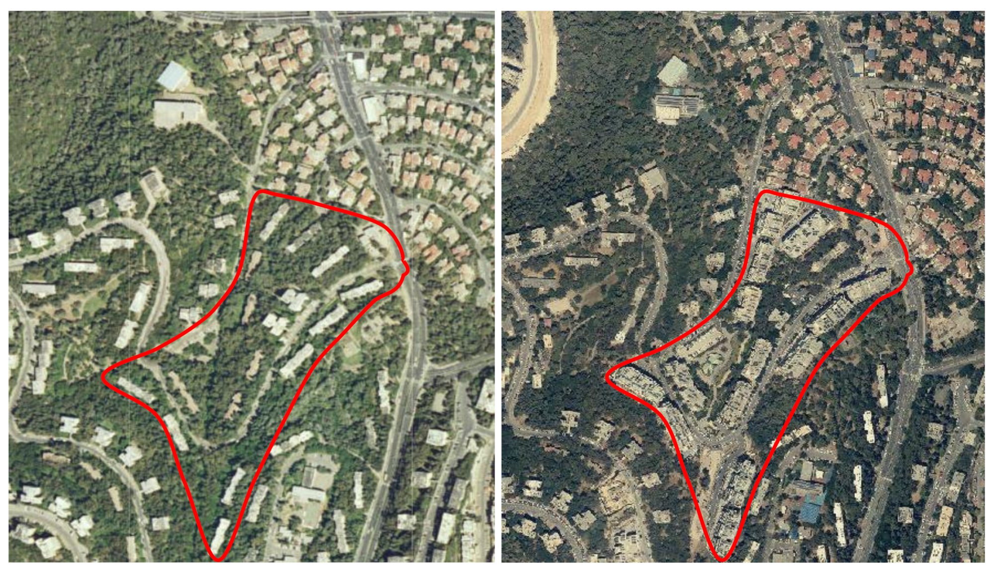
The case study of a public housing project that had undergone massive urban renewal was selected: the Haviva Reich Street Complex at the Ramot Remez Neighborhood in Haifa, Israel.
In this study, the effect of urban renewal by studying the quality of the renewing public space was examined. This is because a high-quality public space attracts tenants, promotes human contact, and eventually contributes to the emergence of a caring community, which preserves the neighborhood and prevents its deterioration over the long run.
2.1. The Case Study
2.1.1. The Ramot Remez Public Housing Neighborhood before Urban Renewal
The case study is located in the Ramot Remez neighborhood in southern Haifa. The neighborhood was planned as a public housing project in 1957 and approved in 1959. The planning and construction company was Shikun Ovdim (literally, “Workers’ Housing”)—a public company working for the state Housing Division in the Ministry of Labor [
35]—suggesting that the project was designed for longtime Israelis, including young couples.
1 The sloped land on which the project was constructed was state land south of Haifa. The site is eccentric to the city’s CBD, which lies north, on the slopes of Mt. Carmel.
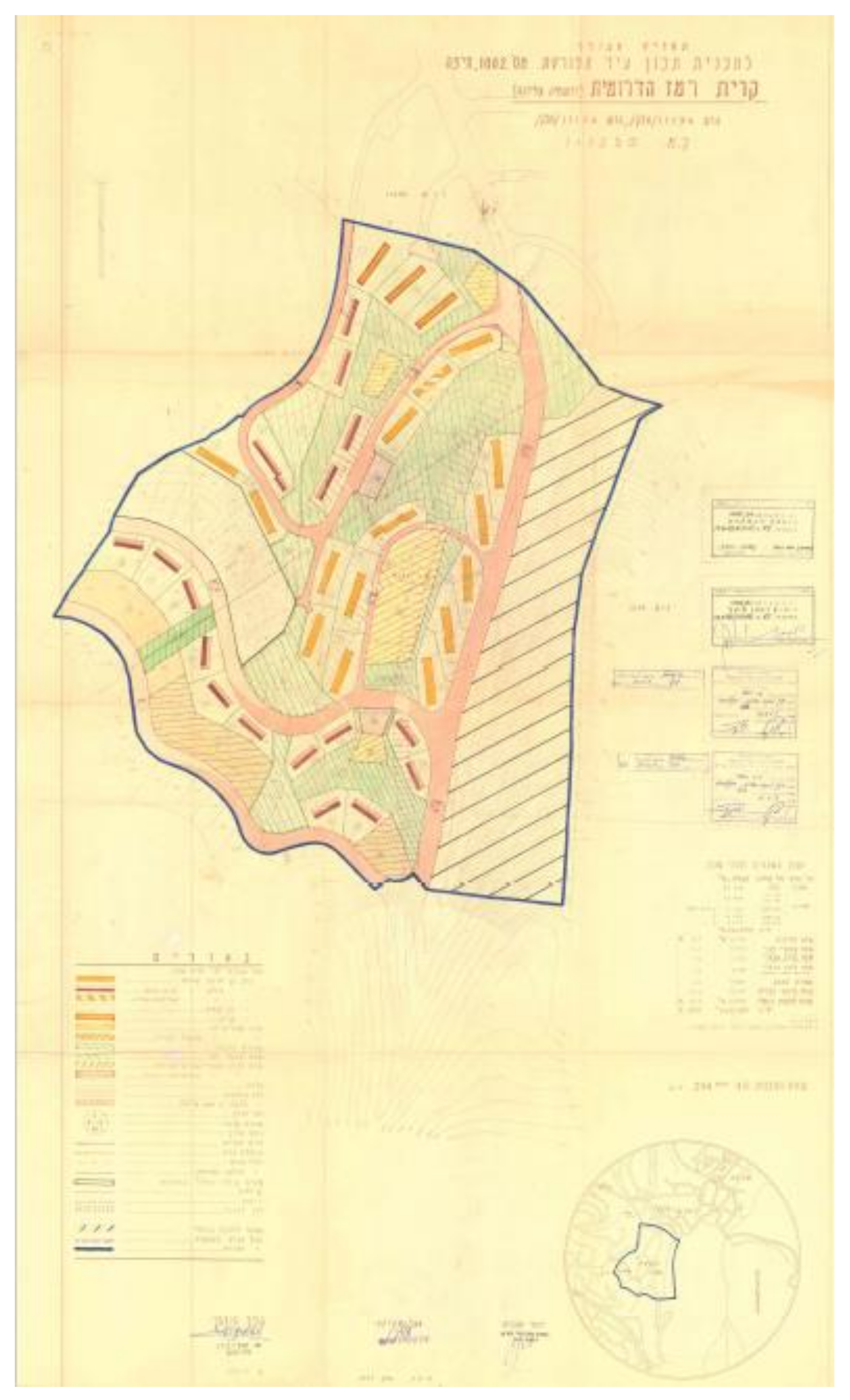
The neighborhood was built next to a previous public housing project, from 1951, and in parallel to the development of a university campus for engineers and architects— the Technion (Israel Institute of Technology), about 1 kilometer away, as the crow flies, and 2 kilometers (as the crow flies) from the University of Haifa developed in the 1970s. Covering an area of some 66 acres, the neighborhood was planned on a mountainous terrain, with its narrow streets and buildings following the contour lines. At its center lay a nature reserve and multiple open public areas. Thirty-two elongated residential buildings were planned at low density, with intervals of relatively 20 meters and more between the buildings, each with three staircases. The 17 three-story buildings had slate roofs and included a total of 240 housing units (
Figure 1, colored pink and burgundy), except for one that had a flat roof and an open ground story (
Figure 1, colored orange and white). The remaining 15 buildings had four stories and a flat roof, and included 364 housing units (
Figure 1, colored brown). A total of 604 housing units where thus planned for the neighborhood. Various plots were designated mainly for non-commercial public buildings (
Figure 1, colored striped yellow), and a few for commercial buildings (
Figure 1, colored striped pink).
The project regulations stated that “The building of any auxiliary buildings will not be allowed... in the open areas between the residential buildings for the purpose of organized housing, but only in the buildings’ foundations”, and that “The tenants will be required to plant decorative gardens…” [
36]. They also stipulated that “rainwaters will be drained by permeation into the ground or by above-ground flows, or by a specially approved channeling system" [
36] (p.5). We quote those sentences in order to emphasize the additional importance of the wide area between the building for the quality of housing in the project and the importance of the open areas in the neighborhood for the natural ecosystem.
Qualitative urban examination of the characteristics of the open public space in the neighborhood suggests that most of the inner streets were one way, relying on the main street called International Street (thus embodying the social values underpinning the project). The neighborhood was located at a walking distance from a significant commercial center, but the center was located on a relatively sharp slope, too sharp for safe walking. Conversely, the walk to the campus followed the contour lines and is relatively comfortable. Public transportation passed through the neighborhood, leading to various urban centers in Haifa.
The Haviva Reich Street Complex—destined for urban renewal years later—was a one-way street with a single entrance and two exits, surrounded by natural forest. This main street was served continually by three bus lines that stop several times an hour, throughout the day. Housing density was low, about five housing units per dunam (~1/4 acre), and the gaps between the buildings (20 meters or more) enabled to preserve wide green spaces. Some of the open public area was not treated, and part of it was included in the nature reserve. All parking spots were public, along the streets, without any private parking on the building plots. Walkability within the neighborhood was comfortable, leading to the main streets connected to the neighborhood center, the schools, and universities, so that the neighborhood offered access to important centers around it.
The values encapsulated in the Israeli public housing projects, as described in the Introduction, are present in this one as well. The identical two-bedroom apartments expressed modesty and equality. The plan and its modernist appeal expressed the aspiration to create an advanced and Western society. The multiple open spaces between the buildings were designed to establish rootedness (
Figure 2), as these green areas were used by children and parents to meet, as there was not enough room in the small apartments. These meetings, the planners hoped, would create vibrant communities.
2.1.2. The Case Study: The Haviva Reich Site after Urban Renewal
The two-bedroom apartments, the fact that the houses lacked elevators or private parking, and the general rise in the Israeli standard of living made many abandon the neighborhood. Part of the remaining original population is old. Other apartments are rented out by the owners to youngsters, mostly students in the Technion or the Haifa University. From the perspectives of the municipality and Ministry of Construction and Housing, this is a rundown neighborhood. It is therefore no surprise that in 2003, part of the neighborhood, the Haviva Reich Street Site, was found appropriate for urban renewal [
37] (
Figure 3).
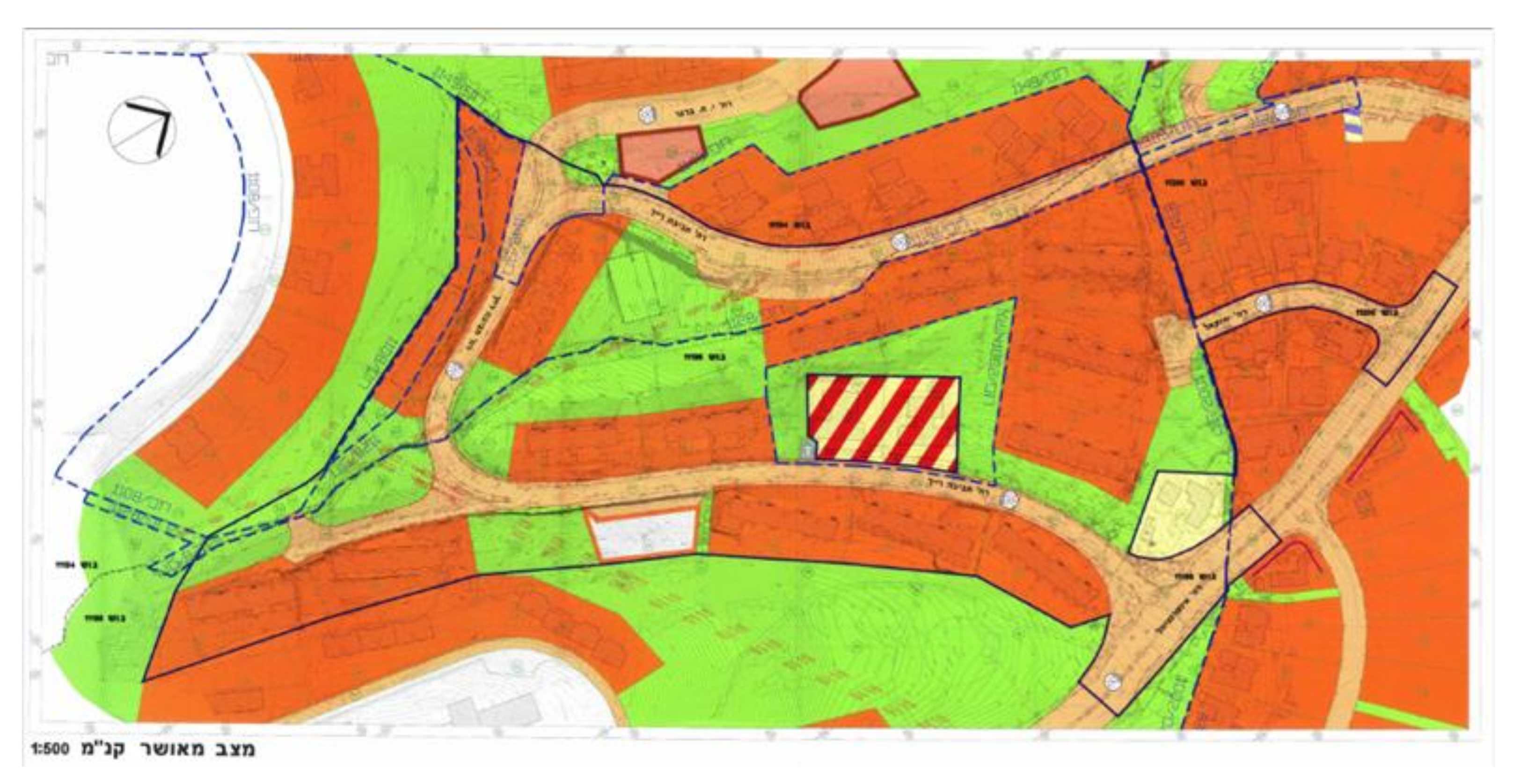
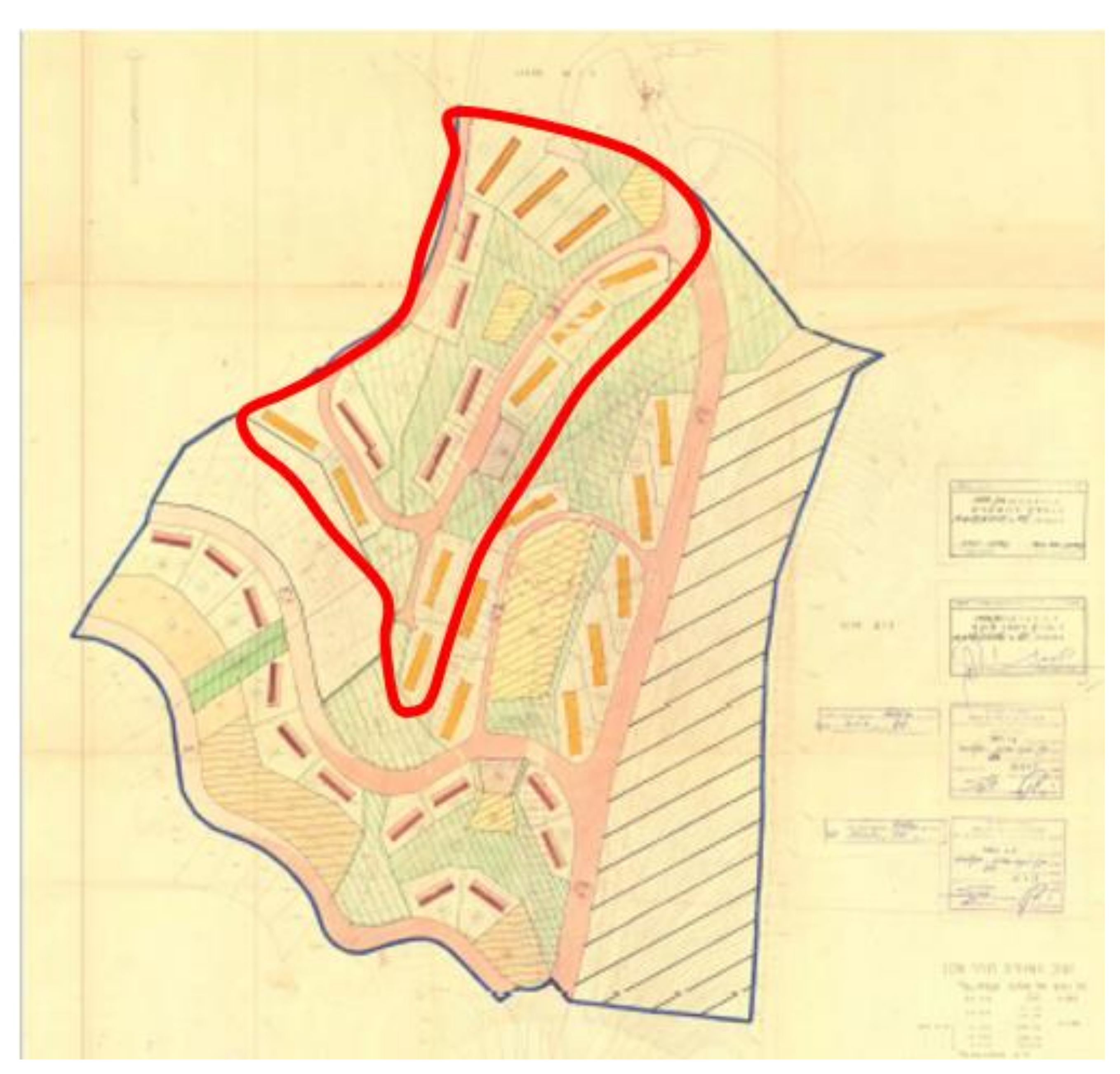
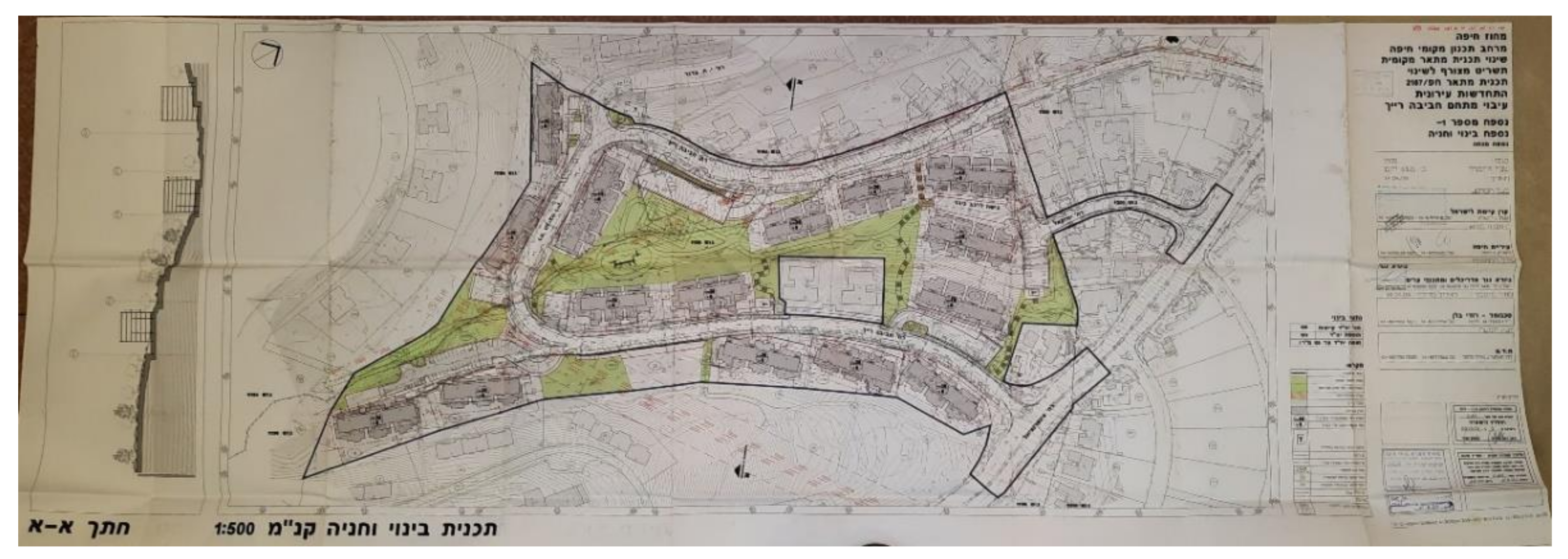
The renewal plan (
Figure 4) indicates that 15 three- to four-–story buildings located around Haviva Reich St. Site are earmarked for renewal. The open area between the buildings, so important in the original regulations, was dramatically reduced and only the open area located at the heart of the neighborhood remained.
The physical mechanism of the neighborhood’s renewal was found appropriate by the Ministry of Housing, and the municipality was
condensation of construction: reinforcing the building against earthquakes, expanding the existing apartments, and adding three floors to the original building in order to double the number of housing units. At the same time, the natural area around the buildings would be redesigned and replaced by parking areas (
Figure 5).
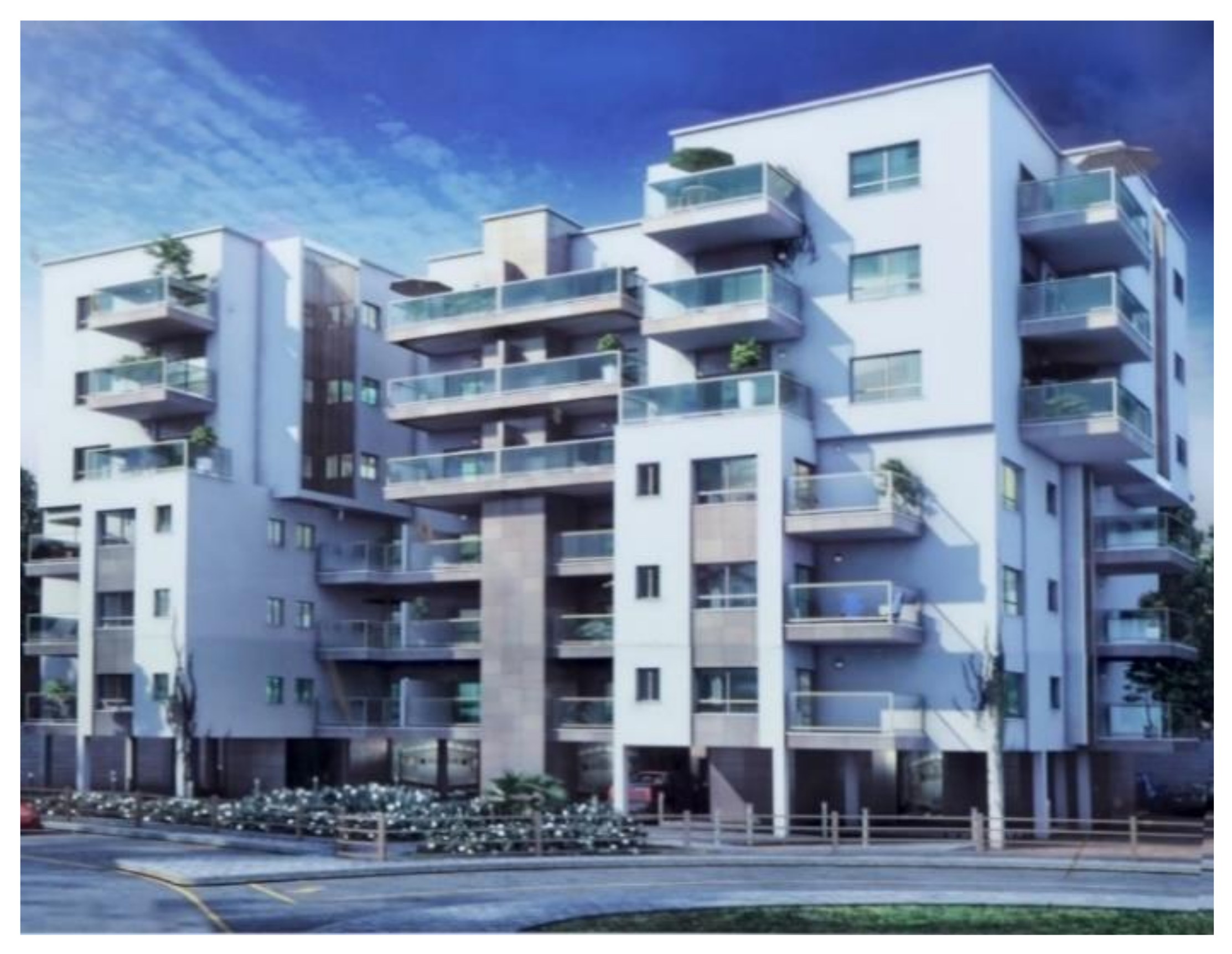
The economic mechanism relied on private entrepreneurs, as suggested in the Introduction, with their profits coming from the sale of the new apartments built over the roof of the original building [
1] (pp. 257–259) (
Figure 6). Despite protests by the Society for the Protection of Nature in Israel, given that the area included a nature reserve, as well as by some of the tenants and the project neighbors,
2 the plan went ahead. The municipality held that the plan granted the residents additional construction permits and that the tenants could decide for themselves whether to adopt or reject the opportunity [
38]. On 4 July 2005, its dedicated subcommittee rejected most of the 230 appeals against the project.
3Despite the fact that this was one plan, several contractors were involved. The procedure unfolded between the various contractors and the tenants, such as each of the former contracted with the owners of a single building: 18 owners in the three-story buildings and 32 in the four-story buildings. After one building at the edge of the neighborhood had been redeveloped, the contractors decided, with the municipality’s approval, that in terms of reinforcement against earthquakes it would be safer and more profitable to raze the old buildings and to build new ones instead, and so it was done. In 2007, the plan was updated to that affect, also enabling the addition of extra floors. The plan stipulated that in the renewed buildings, five or six extra floors could be added above the open ground story, up to a maximal height of 27 meters. This created a “grey area”, which provided the plan with flexibility, in practice enabling the contractors to build up to nine floors, which is the maximum for 27 meters. Needless to say, the effects on the street cross-section and building density were immense (
Figure 7).
What has enabled such significant revisions in the plan? The explanation is not found in the plan documents, but it may be that the implementation of TAMA 38 in 2005 is an important factor. Recall that the objective of TAMA 38 is to encourage the tenants of old buildings to reinforce their building against earthquakes by providing them with an economic incentive in the form of extensive construction permits. Ever since its approval, TAMA 38 has become central to any urban renewal project given the significant profits it offers, and in Israel’s major cities, TAMA 38 projects have become virtually ubiquitous [
39]. Apparently, both the contractors and the municipality viewed the future redeveloped buildings as a starting point for gaining the additional construction permits under TAMA 38.
Consequently, the neighborhood’s original three- to four-story buildings turned into nine-story buildings in a heartbeat. The number of housing units was tripled, and each existing old building was replaced by a new building. In the process, the open public space around the buildings was not taken into consideration, and the neighborhood plan was not revised in accordance with these changes in terms of public needs in infrastructures under the municipality’s responsibility. Every contractor saw to the “own” building”, and public space remained orphaned.
3. Results: Urban Values following the Renewal
3.1. The Quantitative Evaluation of the New Construction
Our urban quantitative examination of the characteristics of the neighborhood’s open space suggests that multiple aspects have undergone massive change. They include the following.
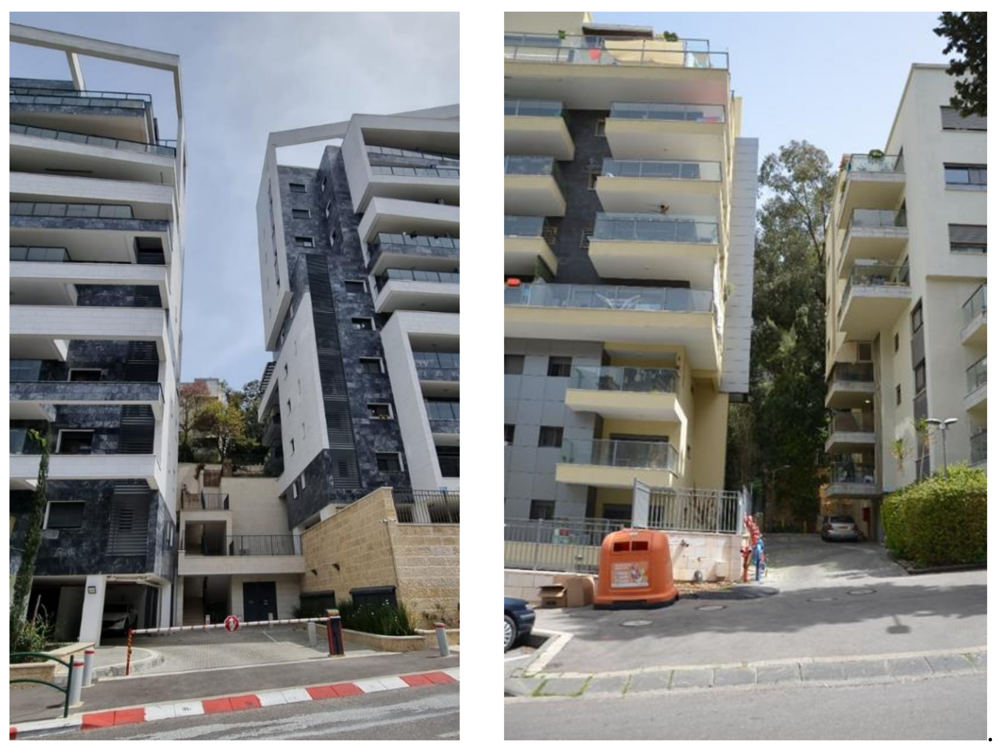
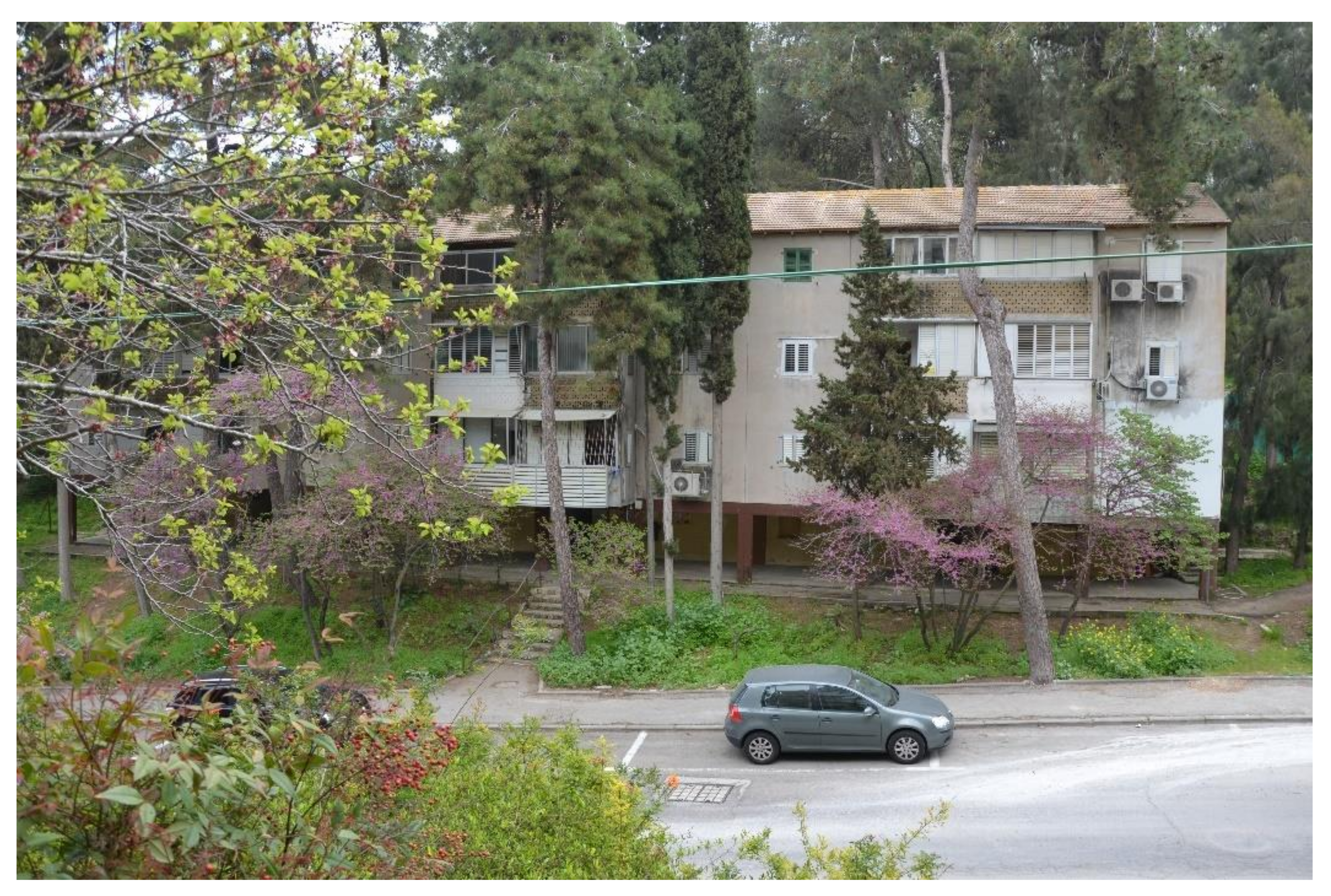
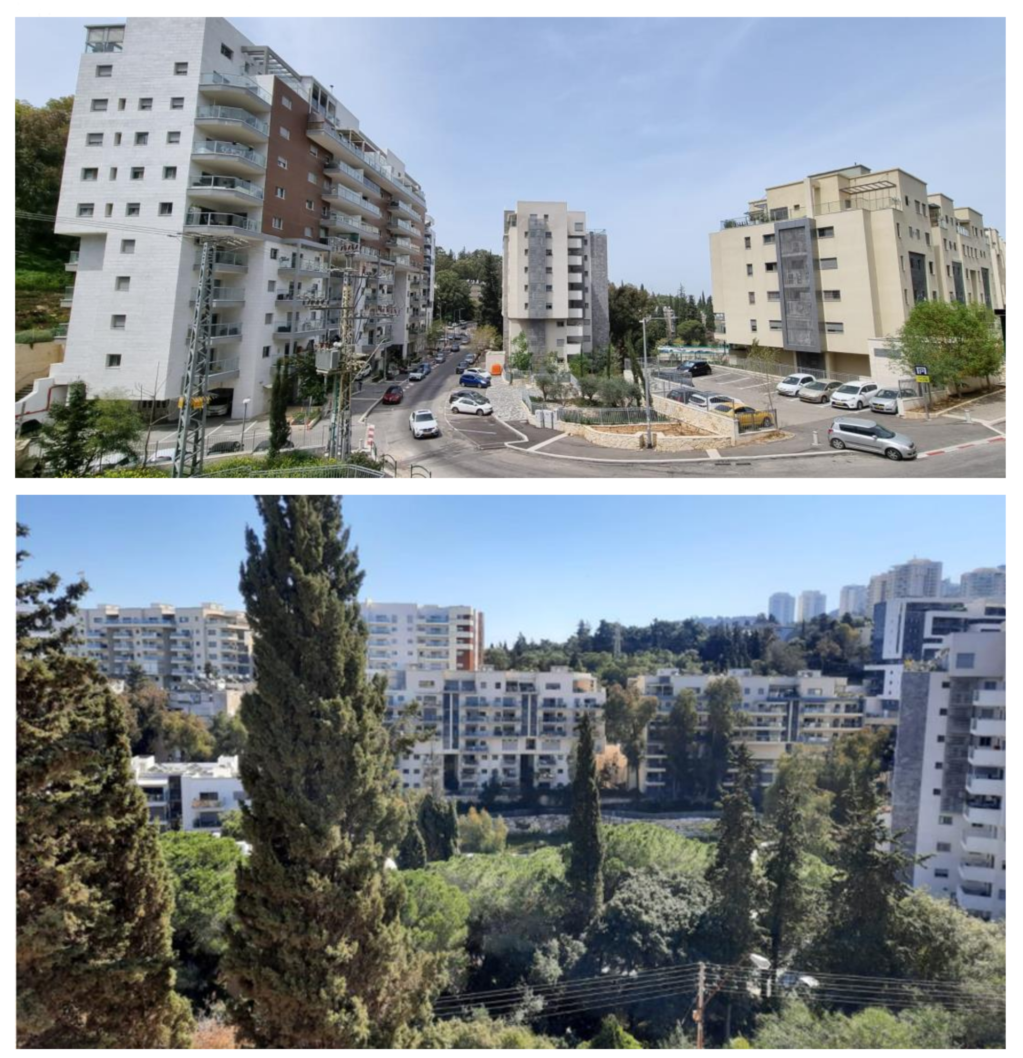
Increased building density—as mentioned, the number of housing units tripled. Consequently, a key phenomenon noticeable when walking through the neighborhood, as well as when observing it from a distance, is the density of new construction, which “closes in” on the road user from every direction. Nine-story buildings replaced the old ones, with more extensive building cover, and gaps as narrow as 4–5 meters between them, right up to the street line, without green fences or a significant open area. These buildings serve as “walls” that conceal what has remained of the natural forest, and in addition block the sunlight (
Figure 8).
Decreased green areas—many green spaces were converted into residential areas, roads, and parking spots. Consequently, much of the land area has become impermeable, and many trees were uprooted. Note that this outcome is not preordained. Proper care for some of the trees during the reconstruction would have left much of the neighborhood’s natural resources and old character intact, for the enjoyment of future generations (
Figure 9).
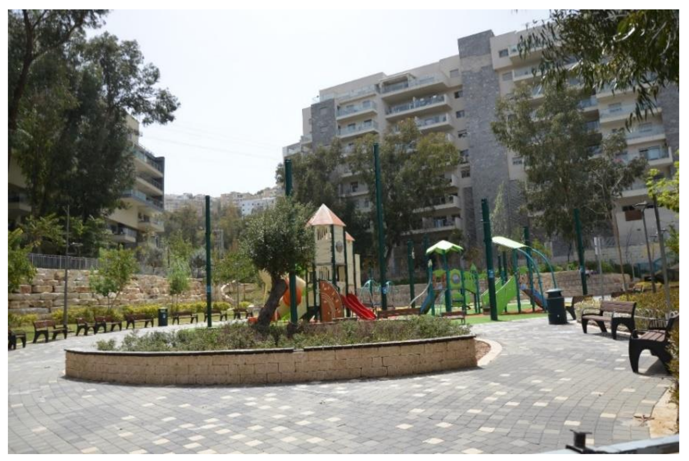
Decreased non-green open spaces—at the time of writing, development works in the public area have begun, and it appears no sports courts will be built as stipulated by the program, but instead a children’s playground will be on part of the main open public area. In addition, very few trees remained in that area, and due to their topographic location, their public benefit has been reduced (
Figure 10). Open public areas allowing encounters between the neighborhood residents, whose numbers have increased, are sorely lacking, and the wide-open areas have decreased, as have the gaps between the buildings, the walkways, and stairs.
Lack of public buildings and mixed uses—already at the planning stage, there was no reference to essential public services, which became all the more so after adding the new housing units. No public buildings, such as kindergartens, classrooms or clinics, were added to serve the new residents; nor were sources of employment such as commerce of office buildings created; and no mixed uses were planned to enable small businesses to operate within the neighborhood. Consequently, the neighborhood residents were forced to consume services in adjacent neighborhoods. Although the municipality was partner to the planning and approved the additional population, it did not require this from the contractors. The additional statutory body responsible for approving the plan, the District Committee, also did not find it appropriate to require such uses as a condition for approving construction.
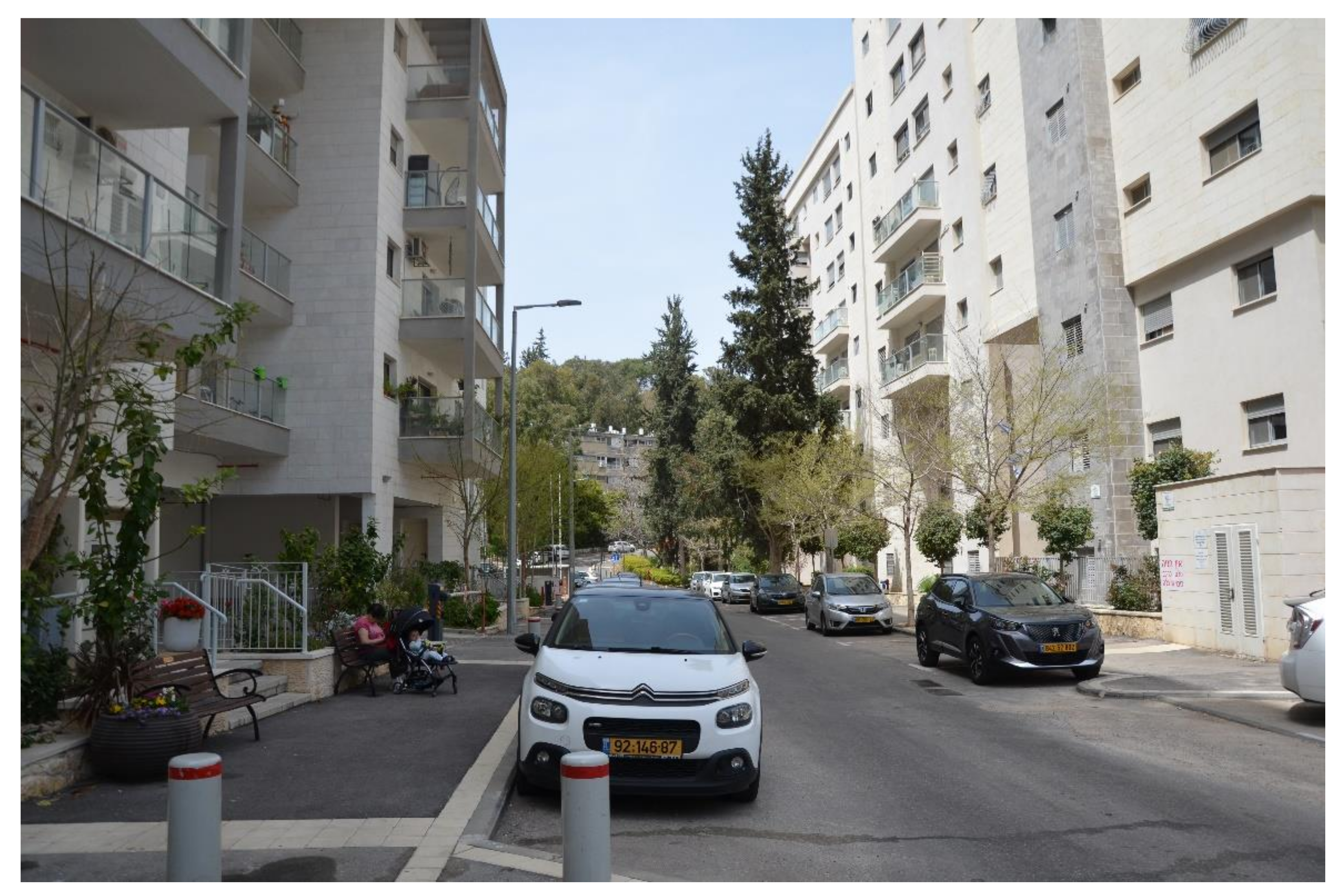
Walkability—the allocation of significant spaces for parking on the street has narrowed the sidewalks to the point where families with children or elderly people find it difficult to walk. The small number of benches along the street makes the latter’s life difficult. The lack of mixed uses along the streets, moreover, does not encourage walking, and in any case, the narrow street does not enable developing bicycle lanes, green strips, and broad pedestrian pathways (
Figure 11). Since the terrain of the neighborhood is sloped, many parents tend to drive their children to and from the elementary school in the site area, resulting in traffic jams at the entrance to the street every morning and noon.
Public transportation—a review of the routs and frequencies of public transportation prior to and after the renewal, comparing 2012 with 330 housing units to 2017 with 930, suggests little significant change. Despite the fact that a section leading to the nearby commercial center was added to the bus routes, the number of drives along the streets remained unchanged, since the bus frequency remained unchanged. Due to the increased population, this means that the importance of private vehicles for mobility in mountainous Haifa has remained unchanged.
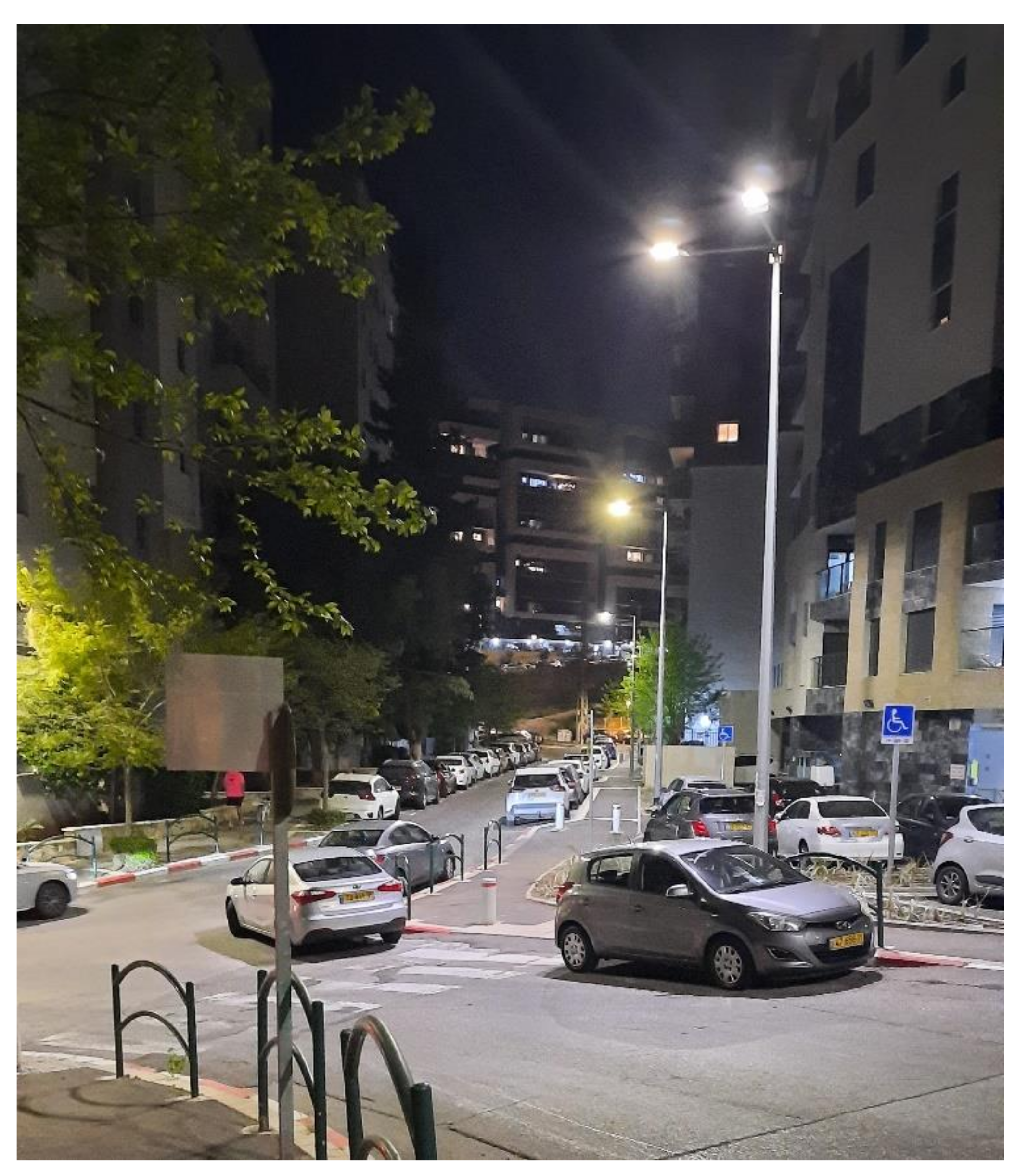
Parking shortage—given the lack of a public alternative and the low walkability in the neighborhood, private vehicles have become all-important. Each family has at least one private vehicle. Nevertheless, the neighborhood suffers from a severe shortage in parking spaces, affecting the resident’s quality of life. Talks with local residents indicate that some avoid using their cars during the day so as not to be left without parking at night (
Figure 12).
At the time when the plan was drawn, the municipal parking standard was one parking spot for a 120 square-meter apartment, and 1.3 spots for a larger apartment [
40]. As construction in the street progressed, the municipality decided that no parking spots would be added along the street for the existing housing units (similar to plans subject to TAMA 38), and that only one spot will be allocated for every additional unit. Since parking was lacking for the 300 original units, and since the contractors were granted reliefs from the municipality in terms of parking requirements, immediate shortage was created.
The municipality has built a public parking lot for some 50 cars, but this is far from meeting the neighborhood’s needs given the addition of some 600 housing units. In response, the municipality said that two more parking lots may be built, but the land area for those was not allocated yet. Given the steep terrain, it is unclear why the municipality has not required the entrepreneurs to build underground parking lots. In practice, the parking shortage on the street is one of the project’s most significant failures.
Gentrification—prior to the urban renewal, most of the population was made up of students renting apartments and relatively older population. Upon the improvement in the quality of housing and the expansion of existing units, a gentrification process began, characterized by the influx of many young families whose socioeconomic status was higher than that of the original population. The first to be pushed out of the neighborhood were the students, who could no longer afford the rent of the new apartments.
Unphased construction—as the municipality wanted to execute the plan quickly, no phasing was defined, that is, no conditions were stipulated making the construction of a certain building contingent on the completion of others. In addition, interviews with key municipal officials suggested that there was considerable uncertainty regarding the timing of execution, for each building separately, due to the selection of separate contractors for each building, and for the entire street. The plan was approved in 2006, but its implementation began only in 2011. During those 5 years nothing happened, but as the works began, requests for construction permits mounted quickly. Multiple construction sites sprung up all over the streets, and 13 out of the 15 buildings were completed within a mere 7 years. This resulted in multiple safety hazards during an extended period: the public space was taken over by the contractors, and those housing the completed buildings suffered from noise, truck congestion, and partly completed sidewalks.
To conclude, in quantitative terms, construction in the neighborhood became denser. Although this has a positive aspect in terms of sustainable urbanity, the quality of the public open space has fallen on all accounts, including the shrinking open space between the building, the public space that has lost much of its greenness, the inadequacy of other public spaces, the lack of mixed uses, the unimproved walkability, the shortage in effective public transportation, and the difficulties of using private vehicles. It should be noted that the authorities do not take responsibility as it was transferred to the private sector, so the complex is neglected in these areas as well. Finally, the students who used to live in the neighborhood were pushed out.
3.2. The Values Underpinning the New Construction
Whereas previously the values informing the neighborhood construction were modesty, equality, attachment to the land, and a cohesive community, the essence of the project now became improving the standard of housing of the individual tenant. Instead of an old two-bedroom apartment, the neighborhood residents now owned a new four-bedroom apartment. Instead of a building that would not have withstood an earthquake, they now had a new and resilient one.
Moreover, the new apartments are still highly similar, but this is no longer inspired by the value of equality, since that value has become irrelevant for the privatized. There is also no point in talking about modesty, since the very quality of the new construction is informed by capitalist values, which view the residential property as a visible part of the individual’s status. Finally, the values of community cohesion and attachment to the land and nature were completely abandoned, since there is no longer a need for social cohesion on the national level, whereas on the local level, the original community has become integrated with the new tenants. Natural values, as well as many of the common public areas, were abandoned for the new construction.
Thus, only two values in the neighborhood are: the tenants’ individualism, both in contracting with the builders and in upgrading their apartments, and thus their future capital, and more generally, capitalism. The entrepreneurial and individual profits from the upgrading of the apartment became everything. Indeed, in this historical phase as well, the planning and execution reflect the values of Israeli society.
4. Discussion and Conclusions
The article in this issue represents another step in the growing research activity on urban, cultural, social, and economic renewal [
27,
30,
32,
33]; architecture [
28,
29]; and conservation [
31]. Although our case study is located in Israel, the lessons we can learn from the study go beyond the boundaries of the state and society. We emphasize urban renewal funded by private entrepreneurs only.
Israeli society has become completely transformed between the planning and construction of the public housing project in the late 1950s and the urban renewal of the second decade of the 2000s. From a close-knot community guided both socially and normatively by a strong, statist government, Israel became heterogeneous and polarized, with its government having some, but limited effect on its character. The private market, almost negligible in importance upon the establishment of Israel, became a significant force in the 21st century, and the cultural hegemony of European socialism was succeeded by American capitalism.
The urban renewal project examined concretely articulates these transformations. Small apartments were replaced by bigger ones and natural green areas by concrete. Public housing was replaced by private contractors. Accordingly, there may be no point in bemoaning the values lost in the renewal project. Society has changed, and with it the residents’ preferences and conduct. The values of the past are no longer relevant, and there is no point in tracing them in the renewal project.
Nevertheless, the absence of a public authority and of public capital, although aligned with the privatization policy and individualist, capitalist ideology, significantly reduce the qualities of the project under study, and of other urban processes in privatized contexts. Exclusive reliance on private capital places the entrepreneurial interest at the top of the project’s priorities, at the expense of the public interest, public oversight, and public investment. The new apartments may be of higher quality, but the quality of residence in the entire neighborhood with(out) its public services and spaces, suffers, as noted by the residents.
In fact, the very choice of the site under study for urban renewal lacked urban considerations. No main urban arteries were selected for the new construction to ensure maximal access, the street cross section did not enable sun rights, and the density was not utilized to maximize mixed uses and benefit the entire neighborhood. The only consideration was entrepreneurial profit; hence, the number of housing units was tripled. Consequently, narrow, peripheral streets that were not widened became overcrowded, additional uses remained outside the neighborhood, and public services were not made available. The quality of the green spaces suffered, as did open public areas, and the space between buildings shrunk. No walking routes were added, and the bus routes remained the same, as did their frequency, despite the increased number of passengers. The number of parking spots did not rise in keeping with the huge increase in cars. The only ray of light was the vistas afforded to some of the apartments on the upper floors.
Since the tenants of each building worked with separate contractors, there was no single coordinating agency or individual who had a holistic view of the complex space. The municipality also failed to contribute in that regard. In other words, the renewal was not accompanied by any public investment, nor where the entrepreneurs under any obligation to see to service development.
This is also part of the reason for the project’s failure in terms of neighborhood’s liveliness and resilience over the long term and sustainability. First, its apartments are designated almost exclusively for families. Given the need for entrepreneurial profit, as well as personal profit for the original owners, the minimal apartment has four bedrooms, not allowing a diverse population and unsuitable for the various stages of human life. Second, given the lack of public capital and public oversight on the execution, the quality of the public space is low. It is not green enough, not permeable enough, and does not include elements able to provide respite to the neighborhood experience. Third, since no public capital is invested in transportation, the residents depend on their private vehicles, since the neighborhood lacks daily services and is not walkable. As a result, the strong population may end up abandoning the neighborhood, leading to the entry of a weaker population, deteriorated maintenance, etc. Will the neighborhood find itself destroyed and rebuilt once more in several decades’ time? Destruction, of any type, is the opposite of resilience and sustainability.
In order to ensure the well-being of all participants in urban renewal, it will be important to continuously research the optimal interface between private and public capital and the division of powers: the investors on one hand and the residents of the neighborhood and the city on the other.
To conclude, the COVID-19 period has taught us not only the value of good urbanity—a neighborhood that contains everything and the desperate need for open, adjacent and visible areas, but also the huge importance of community resilience and the significant functions of the public authorities responsible for our health and well-being [
9]. As demonstrated above, urban renewal informed exclusively by profit margins does not serve the community and must therefore be rejected.
In order to promote the urban renewal process, a public participation process was required, and above all, learning from the inhabitants what are the neighborhood‘s’ values that should be kept after the urban renewal. This paper calls to integrate public servants and public participation in the planning, so that the public interest is given voice. We also call to allocate municipal and national funds to urban renewal to make room for other, non-capitalist interests in the planning and construction. Finally, we call for the establishment of a public body that would deal not only with the residential home and its immediate environment, but map the needs of the entire city and identify the urban sites and actions required for an optimal results. Adequate urban renewal is one whose positive echoes are felt far beyond the project site and long after the time required for the contractors to pocket their profits and proceed to the next project.


