Article

Transforming the Use of Agricultural Premises under Urbanization Pressures: A Story from a Second-Tier Post-Socialist City

by
Petr Klusáček
1,
Stanislav Martinát
2,*,
Klára Charvátová
3 and
Josef Navrátil
4
1
Faculty of Regional Development and International Studies, Mendel University, Třída Generála Píky 2005/7, 61300 Brno, Czech Republic
2
Social, Economic and Geographic Sciences Group, The James Hutton Institute, Aberdeen AB15 8QH, UK
3
Department of Regional Economics and Administration, Faculty of Economics and Administration, Masaryk University, 60200 Brno, Czech Republic
4
Faculty of Natural Sciences, Institute of Social and Economic Geography and Spatial Management, University of Silesia in Katowice, Będzińska 60, 41-205 Sosnowiec, Poland
*
Author to whom correspondence should be addressed.
Land 2022, 11(6), 866; https://doi.org/10.3390/land11060866
Submission received: 30 April 2022 / Revised: 27 May 2022 / Accepted: 7 June 2022 / Published: 8 June 2022
(This article belongs to the Special Issue Rural Land Management Interaction with Urbanization)

Abstract

:
Diverse aspects of de-agrarianization, which is manifested by the cessation or significant reduction in agricultural activities, have been clearly visible at the outskirts of large cities in Central Europe in recent decades. The key drivers behind this process include increased pressures to cover peri-urban agricultural land by new developments, inadequate protection of agricultural land, ineffective implementation of urban planning policies, low recognition of the importance of agriculture, and overall changes in people’s dietary habits. Urbanization pressures undoubtedly belong to the factors intensifying overall de-agrarianization, as urban farmers are usually not able to compete with other urban functions. This article focuses on more in-depth understanding of the driving forces behind de-agrarianization processes that are specific to post-socialist cities. As a case study, Brno, a second-tier city in the Czech Republic, was selected. In the first part, the conceptual framework and drivers of de-agrarianization are discussed specifically for the case of large Central European post-socialist cities. In the next part, we explore by means of a set of qualitative interviews the case study of the regeneration of the area of a former Cistercian monastery in Brno that was traditionally used for agricultural purposes, but recently was redeveloped for a university campus. Our findings signal procedural issues connected to the preservation of architectural heritage during the regeneration that frequently end up with only fragments being preserved. We also demonstrate a decline in the use of urban agricultural properties that are hastily transformed into a new urban environment under extremely strong urbanization pressures. We argue that even in economically prosperous cities with highly neoliberal competition between possible urban land uses, agriculture must be considered a relevant and highly important urban function and more protected by planning tools.

1. Introduction

The utilization of land in contemporary neoliberal cities is fundamentally driven by market relations [1], which tend to crowd out and displace functions that bring lower rent [2]. This is especially true in post-socialist cities [3], where competition for land was highly deformed for the majority of the second half of the 20th century during the era of socialism [4]. On the contrary, the post-socialist era after 1990 has rapidly brought even more extreme market-related pressures searching for new spaces for new uses and re-uses of urban land [5]. The governance of post-socialist cities is slowly adapting to new challenges to which that it has not yet been exposed [6,7].

1.1. Factors Affecting Urban Agriculture in Central European Cities

Among the urban functions that found themselves in highly precarious and hardly competitive positions in the new era after the 1990s is agriculture [8]. Over the course of the last three decades, urban and peri-urban agriculture has begun to rapidly disappear from post-socialist cities, being replaced by more economically profitable activities, regardless of the benefits and social and environmental potential that agriculture represents for urban dwellers [9]. Undoubtedly, the main drivers of de-agrarianization in Central European cities, which is manifested by the cessation or significant reduction in agricultural activities [10], include, for example: (i) emerging large-scale urbanization pressures to cover peri-urban land with new developments, (ii) the import of agricultural products from countries (regions) where they can be produced at cheaper prices and thus render local producers unable to compete [11], (iii) a change in the dietary habits of the population [12] (e.g., a decline in the popularity of dairy products), (iv) prioritization of more profitable urban land uses by owners [13], (v) inadequate urban planning policies [14], (vi) reduced attractiveness of the agricultural sector for new entrants [15], and (vii) low acknowledgement of the importance of urban agriculture [16]. All these driving forces have contributed to a drastic reduction in agricultural activities in urban areas in the last three decades.
On the other hand, the growing attractiveness of small-scale and rather lifestyle oriented urban agriculture among urban dwellers can be clearly observed [17]. Diverse forms of urban agriculture are emerging from the roots of local food initiatives. Numerous types and varieties of allotment gardening that survived the pressures of the urban post-socialist transition are thriving [18]. The social, cultural, and environmental benefits of urban agriculture for urbanites are confirmed by numerous studies (e.g., [19,20]).
General urbanization (and especially suburbanization) pressures are undoubtedly one of the underlying factors [21] that amplify overall urban de-agrarianization from a spatial perspective [22,23] as agricultural activities are usually unable to compete with expanding urban functions [24]. Contrarily, de-agrarianization does not seem to be solely concentrated in urban space or immediately proximal to it but is also detectable in areas with a poor quality of land and distant rural locations. In this case, it would be more appropriate to use the term de-intensification [25] as some kind of land management is still possible and the change in the usage of land is not irreversible [26]. The paths towards both aforementioned processes are mutually interlinked, although the motivations of land managers in cities and rural peripheries differ [27].

1.2. Urban Agricultural and Territorial Delimitation of Cities

The on-site situation and intensity of urban agriculture is certainly site-specific; however, it seems to be heavily influenced by a territorial delimitation of the city’s administrative boundaries [28]. Here is where urban planning policies towards urban agriculture become enormously important [29] and can play a leading role in promoting the agricultural use of land in cities [30]. While some cities have outgrown their administrative boundaries by the size of their built-up area, in other cities the administrative boundaries have been defined in a more generous way [31], so that rural areas and the presence of undeveloped land in the form of agricultural or forest land have been placed under the local self-government of the city. This discrepancy between administrative boundaries and functional regions has been discussed in more detail by [32]. In the post-socialist environment, it is usually the case that towns have been defined more broadly [33,34]. The rationale for this phenomenon can be found in the era of a centrally controlled economy, where food self-sufficiency was among the key national strategies and thus was projected by the emergence of urban (or peri-urban) agriculture on the local level [18]. We can build on this tradition when supporting local food systems. The link towards sustainability seems to be clear as local agricultural production supplying urban dwellers with a supply of fresh food is inevitable for building healthier and more sustainable life in cities [35,36].

1.3. Brownfield Regeneration in Brno

We need to shift our attention now to better comprehend the context of our case study located in Brno, which is the second most populated city in the Czech Republic (population 379.5 thousand in 2022). In the period after 1989, when the post-socialist era started, agriculture in Brno underwent turbulent and complex transformation processes. These can be clearly manifested in a dramatic change in the scope and scale of local urban agricultural production. More specifically, for example, a traditional greenhouse-type of urban agriculture quickly disappeared due a lack of competitiveness with cheaper food imports and found itself largely abandoned. Additionally, large urban developments were built on soils of high quality, which were irreversibly lost. More than 800 hectares of agricultural land, i.e., circa 3% of the city area, has lost its agricultural function in the last three decades. Another important factor that has contributed to such a shift is changing legal relations concerning land use [37]. Large-scale agricultural cooperatives that were created in the socialist era disappeared in most cases and were replaced by other types of business-driven entities by means of privatizations and restitutions of agricultural properties [38]. In short, both residential and commercial suburbanization and consequent urban sprawl had an immense impact on the scale of the loss of agricultural land and urban expansion at the expense of open landscape [39,40]. These processes naturally led to the change in function of numerous urban and peri-urban agricultural properties and the creation of abandoned agricultural brownfields [41,42]. Unfortunately, after the reintroduction of the market economy in the Brno urban environment, only minor agricultural activities were preserved and economically strong enough to be able to compete with more profitable urban functions. Brno inherited rather wide urban administrative boundaries from the socialist period compared to, for example, cities in neighboring Austria [43]. Therefore, the contrast between agricultural landscape and urban landscape within Brno’s city borders is still visible (Figure 1) and must be carefully maintained. Statistical data show that the decline of agricultural and arable land in Brno developed new dynamics under the conditions of the market economy since 1992, in the era of the Czech Republic (please see Table 1).
The municipality of Brno, which is the administrative center of the South Moravian Region, is actively supporting brownfield regeneration in order to reduce its occurrence. As post-agricultural brownfields can be frequently found among the abandoned sites, special effort is devoted to enabling their new use. For example, the Brno city administration together with the Regional Development Agency of South Moravia have created specialized databases of non-regenerated brownfields, published successfully regenerated brownfields, and organized workshops for stakeholders, and are much more successful in this area compared to other regional cities and regions of the Czech Republic [6]. These databases were used for development and testing of the TIMBRE brownfield prioritization tool [44,45]. Quantitative surveys of available data [46,47] have shown that brownfields can usually successfully compete with greenfields, especially in core residential areas and in locations well connected to major transport networks. The research focused on examples of good practice in successfully regenerated brownfields in Brno [4,48] and other places in the South Moravian Region (Czech Republic) [23,49] showed that in terms of specific case sites networking is important.
This article focuses on enabling an advanced understanding of the brownfield regeneration process as an expression of a long-term de-agrarianization. As a case study, Brno, a second-tier post-socialist city in the Czech Republic, was selected. We employed qualitative research methods to better understand the particularities of the regeneration of a former Cistercian monastery where agricultural activities were traditionally undertaken, but as a result of the regeneration, a new complex serving the development of higher university education (an university campus) was developed.
The main objective of the paper is to identify and interpret the main driving forces that influence long-term de-agrarianization in the urban environment in the post-socialist context.

2. Materials and Methods

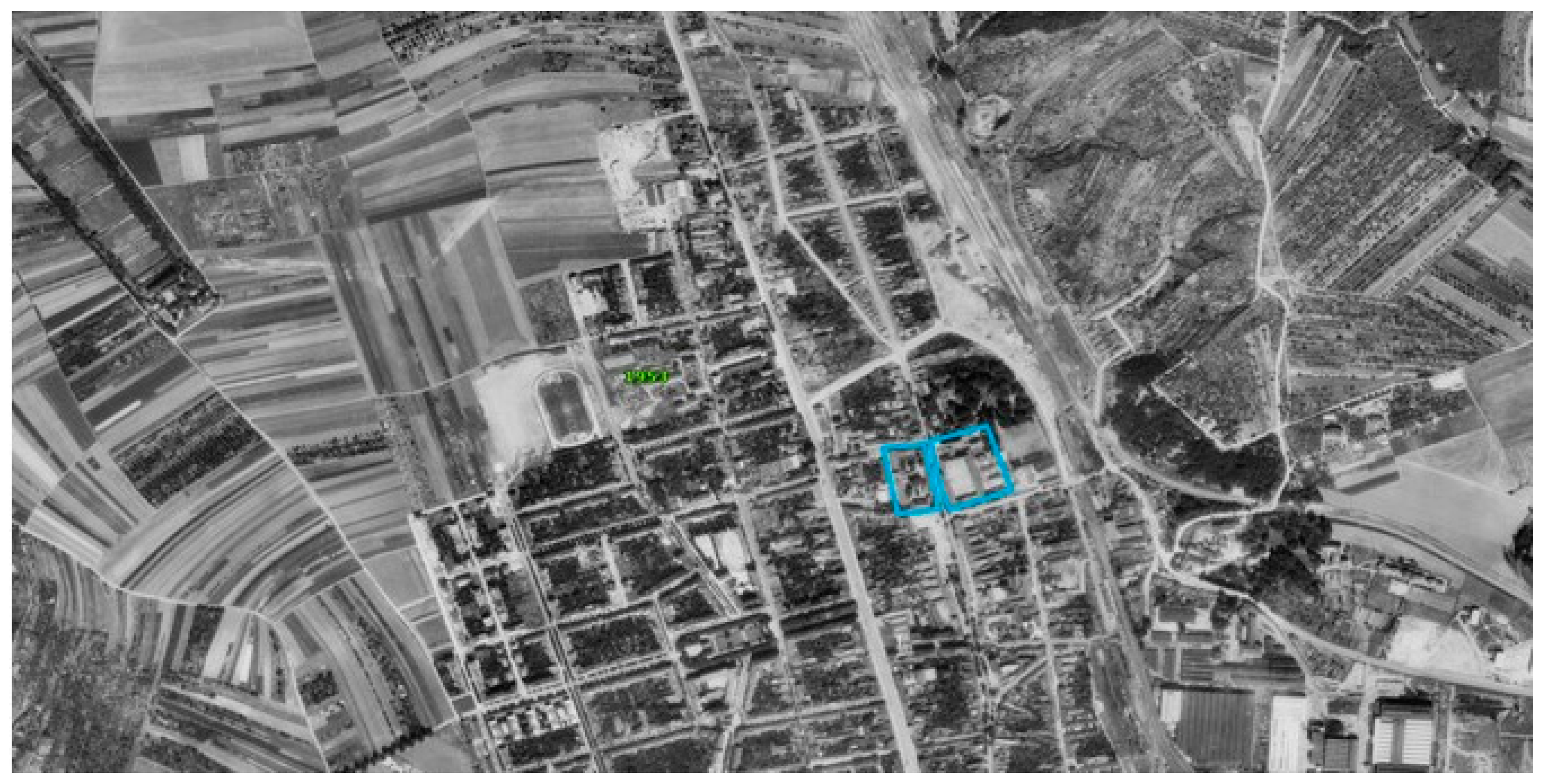
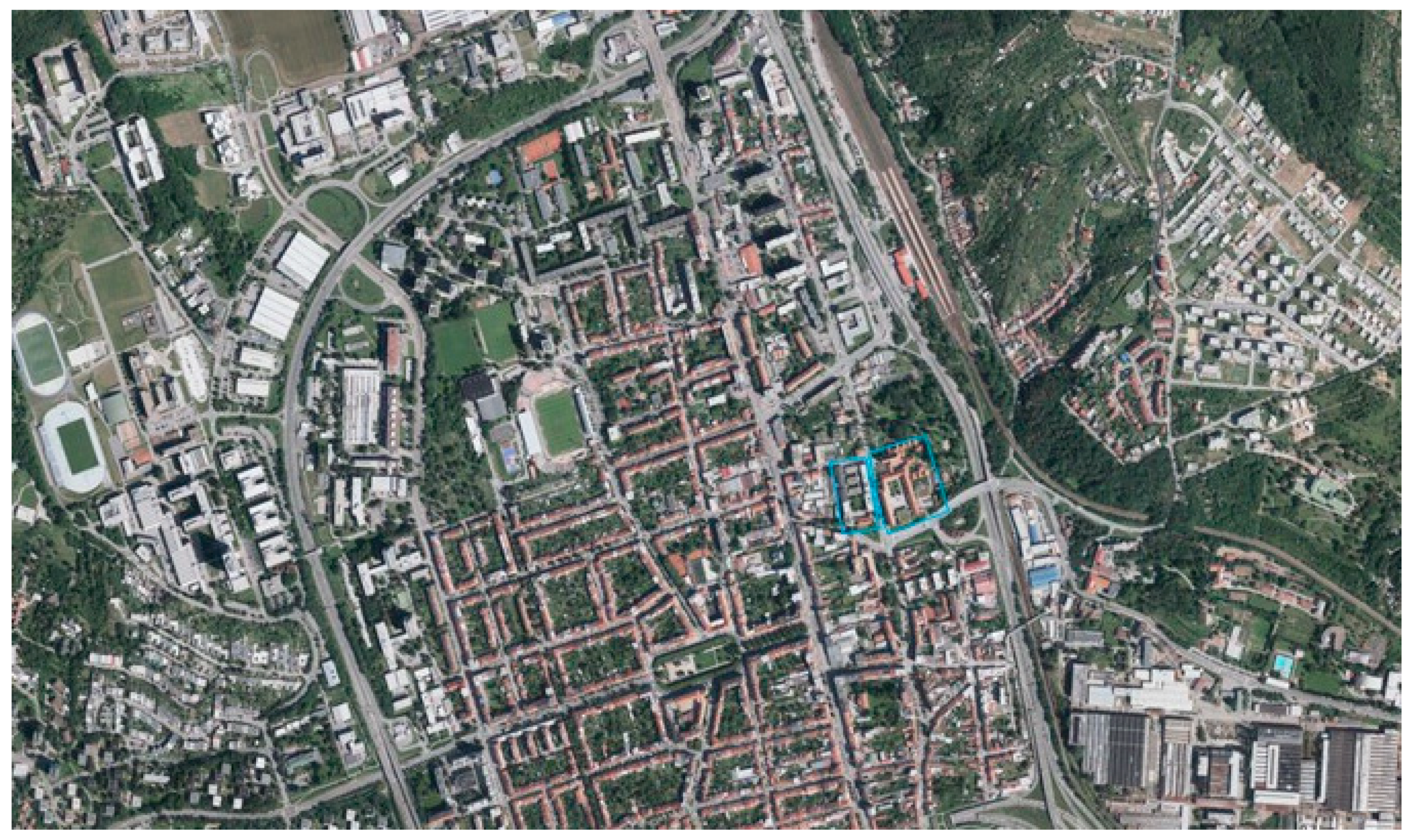
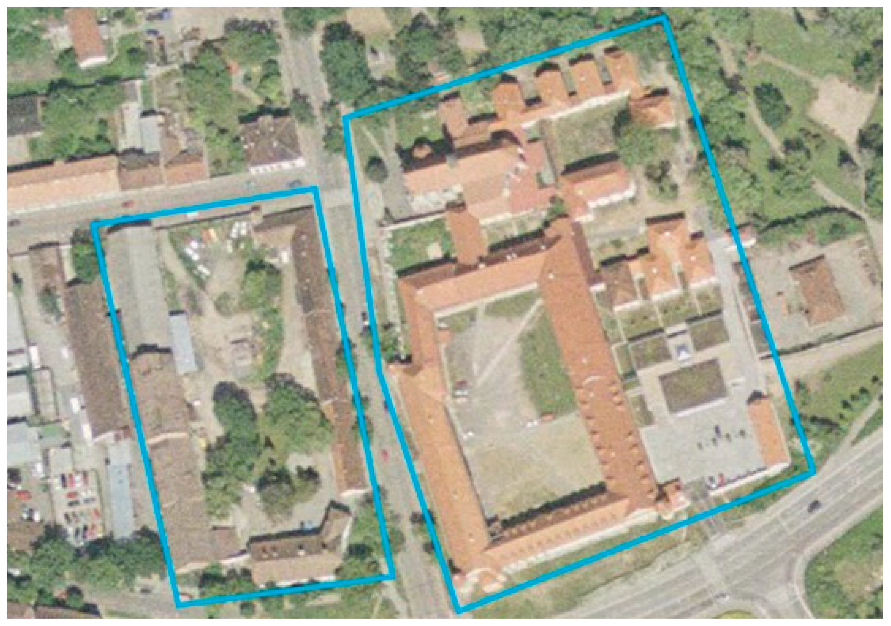
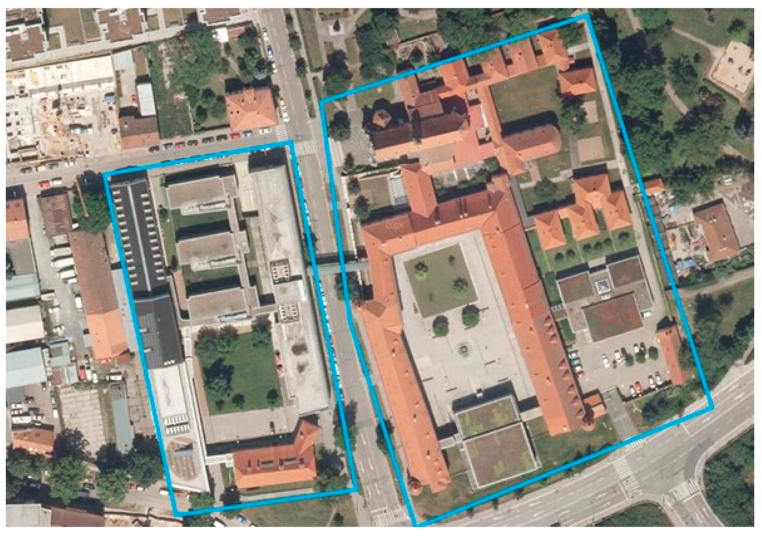
2.1. Case Study Area

Previous brownfield research in Brno primarily focused on the particularities of the spatial patterns of urban brownfield regeneration. It was discovered that post-agricultural brownfields tend to be located at the urban periphery, where facilities of peri-urban agriculture had been widely developed during the socialist era [50]. In this research, we deal with long-term de-agrarianization in Brno. We focused on the case study area of a former monastery, estate, and brewery in Brno (Královo Pole city district), which gradually lost its agricultural function during the second half of 20th century and was regenerated for an university campus [51] (pp. 31–33). The selection of the case study area was based on a wider and controversial public debate about which parts of the heritage (architectural, spiritual, agricultural) should be preserved in order to maintain the genius loci of the site. To introduce the context, the vast majority of post-agricultural brownfields in Brno were sites that had been built during the socialist era to serve the needs of intensive suburban agriculture whose architectural value was minimal. These sites, frequently constructed for a provisional use with poor quality constructions, were usually demolished after 1990 and were followed by completely newly built developments. These examples include the sites with glasshouses (e.g., [52], pp. 22–24 or pp. 37–39) or premises of former agricultural cooperatives. In the context of post-agricultural brownfields in Brno, our case study is unique and deserves a more in-depth look.
In 1953, our case study area (former monastery) was still located on the northern edge of the built-up area of Brno with abundant agricultural land in its immediate vicinity (Figure 2). In the following decades, however, intensive urbanization prevailed, leading to extensive changes in the surrounding agricultural land for urban development (please see Figure 3, which illustrates how the neighborhood changed). The case study area consists of two units: (i) the western part, which had an economic use focused primarily on the storage and processing of agricultural products, while (ii) the eastern part was historically used as a monastery (Figure 4 and Figure 5). During the regeneration of the site, which occurred in the period 2004–2014, the eastern part with the historic monastery was mostly rebuilt, while the western part was largely demolished and only remnants of agricultural architecture remained. In particular, a former malt house (Figure 6) was preserved and was incorporated into the regeneration project (Figure 7). Both campuses were interconnected by a bridge during the regeneration (Figure 8). Selected basic characteristics of the regeneration project are listed in Table 2 for better and systematic overview.
However, let us turn back to the past. The case study site has been used for agricultural purposes since the 14th century. From a long-term historical perspective, it can be stated that the regeneration project is not the first redevelopment of the site that has brought about a significant land-use change here (please details in Figure 9).

2.2. Data Collection

Our methodology is principally entrenched in the analyses of the information gathered during interviews with seven informants that were complemented by the study of collated written materials. The interviews were conducted in the first half of 2020. The interviewees were selected to represent diverse actors involved in the regeneration project (please see Table 3). All our interviews were carried out with the physical participation of both parties (online interviews were avoided) and lasted for circa two hours. All seven interviewees provided their consent to use their ideas and opinions in our research. We thoroughly informed all participants about the aims of our research, our funding, and also how the information provided will be secured so that any misuse of confidentiality is avoided. All interviews were recorded after consent. The oral recordings were subsequently transcribed and the transcripts coded and analyzed using the Atlas.ti software. To avoid any breach of anonymity, the personal information of the interviewees was stored separately in an offline repository.

3. Results

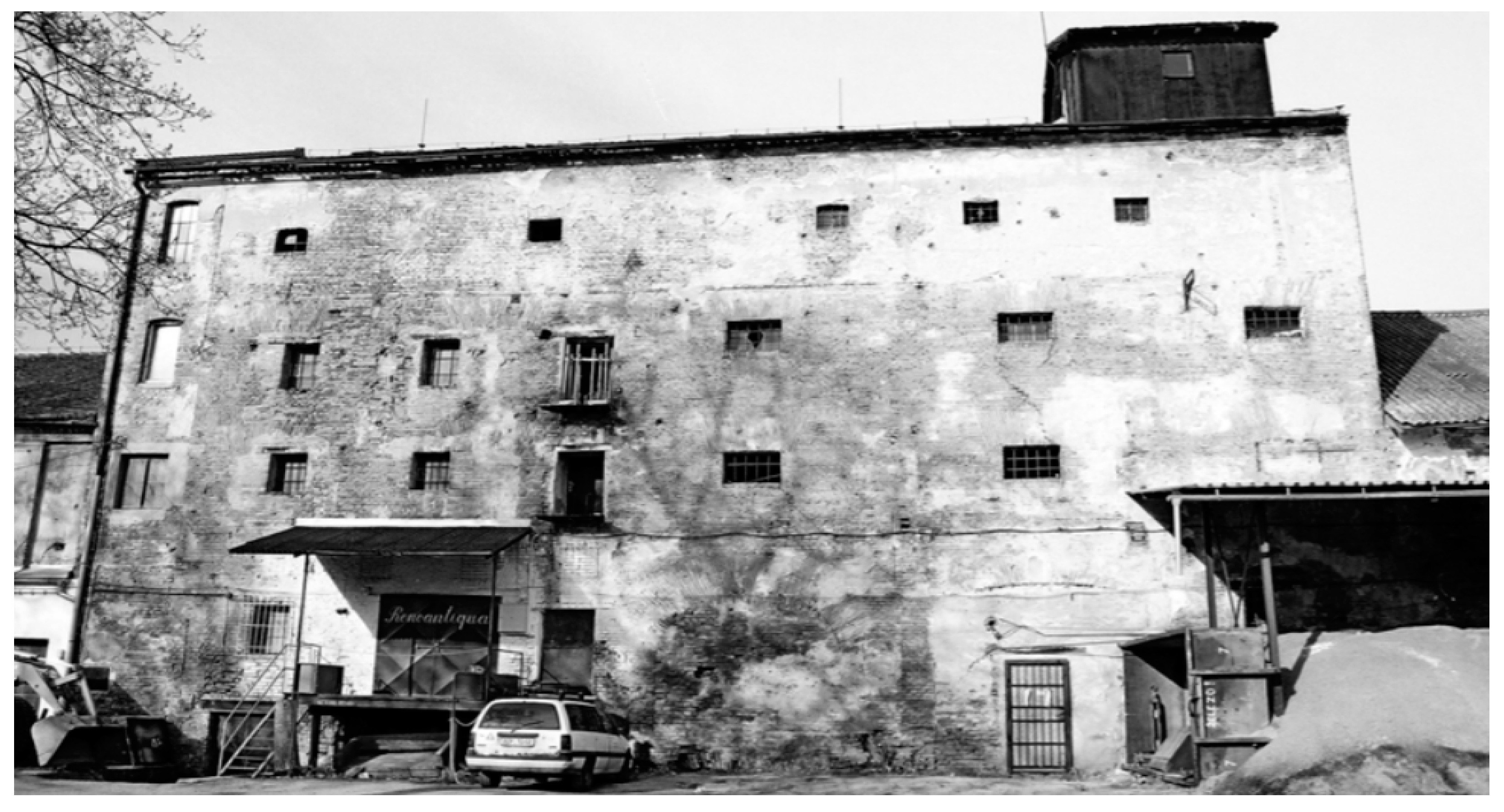
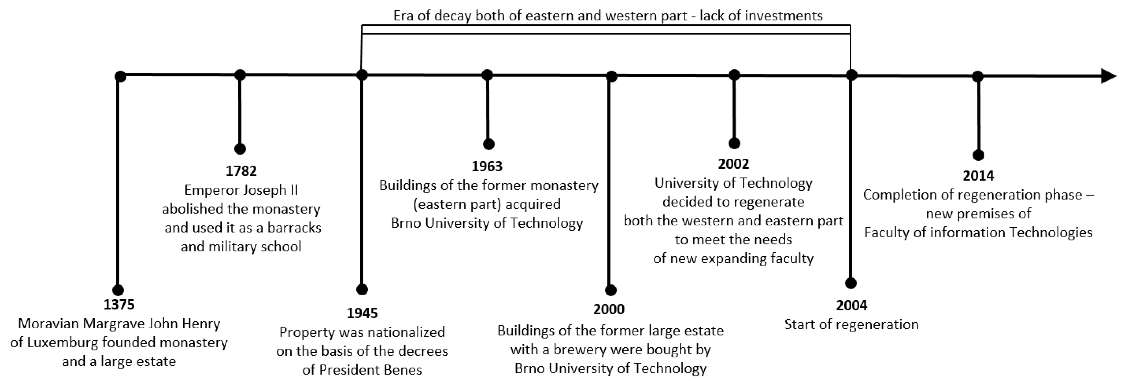
3.1. Gradual Decline of the Site during the 20th Century

The beginning of the transformation of the site from mostly agricultural to mostly urban fell in the period of the First Czechoslovak Republic, when in 1919, as part of the creation of Large Brno, Královo Pole was administratively amalgamated with Brno. According to an archeologist: “The large estate in Královo Pole functioned basically until the time of the First Republic. Land reforms of the 1920s basically allowed large landowners to interfere with the things here. However, the lands were redistributed to several owners. … The cessation of agricultural production in the area went hand in hand with the land reform and the development of the agglomeration, which was basically turning from agricultural to industrial… It’s basically a specific form of that agricultural brownfield, because it then developed within, like, an urban environment”.
In the period after 1945 the site was completely nationalized. The Communist Party had little respect for religious buildings so plenty of churches and monasteries in many places in the former Czechoslovakia were dilapidated. Fortunately, the former monastery in Brno was in a better position, because in 1963 it was handed over from the state ownership to the Brno University of Technology. The Vice Dean for Development of the university commented on this phase in the following way: “The Brno University of Technology acquired the site as a replacement for the buildings that had been confiscated by the military academy… In 1963 the Brno University of Technology acquired the premises as it was expanding its activities. Two departments, the then Faculty of Electrical Engineering, namely the Department of Automatic Computers and the Department of Automation, were relocated here from the city center. … The Technical University got that campus in very bad, derelict shape”. The mayor of city district where the site is situated described the era in the following way: “Basically, from 1963 to 1992 … the university had a million here and there, which wasn’t even enough money to provide for all the repairs of the property”.
Brno University of Technology attempted to progress with the redevelopment, but at that time, public universities suffered from a huge lack of funds for their development. In other words, most of the funding was devoted just to the emergency maintenance of the site. The utilization of the former monastery, which had served many other purposes in the past, was complicated. Sometimes even the tuition took place in these premises, which were far from ideal. A former student described this situation: “When I managed to enter this university in 1967 as a student and we had these lectures in the former stables of the monastery, it was in one of those buildings where there was a stone trough… 200 people were supposed to fit in this room… They did fit in, but only the first 10 rows could hear and the others played cards”.
The western part of the site, which was traditionally used for processing agricultural crops, was used in various ways during the socialist era, for example, for ripening exotic fruits or as a vegetable store. Some forms of other temporary uses have been more successful and others less so, which the mayor of the city district commented upon: “There was a glass shop, there was a butcher shop that was in substandard conditions… yeah, it was in disrepair as it was…but there was a famous pub in those former goat sheds that was very popular…”.

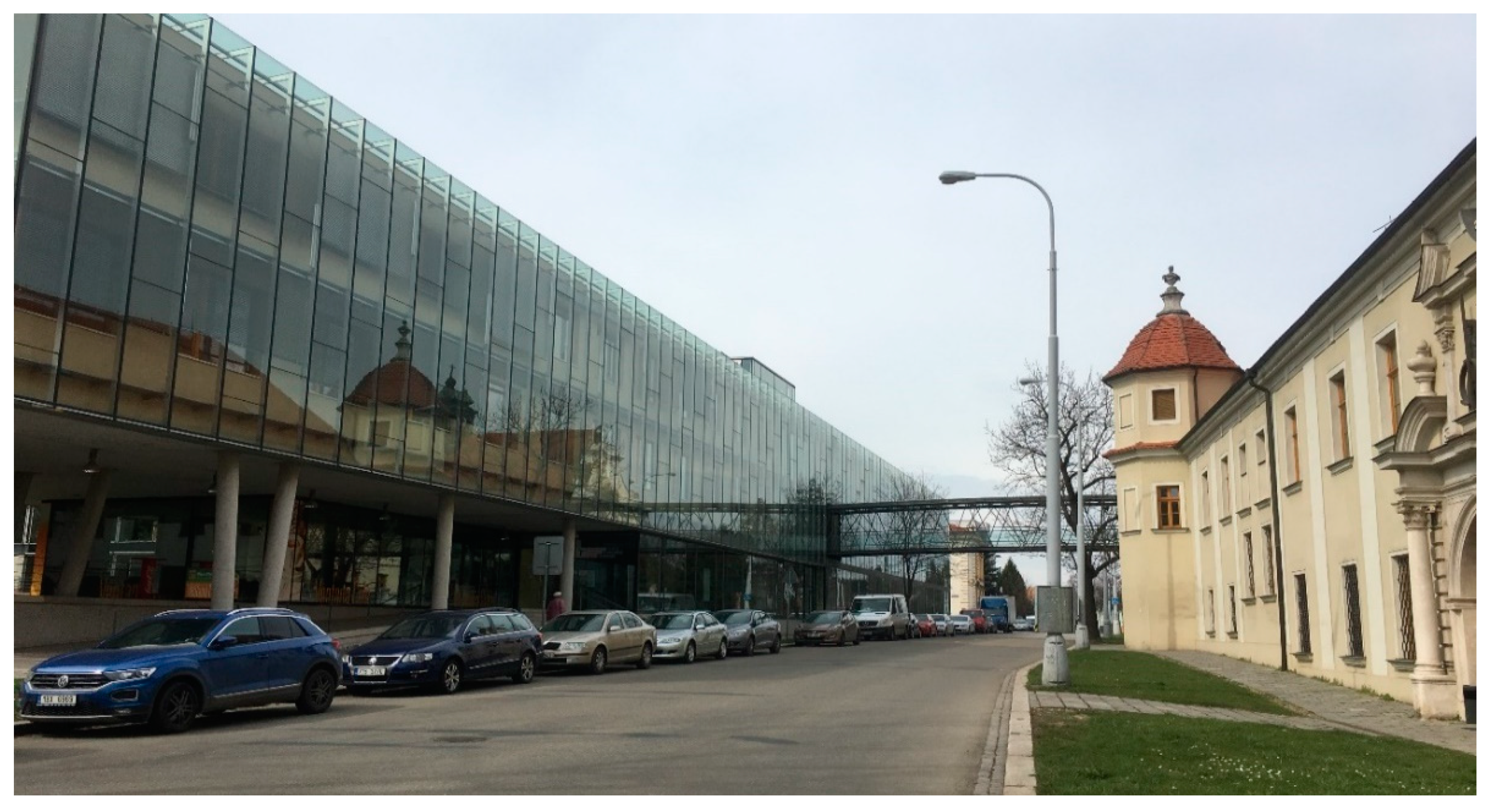
3.2. Regeneration Process and Related Issues

In the 1990s, Brno underwent an extensive transformation of its economy from a centrally planned to a market economy. This period was typified by the bankruptcy of many industrial and agricultural enterprises and the rapid growth of the service sector. State support for public universities was increased during the 1990s, which enabled investments in the redevelopment of the university’s real estate. In line with these trends, the number of students began to increase at the Faculty of Information Technology at Brno University of Technology. The Vice Dean for Development commented on the state in the following way: “We had to solve the question of how to ensure the further development of the faculty …whether we will move to the area under Palacký Hill on the outskirts of Brno or stay here in Královo Pole, but in that case we have to use the area of the former large estate”.
In the 1990s, the western part of the case study area was owned by the city, a situation the Vice Dean for Development described as follows: “So the crucial meeting was with the former mayor, who agreed with the idea of the Faculty further developing here and even said that it would be a lifesaver for the monastery, because until then we were always looking for money and it always ended up that we got a couple of million, but a couple of million here in this whole area is like spitting in the sea, yeah. It required an investment of about 800 million CZK here”. When the university became the owner of the western part of the case study area in 2000, it was the first crucial step on the road to the regeneration of the site, but number of other issues still had to be solved.
To enable the regeneration project of a former monastery, an archaeological survey had to be carried out first, which caused another delay. A survey is obligatory in areas with archaeological findings under the State Heritage Protection Act. According to the archeologist: “An investor who wants to build in such an area must notify the archaeological institute of his intention well in advance and then make arrangements with an authorized organization to carry out archaeological excavations”. Furthermore, a project for the preservation of the architectural heritage was drawn up and, in a cooperation with the heritage protection authority, the buildings that could be removed and modified were identified. The most valuable parts of the former monastery were also detected, namely a large square cell with the buildings surrounding the church, as well as the administration building of the manor house (the headquarters of the former large estate) and the brewery (former malt house) with the cellars declared a monument on the basis of a structural and historical survey. However, the entire farmyard was not identified as a valuable historical monument.
From an architectural point of view, two options were discussed. The first option was that the buildings would be reconstructed and given their original appearance, the second option was a combination of old architecture with modern architecture. It was decided to go with the second option. The Vice Dean of Development advised that “the historic core was being reconstructed to the form that the preservationists had established and on the other side of the street a combination of modern architecture with glass cladding, soundproofed, and that laboratory triple tract in the back, that’s where the poster concrete is used”. In addition, the architect mentioned that “technical solutions had to be sought in the project preparation to avoid various problems; for example, the original monastery is on some wooden piles, and if we were to dry out the underground it could destroy the system”.
In the whole regeneration concept, some buildings in the agricultural yard were demolished and replaced by new buildings. According to the architect, “the new buildings made it possible to make some acceptable economics of the construction for society. So, from that point of view, it was really quite successful in tuning it and the money came into the area”. The farmyard was therefore less protected than the monastery and so more intervention could be made. For example, the north and south cloisters could not be used for anything other than administration purposes. On the other hand, in the area of the former farmyard “heavy laboratories could be built, which could not be done in a monastery because we would damage what is left here” (Vice Dean for Development).

3.3. Evaluation of the Overall Regeneration Result

It can be concluded that the vast majority of actors evaluate the outcome of the regeneration positively. According to the archaeologist, it is the only representative preserved medieval Carthusian monastery in the Czech Republic, whose revival was carried out with the help of an acceptable intervention of an architect who sensitively integrated his work into the area. He also said with exaggeration that “if something is not sacrificed, then it is impossible to invest in the rest. We have a beautifully preserved and quite well restored monastery with a little big quadrangle, the part of the big courtyard by the street. Well, but that’s sacrificed the buildings in the farmyard. I think it’s so that the faculty can be housed there and somehow function on some level; it worked out well”. Beyond this, he considers the conversion a successful demonstration that even a 21st century institution can function in a historic site with respect for the original layout and cultural and historical value of the site. From the point of view of heritage values, the interviewed architect believes that the most valuable parts of the buildings have been restored to such an extent that they will be preserved for years to come.
According to the Vice Dean for development, “the result is an A-star because the Faculty is here; the Faculty was established in 2002 and has been here ever since”. He further informed that there is currently so much interest in studying at this faculty that it exceeds the stated capacity and therefore he thinks that what was set out at the beginning of the project has been achieved. In his opinion, “this is one of the most beautiful and best functioning campuses within higher education in the country. I dare say that, yes, maybe the world, I would say that as part of the preservation of architectural heritage, it has been possible to build a campus that is unparalleled in the Czech Republic today and goes beyond”.
The architect was also very positive about the overall result, “as the school is still functioning in these premises and the historic buildings or the original agricultural ones have a new, meaningful use… so this is certainly a good example”. He also mentioned that what was set out at the beginning of the project has been achieved, as people from the surrounding area, conservationists, and the professional and architectural community have all received the building positively. According to the mayor, “an exceptional university facility has been built, which in his opinion has been positively evaluated by the public, as there were many people who wanted to see the newly opened campus during the open day”.
Critical assessments of regeneration were rather rare, but in some cases quite harsh criticism was voiced. The art historian sees the project as a frightening example of how a society’s relationship to its cultural heritage can fail and stressed that “the university does not have to act as an educational, cultural institution that is supposed to be a natural role model for students and the public but can fail in a particular matter”. The art historian further thought that it was not appropriate to build new buildings on the site. In his opinion, the farmyard was the site of “the deliberate destruction of a cultural heritage, the destruction of an entire urban plan, the destruction of a genius loci, an intervention that significantly contributed to the destruction of the core of one of the historic settlements that merged with the city of Brno”.

4. Discussion

4.1. Main Supporting Factors Related to the Regeneration

As a part of our research, the main factors that supported the regeneration of the site were identified. The Vice Dean of Development identified the fact that the site was owned and managed by the city administration as an important factor enabling the success of the project (“if the buildings had been in private hands the University may not have been able to acquire the site”). He also stressed that if the university had not stayed on the site, it is unlikely that the funds would have been found to renovate the former monastery site to its present form. Both the mayor and the Vice Dean of Development agreed that the most important factor that influenced the regeneration was that there was a synergy of interests. On the one hand, the university’s interest in further development, and on the other hand, the city’s interest in retaining students and their purchasing power within this urban area in the Brno city district.
The mayor further stressed that when revitalizing old buildings, it is necessary to know the complete future use of the target condition, because “if I don’t have this future use and it is not adapted to those decades’ later conditions, then unfortunately everything goes bankrupt”. In this context, the mayor further noted that it is very difficult to find a meaningful use for old historic buildings that would fit the conditions of today’s modern world: “It is hard to find a solid infill from today’s life without very significant structural changes. The historical buildings have some value but to give it a contemporary infill or a contemporary life is extremely difficult and of course the college is a wonderful idea”. According to the architect, one must consider “the consistency of that contemplated infill with that location”, so that the nature of the campus is consistent with the nature of the use and the campus has some purpose that can continue in future.
According to the archaeologist, finances are the most important factor, but “if one does not rush, one can try to repeatedly apply for various projects; public funds are relatively accessible, whether from the European Union, the state, Norwegian funds, etc.”. The art historian expressed a similar view, stating that in addition to the relationship with the place, funding is also important for regeneration, but if there is no money, he said, one must learn how to get it. In addition, he considers that another factor that contributes to the regeneration of disused buildings is the motivation and ability to motivate other people to help with the regeneration process.
The supporting factors were analyzed using ATLAS.ti software and the list of the most important factors (Table 4) shows that a well-thought-out vision together with the interest of the stakeholders were the main circumstances that influenced the success of the regeneration. According to the communication partners, the support and interest of the institutions was another crucial condition for the regeneration of the site to take place, as their approval was needed to make such a large investment. According to [41], if the premises have been dilapidated for a long time, it could have been expected that their redevelopment would not be likely, and demolition would remain the only possible solution. However, this fact was not confirmed in the given location, as an important reason for which the regeneration took place was the historical value of the selected buildings (monastery, administrative building of the estate, malt house), for whose restoration and preservation for the future the promise of individual subsidy support from the Ministry of Finance was necessary.

4.2. Main Barriers to the Regeneration of the Site

During our research, attention was also focused on the most important barriers that had to be overcome. The barrier, according to the Vice Dean of Development, was poorly conducted research of the site, which led to the need to incur additional costs for more work. Another problem was that this was a very valuable area in terms of potential finds, so construction was often complicated by archaeological surveys, but according to the Vice Dean of Development this fact was taken into account. In the case of the administration building of the large estate, which, apart from the malt house, had to be preserved, the conservation authority insisted that it had to be restored to the form in which it had been built. “That means the castellated windows; there was only one, otherwise it was all broken and we had to make all those castellated windows, one window for 80,000, and it didn’t have the brackets yet, but I don’t regret the money; those were complications that we had to sort of solve in the end by running around and getting the money for it, because they don’t fall down by themselves, do they?” (Vice Dean of Development).
According to the archaeologist, the archaeological excavations did not bring any serious problems, because “Basically, apart from the time and money that the archaeology costs, which the investor was aware of and was accommodating in this, I don’t think they had any problems. Of course, it was sometimes on the edge of the deadline, but, well, that’s the way it is”. There were some finds that were discovered that were not known about, but the investor accepted these finds with respect for the property. A 17th century ceiling was discovered above the library, and a “17th century walled toilet at the corner by Bozetechova Street; they still have it there, yes, there was even a toilet seat, everything was there, and it’s dated by dendrochronological method”. In the farmyard, the construction was again complicated by the discovery of a 14th century brick kiln, according to the archaeologist “they may have waited for us for a while, but these are such small things, marginalia, and in the end it did not affect the construction date at all”.
Parking also had to be built on the campus and “We did not want to have plenty of parking spaces in the courtyard. So we decided to build underground parking”. (Vice Dean of Development). Thus, major problems arose when the depth surveys were done, as there was groundwater that made it difficult to build several hundred parking spaces for students and staff at the school. “Unfortunately, we only got one underground floor below ground level because if we had gone deeper there would have been pressurized ground water, which would have been a problem in terms of cost” (Vice Dean of Development). Therefore, there are only 250 parking spaces underground, the remaining spaces are above ground.
In this context, the architect noted that there are always things that are not foreseen on the construction site; according to him, the most complex and the biggest problem that complicated the course of the regeneration was groundwater and insufficient funds that had to be secured to supplement the financing of some buildings for the main parts of the reconstruction. The mayor also considered finance to be the biggest critical point and in this regard he stated that “given that it is an educational facility and it will have many years of use, no one could probably raise the same amount of funds to fix the historic buildings of the monastery for any other purpose”. The mayor went on to say that the historic buildings needed complete renovation and incorporation into viable urban functions, and in his opinion, that would require a significant amount of funding that a private entity could not raise in a normal world. The Vice Dean of Development agreed with this view, pointing out that “there was support from all sides, that is, from the Ministry of Culture, from the municipality, and from the education department, but the biggest role in this was then played by the Ministry of Finance in terms of actually covering it and being willing to cover an investment of this magnitude”.
Regeneration barriers were also analyzed using ATLAS.ti software and the list of the most important barriers (Table 5) shows that one of the barriers to the new use were the property relations related to the profit of the farmyard. In addition, according to respondents, there were problems with the procurement of funds. This is in line with the findings of [54,55], which considered poor technical conditions of buildings to be a barrier to regeneration. Our respondents also agreed that complications were brought about by poorly conducted surveys and the compromised statics of the buildings [56]. In addition, the respondents also saw a problem in the conditions of conservation. According to the respondents, groundwater, which was a particular problem for the construction of parking spaces, was also considered an obstacle, and last but not least, there were difficulties with people who were against the demolition of some buildings.

5. Conclusions

Our findings indicate that de-agrarianization on the outskirts of large cities usually takes place in several phases (please see Figure 10) that are highly context-specific; however, several commonalities undoubtedly might be identified. First, agricultural land is taken for new urban development and agricultural properties lose their use. Second, agricultural properties are used without major investment interventions, but often continue to be utilized to store agricultural products from more distant locations, regions, and countries (in our case study, for example, as a vegetable store and a tropical fruit ripening facility). Third, most of the obsolete agricultural properties are being replaced because they do not meet the requirements for the development of new urban functions. In our case study area, only the former malt house and the former administration building of the large farm have been saved and the other buildings have been demolished. If we turn back to the findings from our case study, the preservation of the former monastery was given a priority over the preservation of most of the buildings of the former agricultural estate. From a symbolic point of view, it is interesting that the monastery, which in the Middle Ages served as a center of knowledge and dissemination for innovative farming methods, has been replaced by a technical university, where a focal point can be seen in the knowledge-based economy.

Author Contributions

Conceptualization, P.K. and K.C.; methodology, K.C. and P.K.; formal analysis, K.C., P.K., S.M. and J.N.; investigation, K.C. and J.N.; resources, P.K.; data curation, K.C. and S.M.; writing—original draft preparation, P.K. and K.C.; writing—review and editing, P.K., S.M., K.C. and J.N.; visualization, P.K., K.C. and J.N. All authors have read and agreed to the published version of the manuscript.

Funding

This work was supported by the project Specific Factors of Competitive Development at Regional and Local Level MUNI/A/1406/2021.

Institutional Review Board Statement

Not applicable.

Informed Consent Statement

Not applicable.

Data Availability Statement

Not applicable.

Acknowledgments

We are grateful for the opinions and ideas of anonymous reviewers about our work.

Conflicts of Interest

The authors declare no conflict of interest. The funders had no role in the design of the study; in the collection, analyses, or interpretation of data; in the writing of the manuscript, or in the decision to publish the results.

References

  1. Sorensen, A. Institutions and urban space: Land, infrastructure, and governance in the production of urban property. Plan. Theory Pract. 2018, 19, 21–38. [Google Scholar] [CrossRef]
  2. McCann, P. Sketching out a model of innovation, face-to-face interaction and economic geography. Spat. Econ. Anal. 2007, 2, 117–134. [Google Scholar] [CrossRef] [Green Version]
  3. Malý, J.; Dvořák, P.; Šuška, P. Multiple transformations of post-socialist cities: Multiple outcomes? Cities 2020, 107, 102901. [Google Scholar] [CrossRef]
  4. Malý, J.; Alexandrescu, F.; Osman, R.; Klusáček, P. Rebuilding a community ‘centre’ under free-market pressure: The post-socialist experience with local brownfield management. Territ. Politics Gov. 2021, 1–21. [Google Scholar] [CrossRef]
  5. Kunc, J.; Martinat, S.; Tonev, P.; Frantal, B. Destiny of urban brownfields: Spatial patterns and perceived consequences of post-socialistic deindustrialization. Transylv. Rev. Adm. Sci. 2014, 10, 109–128. [Google Scholar]
  6. Klusáček, P.; Alexandrescu, F.; Osman, R.; Malý, J.; Kunc, J.; Dvořák, P.; Frantál, B.; Havlíček, M.; Krejčía, T.; Martinát, S.; et al. Good governance as a strategic choice in brownfield regeneration: Regional dynamics from the Czech Republic. Land Use Policy 2018, 73, 29–39. [Google Scholar] [CrossRef]
  7. Křištofová, K.; Lehnert, M.; Martinát, S.; Tokar, V.; Opravil, Z. Adaptation to climate change in the eastern regions of the Czech Republic: An analysis of the measures proposed by local governments. Land Use Policy 2022, 114, 105949. [Google Scholar] [CrossRef]
  8. Spilková, J.; Vágner, J. Food gardens as important elements of urban agriculture: Spatio-developmental trends and future prospects for urban gardening in Czechia. Nor. Geogr. Tidsskr.-Nor. J. Geogr. 2018, 72, 1–12. [Google Scholar] [CrossRef]
  9. Vávra, J.; Megyesi, B.; Duží, B.; Craig, T.; Klufová, R.; Lapka, M.; Cudlínová, E. Food self-provisioning in Europe: An exploration of sociodemographic factors in five regions. Rural Sociol. 2018, 83, 431–461. [Google Scholar] [CrossRef]
  10. Hebinck, P. De-/re-agrarianisation: Global perspectives. J. Rural Stud. 2018, 61, 227–235. [Google Scholar] [CrossRef]
  11. Svobodová, H. Changes on foreign trade in agricultural commodities in the Czech Republic. J. Cent. Eur. Agric. 2014, 15, 62–72. [Google Scholar] [CrossRef]
  12. Millard, J.; Sturla, A.; Smutná, Z.; Duží, B.; Janssen, M.; Vávra, J. European Food Systems in a Regional Perspective: A Comparative Study of the Effect of COVID-19 on Households and City-Region Food Systems. Front. Sustain. Food Syst. 2022, 138, 844170. [Google Scholar] [CrossRef]
  13. Limasset, E.; Pizzol, L.; Merly, C.; Gatchett, A.M.; Le Guern, C.; Martinát, S.; Klusáček, P.; Bartke, S. Points of attention in designing tools for regional brownfield prioritization. Sci. Total Environ. 2018, 622, 997–1008. [Google Scholar] [CrossRef] [Green Version]
  14. Zeković, S.; Vujošević, M.; Maričić, T. Spatial regularization, planning instruments and urban land market in a post-socialist society: The case of Belgrade. Habitat Int. 2015, 48, 65–78. [Google Scholar] [CrossRef]
  15. Pindado, E.; Sánchez, M.; Verstegen, J.A.; Lans, T. Searching for the entrepreneurs among new entrants in European Agriculture: The role of human and social capital. Land Use Policy 2018, 77, 19–30. [Google Scholar] [CrossRef]
  16. Zasada, I. Multifunctional peri-urban agriculture—A review of societal demands and the provision of goods and services by farming. Land Use Policy 2011, 28, 639–648. [Google Scholar] [CrossRef]
  17. Pícha, K.; Navrátil, J. The factors of Lifestyle of Health and Sustainability influencing pro-environmental buying behaviour. J. Clean. Prod. 2019, 234, 233–241. [Google Scholar] [CrossRef]
  18. Tóth, A.; Duží, B.; Vávra, J.; Supuka, J.; Bihuňová, M.; Halajová, D.; Martinát, S.; Nováková, E. Changing patterns of allotment gardening in the Czech Republic and Slovakia. Nat. Cult. 2018, 13, 161–188. [Google Scholar] [CrossRef] [Green Version]
  19. Siegner, A.; Sowerwine, J.; Acey, C. Does urban agriculture improve food security? Examining the nexus of food access and distribution of urban produced foods in the United States: A systematic review. Sustainability 2018, 10, 2988. [Google Scholar] [CrossRef] [Green Version]
  20. Ilieva, R.T.; Cohen, N.; Israel, M.; Specht, K.; Fox-Kämper, R.; Fargue-Lelièvre, A.; Poniży, L.; Schoen, V.; Caputo, S.; Kirby, C.K. The Socio-Cultural Benefits of Urban Agriculture: A Review of the Literature. Land 2022, 11, 622. [Google Scholar] [CrossRef]
  21. Bilewicz, A.M. Beyond the modernisation paradigm: Elements of a food sovereignty discourse in farmer protest movements and alternative food networks in Poland. Sociol. Rural 2020, 60, 754–772. [Google Scholar] [CrossRef]
  22. Tacoli, C. Rural-urban interactions: A guide to the literature. Environ. Urban. 1998, 10, 147–166. [Google Scholar] [CrossRef]
  23. Klusáček, P.; Charvátová, K.; Navrátil, J.; Krejčí, T.; Martinát, S. Regeneration of Post-Agricultural Brownfield for Social Care Needs in Rural Community: Is There Any Transferable Experience? Int. J. Environ. Res. Public Health 2022, 19, 240. [Google Scholar] [CrossRef]
  24. Szczepańska, M.; Kacprzak, E.; Maćkiewicz, B.; Poniży, L. How are allotment gardens managed? A comparative study of usage and development in contemporary urban space in Germany and Poland. Morav. Geogr. Rep. 2021, 29, 231–250. [Google Scholar] [CrossRef]
  25. Lasanta, T.; Arnáez, J.; Pascual, N.; Ruiz-Flaño, P.; Errea, M.P.; Lana-Renault, N. Space-time process and drivers of land abandonment in Europe. Catena 2017, 149, 810–823. [Google Scholar] [CrossRef]
  26. Meyfroidt, P.; de Bremond, A.; Ryan, C.M.; Archer, E.; Aspinall, R.; Chhabra, A.; Camara, G.; Corbera, E.; DeFries, R.; Díaz, S.; et al. Ten facts about land systems for sustainability. Proc. Natl. Acad. Sci. USA 2022, 119, e2109217118. [Google Scholar] [CrossRef]
  27. Van Vliet, J.; de Groot, H.L.; Rietveld, P.; Verburg, P.H. Manifestations and underlying drivers of agricultural land use change in Europe. Landsc. Urban Plan. 2015, 133, 24–36. [Google Scholar] [CrossRef] [Green Version]
  28. Harrison, J. Networks of connectivity, territorial fragmentation, uneven development: The new politics of city-regionalism. Political Geogr. 2010, 29, 17–27. [Google Scholar] [CrossRef] [Green Version]
  29. Pearson, L.J.; Pearson, L.; Pearson, C.J. Sustainable urban agriculture: Stocktake and opportunities. Int. J. Agric. Sustain. 2010, 8, 7–19. [Google Scholar] [CrossRef]
  30. Fanfani, D.; Duží, B.; Mancino, M.; Rovai, M. Multiple evaluation of urban and peri-urban agriculture and its relation to spatial planning: The case of Prato territory (Italy). Sustain. Cities Soc. 2022, 79, 103636. [Google Scholar] [CrossRef]
  31. Sýkora, L.; Mulíček, O. The micro-regional nature of functional urban areas (FUAs): Lessons from the analysis of the Czech urban and regional system. Urban Res. Pract. 2009, 2, 287–307. [Google Scholar] [CrossRef]
  32. Bennett, R.J. Administrative systems and economic spaces. Reg. Stud. 1997, 31, 323–336. [Google Scholar] [CrossRef]
  33. Ouředníček, M.; Šimon, M.; Kopečná, M. The reurbanisation concept and its utility for contemporary research on post-socialist cities: The case of the Czech Republic. Morav. Geogr. Rep. 2015, 23, 26–35. [Google Scholar] [CrossRef] [Green Version]
  34. Szmytkie, R. Suburbanisation processes within and outside the city: The development of intra-urban suburbs in Wrocław, Poland. Morav. Geogr. Rep. 2021, 29, 149–165. [Google Scholar] [CrossRef]
  35. Azunre, G.A.; Amponsah, O.; Peprah, C.; Takyi, S.A.; Braimah, I. A review of the role of urban agriculture in the sustainable city discourse. Cities 2019, 93, 104–119. [Google Scholar] [CrossRef]
  36. Delgado, C. Local food policies-Their constraints and drivers. Morav. Geogr. Rep. 2020, 28, 223–235. [Google Scholar]
  37. Bartůšková, J.; Homolka, J. Analysis of land-law relations development in the Czech Republic after 1989 in the legal and economic kontext. Agric. Econ. 2009, 55, 250–256. [Google Scholar] [CrossRef] [Green Version]
  38. Zagata, L.; Lošťák, M.; Swain, N. Family farm succession of the first post-socialist generation in the Czech Republic. East. Eur. Countrys. 2019, 25, 9–35. [Google Scholar]
  39. Pařil, V.; Ondrůšková, B.; Krajíčková, A.; Petra, Z. The cost of suburbanization: Spending on environmental protection. Eur. Plan. Stud. 2021, 1–20. [Google Scholar] [CrossRef]
  40. Lokšová, T.; Batista, L.G. Postsocialist suburban governmentality: A shift from reactive to proactive discourse in the case of Brno, Czech Republic. Cities 2021, 110, 103074. [Google Scholar] [CrossRef]
  41. Navrátil, J.; Martinát, S.; Krejčí, T.; Pícha, K.; Klusáček, P.; Škrabal, J.; Osman, R. The fate of socialist agricultural premises: To agricultural ‘brownfields’ and back again? Morav. Geogr. Rep. 2019, 27, 207–216. [Google Scholar] [CrossRef] [Green Version]
  42. Krejčí, T.; Navrátil, J.; Martinát, S.; Frazier, R.J.; Klusáček, P.; Pícha, K.; Škrabal, J.; Osman, R. Spatial unevenness of formation, remediation and persistence of post-agricultural brownfields. Land 2021, 10, 325. [Google Scholar] [CrossRef]
  43. Klusáček, P.; Martinát, S.; Matznetter, W.; Wisbauer, A. The Urban Development in the Selected Czech and Austrian City Regions. Acta Univ. Palacki. Olomuc. Fac. Rerum Nat. 2009, 50, 27–57. Available online: https://geography.upol.cz/soubory/vyzkum/aupo/Acta-40-2/AUPO_Geographica_40-2_Klusacek-et-al.pdf (accessed on 6 June 2021).
  44. Pizzol, L.; Zabeo, A.; Klusáček, P.; Giubilato, E.; Critto, A.; Frantál, B.; Martinát, S.; Kunc, J.; Osman, R.; Bartke, S. Timbre Brownfield Prioritization Tool to support effective brownfield regeneration. J. Environ. Manag. 2016, 116, 178–192. [Google Scholar] [CrossRef] [PubMed]
  45. Bartke, S.; Martinát, S.; Klusáček, P.; Pizzol, L.; Alexandrescu, F.; Frantál, B.; Critto, A.; Zabeo, A. Targeted selection of brownfields from portfolios for sustainable regeneration: User experiences from five cases testing the Timbre Brownfield Prioritization Tool. J. Environ. Manag. 2016, 184, 94–107. [Google Scholar] [CrossRef] [Green Version]
  46. Frantál, B.; Kunc, J.; Nováková, E.; Klusáček, P.; Martinát, S.; Osman, R. Location Matters! Expploring Brownfields regeneration in a Spatial Context (Case Study of the South Moravian Region, Czech Republic). Morav. Geogr. Rep. 2013, 21, 5–19. [Google Scholar]
  47. Frantál, B.; Kunc, J.; Klusáček, P.; Martinát, S. Assessing Success Factors of Brownfields Regeneration: Inter-national and Inter-stakeholder Perspective. Transylv. Rev. Adm. Sci. 2015, 44E, 91–107. [Google Scholar]
  48. Klusáček, P.; Konečný, O.; Zgodová, A.; Navrátil, J. Application of the smart city concept in progress of urban recycling—Case study of Špitálka in Brno Czech Republic. Deturope Cent. Eur. J. Reg. Dev. Tour. 2020, 12, 22–40. [Google Scholar]
  49. Klusáček, P.; Navrátil, J.; Martinát, S.; Charvátová, K.; Krejčí, T. From large-scale communist agricultural premise through abandoned contaminated ruin to organic farming production: The story of successful post-agricultural brownfield regeneration. Eur. J. Tour. Reg. Dev. 2021, 13, 32–57. [Google Scholar] [CrossRef]
  50. Frantál, B.; Greer-Wootten, B.; Klusáček, P.; Krejčí, T.; Kunc, J.; Martinát, S. Exploring spatial patterns of urban brownfields regeneration: The case of Brno, Czech Republic. Cities 2015, 44, 9–18. [Google Scholar] [CrossRef]
  51. Brno Brownfields. 2013. Available online: https://www.brno.cz/fileadmin/user_upload/Podnikatel/Brownfields_2013_EN.pdf (accessed on 6 June 2021).
  52. Brno Brownfields. 2015. Available online: https://www.brno.cz/fileadmin/user_upload/Podnikatel/Brownfields/mmb_brownfields_EN_2015.pdf (accessed on 6 June 2021).
  53. Holub, P.; Merta, D.; Sadílek, J. Pivovary v bývalém kartuziánském klášteře a velkostatku v Králově Poli. Archeol. Technol. 2005, 16, 79–88. [Google Scholar]
  54. Skála, J.; Vácha, R.; Čechmánková, J.; Horváthová, V. Various aspects of the genesis and perspectives on agricultural brownfields in the Czech Republic. Morav. Geogr. Rep. 2013, 21, 46–55. [Google Scholar] [CrossRef] [Green Version]
  55. Navrátil, J.; Klusáček, P.; Martinát, S.; Dvořák, P. Emergence of Centralized (Collective) and Decentralized (Individual) Environmentally Friendly Solutions during the Regeneration of a Residential Building in a Post-Socialist City. Land 2021, 10, 524. [Google Scholar] [CrossRef]
  56. Klusáček, P.; Martinát, S.; Krejčí, T.; Kunc, J.; Hercik, J.; Havlíček, M.; Skokanová, H. Return of the Local Democracy to the Territory of the Military Training Areas (Case Study the Czech Republic). Communist Post-Communist Stud. 2020, 53, 191–213. [Google Scholar] [CrossRef]
Figure 1. Contrast of agricultural landscape and urban landscape in Brno—city horses in a pasture near Panská Lícha in Brno—Obřany (Photo: P. Klusáček).
Land 11 00866 g001
Figure 2. Location of the case study area within the settlement system of Brno in 1953; source: https://ags.cuzk.cz/archiv/?start=lms (accessed on 15 May 2022).
Land 11 00866 g002
Figure 3. Location of the case study area within the settlement system of Brno in 2020; source: https://ags.cuzk.cz/archiv/?start=lms (accessed on 15 May 2022).
Land 11 00866 g003
Figure 4. Western and eastern parts of the case study area in aerial photograph before the regeneration in 2003; source: https://ags.cuzk.cz/archiv/?start=lms (accessed on 15 May 2022).
Land 11 00866 g004
Figure 5. Detail of the case study area in aerial photograph after the regeneration in 2020; source: https://ags.cuzk.cz/archiv/?start=lms (accessed on 15 May 2022).
Land 11 00866 g005
Figure 6. View of the courtyard facade of the former malt house; source: [53].
Land 11 00866 g006
Figure 7. Rebuilt former malt house incorporated into new modern architecture to meet the needs of the Faculty of Information Technologies, University of Technology (Photo: K. Charvátová).
Land 11 00866 g007
Figure 8. Bridge connection of the western part of the site with the eastern historical part with contrasting architectural styles (Photo: K. Charvátová).
Land 11 00866 g008
Figure 9. Timeline of the key milestones of the development of the studied regeneration project. Source: Authors’ own processing.
Land 11 00866 g009
Figure 10. Stages of de-agrarianization and urban renewal in a post-socialist city. Source: Authors’ own processing.
Land 11 00866 g010
Table 1. Land use changes in Brno between 1992 and 2019 (absolute numbers are in hectares).
19922019Change 2019/1992
abs.%abs.%%
Arable land570624.79501021.76−12.20
Vineyards360.16170.07−52.19
Gardens21059.1420618.95−2.09
Fruit orchards2601.132210.96−15.08
Permanent grassland3181.383261.412.39
Agricultural land—total842536.60763433.16−9.39
Forest land637627.70639627.780.31
Water land4471.944521.961.08
Built-up area20959.1021119.170.77
Other land567724.66642727.9213.22
Non-agriculturalland—total14,59563.4015,38666.845.42
Area—total23,020100.0023,020100.000.00
Data—Czech Statistical Office.
Table 2. The selected basic characteristics of the regeneration project in Brno-Královo Pole.
CharacteristicDescription
Total area of site3 hectares
Investments in the redevelopment of site32 million Euro
Type of financingPublic
Approximate number of students using the site after regeneration annually2500
Start and completion of the regeneration project2004–2014
Source: Authors’ own processing.
Table 3. Basic characteristics of the interviewed communication partners involved with the regeneration project.
Communication PartnerSex
(F/M)
EducationAge Category (Years)Position
No. 1MUniversity 50–60 Archaeologist
No. 2MUniversity50–60Art historian
No. 3MUniversity 60–70 Architect
No. 4MUniversity 50–60Vice dean for development
No. 5MUniversity 50–60Mayor of city district Brno—Královo Pole
No. 6MUniversity 40–50 Expert on brownfields regeneration
No. 7MUniversity60–70Former student
Source: Authors’ own processing.
Table 4. Information about the main identified supporting factors of the regeneration process related to the case study area.
Code
No.
Supporting FactorsFrequencyDescription
1Clear Future Use27 A coherent vision to address the growing interest of students in information technology.
2Stakeholders’ Cooperation22A well-developed project and intensive cooperation between capable stakeholders.
3Political support 19 Support of the urban district, the city, from individual ministries.
4Historical value17Saving part of the most valuable architectural heritage and preserving the historical character of the selected buildings.
5Public funding 12The promise of an individual public subsidy in relation to the value of the whole area.
Source: Authors’ own processing using ATLAS.ti software (Scientific Software Development GmbH, Berlin, Germany).
Table 5. Information about the main identified barriers to the regeneration process related to the case study area.
Code
No.
BarriersFrequencyDescription
1Property relations15Different owners of the western and eastern part at the beginning of the process.
2Financial resources14Lengthy negotiations in an attempt to secure funding for such a financially demanding project.
3Technical state 13 Poorly carried out building survey and disturbed statics of buildings leading to additional costs.
4Monument care12Complications arising from the archaeological survey and conservation orders of many buildings.
5Public grant 12The promise of an individual public subsidy in relation to the value of the whole area.
6Underground water8Flooded cellars in the western part of the site and problems with groundwater during the construction of parking spaces.
7Public comments8Protests by some people against the demolition of certain buildings; various concerns and complaints from certain individuals.
Source: Authors’ own processing using ATLAS.ti software (Scientific Software Development GmbH, Berlin, Germany).
Publisher’s Note: MDPI stays neutral with regard to jurisdictional claims in published maps and institutional affiliations.

