Abstract
Guangdong Province is an important ecological barrier and the primary pillar of economic development in China. Driven by high-speed urbanization and industrialization, unreasonable land use change in Guangdong Province has exacerbated habitat degradation and loss, seriously affecting habitat quality. Thus, taking Guangdong Province as the study area, this paper quantifies the response of habitat quality on land use change using the Integrated Valuation of Ecosystem Services and Tradeoffs (InVEST) model and constructs a contribution index (CI). The following conclusions can be drawn from the results: (1) The habitat quality exhibits a spatial distribution pattern of low quality in plain areas and high quality in hilly and mountainous areas. (2) The annual average habitat quality gradually decreases from 1980 to 2020, with a total decrease of 0.0351 and a reduction rate of 4.83%; (3) The impact of land use change on habitat quality is mainly negative, and the habitat quality mainly decreases by the conversion of forest land to orchards, paddy field to urban land, and forest land to dry land, with CI values of −24.09, −11.67, and −8.04, respectively. Preventing the destruction of natural forests, increasing the diversity of plantation orchards, and rationalizing and mitigating the growth rate of construction land are key to maintaining and improving the habitat quality.
1. Introduction
Habitat denotes the natural environment that provides living space for human beings and other species [1]. It is the guarantee and basic environment for biological survival and reproduction and is the premise of all ecosystem functions and services [2,3]. Habitat quality denotes the ability of a habitat to provide suitable and sustainable living conditions for biological individuals or populations [4]. It reflects the regional biodiversity and ecological service levels. Moreover, it is also an important representation of regional ecological security and ecological health [5,6]. Habitat quality depends on natural and geographical conditions as well as human activities. On the one hand, the natural and geographical conditions determine the basis of habitats, such as the type of habitat, biodiversity, the quality of the biological living environment, and the ability to provide the biological survival and development requirements [7,8]. On the other hand, human activities change the structure, nature, and ecological processes of a habitat [9]. Land is a carrier of human activities that can directly record the patterns of land use change driven by the social economy. On the premise that geographical conditions are not easy to change in the short term, land use change alters the pattern and function of the regional habitat and affects the material circulation and energy flow within the habitat, ultimately causing change to habitat quality [10,11,12,13,14]. When land use type and structure changes are accelerated, habitat fragmentation, degradation, and even loss can occur, leading to the continuous decline of habitat quality [15,16,17,18].
As an important ecological barrier and the primary pillar of economic development in China, the northern Nanling Mountains and the southern coastal zone in Guangdong province occupies an important position in China’s national ecological security strategic pattern of “two screens and three belts” [19,20]. Moreover, Guangdong affords the highest economic development and urbanization levels in China [21]. Recently, the contradiction between economic development and ecological protection in Guangdong has become increasingly prominent [22]. On the one hand, although Guangdong Province has the highest level of economy and urbanization in China, the economic development of the province is extremely uneven [23]. In 2020, the gross domestic product (GDP) of the Pearl River Delta (PRD) region in Guangdong Province accounted for 85.17% of the total GDP of Guangdong Province and gathered 62.15% of the province’s resident population, and these two figures are on a gradual increase [24,25]. Driven by urbanization, industrialization, and population agglomeration, construction land, industrial and mining land, and infrastructure land are increasing, which not only destroys the integrity of land but also sequesters other land use types [26,27,28,29], further intensifies the degradation and even habitat loss, which seriously affects the habitat quality and hinders sustainable economic development and ecological civilization construction [30]. On the other hand, the ecological environment in Guangdong is relatively fragile due to its special geographical location. The hilly and mountainous areas in northern Guangdong Province are prone to soil water erosion under typhoons and rainstorms, and the simple forest structure in Guangdong Province leads to ecological vulnerability [31]. Since 2000, a series of measures have been taken in Guangdong Province to address the problem of soil erosion. Among them, the planting of economic forests and soil conservation forests can effectively combat soil erosion [32], but the impact of such measures on habitat quality is unknown. Therefore, the response mechanisms of habitat quality under continuous land use change in Guangdong Province urgently need to be clarified. Quantitative research on the response of habitat quality to land use and exploration of the relationship between land use change and habitat quality in Guangdong Province are helpful for figuring out the response mechanism of habitat quality to land use change and can provide theoretical support and scientific reference for the rational land-development and utilization as well as of habitat quality improvement, which is of great significance to Maintaining the national ecological security pattern barrier system and ensuring the coordinated and sustainable development of the ecological socioeconomic system [12,33,34]. Currently, most quantitative studies focus on the PRD and the Guangdong-Hong Kong-Macao Greater Bay Area [18,35], and less attention is paid to the entire Guangdong.
Currently, the quantitative research on the response of global habitat quality to land use change is mainly performed on the macro and micro levels.
At the micro-level, studies have revealed the responses of habitat quality to land use change with measured data, such as species quantity, soil properties, and species types. For example, through field investigation, Verheyen et al. [36] and Newbold et al. [16] determined that land use change will affect the division and distribution of herb and wood plant species. The measured data can accurately characterize the impact of land use change on habitat quality. However, the acquisition of measured data is difficult and spatially discontinuous, which is unsuitable for macro-scale promotion.
At the macro level, quantitative research is mainly divided into three aspects. The first is correlation analysis, which mainly analyzes the relation between land use change (e.g., landscape index, land use change degree, pattern change index) and habitat quality change (HQC) [37,38,39,40]. Studies showed that urban land expansion, agricultural land expansion, and landscape fragmentation are significantly related to habitat quality reduction in Southwest Ethiopia and the Baotou–Ordos–Yulin urban agglomeration in China [41,42]. The second is evaluating the HQC caused by the land use changes. One way of determining this is by assigning values to different land types to represent their habitat quality and then directly comparing the differences before and after land use conversion [43,44]; Another way is to evaluate the habitat quality in two or more years using an evaluation model and then analyzing the change of habitat quality in the area with land use change [45,46]. Finally, a prospective study can be performed to determine the future habitat quality. Evaluation of the future habitat quality under different land use scenarios can help optimize the land use scheme and provide the most appropriate land use scenarios for different goal orientations [47,48,49]. Notably, among the latter two categories of research, the Integrated Valuation of Ecosystem Services and Tradeoffs (InVEST) model is most commonly used due to its convenience, pertinence, and applicability [11,38,50]. It can replace the exhaustive methods and quickly test the habitat quality and quantity. The running data in the model is mainly the land use data, which can better characterize the relation between land use and habitat quality. The accuracy and effectiveness of this model have been widely recognized, and it is deemed suitable for the study of the impact of land use change on habitat quality [51,52,53].
Therefore, taking Guangdong Province as the study area, we conducted a quantitative analysis of the response of habitat quality to land use change over a long time-span. First, the habitat quality from 1980 to 2020 was determined using the InVEST model. Then, the influence degree index (IDI) and contribution index (CI) were established to quantitatively analyze the response of the habitat quality to land use change. The study aims to: (1) analyze the temporal and spatial evolution characteristics of land use change in Guangdong Province over the last 40 years; (2) determine the temporal and spatial variation characteristics of habitat quality in the study area; and (3) quantitatively analyze the response of habitat quality to land use change and reveal the patterns of land change causing HQC.
2. Materials and Methods
2.1. Study Area
Guangdong Province is located in the southernmost part of the Chinese mainland (Figure 1), between 20°13′ N–25°31′ N and 109°45′ E–117°20′ E. It is adjacent to Fujian in the east, Jiangxi, Hunan in the north, Guangxi in the west, Hong Kong and Macao in the south, and faces Hainan across the sea to the southwest [54]. The total land area of the Guangdong Province is 179,800 km2. The terrain is high in the north and low in the south. The landform types are complex and diverse. Moreover, hills and mountains are common in the north, while plains and platforms are common in the south. The climate conditions are complex, belonging to the middle subtropical monsoon climate zone, the south subtropical monsoon climate zone, and the tropical monsoon climate zone, with long summers and warm winters, abundant rainfall, large stream flows, and a long flood season. The surface water resources are abundant, but the temporal and spatial distribution is uneven [55]. Meteorological disasters such as rainstorms and floods, tropical cyclones, strong convective weather, lightning strikes, and high temperatures, regularly occur. These disasters have long periods, high frequencies, and can cause heavy damage. From north to south, the soil type transitions from red to lateritic red soil to brick red soil. From north to south, the vegetation is subtropical evergreen broad-leaved forest, subtropical seasonal rain forest, and tropical seasonal rain forest from north to south.
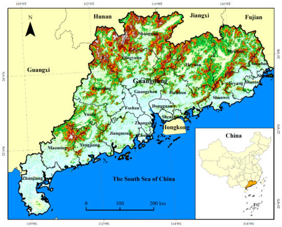
Figure 1.
Geographical location of Guangdong province, China.
Guangdong comprises 21 prefecture-level cities and is divided into four sub-regions, including nine cities in PRD, including Guangzhou, Foshan, Zhaoqing, Shenzhen, Dongguan, Huizhou, Zhuhai, Zhongshan, and Jiangmen, three cities in western Guangdong (WG), including Zhanjiang, Maoming, and Yangjiang, four cities in eastern Guangdong (EG), including Shantou, Jieyang, Chaozhou and Shanwei, and five cities in northern Guangdong (NG), including Shaoguan, Qingyuan, Yunfu, Meizhou, and Heyuan. In 2020, the urbanization rate of Guangdong reached 74.15%, exhibiting the highest urbanization rate except for Beijing, Tianjin, and Hebei [25]. Among the sub-regions, the population of PRD is the largest, reaching 77.95 million, and the populations of EG, WG, and NG are 16.39, 15.76, and 15.92 million, respectively. The urbanization rate of Shenzhen, Foshan, Dongguan, Zhuhai, Zhongshan, and Guangzhou exceeds 85%. Notably, the urbanization rate of Shenzhen has reached 99.54%, thereby representing the city with the highest urbanization rate in China [24]. In 2020, the GDP of the Guangdong Province was 11,076.094 billion yuan, ranking first in China. Specifically, the GDPs of Shenzhen, Guangzhou, and Foshan were more than 100 billion Yuan, respectively, and that of other cities ranged from 10 to 100 billion Yuan [24].
2.2. Data Sources
The used the following data sources were employed:
(1) Land use data. The land use data were obtained from the Resource and Environmental Science and Data Center, Chinese Academy of Science (http://www.resdc.cn/, accessed on 1 February 2022), with a time resolution of 10 years and a 1000-m spatial resolution, including five years of data in 1980, 1990, 2000, 2010, and 2020. The dataset is based on Landsat TM/ETM+ remote sensing image data, compliments of Liu’s and other Chinese land use remote sensing cartographic classification systems, and was generated by the human-computer interactive interpretation of land use change remote sensing information [56,57]. Each phase of data was subject to a unified quality inspection. Ten percent of the counties were randomly selected nationwide, and the data classification results were verified through field investigation. The classification and total accuracies were evaluated using a confusion matrix. The land use types were divided into six first-class types and 25 second-class types. Among them, the comprehensive evaluation accuracy of the first-class types of land use was more than 93%, and the comprehensive classification accuracy of the second-class types was more than 91% [57,58]. According to the data requirements herein, the land use types were reclassified into ten categories: paddy field, dry land, forest land, orchard, grassland, water and wetland, urban land, rural settlement, other construction land, and idle land.
2.3. Study Design
Herein, we analyzed the land use change and its effects on habitat quality from 1980 to 2020 in Guangdong Provence, China. First, we analyzed the long-time spatiotemporal dynamic changes of land use using the atlas analysis method. Then, we assessed the habitat quality in the corresponding year of land use using the Habitat Quality module (HQM) in the InVEST model and clarified the habitat change and its degradation using the hotspots analysis method (Getis-Ord G*index). Finally, we established IDI to represent the impact of annual land use change per unit area on HQC and CI to denote the total contribution of each land use type change on the HQC. Figure 2 shows the study design.
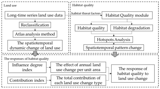
Figure 2.
Illustration of the research design.
2.4. Methods
2.4.1. Atlas Analysis Method
The land use data used herein are raster data. Each land use type has a corresponding unique code (paddy field, dry land, forest land, orchard, grassland, water and wetland, urban land, rural settlement, other construction land, and idle land are sequentially numbered from 1 to 10). Thus, an atlas analysis method was used to calculate the land use change; the specific formula is as follows:
where A is the land use type code before converting, and B is the land use type code after converting. M is the code of the land use change type. A = B denotes that the land use type does not change; A ≠ B denotes that land use type has changed.
The area of land use change is calculated in the formulas as follows:
where Ai is the area of land use change type i, with unit m2, and Ci is the total count of land use change type i, i.e., the raster count of M corresponding to the land use change type i.
2.4.2. Habitat Quality Assessment Model
The HQM in the InVEST model is selected to evaluate habitat quality. The module suggests that the habitat quality depends on a habitat’s proximity to human land uses and the intensity of these land uses. Habitat quality degrades with increasing intensity of nearby land use. Thus, the more frequent the human activity, the higher the intensity of land use and the worse the habitat quality [59,60]. This module, which produces a habitat quality map by combining the information of land use data and habitat threat factors, allows the rapid assessment of the status of and change in a proxy for more detailed measures of the biodiversity status.
The assessment principle of the HQM is as follows: First, habitat degradation is calculated depending on the sensitivity of different land types to threat factors and the intensity of external threats. The specific calculation formula is as follows:
where Dxj is the habitat degradation of the land use type j in a grid cell x ranging from 0 to 1. The larger the Dxj value, the higher the habitat degradation degree. ωr represents the weight of each threat factor (ranging from 0 to 1); ry denotes the effect of threat r that originates in grid cell y, essentially representing the intensity of threat factors. Additionally, irxy represents the distance between the habitat and the threat source and the impact of the threat across the space; βx is the factor that may mitigate the impact of threats on the habitat through various protection policies; Sjr indicates the sensitivity of the land type j to the threat factor r, where values closer to 1 indicate greater sensitivity; r is the habitat threat factor; y indicates all grid cells on the raster map of r; dxy is the distance between grid cell x and y; drmax is the influence range of the threat factors.
Then, the habitat quality based on the above-calculated habitat degradation and the suitability of different habitat types to the threat factors can be calculated as follows:
where Qxj is the habitat quality of the grid x in the land use type j, which ranges between 0 and 1, the higher the value, the higher the habitat quality; Hj denotes the habitat suitability of the grid x in the land use type j, whose range is [0, 1] and k is the half-saturation constant.
According to the principle of the HQM: paddy fields, dry land, orchard, urban land, rural settlement, other construction land, and idle land are considered threat factors. The data involved in the model mainly include the maximum threat distance, weight and decay of threat factors, habitat suitability, and the sensitivity of different habitat types to threat factors. The above parameter data mainly refer to the model reference values in the InVEST User’s Guide and the research results of relevant scholars in similar areas [35,46,53,61,62] (Table 1 and Table 2).

Table 1.
Threat factor property sheet.
Table 2.
Habitat score of each land use type.
2.4.3. Hotspots Analysis
The hotspots analysis method was used to illustrate the spatial clustering distribution characteristics of the HQC. The Getis–Ord G* index was employed to identify statistically significant spatial clusters of high values (hotspots) and low values (cold spots) of HQC:
where Gi* is the G* value of pixel i in the HQC raster data, and xj is the HQC value. Additionally, wij is the spatial weight matrix of pixel i and pixel j defined by the distance rules. If i and j are adjacent, their spatial weight is 1; otherwise is 0. x denotes the average HQC value; S is the standard deviation of the HQC value, and n is the total count of the pixel. The G* values are calculated using the ArcGIS 10.5 platform. When the G* value was significantly positive, the HQC exhibited a high-value concentration, indicating a hotspot area. In contrast, when the G* value was significantly negative, the HQC exhibited a low-value aggregation, denoting a cold spot area. The significance level was used to identify the hotspots and cold spots, and the areas corresponding to the G* value greater than or equal to 90% of the significance level were regarded as the hotspots and the cold spots.
2.4.4. Assessment of the Contribution of Land Use Change to Habitat Quality
We tailored the CI proposed by Zhang et al. [46] and Wu et al. [63]: First, IDI was established to represent the HQC caused by the annual land use change per unit. To more accurately evaluate the impact of land use change on habitat quality, we divided 1980–2020 into four periods: 1980–1990, 1990–2000, 2000–2010, and 2010–2020. The HQC caused by the unit land use change in the study area from 1980 to 2020 is obtained by calculating the mean IDI of these four periods. The calculation formula is as follows:
where IDIi denotes the HQC caused by the annual land use change type i per unit area, ΔQij is the total HQC caused by land use change type i in period j, and SAij is the total area of land use change type i in period j. When IDIi > 0, the land use change type i positively impacts the HQC and improves habitat quality. The higher its value, the greater is its positive impact and the more the improvement on the habitat quality. When IDIi < 0, the land use change type i negatively impacts the habitat quality and reduces the habitat quality. The greater its absolute value, the greater its negative impact, and the more habitat quality is reduced. When IDIi = 0, the land use change type i has no impact on the habitat quality.
Then, using IDIs, we calculated the CI of each land use change type to determine the contribution of different land use change types to HQC. The specific calculation formula is as follows:
where CIi is the contribution of the land use change type i on the habitat quality from 1980 to 2020, and PAi is the percentage of land use change type i in the total area of the land use change from 1980 to 2020. When CIi > 0, the land use change type i positively impacts the habitat quality, plays a positive role on HQC, and improves the habitat quality of the region. The larger its value, the more the habitat quality is improved. When CIi < 0, the land use change type i negatively impacts the habitat quality; the greater its absolute value is, the more the habitat quality is reduced. When CIi = 0, the contribution of the land use change type i to HQC is 0.
3. Results
3.1. Land Use Change in Guangdong
Between 1980 and 2020, the main land use types were cultivated land (dry land and paddy field) and woodland (forest land and orchard) (Figure 3). Specifically, the woodland area and cultivated land annually accounted for more than 55% and 22%, respectively. Spatially, woodland was mainly distributed in the hills and mountains in WG, EG, and NG, while cultivated land was concentrated in the plain areas along PRD and was scattered in other sub-regions.
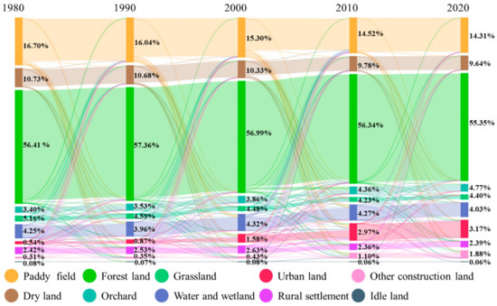
Figure 3.
Dynamic change of land use in Guangdong from 1980 to 2020. (Note: The percentage in the figure indicates area proportion of each land use type).
Over the past 40 years, the area of each land use type has greatly varied with time (Figure 3). Orchards, urban land, and other construction land showed a continuous growth trend, with the area increasing by 2423, 4652, and 2779 km2, respectively, achieving corresponding growth rates of 40.36%, 491.24%, and 506.19%, Urban land exhibited the largest area increment. The areas of the remaining land use types decreased to varying degrees. The largest reduction observed was in paddy fields, with a decrease of 4211 km2 (14.27%); followed by dry land, forest land, and grassland, with decreases of 1932 km2 (10.19%), 1884 km2 (1.89%), and 1358 km2 (14.88%), respectively. The water and wetland, rural settlement, and idle land areas exhibited relatively small decreases of 391 km2 (5.20%), 53 km2 (1.24%), and 25 km2 (18.52%), respectively. Furthermore, the change of most land use types after 2000 (later stage) was greater than that before 2000 (early stage), and the land use change was more active in the later stage.
From 1980 to 2020, the spatiotemporal conversion of the land use in the study area exhibited the following characteristics (Figure 3 and Figure 4):
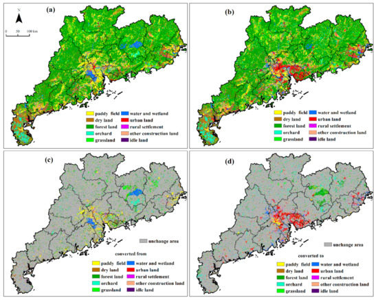
Figure 4.
Land use spatial distribution in 1980 (a) and 2020 (b) and land use converted in (c) and out (d) from 1980 to 2020.
(1) Large-scale construction land in the PRD continued to expand. This expansion was mainly reflected in the conversion of a large area of paddy fields, dry land, and forest land into urban land and other construction land. Specifically, 2075 and 964 km2 of paddy fields were converted to urban land and other construction land, respectively, of which 1340 km2 was mainly distributed and concentrated in the plain area of PRD. Additionally, 863 km2 and 472 km2 of dry land have been converted to urban land and other construction land, respectively; the former was concentrated in the PRD (670 km2), while the latter was scattered throughout the whole region. Furthermore, 556 km2 and 873 km2 of forest lands were converted to urban land and other construction land, respectively, which was mainly distributed in the plain area of PRD (501 km2 and 2446 km2). Moreover, the rural settlement area exhibited a net decrease, mainly due to the imbalance between the 1121 km2 of land converted into rural settlements and the 1174 km2 that was converted out, among which 487 km2 was converted to urban land, which was mainly distributed in the plain area of PRD.
(2) Large-scale changes in woodland occurred in NG. These changes are mainly manifested in the mutual conversion of forest land and orchard in hills and mountainous areas where 3511 km2 of forest land was converted into orchards, of which 2054 km2 is distributed in NG. In contrast, 1429 km2 of orchard land was converted to forest land, of which 895 km2 is distributed in NG. Additionally, large areas of conversion into and out of forest land and other land occurred. For example, 1040 km2 of paddy field and 901 km2 of dry land were converted into forest land; the former is mainly distributed in NG (589 km2), while the latter was mainly distributed in WG; 980 km2 of water and wetland area was converted into forest land, among which, 861 km2 is distributed in NG. In addition, 964, 899, and 771 km2 of forest lands were converted to paddy fields, grassland, and dry land, respectively, which is mainly distributed in NG (563, 527, and 264 km2).
(3) The mutual conversion of paddy fields to and from water and wetland occurred along rivers and coastal areas. Among them, 1409 km2 of paddy field was converted to water and wetland, including 1007 km2 distributed in the PRD, which is along the banks of the Xijiang River, Dongjiang River, and Beijiang River, and the coastal areas of Jiangmen and Zhuhai. Additionally, 210 and 102 km2 are distributed in the coastal areas of EG and WG. Moreover, 594 km2 of water and wetland was converted to paddy fields, of which 470 km2 is distributed along the Xijiang River and Beijiang River.
3.2. Habitat Quality and Degradation
3.2.1. Variation in Habitat Quality
From 1980 to 2020, the annual average habitat quality of Guangdong was above 0.6 (Figure 4). Spatially, the habitat quality was between 0 and 1. The distribution pattern exhibited a low habitat quality in plain areas and high habitat quality in the hilly and mountainous areas. Higher habitat quality was observed in the Pearl River Estuary and inland areas. Habitat quality was divided into five levels according to its value: level-1 (0–0.2), level-2 (0.2–0.4), level-3 (0.4–0.6), level-4 (0.6–0.8) and level-5 (0.8–1). The habitat quality of the study area is mainly level-5 (the area for each year accounts for more than 55%), level-1 (the area for each year accounts for more than 14%), and level-2 (the area for each year accounts for more than 15%).
The habitat quality of the four sub-regions in the study area (Figure 5) shows that the annual average habitat quality in NG is the highest, above 0.7 in each year, and the habitat quality in WG is the lowest, below 0.6 in each year. Additionally, the annual average habitat quality in EG and PRD ranges between 0.6 and 0.7 in each year. Spatially, the habitat quality of the four regions is mostly exhibits three levels: level-1, level-2, and level-5 (Figure 6). Over the past 40 years, the habitat quality in the Guangdong Province has gradually decreased with time. The annual average habitat quality decreased by 0.0351, which is equivalent to a reduction rate of 4.83%. The habitat quality of all sub-regions decreased to varying degrees. Among them, the annual average habitat quality decreased the most in PRD, which was –0.0549 (7.88%), and decreased by 0.0287 (3.46%), 0.0276 (4.34%), and 0.0205 (3.57%) in NG, EG, and WG, respectively.
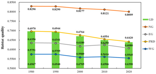
Figure 5.
Annual average habitat quality of Guangdong and its sub-regions from 1980 to 2020. (Note: GD refers to Guangdong; NG refers to northern Guangdong; EG refers to eastern Guangdong; PRD refers to Pearl River Delta; WG refers to western Guangdong (WG)).
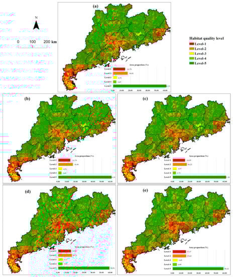
Figure 6.
Spatial distribution of habitat quality levels in Guangdong: 1980 (a); 1990 (b); 2000 (c); 2010 (d); 2020 (e).
Spatially (Figure 7), from 1980 to 2020, the habitat quality of 80.33% of the regions in the Guangdong Province decreased to varying degrees, with a reduction amount between 0 and 1, of which 70.99% of the regions decreased between 0 and 0.1, 4.53% of the regions decreased between 0.1 and 0.2, and 1.85%, 2.24% and 1.03% of the regions decreased between 0.4 and 0.5, 0.5 and 0.6, and 0.6 and 0.7, respectively. High of reduction values were mainly distributed in southern Guangzhou, the eastern Foshan, Dongguan, and Shenzhen with a flat terrain around the plain area of PRD, as well as Heyuan and Meizhou in NG. High reduction values were also sporadically distributed in other areas, while low reduction values were distributed throughout the entire region. The habitat quality in 16.39% of the regions increased to varying degrees, with the increment ranging from 0 to 1, of which 12.33% of the regions increased between 0 and 0.1, 1.07% of the regions increment between 0.4 and 0.5. The area for the other increments was small. High and low values of the incremental increases are sporadically distributed in the whole region. Finally, the habitat quality in 3.28% of the regions did not change, mainly in the areas with unchanged land use.
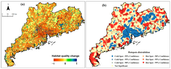
Figure 7.
The habitat quality change (a) and its hotspots distribution (b) from 1980 to 2020. (Note: 99% Confidence refers to at the 99% significant level; 95% Confidence refers to at the 95% significant level; 90% Confidence refers to at the 90% significant level).
3.2.2. Habitat Degradation
The annual average habitat degradation in the Guangdong Province was more than 0.02 (Figure 8). Specifically, the habitat degradation in WG was the highest, with a value of more than 0.025 per year, while that in NG was the lowest, with a value of less than 0.02 per year. The habitat degradation in PRD was generally between 0.02–0.025. Spatially, the habitat degradation is between 0 and 1. High-value areas were mainly distributed in the low altitude and flat terrain in the PRD, WG, and EG. In contrast, low-value areas were mainly distributed in areas with relatively high altitudes and large slopes (Figure 9).
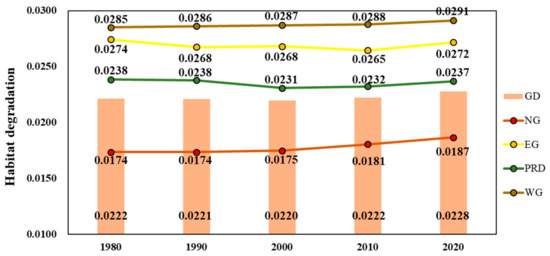
Figure 8.
Annual average habitat degradation of Guangdong and its sub-regions from 1980 to 2020. (Note: GD refers to Guangdong; NG refers to northern Guangdong; EG refers to eastern Guangdong; PRD refers to Pearl River Delta; WG refers to western Guangdong).
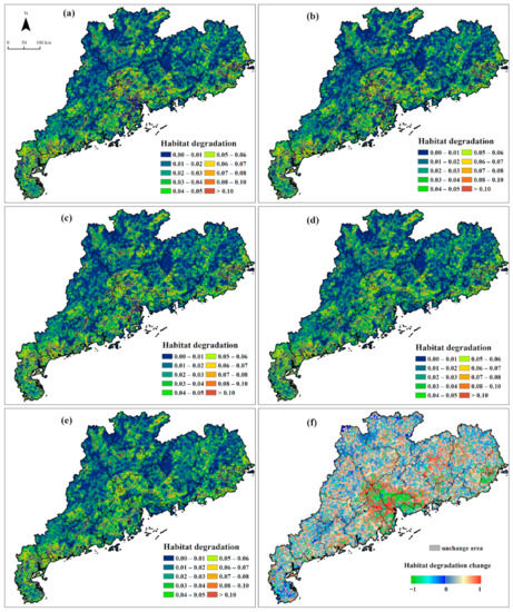
Figure 9.
Spatial distribution of habitat degradation in 1980 (a), 1990 (b), 2000 (c), 2010 (d), 2020 (e) and habitat degradation change from 1980 to 2020 (f).
From 1980 to 2020, the annual average habitat degradation of the Guangdong Province first decreased and then increased (Figure 8). The overall change exhibited a “concave” curve. The curve rebounded after reaching the lowest value in 2000. The habitat degradation decreased in the early stage and continued to increase in the later stage. The annual average habitat degradation increased by 0.0006 (2.79%). The habitat degradation of EG and the PRD decreased by 0.0003 (0.94%) and 0.0001 (0.57%), respectively, while that of NG and WG increased by 0.0013 (7.58%) and 0.0006 (2.19%), respectively.
Spatially, from 1980 to 2020, habitat degradation in 33.75% of the regions decreased (Figure 9f). The reduced high-value areas were mainly distributed in PRD, and the low-value areas were scattered throughout the entire region; the habitat degradation in 66.21% of the regions exhibited an increasing trend. The high-value areas are mainly distributed along the periphery of the plain area of PRD, and Heyuan and Meizhou in NG, and were scattered in other areas. Low-value areas were scattered throughout the entire region. Furthermore, habitat degradation remained unchanged in 0.04% of the regions.
3.3. The Impact of Land Use Change on Habitat Quality
3.3.1. IDIs of Different Land Use Change Types
The depiction of the average habitat quality of different land use types in the selected year (Figure 10), shows that the annual average habitat qualities of forest land, grassland, water and wetland were larger, all above 0.8; while those of paddy field, orchard, idle land, and other construction land is between 0.2 and 0.6, and those of dry land, urban land, and rural settlement were the smallest, all below 0.2. From 1980 to 2020, the annual average habitat quality for each land use type has decreased to varying degrees. The largest reduction was observed for water and wetland, with a decrease of 0.0519 and a decrease rate of 5.99%, followed by forest land, grassland, and idle land, with decreases of 0.0186 (1.94%), 0.0296 (3.20%) and 0.0186 (3.39%), respectively. The HQC for other land use types was relatively small, no more than 0.01.
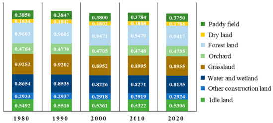
Figure 10.
Annual average habitat quality of different land use types from 1980 to 2020. (Note: the annual average habitat quality of urban land and rural settlement is 0).
Land use change has both positive and negative impacts on habitat quality. Table 3 shows that the conversion of forest land, grassland, and water and wetland to dry land, urban land, rural settlement, and other construction land negatively impact habitat quality. The conversion of forest land to urban land afforded the most negative impact, with an IDI value of −0.0903, followed by the conversion of grassland to urban land, with an IDI value of −0.0858. The IDIs of other types were also below −0.05. Furthermore, the conversion of forest land to dry land and idle land to rural settlement negatively affected the habitat quality, with IDIs of less than −0.05.
Table 3.
The IDIs of different land use change types.
The conversions of dry land, urban land, rural settlement, and other construction land to forest land, grassland, and water and wetland positively impacted the habitat quality, with IDIs all above 0.05. The conversion of urban land to forest land, grassland, water and wetland afforded the greatest positive impact, with IDIs values of above 0.09. Additionally, the conversions of paddy fields to forest land, and rural settlement to idle land have great positive impacts on habitat quality, with IDIs of above 0.05. The absolute value of IDI for other land use change types was below 0.05, which exerts a relatively small positive or negative impact on the habitat quality.
3.3.2. CIs of Different Land Use Change Types
From the perspective of CIs (Table 4), the contribution of land use change to habitat quality is mainly negative. The total CI is −100.24, where −56.20 is attributed to the conversion of forest land to other land use types, and −32.49 is caused by the conversion of the other land use types (except for forest land) to construction land. Specifically, the CI of the conversion of forest land to orchards is the most negative, with a CI value of −24.09, accounting for 24.03% of the total negative CI, followed by the conversion of paddy fields to urban land, and forest land to dry land, with CI values (percentage of total negative CI) of −11.67 (11.64%) and −8.04 (8.02%), respectively. Additionally, the negative contributions associated with the conversion of forest land to paddy fields, forest land to dry land, and water and wetland to urban land are large, and their respective CIs are less than −1.
Table 4.
The CIs of land use change to habitat quality from 1980 to 2020.
The positive contribution of land use change to the habitat quality constitutes less than half of the negative contribution, which is 48.24. Of this, 27.91 stems from the conversion of other land types to forest land. The CI of converting orchard to forest land is the largest, with a value of 9.53, followed by the conversions from paddy field to forest land, dry land to forest land, and paddy field to water and wetland, with CIs of 7.79, 8.98, and 8.31, respectively, The CI values of other land use change types do not exceed 1.
The CIs in each sub-region of the study area significantly differ. Table 5 shows that positive contribution mainly occurs in NG and PRD. The contribution in these two sub-regions accounts for more than 70% of the total positive contribution, while the positive contribution in EG and WG is relatively small. Moreover, the CI value associated with the conversion from orchard to forest land is the largest in NG, the conversion from paddy field to water and wetland is the largest in EG and PRD, and that from dry land to forest land is the largest in WG.
Table 5.
The CIs in four sub-regions of Guangdong from 1980 to 2020.
The negative contribution mainly occurs in NG and PRD, accounting for 32.6% and 49.15% of the total negative contribution, respectively. The negative contribution is relatively small in EG and WG. The land use change types causing habitat quality reduction in each sub-region are different. For example, the habitat quality reduction in NG is mainly caused by the conversion of forest land to other land use types (with CI value of −24.27), among which the CI value of forest land to orchard is −14.03. The degradation of the habitat quality in EG is mainly caused by the conversion of paddy fields to construction land, and the conversion of forest land into other land use types. The CI values of the conversion of paddy fields to urban land and forest land to orchards are the smallest, which are −1.30 and −1.25, respectively. The habitat quality reduction in PRD is mainly due to the conversion of other land use types to construction land, among which the CI value of paddy field to urban land is the smallest. The habitat quality reduction in WG mainly occurs due to the conversion of forest land into other land use types, among which the CI value of forest land to dry land is the smallest.
4. Discussion
4.1. The Verification of Habitat Quality
The habitat quality value assessed herein is considered a continuous variable in HQM. It is a dimensionless comprehensive indicator with a range of 0–1. The assessment values of the habitat quality are not field observations, and the accuracy of the assessment results cannot be verified by direct comparison with the actual observation values. Moreover, field observations are used in the evaluation index systems to assess the habitat quality, and systems that are too subjective will afford large differences in results and are therefore less suitable for validating of the habitat quality assessed by HQM. Therefore, we cross-validated our assessment results by comparing with the HQM-assessed results of other scholars in the whole and part of the study area (Table 6).
Table 6.
The assessment results of habitat quality within Guangdong Province of other scholars.
The comparison results show that differences are present in the respective habitat quality assessment values in the same areas, but the overall differences are not significant, none of them exceeded ±0.1 compared with our study results. Additionally, the trends of change over time are consistent. Therefore, it is reasonable to assume that the HQM is applicable to the habitat quality assessment in the study area and that our assessment results can effectively describe the status and changes in habitat quality in the study area.
The differences in the habitat quality assessment results mainly stem from the selection of threat factors and the parameters settings. The threat factors selection and the parameter settings, most of them refer to the InVEST User’s Guide and other scholars, and the parameters and threat factors for the same study area exhibit little difference.
4.2. Degradation of the Habitat Quality and the Policy Implications
Regarding the impact of land use change on habitat quality, land use change can either improve or reduce habitat quality. In most cases, the positive impact of mutual conversion between two land use types is less than the negative impact (Table 3), demonstrating that restoring the habitat quality to its original state is difficult. Land use types with high habitat quality (e.g., forest; grassland; and water and wetland) are mostly unspoiled natural ecosystems, which are complete and stable, and they have a certain ability to restore and maintain stability and are vulnerable to the negative impact of the land use change. In contrast, land use types with low habitat quality (e.g., orchard; cultivated land; and settlements) are mostly semi-natural and artificial ecosystems, which are greatly affected by human activities. The conversion from a high-quality to low-quality land use type is very destructive, and it directly changes the type, nature, and layout of ecosystems; a natural ecosystem gradually becomes a semi-natural and an artificial ecosystem. Even if water and soil conservation projects can promote the restoration of the ecosystem, man-made selective planting causes the simple structure of the forest land and grassland to directly affect the biodiversity, further demonstrating that the habitat quality cannot be restored to its original state.
The regional HQC is related to not only IDIs but also the area of land use change type. The three main land use change types that cause the decline of habitat quality are forest land to orchards, paddy fields to urban land, and forest land to dry land. Among them, the conversion of forest land to dry land affords the largest IDI and affords relatively large conversion areas. Therefore, this land use change type significantly negatively impacts the HQC. Notably, the IDIs of the conversion of forest land to orchard and paddy field to urban land are relatively small, but due to the large conversion area, the CIs of these two land use change types are very large. Therefore, two approaches are introduced to better restore the ecosystem and improve the habitat quality. First, for land use types with high habitat quality, the conversion to the known land use types with low habitat quality should be slowed. For different land use types, measures to improve habitat quality should be targeted. For example, for economic forests and water conservation forests, not only their water and soil conservation and economic benefits but also the diversity of species should be considered. Second, the habitat quality of land use types with low habitat quality is easy to improve. Measures such as employing reasonable farming methods of cultivated land and increasing the internal green areas within an urban land will improve the habitat quality.
4.3. The Merits and Limitations of This Study
This study quantitatively evaluates the response of habitat quality to land use change in Guangdong Province over the past 40 years. Moreover, it analyzes the main land use change types causing HQC and briefly analyzes the relation between land use and habitat quality. The study results can serve as a reference for land use planning, ecosystem restoration, and biodiversity protection in the Guangdong Province. The limitations of this study are as follows. First, the regional scale research can only explain the relationship between land use change and habitat quality change in the province. Although the research results provide reference value, more specific response measures need to be carefully studied from a finer scale. Second, the InVEST model itself has limitations. The model evaluation only considers the direct relationship between natural factors and habitat quality, while human factors, a known important factor affecting the regional habitat quality, do not directly participate in the evaluation of the habitat quality.
5. Conclusions
Using the land use data from 1980 to 2020 and the InVEST model, we analyzed the temporal and spatial evolution characteristics of land use in the Guangdong Province, evaluated the regional habitat quality, and revealed its temporal and spatial change characteristics. We established CI to reveal the response of habitat quality to land use change. The results from 1980 to 2020 reveal the following. (1) The land use change in Guangdong Province exhibited obvious temporal and spatial evolution characteristics, including large-scale expansion of the construction land in plain areas, large-scale conversion into and out of forest land in hilly and mountainous areas, and the mutual conversion of paddy field and water and wetland in coastal and river areas; (2) The habitat quality of the Guangdong Province presented a spatial distribution pattern of low quality in plain areas and high quality in hilly and mountainous areas. The habitat quality gradually decreased with time, and the decrease was larger in the later stage compared to the early stage, which decreased by 0.0351, with a reduction rate of 4.83%; (3) The negative contribution of land use change to HQC is about twice the positive contribution. The decline of the habitat quality in Guangdong Province is mainly due to the conversion of forest land to orchards, paddy fields to urban land and forest land to dry land, with CIs of −24.09, −11.67, and −8.04, respectively. Analyzing the CIs and the relationship between land use and habitat quality, this study presented targeted habitat quality restoration measures, providing a scientific reference for land use management and habitat protection in the study area.
Author Contributions
Conceptualization, H.Z. and Y.L.; methodology, H.Z. and Y.L.; software, H.Z.; validation, H.Z.; formal analysis, H.Z.; resources, Y.L.; data curation, Y.L.; writing—original draft preparation, Y.L.; writing—review and editing, Y.L.; supervision, Y.L.; project administration, Y.L.; funding acquisition, Y.L. All authors have read and agreed to the published version of the manuscript.
Funding
This research was funded by the National Natural Science Foundation of China (42071204) and the Guangdong Basic and Applied Basic Research Foundation (2019A1515011661).
Institutional Review Board Statement
Not applicable.
Informed Consent Statement
Not applicable.
Data Availability Statement
The data used to support the findings of this study are available from the corresponding author upon request.
Conflicts of Interest
The authors declare no conflict of interest.
References
- Krausman, P.R. Some basic principles of habitat use. Ida. For. Wildl. Range Exp. Stn. Bull. 1999, 70, 85–90. [Google Scholar]
- Kija, H.K.; Ogutu, J.O.; Mangewa, L.J.; Bukombe, J.; Verones, F.; Graae, B.J.; Kideghesho, J.R.; Said, M.Y.; Nzunda, E.F. Spatio-Temporal Changes in Wildlife Habitat Quality in the Greater Serengeti Ecosystem. Sustainability 2020, 12, 2440. [Google Scholar] [CrossRef]
- Zhang, H.; Zhang, C.; Hu, T.; Zhang, M.; Ren, X.; Hou, L. Exploration of roadway factors and habitat quality using InVEST. Transp. Res. Part D Transp. Environ. 2020, 87, 102551. [Google Scholar] [CrossRef]
- Kunwar, R.M.; Evans, A.; Mainali, J.; Ansari, A.S.; Rimal, B.; Bussmann, R.W. Change in forest and vegetation cover influencing distribution and uses of plants in the Kailash Sacred Landscape, Nepal. Environ. Dev. Sustain. 2020, 22, 1397–1412. [Google Scholar] [CrossRef]
- Ahmadi Mirghaed, F.; Souri, B. Relationships between habitat quality and ecological properties across Ziarat Basin in northern Iran. Environ. Dev. Sustain. 2021, 23, 16192–16207. [Google Scholar] [CrossRef]
- Bai, L.; Xiu, C.; Feng, X.; Liu, D. Influence of urbanization on regional habitat quality: A case study of Changchun City. Habitat Int. 2019, 93, 102042. [Google Scholar] [CrossRef]
- Lee, D.-J.; Jeon, S.W. Estimating Changes in Habitat Quality through Land-Use Predictions: Case Study of Roe Deer (Capreolus pygargus tianschanicus) in Jeju Island. Sustainability 2020, 12, 10123. [Google Scholar] [CrossRef]
- Rybicki, J.; Hanski, I. Speciesarea relationships and extinctions caused by habitat loss and fragmentation. Ecol. Lett. 2013, 16, 27–38. [Google Scholar] [CrossRef]
- Song, C.; Lee, W.-K.; Lim, C.-H.; Jeon, S.W.; Kim, J. Habitat Quality Valuation Using InVEST Model in Jeju Island. J. Korea Soc. Environ. Restor. Technol. 2015, 18, 1–11. [Google Scholar] [CrossRef]
- Janus, J.; Bozek, P. Land abandonment in Poland after the collapse of socialism: Over a quarter of a century of increasing tree cover on agricultural land. Ecol. Eng. 2019, 138, 106–117. [Google Scholar] [CrossRef]
- Sharma, R.; Nehren, U.; Rahman, S.; Meyer, M.; Rimal, B.; Aria Seta, G.; Baral, H. Modeling Land Use and Land Cover Changes and Their Effects on Biodiversity in Central Kalimantan, Indonesia. Land 2018, 7, 57. [Google Scholar] [CrossRef]
- Gao, Y.; Ma, L.; Liu, J.; Zhuang, Z.; Huang, Q.; Li, M. Constructing Ecological Networks Based on Habitat Quality Assessment: A Case Study of Changzhou, China. Sci. Rep. 2017, 7, 46073. [Google Scholar] [CrossRef] [PubMed]
- Guo, Z.W.; Zhang, L.; Li, Y.M. Increased Dependence of Humans on Ecosystem Services and Biodiversity. PLoS ONE 2010, 5, e13113. [Google Scholar] [CrossRef] [PubMed]
- Liu, Y.; Huang, X.J.; Yang, H.; Zhong, T.Y. Environmental effects of land-use/cover change caused by urbanization and policies in Southwest China Karst area A case study of Guiyang. Habitat Int. 2014, 44, 339–348. [Google Scholar] [CrossRef]
- Ding, Q.; Chen, Y.; Bu, L.; Ye, Y. Multi-Scenario Analysis of Habitat Quality in the Yellow River Delta by Coupling FLUS with InVEST Model. Int. J. Environ. Res. Public Health 2021, 18, 2389. [Google Scholar] [CrossRef]
- Newbold, T.; Hudson, L.N.; Hill, S.L.L.; Contu, S.; Lysenko, I.; Senior, R.A.; Boerger, L.; Bennett, D.J.; Choimes, A.; Collen, B.; et al. Global effects of land use on local terrestrial biodiversity. Nature 2015, 520, 45–50. [Google Scholar] [CrossRef]
- Ramaswami, A. Unpacking the Urban Infrastructure Nexus with Environment, Health, Livability, Well-Being, and Equity Comment. One Earth 2020, 2, 120–124. [Google Scholar] [CrossRef]
- Wang, H.; Tang, L.; Qiu, Q.; Chen, H. Assessing the Impacts of Urban Expansion on Habitat Quality by Combining the Concepts of Land Use, Landscape, and Habitat in Two Urban Agglomerations in China. Sustainability 2020, 12, 4346. [Google Scholar] [CrossRef]
- Du, Y.; Qin, W.; Sun, J.; Wang, X.; Gu, H. Spatial Pattern and Influencing Factors of Regional Ecological Civilisation Construction in China. Chin. Geogr. Sci. 2020, 30, 776–790. [Google Scholar] [CrossRef]
- Gai, M.; Wang, X.; Qi, C. Spatiotemporal Evolution and Influencing Factors of Ecological Civilization Construction in China. Complexity 2020, 2020, 8829144. [Google Scholar] [CrossRef]
- Ye, Y.; Li, S.; Zhang, H.; Su, Y.; Wu, Q.; Wang, C. Spatial-Temporal Dynamics of the Economic Efficiency of Construction Land in the Pearl River Delta Megalopolis from 1998 to 2012. Sustainability 2017, 10, 63. [Google Scholar] [CrossRef]
- Ye, Y.; Zhang, J.; Wang, T.; Bai, H.; Wang, X.; Zhao, W. Changes in Land-Use and Ecosystem Service Value in Guangdong Province, Southern China, from 1990 to 2018. Land 2021, 10, 426. [Google Scholar] [CrossRef]
- Li, C.; Kuang, Y.; Huang, N.; Zhang, C. The long-term relationship between population growth and vegetation cover: An empirical analysis based on the panel data of 21 cities in Guangdong Province, China. Int. J. Environ. Res. Public Health 2013, 10, 660–677. [Google Scholar] [CrossRef] [PubMed]
- National Bureau of Statistics of China. China Statistical Yearbook; China Statistics Press: Beijing, China, 2021. [Google Scholar]
- Statistics Bureau of Guangdong Province. Guangdong Statistical Yearbook; China Statistics Press: Beijing, China, 2021. [Google Scholar]
- Xu, F.; Wang, Z.; Chi, G.; Zhang, Z. The impacts of population and agglomeration development on land use intensity: New evidence behind urbanization in China. Land Use Policy 2020, 95, 104639. [Google Scholar] [CrossRef]
- Liu, J.; Ning, J.; Kuang, W.; Xu, X.; Zhang, S.; Yan, C.; Li, R.; Wu, S.; Hu, Y.; Du, G.; et al. Spatio-temporal patterns and characteristics of land-use change in China during 2010–2015. Acta Geogr. Sin. 2018, 28, 16. [Google Scholar]
- Seto, K.C.; Fragkias, M.; Gueneralp, B.; Reilly, M.K. A Meta-Analysis of Global Urban Land Expansion. PLoS ONE 2011, 6, e23777. [Google Scholar] [CrossRef] [PubMed]
- Song, M.; Wu, Y.; Chen, L. Does the land titling program promote rural housing land transfer in China? Evidence from household surveys in Hubei Province. Land Use Policy 2020, 97, 104701. [Google Scholar] [CrossRef]
- Lai, Y.; Huang, G.; Chen, S.; Lin, S.; Lin, W.; Lyu, J. Land Use Dynamics and Optimization from 2000 to 2020 in East Guangdong Province, China. Sustainability 2021, 13, 3473. [Google Scholar] [CrossRef]
- Ren, H.; Chen, H.; Li, L.; Li, P.; Hou, C.; Wan, H.; Zhang, Q.; Zhang, P. Spatial and temporal patterns of carbon storage from 1992 to 2002 in forest ecosystems in Guangdong, Southern China. Plant Soil 2013, 363, 123–138. [Google Scholar] [CrossRef]
- Department of Water Resources of Guangdong Province. Bulletin of Soil and Water Conservation of Guangdong Province; Department of Water Resources of Guangdong Province: Guangzhou, China, 2020. [Google Scholar]
- Fan, X.; Gu, X.; Yu, H.; Long, A.; Tiando, D.S.; Ou, S.; Li, J.; Rong, Y.; Tang, G.; Zheng, Y.; et al. The Spatial and Temporal Evolution and Drivers of Habitat Quality in the Hung River Valley. Land 2021, 10, 1369. [Google Scholar] [CrossRef]
- Huang, J.; Tang, Z.; Liu, D.; He, J. Ecological response to urban development in a changing socio-economic and climate context: Policy implications for balancing regional development and habitat conservation. Land Use Policy 2020, 97, 104772. [Google Scholar] [CrossRef]
- Wu, L.; Sun, C.; Fan, F. Estimating the Characteristic Spatiotemporal Variation in Habitat Quality Using the InVEST Model—A Case Study from Guangdong–Hong Kong–Macao Greater Bay Area. Remote Sens. 2021, 13, 1008. [Google Scholar] [CrossRef]
- Verheyen, H.K. Legacies of the past in the present-day forest biodiversity: A review of past land-use effects on forest plant species composition and diversity. Ecol. Res. 2007, 22, 361–371. [Google Scholar]
- Han, Y.; Kang, W.; Thorne, J.; Song, Y. Modeling the effects of landscape patterns of current forests on the habitat quality of historical remnants in a highly urbanized area. Urban For. Urban Green. 2019, 41, 354–363. [Google Scholar] [CrossRef]
- Mengist, W.; Soromessa, T.; Feyisa, G.L. Landscape change effects on habitat quality in a forest biosphere reserve: Implications for the conservation of native habitats. J. Clean. Prod. 2021, 329, 129778. [Google Scholar] [CrossRef]
- Sieber, A.; Uvarov, N.V.; Baskin, L.M.; Radeloff, V.C.; Bateman, B.L.; Pankov, A.B.; Kuemmerle, T. Post-Soviet land-use change effects on large mammals’ habitat in European Russia. Biol. Conserv. 2015, 191, 567–576. [Google Scholar] [CrossRef]
- Yang, J.; Li, S.; Lu, H. Quantitative Influence of Land-Use Changes and Urban Expansion Intensity on Landscape Pattern in Qingdao, China: Implications for Urban Sustainability. Sustainability 2019, 11, 6174. [Google Scholar] [CrossRef]
- Berta Aneseyee, A.; Noszczyk, T.; Soromessa, T.; Elias, E. The InVEST Habitat Quality Model Associated with Land Use/Cover Changes: A Qualitative Case Study of the Winike Watershed in the Omo-Gibe Basin, Southwest Ethiopia. Remote Sens. 2020, 12, 1103. [Google Scholar] [CrossRef]
- Song, S.; Liu, Z.; He, C.; Lu, W. Evaluating the effects of urban expansion on natural habitat quality by coupling localized shared socioeconomic pathways and the land use scenario dynamics-urban model. Ecol. Indic. 2020, 112, 106071. [Google Scholar] [CrossRef]
- Nie, C.; Yang, J.; Huang, C. Assessing the Habitat Quality of Aquatic Environments in Urban Beijing. Procedia Environ. Sci. 2016, 36, 162–168. [Google Scholar] [CrossRef]
- Santelmann, M.; Freemark, K.; Sifneos, J.; White, D. Assessing effects of alternative agricultural practices on wildlife habitat in Iowa, USA. Agric. Ecosyst. Environ. 2006, 113, 243–253. [Google Scholar] [CrossRef]
- Sallustio, L.; De Toni, A.; Strollo, A.; Di Febbraro, M.; Gissi, E.; Casella, L.; Geneletti, D.; Munafo, M.; Vizzarri, M.; Marchetti, M. Assessing habitat quality in relation to the spatial distribution of protected areas in Italy. J. Environ. Manag. 2017, 201, 129–137. [Google Scholar] [CrossRef] [PubMed]
- Zhang, X.; Song, W.; Lang, Y.; Feng, X.; Yuan, Q.; Wang, J. Land use changes in the coastal zone of China’s Hebei Province and the corresponding impacts on habitat quality. Land Use Policy 2020, 99, 104957. [Google Scholar] [CrossRef]
- He, J.; Huang, J.; Li, C. The evaluation for the impact of land use change on habitat quality: A joint contribution of cellular automata scenario simulation and habitat quality assessment model. Ecol. Model. 2017, 366, 58–67. [Google Scholar] [CrossRef]
- Li, F.; Wang, L.; Chen, Z.; Clarke, K.C.; Li, M.; Jiang, P. Extending the SLEUTH model to integrate habitat quality into urban growth simulation. J. Environ. Manag. 2018, 217, 486–498. [Google Scholar] [CrossRef] [PubMed]
- Tang, F.; Fu, M.; Wang, L.; Zhang, P. Land-use change in Changli County, China: Predicting its spatio-temporal evolution in habitat quality. Ecol. Indic. 2020, 117, 106719. [Google Scholar] [CrossRef]
- Moreira, M.; Fonseca, C.; Vergílio, M.; Calado, H.; Gil, A. Spatial assessment of habitat conservation status in a Macaronesian island based on the InVEST model: A case study of Pico Island (Azores, Portugal). Land Use Policy 2018, 78, 637–649. [Google Scholar] [CrossRef]
- De Simone, S.; Sigura, M.; Boscutti, F. Patterns of biodiversity and habitat sensitivity in agricultural landscapes. J. Environ. Plan. Manag. 2017, 60, 1173–1192. [Google Scholar] [CrossRef]
- Li, M.; Zhou, Y.; Xiao, P.; Tian, Y.; Huang, H.; Xiao, L. Evolution of Habitat Quality and Its Topographic Gradient Effect in Northwest Hubei Province from 2000 to 2020 Based on the InVEST Model. Land 2021, 10, 857. [Google Scholar] [CrossRef]
- Polasky, S.; Nelson, E.; Pennington, D.; Johnson, K.A. The Impact of Land-Use Change on Ecosystem Services, Biodiversity and Returns to Landowners: A Case Study in the State of Minnesota. Environ. Resour. Econ. 2011, 48, 219–242. [Google Scholar] [CrossRef]
- Shobairi, S.O.R.; Li, M. Dynamic Modelling of VFC from 2000 to 2010 Using NDVI and DMSP/OLS Time Series: A Study in Guangdong Province, China. J. Geogr. Inf. Syst. 2016, 08, 205–223. [Google Scholar] [CrossRef]
- Zheng, J.Y.; Yin, Y.H.; Li, B.Y. A new scheme for climate regionalization in China. Acta Geogr. Sin. 2010, 65, 3–12. [Google Scholar]
- Kuang, W.; Liu, J.; Dong, J.; Chi, W.; Zhang, C. The rapid and massive urban and industrial land expansions in China between 1990 and 2010: A CLUD-based analysis of their trajectories, patterns, and drivers. Landsc. Urban Plan. 2016, 145, 21–33. [Google Scholar] [CrossRef]
- Liu, J.; Liu, M.; Deng, X.; Zhuang, D.; Zhang, Z.; Luo, D. The land use and land cover change database and its relative studies in China. J. Geogr. Sci. 2002, 12, 275–282. [Google Scholar]
- Jia, N.; Liu, J.; Kuang, W.; Xu, X.; Jing, N. Spatiotemporal patterns and characteristics of land-use change in China during 2010–2015. J. Geogr. Sci. 2018, 28, 547–562. [Google Scholar]
- Tallis, H. Natural Capital: Theory and Practice of Mapping Ecosystem Services; Oxford University Press: Oxford, UK, 2011. [Google Scholar]
- Sharp, R.; Chaplin-Kramer, R.; Wood, S.; Guerry, A.; Douglass, J. InVEST User’s Guide; Stanford University: Stanford, CA, USA; University of Minnesota: Minneapolis, MN, USA; The Nature Conservancy: Arlington, VA, USA; World Wildlife Fund: Minneapolis, MN, USA, 2018. [Google Scholar]
- Zhang, H.B.; Wu, F.E.; Zhang, Y.N.; Han, S.; Liu, Y.Q. Spatial and temporal changes of habitat quality in Jiangsu Yancheng wetland national nature reserve—Rare birds of China. Appl. Ecol. Environ. Res. 2019, 17, 4807–4821. [Google Scholar] [CrossRef]
- Zhang, L.; Hu, N. Spatial Variation and Terrain Gradient Effect of Ecosystem Services in Heihe River Basin over the Past 20 Years. Sustainability 2021, 13, 11271. [Google Scholar] [CrossRef]
- Wu, J.; Li, X.; Luo, Y.; Zhang, D. Spatiotemporal Effects of Urban Sprawl on Habitat Quality in the Pearl River Delta from 1990 to 2018. Sci. Rep. 2021, 11, 13981. [Google Scholar] [CrossRef]
- Liu, H.; Lin, M.; Zhou, R.; Zhong, L. Spatial and temporal evolution of habitat quality in Guangdong-Hong Kong-Macao Greater Bay Area based on InVEST model. Ecol. Sci. 2021, 40, 82–91. (In Chinese) [Google Scholar]
- Jiang, W.; Wu, J. Spatio-temporal evolution of habitat quality in Guangdong-Hong Kong-Macao Greater Bay Area based on regional GDP and population spatial distribution. Acta Ecol. Sin. 2021, 41, 1747–1757. [Google Scholar]
- Chen, C.; Zhang, Q.; Yang, X.; Li, R.; Xin, C. Habitat Quality Assessment of Waterfowl Ecological Corridors in the Pearl River Delta Based on InVEST Model. For. Environ. Sci. 2021, 37, 25–30. (In Chinese) [Google Scholar]
- Lu, Y.; Li, T.; Gong, J. Attribution of habitat quality in different geomorphological types in Guangdong Province. Ecol. Sci. 2022, 41, 24–32. (In Chinese) [Google Scholar]


Publisher’s Note: MDPI stays neutral with regard to jurisdictional claims in published maps and institutional affiliations. |
© 2022 by the authors. Licensee MDPI, Basel, Switzerland. This article is an open access article distributed under the terms and conditions of the Creative Commons Attribution (CC BY) license (https://creativecommons.org/licenses/by/4.0/).