Abstract
Thirty years ago, Mongolia’s Gobi Desert was intact, roadless and had low traffic, and it was a refuge for many endangered and rare species. A large mining boom and significant livestock grazing are currently putting pressure on the desert. Mining products were transported by trucks on dirt (gravel) roads between 2000 and 2012. Emphasizing its importance in the Mongolian economy, a paved road was constructed in 2012 along the dirt road. Unfortunately, vegetation along the paved road was removed without restoration. In the desert, locals continue to use, create and extend dirt roads. The impact of these roads on the vegetation has yet to be studied. We estimated the spatial extent of the dirt-road corridors in three time intervals (the years 2010, 2015 and 2020) and evaluated the vegetation along both paved and dirt roads at three distances (100, 500, and 900 m) from the road. Within ten years, the length of paved roads and soil dirt roads nearly doubled, although the majority of them were developed and created between 2015 and 2020. A single track makes up around 42 percent of the soil road, whereas the remaining 58 percent are roads consisting of three to four tracks with an average width of 26.5 m. The vegetation along the paved road was lower in terms of species richness, canopy cover, and the basal gap between perennial plants and biomass, compared to the soil road. Although the effects of soil roads on the vegetation along the roads is less negative than the effects of the paved road, the corridors formed along the soil roads span a non-negligible area of pastureland in the region. The vegetation along the already-constructed paved road in the desert should be artificially reclaimed with the aim of expediting natural revegetation. Moreover, a “new legislation” is required to prevent continued degradation due to the ongoing creation and extension of soil road corridors by local populations in the desert.
1. Introduction
In this century, a large extent of road expansion is projected to meet increasing demands for transportation, energy and agriculture, primarily in developing countries [1]. Constructing roads is often a proxy for environmental degradation in arid ecosystems [2]. In contrast, in sparsely populated countries, for example, in Mongolia, not having paved roads causes more environmental degradation than building roads [3].
When there is a lack of paved roads in Mongolia’s rangelands, people create their own tracks. A created dirt track shortly becomes unusable and impractical for driving because of corrugations in the soil, and the formation of potholes, ruts, and washboards from repeated vehicle usage. This leads people to create a new dirt track nearby. Eventually, a corridor of quasi-parallel roads covering a large area of pastureland is created. For example, in some places in central Mongolia, these dirt-track corridors are 164 m wide on average, but the widest is 6200 m [3].
Over the last 30 years, vehicle ownership has increased immensely in Mongolia; 43,700 vehicles were tested for annual inspection in 1990, increasing to 723,200 by 2021 [4] (Figure 1). As of 1990, Mongolia only had 1250 km of paved roads [5] for its 1.566 million km2 land area. A high need for having paved roads emerged, and Mongolia has currently extended its paved road routes to 9055.1 km [4], connecting only the centers and cities of the 21 aimags. The paved roads are capable of meeting 16% of the country’s overall transportation demands [6]. Therefore, dirt-road corridors are still utilized, extended and created. The spatial extent of the dirt roads and their adjacent corridors, as well as their effects on the nearby vegetation, remains unknown.
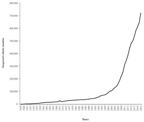
Figure 1.
The number of annually inspected vehicles between 1929 and 2021 in Mongolia. All registered vehicles are legally required to be inspected annually. Therefore, the number of annually inspected vehicles could represent the number of registered vehicles in Mongolia.
The southern part of Mongolia, the Gobi Desert, which constitutes about 30% of the total area of Mongolia, is experiencing a major change in land use as a consequence of an upsurge in coal, gold and copper mining activities, which account for about 40% of Mongolia’s GDP [7]. The livestock population quadrupled over the last 30 years. Until the present, the desert was used only by nomadic pastoralists since their first appearance in the ecosystem during the Late Holocene [8] and was one of the most intact ecosystems in the world and a refugee for many endangered and threatened plant and animal species [9,10,11]. Not only significant land (rangeland) degradation but also air pollution contamination, caused mainly by anthropogenic aerosols and frequent dust storms, have been reported in the desert [12,13]. This land degradation in the Gobi Desert is not only a problem for Mongolia; the desert is one of the largest emitters of airborne dusts reaching other parts of Asia on prevailing winds [14].
Due to the absence of railroads and paved roads, and as a result of the mining boom in the desert, many dirt roads were created between 2000 and 2011 to transport mining products to China. In 2012, Oyu Tolgoi, the largest mine in the desert, located in Khanbogd soum in Mongolia’s Umnugovi province, was connected to China’s border by a paved road (100 km long) that was built along the existing dirt-road corridor. Mongolia’s economy relied heavily on this road, making it an important political issue. Although the population of this region has grown considerably, only a limited number of roads have been paved since 2012. The absence of paved roads to other destinations leads to the creation of new dirt roads and the extension of old dirt-road corridors, resulting in rangeland degradation.
No attempts have been made to reveal the effects of dirt roads on the vegetation of desert ecosystems in Mongolia. Studies in other arid systems of the world have shown that the passage of vehicles removes vegetation and leads to a loss of surface soil and soil compaction [15,16]. The soil of the roads loses the ability to absorb and retain moisture and nutrients [17]. Plant communities adapt to the environment on the edges of the road, but the majority of them are invasive species that dominate the vegetation along roads [18]. Soil along the roads reduces the soil’s water-holding capacity, causing nutrient losses and erosion. The repeated passage of vehicles increases the levels of heavy metals, such as lead, zinc, cadmium, and nickel in road and roadside soil, and the intake of those heavy metals has a harmful impact on plants [19,20] Dirt roads generate a large amount of dust, which inhibits the key physiological activities of adjacent plants (respiration, evaporation, and photosynthesis), lowering the ecosystem’s primary production [21]. Dust falling on plants, for example, smothers the leaves and blocks stomata [22]. Furthermore, roads have numerous ecological consequences, not just on vegetation but also on animal habitats, slowing animal movement, isolating populations and communities, and causing mortality [23,24].
The construction of the new paved road in the desert in 2012 could release pressures on areas used for dirt-road corridors, but follow-up restoration and research on the corridors’ vegetation have not yet been conducted. It takes about 10 to 15 years for vegetation to recover its native state after the disturbance of vehicle passage [3]. Annuals predominate near recently abandoned roads, and permanent forbs and grasses eventually take their place. On the other hand, if proper restoration is not implemented after paving a road, the new construction could negatively impact the vegetation. According to the study of vegetation succession along newly paved roads in Yemen, road construction disturbed the vegetation along the road, and soil erosion often occurred shortly after construction [25]. Disturbance-sensitive and less-resistant plant species were found to go locally extinct as a response to road construction [26], and invasive species colonized the vegetation, and their cover was greater within 100 m of the highways in central California [27].
The effects of the paved road on nearby vegetation as well as the spatial extent of dirt-road corridors and their ecological impacts in the Gobi Desert remain unknown. Because the paved road was built over the previous dirt-road corridors, the vegetation along the road was impacted by a sequence of disturbances: (i) usage as a dirt road until 2010, (ii) paved road construction from 2010 to 2012, and (iii) the absence of reclamation following construction from 2012 onwards. Therefore, our research aimed (i) to quantify the spatial extent of the dirt-road corridors in the case of the research area, (ii) to describe the vegetation along the paved road and dirt-road corridors, and (iii) to characterize the natural recovery of vegetation along the paved road since the road’s construction in 2010.
Since 2000, the Oyu Tolgoi copper–gold mine has been under development in Mongolia’s South Gobi region. Mining has promised massive economic growth, minimal environmental impact, and the capacity to reconstruct the country and end the social and economic instability that Mongolia has faced for the past 30 years. Despite a 2014 contract between the Mongolian government and Oyu Tolgoi mining, the public remains wary of how mining is carried out and how it impacts the environment. The repercussions of mining on the country have given rise to a new neologism, “Mine-golia” [28]. Local herders primarily protested against the mining in its early stages, before 2015, due to dust from unpaved mining routes. Dust from unpaved roads creates distances and disconnections between people, livelihoods, and landscapes, amounting to a pasture enclosure, causing cattle diseases and threatening herders’ livelihoods in the region [13]. Protesters forced the construction of infrastructure, such as the paved road. The impact of mining product transportation on desert vegetation prior to the construction of the paved road was disregarded, while the paved road’s economic implications were applauded.
2. Methods
2.1. Study Area
In 2015, the research was carried out in Khanbogd soum, Umnugobi aimag (soum and aimag are the administrative units of Mongolia), where the biggest mine in Mongolia, Oyu Tolgoi, has been in operation since 2000 (Figure 2). Although the desert was the most sparsely populated area for humans and livestock prior to 1990, when Mongolia transitioned from a centrally planned economy to a free market, the number of livestock in Khanbogd soum has tripled since 1990, reaching 130,013 heads of livestock in 2015. This soum has also been the most appealing to migrants from other Mongolian provinces. In 1990, the population of the soum was 1929, and by 2015, it had risen to 5563, which is higher than the average population of Mongolia’s soums. In the last eight years (available open access data from nso.mn), the number of registered automobiles has increased from 837 to 3027.
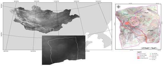
Figure 2.
The study area and plots along the dirt and paved roads, with three different distances from the roads.
The study area has a dry climate, with an average annual precipitation (MAP) of 80 mm, with 90 percent of that falling as rain during the warm season of July and August. The mean annual temperature is 8.3 °C. In comparison to an average year, the study year in 2015 was wet, with a total annual precipitation of 134.2 mm. The vegetation along the 100 km paved road connecting the Oyu Tolgoi mining site to the Gashuun Sukhait port on the Chinese border was studied (Figure 2). The road was constructed between 2010 and 2012. The dirt (soil) road chosen for our study is 45 km long between the center of Khanbogd soum and the Gaviluud bag (Figure 2).
The company Gashuun Suhait Road LLC has maintained the paved road since its construction. Permission to drive on the road has allowed to 19,016 trucks to transport mining products. Before the pandemic, on average, 4200 trucks were using the road in a week, which decreased to 300 during the COVID 19 pandemic.
2.2. Remote Sensing Data and Processing for the Estimation of Road Parameters
In order to quantify the spatial extent of the dirt road and the accompanying corridors for 2010, 2015 and 2020, sentinel-2 RGB (red–green–blue) composited scenes of the three years during August were obtained from the Copernicus Open Access Hub. The images were processed for estimating the (i) width of an individual dirt track, (ii) the number of tracks in a corridor and (iii) the total width of the dirt-road corridors. From the images, we classified dirt roads into two types, soil dirt roads and gravel dirt roads. Additionally, topographical maps were used with the raster data.
2.3. Vegetation Surveying
Ten plots were placed randomly alongside both types of roads to assess the vegetation. Each plot is divided into three subplots (50 × 50 m): 100 m, 300 m, and 900 m from the road. Five line transects (100 m) were systematically established at 0 m, 12.5 m, 25 m, 37.5 m, and 50 m of the line-point intercept (LPI) at each subplot. Every 1 m along each transect, the canopy cover and the basal gap between perennial plants were measured.
For the purpose of estimating species richness, all plants within a quadrat were recorded. All plants were cut at the ground level according to functional groups for plant biomass estimation. In addition, all plant litter was collected in a separate bag within the quadrat. Plant biomass samples were weighed after being dried in an oven at 60 °C for 48 h. Functional groupings (grass, forb, and shrub) and life forms (annual and perennial) were used to categorize canopy cover and plant biomass.
The species compositional dissimilarity of the plant communities at 100, 300, and 900 m from the two types of roads was assessed based on the Jaccard distance, which estimates the dissimilarity percentage of communities based on the number of their shared and non-shared species. The significance of the canopy cover, the basal gap between perennial plants and plant biomass between the road types and the distance from the road were tested by full factorial two-factor analyses of variances (ANOVA) [29].
3. Results
3.1. Spatial Extent of the Roads
Since 2010, Khanbogd soum’s paved road has been extended by 247.58 km; however, most of the new road was built between 2015 and 2020, reaching 384.20 km in 2020. The paved road covers an area of 307.37 ha (Table 1).

Table 1.
Spatial extent of roads within Khanbogd soum during 2010–2020.
Concurrent with the extension of the paved road, the length of the gravel road (covered by gravel) was reduced to 49.46 km by 2020, as the gravel road served as the primary track for the paved road’s construction. The state maintains the gravel road, which is an official part of the national road route. Prior to the construction of the paved road, the gravel road served as the principal road from the mining areas to the border. Although there should have been only one track for this road, several other tracks were built by drivers along the main track, resulting in the formation of a corridor. In 2010, the length of the gravel road was estimated to be 310.82 km based on satellite imagery. The biggest stretch of this road has eight tracks, with a corridor width of 83.35 m (Figure 3). On average, there were four tracks that were 43.37 m wide. This gravel road spans 1243.72 hectares (Table 1). The gravel road was abandoned following the construction of the paved road, and no effort has been made to restore the vegetation since its abandonment. Furthermore, it is unknown whether the vegetation along the abandoned gravel road is being naturally restored or is degrading further.
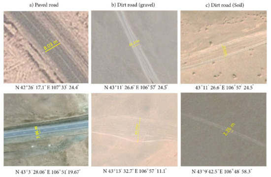
Figure 3.
Corridors and the total width of the road types at selected points. (a) The paved road; (b) gravel-road corridors; (c) soil-road corridors.
The other type of dirt road is the “soil” road, which is not legally registered as a national route. There is no administrative agency in charge of looking after or maintaining these roads. Within Khanbogd soum, as of 2010, we estimated 913.69 km of soil roads, mainly with single tracks (72% of the total soil road within the soum). By 2020, the soil road increased to 2243.91 km, covering 2241 ha (Table 1; Figure 4). About 42% of the soil road has a single track, while the remaining 58% is a corridor with an average width of 26.5 m and three to four tracks (Figure 3). The one-track dirt roads connect seasonal herder camps and see relatively little traffic. Other soil roads with corridors connect soum centers to nearby towns and mining camps.
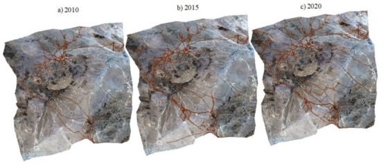
Figure 4.
Spatial extent of soil roads within Khanbogd soum for 2010–2020.
3.2. Vegetation along the Paved Road and Soil-Dirt Roads
Species Composition and Richness
A total of 29 plant species belonging to 25 genera in 15 families were recorded along the two types of roads (Table 1). The top three families, Amaranthaceae, Poaceae and Fabaceae, account for 15 species (52 percent). There are eight shrubs, four semi-shrubs, thirteen forbs, and two grass species.
Plant species richness decreased with the increase in distance intervals from 100 m to 300 and 900 m (15, 13, and 11 species, respectively) along the soil road, whereas there was no difference among the distances from the paved road (Figure 5). No difference in species richness (p = 0.09) was observed between the road types.
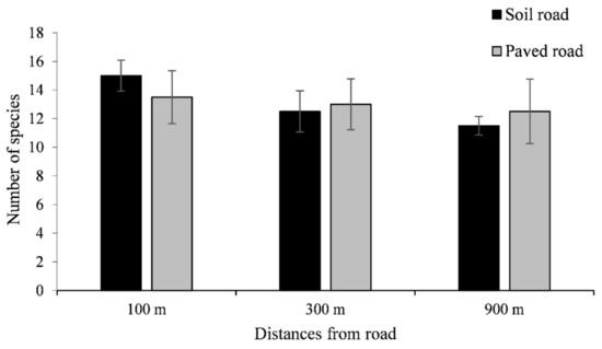
Figure 5.
Plant species richness at three distances from the paved and soil roads. Each bar represents mean ± 1 SE.
The species compositional dissimilarity of the plant communities at 100, 300, and 900 m from the two types of roads was assessed based on the Jaccard distance (Table 2), which estimates the dissimilarity percentage of communities based on the number of shared and non-shared species. The dissimilarity distance was 10 for plant communities at 100 and 300 m from the paved road, and 30 for 300 m and 900 m. Along the soil road, the plant communities at 100 m are different by 40 and 30% from the plant communities at 300 and 900 m, respectively, whereas the communities at 300 and 900 m are different by 20% from each other.
Table 2.
Plant species composition along the paved and soil roads, and their life form and functional group.
3.3. Canopy Cover
The difference in road types significantly affects the total canopy cover, perennial and annual grasses, and annual forbs. The distances from the roads and their interaction with the road types do not affect the total canopy (Figure 6a) and canopy cover of plant functional groups (Table 3).
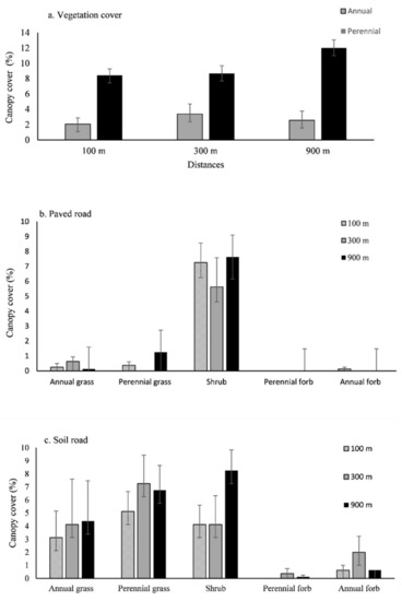
Figure 6.
(a) Total canopy cover at the three distances from the paved and soil roads. (b) Canopy cover of plant functional groups at the three distances from the paved roads. (c) Canopy cover of functional groups at the three distances from the soil roads. Each bar represents mean ± 1 SE.
Table 3.
The Jaccard distance comparing the plant communities for their species composition at the three distances from the paved and dirt roads.
The canopy cover of the plants along the soil road is double that of the vegetation along the paved road (Figure 6b). The greater canopy cover of the vegetation along the gravel road consist of annual and perennial grasses, as well as annual forbs (Figure 6c). The shrub and perennial forb canopy cover does not change depending on the road type or distance from the road. Because other functional groups’ canopy cover decreased, shrubs accounted for the majority of the total canopy cover along the paved road. The paved road’s construction may have resulted in a reduction in canopy cover. Desert herbaceous plants, in particular, are not resistant to disturbances, and the sequence of disturbances that we hypothesized in our research has an impact on their reproduction and seed banks.
3.4. The Basal Gap between Perennial Plants
Perennial plants grew closer to each other along the soil road, whereas the vegetation along the paved road had a total spacing of more than 200 cm (Figure 7). The road types had a significant impact on the gap groups of 0–50, 51–100, 101–200, and more than 200 cm for the basal distance between perennial plants. The basal gaps were unaffected by distances from the roads (Table 4).
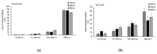
Figure 7.
The basal gap between perennial plants at the three distances from the roads. (a) The paved roads. (b) The dirt roads. Each bar represents mean ± 1.
Table 4.
Effects of road types, distances from the roads and their interaction (results of two-factor ANOVA) on the total canopy cover and functional group cover.
3.5. Biomass
Only grass biomass was affected by the different road types (Table 5). The grass biomass along the soil road is significantly higher than along the paved road. Although the biomass of other functional groups does not change significantly, forb biomass is higher along the soil road than along the paved road (Figure 8). Herbaceous plant biomass and litter mass were unaffected by distances from the road or their interaction with the road type (Table 6).
Table 5.
Results of the two-way ANOVA of the basal gap of perennial plants (road type, distance, and their interaction).
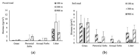
Figure 8.
Plant biomass by functional groups at the three distances from the roads. (a) The paved road. (b) The soil roads. Each bar represents mean ± 1 SE.
Table 6.
Results of the two-way ANOVA of biomass (road type, distance, and their interaction).
4. Discussion
The species diversity, canopy cover, and basal gap between perennial plants and biomass were all lower for the paved road’s vegetation than they were for the dirt road. However, dirt roads have a less negative impact on vegetation than paved roads do. The area covered by the dirt-road corridors is a large portion of the region’s pastureland. The mining corporations have suggested exploring the region until at least 2070, which means that both kinds of roads would likely grow in the next 50 years as a result of increased mining activity.
Before the mining boom, the roadless and low-traffic Gobi Desert was a very important refuge for many endangered and rare species of plants and animals, such as the Gobi bear (Ursus arctos gobiensis, Sokolov and Orlov, 1992), Mongolian wild ass (Equus hemionus hemionus Pallas), wild Bactrian camels (Camelus ferus Przewalski), cottonwood (Populus euphratica Oliv.), spotted arnebia (Arnebia guttata Bunge) and savin juniper (Juniperus sabina L.). Vegetation along both types of roads did not include plants with conservation status at the national or international level. However, rare and endangered plant species remain highly susceptible to habitat change or destruction, and every road could affect their abundance. Rare and endangered animal species’ grazing pastures could also be destroyed, fragmented, and degraded by road development.
Changes in plant communities along highways can provide high-quality pasture for herbivores. The growth of early successional plants, which many herbivores like to graze, may be encouraged by the roadside [30]. Early-stage plants with faster growth rates may green up earlier in the spring than grasses in the surrounding area, making fodder available to herbivores [31]. However, this pattern was not observed in the desert ecosystem.
There was a distinctive difference in species composition among the vegetation along the two types of roads; the vegetation along the paved road is mainly composed of shrubs while herbaceous species make up the vegetation at all distances from the dirt roads. The re-establishment of species composition is known to take more time than other values such as biomass and canopy cover [17,32]. Within 3–4 years, the vegetation along the paved road, which was completed without any reclamation efforts, has not shown signs of natural revegetation in terms of species composition and richness nor in canopy cover and biomass.
Herbaceous species are especially reduced in richness, cover, and biomass at all distances from the paved road. These herbaceous species comprise most of the rare herbivorous grazers’ diet [33]. As an exception, a few browsers, such as the wild camels, can feed on shrubs; nevertheless, high traffic and noise pollution generated from the roads do not allow the wild animals to graze freely near the paved road.
Natural revegetation in dry areas is often started by the invasion of pioneering annual plants [34,35]. The low abundance of annuals in the vegetation along the paved road could be a result of either a reduced annual rainfall of a given year or damage to soil seed banks during disturbances. A strong temporal dependence on the amount of annual rainfall results in high annual growth variability for a given year. Wet years could overwhelm the effects of disturbance on the annuals as their biomass and cover increase by multiple orders of magnitude [36]. Even though the research year of 2015 was a wetter than average year, the “rainfall” of that year did not affect the vegetation. Therefore, damage to soil seed banks could be expected in the vegetation along the paved roads. The vegetation along the paved roads was a dirt-road (gravel) corridor before the road’s development. The passage of large trucks hauling mining products, and the paved road’s construction are both disturbances that can severely damage annuals’ seeds [37].
In desert ecosystems, the distribution of perennial herbaceous plants creates spatial heterogeneity [38,39,40]. Perennials create a microhabitat with a mild microclimate by trapping litter, reducing evaporation, and increasing soil moisture and nutrients [27,41,42,43,44]. The nutrient-rich soils under perennials’ canopy facilitate soil organisms and other annuals [45,46]. Moreover, seed banks are abundant in the soils, and they are essential for plant recruitment [47]. The lack of perennial plants in the vegetation along the paved road potentially results in the natural restoration of the vegetation.
The vegetation along the dirt road corridors could be considered naturally revegetating because herbaceous species dominate in the vegetation. The dirt roads used by local herders in Mongolia’s rangeland are low traffic at most times. Mongolian herders are nomadic, and traditionally, they move seasonally four times in a year. The dirt roads are used for these seasonal movements. In the desert, the distance between movements is 40–50 km on average, longer than herders’ movement in other parts of Mongolia [48]. Since 1990, vehicle ownership among Mongolian herders has increased from nearly 0 to 100 percent for their seasonal movement, leading to a spatial extension of dirt-road corridors. Legally, land ownership in Mongolia is “communal”, suited for traditional nomadic pastoralism, but this system now allows people to freely create new road tracks and corridors and extend them. Due to the inability of constructing roads linking every herder’s seasonal camp, the formation of new dirt-road corridors is likely to increase. The environmental costs will be higher for the development of paved roads than that of the formation of dirt-road corridors. Precise and cautious monitoring and management plans for the dirt-road corridors are essential over a short period.
The results of OT mining reclamation activities have not been disclosed publicly. Although the development of paved roads avoided further deterioration of desert ecosystems, the effects of mining product transportation by dirt roads on desert vegetation between 2000 and 2010 were not taken into account by the mining or the government. In similar desert habitats, there is no attempt to revegetate after road abandonment. Therefore, both OT mining and the state must conduct a project to reclaim abandoned roads in order to expand the capacity of the rangeland area, thereby promoting rare wildlife habitat and the livelihood of local herders.
Having paved roads could be of significant socio-economic value in developing countries [49] such as Mongolia, but the environmental costs of the paved road should be cautiously considered prior to road planning. Furthermore, new legislation may be required to prevent the local population from creating or extending the dirt-road corridors in the desert.
Author Contributions
Conceptualization, S.A., A.L. and B.B. (Batkhishig Baival); methodology, S.A., A.L. and B.B. (Batkhishig Baival); validation, A.L. and S.A.; formal analysis, S.A., A.L., B.C., B.D., B.T. and B.B. (Batbileg Bayaraa); investigation, S.A., B.B. (Batkhishig Baival) and C.J.; resources, A.L.; data curation, S.A.; writing—original draft preparation, S.A.; writing—review and editing, A.L. and J.N.; visualization, B.D., B.C. and B.B. (Batbileg Bayaraa); supervision, A.L.; project administration, B.B. (Batkhishig Baival) and A.L.; funding acquisition, B.B. (Batkhishig Baival). All authors have read and agreed to the published version of the manuscript.
Funding
This research received no external funding.
Institutional Review Board Statement
Not applicable.
Informed Consent Statement
Not applicable.
Data Availability Statement
Not applicable.
Acknowledgments
We gratefully thank Eli Hornstein for his revision and improvement of the English in this manuscript. We would also like to thank Buyanbaatar Avirmed, Khishigjargal Mookhor, Baigal-Amar Tuulaikhuu, Altanzul Tsevlee, and Azjargal Jargalsaikhan for their invaluable advice, assistance, and guidance. The authors thank the staff of Nutag Partners LLC.
Conflicts of Interest
The authors declare no conflict of interest.
References
- Dulac, J. Global Land Transport Infrastructure Requirements; International Energy Agency: Paris, France, 2014; p. 20. [Google Scholar]
- Ibisch, P.L.; Hoffmann, M.T.; Kreft, S.; Pe’er, G.; Kati, V.; Biber-Freudenberger, L.; Selva, N. A global map of roadless areas and their conservation status. Science 2016, 354, 1423–1427. [Google Scholar] [CrossRef] [PubMed]
- Keshkamat, S.S.; Tsendbazar, N.E.; Zuidgeest, M.H.P.; van Der Veen, A.; de Leeuw, J. The environmental impact of not having paved roads in arid regions: An example from Mongolia. Ambio 2012, 41, 202–205. [Google Scholar] [CrossRef][Green Version]
- National Statistical Office. Available online: https://www.nso.mn/ (accessed on 12 December 2021).
- Onon, R. Current Status of Road Destinations Connected to Asian Highway Network. In Proceedings of the 8th Meeting of the Central Asia Regional Economic Cooperation (CAREC), Ulaanbaatar, Mongolia, 24–25 June 2010. [Google Scholar]
- NUM Institute of Economy (Institute of Economy at National University of Mongolia). Report: Policy Research on Roads, Transportation and Logistics of Gobi Region of Mongolia; NUM Institute of Economy: Ulaanbaatar, Mongolia, 2018; p. 256. (In Mongolian) [Google Scholar]
- National Statistical Office of Mongolia. Mongolian Statistical Yearbook 2019; National Statistical Office of Mongolia: Ulaanbaatar, Mongolia, 2008; p. 570. [Google Scholar]
- Janz, L. Chronology of Post-Glacial Settlement in the Gobi Desert and the Neolithization of Arid Mongolia and China. Ph.D. Thesis, The University of Arizona, Tucson, AZ, USA, 2012. [Google Scholar]
- Augugliaro, C.; Paniccia, C.; Janchivlamdan, C.; Monti, I.E.; Boldbaatar, T.; Munkhtsog, B. Mammal inventory in the Mongolian Gobi, with the southeasternmost documented record of the snow leopard, Panthera uncia (Schreber, 1775), in the country. J. Vegetos 2019, 15, 565–578. [Google Scholar] [CrossRef]
- Buuveibaatar, B.; Strindberg, S.; Kaczensky, P.; Payne, J.; Chimeddorj, B.; Naranbaatar, G.; Amarsaikhan, S.; Dashnyam, B.; Munkhzul, T.; Purevsuren, T.; et al. Mongolian Gobi supports the world’s largest populations of khulan Equus hemionus and goitered gazelles Gazella subgutturosa. Check List 2017, 51, 639–647. [Google Scholar] [CrossRef]
- Reading, R.P.; Mix, H.; Lhagvasuren, B.; Blumer, E.S. Status of wild Bactrian camels and other large ungulates in South-Western Mongolia. Oryx 1999, 33, 247–255. [Google Scholar] [CrossRef]
- Batjargal, Z.; Dulam, J.; Chung, Y. Dust storms are an indication of an unhealthy environment in East Asia. Environ. Monit. Assess. 2006, 114, 447–460. [Google Scholar] [CrossRef]
- Jackson, S.L. Dusty roads and disconnections: Perceptions of dust from unpaved mining roads in Mongolia’s South Gobi province. Geoforum 2015, 66, 94–105. [Google Scholar] [CrossRef]
- Zhou, C.; Gui, H.; Hu, J.; Ke, H.; Wang, Y.; Zhang, X. Detection of new dust sources in Central/East Asia and their impact on simulations of a severe sand and dust storm. JGR Atmos. 2019, 124, 10232–10247. [Google Scholar] [CrossRef]
- Hall, J.A. The Effects of Disturbance on Desert Soils, Vegetation and Community Processes with Emphasis on Off Road Vehicles: A Critical Review; U.S. Department of the Interior, Bureau of Land Management: Grand Junction, CO, USA, 1980.
- Webb, R.H.; Wilshire, H.G.; Henry, M.A. Natural Recovery of Soils and Vegetation Following Human Disturbance. In Environmental Effects of Off-Road Vehicles; Springer: New York, NY, USA, 1983. [Google Scholar]
- Li, S.-G.; Tsujimura, M.; Sugimoto, A.; Davaa, G.; Sugita, M. Natural recovery of steppe vegetation on vehicle tracks in central Mongolia. J. Biosci. 2006, 31, 85–93. [Google Scholar] [CrossRef]
- Brown, G.; Schoknecht, N. Off-road vehicles and vegetation patterning in a degraded desert ecosystem in Kuwait. J. Arid Environ. 2001, 49, 413–427. [Google Scholar] [CrossRef]
- The World Bank. A Review of Environmental and Social Impacts in the Mining Sector. [2016-08-18]. 2010. Available online: http://siteresources.worldbank.org/INTMONGOLIA/Resources/Mongolia-Mining.pdf (accessed on 3 March 2021).
- Jantumen, J.; Saarinen, K.; Valtonen, A.; Saarino, S. Grassland vegetation along to roads differing size and traffic density. Ann. Bot. Fennici 2006, 43, 107–117. [Google Scholar]
- Brown, E.W. Impacts of Dirt and Gravel Road Dust on Roadside Organic Forest Soils and Roadside Vegetation. Master’s Thesis, The Pennsylvania State University, State College, PA, USA, 2009. [Google Scholar]
- Andrew, M.F. The effects of dust on vegetation—A review. Environ. Pollut. 1993, 79, 63–75. [Google Scholar]
- Donaldson, A.; Bennett, A. Ecological Effects of Roads. Implications for the Internal Fragmentation of Australian Parks and Reserves; Deakin University: Geelong, Australia, 2004. [Google Scholar]
- Benítez-López, A.; Alkemade, R.; Verweij, P.A. The impacts of roads and other infrastructure on mammal and bird populations: A meta-analysis. Biol. Conserv. 2010, 143, 1307–1316. [Google Scholar] [CrossRef]
- Maděra, P.; Kovář, P.; Vojta, J.; Volařík, D.; Úradníček, L.; Salašová, A.; Koblížek, J.; Jelínek, P. Vegetation succession along new roads at Soqotra Island (Yemen): Effects of invasive plant species and utilization of selected native plant resistence against disturbance. J. Landsc. Ecol. 2014, 6, 46–59. [Google Scholar] [CrossRef]
- Rashtian, A. Effects of dirt roads on vegetation and diversity in arid rangelands (Case study: Aliabad Pyshkoh of Yazd, Iran). Vegetos 2016, 29, 3. [Google Scholar] [CrossRef]
- Yin, C.H.; Feng, G.; Zhang, F.S.; Tian, C.Y.; Tang, C. Enrichment of soil fertility and salinity by tamarisk in saline soils on the northern edge of the Taklimakan Desert. Agric. Water Manag. 2010, 97, 1978–1986. [Google Scholar] [CrossRef]
- Jackson, S.L. Imagining the mineral nation: Contested nation-building in Mongolia. Natl. Pap. 2015, 43, 437–456. [Google Scholar] [CrossRef]
- Assaad, H.I.; Hou, Y.; Zhou, L.; Carroll, R.J.; Wu, G. Rapid publication-ready MS-Word tables for two-way ANOVA. Springer Plus 2015, 4, 33. [Google Scholar] [CrossRef]
- Rea, R.V. Modifying roadside vegetation management practices to reduce vehicular collisions with moose Alces alces. Wildl. Biol. 2003, 9, 81–91. [Google Scholar] [CrossRef]
- Ng, J.W.; Nielsen, C.S.; Clair, C.C. Landscape and traffic factors influencing deer–vehicle collisions in an urban enviroment. Hum. Wildl. Confl. 2008, 2, 34–47. [Google Scholar]
- Lovich, J.; Bainbridge, D. Anthropogenic degradation of the southern California desert ecosystem and prospects for natural recovery and restoration. Environ. Manag. 1999, 24, 309–326. [Google Scholar] [CrossRef] [PubMed]
- Tewari, A.; Bhatt, J.; Mittal, A. Influence of tree water potential in inducing flowering in Rhododendron arboreum in the central Himalayan region. iForest 2016, 9, 842–846. [Google Scholar] [CrossRef]
- Abella, S.R. Disturbance and plant succession in the Mojave and Sonoran Deserts of the American Southwest. Int. J. Environ. Res. Public Health 2010, 7, 1248–1284. [Google Scholar] [CrossRef]
- Abella, S.R.; Smith, S.D. Annual-perennial plant relationships and species selection for desert restoration. J. Arid Land 2013, 5, 298–309. [Google Scholar] [CrossRef]
- Ibáñez, I.; Schupp, E.W. Positive and negative interactions between environmental conditions affecting Cercocarpus ledifolius seedling survival. Oecologia 2001, 129, 543–550. [Google Scholar] [CrossRef] [PubMed]
- Kinugasa, T.; Oda, S. Effects of vehicle track formation on soil seed banks in grasslands with different vegetation in the Mongolian steppe. Ecol. Eng. 2014, 67, 112–118. [Google Scholar] [CrossRef]
- Tielborger, K.; Kadmon, R. Relationships between shrubs and annual communities in a sandy desert ecosystem: A three-year study. Plant Ecol. 1997, 130, 191–201. [Google Scholar] [CrossRef]
- Flores, J.; Jurado, E. Are nurse-protégé interactions more common among plants from arid environments? J. Arid Environ. 2003, 14, 911–916. [Google Scholar] [CrossRef]
- Allen, E.B.; Steers, R.J.; Dickens, S.J. Impacts of fire and invasive species on desert soil ecology. Rangel. Ecol. Manag. 2011, 64, 450–462. [Google Scholar] [CrossRef]
- Devitt, D.A.; Smith, S.D. Root channel macropores enhance downward movement of water in a Mojave Desert ecosystem. J. Arid Environ. 2002, 50, 99–108. [Google Scholar] [CrossRef]
- Bhark, E.; Small, E. Association between plant canopies and the spatial patterns of infiltration in Shrubland and grassland of the Chihuahuan Desert, New Mexico. Ecosystems 2003, 6, 185–196. [Google Scholar] [CrossRef]
- Schlesinger, W.H.; Raikes, J.A.; Hartley, A.E.; Cross, A.F. On the spatial pattern of soil nutrients in desert ecosystems. Ecology 1996, 77, 364–374. [Google Scholar] [CrossRef]
- Titus, J.H.; Nowak, R.S.; Smith, S.D. Soil resource heterogeneity in the Mojave Desert. J. Arid Environ. 2002, 52, 269–292. [Google Scholar] [CrossRef]
- Tewksbury, J.J.; Lloyd, J.D. Positive interactions under nurse-plants: Spatial scale, stress gradients and interference in desert plants. Ecology 2001, 81, 1544–1553. [Google Scholar]
- Yong-Zhong, S.; Xue-Fen, W.; Rong, Y.; Xiao, Y.; Wen-Jie, L. Soil fertility, salinity and nematode diversity influenced by Tamarix ramosissima in different habitats in an arid desert oasis. Environ. Manag. 2012, 50, 226–236. [Google Scholar] [CrossRef]
- Holzapfel, C.; Mahall, B.E. Biodirectional facilitation and interference between shrubs and annuals in the Mojave Desert. Ecology 1999, 80, 1747–1761. [Google Scholar] [CrossRef]
- Gimenez, M.E.F. Sustaining the steppes: A geographical history of pastoral land use in Mongolia. Geogr. Rev. 1999, 89, 315–342. [Google Scholar] [CrossRef]
- Laurance, W.; Clements, G.; Sloan, S.; O’Connell, C.S.; Mueller, N.D.; Goosem, M.; Venter, O.; Edwards, D.B.; Phalan, B.; Balmford, A.; et al. A global strategy for road building. Nature 2014, 513, 229–232. [Google Scholar] [CrossRef]
Publisher’s Note: MDPI stays neutral with regard to jurisdictional claims in published maps and institutional affiliations. |
© 2022 by the authors. Licensee MDPI, Basel, Switzerland. This article is an open access article distributed under the terms and conditions of the Creative Commons Attribution (CC BY) license (https://creativecommons.org/licenses/by/4.0/).