Abstract
This paper uses remote sensing data from the Sanjiangyuan National Park (SNP) to explore the divergence between the boundaries of national parks and the distribution of natural habitats. Results are used to argue that these discrepancies evolve along with the potential impact of global warming. Using the example of the habitat change of snow leopards and the conflicts between local people and snow leopards, we reflect on the consequences of this divergence. Results show that divergence between the political boundaries and natural habitats as well as the consequent influence on the living conditions of local people are strikingly visible, and the effects of global warming on such conflicts are apparent. The authors conclude that both notions of ‘political boundaries’ and ‘natural habitats’ are expected to come together as the SNP region is spatially configured, while ‘global warming’ seems to be relevant as an essential reference when delimiting the region in the future. Finally, the proposal for the establishment of cooperative conservation areas is presented, emphasizing the role of cooperative governance in/around national parks.
1. Introduction
As biodiversity conservation becomes an increasingly global concern [1], national parks function as one of the most effective methods to protect biodiversity, enhance ecosystem services and improve the quality of the ecological environment. In the literature on national parks [2,3] or their near analogs such as natural reserves [4,5], the development of China’s national parks has attracted increasing attention [6,7,8,9]. In practice, the first five national parks in China, namely Sanjiangyuan National Park, Giant Panda National Park, Northeast Tiger Panther National Park, Hainan Tropical Rain Forest National Park, and Wuyishan National Park, were officially announced in 2021 at the 15th Summit of Conference of the Parties to Convention on Biological Diversity. In this paper, national parks specifically refer to repositories of outstanding natural scenery and regions for sight-seeing and carrying out scientific and cultural activities [10,11,12,13]. Distinguished from the national park model in the United States or Canada [14,15], China’s national parks represent the natural and cultural connotations of the country, integrating functions including protecting the ecological environment, developing natural resources, maintaining biodiversity, and providing recreational services. The political boundaries of each of these newly announced national parks are designated based on administrative boundaries, natural geographical boundaries, or a manual survey [16]. Two political divisions can also be identified inside each national park, in which the ‘core protected area’ refers to areas with important protection value and without human activities, and the ‘general control area’ denotes regions outside the core protected areas, allowing some human activity, but without environmental damage and resource consumption [17].
A basic characteristic of China’s national parks is their considerable geographical extent. For example, as the birthplace of the Yangtze River, the Yellow River, and the Lancang River, the Sanjiangyuan region accommodates the largest nature park in China: Sanjiangyuan National Park (SNP). SNP has a complex ecological environment that contains a wide range of unique plateau species, especially large and medium carnivore species such as snow leopards (Panthera uncia), grey wolves (Canis lupus), Tibetan brown bears (Ursus arctos), Eurasian lynx (Lynx lynx), red foxes (Vulpes vulpes), etc. A total of 85 species of mammals, 237 species of birds, and 48 species of amphibians and reptiles have thus far been identified in SNP [18]. To date, relatively little attention has been paid to the balance between ecological protection and the national park boundary divisions of China’s national parks [19,20]. In this paper, we seek to address this research lacuna by examining the divergence between the political boundaries of the national park and the distribution of natural habitats. In particular, SNP is the largest national park in China with the most complex ecosystem, and the divergences between protected area boundaries and the distribution of natural habitats are typical and have guiding significance for the future development and planning of national parks. Moreover, the specific location of SNP on the world’s third pole, the Tibetan Plateau, adds the necessity to study the protection of endangered species.
Research on national parks has long relied on boundary divisions, whereby national parks are commonly delineated based on geophysical, economic, socio-cultural, or political commonalities [21]. However, it has been recognized that the ensuing regionalization and its absolute boundaries can be supplemented by wildlife habitats in which territories are deemed ‘unbound’ [22]. The key point supporting this argument is that national parks have to encompass the habitat and connectivity needs of viable wildlife populations and accommodate the natural range of variability [21]. More specifically, this approach recognizes that in the context of global warming, the main habitats of flagship species have changed with changes in landscape types, spreading to areas of human activity [23]. Following this rationale, we attempt to understand the remit of SNP’s boundary division by describing a natural-habitat-based boundary and interpreting to what extent such boundary differs from the political-based administrative boundary.
Against this background, the objective of this paper is to examine the divergences between the existing national park boundary division and the potential impact of global warming. The habitat change of snow leopards is used as a concrete example, where the conflicts between local people and snow leopards are brought forward to elaborate on the consequences of the divergences. To this end, we adopt a habitat suitability modeling approach to map the snow leopard habitat in Sobchaye area, the eastern boundary of SNP. Changes in snow leopard habitats in the context of global warming are analyzed by triangulating different types of data, consisting of remote sensing data, ground patrols, and manual surveys carried out inside and outside the SNP. The remainder of this paper is organized as follows. The next section provides a general discussion of the previous studies on the divergence between boundaries of national parks and the distribution of natural habitats. This is followed by a section in which we introduce our data and methods. The results section is presented in three parts: the comparison of the SNP’s boundaries and the distribution of snow leopards’ habitats, a discussion of the conflicts between local people and snow leopards as the consequence of the divergence, and a discussion on the potential impact of global warming in the future evolving process of such discrepancy. We conclude with an overview of its major findings, policy implications, and suggestions for avenues of future research.
2. Divergence between Boundaries of National Parks and the Distribution of Natural Habitats
2.1. National Parks and Their Delineation
The concept of national parks originated in the United States in the early 19th century with a primary objective to protect the original ecological environment destroyed by human impact [24]. Although countries with different backgrounds have various definitions, mechanisms, objectives, and management concepts concerning national parks, they regularly follow the general definition proposed by the International Union for Conservation of Nature (IUCN). This definition clearly states that the basic goal of national parks is to permanently maintain the typical characteristics and natural conditions of geological relics, ecosystems, and biological communities, and to provide scientific, educational, recreational, and tourism opportunities [25]. Today, the construction and reform of national park systems are developing vigorously, with over 100 countries in the world having established national parks.
The delineation of national park boundaries is of great importance to the planning, construction, and management of national parks. Delineation methods and their impact on national parks have become a major research topic nowadays. Fort et al. [26] discussed that while most of the current delineation approaches delineate some core protected areas, it always conflicts with habitat distributions, particularly in terms of the impact of external factors (environmental change, human activities, etc.) due to the integrity of ecosystems. Li et al. [16] elaborated that delineating functional areas within a national park is a key element for formulating effective protection policies and completing ecological controls. These areas are usually delimited on the basis of administrative areas and natural topography, and therefore, rarely consider the integrity of the local ecosystem, habitat changes of animals, or human interference, which results in ineffective and unclear boundaries. Ruth et al. [27] investigated the activities of humans and carnivores (grizzly bears, wolves, and cougars) on Yellowstone National Park’s northern boundary, and found that they would cross the reserve boundary once hunting began. Poole et al. [21] surveyed Peary caribou distributions within the Bathurst Island in Qausuittuq National Park and used its seasonal variation to design and adjust the reserve boundaries. Berisha et al. [23] noticed that within the massif of Luboten, Sharri NP, an endangered natural habitat of subalpine moist tall herbs was not covered within the strictly protected area. Sibirkina et al. [28] presented the developed system of functional zones in the Zyuratkul National Park to ensure the safety of animals living on its territory. They revealed the general geographical features of the area and developed proposals to adjust the boundaries of previously defined functional areas based on the habitat of rare and endangered species of vertebrates.
2.2. Global Climate Change and Its Effects on Landscapes and Subsequently Habitats
Climate change is a fundamental aspect of the Anthropocene [29], and it is one of the major driving forces for landscape evolution. Changes in water and heat conditions in climate change control various ecological processes and ecosystem productivity directly or indirectly, resulting in vegetation types and landscape patterns changes [30]. The ecosystem in high-altitude areas exhibits the most sensitive and fast response to climate change. In response to global warming, many species have adjusted their phenology and physiology to match new climatic conditions [31] or shifted their distributions toward higher altitudes or latitudes in search of suitable habitats [32].
In recent years, research on climate change and its relationship with landscape typologies has received increasing attention in academia. Landscape change is related to climate change as both a causal factor and a major way in which the effects of climate change are expressed [33]—it has a direct impact on habitat distribution. Parmesan and Yohe [34] applied diverse analyses to more than 1700 species and showed that biological trends match climate change predictions. Habitats’ significant range shifted averaging 6.1 km per decade towards the poles (or meters per decade upward). Tabor et al. [35] elaborated that climate change presents an additional challenge to the effectiveness of protected areas because the global protected area network accounts for the current distribution of species and habitats, not potential future distributions. Static protected areas may be ineffective when trying to protect biodiversity during a century likely to be characterized by shifting species ranges, elevational migrations, and possible extinctions due to climate change. Segurado and Araujo [36] used seven modeling techniques to model probabilities of occurrence for 44 species of amphibians and reptiles in Portugal and estimated that 6–11% of species will be pushed out of reserved areas by the mid-21st century. Banfai and Bowman [37] compared aerial photographs of 50 rain-forest in Kakadu National Park and revealed that the rainforest was expanding beyond the national park border driven by global environmental change phenomena, such as increases in rainfall and atmospheric CO2 [38]. In general, distributions of various ecosystem landscape types have changed and will continue to change with global warming, and the scope of flagship species habitats has and will be greatly affected. This makes the existing ranges of national parks no longer meet the needs of biodiversity conservation.
COVID-19 emphasizes the fact that the pandemic has urged us to deal with climate change effects by proposing new solutions for the urban and natural environment. It changed the way many people viewed and interacted with the natural environment [39]. Resilient and sustainable cities provide a healthier and human-centered environment to deal with environmental issues and address the impacts of climate change [40].
2.3. Potential Conflicts between Anthropogenic Sources and Animals
National parks have proven effective in reducing habitat destruction and deterring some illegal activities including poaching, illegal logging, and cattle grazing [35]. However, it cannot avoid potential conflicts between anthropogenic sources and animals. Anthropogenic activities play an important role in land cover change [41]. Natural lands are becoming increasingly threatened due to deforestation and the expansion of urban areas and agricultural land. Habitat loss and fragmentation are key drivers of biodiversity loss and can increase the risk of extinction for species [42].
Human–wildlife conflict is one of the major challenges in biodiversity conservation. This often happens due to the competition between humans and wildlife for shared and limited resources. It can cause a significant loss of economic production and human life, especially in and around protected areas [43]. Large carnivores in particular are causing intensive conflicts with humans. For example, 12 people were killed and a further 4 were injured in tiger attacks during 1994–2007, and the annual loss of livestock attributable to tigers was 0.26 animals per household, amounting to an annual loss of 2% of livestock in Bardia National Park, Nepal [44]. Spotted hyena attacks during 2007–2011 caused about 30.49% of livestock losses in and around Chebera-Churchura National Park, Ethiopia, and the overall economic loss by wildlife attacks was estimated to be US$75,234 (US$83/household/year) [43].
The snow leopard is one of the typical large carnivores in our study area, and as a species, it is very sensitive to environmental changes. There are significant conflicts between humans and snow leopards, and this species has, therefore, great value for a study of national park boundary delineations. Snow leopards inhabit the mountainous regions of Central Asia, where they are thinly distributed across a vast area in excess of 1.2 million km2 [45]. The habitat range of snow leopard has changed significantly in recent years because of global warming [46]; nature reserves protect 38.78% of currently suitable habitats and will protect 42.56% of future suitable habitats [47]. This also implies that more than half of snow leopards are distributed outside nature reserves. Gradual invasion of habitats into human activity areas (or the other way round) lead to increasingly serious conflicts between snow leopards and humans [18,48,49]. The economic loss because of large carnivores (snow leopards and wolves) in the Spiti region of the Indian Trans-Himalaya was earlier estimated to be US$128 per family annually, amounting for about half the per capita income of the state [50]. Obviously, existing boundary demarcation methods of national parks cannot meet the protection needs of snow leopards and their habitats. There are a large number of grasslands and villages in the boundary areas of national parks, and these areas are also often the potential habitat of snow leopards. Furthermore, in addition to carrying out patrolling and monitoring for the purpose of protection, human activities dominated by infrastructure construction often occur in habitats, such as mineral resources exploiting, construction of highways, railways, water conservancy projects, and so on, which has further increased the conflict between snow leopards and humans.
3. Materials and Methods
3.1. Study Area
Sanjiangyuan National Park (SNP) is the first national park in China, located in the hinterland of the Qinghai-Tibet Plateau. It covers 123,100 km2 and accounts for 31.16% of the entire area of the Sanjiangyuan [51]. It consists of three areas: the Yangtze River Source, the Yellow River Source, and the Lancang River Source. In this paper, the case study area Sobchaye (33.34–33.88 N and 94.58–95.63 E) lies on the eastern edge of SNP. It is a major snow leopard habitat with a surface of 5798 km2 at an average elevation of 4927 m (see Figure 1). It sits between the Lancang River and the Yangtze River sources and includes glaciers, alpine flow rocks, alpine grasslands, alpine lakes, and other habitats. Sobchaye has a unique geographical location and an ecological environment, has complex terrain and diverse natural environment types, and is a typical mountain landscape on the Tibetan Plateau. In recent years, glaciers have been melting at a high rate because of global warming [52]. Sobuchaye also harbors an animal husbandry community. The main settlement is Dasheng Village in the northeast of Figure 1, accommodating over 600 households. According to the observations of Karki and Panthi [53], the impact of local human activities on snow leopard habitats in this area is marked due to the construction of roads. The mining ore belt also brings an unprecedented threat to the balance of the local ecosystem.
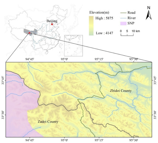
Figure 1.
The case study area (Sobchaye).
3.2. Habitat Mapping
Our habitat mapping draws on the habitat suitability scoring approach of Forrest et al., in which suitability classes are provided a corresponding score, with unsuitable classes scoring 0 [54]. The layers were weighted equally and summed. Because the available snow leopard observation data were not collected systematically with respect to the studied environmental layers, we did not use a statistical modeling approach (e.g., generalized linear model of snow leopard presence and absence, maximum entropy model, etc.) to map the snow leopard habitat. The indicators and their scores are mainly based on previous studies on the main factors influencing snow leopard habitat [55,56,57,58,59], in which altitude, ruggedness, temperature, precipitation, etc. are all important parameters. Eight bioclimatic variables were chosen to define snow leopard habitat from three perspectives: topographies and landscapes, human activities, and climates, with each pixel having eight suitability scores, one for each of the eight factors detailed in Table 1.

Table 1.
Class and scores are used to map dispersal habitat.
The fieldwork results showed that most snow leopards live at an altitude between 4400 m and 4900 m, with areas above 5400 m not offering a good habitat for snow leopards. It was shown in the literature that only 10% of snow leopard observation points fell between 5000 m and 5500 m and 1% between 5500 m and 6000 m in Sanjiangyuan [54], a slightly higher altitude than the study area. Snow leopards mainly live in bare rock areas and show a strong preference for steep and rugged terrains [60]. There is relatively little competition among species in areas with severer ruggedness, and steep mountains and palisades provide shelter for snow leopards [61]; therefore, bare rock, high slope, and severely rugged areas were assigned higher scores. The scores of distance to roads or rivers are lower because they are not the main factor even though they have some influence on the habitat [61]. Temperature and precipitation are very important environmental factors. Relatively speaking, temperature is the major climatic factor responsible for the snow leopard distributions in the energy-deficient environments of high altitudes [62]. Finally, we normalized the scores of each pixel and divided them into five grades, and defined the main snow leopard habitat with scores ranging from 0.8 to 1.0 (see Table 2).
Table 2.
Biological interpretation of habitat suitability scores.
3.3. Data Source and Processing
Digital Elevation Model (DEM) was obtained from the Geospatial Data Cloud website (http://www.gscloud.cn/sources/, accessed on 17 March 2022) at a resolution of 30 m. Vector data, such as rivers, roads, and administrative boundaries, were downloaded from the Water Information Service Explorer website (http://www.zkyq-tech.cn/, accessed on 11 March 2022) and SNP boundary data were downloaded from the Tibetan Plateau Science Data Center (TPDC) (https://data.tpdc.ac.cn/zh-hans/, accessed on 17 March 2022). We calculated the slope and ruggedness of the study area by DEM using ArcGIS 10.0 respectively and got the scored raster layers of DEM, slope, and ruggedness after reclassification. Buffers of 500 m and 2000 m were made for the road and river, which were then overlaid with the study area boundary, vectorized the rasterization after reclassification to get the scored raster layers for the road and river.
Landscape type data of Sobchaye were derived from the Gaofen-1 series of remote sensing images at a resolution of 16 m, downloaded from the China Center for Resources Satellite Data and Application (http://www.cresda.com/CN/, accessed on 2 July 2021). We chose ten images for which the cloud cover was less than 10% in July or August in Sobchaye from 2010 to 2020. ENVI 5.1 was used to preprocess and resample remote sensing images for different periods. These images were classified by an unsupervised classification method, after which incorrect classifications were corrected by manual visual interpretation to obtain the distribution results of landscape types in the study area.
Meteorological data (temperature and precipitation) were obtained from the Famine Early Warning Systems Network Land Data Assimilation System (FLDAS) (https://disc.gsfc.nasa.gov/, accessed on 25 March 2022), a land-based data assimilation system with a spatial resolution of 0.1 × 0.1°, provided by the National Aeronautics and Space Administration (NASA) and the Famine Early Warning Systems Network (FEWS NET) with a monthly temporal resolution. Since the resolution of the original data was too low to meet the requirements, 95 grid points were evenly extracted according to latitude and longitude and an inverse distance weight interpolation was implemented. The interpolated results were exported to the Tagged Image File Format (TIF) format, and resampled with the same resolution as the DEM, reclassified to get the scored raster layers of temperature and precipitation.
3.4. Patrol and Camera Trap
The biodiversity patrol monitoring team was established in Sobchaye to verify the accuracy of the habitat map and consists of 21 experienced herders. We designed four patrol routes between Dasheng Village and the main peak of the case study area, and conducted patrols during April, August, and November of 2019 (see Figure 2). To reduce potential errors, each patrol route was traversed more than twice and uncertain parts were eliminated after repeated confirmation.
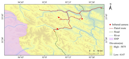
Figure 2.
The patrol route of the research team in Sobchaye.
In addition, the research team performed a large number of surveys and interviews in the field as well as recorded wildlife events by GPS. Camera traps were set up and controlled during the science expeditions in three points where snow leopards frequently occurred. The camera traps were installed in favorable places where the research team found signs of snow leopard presence on narrow passes, along cliffs, facing large rocks, etc. [63]. Each camera trap was fixed to a rock with a strap at around fifty centimeters to one meter from the ground, where it would not be disturbed by other factors. The research team performed a manual identification based on the unique patterns of the animals’ fur rosettes [64] and excluded snow leopard individuals with obvious repetition accordingly. In total, five snow leopards were caught on camera.
4. Results
4.1. Habitat Distribution
The habitats of snow leopards were identified by overlaying altitude, slope, river, road, and other data, and reclassified according to suitability degree (see Figure 3). The potential habitats of snow leopards (scores range from 0.8 to 1.0) in the Sobchaye area covered 948 km2, accounting for 13.8% of the total area. The area mainly covers the southern and eastern parts of the study area, while the potential habitat within the national park only accounts for 7% of the entire habitat area. Thus, the potential habitats of snow leopards were mostly distributed outside the national park in light of global climate change and grassland degradation. After field verification, we found that the distribution results were broadly consistent with the findings of surveys and interviews.
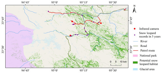
Figure 3.
The main potential snow leopard habitats in Sobchaye.
In addition, there was a large overlap area between snow leopard habitats and human activity regions. Flagship species are unaffected by human factors in national parks, but roads, human settlements, or other infrastructures will have a great impact on habitats outside national parks. Potential snow leopard habitats were greatly affected by local roads, villages, and populations. In the process of our field investigation, two shots were taken that show a snow leopard breaking into the village (see Figure 4), both occurring during the winter months. We speculate that snow leopards clashed with local herdsmen because of food shortages and they had to find new sources of food in winter.
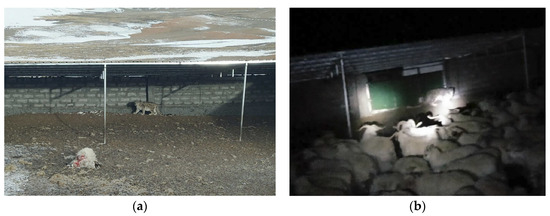
Figure 4.
Photo records of snow leopards breaking into human settlements. (a) Occurred in the day; (b) Occurred in the night.
Based on the same method, we counted the habitats of snow leopards in Sanjiangyuan region. The snow leopard habitat consisted of 85,778 km2, accounting for 23.4% of the total areas in Sanjiangyuan. Most of the snow leopards’ potential habitats are located outside the national park, mainly including the areas east of Lancang River National Park and the areas east and south of the Yellow River National Park. Moreover, habitats inside the national park concentrate in the southeast of Lancang River National Park. Thus, it seems urgent to adapt and adjust the national park boundaries to these snow leopard habitats.
4.2. Snow Leopard Habitat Changes under Climate Scenarios
A likely significant factor in assessing the future boundaries of a national park is climate change [21]. As shown in Table 3, we divided the landscape types of Sobchaye into three categories, namely ‘vegetation’, ‘bare rock’, and ‘glacial area’, and compared these types with three major indicators of climate change, namely ‘temperature’, ‘precipitation’, and ‘sunshine duration’. The category of ‘vegetation’ was further divided into three subgroups, namely ‘high-coverage vegetation’, ‘medium-coverage vegetation’, and ‘low-coverage vegetation area’. The results showed that the bare rock area has increased by 6.7% from 2010 to 2020. In contrast, the vegetation and glacial areas have decreased by 2.1% and 6.2% (see Figure 5a). When taking a detailed look at the category of ‘vegetation’, the ‘high-coverage vegetation’ area presented a clear continued decrease, the ‘medium-coverage vegetation’ area showed a slight decrease, and the ‘low-coverage vegetation’ area continued to increase (see Figure 5b).
Table 3.
Landscape classification and climate change indicators in Sobchaye.
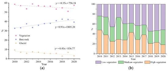
Figure 5.
(a) Annual changes in landscape categories; (b) The changes in vegetation typologies.
The snow line has been rising in Sobchaye with global warming. The habitats of snow leopards shift with these climate changes. The relations between the climate factors and the landscape types in the case study area were researched and revealed that the trends of the temperature and landscape types were consistent with the annual changes in landscape types, while other climate factors, such as precipitation and sunshine, showed significant fluctuations. The results suggest that the change in landscape types is mainly related to the change in temperature. In the 10 years from 2010 to 2020, the average temperature in the study area increased by about 1.39 °C. Bare rock increased by 0.9% per year, vegetation and glacial area decreased by 0.3% and 0.4%. The other 0.2% is mainly used for the construction of infrastructure and settlement (see Figure 6). It can be predicted that by 2030, the bare rock area will increase by 7.05%, vegetation and the glacial area will decrease by 6.88% and 1.92%.
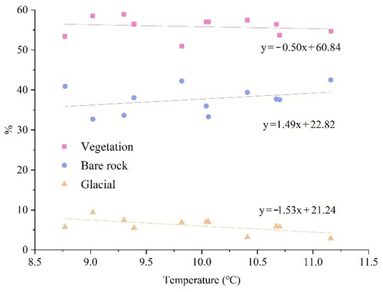
Figure 6.
The proportional relationship between landscape categories and mean annual temperature in Sobchaye.
Areas outside of the current national park boundaries are important for the protection of snow leopards in Sanjiangyuan. Affected by a series of severe winters, the snow leopard’s range of activities has gradually expanded beyond the scope of the national park. Mainly caused by overgrazing, the grasslands in Sanjiangyuan have been seriously degraded. The snow line, therefore, became higher due to the increase in temperature and precipitation, which led to the expansions of the snow leopard’s habitats to higher and lower altitudes. Moreover, human activities triggered the fragmentation of habitats, which reduced the large-scale core habitat.
4.3. Verification of Results
The patrol was divided into four routes. In total, 87 recorded points were obtained after screening. Among them, 15 points were where snow leopards had been seen in recent years, 18 points were locations where carnivores were identified except for snow leopards, 28 points were locations with herbivores, and 26 points were other functional locations, such as scenic spots, mining sites, water sources, etc. Most snow leopard records were in the snow leopard habitat. However, the results had some limitations because the patrol was mainly carried out along roads, and the areas in deep mountains could not be reached for field investigation due to inconvenient transportation and other severely challenging natural conditions.
5. Discussion
China’s national parks are managed on a territorial model in which administrative divisions often play a dominant role, but most threats come from adjacent areas outside the national parks rather than from the inside. The boundaries of the national park decreasingly adequately capture the main habitats of the flagship species in SNP, especially large carnivores such as the widely dispersed snow leopards. The potential habitats are increasingly outside the core protected areas, and these species are therefore less protected by national policies and also inevitably more affected by human activities (including mining, grazing, infrastructure construction, etc.). In addition, control of the flagship species is sparse outside the protected areas, which can more easily lead to their death.
As a consequence, stakeholders should pay more attention to biodiversity protection outside the national parks. Firstly, country and local authorities should attach importance to this issue, reorient the scope of national parks for potential habitats, and minimize human interference with the flagship species. Secondly, indigenous peoples are important for global biodiversity conservation, as they occupy and use such lands and waters that harbor biodiversity [65]. Due to the wide distribution of the flagship species, it is also undesirable to blindly expand the range of core protected areas, which is equivalent to depriving local herdsmen of the power to use land resources. Therefore, it is necessary to awaken the local people’s awareness of environmental and biodiversity conservation and promote their environmental autonomous governance. Thirdly, businesses and third-party organizations (environmental organizations, scientific research institutions, etc.) make rational utilization of the natural and cultural resources in parks, establish a co-win partnership, and strengthen publicity and education in the border areas of national parks. In general, nested management of institutions on different scales makes the boundary areas prone to regulatory gaps and management loopholes, and it is imperative to strengthen cooperation in/around national parks.
We propose the establishment of collaborative protected areas beyond core protected areas as buffers for the interface between humans and wild animals [66,67]. A multi-subject cooperative governance framework that is government led (represented by the park management agency) involving enterprises, community residents, and non-governmental organizations was formed in this region [19] to solve the problems of management disorder and governance fragmentation in the national park system and achieve the sustainability of protection and development. Cooperative conservation areas can provide an effective model for different regions in Sanjiangyuan to achieve a transboundary protection partnership, and integrate the conservation policies of the flagship species within and outside the national park. A transboundary protection partnership would help to support biodiversity and ecosystem protection and expedite the development of local communities in SNP. In this regard, establishing collaborative conservation areas is an important way to alleviate conflicts between flagship species and humans outside the core protected areas. Because of the goal of making an in-depth case study of national park boundary delineation, this paper focused on the approach of establishing collaborative protected areas in national park boundary adjustment. However, as Fikret Berkes asserted, co-management as a partnership also involves knowledge generation, bridging organizations, social learning, etc. [68] Accessing resources, bringing together different actors, building trust, resolving conflict, and networking are all important steps [69,70]. This also sets up more runways for our future research, which we will refer to in the next studies.
6. Conclusions
Through boundary divergence, we presented the future arena for the national park study to provide some theoretical basis for national park development and biodiversity conservation. Taking SNP as a case, we mapped snow leopard habitats to clarify the conflict between SNP boundaries and snow leopard habitats and highlighted the impacts of climate changes and human activities on natural habitats to promote the sustainable development of SNP. The following conclusions are formulated:
- (1)
- The habitats of snow leopards are changing in line with the environment. In Sobchaye in particular, bare rock area increased by 0.9% per year from 2010 to 2020, while vegetation and glacial area decreased by 0.3% and 0.4%. The other 0.2% is mainly used for the construction of infrastructure and settlement. The change of landscape types was mainly related to temperature, and snow leopards thereupon spreading to higher and lower latitudes, respectively.
- (2)
- Because the habitats of the flagship species showed obvious signs of migration, the existing park boundaries no longer adequately capture habitats. The artificially delimited boundaries decreasingly cover the protected region of animals and plants, especially in areas undergoing greater environmental changes. Only 7% of the snow leopard habitat was within the national park in Sobchaye. Therefore, more attention should be given to the integrity of ecosystems and the habitat range of major flagship species in the delineation of national park boundaries.
- (3)
- The capabilities of national parks have been challenged in many parts of the world. Even protected areas established in erstwhile remote areas have begun to experience the effects of growing anthropogenic influences, whether from resource appropriation (hunting, gathering plant products, etc.), tourism, encroachment, or invasion [24]. Contradictions between human and protected areas are increasingly prominent. Relevant authorities need to emphasize habitat protection outside the national park. Cooperative governance between different stakeholders in/around national parks is a strong prerequisite.
The research presented here is exploratory and can be improved and extended in many ways in future research. First, the analysis is circumscribed by the model. Only a linear regression model was fitted to simulate future natural habitat changes under global warming because of a realistic situation. This implies that the results may differ from those required by the complexity and diversity of the ecosystem. Future research could try to construct a comprehensive model integrating most of the influencing factors. Second, the target of this paper is large carnivores among the flagship species. However, biodiversity conservation is not limited to flagship species but relates to the entire biosphere. It will be tried to expand to other fields in wildlife conservation to serve a broader biodiversity objective in the future. Third, and finally, divergences between national park boundaries and natural habitats need to be further captured in the framework of cooperative conservation, and exploring sustainable development pathways besides adjusting park boundaries for further research.
Author Contributions
Conceptualization, X.F. and W.L.; methodology, W.L. and Q.P.; software, Q.P.; validation, Y.C.; formal analysis, X.F. and Q.P.; resources, W.L.; writing—original draft preparation, Q.P.; writing—review and editing, X.F.; visualization, Q.P.; funding acquisition, X.F. and W.L. All authors have read and agreed to the published version of the manuscript.
Funding
This research was funded by the National Natural Science Foundation of China, grant number 42171389, and the Ministerial Social Science Research Project of Ministry of Culture and Tourism of China, grant number 22DY17.
Institutional Review Board Statement
Not applicable.
Data Availability Statement
The data that support the findings of this study include DEM from the Geospatial Data Cloud website (http://www.gscloud.cn/sources/, accessed on 17 March 2022), vector data from the Water Information Service Explorer website (http://www.zkyq-tech.cn, accessed on 11 March 2022/), SNP boundary data from the Tibetan Plateau Science Data Center (TPDC) (https://data.tpdc.ac.cn/zh-hans/, accessed on 17 March 2022), meteorological data from the Famine Early Warning Systems Network Land Data Assimilation System (FLDAS) (https://disc.gsfc.nasa.gov/, accessed on 25 March 2022), remote sensing data from the China Center for Resources Satellite Data and Application (http://www.cresda.com/CN/, accessed on 2 July 2021), and field investigation data from the Qinghai Snowland Great Rivers Environmental Protection Association and the Shanghai Yangtze River Delta Human Ecology Science and Technology Development Center.
Conflicts of Interest
The authors declare no conflict of interest.
References
- Pathak, M.R.; Abido, M.S. The role of biotechnology in the conservation of biodiversity. J. Exp. Biol. 2014, 2, 352–363. [Google Scholar]
- Sutton, P.C.; Duncan, S.L.; Anderson, S.J. Valuing Our National Parks: An Ecological Economics Perspective. Land 2019, 8, 54. [Google Scholar] [CrossRef]
- Gavilanes Montoya, A.V.; Esparza Parra, J.F.; Chavez Velasquez, C.R.; Tito Guanuche, P.E.; Parra Vintimilla, G.M.; Mestanza-Ramon, C.; Vizuete, D.D.C. A Nature Tourism Route through GIS to Improve the Visibility of the Natural Resources of the Altar Volcano, Sangay National Park, Ecuador. Land 2021, 10, 884. [Google Scholar] [CrossRef]
- Rocchini, D.; Perry, G.L.W.; Salerno, M.; Maccherini, S.; Chiarucci, A. Landscape change and the dynamics of open formations in a natural reserve. Landsc. Urban Plan. 2006, 77, 167–177. [Google Scholar] [CrossRef]
- Sanchez-Martin, J.-M.; Rengifo-Gallego, J.-I.; Sanchez-Rivero, M. Protected Areas as a Center of Attraction for Visits from World Heritage Cities: Extremadura (Spain). Land 2020, 9, 47. [Google Scholar] [CrossRef]
- Dong, Q.; Zhang, B.; Cai, X.; Morrison, A.M. Do Local Residents Support the Development of a National Park? A Study from Nanling National Park Based on Social Impact Assessment (SIA). Land 2021, 10, 1019. [Google Scholar] [CrossRef]
- Foggin, J.M. Environmental Conservation in the Tibetan Plateau Region: Lessons for China’s Belt and Road Initiative in the Mountains of Central Asia. Land 2018, 7, 52. [Google Scholar] [CrossRef]
- Gao, Y.; Zou, L.; Morrison, A.M.; Wu, F. Do Situations Influence the Environmentally Responsible Behaviors of National Park Visitors? Survey from Shennongjia National Park, Hubei Province, China. Land 2021, 10, 891. [Google Scholar] [CrossRef]
- Lu, Z. Add Himalayas’ Grand Canyon to China’s first national parks. Nature 2021, 592, 353. [Google Scholar]
- Ma, X.L.; Ryan, C.; Bao, J.G. Chinese national parks: Differences, resource use and tourism product portfolios. Tour. Manag. 2009, 30, 21–30. [Google Scholar] [CrossRef]
- Tang, F.; Yan, Y.; Liu, W. Construction progress of national park system in China. Biodivers. Sci. 2019, 27, 123–127. [Google Scholar]
- Wang, G.; Innes, J.L.; Wu, S.W.; Krzyzanowski, J.; Yin, Y.; Dai, S.; Zhang, X.; Liu, S. National Park Development in China: Conservation or Commercialization? Ambio 2012, 41, 247–261. [Google Scholar] [CrossRef] [PubMed]
- He, S.; Su, Y.; Wang, L.; Gallagher, L.; Cheng, H. Taking an ecosystem services approach for a new national park system in China. Resour. Conserv. Recycl. 2018, 137, 136–144. [Google Scholar] [CrossRef]
- Timko, J.A.; Innes, J.L. Evaluating ecological integrity in national parks: Case studies from Canada and South Africa. Biol. Conserv. 2009, 142, 676–688. [Google Scholar] [CrossRef]
- Byrne, J.; Wolch, J.; Zhang, J. Planning for environmental justice in an urban national park. J. Environ. Plan. Manag. 2009, 52, 365–392. [Google Scholar] [CrossRef]
- Li, J.; Li, W.; Fu, J.; Gao, J.; Yang, L.; He, W. Using low-altitude UAV remote sensing to identify national park functional zoning boundary: A case study in Qianjiangyuan National Park pilot. Biodivers. Sci. 2019, 27, 42–50. [Google Scholar]
- Fu, M.; Tian, J.; Ren, Y.; Li, J.; Liu, W.; Zhu, Y. Functional zoning and space management of Three-River-Source National Park. J. Geogr. Sci. 2019, 29, 2069–2084. [Google Scholar] [CrossRef]
- Li, J.; Yin, H.; Wang, D.; Jiagong, Z.; Lu, Z. Human-snow leopard conflicts in the Sanjiangyuan Region of the Tibetan Plateau. Biol. Conserv. 2013, 166, 118–123. [Google Scholar] [CrossRef]
- Zhang, C.; Guo, X.; Weng, S.; Gao, J.; Fu, J. Cross-border governance system construction of Qianjiangyuan National Park pilot by referring to the experience of French regional parks. Biodivers. Sci. 2019, 27, 97–103. [Google Scholar]
- Ma, B.; Zeng, W.; Xie, Y.; Wang, Z.; Hu, G.; Li, Q.; Cao, R.; Zhuo, Y.; Zhang, T. Boundary delineation and grading functional zoning of Sanjiangyuan National Park based on biodiversity importance evaluations. Sci. Total Environ. 2022, 825, 154068. [Google Scholar] [CrossRef]
- Poole, K.G.; Gunn, A.; Wierzchowski, J.; Anderson, M. Peary caribou distribution within the Bathurst Island Complex relative to the boundary proposed for Qausuittuq National Park, Nunavut. Rangifer 2015, 35, 81–98. [Google Scholar] [CrossRef][Green Version]
- Qamar, F.M.; Ali, H.; Ashraf, S.; Daud, A.; Gillani, H.; Mirza, H.; Rehman, H.U. Distribution and habitat mapping of key fauna species in selected areas of western himalaya, pakistan. J. Anim. Plant Sci. 2011, 21, 396–399. [Google Scholar]
- Berisha, N.; Custerevska, R.; Lluga-Rizani, K.; Millaku, F.; Matevski, V. Relation between boundaries of protected areas and the distribution of vulnerable natural habitats—A case study from Sharri National Park, SE Europe. Ecol. Quest. 2021, 32, 1–18. [Google Scholar] [CrossRef]
- Funch, R.R.; Harley, R.M. Reconfiguring the boundaries of the Chapada Diamantina National Park (Brazil) using ecological criteria in the context of a human-dominated landscape. Landsc. Urban Plan. 2007, 83, 355–362. [Google Scholar] [CrossRef]
- Sayan, M.S.; Atik, M. Recreation carrying capacity estimates for protected areas: A study of termessos National Park. Ekoloji 2011, 20, 66–74. [Google Scholar] [CrossRef]
- Fort, J.L.; Nielsen, C.K.; Carver, A.D.; Moreno, R.; Meyer, N.F.V. Factors influencing local attitudes and perceptions regarding jaguars Panthera onca and National Park conservation in Panama. Oryx 2018, 52, 282–291. [Google Scholar]
- Ruth, T.K.; Smith, D.W.; Haroldson, M.A.; Buotte, P.C.; Schwartz, C.C.; Quigley, H.B.; Cherry, S.; Murphy, K.M.; Tyers, D.; Frey, K. Large-carnivore response to recreational big-game hunting along the Yellowstone National Park and Absaroka-Beartooth Wilderness boundary. Wildl. Soc. Bull. 2003, 31, 1150–1161. [Google Scholar]
- Sibirkina, A.f.R.e.; Trofimova, L.V.; Kuzmishchev, N.N. National park “Zyuratkul” (Chelyabinsk region) functional zones correction along habitat borders of vertebrate rare species. Les. Vestnik. For. Bull. 2021, 25, 41–50. [Google Scholar] [CrossRef]
- Perdinan; Winkler, J.A. Changing Human Landscapes Under a Changing Climate: Considerations for Climate Assessments. Environ. Manag. 2014, 53, 42–54. [Google Scholar] [CrossRef]
- Yin, H.J.; Liu, Q.; Lai, T. Warming effects on growth and physiology in the seedlings of the two conifers Picea asperata and Abies faxoniana under two contrasting light conditions. Ecol. Res. 2008, 23, 459–469. [Google Scholar] [CrossRef]
- Walther, G.-R.; Post, E.; Convey, P.; Menzel, A.; Parmesan, C.; Beebee, T.J.C.; Fromentin, J.-M.; Hoegh-Guldberg, O.; Bairlein, F. Ecological responses to recent climate change. Nature 2002, 416, 389–395. [Google Scholar] [CrossRef] [PubMed]
- Long, T.; Tang, J.; Pilfold, N.; Zhao, X.; Dong, T. Predicting range shifts of Davidia involucrata Ball. under future climate change. Ecol. Evol. 2021, 11, 12779–12789. [Google Scholar] [CrossRef] [PubMed]
- Dale, V.H. The relationship between land-use change and climate change. Ecol. Appl. 1997, 7, 753–769. [Google Scholar] [CrossRef]
- Parmesan, C.; Yohe, G. A globally coherent fingerprint of climate change impacts across natural systems. Nature 2003, 421, 37–42. [Google Scholar] [CrossRef] [PubMed]
- Tabor, K.; Hewson, J.; Tien, H.; Gonzalez-Roglich, M.; Hole, D.; Williams, J.W. Tropical Protected Areas Under Increasing Threats from Climate Change and Deforestation. Land 2018, 7, 90. [Google Scholar] [CrossRef]
- Segurado, P.; Araujo, M.B. An evaluation of methods for modelling species distributions. J. Biogeogr. 2004, 31, 1555–1568. [Google Scholar] [CrossRef]
- Banfai, D.S.; Bowman, D.M.J.S. Drivers of rain-forest boundary dynamics in Kakadu National Park, northern Australia: A field assessment. J. Trop. Ecol. 2007, 23, 73–86. [Google Scholar] [CrossRef]
- Jiang, Q.; Li, W.; Fan, Z.; He, X.; Sun, W.; Chen, S.; Wen, J.; Gao, J.; Wang, J. Evaluation of the ERA5 reanalysis precipitation dataset over Chinese Mainland. J. Hydrol. 2021, 595, 125660. [Google Scholar] [CrossRef]
- Mell, I.; Whitten, M. Access to Nature in a Post Covid-19 World: Opportunities for Green Infrastructure Financing, Distribution and Equitability in Urban Planning. Int. J. Environ. Res. Publ. Health 2021, 18, 1527. [Google Scholar] [CrossRef]
- Balletto, G.; Ladu, M.; Milesi, A.; Camerin, F.; Borruso, G. Walkable City and Military Enclaves: Analysis and Decision-Making Approach to Support the Proximity Connection in Urban Regeneration. Sustainability 2022, 14, 457. [Google Scholar] [CrossRef]
- Hamad, R.; Balzter, H.; Kolo, K. Multi-Criteria Assessment of Land Cover Dynamic Changes in Halgurd Sakran National Park (HSNP), Kurdistan Region of Iraq, Using Remote Sensing and GIS. Land 2017, 6, 18. [Google Scholar] [CrossRef]
- Zeller, K.A.; Lewsion, R.; Fletcher, R.J., Jr.; Tulbure, M.G.; Jennings, M.K. Understanding the Importance of Dynamic Landscape Connectivity. Land 2020, 9, 303. [Google Scholar] [CrossRef]
- Acha, A.; Temesgen, M.; Bauer, H. Human-Wildlife Conflicts and their Associated Livelihood Impacts in and Around Chebera-Churchura National Park, Ethiopia. Soc. Nat. Resour. 2018, 31, 260–275. [Google Scholar] [CrossRef]
- Bhattarai, B.R.; Fischer, K. Human-tiger Panthera tigris conflict and its perception in Bardia National Park, Nepal. Oryx 2014, 48, 522–528. [Google Scholar] [CrossRef]
- Jackson, R.M.; Roe, J.D.; Wangchuk, R.; Hunter, D.O. Estimating snow leopard population abundance using photography and capture-recapture techniques. Wildl. Soc. Bull. 2006, 34, 772–781. [Google Scholar] [CrossRef]
- Li, X.; Ma, L.; Hu, D.; Ma, D.; Li, R.; Sun, Y.; Gao, E. Potential Range Shift of Snow Leopard in Future Climate Change Scenarios. Sustainability 2022, 14, 1115. [Google Scholar] [CrossRef]
- Li, J.; Xue, Y.; Hacker, C.E.; Zhang, Y.; Li, Y.; Cong, W.; Jin, L.; Li, G.; Wu, B.; Li, D.; et al. Projected impacts of climate change on snow leopard habitat in Qinghai Province, China. Ecol. Evol. 2021, 11, 17202–17218. [Google Scholar] [CrossRef]
- Farrington, J.D.; Tsering, D. Human-snow leopard conflict in the Chang Tang region of Tibet, China. Biol. Conserv. 2019, 237, 504–513. [Google Scholar] [CrossRef]
- Rashid, W.; Shi, J.; Rahim, I.U.; Qasim, M.; Baloch, M.N.; Bohnett, E.; Yang, F.; Khan, I.; Ahmad, B. Modelling Potential Distribution of Snow Leopards in Pamir, Northern Pakistan: Implications for Human-Snow Leopard Conflicts. Sustainability 2021, 13, 13229. [Google Scholar] [CrossRef]
- Bagchi, S.; Mishra, C. Living with large carnivores: Predation on livestock by the snow leopard (Panthera uncia). J. Zool. 2006, 268, 217–224. [Google Scholar] [CrossRef]
- Zhang, J.; Jiang, F.; Li, G.; Qin, W.; Li, S.; Gao, H.; Cai, Z.; Lin, G.; Zhang, T. Maxent modeling for predicting the spatial distribution of three raptors in the Sanjiangyuan National Park, China. Ecol. Evol. 2019, 9, 6643–6654. [Google Scholar] [CrossRef] [PubMed]
- Carey, M. The history of ice: How glaciers became an endangered species. Environ. Hist. 2007, 12, 497–527. [Google Scholar] [CrossRef]
- Karki, A.; Panthi, S. Factors affecting livestock depredation by snow leopards (Panthera uncia) in the Himalayan region of Nepal. PeerJ 2021, 9, e11575. [Google Scholar] [CrossRef] [PubMed]
- Forrest, J.L.; Wikramanayake, E.; Shrestha, R.; Areendran, G.; Gyeltshen, K.; Maheshwari, A.; Mazumdar, S.; Naidoo, R.; Thapa, G.J.; Thapa, K. Conservation and climate change: Assessing the vulnerability of snow leopard habitat to treeline shift in the Himalaya. Biol. Conserv. 2012, 150, 129–135. [Google Scholar] [CrossRef]
- Atzeni, L.; Cushman, S.A.; Bai, D.; Wang, J.; Chen, P.; Shi, K.; Riordan, P. Meta-replication, sampling bias, and multi-scale model selection: A case study on snow leopard (Panthera uncia) in western China. Ecol. Evol. 2020, 10, 7686–7712. [Google Scholar] [CrossRef]
- Bai, D.-F.; Chen, P.-J.; Atzeni, L.; Cering, L.; Li, Q.; Shi, K. Assessment of habitat suitability of the snow leopard (Panthera uncia) in Qomolangma National Nature Reserve based on MaxEnt modeling. Zool. Res. 2018, 39, 373–386. [Google Scholar]
- Kalashnikova, Y.A.; Karnaukhov, A.S.; Dubinin, M.Y.; Poyarkov, A.D.; Rozhnov, V.V. Potential habitat of snow leopard (panthera uncia, felinae) in south siberia and adjacent territories based on the maximum entropy distribution model. Zoologich. Zh. 2019, 98, 332–342. [Google Scholar] [CrossRef]
- Li, J.; McCarthy, T.M.; Wang, H.; Weckworth, B.V.; Schaller, G.B.; Mishra, C.; Lu, Z.; Beissinger, S.R. Climate refugia of snow leopards in High Asia. Biol. Conserv. 2016, 203, 188–196. [Google Scholar] [CrossRef]
- Li, Y.; Yu, Y.-Q.; She, L. Foraging and Bedding Site Selection by Asiatic Ibex (Capra sibirica) During Summer in Central Tianshan Mountains. Pak. J. Zool. 2015, 47, 1–6. [Google Scholar]
- McCarthy, T.M.; Fuller, T.K.; Munkhtsog, B. Movements and activities of snow leopards in Southwestern Mongolia. Biol. Conserv. 2005, 124, 527–537. [Google Scholar] [CrossRef]
- Ma, B.; Pan, G.; Li, L.; Chen, Y.; Li, Y.; Liu, Y.; Jiekeyi, B.; Sun, S.; Shi, K. Preliminary study on habitat suitability of snow leopard (Panthera uncia) in central Tianshan Mountains. Acta Theriol. Sin. 2021, 41, 1–10. [Google Scholar]
- Aryal, A.; Shrestha, U.B.; Ji, W.; Ale, S.B.; Shrestha, S.; Ingty, T.; Maraseni, T.; Cockfield, G.; Raubenheimer, D. Predicting the distributions of predator (snow leopard) and prey (blue sheep) under climate change in the Himalaya. Ecol. Evol. 2016, 6, 4065–4075. [Google Scholar] [CrossRef] [PubMed]
- Rode, J.; Lambert, C.; Marescot, L.; Chaix, B.; Beesau, J.; Bastian, S.; Kyrbashev, J.; Cabanat, A.-L. Population monitoring of snow leopards using camera trapping in Naryn State Nature Reserve, Kyrgyzstan, between 2016 and 2019. Glob. Ecol. Conserv. 2021, 31, e01850. [Google Scholar] [CrossRef]
- Alexander, J.S.; Zhang, C.; Shi, K.; Riordan, P. A granular view of a snow leopard population using camera traps in Central China. Biol. Conserv. 2016, 197, 27–31. [Google Scholar] [CrossRef]
- Smardon, R. Advanced introduction to community-based conservation. J. Environ. Stud. Sci. 2021, 11, 750–751. [Google Scholar] [CrossRef]
- de Koning, M.; Tin, N.; Lockwood, M.; Sengchanthavong, S.; Phommasane, S. Collaborative Governance of Protected Areas: Success Factors and Prospects for Hin Nam No National Protected Area, Central Laos. Conserv. Soc. 2017, 15, 87–99. [Google Scholar] [CrossRef]
- Rist, P.; Rassip, W.; Yunupingu, D.; Wearne, J.; Gould, J.; Dulfer-Hyams, M.; Bock, E.; Smyth, D. Indigenous protected areas in Sea Country: Indigenous-driven collaborative marine protected areas in Australia. Aquat. Conserv. Mar. Freshwater Ecosyst. 2019, 29, 138–151. [Google Scholar] [CrossRef]
- Berkes, F. Evolution of co-management: Role of knowledge generation, bridging organizations and social learning. J. Environ. Manag. 2009, 90, 1692–1702. [Google Scholar] [CrossRef]
- Hughes, T.P.; Gunderson, L.H.; Folke, C.; Baird, A.H.; Bellwood, D.; Berkes, F.; Crona, B.; Helfgott, A.; Leslie, H.; Norberg, J.; et al. Adaptive management of the great barrier reef and the Grand Canyon world heritage areas. Ambio 2007, 36, 586–592. [Google Scholar] [CrossRef]
- Hoole, A.; Berkes, F. Breaking down fences: Recoupling social-ecological systems for biodiversity conservation in Namibia. Geoforum 2010, 41, 304–317. [Google Scholar] [CrossRef]
Publisher’s Note: MDPI stays neutral with regard to jurisdictional claims in published maps and institutional affiliations. |
© 2022 by the authors. Licensee MDPI, Basel, Switzerland. This article is an open access article distributed under the terms and conditions of the Creative Commons Attribution (CC BY) license (https://creativecommons.org/licenses/by/4.0/).