1. Introduction
The Mediterranean basin is affected by recurring climatic stresses, such as droughts and irregular precipitation, combined with anthropogenic pressures, such as population and economic growth, which are increasing water demand for society [
1].
Several authors have investigated the impacts of climate changes and anthropogenic pressures on the vulnerability of water resources in the Mediterranean basin [
2,
3]. Milano et al. (2013) [
4] observed that nowadays, the southern and eastern rims are experiencing high to severe water stress, while evaluating the water resources’ vulnerability in the Mediterranean basin at the 2050 horizon. The scenario highlights that, if domestic and agricultural groundwater withdrawals follow the current trends, 80% of the aquifer systems in the Mediterranean basin will face substantial water stress by 2050.
Water scarcity and the lack of policy response to meet the requirements for sustainable management strategies, due to complex institutional structures and legislations, often cause conflicts among users [
5]. The failure of groundwater management is often due to an inadequate governance arrangement [
6,
7].
The efforts to develop a homogenous water management legislation for European countries resulted in the establishment of the European Water Framework Directive (2000/60/EC) [
8]. Its main aim is the prevention of water resource deterioration, both in terms of quality and quantity. However, groundwater knowledge and research in the European Union are often non-standardized, since groundwater management involves different bodies at local, regional, and national levels [
9]. Furthermore, the complexity and heterogeneity of the Mediterranean basin, in terms of environmental features (from wet to arid), culture, lifestyle, and practices in water uses, require specific plans and preparedness for effective responses to drought events.
In the next few decades, the authorities in charge of groundwater management in the Mediterranean basin will have to deal with challenges related to the availability of this resource [
10]. An effective response must be provided in the short term with efficient management strategies to avoid undesirable effects, such as over-exploitation, land subsidence, or salinization, all of them impacting human life and activities, and threatening the natural environment.
In this paper, we aim to contribute to the EU strategy by improving the scientific knowledge transfer from groundwater research studies to the managers of these resources.
Previous work showed that interviews are an effective approach to identify and engage the stakeholders and assess their perspectives [
11,
12,
13].
In this study, a methodology that is able to overcome the limitations of the COVID-19 pandemic in participatory activities to engage with the stakeholders has been developed and implemented in four representative water-stressed Mediterranean areas. These four study sites are the coastal area of Comacchio in Italy, the Alto Guadalentín basin in Spain; the Gediz River basin in Turkey; and the Azraq basin (Wetland Reserve) in Jordan. The research was carried out within the RESERVOIR project (sustainable groundwater RESources managEment by integrating eaRth observation deriVed monitoring and flOw modelIng Results,
https://reservoir-prima.org/, accessed on 13 March 2022), funded by the Partnership for Research and Innovation in the Mediterranean Area (PRIMA) programme and supported under the European Union’s Framework Programme for Research and Innovation Horizon 2020. RESERVOIR aims to provide a new approach to the sustainable management of groundwater using low-cost and non-intrusive tools, such as satellite-based Earth Observation (EO) data.
An ad hoc questionnaire was developed to assess, for the first time, the current issues related to the groundwater management in these sites from the stakeholders’ perspective, considering different perceptions related to specific geographic focus, such as regional and local scale issues.
The involved stakeholders are public organizations at the municipal, regional, and country levels, national and local authorities responsible for water and land use management, environmental agencies, water supply companies, non-profit organizations, private companies, farmers, irrigators’ associations, civil society organizations, industrial consumers, research organizations and academic institutions.
The present work is organized as follows. Firstly, a brief description of the main features of the study sites is presented. In the following section, the methodology and the questionnaire developed to understand the stakeholder perspective (e.g., expertise, practices, and needs) in groundwater management are described. Then, the results collected in each site are presented. Finally, a discussion section compiles the most relevant research outcomes, highlighting the main current priorities and the common challenges to these very different regions of the Mediterranean basin.
2. Study Site Description
The study sites were selected as representative of different aquifer systems in the Mediterranean area. The particular features are the following:
Location in coastal areas suffering from salinization;
Vulnerability to drought during dry periods;
Intense groundwater exploitation for agriculture or touristic purposes;
Key strategic water resources to ensure water supply to the population during dry periods.
Short descriptions of the four pilot sites (
Figure 1) are presented in the following paragraphs.
2.1. The Comacchio Coastal Area in Italy
The coastal aquifer of Comacchio is located in the coastal floodplain of the Po River in northern Italy. The pilot site extends for about 1000 km
2 and includes a Site of Community Importance (Habitats Directive) designed in 1995 by the European Union, named Comacchio Lagoons (
https://econservation.jrc.ec.europa.eu/site/3661, accessed on 13 March 2022) (
Figure 2). It is a reclaimed land with flat topography, with an altitude ranging from 5 to 11 m a.s.l. Topographic heights consist of dune systems, paleodunes, and riverbanks [
14]. The Comacchio municipality has a population of 22,137 inhabitants and along the coast, the population density more than triples during the summer.
The coastal zone is characterized by a temperate climate, with cold winters and warm summers with moderate diurnal (10–12 °C) and annual temperature ranges (20–25 °C). The annual rainfall average is about 670 mm, but it shows a significant variability both across and within years. The within-year rainfall pattern varies between seasons, with the highest amount generally coinciding with the months from October to December [
15].
The hydrographic system includes the course of the Po River from which the water is derived by gravity through its tributaries, and an extended hydrological network, consisting of west-eastern-oriented channels and drainage ditches. The main watercourses within the Comacchio pilot site are Po di Goro, Po di Volano and Reno River, plus a dense man-made network of ditches and channels (
Figure 2). They extend for more than 1850 km and are used to keep the land dry through pumping stations managed by the reclamation authorities. Among the artificial channels, the Emiliano Romagnolo Channel is one of the most important Italian hydraulic works. It derives freshwater from the Po River to supply an area of about 3000 km
2, which is characterized by intense agricultural activity, widespread urban and industrial settlements, and poor surface water quality.
The geological setting is formed by a 700–800 m thick sedimentary sequence of continental and marine deposits accumulated during the Pliocene–Pleistocene [
16,
17]. The aquifer was originated by the depositional evolution of the Po Delta system that led to complex aquifer geometry. The shallow aquifer is constituted by sand sediments with local intercalation of peat and silty layers. In the westernmost area, the upper aquifer is composed of fine continental alluvial deposits (mostly silt and clay) that overlay littoral sands. The aquifer thickness ranges from about 15 to 25 m [
18].
The Comacchio site is characterized by intensive agriculture inland and intensive tourism along the coast during summer (June–September). For centuries, one of the most important economic resources of the area of the lagoons was fishing. The development of new techniques of mollusk cultivation allows intensive fishing farming, such as eel and mullet.
Land use is characterized by agricultural areas that, in general, mainly correspond to permanently irrigated lands.
Several authorities are involved in the water governance of the Comacchio area depending on the different uses of water, such as supply to the population, wastewater treatment, farmland irrigation, drainage, wildlife management, and biodiversity protection. A Regional Plan for the Protection of Water was developed and implemented in 2005 to monitor surface and subsurface water bodies, with the identification of required interventions and measures.
The Comacchio aquifer is monitored by three different observation networks (managed by “Consorzio di Bonifica di secondo grado per il Canale Emiliano Romagnolo”, “ARPAE Emilia Romagna” and by Emilia Romagna Region) for piezometry and water quality.
2.2. The Alto Guadalentín Basin in Spain
The Alto Guadalentin aquifer lies along a large inland basin in the Murcia Region, southeast of Spain, which extends for 273 km
2 (
Figure 3), with altitudes varying from 251 to 551 m a.s.l.
Lorca and Puerto Lumbreras, with 90.924 and 13.612 inhabitants in 2008, respectively, are the urban centers with a higher population in the valley. The economy of this area is mostly based on agriculture (mainly fruits and vegetables), together with a pig farming sector [
19]. However, the services sector is the most dominant, as the city of Lorca is one of the main commercial references of the Murcia Region [
19].
The area is characterized by a Mediterranean subdesert climate, with an annual rainfall of 273 mm and an average annual temperature of 16.7 °C [
20,
21]. Due to the dry climate and very low precipitation, the watercourses in this basin are ephemeral [
22].
The Alto Guadalentín basin is a tectonic depression filled with Plio-Quaternary alluvial materials composed of sand and gravel embedded in a clayed and sandy matrix [
23,
24,
25]. These filling materials overlap Miocene deposits mainly composed (from bottom to top) of marls with conglomerates and sandstones. The bottom of the basin consists of Permian–Triassic metamorphic materials, exhibiting a horst and graben structure [
21]. The average thickness of the filling layers reaches more than 300 m.
Two multi-layer aquifers, which are laterally connected (Alto and Bajo Guadalentín), are located in the area. The aquifer-system recharge strongly depends on rainfall and the discharge from the Alto Guadalentín aquifer occurs through the connection with the Bajo Guadalentín aquifer system and the numerous wells withdrawing its resources.
In the Alto Guadalentín basin, 4.5% of the land use corresponds to urban areas and 91% to agricultural areas, of which 69% corresponds to permanently irrigated surfaces, 20% to complex cultivation patterns (i.e., small land parcels), 8% to fruit tree plantations and the rest to non-irrigated arable lands, grasslands on abandoned arable areas and vineyards [
26]. In addition, the intensive use of groundwater for agricultural purposes since 1960 has led to a decline in the aquifer-system levels near 200 m over 50 years [
24] and the subsequent declaration of the aquifer system as partially overexploited [
25]. Therefore, this aquifer system has been affected by the highest subsidence rate in Europe, reaching up to 15 cm/year [
24].
The Alto Guadalentín aquifer belongs to the Segura Hydrographic Demarcation (SHD). The SHD Hydrological Plan 2015–2021 establishes restrictions for both public and private users. Nowadays, the SHD maintains two monitoring networks for groundwater level and quality. Groundwater quality is characterized by high values of nitrates (up to 134 mg/L), conductivity (up to 4933 µS/cm), chlorides (up to 1230 mg/L) and sulphates (up to 1896.7 mg/L). The source of these contaminants is attributed to the use of fertilizers and to the mobilization of old saline water due to overexploitation [
21,
27].
2.3. The Gediz River Basin in Turkey
The Gediz River basin is located in the Aegean region of Turkey, and it is one of the largest out of 25 major watersheds and most water-stressed river basins in the country. The Gediz River basin has a drainage area of 17,034 km
2 and it is named after its main river reach, the Gediz River, which has a length of about 400 km (
Figure 4). The topography varies from low altitudes along the coast in the west side to high reliefs, reaching up to 2308 m.a.s.l in the eastern part. The basin exhibits a typical Mediterranean climate with hot, dry summers and cool, rainy winters. The mean annual temperature is 16.2 °C and the basin-averaged total precipitation is 568 mm [
28]. As of 2016, 1.34 million people lived in towns and cities and 483 thousand people lived in rural areas within the boundaries of the Gediz River basin.
Metamorphic rocks covered by Quaternary basalts and alluvial units form the basement of the alluvial aquifer [
29,
30]. The hydrogeology of the basin is classified as 76 groundwater bodies composed of different lithological units. The sedimentary units with extensive and abundant groundwater are referred to as the alluvial aquifer of the Gediz River basin, which is developed mostly in the WNW-ESE directional Gediz graben area. The Gediz River basin alluvial aquifer constitutes a significant share of the total groundwater resources in the basin [
30]. The main socio-economical activities are agriculture, animal husbandry, food industry, textile industry, geothermal energy production, and mining. All of these activities are causes of environmental problems that combine with natural factors to exert pressures on both quantity and quality of groundwater resources in the basin.
The agriculture sector is the largest groundwater user. However, significant competition for groundwater exists among various stakeholders and other sectors. There are more than 40,000 registered wells mostly in alluvial aquifers in the basin. In addition, it is estimated that there are thousands of unregistered wells for which the actual total groundwater withdrawal rate is unknown. Over-exploitation of groundwater from thousands of pumping wells caused steady declines in groundwater reserves in the Gediz River basin, which is evidenced by a decreasing trend in piezometric levels in the vast majority of wells. The average rate of the decrease in piezometric levels varies between 10 and 152 cm per year [
30]. Land subsidence linked to over-exploitation of groundwater is observed in some parts of the basin. However, subsidence-related issues have not yet been reported. The aquifer is also affected by groundwater pollution and deterioration due to agriculture, interaction with polluted river water, and geothermal water influence [
31,
32].
Groundwater governance in the Gediz River basin (GRB) is fragmented, due to the regulations enacted by different institutions at the governmental (ministerial), regional and provincial levels. It is one of the nine river basins that have priority in the “Action Plan on Groundwater Management”. As part of Turkey’s implementation of the European Union Environmental acquis, the river basin management plan for the Gediz River basin (GRBMP) [
33] was prepared between 2016–2018, following the inception of the River Basin Protection Action Plan, which was developed as a precursor and transformed into an EU-compliant river basin management plan. The GRBMP covers all aspects concerning the management of water in the site, including measures to achieve good status of groundwater in terms of quantity and quality. According to the GRBMP, 33 out of 76 groundwater bodies are quantitatively and qualitatively in poor status. Therefore, several measures have been developed and outlined in the GRBMP.
Groundwater monitoring in the GRB dates back to the early 1970s in just a few irrigation and water supply wells. The monitoring network has not been consistent over the years, which caused incomplete an time series of piezometric head measurements.
2.4. The Azraq Wetland Reserve in Jordan
The Azraq basin is recognized as the largest groundwater source in north Jordan, and it is one of the best quality water sources in the country. The basin is located in the northeastern part of Jordan, with an area of around 12,000 km
2 [
34]. Approximately 94% of the catchment is located in Jordan with smaller parts in Syria (~5% of the total area) and Saudi Arabia (~1% of the total area) [
35]. The basin includes an ecological reserve of international importance that constitutes one of the most peculiar ecosystems in the world, i.e., the “Azraq Wetland reserve”, a wetland rich in biodiversity within a desert (
Figure 5).
The mean annual rainfall within the Azraq basin ranges from 100 to 150 mm in the west and north sectors, 50–100 mm in the middle of the basin to less than 50 mm in the south. The center of the basin, where the Azraq Oasis is located, is depressed with a central mudflat (Qa’a or Sabkha) that is occasionally inundated.
The basin consists of the following three aquifer systems: the shallow basalt rocks, which contain a freshwater aquifer, currently threatened by salinization and overexploitation; the middle limestone aquifer, which contains brackish water, and the deep sandstone aquifer, which has low yields because of the large depth [
36].
Agriculture is currently the largest consumer of water, while farmers irrigate less than 10% of the total agricultural land. Agricultural demand for water represented 56% of the total water demand in 2016. Over the last few decades, the Azraq basin faced a dramatic increase in water demand, which led to an over-exploitation from the aquifer and caused a significant deterioration in its groundwater quality [
37]. Moreover, the “Azraq Wetland reserve” is under severe pressure and the ecosystem is in a far stage of degradation.
The Azraq groundwater basin is suffering from drought due to overpumping for agricultural activities and water supply, which resulted in the drying out of its natural springs and exerted stressful conditions on the limited resources. Consequently, negative impacts on the basin’s cultural, historical, social, tourist, environmental, water, and economic activities were reported, and poverty within the community is expected to increase continuously, unless firm actions are taken. Challenges are further exacerbated due to the Syrian refugee influx/crisis in Syria (loss of job, change in job). The impact on municipal infrastructure continues, and the negative socio-economic impact across Jordan and in particular within host communities is apparent [
38,
39].
The Jordanian Ministry of Water and Irrigation (MWI) is the official entity responsible for monitoring groundwater, water supply, and wastewater systems in Jordan; MWI is also responsible for planning and management, the formulation of national water strategies and policies, research and development, information systems and procurement of financial resources. Its role includes the provision of centralized water-related data, standardization, and consolidation of data. The regulation of the groundwater wells is achieved using different tools, such as the introduction of a well registry and/or permit system, defining a minimum spacing between wells, or delineating prohibition areas where aquifers should be conserved.
3. Methodology
Stakeholder involvement is widely recognized as an important action to design and implement sustainable groundwater management [
40,
41]. This study is based on stakeholder engagement in the selected four water-stressed Mediterranean countries, using the methodological approach shown in
Figure 6.
The approach is subdivided into four phases. The first phase was aimed at identifying key stakeholders with significant professional experience in groundwater management and end-users affected by groundwater decision making. First, a list of potential stakeholders for each pilot site was prepared to engage the people related to the groundwater management issue with different backgrounds. Then, the stakeholders were contacted via phone calls, e-mail and one-to-one interviews. Not all the contacted stakeholders were interested in the project activities. Therefore, a list of the key stakeholders was developed to include only the participants interested in the project activities. Then, the data of the involved stakeholder profiles, who belong to different type of institutions, were collected.
In the second phase, the stakeholder profiles were classified using the following groups (phase 2):
Governmental organizations at the municipal, regional, and country levels;
National and local authorities responsible for water and land use management;
National and local environmental agencies;
Water supply companies;
Non-profit relief organizations;
Private civil professional organizations;
Research institutions;
Irrigators associations;
Farmers;
Industrial consumers.
The third phase was aimed at defining the stakeholder engagement strategies. Different methods were used to engage and/or consult the identified stakeholder groups. Interviews with stakeholders were conducted for each pilot site by e-mail and phone calls. Furthermore, a questionnaire was developed to understand stakeholder perspectives and needs. Webinars were organized in Italy and Spain and a workshop was carried out in Jordan. Stakeholders of the Gediz River basin were involved through personal communication and proactive distribution of questionnaires. Moreover, remote meetings with key stakeholders were organized by online videoconference to introduce the aims of the project and the questionnaire structure.
Finally, the fourth phase was targeted at examining the questionnaire results and implementing various actions to involve the stakeholders through the preferred channels (such as newsletters, annual meetings, regular workshops, etc.). An important potential benefit of the methodological approach is that the engagement may be applied during pandemic situations that limit in-person meetings. However, the exclusive use of online tools also restricts engagement with a greater number of stakeholders and obtaining an active interaction with them. Future activities will also include on-site meetings with the stakeholders.
3.1. Webinars and Workshop
The questions guiding the possibility of involving the stakeholders of the four sites in the RESERVOIR project are the following: What could be the stakeholder role in the project? What do they need? What are their expectations? How important is the project to them? What is their power and impact on the project? What are their priorities? To answer these questions, webinars, and workshops at each pilot site were planned. The COVID-19 pandemic restrictions hindered most of the in-person meetings with stakeholders. Therefore, information was collected through one-to-one interviews, online meetings, and communication by e-mail and phone.
The stakeholder engagement at the Comacchio pilot site was implemented by one-to-one interviews, remote meetings with the Emilia Romagna region technical personnel, and a webinar via videoconference with all the stakeholders on 16 July 2020. More than 15 entities attended the webinar.
In the Alto Guadalentín basin, the stakeholders were engaged by inviting more than 200 entities potentially interested in the RESERVOIR project to participate in an online webinar held on 13 July 2020.
The webinars organized in Spain and Italy were planned to present the project and introduce the structure of the web-based questionnaire to be completed by the various stakeholders.
Concerning the Gediz River basin site, key stakeholders were informed by follow-up telephone calls. A visual presentation of the project details was prepared [
42] and attached to the email introducing the project and the questionnaire. The presentation summarized the objectives of the project, the motivation of the study, key information about project partners, explanations of project work packages, and expected outcomes.
For the Azraq pilot site, a face-to-face workshop was organized at the University of Jordan on 9 September 2020, where stakeholders from different ministries, organizations, and companies in Jordan participated in person, directly filling out the questionnaire.
3.2. Questionnaire for the Stakeholders
Several studies show the value of questionnaires to assess the stakeholders’ opinions [
43,
44,
45]. In this study, key stakeholders were interviewed through a questionnaire written in the native language of the countries of each pilot site (Italian, Spanish, Turkish, and Arabic) and provided online in the period between July and October 2020. It is composed of different types of questions (i.e., single-choice, multiple-choice, open-ended, and Likert scale options) and consists of 11 questions aimed at exploring the stakeholders’ perspective on groundwater management (
Table 1). The first four questions address the groundwater management issues and the relevant problems in the groundwater management tools. A multiple-choice question was used to establish a priority ranking among various proposals about the relevant issues related to groundwater management in the pilot sites and to assess the stakeholder requirements. Likert scale option questions were used to verify stakeholders’ perspectives about the adequacy of the groundwater levels and water quality monitoring networks. An open-ended question and a single-choice question were formulated to test the respondent’s level of awareness about the use of models for groundwater management in the pilot sites. Multiple-choice questions were formulated to understand their interest and how they would like to participate in the project activities. Finally, an open-ended question was directed to receive general suggestions or feedback.
4. Results
The questionnaire form reached out to different types of institutions that filled it out (
Figure 7). For the Comacchio pilot site, among the invited stakeholders, 13 participants filled out the questionnaire. A total of 54% of the participants were national and local authorities responsible for water and land use management (
Figure 7). A total of 15% of the participants were governmental organizations at the municipal, regional, and country levels and farmers. A total of 8% were research institutions and environmental agencies.
For the Alto Guadalentín pilot site, among the invited stakeholders, 18 participants filled out the questionnaire. A total of 22% of the participants were national and local authorities responsible for water and land use management, 5% were water supply companies, 5% were non-profit relief organizations, 28% were private professional organizations, and 39% were research organizations and irrigators association (
Figure 7).
A total of 101 individuals representing governmental institutions, non-governmental organizations, municipalities, universities, and consulting companies involved in water management issues at the Gediz River basin were contacted. In total, 32 stakeholders completed the questionnaire. The majority of the participants (42%) were governmental organizations.
A total of 13 participants representing governmental organizations, local and national authorities, water supply companies, research institutions, and private/professional organizations responded at the Azraq pilot site. The majority of the stakeholders (36%) represent national and local authorities responsible for water and land use management.
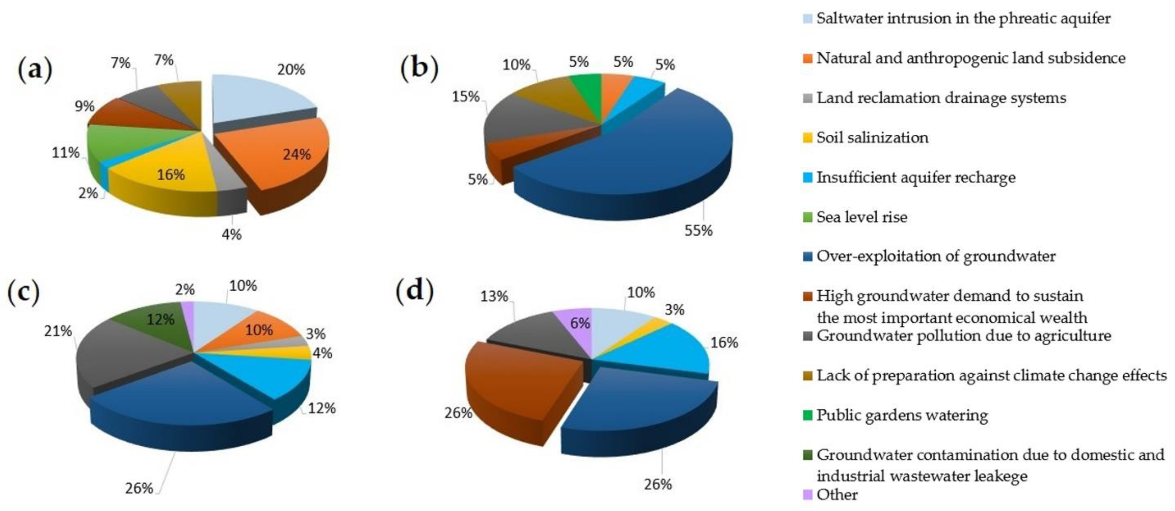
4.1. Main Issues Related to Groundwater Management
Different major concerns related to groundwater management (question N° 1,
Table 1) are evident in the analyzed pilot sites. The questionnaire answers highlight that the common main issue in all the pilot sites is aquifer over-exploitation, except for the Comacchio pilot site.
The two major concerns in the Italian study site are natural and anthropogenic land subsidence (24%) and saltwater intrusion in the phreatic aquifer (20%) (
Figure 8a).
At this site, another important issue is soil salinization (16%), as pointed out by the farmers. A total of 11% of the stakeholders reported the problem of sea-level rise, with the site localized in the proximity of the Adriatic coastline. The entities involved in monitoring groundwater resources highlighted the problem of loss of quality deterioration caused by the deep percolation of pollutants from agricultural areas, and the lack of preparation against climate changes effects (7%). It is worth noting that local authorities also reported the problem related to a high groundwater demand to sustain the economic development (9%). None of the respondents pointed out the problem of aquifer over-exploitation. It can be concluded that the coastal setting of the Italian pilot site explains the difference in the major concerns from the other sites.
In the Alto Guadalentín aquifer, 55% of stakeholders considered that the principal problem is groundwater over-exploitation. This is a consequence of the agricultural development that mainly occurred over the last decades of the 20th century [
47]. Secondly, 15% of stakeholders argued that groundwater pollution due to agriculture is an important issue at this site. Stakeholders also identified problems related to land subsidence (5%), insufficient aquifer recharge (5%), high groundwater demands to sustain the most important economic activity in the area (5%), lack of preparation against climate change (10%), and problems related to public gardens watering (5%) (
Figure 8b).
In the Gediz River basin, the majority of the participants (26%) answered that the predominant problem in their area is groundwater over-exploitation. Furthermore, 21% of the respondents considered groundwater pollution due to agricultural activities as a relevant problem for the basin. Insufficient aquifer recharge and groundwater pollution due to other reasons were viewed as significant problems (12% of selection each). Other causes of groundwater contamination are represented by industrial and/or domestic wastewater discharges and leakage from sewage conduits. In only one-tenth of the answers, land subsidence is of concern. It should be noted that, due to the large basin area, some of the stakeholders might not be directly affected by any of the suggested problems; in particular, land subsidence probably occurred on a local scale. Similarly, seawater intrusion in the phreatic coastal aquifer is viewed as a relevant problem by only 10% of the stakeholders, those located closer to the coast. Soil salinization, land reclamation drainage systems, and significant groundwater withdrawal to sustain economic activities were not considered important issues by the participants. A few stakeholders added other problems as relevant, e.g., urbanization, environmental impacts of industrial areas, and the absence of wastewater treatment plants or their intermittent operations. A summary of the answers to this question is shown in
Figure 8c.
Similarly, in the Azraq basin, the main issue is the over-exploitation of groundwater caused by the high groundwater demand to sustain the most important wealth source in the area (26% of the participants). Insufficient aquifer recharge and groundwater pollution due to agricultural activities were also considered as aspects of concern, according to 16% and 13% of the respondents, respectively. A value of 10% and 3% of the responses highlighted problems related to saltwater intrusion in the phreatic aquifer and soil salinization, respectively. The last groundwater issue selected by 6% of the participants is represented by the lack or inefficiency of water policies, management plans, and decision-making protocols (
Figure 8d).
4.2. Relevant Issues Related to Groundwater Management Tools
Concerning groundwater management tools (question N° 2,
Table 1) for all the study sites, the majority of the stakeholders considered the lack of managerial and planning instruments (e.g., land use and spatial planning, environmental impact assessment, groundwater protection zoning, the definition of responsibilities and roles of various groundwater resources management entities) as a relevant issue (
Figure 9).
Another relevant issue for the stakeholders interviewed in Italy, Spain and Jordan is related to the technical tools used for groundwater management, such as the availability of adequate surveying, groundwater level and quality monitoring and modelling, and other diagnostic analyses. In Turkey, a relevant issue for the respondents is the lack of utilization of economic tools (e.g., groundwater pricing, environmental taxes, tradable rights, and groundwater markets). It should be noted that groundwater pricing and tradable rights are not yet implemented in Turkey and Spain. The problems related to regulatory instruments (e.g., groundwater property and rights, well licensing and registering, drilling accreditation, water legislation) were viewed as important by 19% of the interviewees. Similarly, technical instruments were not of significant concern, with only 9% of the stakeholder votes. Furthermore, in Italy, 6% of the stakeholders recognized the lack of economic instruments, but none of them highlighted the regulatory instruments as a relevant issue.
The different perceptions of the relevant issues related to groundwater management tools may be partially influenced by the expertise levels of the stakeholders. In Italy, the majority of the stakeholders are local authorities responsible for water and land use management, and the results show that the dominant issues are related to the management and planning tools.
As far as the missing key information (question N° 3,
Table 1), in Italy, the stakeholders reported a lack of data for the water budget in the aquifer (22%) and groundwater extraction (17%). A total of 17% of the stakeholders expressed a lack of data about the effects of climate change and seawater intrusion. Among the stakeholders, the technicians reported a lack of data to monitor the change in groundwater storage (9%). A total of 6% of the stakeholders indicated missed data for the surface water supply and irrigation rates, land subsidence, and natural/artificial aquifer recharge. The stakeholder opinion about the monitoring system of groundwater level and quality shows that the acquired data are “neither adequate nor inadequate” both considering the frequency of the acquisitions and the spatial distribution of monitoring points (question N° 4,
Table 1). A higher percentage of stakeholders reported inadequate data about the spatial distribution of the water quality monitoring network. None of the respondents considered the monitoring of the groundwater level variation and water quality as very adequate, except for one respondent, who defined the frequency of the water quality monitoring as very adequate.
In Spain, the majority of interviewed stakeholders (45%) stated that the main missing information is the groundwater extraction rate. Unavailability of water quality was also reported by 10% of the interviewees. The stakeholder opinion about the adequacy of the groundwater monitoring network pointed out the inadequate spatial distribution of both groundwater level (50%) and quality (55%) monitoring points. However, the respondents mostly considered the monitoring frequency of the piezometric level (45%) to be adequate, but doubted the frequency of quality monitoring.
In Turkey, most of the stakeholders (69%) reported that accurate information about the volume of groundwater withdrawals is lacking or at least uncertain. Furthermore, about half of the stakeholders believe that there is great uncertainty about the information related to the total water consumption, changes in groundwater storage, and water budget interfering with the possibility of effective management of the groundwater resource. The lack of information about groundwater recharge is another issue that was identified as significant by 41% of the stakeholders. However, the recharge areas were perceived to be more certain by 28% of the stakeholders. Land subsidence (13%) and climate forecasts (16%) were perceived as uncertain processes, with a complete lack of information. It is interesting to note that one stakeholder mentioned the political influences as a challenge for effective groundwater management. The question about the adequacy of the existing monitoring networks in the GRB received a different response. Regarding groundwater level monitoring, the opinion was clearer, as 72% of all stakeholders considered the current monitoring frequency insufficient. Only 16% of them considered it as mostly adequate. The opinions expressed on the spatial coverage of piezometric monitoring are comparable. For example, 63% of the stakeholders considered it insufficient. Only 6% considered it mostly adequate and 16% as somewhat adequate. Concerning groundwater quality, the evaluation of the monitoring effort varies significantly. The frequency of groundwater sampling was considered adequate by 31% of the respondents, with most of them considering it as “somewhat adequate”. On the other hand, it was viewed as mostly inadequate and somewhat inadequate by 34% and 16% of all stakeholders, respectively, i.e., about half of the participants. A group of indecisive stakeholders, totaling 16%, considered the sampling frequency as “neither adequate nor inadequate”. In terms of the spatial coverage of groundwater quality monitoring, the general evaluation was negative. It was considered mostly inadequate or somewhat inadequate by 28% and 22% of the respondents, respectively. Only 10% of the stakeholders had the opinion that the spatial coverage of sampling is mostly adequate. In summary, the effort in monitoring the groundwater quality is regarded as more adequate than the effort for groundwater level monitoring (34% vs. 23%). The monitoring frequency is considered slightly less adequate than the spatial coverage (27% vs. 29%).
In Jordan, the major deficiency and uncertainty are related to the groundwater-dependent ecosystems (15% of the responses), water quality (13%), and climate forecasts (13%). Other categories with a moderate deficiency in data availability, including groundwater extraction, change in groundwater storage, water budget, sustainable yield, recharge areas, and recharge potential yield, were selected by 8% of the survey participants. A lack of data is less perceived in relation to groundwater levels (5%), surface water supply (3%), seawater intrusion (3%), and rechargeable surface water (3%). Regarding the coverage of the monitoring network of groundwater levels, the selections were equally distributed (20%) among the available five options (
Table 1). However, the geographic representation of groundwater level was evaluated as very inadequate by 40% of the respondents, with a lower ranking for the other options.
4.3. Main Issues Related to the Use of Flow and Land Subsidence Models for Groundwater Management
In relation to modelling (question N° 5,
Table 1), in Italy, 54% of the respondents filled in the form. The stakeholders pointed out that different models were previously used. In particular, MODFLOW was applied to simulate the groundwater flow in the deep aquifers and IRRINET was used in the shallow aquifer for irrigation purposes [
48]. The models were mainly used to estimate the water budget, perform land subsidence prediction, and develop long-term water planning (
Figure 10) (question N° 6,
Table 1).
In Spain, 90% of the stakeholders confirmed that they have a certain knowledge about numerical groundwater modelling. However, only 45% are aware that numerical models were already developed for the Alto Guadalentín aquifer [
20,
22]. Thus, most of them (46%) confirmed that modelling was used for long-term water planning. Alternative uses of groundwater modelling in the area are the calculation of water budgets (18%), planning groundwater extraction (9%), land subsidence prediction and planning (9%), environmental impact studies (9%), and research (9%) (
Figure 10).
In Turkey, most of the stakeholders (84%) confirmed that they know what a numerical model is. Furthermore, they were asked about their knowledge of any kind of groundwater flow model (i.e., analytical or numerical) developed for the Gediz River basin and the name of the model. The majority of stakeholders stated that they do not know if any flow model exists, 28% confirmed the presence of a model, and the remaining 16% are of the opinion that a model was never implemented. It is important to note that, in fact, a 2-D steady-state numerical groundwater flow model based on MODFLOW exists for the GRB [
49]. The last question in this section was about the purpose of applying a groundwater flow model. The results indicate that 31% of the respondents have no idea about the model’s purpose. Long-term water planning (20%), water budget (16%), recharge planning (14%), contaminant tracing (12%), groundwater extraction planning (4%) and land use planning (3%) were other uses that were selected by the respondents. Stakeholders did not recognize the model as useful for land subsidence prediction and planning, streamflow depletion, and environmental impact studies.
In Jordan, the stakeholders identified that groundwater models are primarily used for long-term water planning (22%), groundwater extraction planning (22%), environmental impact studies (16%), streamflow depletion (11%), contaminant tracing (10%), with a lower rank (6%) for land-use planning, water budget and recharge planning (
Figure 10).
Overall, stakeholder answers show that the models are viewed as a common tool for long-term water planning in the four Mediterranean areas. However, the models in all study sites are not being used for land use planning.
4.4. Stakeholder Interest in New Products for Groundwater Management
Question 7 (
Table 1) addresses the stakeholder interest in new products for groundwater management that will be developed during the RESERVOIR project.
In Italy, the results show that 62% of the interviewees are interested in the EO products (ground deformation maps, mapping of subsiding areas, and subsidence risk index) (
Figure 11). A total of 38% of them are interested in scenarios to detect the optimal timing and quantity of groundwater abstraction for irrigation purposes and in guidelines for groundwater resource management. In total, 31% of the respondents pointed out the importance of advanced EO-based geomechanical models to quantify aquifer storage and 23% the importance of methodologies for hydrogeological characterization using EO. A large part of the interviewees (67%) would like to be informed about the project activities (question N° 8,
Table 1), 42% to make the research results available to a broader audience, and 25% declared to be interested in staying up-to-date on concrete research developments. A total of 17% and 8% of the respondents are interested in participating in studies in the project and to define relevant questions and research gaps, respectively. In total, 58% and 42% of the respondents would like to be involved in the result dissemination and data collection (question N° 9,
Table 1). A total of 33% and 25% are interested in result interpretation and project plan development. A minor percentage (17%) is interested in data analysis. The majority of the stakeholders (58%) expressed their interest in regular workshops (question N° 10,
Table 1), 33% in regular project updates (e.g., through a newsletter) and digital materials (e.g., video conferences, shared documents, and folders, etc.). In total, 25% of the survey respondents are interested in annual meetings and personal dialogues with project researchers.
In Spain, question N° 7 (
Table 1) was not correctly processed in the questionnaire for this pilot site and no information can be extracted. However, regarding the remaining questions, the following conclusions were obtained. A total of 30% and 25% of the participants would like to be informed about the project activities and make research results available to a broader audience, respectively. In total, 25% of the participants are interested in staying up-to-date for concrete decision-making and 35% are interested in defining relevant questions and detecting research gaps. In relation to direct involvement, 55% of the interviewees showed a certain interest in being involved in data analysis and result interpretation. In total, 38% are interested in the development of the project plan, 33% in the result dissemination and 22% in the data collection. The main stakeholder preference for possible involvement in research was given to a regular update on the project (61%). A total of 55% of respondents indicated the use of digital tools, 33% an annual meeting, and 33% regular workshops. Finally, 22% of survey respondents would be interested in fieldwork participation and 16% would prefer individual discussions.
In Turkey, most of the topics addressed by RESERVOIR were of interest to the majority of the stakeholders. The development of scenarios to detect the optimum timing and amount of groundwater withdrawal for irrigation was the most selected topic, with 24% of the stakeholder votes (
Figure 11). It was followed by the topic of advanced EO-based geomechanical modelling to quantify aquifer storage and production of EO-based land deformation maps and land subsidence maps (20% each).
In Jordan, the guidelines to properly manage the groundwater resource were the most important topic selected by 60% of the participants. Earth observation (EO) products and analyses aimed at detecting the optimal timing and quantity of groundwater abstraction for irrigation purposes and wetland protection were selected by 54% of the interviewees. A total of 46% of the participants selected the methodology for hydrogeological characterisation using EO and advanced EO-based geomechanical model to quantify the aquifer storage as key topics (
Figure 11).
Therefore, the results show that the stakeholders are very interested in the development of guidelines and the EO products as a new supporting tool for groundwater resource management.
5. Discussion
The participatory processes employed in this study are the first important steps to improving sustainable groundwater management in water-stressed Mediterranean basins. The engagement of stakeholders provides useful knowledge to further plan the research activities on aquifer management.
The approach gives insights into the actual risks related to the four study sites.
Different perspectives from groups with various roles, backgrounds, and knowledge were considered. The questionnaire-based approach has allowed for the inclusion of individuals from a large range of socio-economic, demographic and professional experience backgrounds that have shared their views with anonymity.
A previous study shows key findings of a survey developed by the Organisation for Economic Co-operation and Development (OECD) that includes the stakeholder views in 69 worldwide case studies [
46]. This work used a questionnaire-based approach to assess the impact of stakeholder engagement in water-related decision-making and policy implementation. The results show that, for the respondents, one of the main obstacles to groundwater management is the lack of political will and leadership. Other relevant issues are related to the lack of clarity on the use of stakeholder inputs, the institutional fragmentation and the lack of fundings [
46].
Unfortunately, similar previous studies about any of the four study sites are not known to provide additional comparative analyses. According to the authors’ knowledge, this study is the first survey of stakeholder perceptions and opinions about groundwater management in these regions.
The stakeholder priorities on the aquifer management offer the opportunity to outline some common and current challenges in the Mediterranean area, which are discussed next.
5.1. Priorities in the Four Water-Stressed Mediterranean Areas
The identified priorities are dependent on the geographical setting and socio-economic status of each area. Therefore, the priorities differ among the study sites and among the stakeholder groups.
The stakeholder groups have a specific geographic focus. In the case of the respondent from a national authority, they may be sharing point of views that are related to issues concerning the whole country, rather than the local study site. Indeed, the results show that all the sites are afflicted by different issues (
Figure 8).
In the Comacchio coastal aquifer, the main problems identified by the stakeholders are the natural and human-induced land subsidence and the seawater intrusion of the phreatic aquifer that affects agricultural activities. Saltwater intrusion causes a deterioration of the subsurface water quality, which prevents the use of groundwater resources for irrigation by farmers. Therefore, there is a demand to deeply understand the interaction between freshwater and saltwater. The problem of land subsidence is mainly identified by some municipalities along the coastline. In particular, the Goro-Gorino Municipality reports damages and less efficiency along the quayside due to land subsidence.
Although the main problem identified by the stakeholders of the Alto Guadalentín basin is aquifer over-exploitation, groundwater contamination is equally important. It is worth noting that, at this site, an unusual phenomenon of groundwater intrusion from deep to shallower aquifers caused by the lowering of the piezometric level was observed [
21]. On the other hand, nitrate contamination, which is of greatest importance under EU guidelines, should be minimized with mitigation measures (e.g., reduction in water use for irrigation). The countermeasures adopted in the past did not suffice to reverse the state of heavy overexploitation of the aquifer, and new management strategies should be implemented in the next water management plan. Furthermore, the stakeholders have not identified land subsidence as a priority, although this is the area exhibiting the highest subsidence rate in Europe. This is probably because in this site, the land subsidence does not produce differential settlements that could cause building and infrastructure damages.
Many issues concerning groundwater management were brought to attention by the stakeholders in the GRB. Two of these problems were pronounced, which are the over-exploitation of groundwater and the deterioration of its quality because of agriculture. Despite the problem identification, the stakeholders believe that currently, no action plan can realistically resolve these issues. The key missing information is data about groundwater pumping, with the added uncertainty of groundwater use from numerous unregistered irrigation wells. Furthermore, it is interesting to note that there seems to be a lack of awareness about the availability of a groundwater flow model for this aquifer. Although there are different opinions by the stakeholders on the modelling purpose and use, they are uncertain whether this model is actively used by the responsible water authority. Conversations with technical staff working at the water authority institution revealed that the model was not used in decision-making or analysis of the groundwater system in recent years. Perhaps the model presently available is perceived as inadequate to be used as an effective tool; therefore, an improvement and further modelling development may be due.
In the Azraq basin, the key groundwater challenges according to the stakeholders are the over-exploitation coupled with the increasing groundwater demand to sustain agriculture, which is the most important economic activity in the region. The groundwater problems are aggravated by insufficient aquifer recharge and the contamination caused by agricultural activities. Another key issue highlighted by the stakeholders is the missing and uncertainty in the groundwater management data, which will adversely affect the decision-making process. Several data categories were identified, demonstrating that significant improvements are needed in the field of monitoring and management, such as groundwater-dependent ecosystems, water quality, and climate forecasts. It is clear that sustainable solutions in the water supply sector are considered necessary in Jordan to reduce aquifer overexploitation, which will ultimately alleviate other challenges, such as groundwater salinization. The lack of adequate spatio-temporal monitoring of groundwater can be an obstacle to the effectiveness of policy-making and groundwater management. The future development of groundwater policies and laws should take into account existing knowledge about groundwater systems. Therefore, gathering monitoring data about groundwater resources plays an important role in effective groundwater management [
46].
5.2. Common Challenges
Common challenges were identified, which are global in nature and are not specific. Five common ongoing challenges related to groundwater management emerged from the stakeholder feedback, which are as follows:
Developing a long-term program of monitoring activities to generate knowledge about the groundwater status. This program should consider both the current and future needs, as well as the available economic resources to develop the program. Among others, the information generated should include basic information about the number, location, and extraction rates of all existing wells, as well as the hydrochemical characteristics of the extracted water. Without this information, groundwater management will consist of a blind task with uncertain consequences.
Definition of benchmarks for evaluating the adequacy of the groundwater monitoring network, both considering the frequency of data acquisition and the spatial distribution.
Development and periodic updating of groundwater flow models as a supporting management tool.
Formulating appropriate management scenarios by considering the transient state of the aquifer to support decision-making on groundwater exploitation.
Development of a tool to disseminate model results and make them accessible, free of charge, even interactive, and easy to use. Dissemination campaigns to raise awareness should be planned.
6. Conclusions
Close collaboration between the scientific community and the water managers is important for enabling the direct transfer of knowledge gained from research to the management practice.
The main issue in the selected study sites is aquifer over-exploitation, except for the Italian coastal aquifer in Comacchio. Other important issues are groundwater pollution due to the agricultural activities and the high groundwater demand to sustain the most important economic activities. For the Comacchio coastal aquifer, the main environmental problems are the saltwater intrusion in the phreatic aquifer and natural and anthropogenic land subsidence.
The stakeholder knowledge about the use of numerical models for groundwater management is restricted to application for long-term planning and water budget.
From the stakeholder perspective, the groundwater monitoring systems in the study areas are inadequate. The results highlight the need to introduce and define parameters to evaluate the appropriateness of groundwater monitoring systems, by considering both the spatial and temporal distribution of the measurements and groundwater withdrawals.
Gathering data about groundwater resources has a relevant role in effective groundwater management and in the development of groundwater policies and laws. This should be a priority for these water-stressed Mediterranean areas.
Within the framework of the RESERVOIR project, the overall objective is to address the issues raised by the stakeholders through the implementation of effective strategies and include their perspectives in future activities.


 ,
, 


