
Multi-Time Scale Analysis of Urbanization in Urban Thermal Environment in Major Function-Oriented Zones at Landsat-Scale: A Case Study of Hefei City, China


Abstract
:1. Introduction
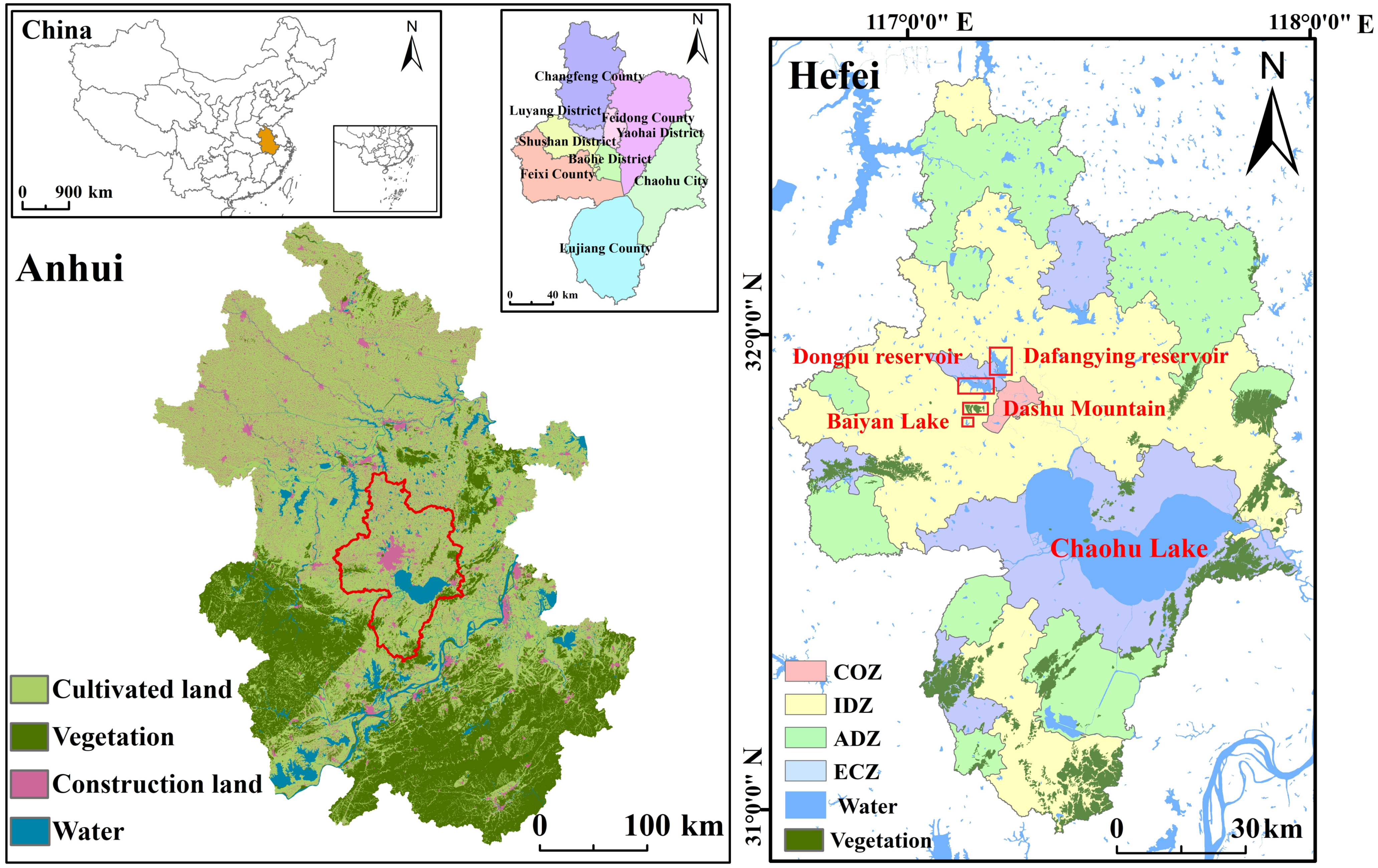
2. Study Area
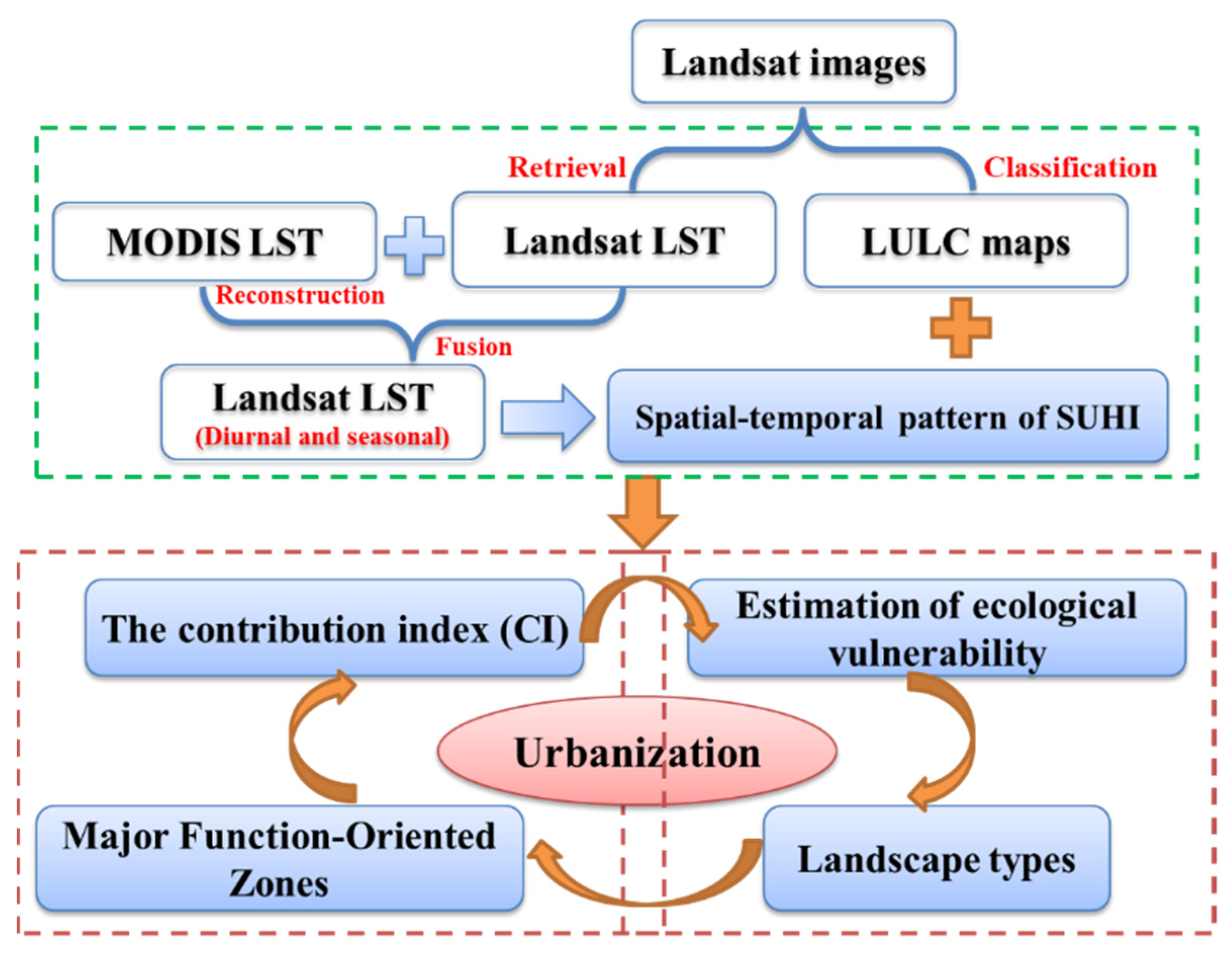
3. Materials and Methods
3.1. Satellite Data Acquisition and Pre-Processing
3.2. Intensity of Surface Urban Heat Island
3.3. The Contribution Index (CI) of MFOZ
3.4. The Urban Thermal Field Variation Index
4. Results and Analysis
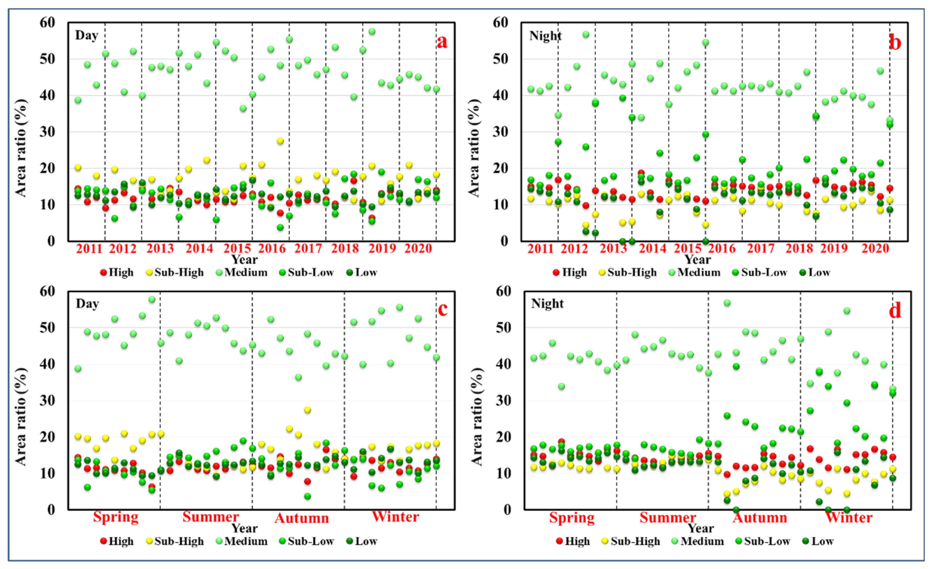
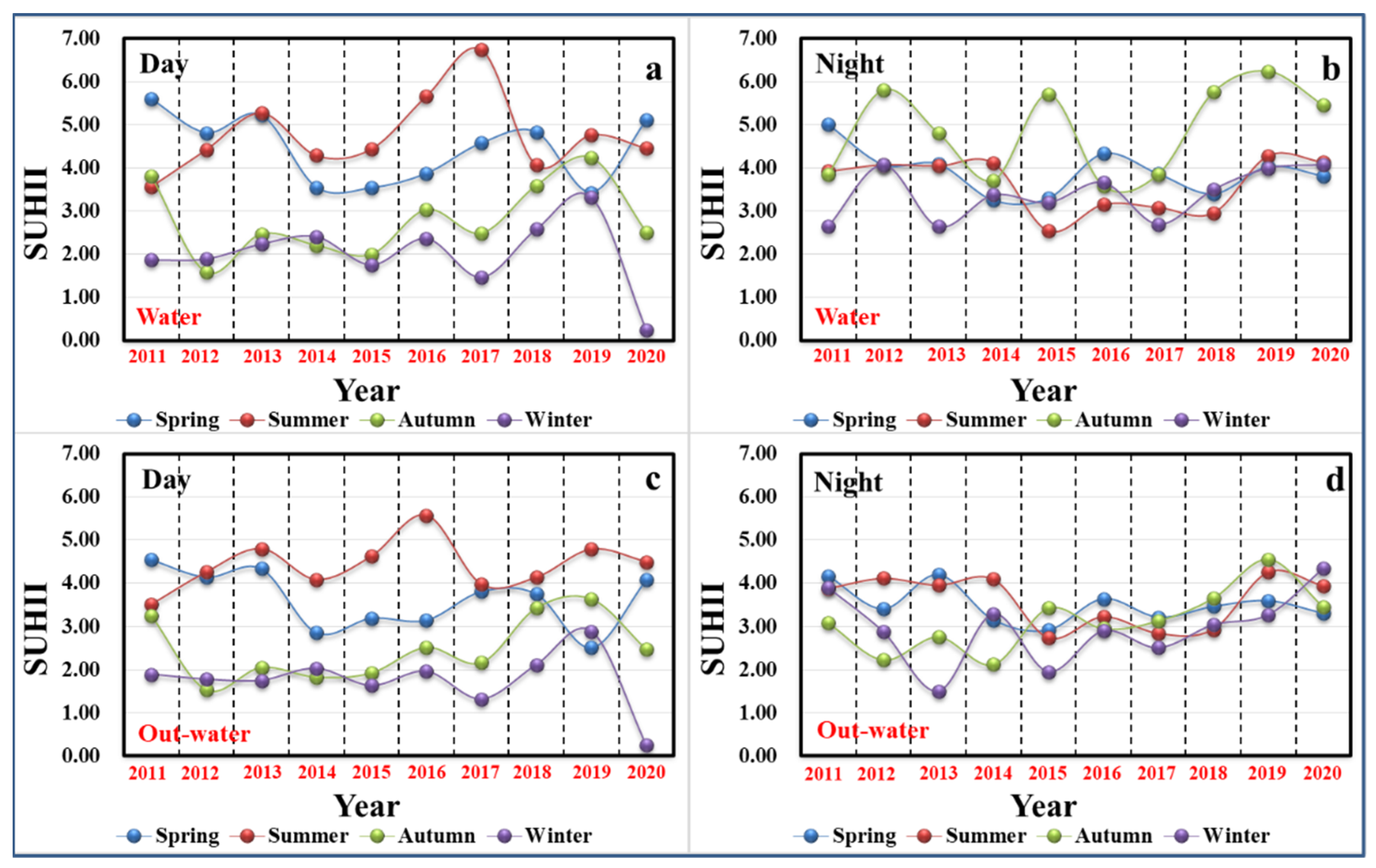
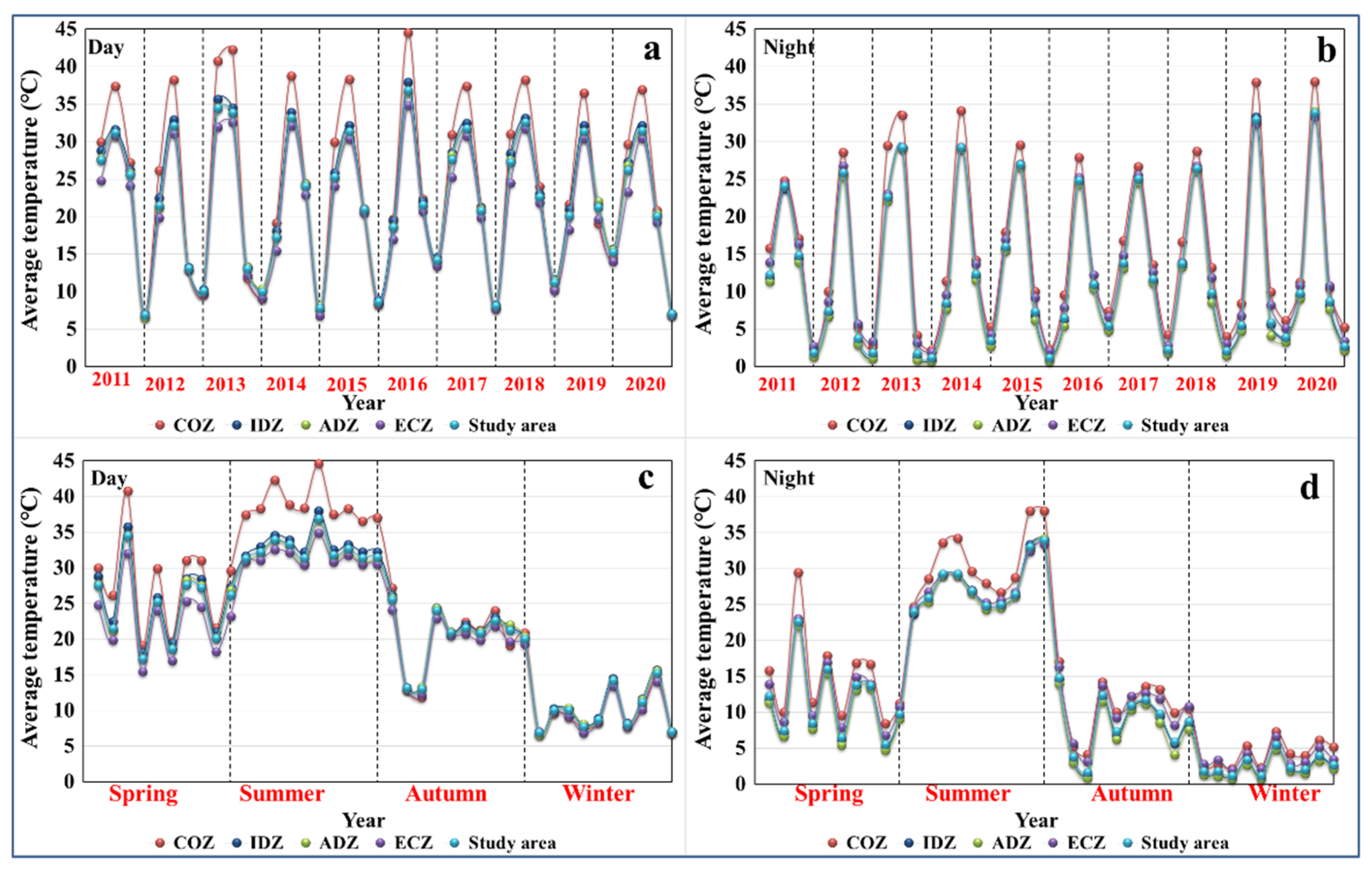
4.1. Evolution Analysis of Diurnal and Seasonal SUHI
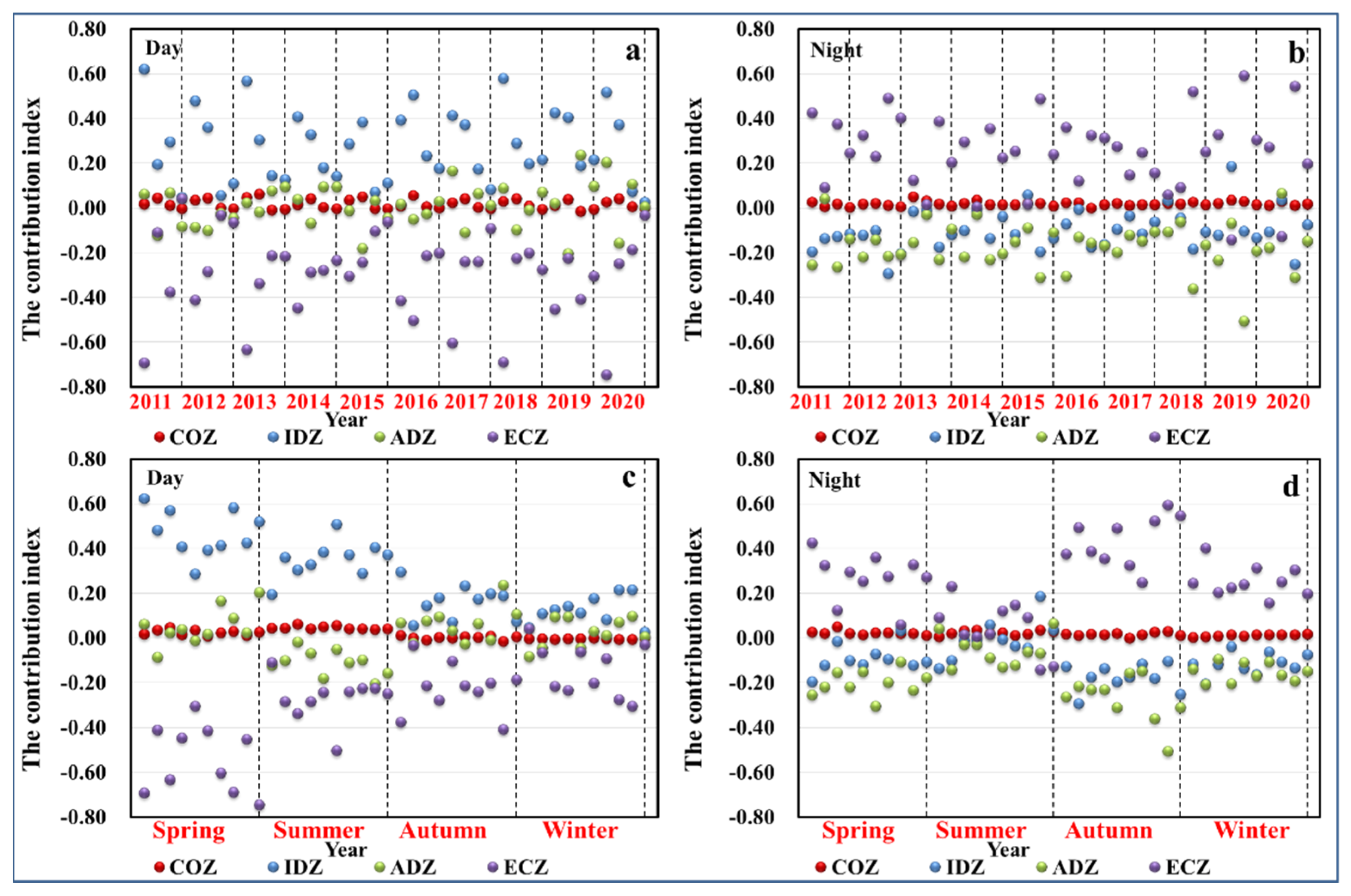
4.2. Diurnal and Seasonal Contribution of MFOZ
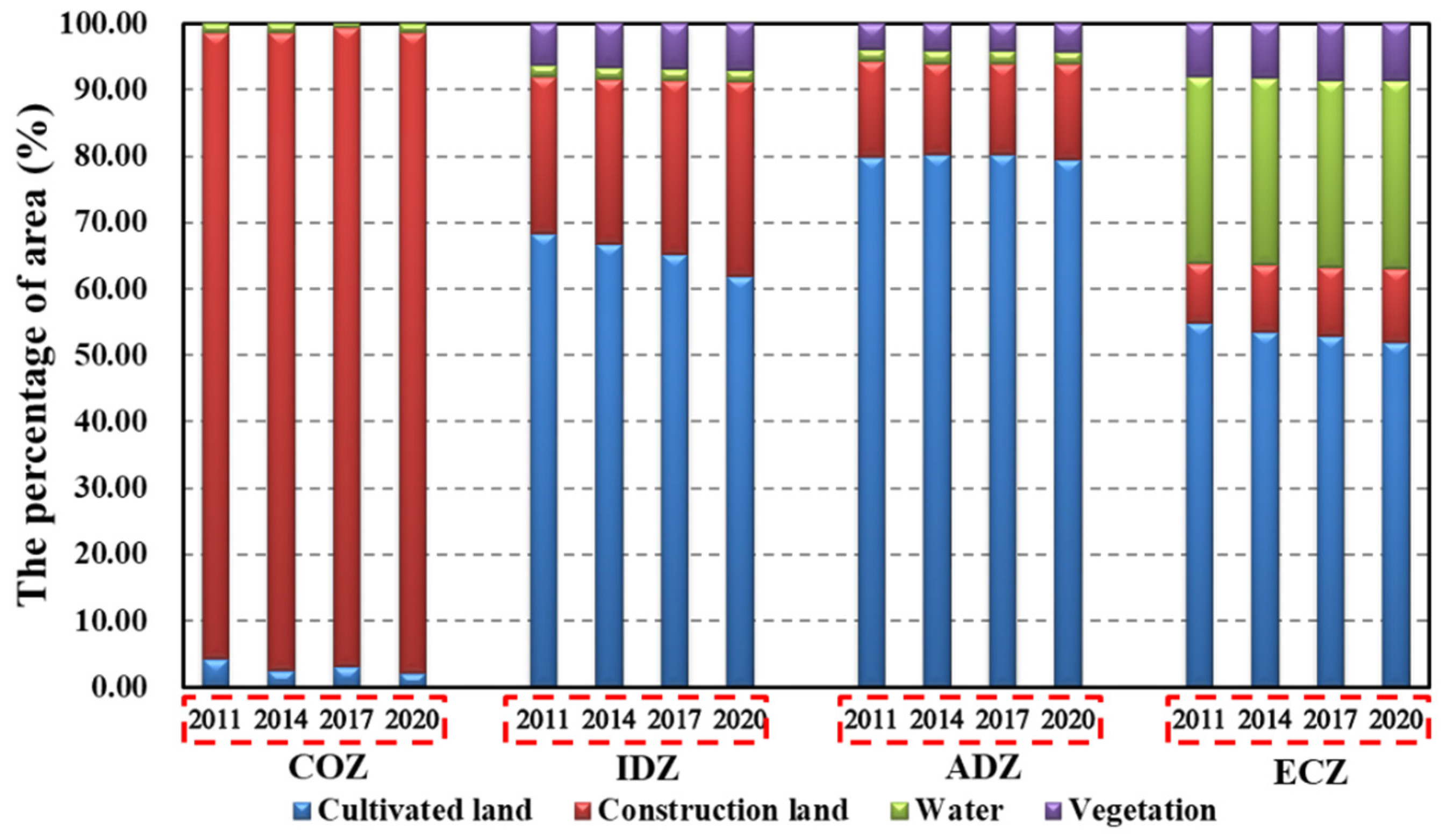
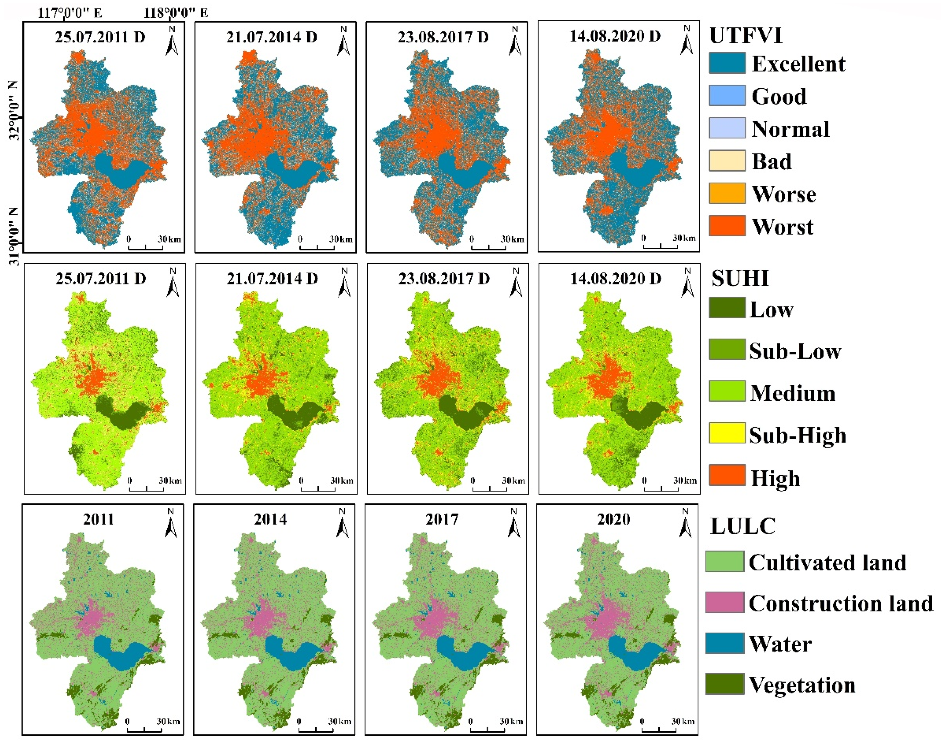
4.3. Contribution of Landscape Types under MFOZ
4.4. Estimation of UTFVI
5. Discussion
6. Conclusions
Author Contributions
Funding
Institutional Review Board Statement
Informed Consent Statement
Data Availability Statement
Acknowledgments
Conflicts of Interest
References
- Xia, H.; Zhang, W.; He, L.; Ma, M.; Wang, X. Assessment on china’s urbanization after the implementation of main functional areas planning. J. Environ. Manag. 2020, 264, 110381. [Google Scholar] [CrossRef] [PubMed]
- Lu, Y.; Coops, N.C.; Hermosilla, T. Estimating urban vegetation fraction across 25 cities in pan-Pacific using Landsat time series data. ISPRS J. Photogramm. Remote Sens. 2017, 126, 11–23. [Google Scholar] [CrossRef]
- Gx, A.; Hua, S.B.; Qiang, Z.B.; Ra, A.; Kg, C.; Zw, D. Monitoring and characterizing multi-decadal variations of urban thermal condition using time-series thermal remote sensing and dynamic land cover data. Remote Sens. Environ. 2021, 269, 112803. [Google Scholar]
- Arnfield, A.J. Two decades of urban climate research: A review of turbulence, exchanges of energy and water, and the urban heat island. Int. J. Clim. 2003, 23, 1–26. [Google Scholar] [CrossRef]
- Howard, L. The Climate of London; London, UK, 1833; Volume I–III, Available online: https://books.google.com.hk/books/about/The_Climate_of_London.html?id=L0g0AQAAMAAJ&redir_esc=y (accessed on 28 March 2022).
- Weng, Q.; Lu, D.; Schubring, J. Estimation of land surface temperature–vegetation abundance relationship for urban heat island studies. Remote Sens. Environ. 2004, 89, 467–483. [Google Scholar] [CrossRef]
- Yusuf, Y.A.; Pradhan, B.; Idrees, M.O. Spatio-temporal Assessment of Urban Heat Island Effects in Kuala Lumpur Metropolitan City Using Landsat Images. J. Indian Soc. Remote Sens. 2014, 42, 829–837. [Google Scholar] [CrossRef]
- Ogashawara, I.; Bastos, V.D.B. A Quantitative Approach for Analyzing the Relationship between Urban Heat Islands and Land Cover. Remote Sens. 2012, 4, 3596–3618. [Google Scholar] [CrossRef] [Green Version]
- Peng, J.; Jia, J.; Liu, Y.; Li, H.; Wu, J. Seasonal contrast of the dominant factors for spatial distribution of land surface temperature in urban areas. Remote Sens. Environ. 2018, 215, 255–267. [Google Scholar] [CrossRef]
- Zhan, W.; Ju, W.; Hai, S.; Ferguson, G.; Quan, J.; Tang, C.; Guo, Z.; Kong, F. Satellite-Derived Subsurface Urban Heat Island. Environ. Sci. Technol. 2014, 48, 12134–12140. [Google Scholar] [CrossRef]
- Wang, Y.; Ren, Y.; Song, L.; Xiang, Y. Responses of extreme high temperatures to urbanization in the Beijing–Tianjin–Hebei urban agglomeration in the context of a changing climate. Meteorol. Appl. 2021, 28, e2024. [Google Scholar] [CrossRef]
- Stewart, I.D. A systematic review and scientific critique of methodology in modern urban heat island literature. Int. J. Clim. 2011, 31, 200–217. [Google Scholar] [CrossRef]
- Chakraborty, T.; Lee, X.; Ermida, S.L.; Zhan, W. On the land emissivity assumption and Landsat-derived surface urban heat islands: A global analysis. Remote Sens. Environ. 2021, 265, 112682. [Google Scholar] [CrossRef]
- Wu, P.; Yin, Z.; Zeng, C.; Duan, S.-B.; Gottsche, F.-M.; Li, X.; Ma, X.; Yang, H.; Shen, H. Spatially Continuous and High-Resolution Land Surface Temperature Product Generation: A review of reconstruction and spatiotemporal fusion techniques. IEEE Geosci. Remote Sens. Mag. 2021, 9, 112–137. [Google Scholar] [CrossRef]
- Li, Z.; Tang, B.; Wu, H.; Ren, H.; Yan, G.; Wan, Z.; Trigo, I.F.; Sobrino, J.A. Satellite-derived land surface temperature: Current status and perspectives. Remote Sens. Environ. 2013, 131, 14–37. [Google Scholar] [CrossRef] [Green Version]
- Zhou, D.; Xiao, J.; Bonafoni, S.; Berger, C.; Deilami, K.; Zhou, Y.; Frolking, S.; Yao, R.; Qiao, Z.; Sobrino, J. Satellite Remote Sensing of Surface Urban Heat Islands: Progress, Challenges, and Perspectives. Remote Sens. 2019, 11, 48. [Google Scholar] [CrossRef] [Green Version]
- Li, X.; Li, W.; Middel, A.; Harlan, S.L.; Brazel, A.J.; Turner II, B.L. Remote sensing of the surface urban heat island and land architecture in Phoenix, Arizona: Combined effects of land composition and configuration and cadastral–demographic–economic factors. Remote Sens. Environ. 2016, 174, 233–243. [Google Scholar] [CrossRef] [Green Version]
- Streutker, D.R. A remote sensing study of the urban heat island of Houston, Texas. Int. J. Remote Sens. 2002, 23, 2595–2608. [Google Scholar] [CrossRef]
- Unger, J. Intra-urban relationship between surface geometry and urban heat island: Review and new approach. Clim. Res. 2004, 27, 253–264. [Google Scholar] [CrossRef] [Green Version]
- Chow, W.T.L.; Chuang, W.; Gober, P. Vulnerability to Extreme Heat in Metropolitan Phoenix: Spatial, Temporal, and Demographic Dimensions. Prof. Geogr. 2012, 64, 286–302. [Google Scholar] [CrossRef]
- Nichol, J.E. High-Resolution Surface Temperature Patterns Related to Urban Morphology in a Tropical City: A Satellite-Based Study. J. Appl. Meteorol. 1996, 35, 135–146. [Google Scholar] [CrossRef] [Green Version]
- Carmona, P.L.; Tran, D.X.; Pla, F.; Myint, S.W.; Kieu, H.V. Characterizing the relationship between land use land cover change and land surface temperature. ISPRS J. Photogramm. Remote Sens. 2017, 124, 119–132. [Google Scholar] [CrossRef] [Green Version]
- Anniballe, R.; Bonafoni, S.; Pichierri, M. Spatial and temporal trends of the surface and air heat island over Milan using MODIS data. Remote Sens. Environ. 2014, 150, 163–171. [Google Scholar] [CrossRef]
- Liu, H.; Huang, B.; Gao, S.; Wang, J.; Yang, C.; Li, R. Impacts of the evolving urban development on intra-urban surface thermal environment: Evidence from 323 Chinese cities. Sci. Total Environ. 2021, 771, 144810. [Google Scholar] [CrossRef]
- Estoque, R.C.; Murayama, Y. Monitoring surface urban heat island formation in a tropical mountain city using Landsat data (1987–2015). ISPRS J. Photogramm. Remote Sens. 2017, 133, 18–29. [Google Scholar] [CrossRef]
- Hong, J.W.; Hong, J.; Kwon, E.E.; Yoon, D.K. Temporal dynamics of urban heat island correlated with the socio-economic development over the past half-century in Seoul, Korea. Environ. Pollut. 2019, 254, 112934. [Google Scholar] [CrossRef]
- Unger, J.; Sümeghy, Z.; Gulyás, Á.; Zsolt, B.; Mucsi, L. Land-use and meteorological aspects of the urban heat island. Meteorol. Appl. 2010, 8, 189–194. [Google Scholar] [CrossRef] [Green Version]
- Connors, J.P.; Galletti, C.S.; Chow, W.T.L. Landscape configuration and urban heat island effects: Assessing the relationship between landscape characteristics and land surface temperature in Phoenix, Arizona. Landsc. Ecol. 2013, 28, 271–283. [Google Scholar] [CrossRef]
- Li, X.; Zhou, W.; Quyang, W.; Zheng, H. Spatial pattern of green space affects land surface temperature: Evidence from the heavily urbanized Beijing metropolitan area China. Landsc. Ecol. 2012, 27, 887–898. [Google Scholar] [CrossRef]
- Turner, B.L.; Janetos, A.C., II; Verburg, P.H.; Murray, A.T. Land system architecture: Using land systems to adapt and mitigate global environmental change. Glob. Environ. Change 2013, 23, 395–397. [Google Scholar] [CrossRef]
- Xia, H.; Chen, Y.; Song, C.; Li, J.; Quan, J.; Zhou, G. Analysis of surface urban heat islands based on local climate zones via spatiotemporally enhanced land surface temperature. Remote Sens. Environ. 2022, 273, 112972. [Google Scholar] [CrossRef]
- Huang, X.; Wang, Y. Investigating the effects of 3D urban morphology on the surface urban heat island effect in urban functional zones by using high-resolution remote sensing data: A case study of Wuhan, Central China. ISPRS J. Photogramm. Remote Sens. 2019, 152, 119–131. [Google Scholar] [CrossRef]
- Feyisa, G.L.; Meilby, H.; Jenerette, G.D.; Pauleit, S. Locally optimized separability enhancement indices for urban land cover mapping: Exploring thermal environmental consequences of rapid urbanization in Addis Ababa, Ethiopia. Remote Sens. Environ. 2016, 175, 14–31. [Google Scholar] [CrossRef]
- Zhao, L.; Li, X.; Chai, X. Influencing Factors and Quality Evaluation of Urban Thermal Environment Based on Artificial Neural Network. Int. J. Heat Technol. 2021, 39, 128–136. [Google Scholar] [CrossRef]
- Ye, H.; Li, Z.; Zhang, N.; Leng, X.; Meng, D.; Zheng, J.; Li, Y. Variations in the Effects of Landscape Patterns on the Urban Thermal Environment during Rapid Urbanization (1990–2020) in Megacities. Remote Sens. 2021, 13, 3415. [Google Scholar] [CrossRef]
- Yin, Z.; Wu, P.; Foody, G.M.; Wu, Y.; Liu, Z.; Du, Y.; Ling, F. Spatiotemporal Fusion of Land Surface Temperature Based on a Convolutional Neural Network. IEEE Trans. Geosci. Remote. Sens. 2020, 99, 1–15. [Google Scholar] [CrossRef]
- Wu, P.; Shen, H.; Zhang, L.; Göttsche, F.-M. Integrated fusion of multi-scale polar-orbiting and geostationary satellite observations for the mapping of high spatial and temporal resolution land surface temperature. Remote Sens. Environ. 2015, 156, 169–181. [Google Scholar] [CrossRef]
- Xu, S. An approach to analyzing the intensity of the daytime surface urban heat island effect at a local scale. Environ. Monit. Assess. 2008, 151, 289–300. [Google Scholar] [CrossRef]
- Zhi, Q.; Tian, G.; Lin, X. Diurnal and seasonal impacts of urbanization on the urban thermal environment: A case study of Beijing using MODIS data. ISPRS J. Photogramm. Remote Sens. 2013, 85, 93–101. [Google Scholar]
- Coutts, A.M.; Harris, R.J.; Phan, T.; Livesley, S.J.; Williams, N.; Tapper, N.J. Thermal infrared remote sensing of urban heat: Hotspots, vegetation, and an assessment of techniques for use in urban planning. Remote Sens. Environ. 2016, 186, 637–651. [Google Scholar] [CrossRef]
- Lu, Y.; Wu, P.; Ma, X.; Yang, H.; Wu, Y. Monitoring Seasonal and Diurnal Surface Urban Heat Islands Variations Using Landsat-Scale Data in Hefei, China, 2000–2017. IEEE J. Sel. Top. Appl. Earth Obs. Remote Sens. 2020, 13, 6410–6423. [Google Scholar] [CrossRef]
- Lee, C.H.; Zhao, J.L.; Hassna, G. Government-incentivized crowd funding for one-belt, one-road enterprises: Design and research issues. Financ. Innov. 2016, 2, 2. [Google Scholar] [CrossRef] [Green Version]
- Jin, G.; Deng, X.; Zhao, X.; Guo, B.; Yang, J. Spatiotemporal patterns in urbanization efficiency within the Yangtze River Economic Belt between 2005 and 2014. J. Geogr. ENCES 2018, 28, 1113–1126. [Google Scholar] [CrossRef] [Green Version]
- Yu, X.; Guo, X.; Wu, Z. Land surface temperature retrieval from Landsat 8 TIRS-Comparison between radiative transfer equation-based method, split window algorithm and single channel method. Remote Sens. 2014, 6, 9829–9852. [Google Scholar] [CrossRef] [Green Version]
- Qin, Z.H.; Li, W.J.; Zhang, M.H.; Karnieli, A.; Berliner, P. Mono-window algorithm for retrieving land surface temperature from Landsat TM6 data. Acta Geogr. Sin. 2001, 68, 456–466. [Google Scholar]
- Quan, J.; Chen, Y.; Zhan, W.; Wang, J.; Voogt, J.; Wang, M. Multi-temporal trajectory of the urban heat island centroid in Beijing, China based on a Gaussian volume model. Remote Sens. Environ. 2014, 149, 33–46. [Google Scholar] [CrossRef]
- Firozjaei, M.K.; Kiavarz, M.; Alavipanah, S.K.; Lakes, T.; Qureshi, S. Monitoring and forecasting heat island intensity through multi-temporal image analysis and cellular automata-Markov chain modelling: A case of Babol city, Iran. Ecol. Indic. 2018, 91, 155–170. [Google Scholar] [CrossRef]
- Bao, T.; Li, X.; Zhang, J.; Zhang, Y.; Tian, S. Assessing the Distribution of Urban Green Spaces and its Anisotropic Cooling Distance on Urban Heat Island Pattern in Baotou, China. ISPRS Int. J. Geo-Inf. 2016, 5, 12. [Google Scholar] [CrossRef]
- Yao, Y.; Chen, X.; Qian, J.; Felix, N. Seasonal variations of the urban thermal environment effect in a tropical coastal city. Adv. Meteorol. 2017, 1, 1–18. [Google Scholar]
- Sun, R.; Xie, W.; Chen, L. A landscape connectivity model to quantify contributions of heat sources and sinks in urban regions. Landsc. Urban Plan. 2018, 178, 43–50. [Google Scholar] [CrossRef]
- Zhang, Y.; Yu, T.; Gu, X. Land surface temperature retrieval from cbers-02 IRMSS thermal infrared data and its applications in quantitative analysis of urban heat island effect. J. Remote Sens. 2006, 10, 789–797. [Google Scholar]
- Mnhna, B.; Aakc, D. Assessment of urban thermal field variance index and defining the relationship between land cover and surface temperature in Chattogram city: A remote sensing and statistical approach-Science Direct. Environ. Chall. 2021, 4, 100107. [Google Scholar]
- Majumder, A.; Setia, R.; Kingra, P.K.; Sembhi, H.; Singh, S.P.; Pateriya, B. Estimation of land surface temperature using different retrieval methods for studying the spatiotemporal variations of surface urban heat and cold islands in Indian Punjab. Environ. Dev. Sustain. 2021, 23, 15921–15942. [Google Scholar] [CrossRef]
- Peng, J.; Ma, J.; Liu, Q.; Liu, Y.; Hu, Y.; Li, Y.; Yue, Y. Spatial-temporal change of land surface temperature across 285 cities in China: An urban-rural contrast perspective. Sci. Total Environ. 2018, 635, 487–497. [Google Scholar] [CrossRef]
- Wang, C.; Myint, S.W.; Wang, Z.; Song, J. Spatio-Temporal Modeling of the Urban Heat Island in the Phoenix Metropolitan Area: Land Use Change Implications. Remote Sens. 2016, 8, 185. [Google Scholar] [CrossRef] [Green Version]
- Zhou, D.; Zhao, S.; Liu, S.; Zhang, L. Spatiotemporal trends of terrestrial vegetation activity along the urban development intensity gradient in china’s 32 major cities. Sci. Total Environ. 2014, 488–489, 136–145. [Google Scholar] [CrossRef]
- Yonaba, R.; Koïta, M.; Mounirou, L.A.; Tazen, F.; Queloz, P.; Biaou, A.; Niang, D.; Zouré, C.; Karambiri, H.; Yacouba, H. Spatial and transient modelling of land use/land cover (LULC) dynamics in a Sahelian landscape under semi-arid climate in northern Burkina Faso. Land Use Policy 2021, 103, 105305. [Google Scholar] [CrossRef]
- Gupta, Srimanta. Land Use/Land Cover classification of an urban area—A case study of Burdwan Municipality, India. Int. J. Geomat. Geosci. 2012, 2, 1014–1026. [Google Scholar]
- Ramaiah, M.; Avtar, R.; Rahman, M.M. Land Cover Influences on LST in Two Proposed Smart Cities of India: Comparative Analysis Using Spectral Indices. Land 2020, 9, 292. [Google Scholar] [CrossRef]
- Yin, C.; Yuan, M.; Lu, Y.; Huang, Y.; Liu, Y. Effects of urban form on the urban heat island effect based on spatial regression model. Sci. Total Environ. 2018, 634, 696–704. [Google Scholar] [CrossRef]
- Stewart, I.; Oke, T. Thermal differentiation of local climate zones using temperature observations from urban and rural field sites. In Proceedings of the Ninth Symposium on the Urban Environment, Keystone, CO, USA, 2–6 August 2010. [Google Scholar]
- Chen, X.; Xu, Y.; Yang, J.; Wu, Z.; Zhu, H. Remote sensing of urban thermal environments within local climate zones: A case study of two high-density subtropical Chinese cities—ScienceDirect. Urban Clim. 2020, 31, 100568. [Google Scholar] [CrossRef]
- Mariani, L.; Parisi, S.G.; Cola, G.; Lafortezza, R.; Colangelo, G.; Sanesi, G. Climatological analysis of the mitigating effect of vegetation on the urban heat island of Milan, Italy. Sci. Total Environ. 2016, 569–570, 762–773. [Google Scholar] [CrossRef] [PubMed]
- Peng, J.; Dan, Y.; Qiao, R.; Liu, Y.; Dong, J.; Wu, J. How to quantify the cooling effect of urban parks? Linking maximum and accumulation perspectives. Remote Sens. Environ. 2020, 252, 112135. [Google Scholar] [CrossRef]
- Algretawee, H.; Rayburg, S.; Neave, M. Estimating the effect of park proximity to the central of Melbourne city on Urban Heat Island (UHI) relative to Land Surface Temperature (LST). Ecol. Eng. 2019, 138, 374–390. [Google Scholar] [CrossRef]


| Data | Dates | |||||||
|---|---|---|---|---|---|---|---|---|
| Landsat-5 | 23 April 2011 | |||||||
| Landsat-7 | 8 October 2011 | 11 December 2011 | 1 April 2012 | 11 November 2012 | 30 November 2013 | 17 January 2014 | 5 February 2015 | 12 May 2015 |
| 6 November 2016 | 8 December 2016 | 11 October 2018 | 15 November 2019 | |||||
| Landsat-8 | 14 May 2013 | 14 March 2014 | 24 October 2014 | 27 October 2015 | 15 January 2016 | 27 March 2016 | 25 July 2016 | 23 April 2017 |
| 1 November 2017 | 19 December 2017 | 10 April 2018 | 23 January 2019 | 12 March 2019 | 15 April 2020 | 24 October 2020 | 12 January 2021 | |
| MODIS | 23 April 2011 | 29 July 2011 | 8 October 2011 | 11 December 2011 | 1 April 2012 | 31 July 2012 | 11 November 2012 | 4 December 2012 |
| 14 May 2013 | 13 July 2013 | 30 November 2013 | 17 January 2014 | 14 March 2014 | 21 July 2014 | 24 October 2014 | 5 February 2015 | |
| 12 May 2015 | 4 August 2015 | 27 October 2015 | 15 January 2016 | 27 March 2016 | 25 July 2016 | 6 November 2016 | 8 December 2016 | |
| 23 April 2017 | 23 August 2017 | 1 November 2017 | 19 December 2017 | 10 April 2018 | 14 July 2018 | 11 October 2018 | 23 January 2019 | |
| 12 March 2019 | 13 August 2019 | 15 November 2019 | 22 February 2020 | 15 April 2020 | 14 August 2020 | 24 October 2020 | 12 January 2021 | |
| Levels | Formula |
|---|---|
| High | Ts > μ + std |
| Sub-High | μ + 0.5 std < Ts ≤ μ + std |
| Medium | μ − 0.5 std < Ts ≤ μ + 0.5 std |
| Sub-Low | μ − std < Ts ≤ μ − 0.5 std |
| Low | Ts < μ − std |
| UTFVI | Ecological Evaluation Index |
|---|---|
| <0.000 | Excellent |
| 0.000–0.005 | Good |
| 0.005–0.010 | Normal |
| 0.010–0.015 | Bad |
| 0.015–0.020 | Worse |
| >0.020 | Worst |
| COZ | IDZ | ADZ | ECZ | Study Area | COZ | IDZ | ADZ | ECZ | Study Area | ||||
|---|---|---|---|---|---|---|---|---|---|---|---|---|---|
| 2011 | Excellent | 1.13 | 34.65 | 54.21 | 54.24 | 45.20 | 2014 | Excellent | 1.44 | 37.80 | 49.75 | 60.02 | 46.89 |
| Good | 0.11 | 3.86 | 4.48 | 3.07 | 3.81 | Good | 0.13 | 3.55 | 4.98 | 3.66 | 3.96 | ||
| Normal | 0.17 | 3.97 | 4.53 | 2.99 | 3.86 | Normal | 0.18 | 3.51 | 4.97 | 3.70 | 3.94 | ||
| Bad | 0.27 | 3.88 | 4.25 | 3.18 | 3.78 | Bad | 0.20 | 3.42 | 4.81 | 3.41 | 3.78 | ||
| Worse | 0.27 | 3.90 | 3.85 | 3.09 | 3.65 | Worse | 0.23 | 3.36 | 4.40 | 3.23 | 3.59 | ||
| Worst | 98.06 | 49.74 | 28.69 | 33.42 | 39.70 | Worst | 97.82 | 48.37 | 31.09 | 25.97 | 37.84 | ||
| 2017 | Excellent | 0.42 | 36.85 | 56.58 | 60.78 | 48.49 | 2020 | Excellent | 0.14 | 38.89 | 59.50 | 63.66 | 50.96 |
| Good | 0.11 | 3.28 | 4.05 | 2.77 | 3.33 | Good | 0.02 | 3.16 | 3.70 | 2.62 | 3.14 | ||
| Normal | 0.11 | 3.39 | 3.92 | 2.79 | 3.36 | Normal | 0.04 | 3.21 | 3.76 | 2.48 | 3.14 | ||
| Bad | 0.03 | 3.39 | 3.78 | 2.90 | 3.34 | Bad | 0.08 | 3.18 | 3.65 | 2.49 | 3.10 | ||
| Worse | 0.08 | 3.34 | 3.56 | 2.72 | 3.21 | Worse | 0.08 | 3.19 | 3.16 | 2.40 | 2.94 | ||
| Worst | 99.25 | 49.75 | 28.12 | 28.04 | 38.27 | Worst | 99.64 | 48.37 | 26.23 | 26.35 | 36.72 |
Publisher’s Note: MDPI stays neutral with regard to jurisdictional claims in published maps and institutional affiliations. |
© 2022 by the authors. Licensee MDPI, Basel, Switzerland. This article is an open access article distributed under the terms and conditions of the Creative Commons Attribution (CC BY) license (https://creativecommons.org/licenses/by/4.0/).
Share and Cite
Lu, Y.; Wu, P.; Xu, K. Multi-Time Scale Analysis of Urbanization in Urban Thermal Environment in Major Function-Oriented Zones at Landsat-Scale: A Case Study of Hefei City, China. Land 2022, 11, 711. https://doi.org/10.3390/land11050711
Lu Y, Wu P, Xu K. Multi-Time Scale Analysis of Urbanization in Urban Thermal Environment in Major Function-Oriented Zones at Landsat-Scale: A Case Study of Hefei City, China. Land. 2022; 11(5):711. https://doi.org/10.3390/land11050711
Chicago/Turabian StyleLu, Yuting, Penghai Wu, and Kaijian Xu. 2022. "Multi-Time Scale Analysis of Urbanization in Urban Thermal Environment in Major Function-Oriented Zones at Landsat-Scale: A Case Study of Hefei City, China" Land 11, no. 5: 711. https://doi.org/10.3390/land11050711
APA StyleLu, Y., Wu, P., & Xu, K. (2022). Multi-Time Scale Analysis of Urbanization in Urban Thermal Environment in Major Function-Oriented Zones at Landsat-Scale: A Case Study of Hefei City, China. Land, 11(5), 711. https://doi.org/10.3390/land11050711