
Depth-to-Water Maps to Identify Soil Areas That Are Potentially Sensitive to Logging Disturbance: Initial Evaluations in the Mediterranean Forest Context


Abstract

1. Introduction
2. Materials and Methods
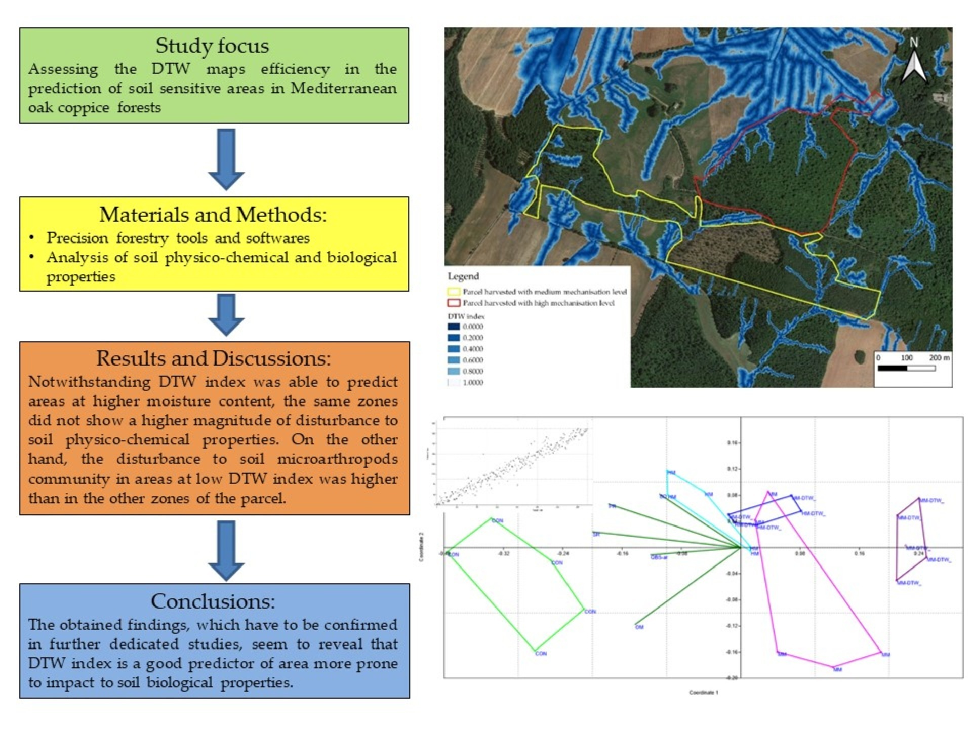
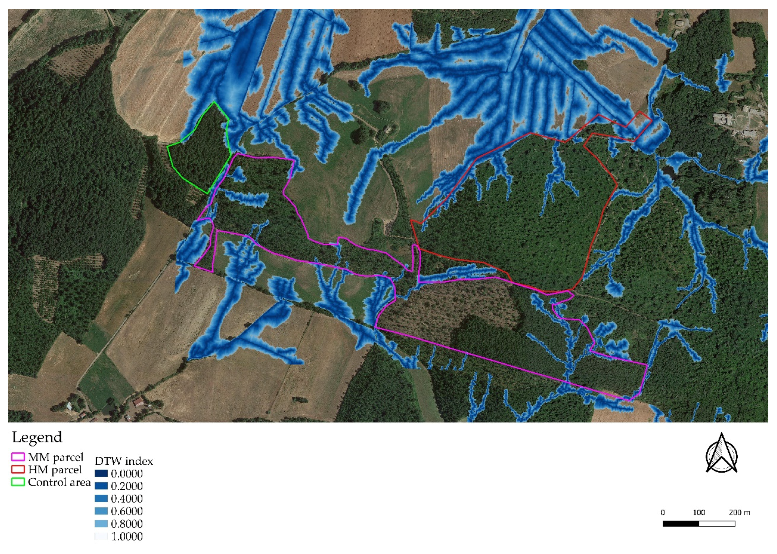
2.1. Study Area
2.2. DTW Map Development
2.3. Experimental Design
2.4. Soil Physico-Chemical Properties
2.5. QBS-ar Index (Soil Biological Quality Based on Microarthropods)
2.6. Statistical Analysis
3. Results
4. Discussions
5. Conclusions
Author Contributions
Funding
Informed Consent Statement
Data Availability Statement
Acknowledgments
Conflicts of Interest
References
- European Union. New European Forest Strategy for 2030. Available online: https://eur-lex.europa.eu/legal-content/EN/TXT/?uri=CELEX:52021DC0572 (accessed on 15 August 2021).
- Marchi, E.; Chung, W.; Visser, R.; Abbas, D.; Nordfjell, T.; Mederski, P.S.; McEwan, A.; Brink, M.; Laschi, A. Sustainable Forest Operations (SFO): A new paradigm in a changing world and climate. Sci. Total Environ. 2018, 634, 1385–1397. [Google Scholar] [CrossRef] [PubMed]
- Picchio, R.; Mederski, P.S.; Tavankar, F. How and How Much, Do Harvesting Activities Affect Forest Soil, Regeneration and Stands? Curr. For. Rep. 2020, 6, 115–128. [Google Scholar] [CrossRef]
- Ampoorter, E.; Van Nevel, L.; De Vos, B.; Hermy, M.; Verheyen, K. Assessing the effects of initial soil characteristics, machine mass and traffic intensity on forest soil compaction. For. Ecol. Manag. 2010, 260, 1664–1676. [Google Scholar] [CrossRef]
- Ampoorter, E.; Goris, R.; Cornelis, W.M.; Verheyen, K. Impact of mechanized logging on compaction status of sandy forest soils. For. Ecol. Manag. 2007, 241, 162–174. [Google Scholar] [CrossRef]
- Picchio, R.; Jourgholami, M.; Zenner, E.K. Effects of Forest Harvesting on Water and Sediment Yields: A Review Toward Better Mitigation and Rehabilitation Strategies. Curr. For. Rep. 2021, 7, 214–219. [Google Scholar] [CrossRef]
- Jourgholami, M.; Khoramizadeh, A.; Venanzi, R.; Latterini, F.; Tavankar, F.; Picchio, R. Evaluation of Leaf Litter Mulching and Incorporation on Skid Trails for the Recovery of Soil Physico-Chemical and Biological Properties of Mixed Broadleaved Forests. Land 2021, 10, 625. [Google Scholar] [CrossRef]
- Tavankar, F.; Picchio, R.; Nikooy, M.; Jourgholami, M.; Naghdi, R.; Latterini, F.; Venanzi, R. Soil natural recovery process and Fagus orientalis lipsky seedling growth after timber extraction by wheeled skidder. Land 2021, 10, 113. [Google Scholar] [CrossRef]
- Labelle, E.R.; Hansson, L.; Högbom, L.; Jourgholami, M.; Laschi, A. Strategies to Mitigate the Effects of Soil Physical Disturbances Caused by Forest Machinery: A Comprehensive Review. Curr. For. Rep. 2022, 8, 20–37. [Google Scholar] [CrossRef]
- Keefe, R.F.; Wempe, A.M.; Becker, R.M.; Zimbelman, E.G.; Nagler, E.S.; Gilbert, S.L.; Caudill, C.C. Positioning Methods and the Use of Location and Activity Data in Forests. Forests 2019, 10, 458. [Google Scholar] [CrossRef]
- Bont, L.G.; Fraefel, M.; Frutig, F.; Holm, S.; Ginzler, C.; Fischer, C. Improving forest management by implementing best suitable timber harvesting methods. J. Environ. Manag. 2022, 302, 114099. [Google Scholar] [CrossRef]
- Phelps, K.; Hiesl, P.; Hagan, D.; Hotaling Hagan, A. The Harvest Operability Index (HOI): A Decision Support Tool for Mechanized Timber Harvesting in Mountainous Terrain. Forests 2021, 12, 1307. [Google Scholar] [CrossRef]
- Palander, T.; Kärhä, K. Utilization of Image, LiDAR and Gamma-Ray Information to Improve Environmental Sustainability of Cut-to-Length Wood Harvesting Operations in Peatlands: A Management Systems Perspective. ISPRS Int. J. Geo-Inf. 2021, 10, 273. [Google Scholar] [CrossRef]
- Marčeta, D.; Petković, V.; Ljubojević, D.; Potočnik, I. Harvesting system suitability as decision support in selection cutting forest management in northwest Bosnia and Herzegovina. Croat. J. For. Eng. 2020, 41, 251–265. [Google Scholar] [CrossRef]
- Picchio, R.; Latterini, F.; Mederski, P.S.; Tocci, D.; Venanzi, R.; Stefanoni, W.; Pari, L. Applications of GIS-Based Software to Improve the Sustainability of a Forwarding Operation in Central Italy. Sustainability 2020, 12, 5716. [Google Scholar] [CrossRef]
- Flisberg, P.; Rönnqvist, M.; Willén, E.; Frisk, M.; Friberg, G. Spatial optimization of ground-based primary extraction routes using the bestway decision support system. Can. J. For. Res. 2021, 51, 675–691. [Google Scholar] [CrossRef]
- Jones, M.-F.; Arp, P. Soil Trafficability Forecasting. Open J. For. 2019, 9, 296–322. [Google Scholar] [CrossRef][Green Version]
- Kankare, V.; Luoma, V.; Saarinen, N.; Peuhkurinen, J.; Holopainen, M.; Vastaranta, M. Assessing feasibility of the forest trafficability map for avoiding rutting—A case study. Silva Fenn. 2019, 53, 10197. [Google Scholar] [CrossRef]
- Lidberg, W.; Nilsson, M.; Ågren, A. Using machine learning to generate high-resolution wet area maps for planning forest management: A study in a boreal forest landscape. Ambio 2020, 49, 475–486. [Google Scholar] [CrossRef]
- Salmivaara, A.; Launiainen, S.; Perttunen, J.; Nevalainen, P.; Pohjankukka, J.; Ala-Ilomäki, J.; Sirén, M.; Laurén, A.; Tuominen, S.; Uusitalo, J.; et al. Towards dynamic forest trafficability prediction using open spatial data, hydrological modelling and sensor technology. Forestry 2021, 93, 662–674. [Google Scholar] [CrossRef]
- Campbell, D.M.H.; White, B.; Arp, P.A. Modeling and mapping Soil resistance to penetration and rutting using LiDAR-derived digital elevation data. J. Soil Water Conserv. 2013, 68, 460–473. [Google Scholar] [CrossRef]
- Hoffmann, S.; Schönauer, M.; Heppelmann, J.; Asikainen, A.; Cacot, E.; Eberhard, B.; Hasenauer, H.; Ivanovs, J.; Jaeger, D.; Lazdins, A.; et al. Trafficability Prediction Using Depth-to-Water Maps: The Status of Application in Northern and Central European Forestry. Curr. For. Rep. 2022, 8, 55–71. [Google Scholar] [CrossRef]
- Tavankar, F.; Picchio, R.; Nikooy, M.; Jourgholami, M.; Latterini, F.; Venanzi, R. Effect of soil moisture on soil compaction during skidding operations in poplar plantation. Int. J. For. Eng. 2021, 32, 128–139. [Google Scholar] [CrossRef]
- Murphy, P.N.C.; Ogilvie, J.; Connor, K.; Arp, P.A. Mapping wetlands: A comparison of two different approaches for New Brunswick, Canada. Wetlands 2007, 27, 846–854. [Google Scholar] [CrossRef]
- Murphy, P.N.C.; Ogilvie, J.; Meng, F.R.; White, B.; Bhatti, J.S.; Arp, P.A. Modelling and mapping topographic variations in forest soils at high resolution: A case study. Ecol. Model. 2011, 222, 2314–2332. [Google Scholar] [CrossRef]
- Ågren, A.M.; Lidberg, W.; Strömgren, M.; Ogilvie, J.; Arp, P.A. Evaluating digital terrain indices for soil wetness mapping—A Swedish case study. Hydrol. Earth Syst. Sci. 2014, 18, 3623–3634. [Google Scholar] [CrossRef]
- Ågren, A.M.; Lidberg, W.; Ring, E. Mapping temporal dynamics in a forest stream network-implications for riparian forest management. Forests 2015, 6, 2982–3001. [Google Scholar] [CrossRef]
- Mohtashami, S.; Eliasson, L.; Jansson, G.; Sonesson, J. Influence of soil type, cartographic depth-to-water, road reinforcement and traffic intensity on rut formation in logging operations: A survey study in Sweden. Silva Fenn. 2017, 51, 2018. [Google Scholar] [CrossRef]
- Schönauer, M.; Väätäinen, K.; Prinz, R.; Lindeman, H.; Pszenny, D.; Jansen, M.; Maack, J.; Talbot, B.; Astrup, R.; Jaeger, D. Spatio-temporal prediction of soil moisture and soil strength by depth-to-water maps. Int. J. Appl. Earth Obs. Geoinf. 2021, 105, 102614. [Google Scholar] [CrossRef]
- Schönauer, M.; Prinz, R.; Väätäinen, K.; Astrup, R.; Pszenny, D.; Lindeman, H.; Jaeger, D. Spatio-temporal prediction of soil moisture using soil maps, topographic indices and SMAP retrievals. Int. J. Appl. Earth Obs. Geoinf. 2022, 108, 102730. [Google Scholar] [CrossRef]
- Di Marzio, N. An overview of forest cover and management in Italy. Nov. Meh. Sumar. 2020, 41, 63–71. [Google Scholar] [CrossRef]
- Camponi, L.; Cardelli, V.; Cocco, S.; Serrani, D.; Salvucci, A.; Cutini, A.; Agnelli, A.; Fabbio, G.; Bertini, G.; Roggero, P.P. Effect of coppice conversion into high forest on soil organic C and nutrients stock in a Turkey oak (Quercus cerris L.) forest in Italy. J. Environ. Manag. 2022, 312, 114935. [Google Scholar] [CrossRef] [PubMed]
- Murphy, P.N.C.; Ogilvie, J.; Meng, F.-R.; Arp, P. Stream network modelling using lidar and photogrammetric digital elevation models: A comparison and field verification. Hydrol. Process. 2008, 22, 1747–1754. [Google Scholar] [CrossRef]
- Mohtashami, S.; Eliasson, L.; Hansson, L.; Willén, E.; Thierfelder, T.; Nordfjell, T. Evaluating the effect of DEM resolution on performance of cartographic depth-to-water maps, for planning logging operations. Int. J. Appl. Earth Obs. Geoinf. 2022, 108, 102728. [Google Scholar] [CrossRef]
- Tarboron, D.G. A new method for the determination of flow directions and upslope areas in grid digital elevation models. Water Resour. Res. 1997, 33, 309–319. [Google Scholar] [CrossRef]
- O’Callaghan, J.F.; Mark, D.M. The extraction of drainage networks from digital elevation data. Comput. Vision Graph. Image Process. 1984, 28, 323–344. [Google Scholar] [CrossRef]
- Saxton, K.E.; Rawls, W.; Romberger, J.S.; Papendick, R.I. Estimating generalized soil-water characteristics from texture. Soil Sci. Soc. Am. J. 1986, 50, 1031–1036. [Google Scholar] [CrossRef]
- Venanzi, R.; Picchio, R.; Piovesan, G. Silvicultural and logging impact on soil characteristics in Chestnut (Castanea sativa Mill.) Mediterranean coppice. Ecol. Eng. 2016, 92, 82–89. [Google Scholar] [CrossRef]
- Shapiro, S.S.; Wilk, M.B. An analysis of variance test for normality (complete samples). Biometrika 1965, 52, 591–611. [Google Scholar] [CrossRef]
- Glass, G.V. Testing homogeneity of variances. Am. Educ. Res. J. 1966, 3, 187–190. [Google Scholar] [CrossRef]
- Pfanzagl, J.; Sheynin, O. Studies in the history of probability and statistics XLIV A forerunner of the t-distribution. Biometrika 1996, 83, 891–898. [Google Scholar] [CrossRef]
- Fisher, R.A. The Correlation Between Relatives on the Supposition of Mendelian Inheritance. Philos. Trans. R. Soc. Edinb. 1918, 52, 399–433. [Google Scholar] [CrossRef]
- Tukey, J.W. Comparing individual means in the analysis of variance. Biometrics 1949, 5, 99–114. [Google Scholar] [CrossRef] [PubMed]
- Kruskal, W.H.; Wallis, W.A. Use of Ranks in One-Criterion Variance Analysis. J. Am. Stat. Assoc. 1952, 47, 583–621. [Google Scholar] [CrossRef]
- Duncan, D.B. Multiple range and multiple F tests. Biometrics 1955, 11, 1–42. [Google Scholar] [CrossRef]
- STATISTICA, Version 7.0. Data Analysis Software System. StatSoft, Inc.: Tulsa, OK, USA, 2007. Available online: www.statsoft.com (accessed on 10 April 2021).
- Hammer, Ø.; Harper, D.A.T.; Ryan, P.D. PAST: Paleontological statistics software package for education and data analysis. Palaeontol. Electron. 2001, 4, 9. [Google Scholar]
- Schönauer, M.; Hoffmann, S.; Maack, J.; Jansen, M.; Jaeger, D. Comparison of Selected Terramechanical Test Procedures and Cartographic Indices to Predict Rutting Caused by Machine Traffic during a Cut-to-Length Thinning Operation. Forests 2021, 12, 113. [Google Scholar] [CrossRef]
- Sterzyńska, M.; Pižl, V.; Tajovský, K.; Stelmaszczyk, M.; Okruszko, T. Soil Fauna of Peat-Forming Wetlands in a Natural River Floodplain. Wetlands 2015, 35, 815–829. [Google Scholar] [CrossRef]
- Bhagawati, S.; Bhattacharyya, B.; Medhi, B.K.; Bhattacharjee, S.; Mishra, H. Diversity and density of Collembola as influenced by soil physico-chemical properties in fallow land ecosystem of Assam, India. J. Environ. Biol. 2020, 41, 1626–1631. [Google Scholar] [CrossRef]
- Aupic-Samain, A.; Baldy, V.; Delcourt, N.; Krogh, P.H.; Gauquelin, T.; Fernandez, C.; Santonja, M. Water availability rather than temperature control soil fauna community structure and prey–predator interactions. Funct. Ecol. 2021, 35, 1550–1559. [Google Scholar] [CrossRef]
- Jakšová, P.; Ľuptáčik, P.; Miklisová, D.; Horváthová, F.; Hlavatá, H. Oribatida (Acari) communities in arable soils formed under waterlogged conditions: The influence of a soil moisture gradient. Biologia 2020, 75, 243–257. [Google Scholar] [CrossRef]
- Venanzi, R.; Picchio, R.; Grigolato, S.; Latterini, F. Soil and forest regeneration after different extraction methods in coppice forests. For. Ecol. Manag. 2019, 454, 117666. [Google Scholar] [CrossRef]


| Parcel | Overall Surface (ha) | Surface at DTW Index ≤1 (ha) | Surface at DTW Index ≤1 Affected by Machinery Passage (ha) |
|---|---|---|---|
| High mechanisation (HM) | 16.59 | 2.09 | 0.13 |
| Medium mechanisation (MM) | 20.24 | 2.26 | 0.16 |
| Acronym | Treatment |
|---|---|
| HM-DTW | Areas identified as sensitive by DTW algorithm (DTW index ≤1) in the forest parcels harvested with high mechanisation level |
| HM | Areas not identified as sensitive by DTW algorithm (DTW index >1) in the forest parcels harvested with high mechanisation level |
| MM-DTW | Areas identified as sensitive by DTW algorithm (DTW index ≤1) in the forest parcels harvested with medium mechanisation level |
| MM | Areas not identified as sensitive by DTW algorithm (DTW index >1) in the forest parcels harvested with medium mechanisation level |
| CON | Control area consisting of unharvested oak coppice in the last 20 years located close to the two parcels |
| Treatment | Moisture % (AVG ± SD) | t-Value | p-Value |
|---|---|---|---|
| HM-DTW | 39.6 ± 2.2 | 6.566 | <0.001 |
| HM | 35.7 ± 1.9 | ||
| MM-DTW | 40.0 ± 3.9 | 7.930 | <0.001 |
| MM | 32.9 ± 1.9 |
Publisher’s Note: MDPI stays neutral with regard to jurisdictional claims in published maps and institutional affiliations. |
© 2022 by the authors. Licensee MDPI, Basel, Switzerland. This article is an open access article distributed under the terms and conditions of the Creative Commons Attribution (CC BY) license (https://creativecommons.org/licenses/by/4.0/).
Share and Cite
Latterini, F.; Venanzi, R.; Tocci, D.; Picchio, R. Depth-to-Water Maps to Identify Soil Areas That Are Potentially Sensitive to Logging Disturbance: Initial Evaluations in the Mediterranean Forest Context. Land 2022, 11, 709. https://doi.org/10.3390/land11050709
Latterini F, Venanzi R, Tocci D, Picchio R. Depth-to-Water Maps to Identify Soil Areas That Are Potentially Sensitive to Logging Disturbance: Initial Evaluations in the Mediterranean Forest Context. Land. 2022; 11(5):709. https://doi.org/10.3390/land11050709
Chicago/Turabian StyleLatterini, Francesco, Rachele Venanzi, Damiano Tocci, and Rodolfo Picchio. 2022. "Depth-to-Water Maps to Identify Soil Areas That Are Potentially Sensitive to Logging Disturbance: Initial Evaluations in the Mediterranean Forest Context" Land 11, no. 5: 709. https://doi.org/10.3390/land11050709
APA StyleLatterini, F., Venanzi, R., Tocci, D., & Picchio, R. (2022). Depth-to-Water Maps to Identify Soil Areas That Are Potentially Sensitive to Logging Disturbance: Initial Evaluations in the Mediterranean Forest Context. Land, 11(5), 709. https://doi.org/10.3390/land11050709