Article

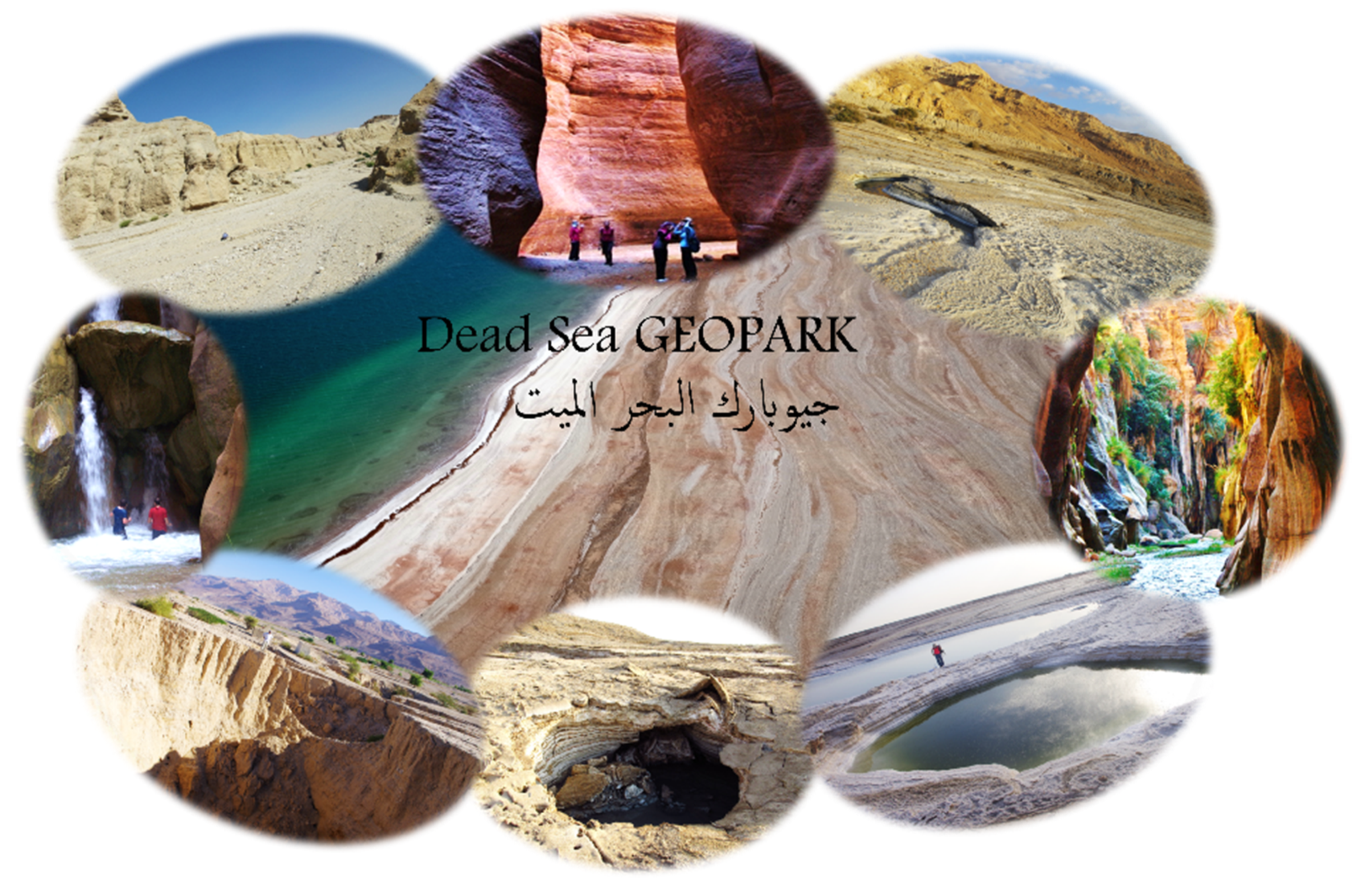
A Vision on a UNESCO Global Geopark at the Southeastern Dead Sea in Jordan—Geosites and Conceptual Approach

Dynamics of the Ocean Floor, Seafloor Modelling Group, GEOMAR Helmholtz Centre for Ocean Research, Wischhofstr. 1–3, 24148 Kiel, Germany
*
Author to whom correspondence should be addressed.
Land 2022, 11(4), 549; https://doi.org/10.3390/land11040549
Submission received: 28 February 2022 / Revised: 31 March 2022 / Accepted: 6 April 2022 / Published: 8 April 2022
(This article belongs to the Special Issue Geoparks as a Form of Tourism Space Management)

Abstract

:
A vision for the establishment of a Geopark in Jordan is given in this work, with a subsequent application to the UNESCO Global Geopark programme. The Dead Sea area and its surroundings have suffered strong changes in the last decades, accompanied by a variety of natural hazards related to enhanced erosional processes. The aspiring Geopark will thematically encompass the influence that these changes and related natural hazards, including flash floods and subsidence, have had on the local population, from geological, over historical up to recent times. The hydrogeology and geomorphology, i.e., the connection between erosion by water, dissolution of minerals, and landscape evolution, will be the main guiding theme that connects the Eastern Rim Highlands with the Dead Sea rift valley through ephemeral wadis, vegetated springs areas, and traditionally communities. The creation of the Geopark is aimed at holistic, sustainable development and management of the area by eco-tourism, and includes education on water resource management, hazard awareness and resilience, as well as international research. We here present the conceptual approach to the initial development of a Geopark network in Jordan. In a narrative discourse, we highlight realised and further implementation steps, with an evaluation of the expected timeline, potential partner institutions, regional involvement and the chances for realisation.

1. Introduction

Geotourism is a rising concept for sustainable development in rural areas [1]. Since 2015, the label, UNESCO Global Geopark (UGGp), expresses recognition of unified geographical areas with international geological significance and sponsors them through protection, education, and sustainable development in a holistic manner, usually in a bottom-up approach [2]. By the end of 2021, worldwide, 169 places were designated as UGGps and are part of the Global Geopark Network (GGN); the number of them is continuously rising [3]. A new initiative has started at the end of 2021 to develop a Geopark in Jordan in the surroundings of the Dead Sea (DS). A Geopark in Jordan would be the first on the Arabian tectonic plate and currently the fourth in the Middle East [4]; the closest ones would be Queshm Island (Iran), Troodos (Cyprus), and Kula-Salihli (Turkey).
The purpose of this work is to provide an overview of the geotouristic potential of the area and its unique geological and historical background. We present the achieved steps, highlight the challenges, and summarize the timeline and upcoming steps in order to build a stable roadmap for the establishment of the Geopark in Jordan. In a companion paper [5], we discuss concepts on geohazard mitigation for ensuring geotouristic activity in parts of the territory.

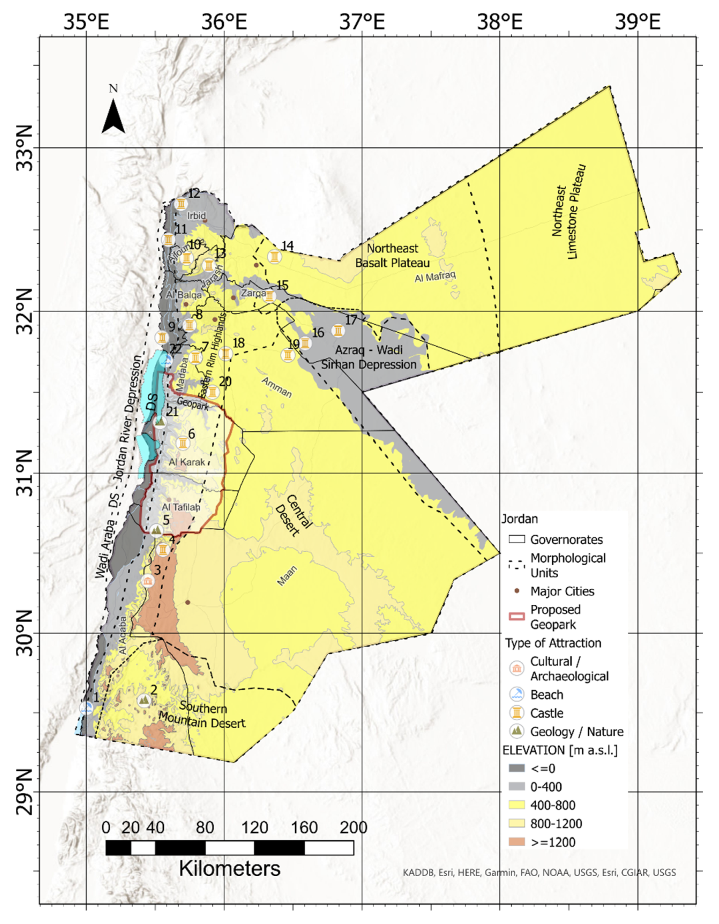
1.1. The State of Tourism in Jordan—A Potential for Geotourism

The tourism industry is regarded as one of Jordan’s most important economic sectors since it contributes significantly to job creation and exports. In 2017, the travel and tourism industry accounted for 18.7% of GDP [6]. Jordan’s tourism industry is mostly based on cultural tourism, with a focus on iconic locations, such as Petra and Jerash, but also offers diverse attractions such as the Dead Sea, Aqaba, Wadi Rum, and several nature reserves and adventure routes. With 13.3% annual growth projected in the worldwide adventure tourism market by 2026, Jordan has identified adventure tourism as one of the primary tourism markets to focus on in its 2021–2025 tourism strategy [7]. This aim broadens the range of tourism offerings available in Jordan. The creation of a Geopark at the Dead Sea shoreline can contribute to the growth of this profitable niche product and promote Jordan as a geological tourism destination.
Despite its modest size, Jordan’s geological diversity has a plethora of unique geological and geomorphological attractions to offer tourists (Figure 1). These components of nature serve as the foundation for both natural biodiversity and human culture. There are 11 natural reserves in Jordan [8]; two of the biggest are within the proposed Geopark area, Wadi Mujib, and the Dana Biosphere Reserve [9], both within the proposed Geopark area. Additionally, five touristic sites are considered world heritage (Petra, Wadi Rum, Um er-Rasas, the Baptism Site, and Quseir Amra), and several sites inside or close to the proposed Geopark area are on the tentative list of UNESCO [9]: Mujib, Quasr Bshir, Shobak Castle, and Dana. Furthermore, the cultural space of the Bedu in Wadi Rum and Petra is considered an intangible heritage [9].
Regarding geological heritage, however, a large percentage is susceptible to human distraction through a range of unsustainable activities, and only a small portion is promoted as tourism sites or products. Some of these geotourism attractions in Jordan and the Middle East were already addressed [10], highlighting the missed potential in not growing this tourism sector further, despite large benefits for the countries and motivation of tourists [11,12,13].
Thoughtful development of geotourism products in Jordan can significantly aid both the protection of the country’s geodiversity and the diversification of the tourism products that Jordan provides. The potential for geotourism development in the Wadi Rum desert and its role in preserving and strengthening the area’s geological heritage was already explored [14]. The authors emphasized the necessity of collaboration between players in science, business, government, and non-governmental organisations in the construction of new geotourism sites in Jordan. Furthermore, early community involvement might help establish alternative sustainable job opportunities and income in rural regions [15].
Despite the fact that many of the tourist products available in Jordan can be easily linked to the geological attractions and geodiversity of the places in which they occur, this has not yet been the case. For instance, in 2019, a letter of intent to recognize Wadi Mujib Biosphere reserve and some surrounding areas was submitted to the UNESCO Geopark committee [16]. The proposed Geopark is located at the eastern shoulder of the Rift Valley of Jordan, along the shoreline of the Dead Sea, with a total area of 387 km2 [16]. Together with Petra, and Wadi Rum, these sites could be termed potential geotourism highlights of the country. However, geotourism, which is partly linked to adventure tourism in Jordan, is in its initial stages, as the tourism strategy indicates, and will be increasingly established in the coming years.
Our suggested larger Geopark area will include the entire area of the Wadi Mujib canyon as its northern boundary. The establishment of such a new, large Geopark in the country may be used to drive the offering of geotourism products, a topic that has recently gained attention from authorities, geological communities, and tourism actors. A point that became clear in 2021 with the formation of Jordan’s National Committee for Geopark and Georeserve Management and the approval of a new Geological Reserves By-Law [17] by the Jordanian Ministry of Energy and Mineral Resources (MEMR). The concept of a Geopark will also help to address issues of the National Climate Change Adaptation Plan [18,19], a fundamental action plan to find sustainable solutions for the increasing number and severity of climate-related hazards, as outlined below for the Dead Sea area.

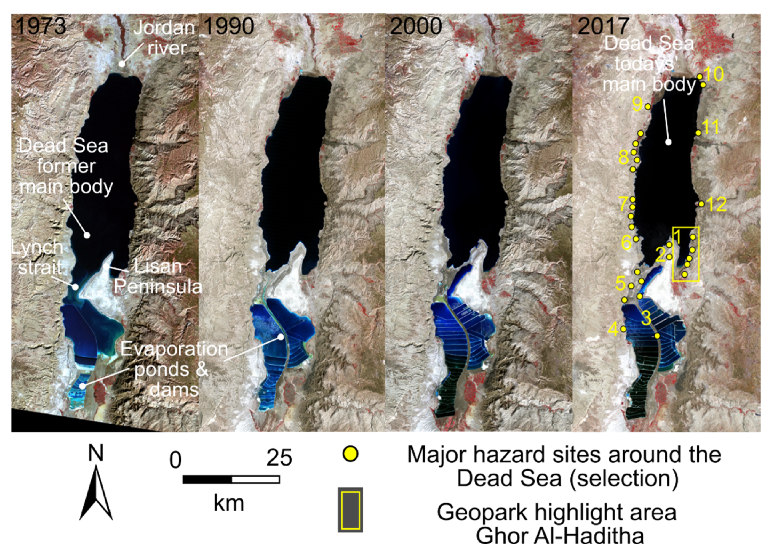
1.2. The Dead Sea and Its Surroundings

The Dead Sea area is a unique place on Earth of high international, historical, and hydrogeological significance. The hypersaline terminal lake located in the Dead Sea-Red Sea rift system counts as one of the saltiest water bodies with 9.6 times more dissolved salt minerals than the oceans and is the deepest hypersaline lake with a depth reaching 300 m [20]. Its shores also form the lowest elevation on continental Earth, with a current water level of −435 m below mean sea level [21]. Its composition has evolved from predecessor lakes during late Neogene-Quaternary, subsequent fresh-water inflow and evaporation [22]. Its main tributary is the Jordan river, but also numerous ephemeral streams, wadis, aquifers, and submarine springs provide inflow to the lake [23]. The main groundwater bearing formations in the proposed Geopark area are the shallow alluvial aquifer of the Lisan formation of Tertiary and Quaternary origin, the mostly karstified limestone of the Amman-Wadi Es Sir aquifer of the Belqa and Ajlun groups of the Upper Cretaceous, the limestone/marl formations of the Ajlun group, the Kurnub sandstone aquifer of the Lower Cretaceous and parts of the Zarqa group of Triassic-Jurassic age as well as parts of the Ram (Disi) fossil groundwater aquifer of Cambrian origin [24,25]. The Dead Sea serves hereby as the main “sink“ in the hydrogeologic system of the region, having tributaries that range more than 100 km inland [26].
The Dead Sea has been an economic resource for ten thousand years providing minerals and materials such as salt, potash, asphalt, and balsam, as well as fertile areas to grow dates and sugar [27]. It has been an important place on the trade route between Asia and Europe, and its salty mud is considered to have important therapeutical and medical properties.
In the last decades, however, the human and natural impact has accelerated the changes in the natural system, leading to a rapid decline in the water level of the lake (Figure 2, based on satellite images from [28,29]). The shorelines of the lake suffer from an increase in natural hazards related to desertification and erosion, such as sinkholes, landslides, salt storms and flash floods, all of these are prominent examples that caused life and economic loss [23,30,31,32,33,34,35,36] recently. The sad highlight in this context is the flash floods of Wadi Ma’in and Wadi Musa that caused high death tolls in Jordan in October 2018 [37].
Communities surrounding the Dead Sea have suffered both directly from these natural hazards and rapid changes in the hydrogeological system, as well as indirectly in longer terms, concerning economy, micro-climatic changes and water shortage, all with effects on agriculture and general life (cf. companion paper [5]). Currently, an ambitious Worldbank project termed the Red Sea-Dead Sea conveyance belt aims at stabilising the Dead Sea lake level and providing water and electricity conveyance to the neighbouring countries [38,39,40], part of the fresh water carrier being in the proposed Geopark extent [39]. However, the realisation is still unclear [41,42].
As a consequence of this development, an effort has been made recently to provide alternative sources of income and water management for the region. As part of this effort, we proposed the establishment of a UGGp, committed to the UN sustainability goals [43]. We here present a concept for sustainable management of the Dead Sea coastal area and its mountain and desert surroundings in a holistic approach put into a Geopark framework. This paper focuses on the conceptual approach, the geological background and the initial assessment of geosites, lists administrative procedures and provides a discussion on possible benefits and drawbacks of the realisation of this project. In a companion paper [5], we particularly focus on the necessary establishment of geoscientific monitoring in hazardous zones in order to provide early-warning strategies for the population and tourists in connection to scientific research.

2. Objectives, Performed and Anticipated Methods

The main objective of the establishment of a Geopark at the SE Dead Sea is to enable sustainable development through an integrative management strategy following the criteria for the UNESCO Global Geoparks [2]. Starting from both the grassroot and political level, the aim is to attain a UNESCO Geopark status within the next 5–10 years. The establishment of a Geopark must come from and/or be in accordance with the local population, on all levels, as mentioned in, e.g., [44].
We use field and literature research and communication with stakeholders and relevant groups in the country (local inhabitants, NGOs, and governmental bodies) to initiate and foster the Geopark project for the Dead Sea area. The objectives of the project, including the anticipated methods, are listed (not in order of importance):
International Recognition: Through this holistic approach, the area will gain international recognition and visibility, creating structures for international projects contributing to the Jordanian natural resource management, infrastructure and touristic sector. This would potentially become the first of its kind on the Arabian plate and the fourth in the Middle East. As a method, the integration and communication with international partners and partner Geoparks are envisaged and has already been started.
Sustainable Eco-tourism: Local communities shall have alternative sources of income and possibilities for development while preserving culture and traditions. The involvement of the local population is a requisite for the aspiring Geopark, ranging from management and stakeholder activity to visitor guidance, local investments, and businesses. The methods for integration of the local population are manifold and range from local economic boosters to management, offered workshops, and courses.
Education: This wide-ranging topic addresses pupils of local communities over national schools, international students, visitors, local stakeholders, and up to international science. This includes, on a voluntary basis, for example, water resources management, geohazard preparedness and mitigation and protection of the environment from “local to global interrelation”, as well as information about changing lifestyles due to changing environment. Anticipated methods are teaching programs and workshops on all levels.
Scientific Monitoring: The unique setting of this Geopark and the dynamic development will foster international scientific projects within the area and beyond, and international research institutions from the US, Ireland and Germany have already expressed their interest in a Geopark in Jordan through letters of support. Scientific advice on safe areas for visitors, the impact on ecosystems and recommendations on land-use will be of high importance for the development of the region. The methods for scientific monitoring are supposed to contain all up-to-date aspects of GIS, geo- and bioscientific research. An example of hydrogeophysical monitoring is explained for the highlight region Ghor Al-Haditha sinkhole and subsidence site in a companion paper [5].
Protection of the Nature and Geologic Heritage: As a side effect of the voluntary efforts of the inhabitants of the area, this assignment of a Geopark will lead to long-term sustainable usage and conservation of the natural landscapes, and heritage of the area, which is an important aspect of nature conservation more generally [45]. This will help to maintain the cultural connection between the inhabitants and the landscapes. Anticipated methods include those mentioned above, including assigning specific protection areas and promotion of the Geopark.

3. Results: Background, Geosites and Concepts for the Aspiring Geopark

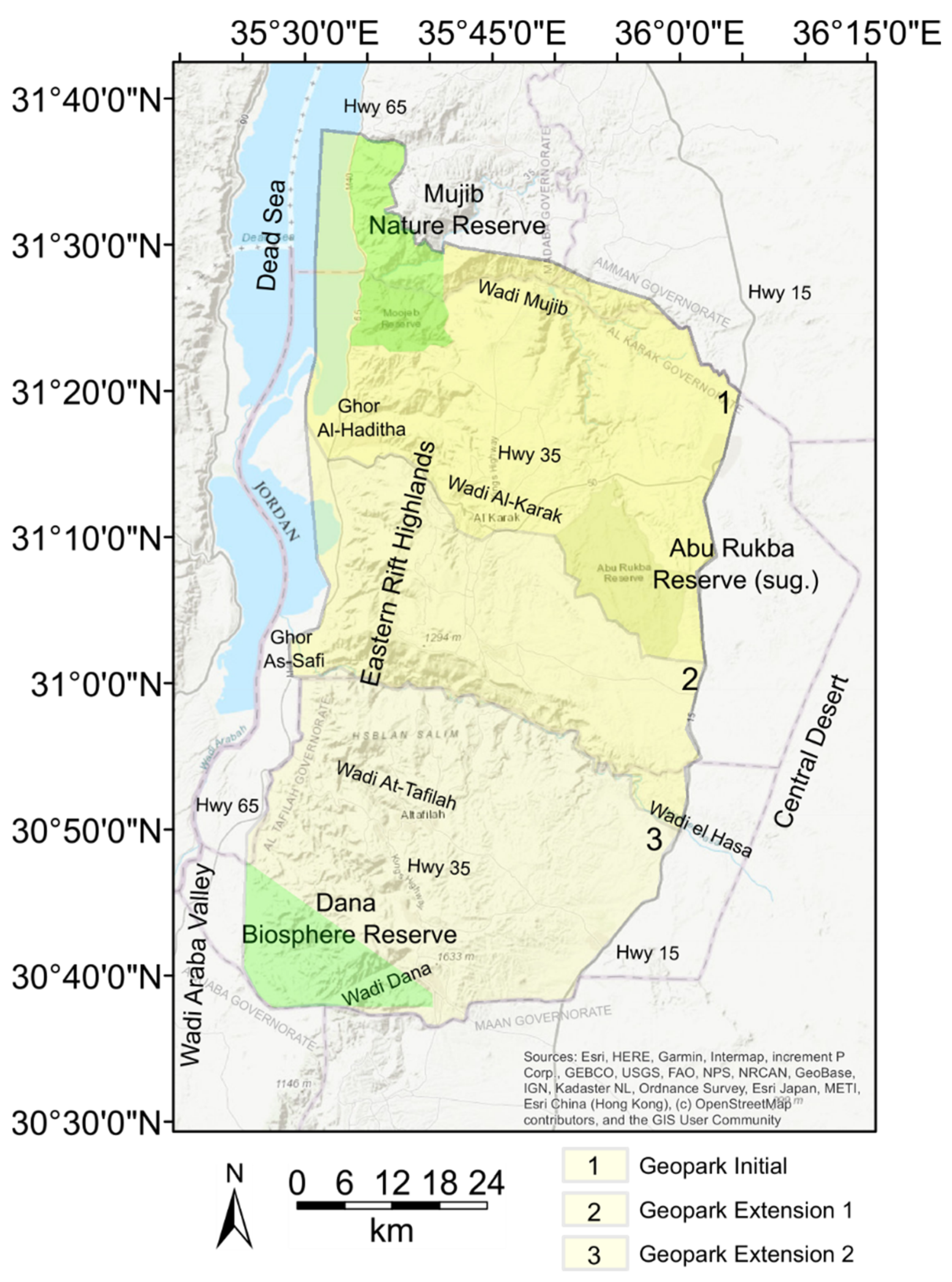
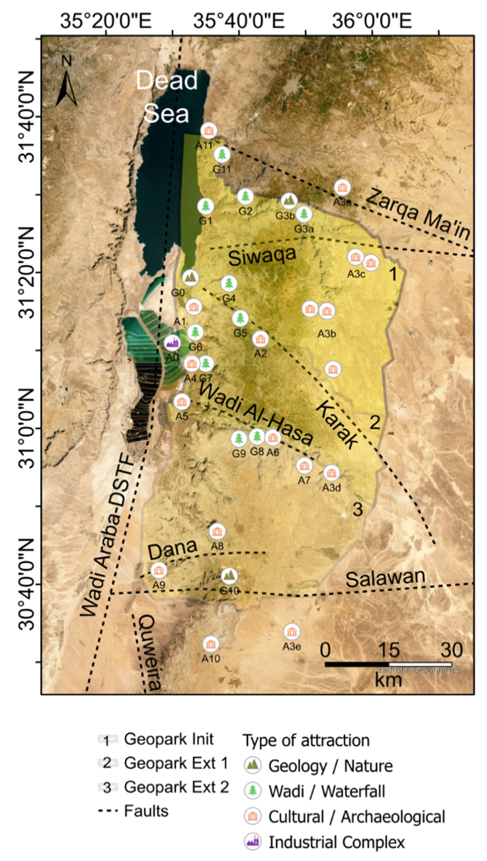
3.1. Extent and Infrastructure of the Geopark

The suggested Geopark zone (Figure 3) lies between the Western Red Sea-Dead Sea transform fault and depression and the Central Plateau of Jordan. The corner coordinates are: SW corner 35°23′15.012″ E 30°40′25.535″ N; SE corner 35°49′30.784″ E 30°37′51.498″ N; NW corner 35°31′28.44″ E 31°37′49.596″ N; NE corner 36°4′6.394″ E 31°18′51.668″ N. The suggested initial extent includes an offshore part in the Dead Sea, the suggested western limit of the Geopark lies ca. 5 km eastwards of the centre line of the Dead Sea and is limited by the highest topography of the Lisan Peninsula shoreline in the West and the Wadi Araba plains (Highway no. 65). The size of the initial Geopark area would encompass around 1900 km2; with the first extension, it would encompass 3050 km2, and the final size is planned to reach 4900 km2. A possible offshore extension of the Geopark in the years after initialization will be discussed, and it has to be considered carefully with the regression of the Dead Sea. The whole Geopark area would encompass a hydrogeologic catchment area of approximately 12,000 km2, as it extends partly over most of the Dead Sea Subbasin and parts of the Jafr and Wadi Araba North basin [26].
The first extent lies almost entirely in the Al-Karak Governorate; towards the north, it includes the Wadi Mujib Biosphere reserve, including the part of the governorate Madaba limited by the administrative border to the Amman Governorate. Towards the east, it includes the highlands of the Al-Karak Governorate (also called Moab mountains) up towards the central desert plateau, including the (suggested) Abu Rukba Reserve and limited by the Highway no. 15. Towards the south, the aspiring Geopark would be first limited by the Wadi Al-Karak for planning and organisational purposes. However, the suggested southern extent (no. 2 and 3 in Figure 3) will be increased twice, ranging first to the administrative border between Al-Karak and At-Tafilah governorates (Wadi Al-Hasa) and then, in a second step, up to the Dana Biosphere Reserve, finally limited by the administrative borders to the Maan and Aquaba governorates. The two outer highways and the King’s Highway (no. 35) form major access routes into the area.
The project to re-establish the southern parts of the former Hedjaz railway could also allow access to the proposed territory and has been underway since 2010, but the current progress and time plan are unclear [46].

3.2. Regional Climate

According to [26], the climate of the proposed Geopark area ranges from Saharan type hot arid and semi-arid (Dead Sea), over warm, Mediterranean type (Eastern Rim Highlands) to cool semi-arid desertic type (central desertic plateau). The rainy season ranges from November to April. Mean annual precipitation of the last 30 years [47] ranges from less than 50 mm in the desertic areas (e.g., Dead Sea), to over 100–200 mm in Tafilah and Karak governorates, to more than 300 mm in the mountainous areas (e.g., Madaba). The area can be affected by a strong and hot Shirocco wind blowing from the Egyptian Desert, which brings dust and sandstorms. The area is characterized by great micro-climatic differences because it ranges from the high mountains to the Dead Sea with an altitude difference of more than 2000 m. The highest peak inside the area is Jabal Al-Ataitah with 1633 m, and the lowest place is the Dead Sea shoreline with −435 m, below the mean sea level.
These features of the hydrological cycle have formed the unique landscape and evaporite deposits over geological to recent times, connecting the desertic plateau in the central part of Jordan through the steppes and the Eastern Highlands with the Wadi Araba Valley, thus providing unique physiographic environments for the inhabitants of the region with the continuous adaptation of lifestyle.

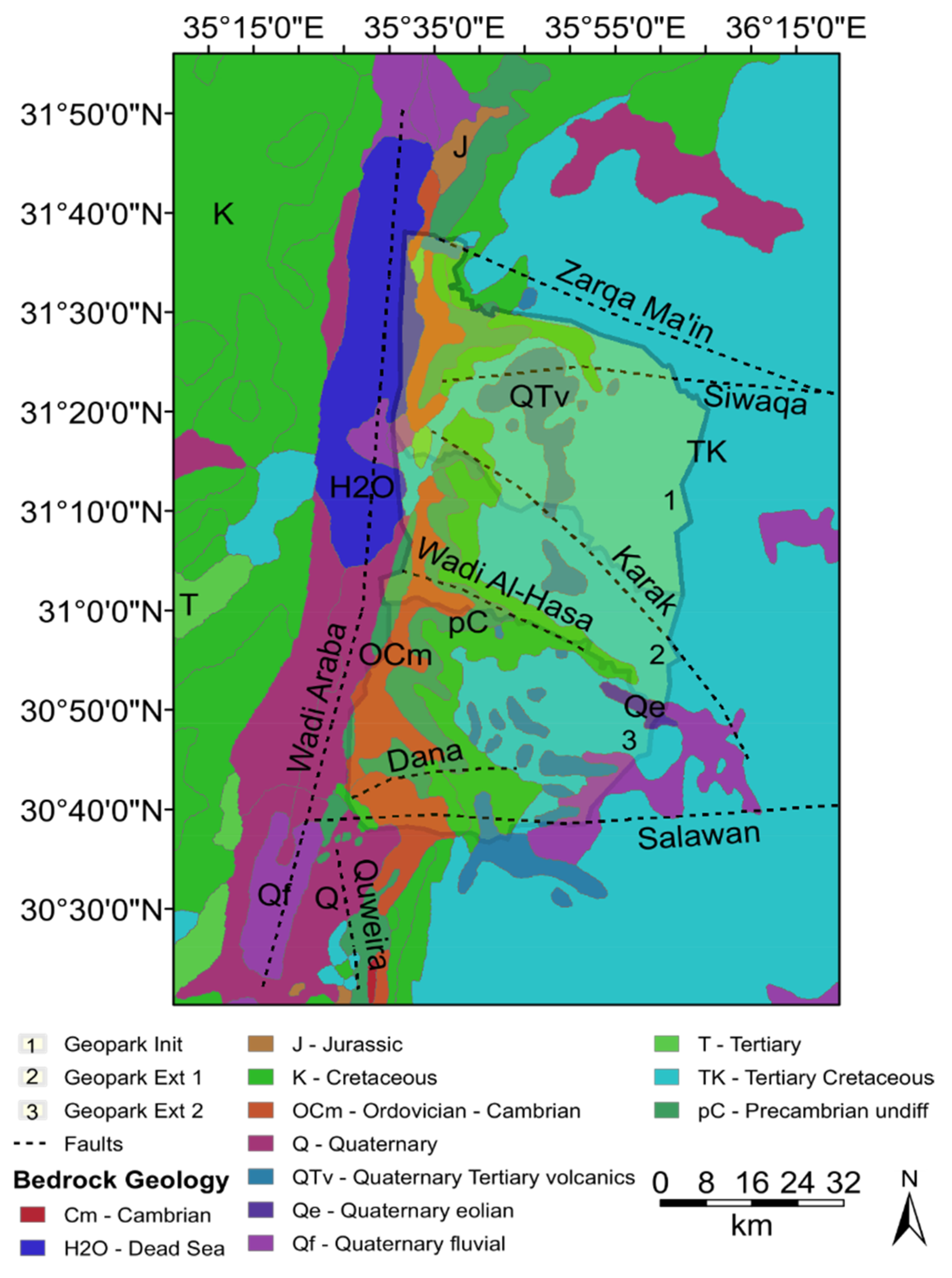
3.3. Geology of the Proposed UGGp Territory

The hydraulic system and natural hazard appearance described in Section 1.2 are closely linked to the geological peculiarities of the region. Figure 4 shows a geological map with the most important fault system and geologic units.
Geologically, the Geopark will span Earth’s history from the Early Cretaceous (Highlands and desert plateau to the east) to Quaternary (fertile plain “Ghors” to the west, see Figure 4). The territory contains a variety of geologic features from Cambrian (Umm Ishrin Sandstone), over Cretaceous (Kurnub, Ajlun and Belqa groups) up to the Quaternary deposits in alluvial fans, volcanic rocks (Neogene basalt), parts of the Lisan salt diapir and the recently exposed shoreline of the Dead Sea. Locally, in the southern limit of the proposed extent, even Precambrian and Cambrian porphyrites are exposed [49].
Tectonically, the proposed Geopark lies on the Arabian Peninsula, and is limited to the west by an active rift zone, the Dead Sea Transform Fault (DSTF) [50], expressed as graben structures, strike-slip and oblique faults (e.g., Wadi Araba, Ghor Safi, Siwaqa, Zarqa-Ma’in), normal faults (e.g., Karak) as well as flexure zones (e.g., Ed-Dhira) and other lineaments (e.g., Dana fault) [26,48,51,52]. The highlight and focus area of the Geopark (G0) lies near the SE shore of the DS, near Ghor Al-Haditha. It encompasses the active subsurface erosion zone, with a large variety of recent sinkholes and subsidence formations as well as a potpourri of mostly clayey-silt sediments consisting of a variety of precipitated evaporite minerals such as aragonite, gypsum, halite, and dendritic particles such as limestone, quartz, and clay found all along the DS shore [51,52,53].
All geologic units are subject to strong erosive forces of wind and water; hence morphologies of spectacular appearance have formed in the predominant sandstones, limestones and salt-containing rocks of the area. Furthermore, volcanic activity since Paleogene has led to the appearance of thermal springs and hot thermal waters. More details on these features are provided in the following.

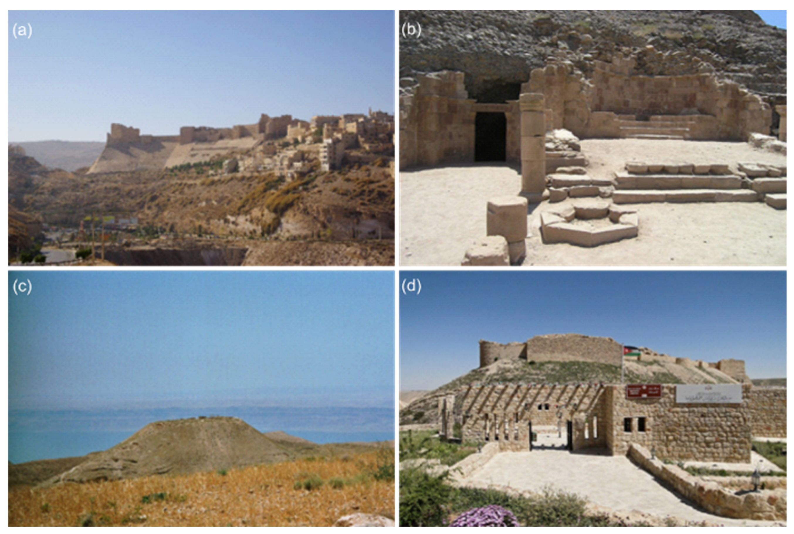
3.4. Geologic and Archaeologic Heritage of International Significance

Generally, the Geopark area includes multifaceted geological features combined under an umbrella topic related to erosion, including both very old and very recent evolution, so it spans a large range of Earth’s history and includes local natural ecosystems in a semi-arid climate. A logo for the Geopark is suggested (Figure 5), covering the above-mentioned main theme.
Several potential sites for the aspiring Geopark have been identified in the territory, and an initial compilation is provided below. The geographic map (Figure 6) is based on [29], with the proposed extent of the Geopark and the most important geological/ecological and, as an asset, archaeological/cultural features. It highlights the location and type of the sites inside or in close proximity to the suggested extent. Table 1 below provides a list of all features (G) that are of geotouristic interest. Additionally, it provides a list of features (A) in the Geopark area of archaeological/cultural interest.
The Highlight Area-Ghor Al-Haditha Sinkhole and Subsidence Site (G0)
Figure 7 shows aerial photos of the on- and offshore morphological features of the highlighted area (G0 in Figure 6) of the proposed Geopark near Ghor Al-Haditha. The geological features of the highlighted area are presented in detail in a companion paper [5] that deals with the associated natural hazards and geoscientific monitoring.
The inner mountains and desertic plateau—G1–G10
Lime/sandstone formations and fossils: In the Moab mountain areas, the succession of marl, sandstone, and limestone of cretaceous to tertiary age has left a portfolio of various impressive erosive structures through the epochs of water and wind erosion (Figure 8). Fossils (a) are abundant, and especially late Permian plants have been discovered in the Umm Irna sand-siltstone formation near the Dead Sea in the last decades [54]. Widespread sandstone erosion at the margins of wadis and on top of the mountains form sculpture-like structures (b–d). Moreover, more recent mineralization can be found, e.g., sulphur accumulations (e) and sinter (f).
Wadis and waterfalls: Wadis are the most classical and stunning feature of this semi-arid climate zone (Figure 9). Episodic runoff and flash floods form the undulating wadi margins and beds (a), transporting material from clay to cobble size. Wadi Ibn Hamad is the most prominent in the highlighted area of the proposed Geopark (b), while Wadis Mujib, Al-Hasa, Numeira, and Al-Karak are famous for their hiking trails and waterfalls. A detailed analysis of the geotouristic potential for each site will be established upon further implementation of the Geopark, and establishing a geosite inventory will be one of the first steps (cf. Section 3.7.2). Further geological features, such as mines and typical mineral resources of the region, will also be included, but are beyond the scope of this work.
Archaeological/cultural heritage—A0–A10
Many civilizations have occupied the land of Jordan throughout history due to the importance of its position as a crossroads between Asia, Africa, and Europe; nonetheless, the present state is relatively young, having emerged following the fall of the Ottoman Empire during World War I. The Hashemite Kingdom of Jordan has a land area of around 90,000 square kilometres and is located in the northern section of the Arabian plateau [1,55], bordered by Syria in the north, Iraq in the east, Saudi Arabia in the south, and Palestine and Israel in the west.
The suggested Geopark area and its surroundings are rich in historically important places. From the Early Bronze Age, over the Nabatean/Greek/Roman/Byzantine ages, over Umayyad and through to the Ottoman Empire, temples, roads, and cities are distributed throughout the entire area. Figure 10 shows a few places of historical importance in or close by the proposed UGGp area, while Figure 6 includes the locations of these sites on the map. Further archaeological remains, such as burial grounds, are located in the proximity of the Geopark area (Lisan Peninsula, Ghor Al-Safi).
The connection between the geomorphology (wadis, mountains and valley) and the history of the region can be nicely seen in the historical development and division of the region following [26] and references within. The proposed Geopark area shows traces of human activity since the Paleolithic (e.g., Wadi Al-Hasa sites [56]), the first villages of the Neolithic era (e.g., Dhra) and the first fortified settlements of the Bronze Age (e.g., Numeira, Khirbet en-Nahas) mostly in the wetter highlands. During the Iron Age, the Transjordanian.
Figure 10. Archaeological sites in or close to the proposed Geopark area. (a) Al-Karak crusader castle, photo from [57]. (b) Lot sanctuary and the entrance to Lot cave at Ghor As-Safi, photo from [58]. (c) The fortified hilltop palace of Machaerus, Tal Mkawer, in Madaba. Photo from [59]. (d) Shobak or Montreal crusader castle, photo from [60].
Land 11 00549 g010
Kingdoms emerged with the main wadis Mujib and Al-Hasa separating Edom, Ammon, and Moab (i.e., Sela castle near At-Tafilah). Traces of Egyptian, Babylonian and later Persian influence mark the transition to the Hellenistic period, during which the kingdom of nomadic people from Arabia, the Nabataeans, emerged south of Wadi Al-Hasa, located around the most famous world heritage site Petra in Wadi Musa, but also other remains inside the proposed Geopark area (Tannur, Dharih). Already before the Roman conquest, the region had become a major trade route as part of the Silk Road (E-W) and the Incense Road (N-S), of which heritage in the form of fortified cities and later paved roads (Via Nova Traiana) exist. This forms still today a major traffic road (The Kings’ Highway, no. 35). The Romans also built the Limes Arabicus with a considerable number of fortified places. During the Byzantine period, some of these places (e.g., Umm Al-Rasas) became large rural market towns, and shrines and buildings of Christian origin spread in the area. At Ghor Al-Safi, a Byzantine basilica (Lot’s cave) can be found. In the following Islamic period, Umayyad and Abbasid castles (Shuqayra Al-Gharbiyya at Wadi Al-Hasa) and especially crusader castles survived (e.g., Karak, Shobak), and the region became known as part of Bilad Al-Sham. The Mamluks created the Al-Karak province with Wadi Zarqa as the border to the Damaskus province in Transjordan. This resembled the modern division of the country, which was further shaped by a long period of Ottoman rule under which the Hijaz railway was built that crossed part of the proposed Geopark territory. Following the colonial occupation, the Arab Revolt lead finally to the foundation of the modern state of the Hashemite Kingdom of Jordan.

3.5. Socioeconomic Considerations

Jordanian society is characterised by complexity and heterogeneity. The majority of Jordanians are of Arab descent, with roots in some prominent Arab tribes [61]. Other ethnic communities in Jordan include Circassians, Chechens, Druze, and Armenians [61]. Among these groups, the Bedouins are the most important in terms of political power and social presence [55]. Furthermore, Bedouin beliefs and customs continue to have a significant impact on society. In terms of religion, the majority of Jordanians are Muslims, while there are small Christian and Druze minorities [55]. The approximate number of people living within the proposed Geopark area is 120,000–150,000; see Table 2 for a list of the larger communities. In the area of the proposed Geopark, the main settlements are urban, with the largest cities being Al-Karak and At-Tafilah [62]. However, rural settlements and Bedouin semi-nomadic lifestyles also exist. People follow a traditional lifestyle with basic income resources. Most of them work in farming, local trading, craft, mining (potash), or permanent governmental and military jobs while having a small herd of livestock to meet their basic dietary needs of meat and dairy products, which also helps to improve their income when produced and sold locally. For a detailed description of the typical life-sustaining activities with a focus on the highlighted area (G0), please refer to the companion paper [5].

3.6. Potential Geotouristic Activity and Infrastructure

Local and international tourists are already visiting the many attractions within the proposed Geopark area. A number of natural tourism centres already operate inside the Geopark and surrounding regions, offering guests a range of activities such as hiking, trekking, bike tours, and other local experiences. The majority of these centres also offer environmental education programs to their local communities and tourists (see Table 3). For example, the Mujib Biosphere Reserve received 28,000 visitors in 2019 prior to the COVID-19 [8]. It goes from an elevation of −433 m below sea level near the Dead Sea shore up to 1000 m above mean sea level at the eastern side, which is considered the Grand Canyon in Jordan. With cliffs that drop around 1000 m at some points, the canyon cuts and exposes various types of strata giving the site its geological significance as it reveals the majority of Jordan’s and near areas’ geological history, from the early Middle Cambrian to the Recent [63]. The population around the site is estimated to be 30,000 [16]. The reserve has full-time staff working in site management, surveillance, eco-tourism, and geologic/ecologic guided tours; it also offers accommodation for tourists. The Geopark will collaborate with these entities to add new geotourism-focused activities to the existing ones. This will expand their available activities and programs, allowing them to reach out to new travellers and cater to their needs. Furthermore, collaboration and utilization of existing facilities and infrastructures will speed up and simplify the development of geotourism products inside the Geopark area.

3.7. Implementation—From National Geopark to UNESCO Global Geopark

3.7.1. Realised Efforts

As described in Section 1.1, the first initiative to develop a Geopark in Jordan was undertaken by RSCN since 2016 for the Wadi Mujib area. At the end of 2021, a contribution to the Global Geopark Network conference (GGN2021) in Jeju, South Korea, on a vision for a larger Geopark in Jordan, has been presented [64]. Meanwhile, a UNESCO accredited National Geopark Committee led by the Ministry of Energy and Mineral Resources under the supervision of the Jordan National Commission for UNESCO (JoNatCom) was established, with at least 14 members initially. With continuous effort through digital and personal contact with several governmental bodies (MEMR, Jordan Tourism Board) and non-governmental organisations (JoNatCom, RSCN, Al-Numeira), a roadmap for the continuation of the implementation efforts is being defined. Large parts of this plan are presented in the following paragraphs.

3.7.2. Timeline

In the following, a suggested timeline (Figure 11) for implementation of the Geopark is presented, which is subject to change and additional detail at later stages.
(1) 
Year 2022
  • National Geopark Committee meetings and initial workshop 2022 with framework planning of finances, extent, and initial partners.
  • Application to UNESCO grant for the Geopark initiation in Africa and the Middle East.
  • Networking with other UNESCO Geoparks and possible partners: inhabitants, local stakeholders, politicians, scientific advisors, touristic agencies, NGOs.
  • Looking for sponsors for different aspects of the aspiring Geopark–e.g., UNESCO support workshops and capacity building, USAID, UNICEF, KfW, SEG, GIZ, UNDP.
  • Initialization of Scientific pre-surveys and activities (e.g., projects to monitor safe areas, cf. Section 3.7 and companion paper [5]).
  • Artist project about sinkhole highlight area.
  • White Paper/publication in MDPI–Land-SI Geoparks.
  • Beginning of the geodiversity assessment
(2) 
Years 2023–2024
  • Grassroot initiatives to establish management, tourism, and maintenance structures.
  • Participation of the Applicant in UNESCO Geopark workshops/schools.
  • Legalization as National Jordanian Geopark.
  • Beginning of Geodiversity Inventory with an evaluation of geotouristic potential.
  • Beginning of promotion of the Geopark.
  • Beginning of investment in infrastructure.
  • Extension phases 2 and 3 (cf. Figure 3).
  • Scientific activity and workshops on water management, educational activities, and infrastructure development.
(3) 
Years 2025–2027
  • Application to accredit the status of UNESCO Global Geopark.
  • First outcome of the scientific activities (publications).
  • Investments.
  • UNESCO evaluation procedure, adaptation, possible re-application.
(4) 
After 2027
  • Continues adaptation with possible inclusion of other areas, new partners, investment, running, management and checks by UNESCO.

3.8. Planned Actitivities and Management

In the following, an initial list of proposed activities to be performed in the context of a Geopark natural site is presented.

3.8.1. Eco-Tourism and Infrastructure

A Geopark information centre should be established in Ghor Al-Haditha, and information centres may follow on the E boundary of the Geopark, near the plateau (e.g., Al-Karak, At-Tafilah and maybe also near Shubak). Other information would be integrated into the facilities of the Wadi Mujib and Dana Natural Reserves. Touristic infrastructure and facilities will potentially be built in the Geopark area and its surroundings, consisting mainly of eco-hostels and farm stays in the territory, as well as homestays/hostels in Ghor Al-Haditha and Ghor Al-Mazra’a and on the eastern plateau. Archaeological sites, e.g., the burial sites near Ghor Al-Safi further south and Al-Karak historical town nearby, make the area attractive for a longer stay.
The activities/infrastructure include walkways into wadis, along the shoreline, walkways around the safe areas of the sinkhole zone and onto mountains, geo-urban routes cf., e.g., [65], boat tours, culture guides, guided walks through (hydro)geological heritage, archaeological heritage and eco-systems, art exhibitions, local workshops, local food and products, and particularly women-led initiatives. Inclusion with the explanatory museum in the DS panoramic complex would be advantageous; generally speaking, inclusion into Jordan’s tourism agenda more broadly as a sustainable tourism opportunity is planned. An integration into long-distance walkways joining culture, history, and nature to form the Jordan trail, is desirable.

3.8.2. Education and Society

It is planned to have a museum based on the interaction between humans and landscapes in the region. Local workshops will provide courses on many region-related topics such as nature, photography, geology, hand-crafting, arts etc., following established art-science-nature concepts [66]. Guided tours also count into the topic of education. Most importantly, a regular initiative on water management for different levels such as schools, students, and stakeholders will be initiated and be an essential part of the Geopark project. It is envisaged to participate in the summer university network of the UNESCO chair on Geoparks, Regional Sustainable Development and Healthy Lifestyles led by the University Trás-os-Montes (Portugal), focusing on capacity building [67]. Furthermore, history and archaeology will be told during events, as well as information about earthquakes at the Dead Sea rift. Such events may include the style “geologist”, “biologist”, or “archaeologist for a day” to provide interaction between young people and scientists, but many more styles are possible. For the local community, the aspiring UGGp will offer women-empowerment workshops and training on irrigation techniques and civil science projects.

3.8.3. Science

A scientific project (MORFES, cf. companion paper [5]), dedicated to safety and monitoring for sinkhole and subsidence affected areas, including stream-channel investigation, has been applied for at the German Research Foundation (DFG). This and follow-up projects, also applied for at the EU, could ideally provide repeated investigation, modelling, [68,69,70] and monitoring in order to build the basis for the construction and determination of safe pathways (weak vs. stable zones), flash flood monitoring and water spring appearance. Scientific activities include workshops on the above topics, international schools for students and teachers, as well as training as a part of education. Civil science is planned to be included so that the local community, including schools, can help to acquire useful data such as rainfall. With the help of the community, a geodiversity inventory will be established, i.e., an online resource on all geoheritage sites within the territory, applying widely-distributed and technologically-advanced methods that can be used on common smartphones [71]. This links back to the societal and educational aspects of the Geopark, and information can be used to establish new walking routes.

3.8.4. Management and Maintenance

The management of the Geopark will be predominantly coordinated at one centre in Ghor Al-Haditha, with two smaller outposts/information and surveillance sites at the eastern boundary. Another two centres are supposed to be integrated within the Dana and Wadi Mujib Natural Reserve centres. Management and maintenance, e.g., of the walkways and signs, will involve local communities and indigenous people. The digital part of the Geopark, i.e., its website and dedicated news, products and advertising, will be coordinated by assistants on digital work. Detailed high-resolution maps established through the integrated work with scientists and locals will help in terms of managing and monitoring environmentally sensitive geosites. A main aspect of the Geopark is sustainable water management, i.e., all water-related construction will be conducted within criteria for long-term, sustainable usage. This also involves other infrastructure, and skilled workers using local materials will be essential to maintain the Geopark infrastructure. There should be a community room in the centre that allows voluntary initiatives to meet and organise.

3.8.5. Promotion and Communication

To communicate the fundamental importance of geoheritage for the cultural and natural assets of a region and as a contribution to the social well-being of humans, creative means for the promotion of the Geopark are planned. On the one hand, a proper digital appearance (website, geodiversity inventory, online maps, webinars) and usage of new digital technologies (phone applications, image recognition for geological features) are essential, linked through recent technological GIS mapping facilities [71,72,73]. However, means such as touristic sealscf. e.g., [74], art projects, brochures, books and general geotouristic-geological maps cf., e.g., [74,75] as well as media coverage (e.g., TV, radio, newspapers) as highlighted by [76] are equally important for a proper outreach.

4. Discussion

4.1. A Challenging Environment

Jordan’s population reached a little more than 10.8 million people in 2020 [77], making it one of the most populated countries in the region. Furthermore, Jordan’s population growth rate exceeds natural growth, which is linked to birth rates, life expectancy, and a decrease in infant mortality [78]. This is due to Jordan’s long history of serving as a safe haven for refugees from neighbouring countries. Nearly one-third of Jordan’s population is made up of refugees or non-citizens [79]. Refugees from Palestine, Iraq, Syria and other countries have escaped the wars in their countries and found a place of refuge in Jordan. Jordan’s natural high population growth, combined with a refugee influx, has exacerbated the traditional population pressures challenges, ranging from increased unemployment and a decline in real wages to a housing crisis and subsidy cuts [79]. Furthermore, this growth has increased the burden on the country’s limited natural resources, and more particularly on water.
With 90% of its land as arid or semi-arid regions that receive less than 20 cm of annual rainfall, Jordan was ranked as the world’s second-driest country in 2017 [55]. In 2022, Jordan has raised the climate action plan to a national priority [19]. Its water security has grown problematic as a result of frequent droughts, rising temperatures, salinity, urbanization, poor agricultural practices, and waste, in addition to the rapid population growth. This water scarcity resulted in limiting the arable land and concentrating the population of Jordan to a smaller part of the country. Other natural resources are also scarce in Jordan. The main existing natural resources are phosphates and potash, which are being produced by solar evaporation on the southern parts of the Dead Sea. Together, they make up to 14 percent of the country’s domestic exports. On the other hand, oil forms the majority component of Jordan’s imports. This dependency on imported energy sources pushed Jordan to explore alternative sources such as wind and solar energy. In addition, the scarcity of Jordan’s natural resources created economic pressure on the country. With all these limitations, Jordan depends on a rentier economy through remittances from workers abroad or as international aid to ensure the country’s stability for its geopolitical importance [26].
Against this challenging background, sustainable development initiatives have gained momentum in Jordan, and the establishment of a UNESCO Global Geopark would foster new impulses to achieve further social well-being and an enhancement of the natural and cultural resources of the country. This can only be based on sensible infrastructural and financial planning, integration of the community and careful consideration of potential difficulties arising with the implementation.

4.2. Expected Costs and Financing

The expected cost for maintaining and operating a Geopark such as we have proposed ranges from 50,000 to 2.4 million Euros per year according to the personal communications from UNESCO. This depends on the size and the facilities, activities as well as permanent personnel involved. For planning purposes, 8–10 permanent positions can be assumed when the UGGp is fully running. The funding for the maintenance and running of the Geopark must be achieved by self-sustained activities; however, for other aspects such as environmental education or scientific programs, funding can be achieved by different international agencies and sponsors. In addition, national sources will be necessary for management, creation, and maintenance. For the initialization of the Geopark, especially for further infrastructure development, additional funds are necessary and cannot yet be estimated. An early estimation is expected through the planned initial workshop with main stakeholders in 2022. However, we give an initial overview in this paragraph.

4.2.1. Tourism

Tourism incentives are both expected from the private and public sectors. Several permanent positions, i.e., 2–3, will be necessary for tourism programs and guidance of visitors, including the museum, website administration, walkways and workshops/courses. International aid organisations (e.g., The World Bank, USAID, GIZ, UNDP) could be the first to address for private-sector-led inclusive economic opportunities for the region, i.e., to foster impulses for local businesses related to eco-tourism in the Geopark.

4.2.2. Education

Educational project funding will come in large part from Jordanian initiatives, partly those that are included in science projects (see below). International aid organisations would be another good address for implementing educational projects, e.g., at schools. For water resource management, international funding organisations could be an option (e.g., KfW bank). For education, at least two permanent positions are envisaged.

4.2.3. Science and Monitoring

Scientific project funding will be sought from different European and American agencies. Currently, the project MORFES and a geophysical monitoring project at the Society of Exploration Geophysicists (SEG) are applied for and are awaiting results. Further project funding will be applied for to cover workshops costs and maintenance of the scientific equipment. Permanent positions are desired for the hydrogeophysical monitoring groups within the appropriate governmental bodies.

4.2.4. Initialisation, Management and Maintenance

GEOMAR internal funding will be available for the first meeting in Summer/Autumn 2022. This will involve authorities, local stakeholders, tourism agencies, and scientists. Other follow-up workshops are subject to additional funding acquisition. GEOMAR internal funding also covers art projects about the highlighted sinkhole area. Management and Maintenance funding will entirely come from Jordanian agencies. It is expected that, at minimum, three persons will be employed permanently for the management of the Geopark. Their role will involve maintaining safety, monitoring, investment, and general management, as well as networking. Other temporary personnel will be needed for construction, maintenance, and other physical work. Furthermore, for hazard monitoring (see companion paper [5]), existing bodies from the involved ministries are used and adequately included in territory management. Infrastructure planning is essential for the successful implementation and touristic access to the region, and these costs will probably exceed the permanent personnel costs.

4.3. Potential Partners for the Sustainable Development of the Geopark

The Ministry of Energy and Mineral Resources, Amman, the Jordan UNESCO Commission and the GEOMAR Helmholtz Centre for Ocean Research Kiel form the “trio” on the national and international level, which started the initiative of the Geopark. Moreover, on an international research level, the Helmholtz research organisations from Germany, Geoscience Research Centre Potsdam and Centre for Environmental Research, the University College Dublin (Ireland) and the Florida Atlantic University (USA) are interested in intensifying and establishing international research projects in the aspiring Geopark area and provided support letters. Forming strong partnerships with different actors is a key factor in determining the success of the sustainable management of the aspiring UGGp. This would ensure a participatory management approach of the individual entities in the Geopark and the integration of communities and stakeholders at all levels of decision-making. These actors would optimally include local community representatives, members of the tourism industry sector, local NGOs, and governmental officials. Below is a list of potential partners we aim to open a dialogue with, in addition to the above “trio” and their focus areas (Table 4 and Table 5). Communication between the different entities is of fundamental importance for the realisation of the objectives. A participatory procedure will be used to assure the support of all local players and to avoid unnecessary delays in the establishment of the UGGp. This will allow all stakeholders to participate in the planning process and hence create a synergetic, open, friendly atmosphere for Geopark creation.

4.4. Expected Services and Benefits for the Country

Several direct benefits after the implementation and operation of the Geopark, with later successful application to the UNESCO Global Geopark program are expected for Jordan, on a middle- to long-term basis.

4.4.1. International Recognition and Visibility

A potential Geopark in Jordan would be the first on the Arabic plate, counting as the fourth in the Middle East in addition to Kula in Turkey, Queshm in Iran and Troodos in Cyprus. Internationally, the reputation, visibility, and recognition of the vulnerable Dead Sea area in Jordan will be greatly enhanced upon the success of the application to the UNESCO Global Geopark program. However, even before this acceptance, when international visitors come to the area, and universities and students reporting on the environment and culture of the region, a great enhancement of visibility and recognition is expected. Newspapers, TV, and online media coverage of the establishment of such a Geopark, will foster new projects and possibly raise more funding opportunities. All in all, the Geopark will establish the structures for more international projects, either in tourism and infrastructure but also in research and administrative exchange.

4.4.2. Education and Resilience on Water Resource Management, Hazards and Earthquakes

Raising awareness of the topics of water scarcity and management and resilience towards natural hazards will be addressed by education programs within the Geopark project. From school, from the student up to the stakeholder level, a variety of courses, lectures, workshops, and educational programs will help to sensitize to these topics, particularly the provision of sensible water irrigation techniques and engineering aspects, such as the effect of channel diversions and bank stabilization. Increased consciousness of water resource management, a topic of high relevance for Jordan [25,80,81,82,83,84], will help to minimize water consumption, leading to a more climate-adapted usage of resources and reducing the pressure on the eco-systems and human settlements. Education on the occurrence of natural hazards, i.e., the reasons behind and the relation to human activity, is another important topic that should be addressed within the framework of the educational aspect. This also includes courses on earthquakes, which may affect ground collapse and deformation, and which require education on building resilience structures, which integrates well into the topic of construction adaptation to hazardous floods and rain events.

4.4.3. Economic Benefits to the Local Communities

The north and centre of the Dead Sea already contain touristic infrastructure that is well accessible from Amman, while the southern area lacks such development and is basically dominated by agriculture and pasture. The establishment of a Geopark would give the whole SE region of the Dead Sea a higher potential for development in terms of sustainable eco-tourism and nature-related activities. Adding the proposed Geopark to the national touristic attractions in Jordan (Figure 1 and Figure 6) will provide impulses for development and alternative incomes based on sustainable water management, which are part of the education program. International and national visitors may use Ghor Al-Haditha and its surroundings as a potential overnight or several-day stop on the way between Amman–Dead Sea–Petra and Aqaba. This will additionally foster new impulses in the local commerce economy, touristic infrastructure, homestays, and hostels, as well as roads and viewing platforms in the mountains.

4.4.4. At the Frontier to Research Advancements

The strong integration of research in the very dynamically evolving Dead Sea region will further increase the international visibility and importance of the region. Several international institutes have already expressed interest in starting further geoscientific research in the Geopark area. Integrated projects relying on and working together with the local community will enhance the communication between science and stakeholders in the region. Furthermore, beyond the region, the project will bring new results, important findings, and significant impulses to research worldwide, attracting international researchers for stays in Jordan, international schools and training courses. This increasing attractiveness of the country for international science and visitors is the major effect that can be expected from a smoothly running and well-promoted Geopark at the SE Dead Sea.

4.4.5. Nature Protection and Geoconservation

Finally, under the background of ongoing and increasing desertification, the establishment of a Geopark area would help nature protection and conservation of resources and flora/fauna. This is based on the voluntary work of the inhabitants of the region, and no nature protection laws are supposed to be issued. Indirectly, by education and workshops, and coming from the commitment of the local population, the same aim will be reached, and a combined balanced approach of accessibility, protection, education and monitoring has shown positive outcomes [85]. This will benefit the country in terms of protecting nature and raising awareness of environmental problems. For example, the direct benefit of a re-establishment of clean rivers, creeks and vegetation with hiking trails that attract more visitors who share their positive experiences is an important factor. However, water is anyways scarce in the semi-arid environment, and the Geopark would help nature to regenerate when stressed by overuse and river diversion because it would involve teaching holistic water management.

4.5. Chances for Implementation and Restrictions to Be Considered

The topic of creating a UGGp in Jordan has raised strong interest in the geologic community and at the political level. The setup of a national Geopark committee accredited by UNESCO and led by the MEMR is the first definite sign of support by the country’s politicians. An initial assessment of the potential resources of the territory following the Global Geopark criteria as highlighted in [86], i.e., geology and landscape, geo-conservation, natural and cultural heritage; management structure; interpretation and environmental education, geotourism and sustainable regional economic development, indicates high chances for implementation of the Geopark project. However, a complete analysis of these criteria has yet to follow and is beyond the scope of this overview paper. Despite these initial good signs, as well as the positive feedback on the plan, several restrictions need to be carefully considered before continuing the implementation of the Geopark:
  • There has been a previous application of the Wadi Mujib area for a UGGp. Integration of the (previous) area into the proposed larger Geopark area is sought and will be the solution to avoid conflicts. Initial communication has been established.
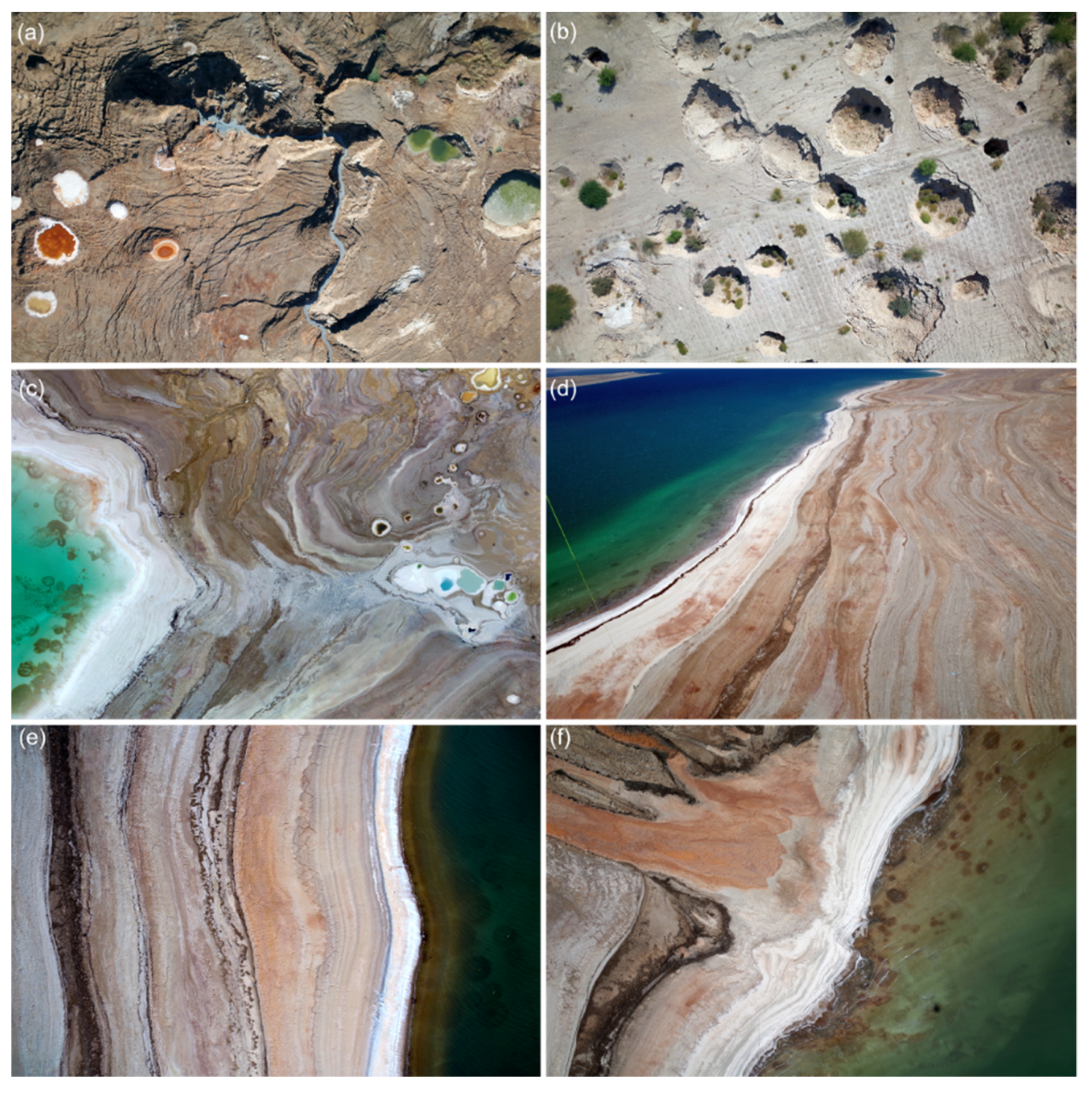
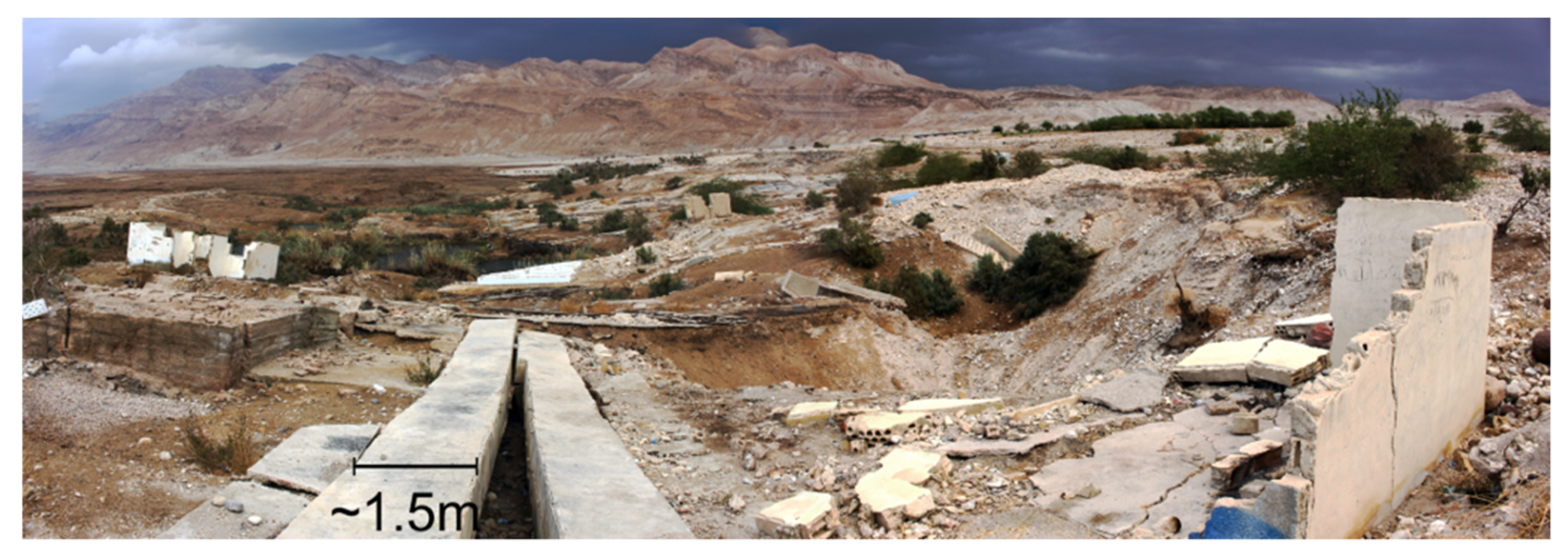
  • There are dangerous zones (Figure 12) prone to collapse (sinkholes, cracks), sinking (mud) or drowning (lakes, ponds) and flash flood risk (wadis). Visit of such zones will only be possible by: (1) experienced guides, (2) during good weather, (3) only in the daytime, (4) with appropriate equipment and (5) along safe (elevated) routes. Therefore, hazard monitoring to define safe zones is an essential part of safeguarding certain areas of the Geopark. An approach is presented in the companion paper [5].
  • During heavy rain events and days after, some parts of the territory will be closed for visitors. A hydrogeophysical monitoring group will be established and will supervise decisions and alarm plans for flash floods. See the companion paper [5].
  • Parts of the former lakebed in the proposed zone are a military border area, and visitor permission may be needed
  • The continuous regression of the lake will expose new flats and shorelines and may alter further the local climate. It would also need a continuous re-assessment and definition of walkways and points of interest.
  • The effect of the progressing DS-Red Sea canal project is unclear concerning the chemistry of the Dead Sea and its evolution. This could be a focus bio-hydrochemistry scientific research project.
  • A UGGp must respect local and national laws relating to the protection of geological heritage. The defining geological heritage sites within a UGGp must be legally protected in advance of any application.
  • Geoconservation and Geotourism are often opposed in a challenging way [87], further enhanced by possible mining-related activities. Recent plans for hydrocarbon exploration [88] in Jordan may lead to discussion in certain areas of the Geopark.
  • The Geopark’s financial sustainability is critical to its success and continuation. Strong local and international partnerships, and investments into infrastructure, along with revenue generated from tourism activities, will be required to assure the project’s long-term success.

5. Conclusions

In this paper, we provided a detailed concept aiming to establish a UNESCO Global Geopark in Jordan within the next 5–10 years. It addresses the cultural, geographical, and natural background of the country and territory and highlights the administrative details and possible drawbacks of the project. The Geopark will encompass the Dead Sea area and its mountainous surroundings and will thematically deal with geohazards driven by hydrogeological changes both from geological, over historical up to recent times. Various promising cultural and geotourism activities and efforts have developed in Jordan during the last decades providing a promising background for this project. We give a first overview of the geosites that are considered significant geological and archaeological highlights that offer unique opportunities for the region. In terms of communication, a participatory procedure by a combined bottom-up and top-down approach will be applied to lay the focus of social and political attention on the enhancement of natural and cultural resources. This will be ensured by sustainable development and holistic management by eco-tourism, education and international research that will add to the visibility of the territory. The establishment of such a new UGGp in the Middle East may not only help to benefit from natural peculiarities towards shared social well-being under community-led efforts but also address the important topics of hazard awareness and resilience of the local population.

Author Contributions

Conceptualization, D.A.-H., investigation, D.A.-H. and O.A.; writing—original draft preparation, D.A.-H., O.A. and L.R.; writing—review and editing, D.A.-H., O.A. and L.R.; visualisation, D.A.-H. and O.A.; supervision, L.R.; project administration, D.A.-H., L.R. All authors have read and agreed to the published version of the manuscript.

Funding

This research was funded by the internal GEOMAR Postdoc seed funding. This research received no external funding.

Institutional Review Board Statement

Not applicable.

Informed Consent Statement

Not applicable.

Data Availability Statement

Not applicable.

Acknowledgments

First we thank the three anonymous reviewers for the fruitful comments and suggestions on improving the paper. We would like to thank Artur Agostinho de Abreu e Sá for the encouragement and advice on the conceptualization of a UNESCO Global Geopark in Jordan. We would like to thank Torsten Dahm, Charlotte Krawczyk, Christian Siebert, and Xavier Comas for the support regarding scientific activities. We appreciate the effort of our Jordanian partners at the Ministry of Energy and Mineral Resources, namely the current minister of energy Saleh Al-Kharabsheh, the previous minister Hala Zawati, Amani Alazam, Nedal Atteyat, Ahmad Gharaibeh, Ghada Shatnawi, all secretary generals and all members of the National Geopark Commission. We are grateful for discussions with Hakim Al-Tamimi and William Al Ajalian. Additional thanks go to colleagues Hussam Alrshdan, Robert Watson, Eoghan Holohan and Rena Meyer for helpful comments and suggestions. Finally, we would like to express our gratitude to the UNESCO Jordan commission for their support, effort, and interest regarding the Geopark project.

Conflicts of Interest

The authors declare no conflict of interest.

References

  1. Farsani, N.T.; Coelho, C.; Costa, C. Geoparks and Geotourism: New Approaches to Sustainability for the 21st Century; Brown Walker Press: Boca Raton, FL, USA, 2011; ISBN 1612335519. [Google Scholar]
  2. UNESCO; IGGP; UGG. Statutes and Guidelines. Available online: http://www.unesco.org/new/fileadmin/MULTIMEDIA/HQ/SC/pdf/IGGP_UGG_Statutes_Guidelines_EN.pdf (accessed on 12 January 2022).
  3. GGN. Geopark Map-Global Network of National Geoparks. Available online: http://www.globalgeopark.org/GeoparkMap/index.htm (accessed on 20 January 2022).
  4. UNESCO. Global Geopark List. Available online: https://en.unesco.org/global-geoparks/list (accessed on 20 January 2022).
  5. Al-Halbouni, D.; Alrabayah, O.; Rüpke, L. A Vision on a UNESCO Global Geopark at the Southeastern Dead Sea in Jordan—How Natural Hazards May Offer Geotourism Opportunities. Under Rev. L. 2022. Available online: https://oceanrep.geomar.de/id/eprint/54899/ (accessed on 20 January 2022).
  6. Shahateet, M.; Partale, K. Jordan’s Tourism Sector Analysis and Strategy for Sectoral Improvement; Deutsche Gesellschaft für Internationale Zusammenarbeit (GIZ) GmbH: Bonn, Germany, 2019. [Google Scholar]
  7. MTA. Jordan Tourism Strategy 2021 to 2025. Ministry of Tourism and Antiquities 2021. Available online: Https://Procurement-Notices.Undp.Org (accessed on 9 February 2022).
  8. RSCN. The Royal Society for Conservation Nature Annual Report; RSCN: Jubaiha, Jordan, 2019. [Google Scholar]
  9. UNESCO. Key Facts and Figures on Jordan. Available online: https://en.unesco.org/system/files/countries/Home/jor_facts_figures.pdf (accessed on 20 January 2022).
  10. Allan, M. Geotourism in Jordan; The University of Jordan, Deanship of Academic Research: Amman, Jordan, 2014. [Google Scholar]
  11. Allan, M.; Dowling, R.; Sanders, D. The Motivations of Geotourists in Jordan. In Proceedings of the Third Global Geotourism Conference Tourism on a Plate: Seeing Destinations Differently, Muscat, Oman, 30 October–1 November 2011; Volume 30. [Google Scholar]
  12. Allan, M. Geotourism: An Opportunity to Enhance Geoethics and Boost Geoheritage Appreciation; Geology Society Special Publication: London, UK, 2015; Volume 419, pp. 25–29. [Google Scholar] [CrossRef]
  13. Dowling, R.; Allan, M. Who Are Geotourists? A Case Study from Jordan. In Handbook of Geotourism; Dowling, R., Newsome, D., Eds.; Edward Elgar Publishing: Cheltenham, UK, 2018; pp. 76–86. ISBN 9781785368851. [Google Scholar]
  14. Wojtowicz, B.; Wojtowicz, P. The Prospects for the Development of Geotourism in the Area of the Wadi Rum Desert. J. Tour. Hosp. Manag. 2016, 4, 1–14. [Google Scholar] [CrossRef] [Green Version]
  15. Dowling, R.K. Geotourism’s Global Growth. Geoheritage 2011, 3, 1–13. [Google Scholar] [CrossRef]
  16. UNESCO. Wadi Mujib UNESCO Proposal. Available online: https://en.unesco.org/Sites/Default/Files/Unesco_global_geopark_intergovernmental_check_2020_english-Mujib.pdf (accessed on 28 March 2022).
  17. MEMR Geological Parks By-Law No. 21, 2021. Ministry of Energy and Mineral Resources. Available online: https://www.memr.gov.jo/Ebv4.0/Root_storage/Ar/Eb_list_page/%D9%86%D8%B8%D8%A7%D9%85_%D8%A7%D9%84%D9%85%D8%AD%D9%85%D9%8A%D8%A7%D8%AA_%D8%A7%D9%84%D8%AC%D9%8A%D9%88%D9%84%D9%88%D8%AC%D9%8A%D8%A9_%D8%B1%D9%82%D9%85_(21)_%D9%84%D8%B3%D9%86%D8%A9_2021.pdf (accessed on 9 February 2022).
  18. MoEnv The National Climate Change Adaptation Plan of Jordan—Ministry of Environment 2021. Available online: http://www.moenv.gov.Jo/Ebv4.0/Root_storage/Ar/Eb_list_page/Final_draft_nap-2021.pdf (accessed on 31 March 2022).
  19. MEMR Jordan Prime Minister Elevates Climate Action Plan to National Priority—Ministry of Energy and Mineral Resources. Available online: http://www.moenv.gov.jo/EN//NewsDetails/JORDAN_PRIME_MINISTER_ELEVATES_CLIMATE_ACTION_PLAN_TO_NATIONAL_PRIORITY (accessed on 10 February 2022).
  20. Levy, Y.; Shalev, E.; Burg, A.; Yechieli, Y.; Gvirtzman, H. Three-Dimensional Configuration and Dynamics of the Fresh—Saline Water Interface near Two Saline Lakes with Different Levels (Middle East). Hydrogeol. J. 2021, 29, 1785–1795. [Google Scholar] [CrossRef]
  21. ICL. Dead Sea Water Level—ICL. Available online: https://icl-group-sustainability.com/reports/dead-sea-water-level/ (accessed on 13 January 2022).
  22. Gavrieli, I.; Stein, M. On the Origin and Fate of the Brines in the Dead Sea Basin. In New Frontiers in Dead Sea Paleoenvironmental Research; Geology Society America: Boulder, CO, USA, 2006; Volume 401, pp. 183–194. [Google Scholar]
  23. Yechieli, Y.; Reznik, I.J.; Tal, A.; Netzer, L.; Livshitz, Y.; Stein, S. General Information and Hydrogeology of the Mediterranean and Dead Sea Coastal Aquifers and Their Relation with Their Base Level. In The Many Facets of Israel’s Hydrogeology; Springer: Cham, Switzerland, 2021; pp. 31–48. [Google Scholar]
  24. Al Kuisi, M.; Abed, A.M.; Mashal, K.; Saffarini, G.; Saqhour, F. Hydrogeochemistry of Groundwater from Karstic Limestone Aquifer Highlighting Arsenic Contamination: Case Study from Jordan. Arab. J. Geosci. 2015, 8, 9699–9720. [Google Scholar] [CrossRef]
  25. Salameh, E. The Hydrogeological Consequences of the Proposed Extraction of the Deep Groundwater in Jordan. J. Geosci. Environ. Prot. 2021, 9, 111–128. [Google Scholar] [CrossRef]
  26. Ababsa, M. Atlas of Jordan; Ababsa, M., Ed.; Institutes Francais du Proche Orient: Beyrouth, Lebanon, 2013; ISBN 9782351593783. [Google Scholar]
  27. Nissenbaum, A. The Dead Sea—An Economic Resource for 10 000 Years. Hydrobiologia 1993, 267, 127–141. [Google Scholar] [CrossRef]
  28. USGS. Landsat Images from USGS. Available online: https://earthshots.usgs.gov/earthshots/ (accessed on 20 January 2022).
  29. ArcGIS. World Imagery Database. Available online: https://www.arcgis.com/home/item.html?id=10df2279f9684e4a9f6a7f08febac2a9 (accessed on 31 March 2022).
  30. Willner, S.E.; Lipchin, C.; Aloni, Z. Salt Storms, Sinkholes and Major Economic Losses: Can the Deteriorating Dead Sea Be Saved from the Looming Eco Crisis? Negev. Dead Sea Arav. Stud. 2015, 7, 27–37. [Google Scholar]
  31. Abou Karaki, N.; Fiaschi, S.; Closson, D. Sustainable Development and Anthropogenic Induced Geomorphic Hazards in Subsiding Areas. Earth Surf. Process. Landf. 2016, 41, 2282–2295. [Google Scholar] [CrossRef]
  32. Al-Halbouni, D.; Holohan, E.P.; Saberi, L.; Alrshdan, H.; Sawarieh, A.; Closson, D.; Walter, T.R.; Dahm, T. Sinkholes, Subsidence and Subrosion on the Eastern Shore of the Dead Sea as Revealed by a Close-Range Photogrammetric Survey. Geomorphology 2017, 285, 305–324. [Google Scholar] [CrossRef] [Green Version]
  33. Ezersky, M.G.; Legchenko, A.; Eppelbaum, L.; Al-Zoubi, A.S. Overview of the Geophysical Studies in the Dead Sea Coastal Area Related to Evaporite Karst and Recent Sinkhole Development. Int. J. Speleol. 2017, 46, 277–302. [Google Scholar] [CrossRef] [Green Version]
  34. Shviro, M.; Haviv, I.; Baer, G.G. High-Resolution InSAR Constraints on Flood-Related Subsidence and Evaporite Dissolution along the Dead Sea Shores: Interplay between Hydrology and Rheology. Geomorphology 2017, 293, 53–68. [Google Scholar] [CrossRef]
  35. Abou Karaki, N.; Fiaschi, S.; Paenen, K.; Al-Awabdeh, M.; Closson, D. Exposure of Tourism Development to Salt Karst Hazards along the Jordanian Dead Sea Shore. Hydrol. Earth Syst. Sci. 2019, 23, 2111–2127. [Google Scholar] [CrossRef] [Green Version]
  36. Khodayar, S.; Hoerner, J. An Idealized Model Sensitivity Study on Dead Sea Desertification with a Focus on the Impact on Convection. Atmos. Chem. Phys. 2020, 20, 12011–12031. [Google Scholar] [CrossRef]
  37. TG Flash Flood in Jordan Sweeps Away School Bus, Killing at Least 18, The Guardian. Available online: https://www.theguardian.com/world/2018/oct/25/flash-flood-in-jordan-sweeps-away-school-bus-killing-children (accessed on 5 January 2022).
  38. Closson, D.; Hansen, H.; Halgand, F.; Milisavljevic, N.; Hallot, F.; Acheroy, M. The Red Sea–Dead Sea Canal: Its Origin and the Challenges It Faces. In Macro-Engineering Seawater in Unique Environments; Badescu, V., Cathcart, R.B., Eds.; Environmental Science and Engineering; Springer: Berlin/Heidelberg, Germany, 2011; pp. 107–124. ISBN 978-3-642-14778-4. [Google Scholar]
  39. GOJ. Jordan Red Sea Project Description; Government of Jordan: Amman, Jordan, 2011; Available online: Https://Www.Scribd.Com/Document/96081097/JRSP-Project-Description (accessed on 9 February 2022).
  40. El-Anis, I.; Smith, R. Freshwater Security, Conflict, and Cooperation: The Case of the Red Sea-Dead Sea Conduit Project. J. Dev. Soc. 2013, 29, 1–22. [Google Scholar] [CrossRef]
  41. JT. 5 Alliances Shortlisted to Execute Red-Dead’s Phase I. Available online: http://www.jordantimes.com/news/local/5-alliances-shortlisted-execute-red-dead’s-phase-i (accessed on 12 January 2022).
  42. JT. Water Ministry Proceeds with Amman-Aqaba Water Desalination Project. Available online: https://www.jordantimes.com/news/local/water-ministry-proceeds-amman-aqaba-water-desalination-project (accessed on 12 January 2022).
  43. UN Transforming Our World: The 2030 Agenda for Sustainable Development. United Nations. Gen. Assem. Resolut. A/RES/70/1 2015. Available online: Https://Sustainabledevelopment.Un.Org (accessed on 9 February 2022).
  44. Putayeva, E. Different Approaches to the Formation of Geoparks. Acta Geoturistica 2014, 5, 69–80. [Google Scholar] [CrossRef]
  45. Jose, B. Geoconservation and Protected Areas. Environ. Conserv. 2002, 29, 273–276. [Google Scholar] [CrossRef] [Green Version]
  46. Union for the Mediterranean. Jordanian Railway Network. 2017. Available online: https://ufmsecretariat.org./Wp-Content/Uploads/2017/12/TUD-Jordanian-Railway_EN.pdf (accessed on 9 February 2022).
  47. Worldbank Jordan—Climatology. Available online: https://climateknowledgeportal.worldbank.org/country/jordan/climate-data-historical (accessed on 5 January 2022).
  48. Bender, F. Geology of Jordan; Schweizerbart’sche Verlagsbuchhandlung: Stuttgart, Germany, 1974. [Google Scholar]
  49. Pollastro, R.M.; Karshbaum, A.S.; Viger, R.J. Maps Showing Geology, Oil and Gas Fields and Geologic Provinces of the Arabian Peninsula; U.S. Geological Survey Open-File Report 97-470-B; U.S. Geological Survey: Reston, VA, USA, 1999; 14p. [Google Scholar]
  50. Garfunkel, Z.; Ben-Avraham, Z. The Structure of the Dead Sea Basin. Tectonophysics 1996, 266, 155–176. [Google Scholar] [CrossRef]
  51. El-Hasan, T.; Abu-Jaber, N. Geochemistry, Mineralogy and Origin of the Shallow Water Sediments Collected along the Eastern Shore of the Northern Part of the Dead Sea. Carbonates Evaporites 2018, 34, 975–985. [Google Scholar] [CrossRef]
  52. Khoury, H.N. Clays and Clay Minerals in Jordan; Deanship of Scientific Research: Amman, Jordan, 2002. [Google Scholar]
  53. Garber, R.A.; Friedman, G.M. The Sedimentology of the Dead Sea. Carbonates Evaporites 1987, 2, 43–57. [Google Scholar] [CrossRef]
  54. Kerp, H.; Blomenkemper, P.; Hamad, A.A.B.U.; Bomfleur, B. The Fossil Flora of the Dead Sea Region, Jordan—A Late Permian Garden of Delights. J. Palaeosci. 2021, 70, 135–158. [Google Scholar]
  55. Kumaraswamy, P.R. The Palgrave Handbook of the Hashemite Kingdom of Jordan; Springer: Berlin/Heidelberg, Germany, 2019; ISBN 9811391661. [Google Scholar]
  56. Clark, G.A.; Coinman, N.R.; Hill, J.B.; Neeley, M.P.; Olszewski, D.I.; Peterson, J.D.; Schuldenrein, J. Survey and Excavation of Stone Age Sites in Jordan’s Wadi Al-Hasa: 1979–2012. In Quaternary of the Levant: Environments, Climate Change, and Humans; Bar-Yosef, O., Enzel, Y., Eds.; Cambridge University Press: Cambridge, UK, 2017; pp. 315–328. ISBN 9781107090460. [Google Scholar]
  57. Werner, B. Al Karak Castle. Available online: https://upload.wikimedia.org/wikipedia/commons/0/08/Kerak_BW_1.JPG (accessed on 31 March 2022).
  58. Al’ain, A. Sanctuary of Lot. Available online: https://de.m.wikipedia.org/wiki/Datei:Sanctuary_of_Lot_02.jpg (accessed on 31 March 2022).
  59. Thomas Bantle Machaerus Panorama. Available online: https://upload.wikimedia.org/wikipedia/commons/b/b2/Machaerus_Panorama.jpg (accessed on 31 March 2022).
  60. Gagnon, B. Montreal Castle. Available online: https://upload.wikimedia.org/wikipedia/commons/6/65/Montreal_Castle_Visitor_center.jpg (accessed on 31 March 2022).
  61. Ryan, C.R. Hashemite Kingdom of Jordan. In The Government and Politics of the Middle East and North Africa; Yom, S.L., Gasiorowski, M., Eds.; Westview Press: Boulder, CO, USA, 2017. [Google Scholar]
  62. WPR. Population of Cities in Jordan, World Population Review. Available online: https://worldpopulationreview.com/countries/cities/jordan (accessed on 5 January 2022).
  63. El-Naqa, A. Hydrological and Hydrogeological Characteristics of Wadi El Mujib Catchment Area, Jordan. Environ. Geol. 1993, 22, 257–271. [Google Scholar] [CrossRef]
  64. Al-Halbouni, D.; Alrabayah, O.; Rüpke, L. Vision on a UNESCO Global Geopark at the Southeastern Dead Sea, Jordan. In Proceedings of the Digital 9th International Conference on UNESCO Global Geoparks, GGN, Jeju Island, Korea, 12–16 December 2021. [Google Scholar]
  65. Costa, M.P.; Meneses, S.; Nunes, J.C. Geo-Urban Routes as a Powerful and Easily Available Educational Resource—Case of Angra Do Heroísmo City in Azores UGGp. In Proceedings of the Digital 9th International Conference on UNESCO Global Geoparks, Jeju Island, Korea, 12–16 December 2021. [Google Scholar]
  66. Martins, J.S.; Pintalssilgo, A.; Mories, A.; Araújo, A.; Veiga-Pires, C. Geopalcos: Art, Science and Nature as Instruments of Cohesion and Promotion of the Aspiring Geopark Algarvensis Territory. In Proceedings of the Digital 9th International Conference on UNESCO Global Geoparks, Jeju Island, Korea, 12–16 December 2021. [Google Scholar]
  67. Sá, A.A.; Rosado-González, E.; Silva, E. Five Years of the UNESCO Chair on Geoparks, Regional Sustainable Development, and Healthy Lifestyles—Changing the World Through Education. In Proceedings of the Digital 9th International Conference on UNESCO Global Geoparks, Jeju Island, Korea, 12–16 December 2021. [Google Scholar]
  68. Goyanes, G.; Vieira, G.; Soncco, C.; De Castro, E. 3D Modelling Of Geosites—From Surveying To Outreach. In Proceedings of the Digital 9th International Conference on UNESCO Global Geoparks, Jeju Island, Korea, 12–16 December 2021. [Google Scholar]
  69. Soncco, C.; Vieira, G.; Goyanes, G.; De Castro, E. Ultra-High Resolution Maps and Models as Tools for Managing and Monitoring Environmentally Sensitive Geosites (Estrela Geopark, Portugal). In Proceedings of the Digital 9th International Conference on UNESCO Global Geoparks, Jeju Island, Korea, 12–16 December 2021. [Google Scholar]
  70. Al-Halbouni, D.; Watson, R.A.; Holohan, E.P.; Meyer, R.; Polom, U.; Santos, F.M.; Comas, X.; Alrshdan, H.; Krawczyk, C.M.; Dahm, T. Dynamics of Hydrological and Geomorphological Processes in Evaporite Karst at the Eastern Dead Sea—A Multidisciplinary Study. Hydrol. Earth Syst. Sci. 2021, 25, 3351–3395. [Google Scholar] [CrossRef]
  71. Williams, M.A.; McHenry, M.T. Tasmanian Reserve Geoconservation Inventory Assessment Using Geographic Information Technology (GIT). Int. J. Geoheritage Park. 2021, 9, 294–312. [Google Scholar] [CrossRef]
  72. Kitsaki, G.; Papaioannou, H. New Technologies in the Service and Promotion of Geological, Natural and Cultural Heritage. In Proceedings of the Digital 9th International Conference on UNESCO Global Geoparks, Jeju Island, Korea, 12–16 December 2021. [Google Scholar]
  73. Williams, M.A.; McHenry, M.T. The Increasing Need for Geographical Information Technology (GIT) Tools in Geoconservation and Geotourism. Geoconserv. Res. 2020, 3, 17–32. [Google Scholar] [CrossRef]
  74. Rodrigues, J.; Duarte, A.; Costa, M.P.; Morais, A.; Castro, E. Geotourism Strategy in Portuguese UNESCO Global Geoparks. In Proceedings of the Digital 9th International Conference on UNESCO Global Geoparks, Jeju Island, Korea, 12–16 December 2021. [Google Scholar]
  75. Oliveira, S.; Moura, D.; Pereira, L.; Veiga-Pires, C. Promoting Geosites In The Community—The Escarpão Plateau (South of Portugal). In Proceedings of the Digital 9th International Conference on UNESCO Global Geoparks, Jeju Island, Korea, 12–16 December 2021. [Google Scholar]
  76. Lugeri, F.R.; Farabollini, P.; Greco, R.; Amadio, V. The Geological Characterization of Landscape in Major TV Series: A Suggested Approach to Involve the Public in the Geological Heritage Promotion. Sustainability 2015, 7, 4100–4119. [Google Scholar] [CrossRef] [Green Version]
  77. Department of Statistics. Jordan Statistical Yearbook 2020; DoS: Amman, Jordan, 2021.
  78. World Bank Population Growth Indicator 2021. Available online: https://data.worldbank.org/indicator/SP.POP.GROW?end=2020&locations=JO&start=1961&view=chart (accessed on 9 February 2022).
  79. Kumaraswamy, P.R.; Singh, M. Population Pressure in Jordan and the Role of Syrian Refugees. Migr. Dev. 2017, 6, 412–427. [Google Scholar] [CrossRef]
  80. Salameh, E.; Al-Ansari, N. Deficient Developmental Planning Leading to Water Conflicts across Political Borders: The Way Forward. Engineering 2021, 13, 158–172. [Google Scholar] [CrossRef]
  81. Brückner, F.; Bahls, R.; Alqadi, M.; Lindenmaier, F.; Hamdan, I.; Alhiyari, M.; Atieh, A. Causes and Consequences of Long-Term Groundwater Overabstraction in Jordan. Hydrogeol. J. 2021, 29, 2789–2802. [Google Scholar] [CrossRef]
  82. Al-Ansari, N.; Alibrahiem, N.; Alsaman, M.; Knutsson, S. Water Demand Management in Jordan. Engineering 2014, 6, 19–26. [Google Scholar] [CrossRef] [Green Version]
  83. Fallatah, O.A.; Ahmed, M.; Save, H.; Akanda, A.S. Quantifying Temporal Variations in Water Resources of a Vulnerable Middle Eastern Transboundary Aquifer System. Hydrol. Process. 2017, 31, 4081–4091. [Google Scholar] [CrossRef]
  84. Salameh, E.; Shteiwi, M.; Al Raggad, M. Water Resources of Jordan: Political, Social and Economic Implications of Scarce Water Resources; Springer: Berlin/Heidelberg, Germany, 2018; Volume 1, ISBN 3319777483. [Google Scholar]
  85. Loureiro, F.; Castro, E. Geoconservation in the Estrela UNESCO Global Geopark. In Proceedings of the Digital 9th International Conference on UNESCO Global Geoparks, Jeju Island, Korea, 12–16 December 2021. [Google Scholar]
  86. Skibiński, J.; Kultys, K.; Baran-Zgłobicka, B.; Zgłobicki, W. Geoparks in SE Poland as Areas of Tourism Development: Current State and Future Prospects. Resources 2021, 10, 113. [Google Scholar] [CrossRef]
  87. Williams, M.A.; McHenry, M.T.; Boothroyd, A. Geoconservation and Geotourism: Challenges and Unifying Themes. Geoheritage 2020, 12, 63. [Google Scholar] [CrossRef]
  88. MEMR. Oil & Gas Exploration Opportunities in Jordan; Ministry of Energy and Mineral Resources: Amman, Jordan, 2021.
Figure 1. Map of topography, main morphological units and geotouristic attractions of the Hashemite Kingdom of Jordan, edited with the proposed Geopark location at the southern Dead Sea in its final extent. A selection of the main touristic attractions in Jordan is given: (1) Aqaba, (2) Wadi Rum, (3) Petra, (4) Shoubak, (5) Fynan, (6) Al-Karak, (7) Madaba, (8) Iraq Al-Amir, (9) Baptism Site, (10) Ajloun, (11) Pella, (12) Umm Qays, (13) Jerash, (14) Umm Al-Jimal, (15) Qasr Al-Hallabat, (16) Quseir Amra, (17) Quasr Al-Azraq, (18) Quasr Al-Mushatta, (19) Quasr Al-Kharrana, (20) Umm Ar-Rasas, (21) Ghor Al-Haditha sinkhole site and (22) Dead Sea (DS).
Land 11 00549 g001
Figure 2. Satellite images of the Dead Sea area. A recession of the shoreline and the separation into a Northern Dead Sea body and the evaporation pond body is clearly visible between 1973 and 2017. Yellow circles mark a selection of the most important sites with known natural hazards such as sinkholes and strong erosion/flash floods on both sides of the Dead Sea, approximate locations are based on [31,32,33]. These are: (1) Ghor Al-Haditha, the highlgiht area of the proposed Geopark; (2) Lisan Peninsula; (3) Arab Potash company and Dead Sea works; (4) Newe Zohar and Ein Boqeq; (5) Lynch Strait; (6) Nahal Zeelim; (7) Ein Gedi to Nahal Hever; (8) Dragot to Mineral Beach, (9) Zikim, (10) Touristic complex Sweimeh, (11) Wadi Ma’in and (12) Wadi Mujib. Landsat satellite images have spatial resolutions of 60 m/px before the year 2000 and 30 m/px thereafter [28].
Land 11 00549 g002
Figure 3. Overview map of the proposed Geopark aerial extent. Two extension phases are suggested for the creation.
Land 11 00549 g003
Figure 4. Geological map of the surroundings of the aspiring Geopark. It shows the bedrock geology and fault system. Note that background geology and shorelines are based on USGS database Geologic Map of the Arabian Peninsula from 1963 and UNESCO database Geologic Map of Europe from 1971 (see references within [48], as available in ArcGIS). The Dead Sea hence is at its extent before regression. Faults are based on [26,48,49] and only at approximate positions.
Land 11 00549 g004
Figure 5. Preliminary logo of the Dead Sea Geopark in Jordan.
Land 11 00549 g005
Figure 6. Geographic map with highlight features of the surroundings of the aspiring Geopark. It shows the location of the main geological/natural and archaeological/cultural features of international significance. These are listed in Table 1. Background is an ArcGIS satellite basemap from the World Imagery database with resolution between 15 and 2.5 m/px [29].
Land 11 00549 g006
Figure 7. Aerial photos of the Geopark highlight area (G0). These show (a) recent canyons and colourful sinkholes depending on mineral content, (b) deep and nested karst sinkhole features on former agricultural ground, (c) Colourful sinkholes with drainage into the Dead Sea and shallow water salt formations, (d) record of yearly retreating shorelines with different types of evaporites, (e) regression of the Dead Sea with sedimentation and evaporation, and (f) stream-channel discharge systems with offshore salt concretions and submarine springs. All photos were taken by a drone or balloon controlled by Djamil Al-Halbouni, Eoghan Holohan and Robert Watson.
Land 11 00549 g007
Figure 8. Rocks, minerals, fossils, and erosive structures at the aspiring Geopark area. (a) Bioturbation in limestone, (b,c) sculpture-like limestones, (d) shell deposits, (e) sulphur precipitation and (f) sintering. All photos were taken by Djamil Al-Halbouni.
Land 11 00549 g008
Figure 9. Impression of wadis in the area (i.e., ephemeral streams). (a) Wadi Mutayl, (b) Wadi Ibn Hamad, (c,d) Wadi Hidan/Waleh in Wadi Mujib Nature Reserve, (e) Lower Waterfall Wadi Mujib, (f) Wadi Al-Hasa Siq, (g) Barta waterfall Wadi Hidan. Photos (a,b) were taken by Djamil Al-Halbouni, photos (cg) by Osama AlRabayah.
Land 11 00549 g009
Figure 11. Preliminary timeline for implementation of the Geopark.
Land 11 00549 g011
Figure 12. The impact of the sinkhole hazard near the shoreline. Photo taken by Djamil Al-Halbouni, modified after [70].
Land 11 00549 g012
Table 1. List of geological/ecological and cultural/archaeological heritage inside the proposed Geopark area.
Geological/Ecological (G)Short DescriptionArchaeological/Cultural (A)Short Description
G0Highlight area–sinkholes and subsidence at Ghor Al-Haditha, Dead Sea shorelineA0Evaporation ponds–Arab Potash Factory
G1Wadi Mujib Reserve and waterfallsA1Bab edh-Dhra archaeological site of Bronze Age, Wadi Al-Hasa
G2Wadi Mujib canyon up to the plateau (Wadi Hidan/Waleh)A2Al-Karak, historical city and archaeological remains (crusader castle)
G3a, bWadi Mujib canyon (a) up to the plateau (dam, b) Western Highlands range mountains, valleys and springsA3a–eLimes Arabicus–archaeological remains of roman origin, i.e., Umm Al-Rasas (a), Betthorus (b), Quasr Abu Rukba (b), Khirbet el-Fityan (b), Rujm el-Faridiyyeh (b), Quasr Bshir (c), Qasr Abu el-Kharaq (c), Umm Ubtulah (d), and Qasr Dajaniya (e).
G4Wadi Ibn Hamad and hot springsA4Numeira archaeological site of Bronze Age
G5Wadi Mutayl/Al Karak and Mumia fallsA5Ghor As-Safi museum of the lowest place on Earth, Lot’s Cave byzantine basilica
G6Wadi AssalA6Khirbet et-Tannur archaeological remains of Nabatean origin
G7Wadi NumeiraA7Khirbet ed-Dharih archaeological remains of Nabatean origin
G8Wadi Al-HasaA8At-Tafilah historical city and Sela castle from Edom kingdom
G9Afra hot springsA9Khirbat en-Nahas Bronze age copper mine
G10Wadi Dana and Dana Biosphere ReserveA10Shobak crusader castle-Montreal
G11Wadi Ma’in Hot springsA11Dead Sea Panoramic Complex
Table 2. List of larger communities inside or in proximity of the proposed Geopark area.
WestCentreEastOutside
Ghor Al-HadithaAl-MughayerAl-QuatranaShobak
Ghor Al-Mazra’aAl-KarakJurf Ed-DarawishDhiban
Ghor As-SafiAt-TafilahHasaAl-Husainya
FeifaDana
Al-Qasr
Table 3. List of potential geotouristic activities and infrastructure in the proposed Geopark area.
Site NameAreaInformationActivities
Mujib Adventure CentreDead SeaThe RSCN runs and manages the centre, which provides visitors with information on the Mujib biosphere reserve, including its geological history. The facility also offers a range of tourism activities.Hiking, accommodations, local crafts, and educational programs.
Alhidan Adventures CentreMadabaThe RSCN manages the property, which is administered by the local community. The facility offers a variety of hiking paths in the Mujib biosphere reserve’s western region.Hiking tours.
Alhidan Camp SiteMadabaThe property is owned and operated by the local community and is located on the eastern outskirts of the Mujib Biosphere Reserve.Accommodation.
Al Numeira Environmental
Association
Ghor Al-Mazra’aThe association is operated and administered by local communities in the region, with the goal of addressing environmental issues and encouraging a more sustainable way of life in the Southern Ghor region. The Association provides various tourism activities and lodging in order to generate sustainable revenue for the association and to provide jobs for the local populations.Educational programs, local crafts, biking, and hiking tours.
Shallalat Mumia Cooperative SocietyAl-KarakThe Society offers a variety of tourism activities in Wadi Al-Karak as a means of generating income, creating jobs, and capacity building in the local communities.Hiking tours, accommodation, and educational programs.
Feynan EcolodgeWadi ArabaThe lodge is privately operated, and it offers a variety of tourism activities in the Dana Reserve’s western region. The lodge employs people from the surrounding area.Hiking tours accommodation and educational programs.
Table 4. List of potential national level partners in Jordan (not in order of importance, not exclusive).
NoNameFocus
1Jordan Tourism Board (JTB)Utilize marketing strategies to brand, position and promote the Jordan tourism product as the destination of choice in the international markets. This can facilitate the promotion of the Geopark as a unique tourism destination.
2Jordanian Ministry of Tourism and AntiquitiesTo promote and develop tourism and to invest in tourism resources in order to increase its contribution to supporting the national economy and spreading understanding among people. The ministry will be an essential partner for the development and promotion of tourism activities within the Geopark.
3Ministry of Environment (MoEnv)The ministry’s core role is protecting and sustaining the environment and all of its components, including air, water, and soil, through developing legal, strategic and policy frameworks in addition to spreading environmental culture and enhancing environmental monitoring and law enforcement in Jordan. The ministry will be the main partner for the development of a conservation and protection plan for the Geopark.
4The Jordan Valley Authority (JVA)As part of the Ministry of Water and Irrigation (MWI), JVA is concerned with the management and development of water resources and land in the Jordan Valley including the Southern Ghor region.
5Local municipality, and educational directorate of Al-Karak, Altafileh and MadabaPromoting educational activities within the Geopark and facilitating the work and implementation of the laws within the area.
6Royal Society for the Conservation of Nature (RSCN)Nature protection and the establishment and management of
nature reserves. Implementation of the protection program and the law of hunting. The RSCN are managing the conservation and tourism activities in Dana Biosphere Reserve, Fifa Nature Reserve and Mujib Nature Reserve.
7Jordan Trail Association (JTA)The association aim to develop and maintain the Jordan trail (a long-distance hiking trail that crosses Jordan north most to south most and passes through different regions within the proposed Geopark) and to support and build the capacity of local communities that the trail passes through.
Table 5. List of potential local NGO partners in Jordan (not in order of importance, not exclusive).
NoNameFocus
6Al Numeira Environmental AssociationPromote water conservation and sustainable living in the Dead Sea area by educating the local community about environmental issues. The Association operates a small visitor centre in Ghor Al-Numeira.
7Dana Cooperative The cooperative’s goals include the preservation of Dana village, community development, and the empowerment of local women and youth. The cooperative aims at creating community-owned, sustainable tourism in Dana Nature Reserve.
8Mumia Falls Cooperative OrganisationThe Organisation aims to develop environmental tourism, support the economic style of the local community, enhance its ownership of its resources, and harness its traditional knowledge for the service of residents and visitors at Wadi Al-Karak area.
9Al-Karak Creativity ClubThe club is involved in the development and promotion of ecotourism within Al-Karak governorate.
10Rakin Women’s SocietyWomen’s empowerment through increased economic engagement in Wadi Ibn Hammad area. The Society operates a number of revenue-generating tourism projects.
11OtherPrivate persons, companies, (e.g., Arab Potash Factory) and other touristic initiatives (e.g., cultech.net)
Publisher’s Note: MDPI stays neutral with regard to jurisdictional claims in published maps and institutional affiliations.

