Article

A Vision on a UNESCO Global Geopark at the Southeastern Dead Sea in Jordan—How Natural Hazards May Offer Geotourism Opportunities

1
Dynamics of the Ocean Floor, Seafloor Modelling Group, GEOMAR Helmholtz Centre for Ocean Research, Wischhofstrasse 1–3, 24148 Kiel, Germany
2
Marine Biochemistry, Ocean Machine Vision Group, GEOMAR Helmholtz Centre for Ocean Research, Düsternbrooker Weg 20, 24105 Kiel, Germany
*
Author to whom correspondence should be addressed.
Land 2022, 11(4), 553; https://doi.org/10.3390/land11040553
Submission received: 28 February 2022 / Revised: 29 March 2022 / Accepted: 31 March 2022 / Published: 9 April 2022
(This article belongs to the Special Issue Geoparks as a Form of Tourism Space Management)

Abstract

:
This paper aims to identify and discuss the chances, solutions, and possible drawbacks related to the establishment of safe geotourism sites in subsidence-affected areas, exemplarily applied to the Ghor Al-Haditha sinkhole site at the southeastern shore of the Dead Sea. Such safe areas shall be established in the territory of the proposed future UNESCO Global Geopark (UGGp) in Jordan. The highlights of the geopark and the basis of its creation are the subsidence features and stream channels found along the SE shoreline of the Dead Sea, which form both a natural hazard and geological heritage of high international significance and have attracted many researchers so far. This recent and ongoing formation is related to the sharp regression of the lake, the specific geomechanical conditions, and the hydrogeologic and climatic background of the surroundings. Nearby communities have suffered in economic terms from these natural phenomena, including flash floods and droughts in this semi-arid to arid region. We here present a concept on how to integrate geoscientific research for hazard monitoring and early warning to maintain safety for inhabitants and visitors on the one hand and reach sustainable economic development through the establishment of geotourism sites on the other hand. This highlight area of the proposed UGGp serves as a starting example for delineating safe zones for walkways and infrastructure. This involves two-way knowledge transfer between spatial planning and hydrogeophysical monitoring, a network of community-supported geophysical surveillance, and regular maintenance and adaptation. The cross-cutting benefits for the territory involve the delineation of safe areas for agriculture and geotourism, the increase of sustainable tourism in the region with a shift towards alternative ways of income, more investment in infrastructure, a growth of international visibility of the region, enhanced environmental education with focus on responsible water usage, and involvement in international research and education projects.

1. Introduction

UNESCO Global Geoparks (UGGps) are unified geographical areas with designated natural features of international geologic significance that are managed by a holistic concept of protection, education, and sustainable development [1]. Their main focus areas are natural resources, climate change, education, science, culture, women, local and indigenous knowledge, sustainable development, and geological hazards [2]. The latter has gained increasing attention in the geopark community with dedicated working groups, webinars in recent years and upcoming conferences [3,4,5,6]. There is a growing number of UGGps worldwide that are located in geographic territories exposed to geological and hydrometeorological hazards [7].

1.1. Global Geoparks in Natural Hazard Areas

Naturally, many geoparks contain areas that are often affected by an interplay of various natural hazards. Examples of occasional hazards are earthquakes in active seismic areas such as almost all geoparks in Taiwan [8], volcanic activity and eruption such as that in Unzen [9] and Katla UGGp [10], and the risk of tsunamis mainly in the SE Asian geoparks. More frequent are hazards related to flooding, drought and desertification (e.g., in the UGGp Cilento [11], Queshm [12], Araripe [13], or Burren and Cliffs of Moher [14]), intensified by climate change [15]. Dynamic changes of the hydrogeological system can trigger geohazards such as landslides, rockfalls, mud and debris flow (e.g., at the Luochuan Loess Geopark [16]).
In addition to the threat that geohazards pose to the population, visitors and infrastructure, and the restrictions related to economic investment and development, geohazards also constitute challenges for management of geoparks. A proper environmental monitoring of areas prone to natural hazards has to be assured in order to provide safety. An inventory and changes of the individual geological units have to be thoroughly recorded; for example, rock debris that may create sudden water dams. A quick reaction must be enabled, protective measures must be taken such as the closure during flash flood events in Queshm UGGp [12], and communication channels must exist between the different bodies of the geopark management.
However, geohazards are partly even considered as a negative stimulant in order to initiate geotourism and education opportunities [8,17]. After the Tohoku 2011 earthquake and subsequent catastrophe, the Global Geopark Network (GGN) adapted the “Shimbara” declaration [18] to work on a global scale for disaster risk reduction by means of education, networking, knowledge exchange, conservation, and sustainable use of geoheritage, and collaboration with territorial and international bodies and communities [7]. Thus, establishing a UGGp in geohazard areas may help in mitigating negative effects in various ways: geoparks can act as living laboratories to mitigate risk and raise awareness [7]. From past geohazards such as the flooding and landslides in the Apuane Alps in Italy [17], communities have benefited by the establishment of educational facilities in the framework of a geopark, i.e., learning by understanding past events. Creating resilience in the population by identification of the geological elements and abilities needed to react to the changes is the major key that can be transferred into suitable disaster response strategies. Geoparks can improve and intensify the communication between different channels—society, politicians, and scientists—in order to provide knowledge and skill transfer [19]. Finally, the community itself acts as a stimulator for disaster mitigation and risk management. Groups on geohazards and geoheritage, for example, the working group on geohazards from the GGN [6], will bring the geopark community closer together to find and adapt suitable strategies, to offer training to the local inhabitants and stakeholders, and to assess the vulnerability and raise the preparedness of the territory for all kinds of geohazards.
The purpose of this study was to provide a plan on how to address the dynamic subsidence, sinkhole, and flash flood hazard in the proposed geopark territory in Jordan, in order to enable a senseful spatial planning based on risk management from the beginning of the project. We aim at using well-established geophysical and hydrogeological monitoring methods together with up-to-date remote sensing techniques in order to provide a geohazard assessment and realistic planning of geotourism opportunities. Besides the technical background, and discussion of the expected outcomes regarding a suitable warning system, we also provide essential information for communication planning between the different entities of the territory. In a companion paper [20], we discuss the concepts, general challenges and chances to establish a UGGp in Jordan, southeast of the Dead Sea. The envisioned geopark comprises a major part of the lake and adjacent parts of the Eastern Rim Highlands and extends up to the desertic plateau. The overall theme of the UGGp is the interplay between hydrogeology and geomorphology and its effect on the local communities from historical to recent times. As the area is subject to strong natural hazards related to water flow, there is a need for environmental monitoring and hazard mitigation plans for some parts of the geopark. This paper presents such concepts using the proposed highlight area of the UGGp, the sinkhole and subsidence area of Ghor Al-Haditha (GAH) at the southeastern shore of the Dead Sea, as an example.

1.2. Hydrogeologic Hazards in the Surroundings of the Dead Sea

At the Dead Sea (DS, Figure 1a), coastal erosion occurs at an unprecedented rate. It poses a significant threat to the local population and infrastructure, with high economic losses on both sides of the lake [21]. Scientifically, the unique geological setting of the area has allowed for major advances in natural hazard and subsidence research throughout the past decade [22,23,24,25,26]. Subsidence in this region occurs at three different scales, from regional-scale near-shore subsidence due to mechanical compaction driven by groundwater decline, over large-scale depression formation (uvalas) due to widespread subsurface water flow and material removal, up to small-scale sinkhole formation within these uvalas due to focused flow [23,24].
These subsidence patterns result from complex hydromechanical feedbacks between changing fluid pathways, surface deformation and erosion, and the formation of fluid escape structures under continuously varying conditions such as connections between the on- and offshore hydraulic systems. For researchers, the DS is therefore an excellent study site, where interactions between hydrological and geomorphological processes can be studied, and the knowledge gained can be transferred to other on- and offshore analogues [27,28,29,30,31].

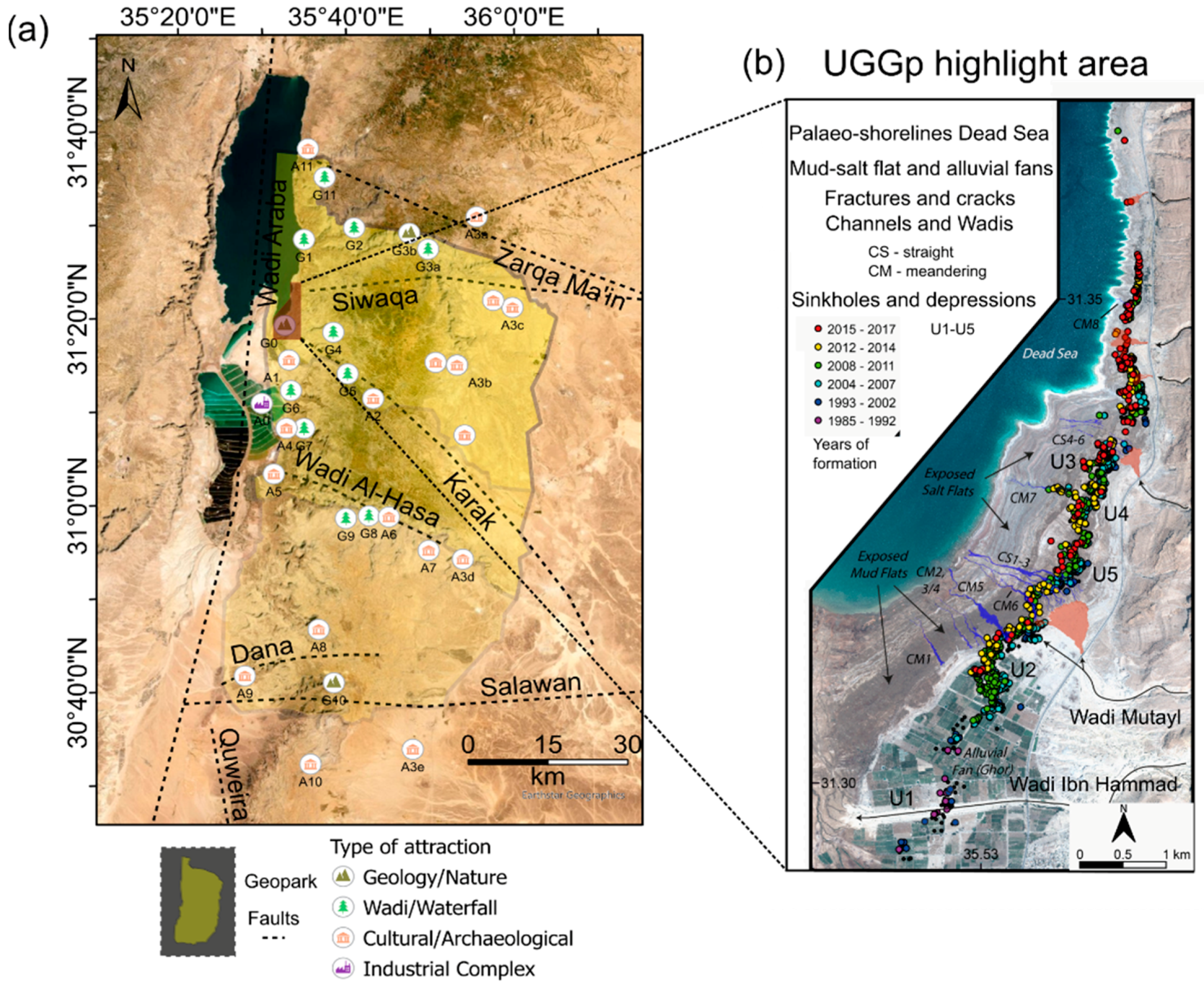
1.2.1. Previous Research and Specific Geohazards at the UGGp Highlight Area

A highlight area of the proposed UGGp lies close to the town of Ghor Al-Haditha, in the Al-Karak municipality at the SE border of the Dead Sea, located on a fertile alluvial platform (Figure 1). Panel (a) shows the most important wadi systems contributing to the hydrographic background of the geopark highlight area. Over the past decade, on average, 45 sinkholes formed per year, leading to extensive ground subsidence [26] NE of the town (b–e). Over the past 30 years, most academic research governmental actions have focused on this dynamically developing area. Starting in the early 1990s, the Ministry of Energy and Mineral Resources of Jordan (MEMR) has carried out numerous geologic and geophysical surveys at the alluvial flats (Ghors), at the border of the former stable shoreline of the Dead Sea (cf. Figure 1 in [32]), to understand causes and consequences of the dramatic morphological changes [33,34]. In addition, international research programs in the years since 2000 to the early 2010s explored for a presumed massive salt layer beneath the affected area using geophysical techniques [35,36,37,38,39,40] and delineation of sinkholes according to geological features in a rift system such as en-echelon structures [41]. The reader is referred to Polom et al. 2018 [32] for a comprehensive summary of the geophysical and hydrogeological surveys and their locations until 2010. The findings of that time relate sinkhole occurrence to the dissolution of a near-surface Holocene salt layer with large cavities postulated to exist around the entire Dead Sea and partly confirmed for the western side [22,42].
However, in the past decade, the German DESERVE project has focused on understanding the natural hazards at the Dead Sea [28]. Using a combined approach of geophysical, hydrogeological, remote sensing, and numerical simulation, a more detailed and more comprehensive understanding of the formation mechanisms of subsidence and sinkholes has been achieved. A map of all conducted measurements is shown in Figure 2a. That work included, but was not limited to, the interpretation of geomorphological structures such as depressions of different scales (uvalas and sinkholes), faults, and stream channel/gully systems (Figure 2b–d) [24]. Specifically, at GAH, a new hypothesis has been derived: ground deformation is primarily controlled by leaching fine marine sediments in complex-shaped brackish water karst conduits [29,32], also called subrosion in the scientific literature [32,43,44,45]. No massive (>15 m thick) salt (halite) body has been identified here by shear wave reflection seismics [32]. Geomechanical modeling studies confirmed that a sinkhole collapse and widespread sagging happens in both mud and alluvial material, producing characteristic morphological features that have been observed in the field [46,47]. A 2D conceptual model (Figure 3a) for large- and small-scale sinkhole formation in karst has been derived [47]. Follow-up studies have confirmed and extended this model into 3D, adding the connection between the karst conduits system and the development of stream channels and canyons [24]. Most recent studies that involve geophysical techniques, remote sensing, and density-driven simulations link the morphological development of stream channels and springs at the canyon site CM5 (cf. Figure 1b and Figure 2b–d) to a quickly changing underlying (karst) conduit system in the superficial aquifer [26]. In Figure 3b,c, the highlight area’s geologic, geomorphologic, and hydrogeologic background is shown. It consists of a dynamic karst area where the interface between fresh and saline water is locally different depending on water flow rates and dynamically evolving karst conduits that transport brackish water. Deeper in the subsurface, mixing zones may even extend further inland according to numerical models [26]. The exact extension of the conduit system both vertically and horizontally is still not known. It will be investigated within anticipated research projects to provide the scientific basis for safety monitoring. The proposed methods and anticipated survey areas of the scientific project MORFES are indicated in Figure 2 and discussed further in Section 1.3.2.
Generally, these new findings for GAH have helped the local authorities better define areas threatened by geohazards related to the local hydrogeological conditions and associated with spatiotemporal sinkhole development (cf. Section 1.3), and wadi inflow regimes. Areas most susceptible to collapse and sagging have been identified and show continuous sinkhole development. These areas are not considered suitable for any geotouristic activity and are subject to further monitoring and investigation together with adjacent areas. The planning for walkways and other geotouristic activity outlined in Section 3.1.1 is based on these findings and maps.

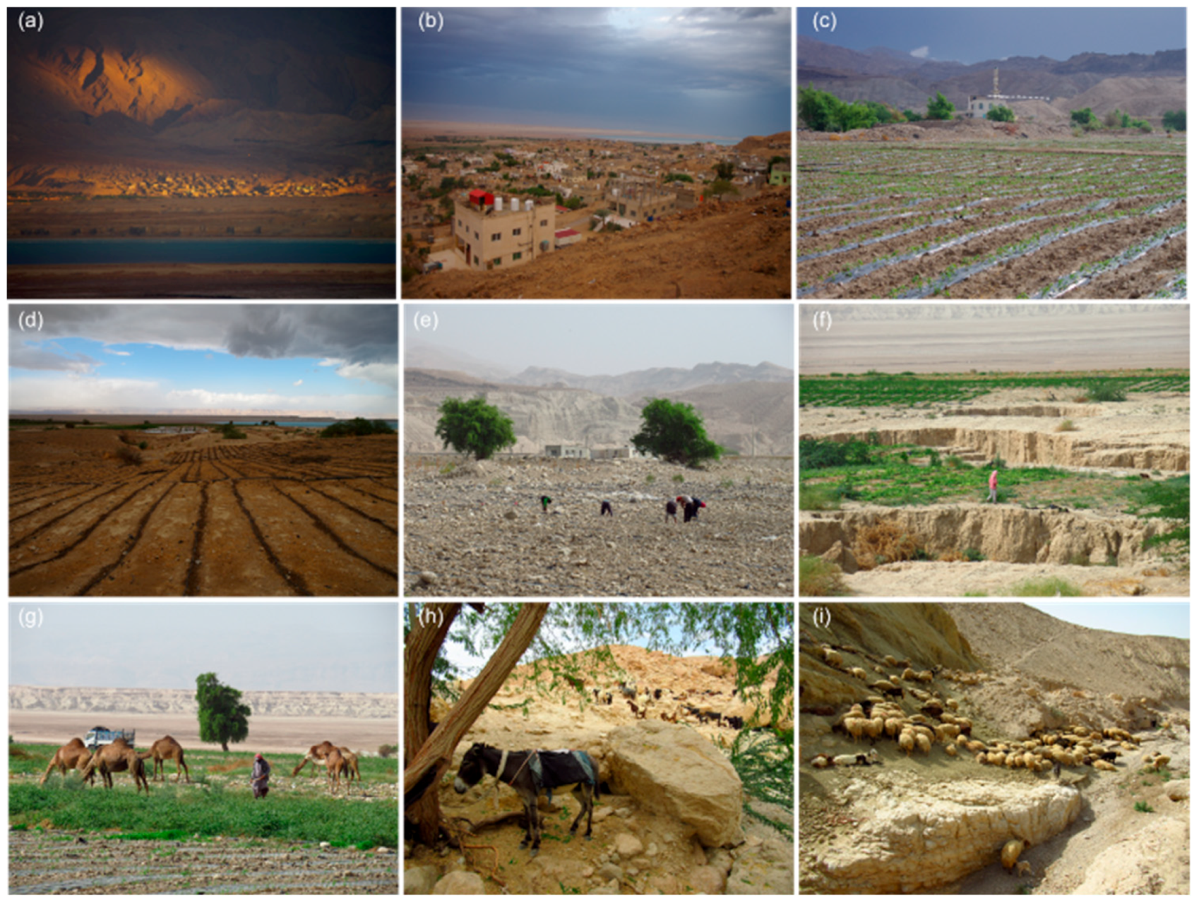
1.2.2. Challenges for the Local Inhabitants

Ghor Al-Haditha (GAH) town on the eastern side of the lake in Jordan has a population of about 2000 people and has grown by approximately 50% since 2000 [49]. The sinkhole and subsidence area is located northwest of the town and occupies a substantial portion of the fertile alluvial terrain. Regardless of the distance to the town center, the drastic morphological changes impact the community directly and indirectly. The town is an example of a community at the border between agricultural and urban life (Figure 4). Traditionally, inhabitants of the town have lived on self-sustained farming in the fertile plains, and Bedouins with long-term housing live in the area around Wadi Ibn Hamad. In general, the Ghor region is regarded as Jordan’s food basket. However, farming has become increasingly challenging due to droughts, high temperatures, sudden floods, the deepening of the groundwater level, the disappearance/sudden appearance of springs, and the emergence of dangerous sinkholes and subsidence.
Water scarcity is another significant challenge for Jordan’s agricultural sector. Jordan falls far short of even the water-scarce country threshold of 1000 cubic meters per person per year, with a per capita share of less than 140 cubic meters per person per year [50]. On the demand side, factors such as population growth, agricultural development, industrial growth, and increased tourism place increasing pressure on these scarce water resources [51,52]. The current annual freshwater consumption in the country is estimated to be 1057 MCM. On the other hand, renewable freshwater resources are projected to provide less than 896 MCM per year [53]. This mismatch between demand and supply requires careful water allocation planning among competing sectors.
More than half of the country’s water is currently used for agriculture [53]. This bias in water resource allocation is heavily influenced by the geographical location of the resources and their distance from other demand locations. Although irrigation water is critical for food production and security, there is a tendency to transfer water resources away from agricultural usage and towards sectors with higher economic returns per cubic meter, such as the industrial, municipal, or tourism sectors. To compensate for the shortage in freshwater resource allocation, renewable groundwater extraction has been pushed to 335 MCM/year. This rate exceeds the sustainable yield of the renewable groundwater in Jordan, which amounts to 275 MCM/year. In addition, non-renewable groundwater resources are being overexploited by a rate reaching 300 MCM/year [53]. Overexploitation of groundwater resources has resulted in considerable quality declines in several areas. Furthermore, contamination of the near-surface aquifer due to the misuse of pesticides and fertilizers was documented in numerous places [54].
In the GAH area, these conditions resulted in a 0.75 m per year fall in groundwater level in some of the region’s central groundwater wells, near the Al-Mazra’a pumping station [55]. Accelerated groundwater level decline is confirmed by local farmers and recent hydrogeologic simulations [26]. The main water for the area of Ghor Al-Haditha comes from groundwater wells and the Ain Maghara spring originating from the Ajlun carbonates outcrops east of the focus area (cf. Figure 5). The spring water is transferred via canals to the farming areas and partly used for irrigation ponds; drinking water supply for GAH is usually by delivery and storage in tanks on the rooves of the buildings.
The agriculture sector in the GAH region is suffering greatly due to the direct effects of sinkhole formation, which have ruined fields, residences, streets, electricity poles, and water tubes mostly between 2000 and 2015. Despite the high risk of sinkhole formation, farmers continue to use some farms within the high-risk zone simply by filling existing holes with gravel. This is primarily due to a lack of alternative options or sources of income. Jordanian officials are constantly evaluating alternatives to help residents in that region, and construction of dams in Wadi Ibn Hamad and near Al-Karak that may reduce the threat of flash floods are currently in progress [56,57].
In addition to the agricultural sector, the sinkholes have impacted various infrastructure and economic sectors in GHA. For example, the industrial factory of Dead Sea mud (Al-Numeira) has been affected by sinkhole development since 2004, and it closed in 2008 [58]. The area is now completely destroyed. The Arab Potash Company has also suffered major economic losses as a result of the area’s sinkholes and subsidence [59]. Bridges and highways have been damaged and restored as a result of the erosional phenomena of flash floods in the whole Dead Sea coastal area (Figure 6, cf. e.g., [60,61]). The main highway, which serves as the primary commercial link between Amman and the southern towns, is under threat from this geologic phenomenon (cf. evolution map in Figure 7b). Under these conditions, the town and its surroundings face challenges in sustaining the lives of the growing population and will need to undergo a significant transition to a more sustainable way of life. The local knowledge and community interest in providing alternative sources of revenue and education, particularly for young residents, may serve as a foundation for establishing a UNESCO Global Geopark.

1.2.3. Aspiring Geopark

Overview

Figure 7a shows a detailed overview of the proposed UGGp location and its extent in the context of regional geography. Panel (a) shows a topographic map with the proposed area of the geopark and the most important geological/ecological and archaeological/human features. A list of these features is given in the companion paper [20]. The proposed location of the UGGp places it almost entirely in the Al-Karak and At-Tafilah governorates. The territory would be bounded to the N by the Wadi Mujib Reserve, to the E by the plateau of the Moab mountains (Highway no. 15), to the W by a boundary 5 km from the center of the Dead Sea, the shoreline of the Lisan Peninsula and Highway no. 65, and to the S by the administrative borders between Tafilah, Maan, and Aqaba governorates.

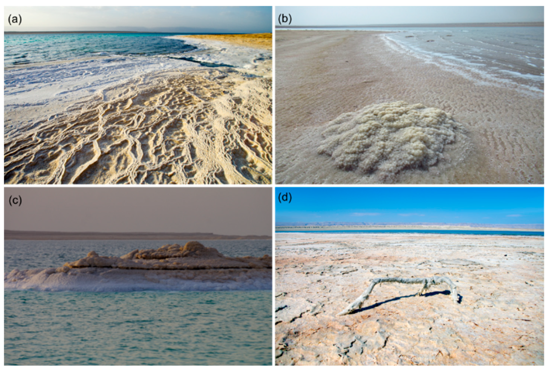
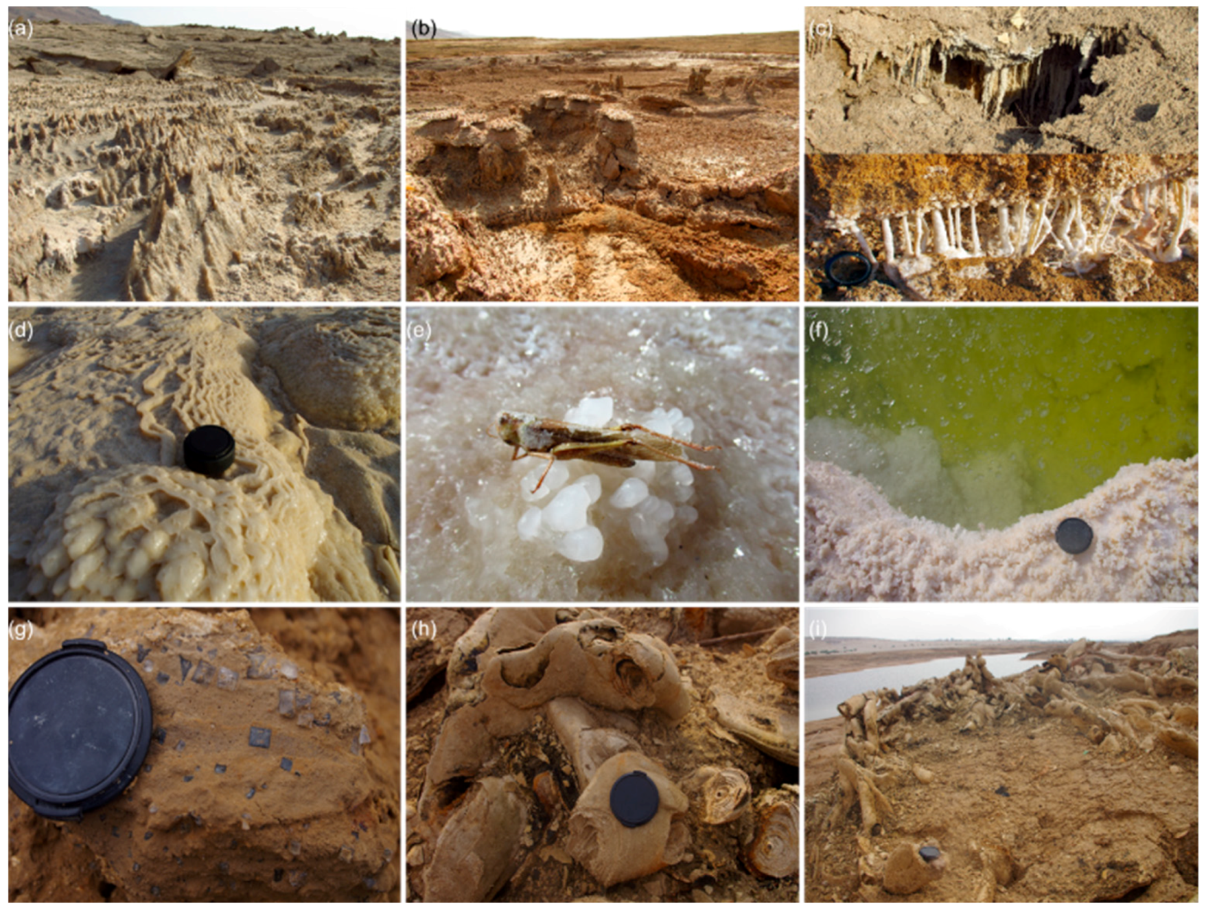
Geological Features of International Significance in the Highlight Area—Ghor Al-Haditha Sinkhole and Subsidence Site

Ground Views of Sinkholes and Depressions.
The map in Figure 7b shows in detail the features found around and in the main focus area of the proposed geopark. The Eastern Rim Highlands provide the hydrographic background of most of the features in the territory. A high mountain and deep wadi valley system, together with shallow (alluvium) and deep (sandstone, limestone) aquifers (cf. geological map in partner paper I), provide the water resources that accumulate towards the SE shore of the Dead Sea. Besides wadi and groundwater flow and flash floods, the formation of subsidence and sinkhole features relies on the abundance of evaporite minerals in the subsurface and their dissolution and mechanical removal. This subrosion of the underground by strong water flows of undersaturated water creates hollows and voids, resulting in the removal of soft material with subsequent sagging, crack formation, and collapse of the overburden. A large variety of these features can be observed (Figure 8) in the highlight area of the UGGp.
Stream channels, springs, and vegetation.
Groundwater and surface water from wadis with catchments in the Eastern Rim Highlands bring fresh water into the fertile plains. There are several aquifers of tertiary age and superficial character (e.g., alluvial sediments of the Lisan marl) and outcropping of early cretaceous (Kurnub sandstone) and late-cretaceous/early Tertiary age (Ajlun-Belqa carbonates, see geologic map in partner paper I), which may also release water under the Dead Sea through submarine springs, as evidenced on the Western side of the lake [62,63]. New stream channels are forming inside the dynamic salt karst system (Figure 9a–c), and springs often are related to sinkhole formation (Figure 9d–e) and canyon development (Figure 9f), loaded by sediments and dissolved minerals (Figure 9g). New, dynamic springs with vegetation appear in the exposed mudflat area of the former Dead Sea bed (Figure 9e–h), mainly between the alluvium and mud limits, guided by paleochannels. However, there are plenty of springs, partly sulphurous, in the mountains (Figure 9i), of which the local inhabitants conserve the main knowledge for e.g. feeding sheep and goats. Lush vegetation grows around these springs, adapted to a certain salt content of the water as in some of the areas, conserving special eco-systems with abundant birds and insects.
Evaporite minerals and salt formations.
Figure 10 and Figure 11 show the variety of evaporite formations, structures, and minerals both on the former lakebed and in shallow waters of the Dead Sea. Many minerals have been discovered, such as halite, calcite, aragonite, and gypsum, mostly in aggregations with clay minerals [64], as surface cover, and as individual layers of up to 2 m thickness visible in sinkhole or canyon walls [29].

1.3. Ongoing and Future Research in the Territory of the Proposed Geopark

1.3.1. Ongoing Research on Environmental Changes

After the intensive research performed between 1990 and 2019, a period of quiescence in hazard observation and monitoring has followed. Additionally, the global health situation made it difficult for international researchers to start new projects. However, national comprehensive research programs are ongoing. The Royal Society for the Conservation of Nature (RSCN) performs periodic ecological surveys within the nature reserves covered by the suggested geopark area related to biodiversity in particular [65]. It carries out different research programs in protected areas to guide its management and monitor the environmental changes. The Jordan Valley Authority (JVA), which was established in 1977 as an independent authority and became part of the Ministry of Water and Irrigation (MWI) in 1988, is a governmental institution concerned with the management and development of water resources and lands in the Jordan Valley including the Southern Ghor region. It aims to protect the valley and contribute to observing its environment, i.e., precipitation changes and droughts. The JVA performs further development and research programs in the region [66]; however, describing the complex projects in the territory is beyond the scope of this paper.

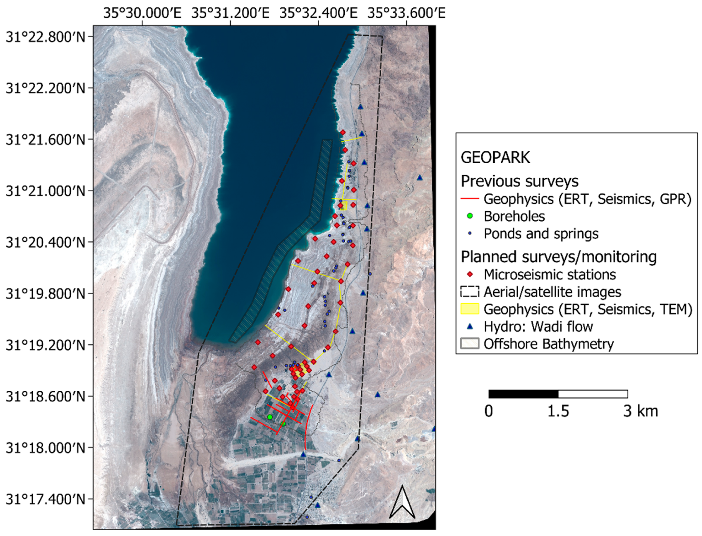
1.3.2. Planned International Research—The MORFES Project

Helmholtz institutions from Germany and universities from the US and Ireland have expressed their interest through a support letter in developing long-term research projects in the proposed geopark territory. These will address terrestrial and submarine groundwater discharge estimation, and earthquake, flash flood, and ground deformation hazard monitoring. One of these projects that plays a central role is MORFES. Carried out at the German Research Foundation (DFG), it will address the morphology of fluid-escape structures, a crucial part of the definition of safe geotouristic sites. Fluid escape structures form at the interface between on- and offshore zones and provide gas or water outflow connected to the deformation of the underground. Large mass movements and collapse processes and stream channel formation are related to these fluid escape structures. Based on the aforementioned previous research and the identified challenges for the local population, this new scientific project will investigate surface and subsurface physicochemical processes that include evaporite dissolution and sediment erosion in a combined field-data acquisition and numerical modeling approach.

Tools and Technical Background

To assess shallow and local hazards such as ground subsidence formation and collapse, several geodetic and geophysical techniques are commonly applied to karst aquifer regions such as the Dead Sea: (1) InSAR or laser scanning [25,67,68], (2) seismic activity as well as gravity monitoring [45,69,70], and (3) electric and electromagnetic methods [71,72,73]. The most crucial aspect for monitoring the ground-scale sinkhole and subsidence hazard is the relationship between subsurface water flow and rock failure processes. Cost-effective near-surface hydrogeophysical methods are valuable tools for investigating these processes [74,75,76]. However, previous work has shown that the interpretation of the data can be improved with the help of (hydro)mechanical numerical modeling [77,78,79,80,81,82]. For example, for the highlight area around GAH, the existence or non-existence of a salt layer is not the limiting factor for the appearance of subsidence; instead, it is the mechanical stability of the material combinations and the failure process itself [46,47]. More researchers at the Dead Sea have used the proposed methods to investigate sinkhole precursory information. So-called nanoseismic monitoring using short-period sensors in boreholes has been applied successfully by [70] to show collapse signals in a broad subsidence area of the western shore. Impacts of individual rocks during unconsolidated material collapse could be identified in a similar study analyzing the frequency content of such signals [83]. Radar interferogram analysis showed precursory small-scale (mm−cm) subsidence and revealed the evolutionary history of individual sinkholes [25]. Self-potential, together with electric resistivity interpretation, documented the complexity of karst conduit flow and possible new collapse zones at Ghor Al-Haditha [26]. These positive examples serve as the basis for the following suggested comprehensive geoscientific monitoring for the highlight area of the proposed UGGp.

New Approach

In a combined approach, the advantages of each method can be used to address the different goals related to the establishment of the proposed geotouristic sites in a natural hazard area. Several geoscientific data acquisition methods are planned to characterize the flow system and its extension, material composition, and surface/subsurface deformation (see detailed Figure 12). These include near-surface geophysical methods, hydrogeological measurements, satellite image analysis, and geotechnical sediment/chemical water sample characterization. In addition, a hybrid of machine learning and physical models will be applied in a structured transfer learning approach to enable underwater prediction of geological structures. The analysis of this data and complementary datasets from the western shore will form the basis of a cutting-edge numerical model to be adapted, validated, and for comparison Based on coupled computational fluid dynamics, discrete element simulations of the spring/canyon system, new insights into the development of porous and conduit flow, material transport, and chemical reactions in a multiphase system are sought. As the primary outcome, these models will help understand the processes and resulting morphological features that develop specifically at the UGGp highlight area. The results and scenario simulations will be transferred into a regional conceptual model suitable for hazard assessment. The onshore focus area will overlap with planned geotouristic walkways covering the most active area (Figure 2a and Figure 12), see also Section 3.1.1.
In addition to the expected direct scientific results, the role of water overexploitation in the entire context of environmental aspects of the Dead Sea area will be discussed through educational tools. This international and interdisciplinary project will integrate student projects and knowledge transfer between the different entities of local inhabitants, stakeholders, and researchers through workshops, school projects, and summer/winter schools in the region. The initial duration of the project is envisaged to be four years, starting in 2023.

Goals

The following societal and scientific goals form the framework for the projects at the proposed Dead Sea geopark:
Societal Goals: (1) Safety—the monitoring system should help reduce the threat for the population, tourists, farms, and infrastructure, help spatial planning for walkways and information centers, raise the people’s awareness and preparedness, and provide a hazard assessment for the local authorities. (2) Education—workshops, student schools, and information meetings will enable the transfer of knowledge to the local authorities about the local disaster, its management, and risk reduction. (3) Economy—it can help to identify saltwater intrusions and provide information on changing agricultural conditions to enable quick adaptation. (4) Protection—as a safe ecotourism site, the system may also help to protect the landscape and nature by identifying risk and threats a priori, i.e., contamination.
Scientific Goals: (1) Identification of potential triggers of sinkhole, subsidence and landslide hazards, such as earthquakes, natural or man-made changes in the groundwater flow, hydraulic transients in fault zones, flash floods related to strong meteorological events, and combinations of these. (2) Determination of ground stability parameters to properly define risky and safe zones in the affected area. (3) “Early-warning” and information about the continuation of the process, relevant for the long-term perspective and other places in the world.
Exemplarily for GAH as a representative site of the proposed geopark, we discuss the integration of geoscientific monitoring under the above consideration of the aims and goals of the UGGp, the scientific basis of the current hazards and existing data. We provide an overview of the challenges such an installation may face, focusing on safety concepts, data reliability, costs, and communication.

2. Material and Methods

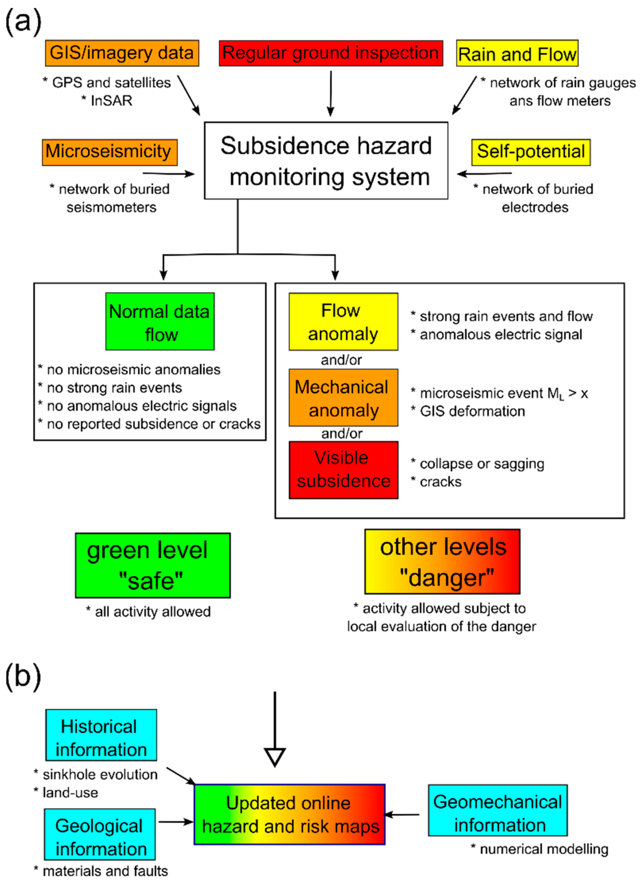
2.1. Technical Methods for Hazard Monitoring and Safety Provision

For active hazard areas such as the Ghor Al-Haditha sinkhole/subrosion site, we suggest an installation of a combined GPS, self-potential (SP), water level/flow, and seismic measurement (SM) system around relevant areas identified as susceptible to subsurface water flow and material failure (Figure 12). This susceptibility will be defined continuously by InSAR and semiautomated satellite image (SI) analysis. Furthermore, a geodetic monitoring system will be included by installing time-lapse observation cameras and fixed ground control points to offer long-term photogrammetric study. Available geodetic data will be used to identify zones that have shown strong ground movement in recent years; this will be confirmed by the experience of local inhabitants and experts.
On the ground, the system will be enhanced by regularly performed ERT (electric resistivity tomography) to identify zones of distribution of fresh and saltwater at shallow depth underground, representing the dissolution horizons. Combining these preparations will define several focus areas close to agricultural areas, walkways, and infrastructure that are considered necessary for the local community and tourists. In these areas, the monitoring system will be installed and consists of the following equipment:
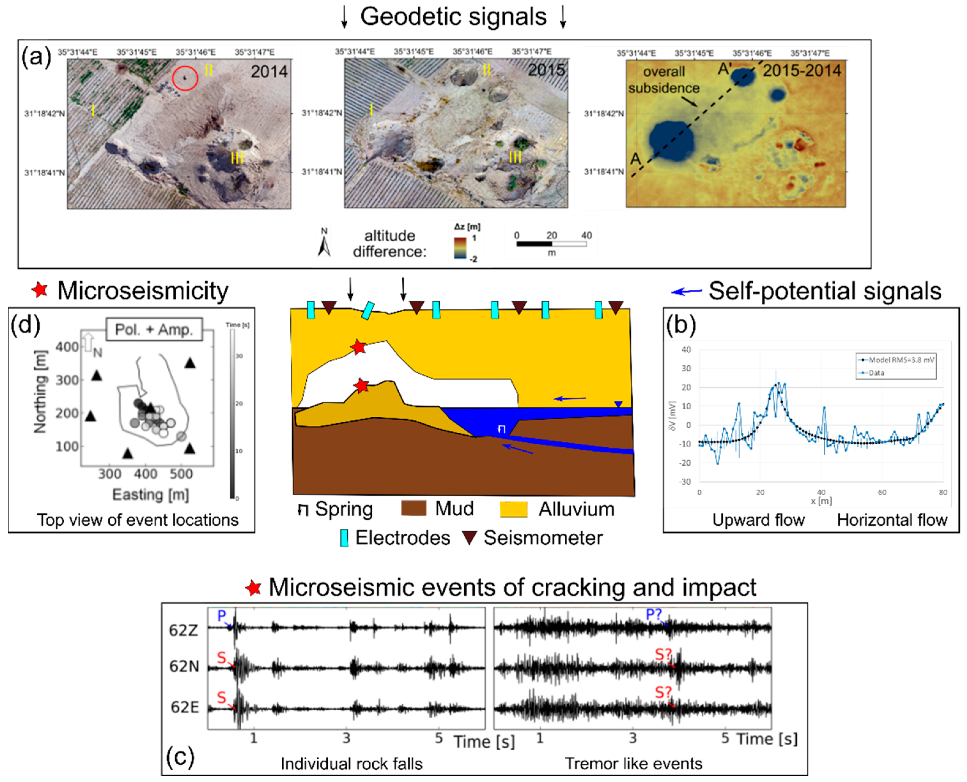
  • Buried electrodes (around 100 devices) and data logger to record electric signals in the monitored area. With this, water-flow patterns, both horizontal and vertical movement, can be resolved by the electric potential arising from a so-called electric double layer between the aquifer matrix and fluid. This self-potential method has been successfully used in groundwater flow determination in karstic and sand aquifer areas and sinkhole identification [26,84,85], including the location discussed here.
  • Buried seismometers (around 50 devices) and data logger to record seismic waves of cracks underground. Seismic methods are widely used to investigate structural features and localize cracks and collapse processes underground, and microearthquakes (microseismicity) can occur directly before a hazardous collapse [43,83,86].
  • Fixed GPS stations (5) to record horizontal and vertical ground movement. Differential GPS correction will be performed by a base station nearby.
  • Installation of time-lapse cameras (5) in buildings or on telephone poles to record images that can be processed directly via photogrammetric software to see immediate changes of the surface, e.g., cracks and subsidence.
  • The data will be transferred via wireless satellite links standard for seismic stations directly to the partner institutions and analyzed by experts at the research institutions and national agencies.
These geophysical monitoring methods offer completely passive recordings with no environmental impact and will be powered by solar energy with regular maintenance and protection by the local community. The necessary devices can be provided through long-term renting (GIPP pool of the German Geosciences Centre Potsdam) or direct funding for such equipment via the budget of the proposed MORFES project outlined above. Cooperating partners will also provide part of the equipment. The MEMR has worked for several decades successfully with partner institutions in Germany on hazard investigation and continuous data transfer techniques with a focus on earthquakes and sinkholes. For example, permanent and temporary seismic stations are integrated into the GEOFON live stream network of the German Research Centre for Geosciences (GFZ) [87]. Figure 13 presents an assembly of typical signals expected for microseismic, self-potential, and geodetic monitoring during sinkhole formation.

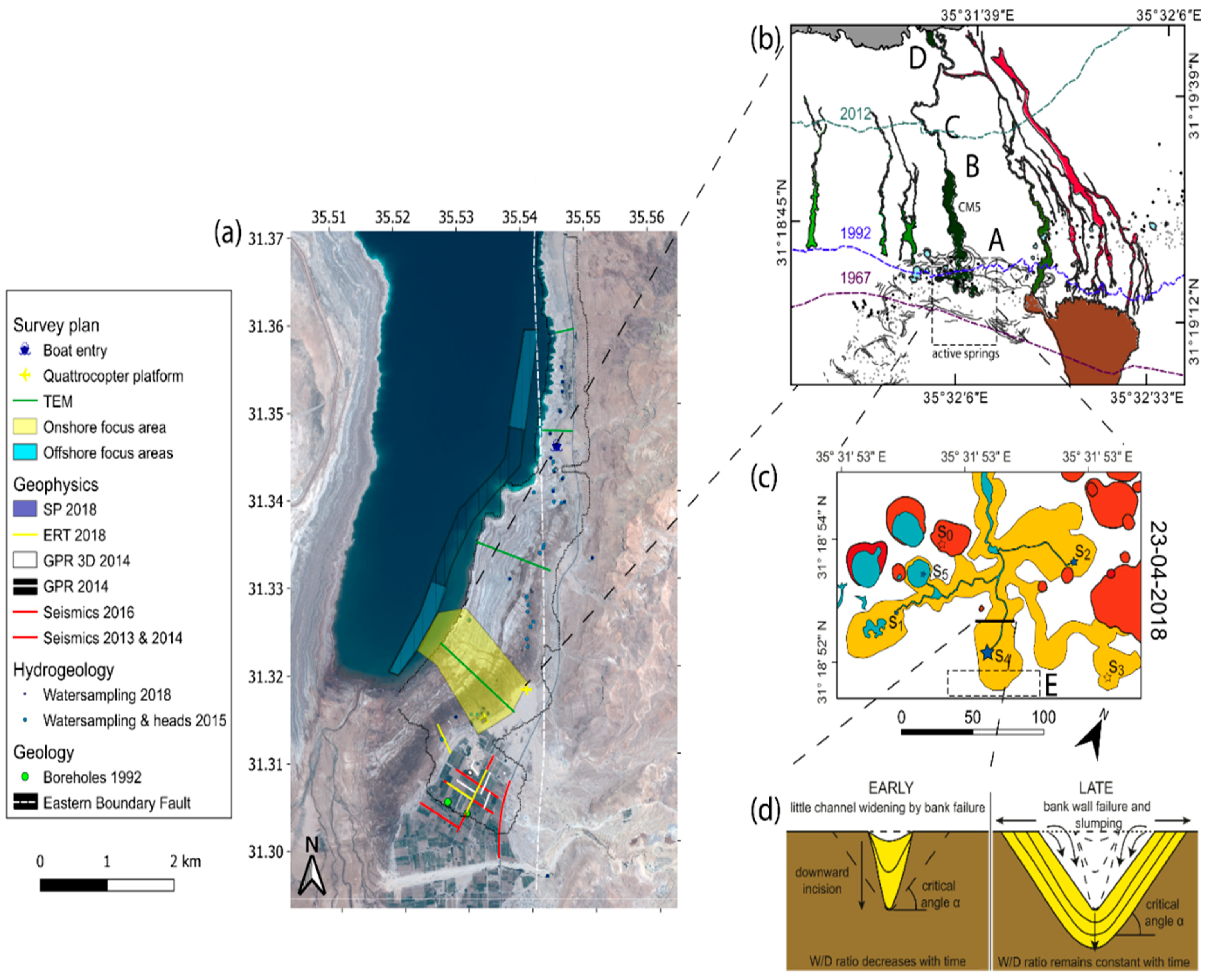
2.2. Datasets and Methods for Field Campaigns and Geotouristic Trail Selection

Remote sensing: Available remote sensing datasets include satellite/aerial images from 2002, HR orthophotos, and digital surface models for 2014–2016 [24]. New drone surveys with wide-angle lens cameras are planned to acquire data on morphological changes. If permissions for drone flights are not acquired due to security reasons, alternatives with simple low-altitude balloon recordings will be used, as we have proved these to be usable in this region. Furthermore, high-resolution (≤0.5 m/px) satellite images (e.g., Pleiades-Neo, Worldview) will be purchased.
Ground sensing: As an additional feature, a small endoscopic camera system, will be inserted into the first 10 m of a karst conduit to explore its extension and void spaces and provide a detailed 3D model. This will provide numerical modeling (see below) with improved ground conditions and internal conduit shapes.
Rainfall and flow: Hydrologic data (rainfall) will be provided by cooperating partners upon request from the MWI. Flow velocities will be recorded at active channel heads by installing temporary (wet-season) discharge measurements at the spring locations. A mounted camera/radar system with continuous persistent data storage on FTP servers will record level and velocity in the most stable area a few tens of meters downstream of the springs by a mounted camera/radar system with persistent data storage on FTP servers. The system will monitor discharge and offer continuous image collection for photogrammetric analysis of channel widening and slump failure.
Electric and electromagnetic methods: Repeated ERT measurements are planned, as well as coverage of the focus area around canyon CM5 (cf. Figure 2c and Figure 12) and the neighboring regions by TEM to identify the overall distribution of the saline−freshwater boundary and changes in this saline environment as well as the extension of the karst system. The envisaged geophysical observation system (see below and Section 3.1.2) will enable a fast reaction upon changed conditions by the local stakeholders.
Water and sediment sampling: For chemical analysis, on- and offshore water sample collection is envisaged. The new hydrological selection of springs will focus on establishing hydrochemical end-members and answer the question of the origin and mixing paths of the groundwater to determine significant pathway changes within recent years, a crucial factor in hazard estimation. At the channel banks and sides, sediment samples of alluvium and mud, and rock and salt samples, will be collected for age determination and laboratory tests. A set of the sediment blocks will be transported to GEOMAR for geotechnical testing, including triaxial testing of saturated samples and detailed small-scale investigation of pressurized fluid flow through salt-rich samples. A simulation of shallow marine environments with the same devices can be done to determine changes to these processes under different conditions. Unaltered samples will finally be stored at the core repository at GEOMAR.
Numerical Modeling: A 3D hydromechanical model of the CM5 canyon/spring system (Figure 2c) will be established and includes porous and conduit/channel flow, physicochemical erosive processes, and macroscale deformation of the ground. It will be calibrated using the hydro-geo-data acquired above. The coupling of different techniques (computational fluid dynamics and discrete elements) has become increasingly used and most promising for hydromechanical collapse processes [89,90]. The model results will be upscaled to multichannel systems, and a conceptual model should be established for the region. Together with the geo-data analysis, this model will serve as the basis for scenario simulation, hazard assessment, and a potential sustainable geotouristic exploration of the area.
Underwater investigation: The submarine investigation will be conducted at the immediate conduit outlets in the shallow Dead Sea delta area for the first time. Several locations have been identified as prone to submarine groundwater discharge (SGD) in previous studies both on the western side of the lake [62,63] as well as in the measurement area (see aerial photos in partner paper I and [47]). The gain will be a better understanding of the system before- and after lake regression and the relation of SGD to the future collapse of the exposed ground. A small vessel will be chartered and multibeam, sub-bottom and side-scan sonar, and profiling with an Ocean Floor Observation System (OFOS), is planned for focus areas where the active stream and conduit flow has been observed during recent years. The OFOS consists of a 1.5 × 1.5 m frame with a mounted conductivity−temperature-depth (CTD) system and a camera for photogrammetric mapping. If permissions for offshore data acquisition are not received due to security reasons; the focus will lie on shallow water bathymetric analysis of multispectral satellite images [91].
Automated structure recognition: To better define active subsidence zones, a semi-automated system of structural feature detection using high-resolution satellite images is currently being developed at the Helmholtz Centre for Ocean Research Kiel, Germany. The aim is to use machine-learning techniques trained by available large sinkhole, stream channel, and crack datasets of the proposed geopark highlight area to quickly identify ground deformation. This system will need human supervisors and a constant feed of geophysical and geodetic data. An extension of this system to the offshore areas is envisaged, by applying a transfer learning scheme. Here, annotated in-air data shall be augmented with a physically-based water layer, tailored to resemble the Dead Sea water to train neural networks. This hybrid approach jointly employs physical models and neural networks in a structured learning approach to yield faster and more robust results [92]
Fieldwork and Geodiversity: Geologic fieldwork, i.e., recognition and mapping of structural features (faults, cracks, depressions) and material distributions, together with the above-described methods to delineate depressions, will serve to create a digital inventory for depressions, dolines, and other karstic features similar to [93]. This continuously updated geosite inventory will be relevant for both hazard assessment and geotouristic exploration, i.e., walkway planning.
Hike and bike trail selection: Field recognition, continuous evaluation of hiking trail difficulty levels, safety conditions, weather conditions, and facilities are common methods to select hiking trails in natural hazard areas. The assessment of environmental risks will follow typical evaluation procedures, so-called risk matrices or tables [94], and a continuous adaptation to actual conditions is necessary. See below for further details.

3. Results and Discussion

3.1. Safety Concepts in Hazardous Areas

Safety concepts differ for the various types of hazards identified in the region, such as landslides, slow or fast subsidence, flash floods, and storms. For other touristic sites near the UGGp, commonly restricted access, region-wide and longer-term closure have been the solutions for dangerous periods of the year. Even several years-long closures have been reported due to safety reasons. However, in terms of efficiency, a monitoring setup and expert training and surveillance with a proper adaptation to site conditions would probably be more useful. Initially, before setting up a sophisticated system, simple flow and GIS monitoring from dedicated bodies of the authorities is an option to allow a quick reaction in constructing flood barriers or reinforcements, which are commonly done at the Dead Sea area. To complement “classical” engineering and construction hazard preparedness, we propose a mitigation-related approach to reduce the vulnerability in the affected areas. We suggest a geoscientific approach to monitor areas susceptible to geohazards with appropriate (geo)technical systems. This approach is embedded into high-quality scientific research in the geologically unique environment of the Dead Sea and will enable the establishment of early-warning systems. As an example, the planned monitoring concept for the UGGp highlight area Ghor Al-Haditha sinkhole and subsidence site is outlined below. It goes together with the sensible planning of geotouristic infrastructure in the same place.

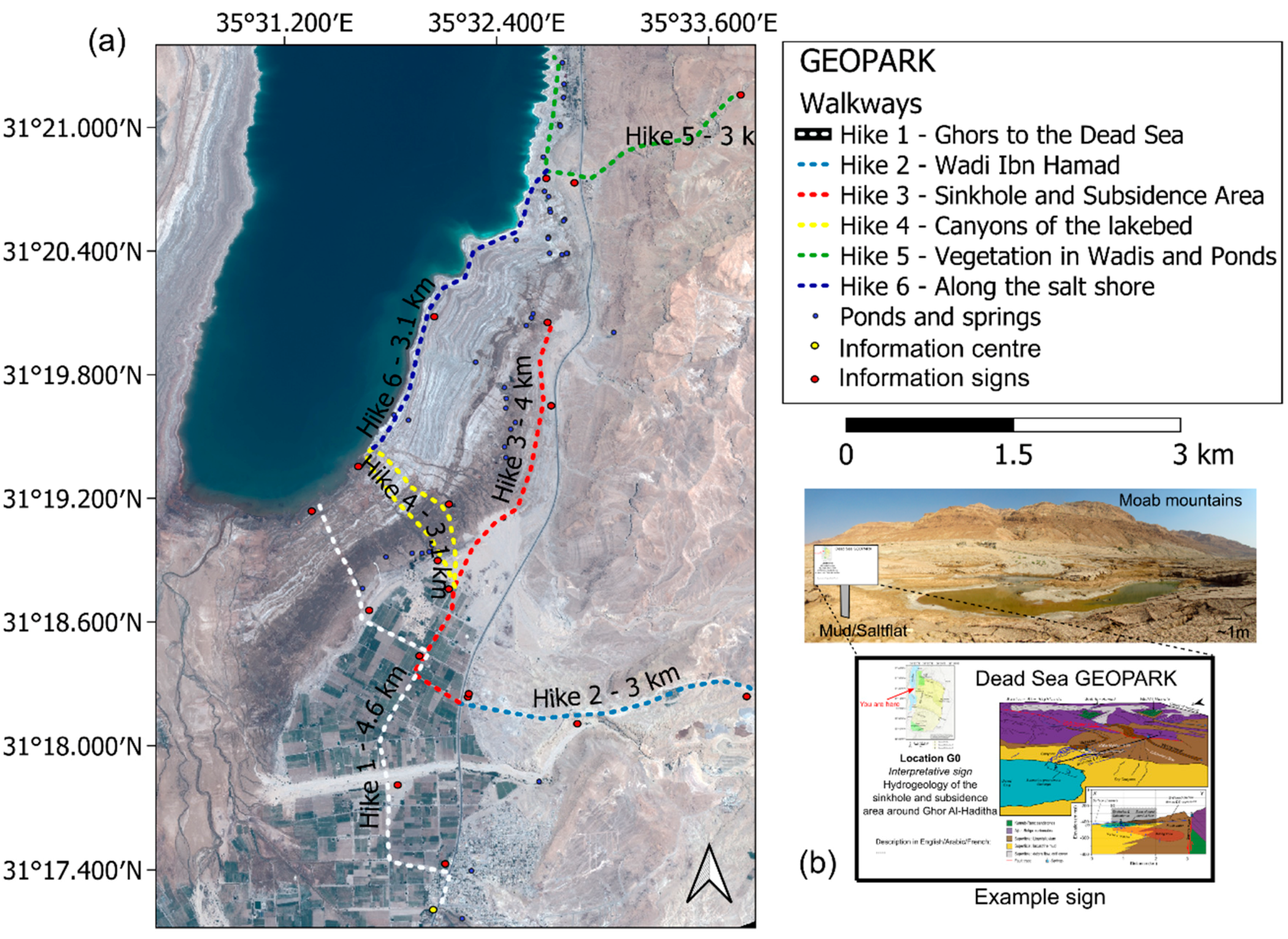
3.1.1. Trails and Infrastructure Planning at the Highlight Area

Different walkways and geo-urban hike trails that local guides should follow are shown in Figure 14. The planning of these walkways is based on the extensive research performed at the area of interest and on the experience of local NGOs. The hikes surround the most active areas, with a safe distance of at least 100 m from any sinkhole formed during the past five years. Elevated trails should be established for walkways in subsidence areas to reduce risk in moving terrain, e.g., suggested hikes 3 and 4 and partly 5 and 6. Especially for hike 4, which is likely the one with the highest sinkhole/subsidence and slumping activity around, special safety rules will apply following typical risk assessment tables/matrices for adventure tourism [94]. This means experienced local guides, a longer stability phase, and stable weather conditions are needed based on an assessment matrix. In this area, NGOs are already offering bike trips around the area of the sinkholes [95], and integration into the geopark concept is desired. Generally, a ground sign as in Figure 14b could be deployed at the guided walkways through the geopark; in this case, close to the sinkhole formation zone at Ghor Al-Haditha. The location of the information center, the main one of the geopark, needs to be thoroughly defined according to the most recent hazards and risk maps provided based on the monitoring and geophysical investigation and geomechanical considerations.

3.1.2. Hydrogeophysical Investigation and Monitoring at the Highlight Area

As outlined above (Section 2.1), combined geophysical and hydrogeological fieldwork and monitoring is planned for the geopark highlight field site, GAH, at the eastern Dead Sea on- and offshore locations (Figure 2 and Figure 12). The plan is to build upon existing datasets from recent years (Section 2.2) and apply new, complementary machine learning methods in areas prone to rapid hydrodynamic changes.
A continuous self-potential and microseismicity monitoring network will be set up in the region. The electric current monitoring focuses on the canyon head of CM5 (Figure 2c), complementary to the discharge measurements. Nearby wadis will be equipped with flowmeters, and seismic stations will be distributed around the most active zones. The installation of a hydrogeophysical monitoring system with a high potential for early warning will address critical aspects of hazards in this area (subsidence, water conduits, flash floods). A graphical representation of the monitoring system is given in Figure 15. Experts from scientific institutions will analyze the data continuously and provide a regularly updated hazard estimation and risk map, using integrated geodetic and geophysical data, geologic knowledge, and input from geomechanical modeling.
A typical ideal example triggering the signal flow of such a monitoring system is described shortly in the following, referring to examples of the anomaly types in Figure 13:
A0.
Continuous data flow without anomalies in electric or seismic data.
A1.
Record of anomalous flow and strong electric potential related to subsurface water flow (flash flood).
A2.
Record of microseismic events in the subsurface (cracking, first material failure).
A3.
Subsidence appears at the surface, which is recorded by the GPS (late-stage).
For (A0), an example for normal data flow is visible in the microseismic recording of Figure 13 between the identified events. It consists of relatively smooth N, E, Z components with no strong amplitude changes due to the arrival of P and S waves associated with cracking and collapse. For details on processing, identification, and localization of microseismic events, refer to [88,96]. In SP, a linear signal between two stations is considered normal, referring to continuous flow without changes, e.g., in an unconfined aquifer. However, SP signals are not unambiguous, influenced by topography, weather conditions, and chemical signals, and as for all potential field methods, depth determination of the anomalies is limited [72]. Current improvements suggest a variety of error reduction procedures, e.g., topographic corrections and quantitative estimations [73].
For (A1), the SP signal would show a sudden increase/decrease depending on flow direction (i.e., electric charge). Typical anomalies are dipole type for an increased sheet flow or bell type for up/downward flow, e.g., in a karstic conduit or fault. For more details on classical anomaly types that can be easily identified in SP readings and aerial contour plots, please refer to [73,97].
After (A1), a warning is issued to the local authorities and measures are taken to protect the population, subject to further development (A2), e.g., the evacuation of the fields, houses, and walkways may be needed until collapse or normal data flow, i.e., a linearization of the SP and smooth seismic components Examples of microseismic events (A2) that relate to cracking the ceiling in a cavity or impact of rock onto the ground or onto brine are given in [83,88]. After (A4), the highest risk level because of the onset of ground subsidence as estimated by local GPS measurements is reached.
The cases A1–A3 will be represented for simplification as yellow, orange, and red warning, as typical in volcanic risk estimation. The base, a green code (or A0), and green signs at the entries to the hazardous zones means a safe passage for locals and tourists and relates to continuous longer-term normal dataflow. An example of such a simple warning sign is shown in Figure 16.
Even by considering advanced interpretation techniques for SP and MS data, such a case as described above must be considered ideal, as obviously not all systems might show an anomaly simultaneously in a critical situation. Or, anomalies could be created by other sources, like electromagnetic disturbance or strong ground movement by agricultural equipment. The time between the recording of an anomaly and the actual collapse might be too short to react for the local authorities. Due to the common satellite revisit period of a minimum of 5 days [98] and the amount of data needed for processing [99], the InSAR method is also not suitable for on-site real-time observation but rather for helping to define general active areas. Finally, elastic rock parameters of the overburden above a dissolution zone are also crucial to the appearance of subsidence before the collapse. Therefore, risk maps will be constantly updated. However, all these issues will be addressed thoroughly by continuous learning and experience in data analysis, numerical modeling, and reading and interpretation of risk maps. Finally, the observation period (“dry-run”) should contain several dry−wet cycles, which means up to several years in such an arid climate, before a touristic exploration may start.

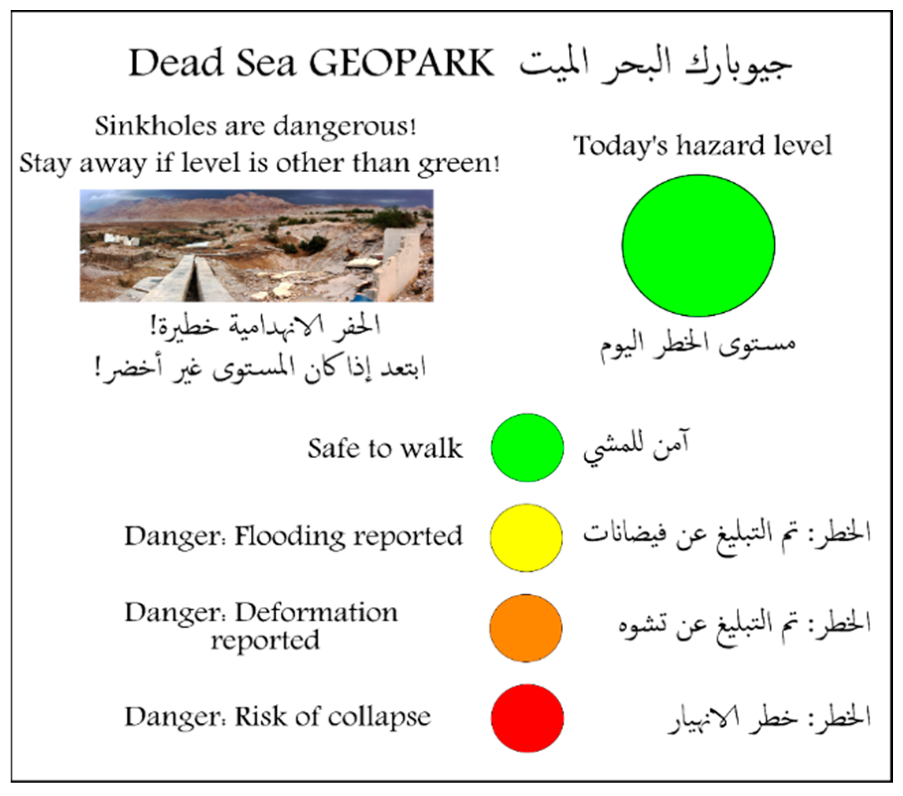
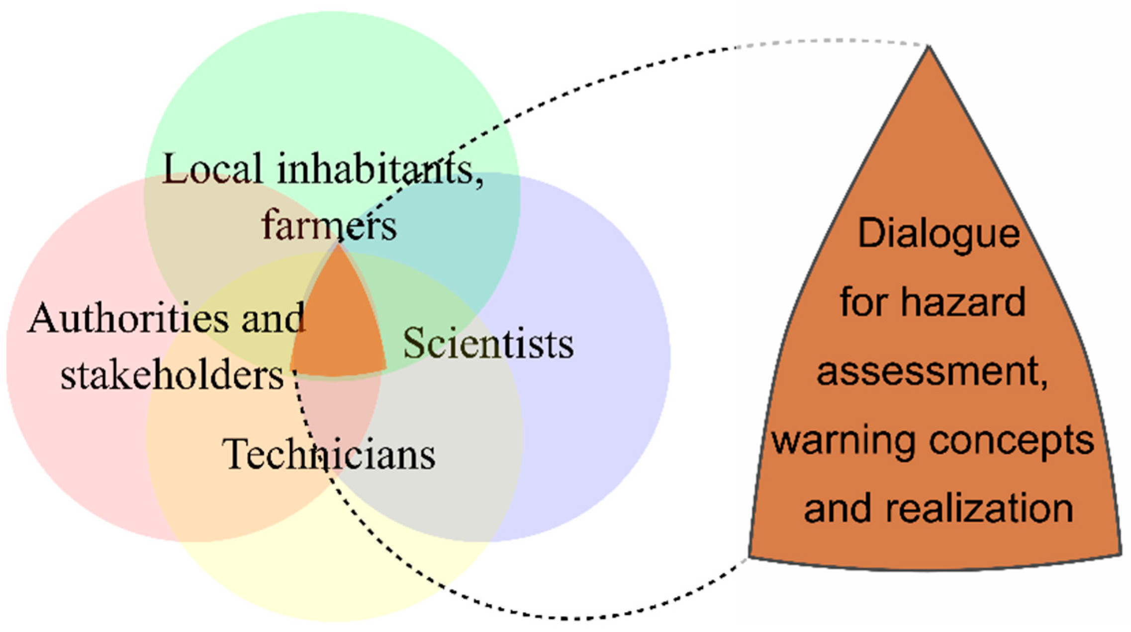
3.1.3. Communication of the Observations to the Local Stakeholders

To improve awareness and resilience of the affected communities regarding local hazards, the communication of scientific results to local stakeholders is the most crucial part, and often poor implementation leads to delays and even failure. The following information chain will be established through existing and further improving communication channels and long-term partnerships between the Helmholtz institutions, the governmental bodies (MEMR), and the local communities. A two-way dialogue between scientists, local authorities, inhabitants, and territorial technical experts is the most important aspect, leading to an overlap structure (Figure 17).
Five essential safety points have to be considered:
(1)
Local population (here: farmers, citizens, and workers in Ghor Al-Haditha) will be strongly involved in training, education, and long-term maintenance of the technical equipment. A direct communication link between the monitoring teams and the local partners will be constantly available and will serve to inform the community upon ad hoc changes.
(2)
Local authorities (the Geologic Survey of Jordan as part of the MEMR) will receive and divulgate notifications about expected dangerous subsidence or sinkhole/landslide formation and important changes of the hazard from the monitoring teams (local population, MEMR, GEOMAR, and other scientific institutions).
(3)
Regular and event-driven local workshops/information meetings will be held to communicate the stable and unstable zones and the flood risk in the region. Part of the information concerns the link between excessive water usage and dissolution of the salt-rich underground.
(4)
Upon recommendation by the MEMR and local technical experts, suggestions for recovering/rebuilding and moving agriculture and infrastructure will be provided. The areas will be updated where touristic activity can be safely performed sustainably and where new sites of potential geotourism can be added.
(5)
The information on infrastructure change will vice versa be transferred to the scientific monitoring teams to update the vulnerability of the areas, hence the risk maps. This links back to point safety point 1 in a two-way dialogue.

3.1.4. Expected Costs and Benefits

The establishment of such a detailed monitoring system is cost-intensive. A large number of short-period seismometers is the most expensive part. Flowmeters, GPS stations, and cameras also amount to higher costs. However, in combination with the self-potential method, the cheapest geophysical technique available for monitoring the near-surface and fluid flow [73], and the deployment of relatively inexpensive unpolarizable electrodes, the monitoring project initialization and construction costs amount to a medium level of a few hundred thousand euros. The maintenance costs for equipment repair, exchange, and trained personnel are estimated to be 1/10th of the initialization costs. However, additional funding sources will be sought to continue the monitoring beyond the initial timeframe of 4 years. Despite the high prices for ground monitoring devices and maintenance, the benefits due to shorter and more location-specific closure of roads and areas may outweigh these.
Considering the challenges of the Ghor communities (Section 1.2.2), there are several direct and indirect benefits expected by the establishment of a hazard monitoring system within the framework of a UGGp. Besides clear direct benefits including safety of the local inhabitants, integration into the civil work, and a clear and regularly updated distinction between arable land and danger zones, the local community will benefit from responsible ecotourism: This involves the establishment of an information center and proper guided geotouristic trails as well as lodges/homestays and local ecological food that is produced without the use of pesticides. This will provide ways of sustaining life as an alternative to water-intensive production. Already, tour guides are available [95] and two hostels in GAH and Ghor Al-Mazra’a have been running for a few years. These businesses are expected to be consolidated upon the establishment of the geopark.
From a national touristic point of view, this project will help to link the region to other well-known parts of the country such as the Northern Dead Sea and Petra (cf. companion paper [20]) and will make the planning and development of infrastructure indispensable, i.e., leading to more investment.
From an educational point of view, schools will benefit from the existence of environmental education and more leisure activities. Undergraduate and graduate students of all involved partner institutions, as well as external student groups also from neighboring countries, will receive the opportunity to improve, develop, and perform scientific research and continue work on this monitoring system. This will not only help to achieve the above outlined scientific and societal goals but also lead to an increase of the reputation of the area as a (1) vanguard for advanced scientific research in the face of climate change and as a (2) pioneer for translating natural hazard-facing locations into safe and responsible geotourism sites.

4. Conclusions

Establishing a geopark in an area with natural hazards is not possible without integrating scientific, engineering, education, and local knowledge. The expected short and long-term effects of a properly defined geoscientific monitoring, in a back and forth exchange with local experts, as discussed exemplarily on the topic of sinkholes and subsidence at the proposed highlight area of the geopark in Jordan, are the following: (1) Local hazard assessment with the definition of safe (stable) sites based on hydrogeophysical and hydromechanical investigation; (2) Responsible touristic infrastructure development such as trails, information centers, and accommodation; (3) Rising the awareness in terms of showing the direct consequences of water overexploitation; and (4) Reestablishment of agricultural and economic activities with a higher focus on sustainability.
In terms of larger-scale goals, proper implementation of such a monitoring system will enable (5) the inclusion of the locations in geosite inventory and ecotourism sites of Jordan, protecting landscape, geoheritage, and nature; and (6) finally, the establishment of a UNESCO global geopark in a sustainable and safe environment.

Author Contributions

Conceptualization, D.A.-H., investigation, D.A.-H. and O.A.; writing—original draft preparation, D.A.-H., O.A. and L.R.; writing—review and editing, D.A.-H., O.A., D.N. and L.R; visualization, D.A.-H. and O.A.; supervision, L.R.; project administration, D.A.-H., L.R.; All authors have read and agreed to the published version of the manuscript.

Funding

This research was funded by the internal GEOMAR Postdoc seed funding. This research received no external funding.

Institutional Review Board Statement

Not applicable.

Informed Consent Statement

Not applicable.

Data Availability Statement

Not applicable.

Acknowledgments

First: we thank the two anonymous reviewers and the editor, Nikita Dong, for the fruitful comments and suggestions on improving the paper. We want to thank Artur Agostinho de Abreu e Sá for the encouragement and advice on the conceptualization of a UNESCO Global Geopark in Jordan. We want to thank Torsten Dahm, Charlotte Krawczyk, Christian Siebert, and Xavier Comas for their support regarding scientific activities. We appreciate the effort of our Jordanian partners at the Ministry of Energy and Mineral Resources, namely the current minister of energy Saleh Al-Kharabsheh, the previous minister Hala Zawati, Amani Alazam, Nedal Atteyat, Ahmad Gharaibeh, Ghada Shatnawi, all secretary generals, and all members of the National Geopark Commission. We are grateful for the discussions with Hakim Al-Tamimi and William Al Ajalian. Additional thanks go to colleagues Hussam Alrshdan, Robert Watson, Eoghan Holohan, and Rena Meyer for helpful comments and suggestions. Finally, we would like to express our gratitude to the UNESCO Jordan commission for its support, effort, and interest regarding the geopark project.

Conflicts of Interest

The authors declare no conflict of interest.

References

  1. UNESCO IGGP UGG Statutes and Guidelines. Available online: http://www.unesco.org/new/fileadmin/MULTIMEDIA/HQ/SC/pdf/IGGP_UGG_Statutes_Guidelines_EN.pdf (accessed on 12 January 2022).
  2. UNESCO UGGp—Fundamental Areas—Main Focus Areas—Sustainable Development Goals. Available online: https://en.unesco.org/global-geoparks/focus (accessed on 29 March 2022).
  3. CEI International Conference GeoHazards and Climate Change in Geoparks—MakGeopark Demir Kapija, North Macedonia, 6–7 May 2022. Available online: https://makgeopark.mk/events/International_Conference_GCCG.pdf (accessed on 1 April 2022).
  4. Geopoderes Geoheritage for Resilience. Available online: http://www.geopoderes.com (accessed on 29 March 2022).
  5. Europeangeoparks International Intensive Course on UNESCO Global Geoparks | Climate Change Adaptation and Geo-Hazard Risk Mitigation Case Studies. Available online: http://www.europeangeoparks.org/?p=7461 (accessed on 29 March 2022).
  6. Fassoulas, C.B. Geohazards WG. In Proceedings of the 2nd GGN Digital Forum, Virtual Conference, 23–24 February 2021. [Google Scholar]
  7. Fassoulas, C.; Watanabe, M.; Pavlova, I.; Amorfini, A.; Dellarole, E.; Dierickx, F. UNESCO Global Geoparks: Living Laboratories to Mitigate Natural Induced Disasters and Strengthen Communities’ Resilience. Nat. Hazards Disaster Risk Reduct. Policies 2018, 10, 175–197. [Google Scholar]
  8. Lin, J.-C.; Su, S.-J. Geo-Hazards and Geo-Tourism as Stimulators for GeoparksG. In eoparks of Taiwan: Their Development and Prospects for a Sustainable Future; Eder, W., Bobrowsky, P., Martínez-Frías, J., Eds.; Springer: Berlin/Heidelberg, Germany, 2019; ISBN 9783030048938. [Google Scholar]
  9. UNESCO Unzen Volcanic Area UNESCO Global Geopark (Japan). Available online: https://en.unesco.org/global-geoparks/unzen-volcanic-area (accessed on 29 March 2022).
  10. UNESCO Katla Unesco Global Geopark (Iceland). Available online: https://en.unesco.org/global-geoparks/katla (accessed on 29 March 2022).
  11. Bovolin, V.; Cuomo, A.; Guida, D. Hydraulic Modeling of Flood Pulses in the Middle Bussento Karst System (MBSKS), UNESCO Cilento Global Geopark, Southern Italy. Hydrol. Process. 2017, 31, 639–653. [Google Scholar] [CrossRef]
  12. Cloudburst Closes UNESCO-Tagged Geopark in Iran’s Qeshm—Tehran Times. Available online: https://www.tehrantimes.com/news/444124/Cloudburst-closes-UNESCO-tagged-geopark-in-Iran-s-Qeshm (accessed on 29 March 2022).
  13. Peulvast, J.-P.; Bétard, F. Landforms and Landscape Evolution of the Equatorial Margin of Northeast Brazil; Springer: Berlin/Heidelberg, Germany, 2015. [Google Scholar]
  14. Burrengeopark Geohazards | The Burren and Cliffs of Moher UNESCO Global Geopark. Available online: https://www.burrengeopark.ie/learn-engage/geohazards/ (accessed on 29 March 2022).
  15. IPCC. Climate Change 2014: Synthesis Report. Contribution of Working Groups I, II and III to the Fifth Assessment Report of the Intergovernmental Panel on Climate Change; Pachauri, R.K., Meyer, L.A., Eds.; Core Writing Team: Geneva, Switzerland, 2014.
  16. Wang, G.; Ye, W.; Lv, Y. Loess Geoheritage and Geohazard Protective Measures at Luochuan Loess National Geopark in NW China. Geoheritage 2019, 11, 1089–1100. [Google Scholar] [CrossRef]
  17. Apuanegeopark Landslides—The 1996 Flood in Versilia and Garfagnana (Apuan Alps). Available online: http://www.apuanegeopark.it/english_version/apuanegeopark_geohazards_landslides.html (accessed on 29 March 2022).
  18. EGN 5th International UNESCO Conference on Geoparks—Shimabara Declaration. Available online: http://www.europeangeoparks.org/?p=1974 (accessed on 29 March 2022).
  19. Nakada, S. Characteristics of Recent Geohazards and Roles of Geoparks. Rend. Online Soc. Geol. Ital. 2013, 28, 117–120. [Google Scholar]
  20. Al-Halbouni, D.; Alrabayah, O.; Rüpke, L. A Vision on a UNESCO Global Geopark at the Southeastern Dead Sea in Jordan—Geosites and Conceptual Approach. Land 2022, 11, 549. [Google Scholar] [CrossRef]
  21. Willner, S.E.; Lipchin, C.; Aloni, Z. Salt Storms, Sinkholes and Major Economic Losses: Can the Deteriorating Dead Sea Be Saved from the Looming Eco Crisis ? Negev. Dead Sea Arav. Stud. 2015, 7, 27–37. [Google Scholar]
  22. Ezersky, M.; Frumkin, A. Identification of Sinkhole Origin Using Surface Geophysical Methods, Dead Sea, Israel. Geomorphology 2020, 364, 107225. [Google Scholar] [CrossRef]
  23. Vey, S.; Al-Halbouni, D.; Haghshenas, M.; Alshawaf, F.; Vüllers, J.; Güntner, A.; Dick, G.; Ramatschi, M.; Teatini, P.; Wickert, J.; et al. Delayed Subsidence of the Dead Sea Shore Due to Hydro-Meteorological Changes. Sci. Rep. 2021, 11, 1–10. [Google Scholar] [CrossRef] [PubMed]
  24. Watson, R.A.; Holohan, E.P.; Al-Halbouni, D.; Saberi, L.; Sawarieh, A.; Closson, D.; Alrshdan, H.; Abou Karaki, N.; Siebert, C.; Walter, T.R.; et al. Sinkholes and Uvalas in Evaporite Karst: Spatio-Temporal Development with Links to Base-Level Fall on the Eastern Shore of the Dead Sea. Solid Earth 2019, 10, 1451–1468. [Google Scholar] [CrossRef] [Green Version]
  25. Nof, R.N.; Abelson, M.; Raz, E.; Magen, Y.; Atzori, S.; Salvi, S.; Baer, G. SAR Interferometry for Sinkhole Early Warning and Susceptibility Assessment along the Dead Sea, Israel. Remote Sens. 2019, 11, 89. [Google Scholar] [CrossRef] [Green Version]
  26. Al-Halbouni, D.; Watson, R.A.; Holohan, E.P.; Meyer, R.; Polom, U.; Santos, F.M.; Comas, X.; Alrshdan, H.; Krawczyk, C.M.; Dahm, T. Dynamics of Hydrological and Geomorphological Processes in Evaporite Karst at the Eastern Dead Sea—A Multidisciplinary Study. Hydrol. Earth Syst. Sci. 2021, 25, 3351–3395. [Google Scholar] [CrossRef]
  27. Siebert, C.; Mallast, U.; Rödiger, T.; Strey, M.; Ionescu, D.; Häusler, S.; Noriega, B. Submarine Groundwater Discharge at the Dead Sea. In Proceedings of the 23rd Water Intrusion Meeting, Husum, Germany, 16–20 June 2014; pp. 366–370. [Google Scholar]
  28. Kottmeier, C.; Agnon, A.; Al-Halbouni, D.; Alpert, P.; Corsmeier, U.; Dahm, T.; Eshel, A.; Geyer, S.; Haas, M.; Holohan, E.; et al. New Perspectives on Interdisciplinary Earth Science at the Dead Sea: The DESERVE Project. Sci. Total Environ. 2016, 544, 1045–1058. [Google Scholar] [CrossRef] [PubMed] [Green Version]
  29. Al-Halbouni, D.; Holohan, E.P.; Saberi, L.; Alrshdan, H.; Sawarieh, A.; Closson, D.; Walter, T.R.; Dahm, T. Sinkholes, Subsidence and Subrosion on the Eastern Shore of the Dead Sea as Revealed by a Close-Range Photogrammetric Survey. Geomorphology 2017, 285, 305–324. [Google Scholar] [CrossRef] [Green Version]
  30. Arav, R.; Filin, S.; Avni, Y. Geomorphology Sinkhole Swarms from Initiation to Stabilisation Based on in Situ High-Resolution 3-D Observations. Geomorphology 2020, 351, 106916. [Google Scholar] [CrossRef]
  31. Avni, Y.; Lensky, N.; Dente, E.; Shviro, M.; Arav, R.; Gavrieli, I.; Yechieli, Y.; Abelson, M.; Lutzky, H.; Filin, S.; et al. Self-Accelerated Development of Salt Karst during Flash Floods along the Dead Sea Coast, Israel. J. Geophys. Res. Earth Surf. 2016, 121, 17–38. [Google Scholar] [CrossRef] [Green Version]
  32. Polom, U.; Alrshdan, H.; Al-Halbouni, D.; Dahm, T.; Sawarieh, A.; Atallah, M.Y.; Krawczyk, C.M.; Holohan, E.P.; Dahm, T.; Sawarieh, A.; et al. Shear Wave Reflection Seismics Yields Subsurface Dissolution and Subrosion Patterns: Application to the Ghor Al-Haditha Sinkhole Site, Dead Sea, Jordan. Solid Earth 2018, 9, 1079–1098. [Google Scholar] [CrossRef] [Green Version]
  33. El-Isa, Z.; Rimawi, O.; Jarrar, G.; Abou Karaki, N.; Taqieddin, S.; Atallah, M.; Seif El-Din, N.; Al Saed, A. Assessment of the Hazard of Subsidence and Sinkholes in Ghor Al-Haditha Area; University of Jordan: Amman, Jordan, 1995. [Google Scholar]
  34. Sawarieh, A.; Al Adas, A.; Al Bashish, A.; Al Seba’i, E. Sinkholes Phenomena At Ghor Al Haditha Area—Internal Report No. 12; Natural Resources Authority: Amman, Jordan, 2000. [Google Scholar]
  35. Camerlynck, C.; Al-Ruzouq, R.; Al-Zoubi, A.S.; Boucher, M.; Bodet, L.; Dhemaied, A.; Galibert, P.Y.; Abueladas, A. Geophysical Assessment of Sinkhole Hazard Evaluation at Ghor Haditha (Dead Sea, Jordan). In Proceedings of the EAGE Workshop on Dead Sea Sinkholes—Causes, Effects and Solutions, European Association of Geoscientists, Amman, Jordan, 23–25 September 2012. [Google Scholar]
  36. Bodet, L.; Galibert, P.Y.; Dhemaied, A.; Camerlynck, C.; Al- Zoubi, A. Surface-Wave Profiling for Sinkhole Hazard Assessment along the Eastern Dead Sea Shoreline (Ghor Al-Haditha, Jordan). In Proceedings of the 72nd EAGE Conference & Exhibition Incorporating SPE EUROPEC, Barcelona, Spain, 14–17 June 2010. [Google Scholar]
  37. Keydar, S.; Pelman, D.; Ezersky, M.G. Application of Seismic Diffraction Imaging for Detecting Near-Surface Inhomogeneities in the Dead Sea Area. J. Appl. Geophys. 2010, 71, 47–52. [Google Scholar] [CrossRef]
  38. Alrshdan, H. Geophysical Investigations of Ghor Haditha Sinkholes, Jordan. In Proceedings of the 74th EAGE Workshop on Dead Sea Sinkholes—Causes, Effects and Solutions, Copenhagen, Denmark, 23–26 June 2012. [Google Scholar]
  39. Ezersky, M.G.; Eppelbaum, L.V.; Al-Zoubi, A.S.; Keydar, S.; Abueladas, A.; Akkawi, E.; Medvedev, B. Geophysical Prediction and Following Development Sinkholes in Two Dead Sea Areas, Israel and Jordan. Environ. Earth Sci. 2013, 70, 1463–1478. [Google Scholar] [CrossRef]
  40. Ezersky, M.G.; Frumkin, A. Fault—Dissolution Front Relations and the Dead Sea Sinkhole Problem. Geomorphology 2013, 201, 35–44. [Google Scholar] [CrossRef]
  41. Closson, D.; Abou Karaki, N. Salt Karst and Tectonics: Sinkholes Development along Tension Cracks between Parallel Strike-Slip Faults, Dead Sea, Jordan. Earth Surf. Process. Landforms 2009, 34, 1408–1421. [Google Scholar] [CrossRef]
  42. Oz, I.; Eyal, S.; Yoseph, Y.; Ittai, G.; Elad, L.; Haim, G. Salt Dissolution and Sinkhole Formation: Results of Laboratory Experiments. J. Geophys. Res. Earth Surf. 2016, 121, 1746–1762. [Google Scholar] [CrossRef]
  43. Krawczyk, C.M.; Polom, U.; Trabs, S.; Dahm, T. Sinkholes in the City of Hamburg—New Urban Shear-Wave Reflection Seismic System Enables High-Resolution Imaging of Subrosion Structures. J. Appl. Geophys. 2012, 78, 133–143. [Google Scholar] [CrossRef]
  44. Wadas, S.H.; Polom, U.; Krawczyk, C. High-Resolution Shear Wave Reflection Seismics as a Tool to Image near-Surface Subrosion Structures—a Case Study in Bad Frankenhausen, Germany. Solid Earth 2016, 7, 1491–1508. [Google Scholar] [CrossRef] [Green Version]
  45. Kersten, T.; Kobe, M.; Gabriel, G.; Timmen, L.; Schön, S.; Vogel, D. Geodetic Monitoring of Subrosion-Induced Subsidence Processes in Urban Areas. J. Appl. Geod. 2017, 11, 21–29. [Google Scholar] [CrossRef]
  46. Al-Halbouni, D.; Holohan, E.P.; Taheri, A.; Schöpfer, M.P.J.; Emam, S.; Dahm, T. Geomechanical Modelling of Sinkhole Development Using Distinct Elements: Model Verification for a Single Void Space and Application to the Dead Sea Area. Solid Earth 2018, 9, 1341–1373. [Google Scholar] [CrossRef] [Green Version]
  47. Al-Halbouni, D.; Holohan, E.P.; Taheri, A.; Watson, R.A.; Polom, U.; Schöpfer, M.P.J.; Emam, S.; Dahm, T. Distinct Element Geomechanical Modelling of the Formation of Sinkhole Clusters within Large-Scale Karstic Depressions. Solid Earth 2019, 10, 1219–1241. [Google Scholar] [CrossRef] [Green Version]
  48. Watson, R.A. Sinkholes, Stream Channels and Base Level Fall: A Fifty-Year Record of Spatio- Temporal Development on the Eastern Shore of the Dead Sea; University College Dublin: Dublin, Ireland, 2019. [Google Scholar]
  49. Cityfacts Ghor Al-Haditha, Southern Ghour, Jordan—Population—CityFacts. Available online: https://www.city-facts.com/ghor-al-haditha-southern-ghour-jordan (accessed on 17 March 2022).
  50. Nortcliff, S.; Black, E.; Potter, R. Current Water Demands and Future Strategies under Changing Climatic Conditions. In Water, Life and Civilisation: Climate, Environment and Society in the Jordan Valley; Cambridge University Press: Cambridge, UK, 2011. [Google Scholar]
  51. Mariotti, A.; Zeng, N.; Yoon, J.-H.; Artale, V.; Navarra, A.; Alpert, P.; Li, L.Z.X. Mediterranean Water Cycle Changes: Transition to Drier 21st Century Conditions in Observations and CMIP3 Simulations. Environ. Res. Lett. 2008, 3, 44001. [Google Scholar] [CrossRef]
  52. Evans, J.P. 21st Century Climate Change in the Middle East. Clim. Change 2009, 92, 417–432. [Google Scholar] [CrossRef]
  53. Salameh, E.; Shteiwi, M.; Al Raggad, M. Water Resources of Jordan: Political, Social and Economic Implications of Scarce Water Resources; Springer: Berlin/Heidelberg, Germany, 2018; Volume 1, ISBN 3319777483. [Google Scholar]
  54. Mithen, S.; Black, E. Water, Life and Civilisation: Climate, Environment and Society in the Jordan Valley; Cambridge University Press: Cambridge, UK, 2011; ISBN 1139496670. [Google Scholar]
  55. US Geological Survey; Goode, D.J.; Senio, L.A.; Subah, A.; Jaber, A. Groundwater-Level Trends and Forecasts, and Salinity Trends, in the Azraq, Dead Sea, Hammad, Jordan Side Valleys, Yarmouk, and Zarqa Groundwater Basins, Jordan (No. 2013-1061). USGS: Reston, VA, USA, 2013. [Google Scholar]
  56. Mkurdi سد ابن حماد—Ibn Hamad Dam. Available online: http://www.mkurdi.com/project.php?id=8 (accessed on 17 March 2022).
  57. What Are the Water Dams in Jordan? | ArabiaWeather | ArabiaWeather. Available online: https://www.arabiaweather.com/en/content/what-are-the-water-dams-in-jordan (accessed on 17 March 2022).
  58. Closson, D.; Abou Karaki, N.; Hallot, F. Landslides along the Jordanian Dead Sea Coast Triggered by the Lake Level Lowering. Environ. Earth Sci. 2009, 59, 1417–1430. [Google Scholar] [CrossRef]
  59. Closson, D.; Abou Karaki, N. Earthen Dike Leakage at the Dead Sea. In Engineering Geology for Society and Territory—Volume 5; Lollino, G., Manconi, A., Guzzetti, F., Culshaw, M., Bobrowsky, P., Luino, F., Eds.; Springer International Publishing Switzerland: Cham, Switzerland, 2015; pp. 461–464. ISBN 978-3-319-09047-4. [Google Scholar]
  60. Royanews Partial Closing of Dead Sea Road between Ghor Al-Safi and Ghor Al-Mazra’a Due to Mud Flood—إغلاق جزئي على طريق.غور الصافي بسبب اﻻنهيارات. Available online: https://royanews.tv/news/167068 (accessed on 18 March 2022).
  61. Khaberni Collapse of a Bridge at the Dead Sea Area—انهيار جسر في البحر الميت. Available online: https://www.khaberni.com/news (accessed on 17 March 2022).
  62. Munwes, Y.Y.; Geyer, S.; Katoshevski, D.; Ionescu, D.; Licha, T.; Lott, C.; Laronne, J.B.; Siebert, C. Discharge Estimation of Submarine Springs in the Dead Sea Based on Velocity or Density Measurements in Proximity to the Water Surface. Hydrol. Process. 2020, 34, 455–472. [Google Scholar] [CrossRef]
  63. Mallast, U.; Siebert, C. Combining Continuous Spatial and Temporal Scales for SGD Investigations Using UAV-Based Thermal Infrared Measurements. Hydrol. Earth Syst. Sci. 2019, 23, 1375–1392. [Google Scholar] [CrossRef] [Green Version]
  64. Khlaifat, A.; Al-Khashman, O.; Qutob, H. Physical and Chemical Characterization of Dead Sea Mud. Mater. Charact. 2010, 61, 564–568. [Google Scholar] [CrossRef]
  65. RSCN Royal Society for the Conservation of Nature—Conservation Monitoring Center. Available online: https://www.rscn.org.jo/nature-conservation-monitoring-center (accessed on 23 March 2022).
  66. JGov Jordan Valley Authority. Available online: https://portal.jordan.gov.jo/wps/portal/Home/GovernmentEntities/Ministries/Ministry/Ministry of Water and Irrigation/Jordan Valley Authority (accessed on 23 March 2022).
  67. Intrieri, E.; Gigli, G.; Nocentini, M.; Lombardi, L.; Mugnai, F.; Fidolini, F.; Casagli, N. Sinkhole Monitoring and Early Warning: An Experimental and Successful GB-InSAR Application. Geomorphology 2015, 241, 304–314. [Google Scholar] [CrossRef] [Green Version]
  68. Sevil, J.; Benito-Calvo, A.; Gutiérrez, F. Sinkhole Subsidence Monitoring Combining Terrestrial Laser Scanner and High-Precision Levelling. Earth Surf. Process. Landf. 2021, 46, 1431–1444. [Google Scholar] [CrossRef]
  69. Lebert, F.; Bernardie, S.; Mainsant, G. Hydroacoustic Monitoring of a Salt Cavity: An Analysis of Precursory Events of the Collapse. Nat. Hazards Earth Syst. Sci. 2011, 11, 2663–2675. [Google Scholar] [CrossRef] [Green Version]
  70. Abelson, M.; Aksinenko, T.; Kurzon, I.; Pinsky, V.; Baer, G.; Nof, R.; Yechieli, Y. Nanoseismicity Forecasts Sinkhole Collapse in the Dead Sea Coast Years in Advance. Geology 2018, 46, 83–86. [Google Scholar] [CrossRef]
  71. Jardani, A.; Revil, A.; Bolève, A.; Crespy, A.; Dupont, J.-P.; Barrash, W.; Malama, B. Tomography of the Darcy Velocity from Self-Potential Measurements. Geophys. Res. Lett. 2007, 34, 1–6. [Google Scholar] [CrossRef] [Green Version]
  72. Revil, A.; Jardani, A. The Self-Potential Method: Theory and Applications in Environmental Geosciences; Cambridge University Press: Cambridge, UK, 2013; ISBN 1107244714. [Google Scholar]
  73. Eppelbaum, L.V. Review of Processing and Interpretation of Self-Potential Anomalies: Transfer of Methodologies Developed in Magnetic Prospecting. Geosci. 2021, 11, 194. [Google Scholar] [CrossRef]
  74. Malehmir, A.; Socco, L.V.; Bastani, M.; Krawczyk, C.M.; Pfaffhuber, A.A.; Miller, R.D.; Maurer, H.; Frauenfelder, R.; Suto, K.; Bazin, S.; et al. Near-Surface Geophysical Characterization of Areas Prone to Natural Hazards: A Review of the Current and Perspective on the Future. Adv. Geophys. 2016, 57, 51–146. [Google Scholar] [CrossRef]
  75. Pazzi, V.; Di Filippo, M.; Di Nezza, M.; Carlà, T.; Bardi, F.; Marini, F.; Fontanelli, K.; Intrieri, E.; Fanti, R. Integrated Geophysical Survey in a Sinkhole-Prone Area: Microgravity, Electrical Resistivity Tomographies, and Seismic Noise Measurements to Delimit Its Extension. Eng. Geol. 2018, 243, 282–293. [Google Scholar] [CrossRef]
  76. Krawczyk, C.M. Joint Project SIMULTAN-Sinkhole Characterization and Monitoring with Supplementing Geophysical Methods. In Proceedings of the NCKRI Symposium 7–15th Multidisciplinary Conference on Sinkholes and the Engineering and Environmental Impacts of Karst; Sasowsky, I.D., Byle, M.J., Land,, L., Eds.; SIMULTAN Research Group: Shepherdstown, WV, USA, 2018; pp. 315–321. [Google Scholar]
  77. Kotyrba, A.; Kortas, Ł. Sinkhole Hazard Assessment in the Area of Abandoned Mining Shaft Basing on Microgravity Survey and Modelling—Case Study from the Upper Silesia Coal Basin in Poland. J. Appl. Geophys. 2016, 130, 62–70. [Google Scholar] [CrossRef]
  78. Kaufmann, G.; Romanov, D.; Tippelt, T.; Vienken, T.; Werban, U.; Dietrich, P.; Mai, F.; Börner, F. Mapping and Modelling of Collapse Sinkholes in Soluble Rock: The Münsterdorf Site, Northern Germany. J. Appl. Geophys. 2018, 154, 64–80. [Google Scholar] [CrossRef]
  79. Andriani, G.F.; Parise, M. On the Applicability of Geomechanical Models for Carbonate Rock Masses Interested by Karst Processes. Environ. Earth Sci. 2015, 74, 7813–7821. [Google Scholar] [CrossRef]
  80. Perrotti, M.; Lollino, P.; Fazio, N.L.; Pisano, L.; Vessia, G.; Parise, M.; Fiore, A.; Luisi, M. Finite Element–Based Stability Charts for Underground Cavities in Soft Calcarenites. Int. J. Geomech. 2018, 18, 4018071. [Google Scholar] [CrossRef]
  81. Lollino, P.; Martimucci, V.; Parise, M. Geological Survey and Numerical Modeling of the Potential Failure Mechanisms of Underground Caves. Geosystem. Eng. 2013, 16, 37–41. [Google Scholar] [CrossRef]
  82. Romanov, D.; Kaufmann, G.; Al-Halbouni, D.; Geophysics, S. Basic Processes and Factors Determining the Evolution of Collapse Sinkholes—A Sensitivity Study. Eng. Geol. 2020, 270, 105589. [Google Scholar] [CrossRef]
  83. Wust-Bloch, G.H.; Joswig, M. Pre-Collapse Identification of Sinkholes in Unconsolidated Media at Dead Sea Area by ‘Nanoseismic Monitoring’ (Graphical Jackknife Location of Weak Sources by Few, Low-SNR Records). Geophys. J. Int. 2006, 167, 1220–1232. [Google Scholar] [CrossRef] [Green Version]
  84. Muzirafuti, A.; Boualoul, M.; Barreca, G.; Allaoui, A.; Bouikbane, H.; Lanza, S.; Crupi, A.; Randazzo, G. Fusion of Remote Sensing and Applied Geophysics for Sinkholes Identification in Tabular Middle Atlas of Morocco (the Causse of El Hajeb): Impact on the Protection of Water Resource. Resources 2020, 9, 51. [Google Scholar] [CrossRef]
  85. Jardani, A.; Revil, A.; Santos, F.; Fauchard, C.; Dupont, J.P.P. Detection of Preferential Infiltration Pathways in Sinkholes Using Joint Inversion of Self-Potential and EM-34 Conductivity Data. Geophys. Prospect. 2007, 55, 749–760. [Google Scholar] [CrossRef]
  86. Contrucci, I.; Ineris, C.B.; Ineris, P.B.; Ineris, M.B.; Ipgp, P.B.; Cao, N.; Ineris, X.D. Collapse of the Cerville—Buissoncourt Salt Cavity: Multi- Parameters Monitoring; INERIS: Verneuil-en-Halatte, France, 2013. [Google Scholar]
  87. GFZ GEOFON Program GFZ Potsdam. Available online: https://geofon.gfz-potsdam.de (accessed on 17 March 2022).
  88. Kinscher, J.; Cesca, S.; Bernard, P.; Contrucci, I.; Mangeney, A.; Piguet, J.P.; Bigarré, P. Resolving Source Mechanisms of Microseismic Swarms Induced by Solution Mining. Geophys. J. Int. 2016, 206, 696–715. [Google Scholar] [CrossRef] [Green Version]
  89. Peters, B.; Baniasadi, M.; Baniasadi, M.; Besseron, X.; Donoso, A.E.; Mohseni, M.; Pozzetti, G. XDEM Multi-Physics and Multi-Scale Simulation Technology: Review of DEM–CFD Coupling, Methodology and Engineering Applications. Particuology 2019, 44, 176–193. [Google Scholar] [CrossRef] [Green Version]
  90. Luu, L.-H.; Noury, G.; Benseghier, Z.; Philippe, P. Hydro-Mechanical Modeling of Sinkhole Occurrence Processes in Covered Karst Terrains during a Flood. Eng. Geol. 2019, 260, 105249. [Google Scholar] [CrossRef]
  91. Muzirafuti, A.; Barreca, G.; Crupi, A.; Faina, G.; Paltrinieri, D.; Lanza, S.; Randazzo, G. The Contribution of Multispectral Satellite Image to Shallow Water Bathymetry Mapping on the Coast of Misano Adriatico, Italy. J. Mar. Sci. Eng. 2020, 8, 126. [Google Scholar] [CrossRef] [Green Version]
  92. Schöntag, P.; Nakath, D.; Röhrl, S.; Köser, K. Towards Cross Domain Transfer Learning for Underwater Correspondence Search. In Proceedings of the ICIAP-Image Analysis and Processing, 23–27 May 2021; Springer International Publishing: Lecce, Italy, 2022. [Google Scholar]
  93. Pardo-Igúzquiza, E.; Dowd, P.A. The Mapping of Closed Depressions and Its Contribution to the Geodiversity Inventory. Int. J. Geoheritage Park. 2021, 9, 480–495. [Google Scholar] [CrossRef]
  94. Rahbari, M.; Motahari, S.; Behbahaninia, A.; Khadivi, S. Environmental Risk Assessment of Tourist Routes; the Case of Dohezar Forest Road, Iran. Plant Arch. 2019, 19, 78–86. [Google Scholar]
  95. Al Numeira Environmental Association. Available online: https://alnumeirae.wordpress.com (accessed on 22 March 2022).
  96. Kinscher, J.; Bernard, P.; Contrucci, I.; Mangeney, A.; Piguet, J.P.; Bigarre, P. Location of Microseismic Swarms Induced by Salt Solution Mining. Geophys. J. Int. 2014, 200, 337–362. [Google Scholar] [CrossRef] [Green Version]
  97. Richards, K.; Revil, A.; Jardani, A.; Henderson, F.; Batzle, M.; Haas, A. Pattern of Shallow Ground Water Flow at Mount Princeton Hot Springs, Colorado, Using Geoelectrical Methods. J. Volcanol. Geotherm. Res. 2010, 198, 217–232. [Google Scholar] [CrossRef]
  98. ESA User Guides—Sentinel-2 MSI—Revisit and Coverage—Sentinel Online—Sentinel Online. Available online: https://sentinels.copernicus.eu/web/sentinel/user-guides/sentinel-2-msi/revisit-coverage (accessed on 18 March 2022).
  99. Vassileva, M.S.; Al-Halbouni, D.; Motagh, M.; Walter, T.R.; Dahm, T.; Wetzel, H.-U. A Decade-Long Silent Ground Subsidence Hazard Culminating in a Metropolitan Disaster in Maceió, Brazil. Sci. Rep. 2021, 11, 1–13. [Google Scholar] [CrossRef] [PubMed]
Figure 1. (a) Overview map of the Dead Sea with the location of the highlight area, wadi surroundings (inset) and aerial images of fluid escape structures: (b) Springs, sinkholes and head incision at the channel/spring system called “CM5”. (c) Channel mouth development and submarine features. (d) Salt concretions and former submarine springs. (e) Spring within a sulfur-rich sinkhole and associated deformation. Photos were taken by drone or balloon controlled by Djamil Al-Halbouni, Eoghan Holohan, Hussam Alrshdan and Robert Watson.
Land 11 00553 g001
Figure 2. Geoscientific research proposal (MORFES) outline for the highlight area of the proposed UGGp. (a) Overview map of existing and planned surveys. Note that dashed line indicates previous drone and balloon surveys between 2014 and 2016. (b) Stream-channel focus area of hydrochemical water and sediment sampling. A–D are focus areas for the meandering stream-channel CM5. The shoreline retreat is indicated in this image. (c) Head of CM5 (yellow) focus area with springs s1–s5 and sinkholes (red). E marks location of longer-term geoelectric measurements. (d) Conceptual profile showing stream-channel widening. Maps b and c are modified after [26], scheme d after [48].
Land 11 00553 g002
Figure 3. Conceptual overview of geology, hydrogeology, and geomorphology at the highlight area Ghor Al-Haditha sinkhole site. (a) is a 2D conceptual model of karst and related morphological expressions for the area, modified after [47]. (b) is a 3D conceptual model based on an interpreted geological map of the Ghor Al-Haditha sinkhole area, which could serve as an interpretation panel for the visitors in a lighter form. (c) is the cross-section X–Y with additional hydrogeologic information. Both (b,c) are modified after [26].
Land 11 00553 g003
Figure 4. The communities and their activity inside the proposed geopark highlight area of Ghor Al-Haditha. (a,b) View of Ghor Al-Haditha town. (cf) agricultural farming areas that are subject to dangerous sinkhole collapse. (gi) sheep, goat, and camel farming are traditional sources of income. Photos were taken by D. Al-Halbouni.
Land 11 00553 g004
Figure 5. Water supply at Ghor Al-Haditha. (a) Ain Maghara spring with (b) connected channel system that leads water towards the irrigation area, where it is partly stored in ponds (c). (d,e) are typical pumping wells for this area despite the substantial groundwater level decline. (f) Drinking water is stored in tanks. Photos (a,d,e) were taken by Robert Alban Watson; photos (b,c,f) by Djamil Al-Halbouni.
Land 11 00553 g005
Figure 6. Erosion and floods after storms and flash floods near the Dead Sea Highway in 2018 (a) Wadi Mujib during a flash flood, (b) its new bridge, (c) destroyed old constructions and (d) rockfalls at the parking area. (e) shows flooding near the road between Ghor Al-Safi and Ghor Al-Mazra’a in 2020 [60] and (f) shows housing at Ghor Al-Haditha after a heavy rain and flood event in the town. Photo (d) was taken by Robert Alban Watson, photos (ac,f) were taken by Djamil Al-Halbouni.
Land 11 00553 g006
Figure 7. Maps of the proposed UGGp. (a) Geopark with touristic highlights; (b) detailed map of the sinkhole and subsidence evolution at the highlight area of the Geopark modified after [24].
Land 11 00553 g007
Figure 8. Highlight area—sinkhole and subsidence around Ghor Al-Haditha. Different collapse types in a variety of materials: (a) wide and shallow sinkhole in mud, (b) steep sinkhole in salt and mud cover, (c) spring inside a sinkhole in salty mud, (d) connected wide sinkholes in mud with a filling of salt, (e) a group of sinkholes in sand cover, (f) cracked and moved ground at a spring-based sinkhole in salt and mud cover, (g) water-filled sinkhole in pure salt, (h) water-filled sinkhole in mud, and (i) deep and narrow sinkhole aggregation in alluvium. All photos were taken by Djamil Al-Halbouni.
Land 11 00553 g008
Figure 9. Highlight area—different types of channels, canyons, springs, and vegetation: (a) meandering stream channel near the mouth at the DS, (b) view of a meandering channel inside salt and mud cover with a more detailed view in (c), (df) vegetation and water ponds along the shoreline, (g) karstic spring at the mud−alluvium interface [29], (h) sulfur-rich spring in mud, and (i) spring and vegetation in the uphill part of a wadi. All photos were taken by Djamil Al-Halbouni.
Land 11 00553 g009
Figure 10. Shoreline of the hypersaline lake with different salt formations. (a,b) are salt roses and lines at the recently exposed shoreline, (c) is a salt dome that forms in shallow waters, and (d) is debris in the delta (here a tree branch) covered by salt due to strong and rapid evaporation. All photos were taken by Djamil Al-Halbouni.
Land 11 00553 g010
Figure 11. Forms and structures of evaporite minerals found at the UGGp highlight area: (ac) calcite stalagmites and stalactites in the salt-mudflat, (df) recent halite near the shoreline, (g) idiomorphic halite crystals in mud, (h,i) aragonite structures at the mudflat. All photos were taken by Djamil Al-Halbouni.
Land 11 00553 g011
Figure 12. Details of planned hydrogeophysical investigation and monitoring at the field site of Ghor Al-Haditha at the eastern DS, Jordan.
Land 11 00553 g012
Figure 13. Schematic representation of a sinkhole collapse (center) and examples of possible data measurements and interpretation. (a) Subsidence (GPS, photogrammetry) signals are translated into an elevation difference map, exemplarily shown for the formation of sinkholes between 2015 and 2016, modified after [47]. (b) A typical self-potential anomaly and a dipole sheet-based model were interpreted as both upward and horizontal flow patterns, modified after [26]. (c) Pre-collapse microseismic events for individual and tremor-like events during a monitored salt-mining sinkhole collapse in France, modified after [88]. (d) Locations of the identified microseismic events in a top view of the sinkholes, whose outer margin is outlined by the line. Triangles mark the seismometer locations; circles are the identified events using a polarization and amplitude technique, modified after [88].
Land 11 00553 g013
Figure 14. Hiking trail planning for the highlight area of the UGGp. (a) Suggested walkways in the sinkhole and subsidence zone around Ghor Al-Haditha. (b) is an example of a geological interpretation map for the geopark area, which can be used, e.g., in the geological museum, along the walkways for education purposes. Geological map modified after [26]. Naturally, all signs in the geopark will be translated into English, Arabic and other languages.
Land 11 00553 g014
Figure 15. Schematic overview of the hazard monitoring system suggested for implementation at GAH. Typical data examples are shown in Figure 13. (a) In- and output system with appropriate warning levels. (b) Further information flow for hazard and risk maps.
Land 11 00553 g015
Figure 16. Sign posts related to the warning system at the sinkhole area. A translation of the sign into Arabic is provided to the right side.
Land 11 00553 g016
Figure 17. Necessary overlap for constructive and successful communication between the different entities of the hazard monitoring concept.
Land 11 00553 g017
Publisher’s Note: MDPI stays neutral with regard to jurisdictional claims in published maps and institutional affiliations.

