Coupling Coordination of Urban Pseudo and Reality Human Settlements
Abstract
1. Introduction
2. Materials and Methods
2.1. Theoretical Connotation
- (1)
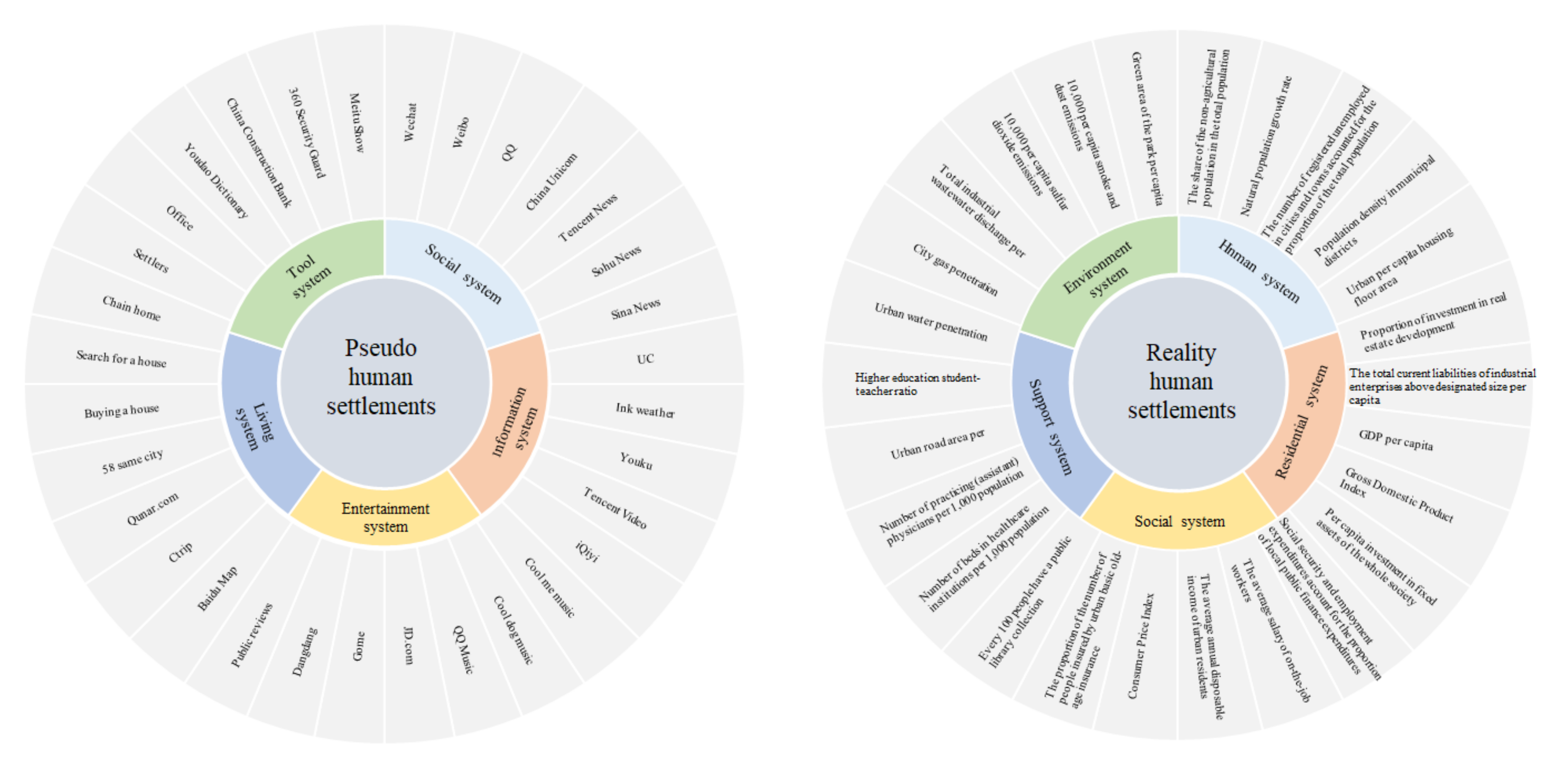
- The coupling coordination among elements refers to the fact that elements within each subsystem in the five major systems are related to each other and influence each other through interaction, which are the full and unnecessary conditions of human settlements system coupling coordination. Elements and coupling coordination refers to the human settlements system internal relations between single and multiple elements, such as the RHSs within the state in the social system of urban social and economic development level and the coupling coordination interaction between the on-the-job worker average wage level, or the environment in the state system and coupling coordination relation between residential system [50].
- (2)
- The coupling coordination among system and system refers to the relationship between the whole human settlements system and another system, such as the coupling coordination between social system in reality state and travel of life system in pseudo state. For example, the coupling coordination of five subsystems in human settlements [45].
- (3)
- The coupling coordination of the two states refers to the interactive relationship of mutual integration and mutual stress in the urban human settlements system at different states, which can be divided into reality and pseudo, reality and imagery, and pseudo and imagery. For example, the relationship between informatization and economic society represents the coupling between pseudo and reality [38].
- (4)
- The coupling coordination among the three states, the interaction among reality, pseudo and imagery, which not only has the coupling stress between the single system and other elements but also includes the coupling stress between the system and the external system. The process of “three states” from single element or single state to multi-element and multi-state does not exist in isolation but is a spiral development process from disorder to orderly arrangement and combination between various states, which jointly affects the urban human settlements.
2.2. Theoretical System
2.3. Data Sources
2.4. Methods
2.4.1. Data Preprocessing
2.4.2. Coupling Coordination
2.4.3. Spatial Trend Surface
2.4.4. Geographic Detector
3. Results
3.1. Spatio-Temporal Characteristics of Coupling Coordination Degree
3.1.1. Time Process Characteristics of Coordination Degree
3.1.2. Spatial Pattern Characteristics of Coordination Degree
- (1)
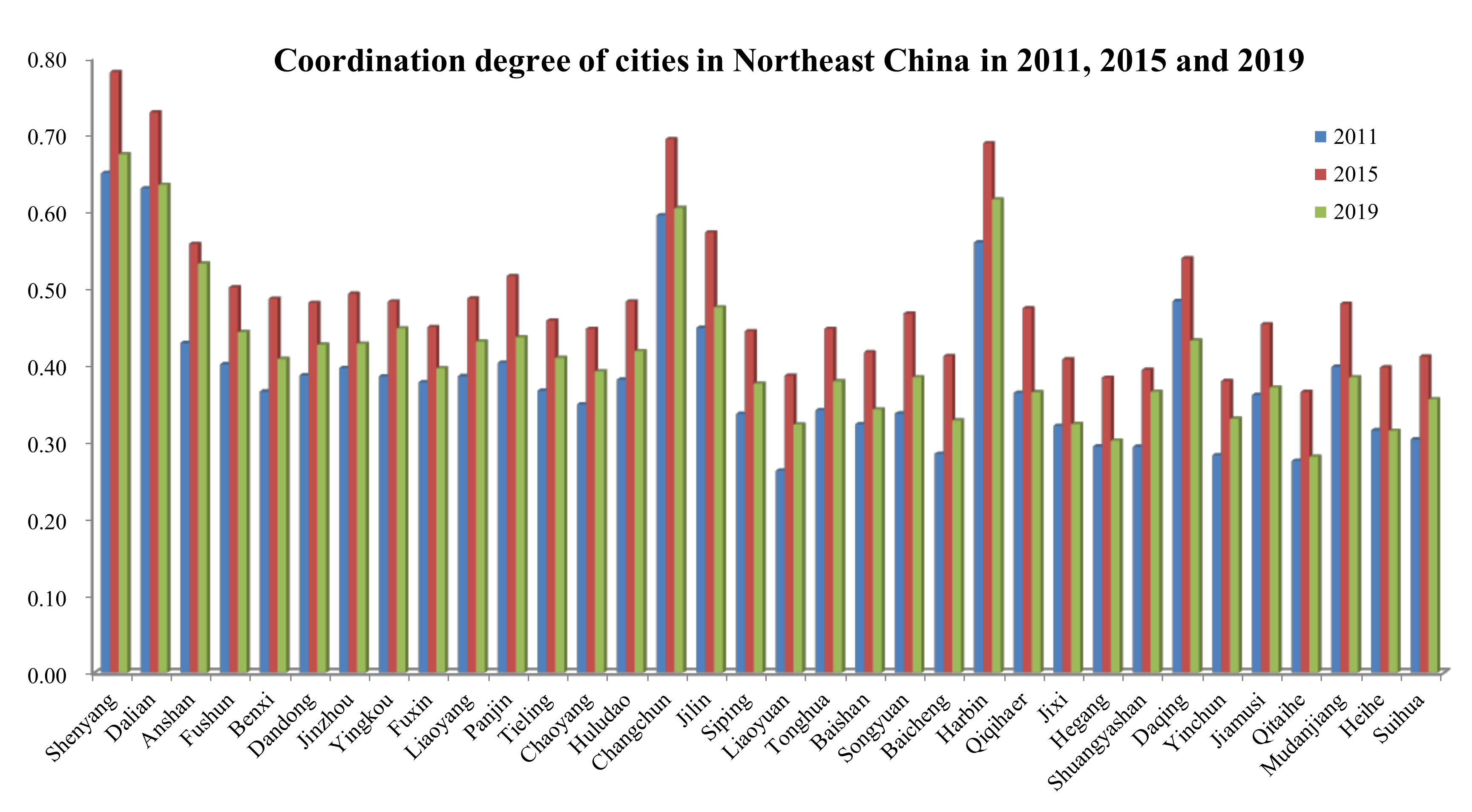
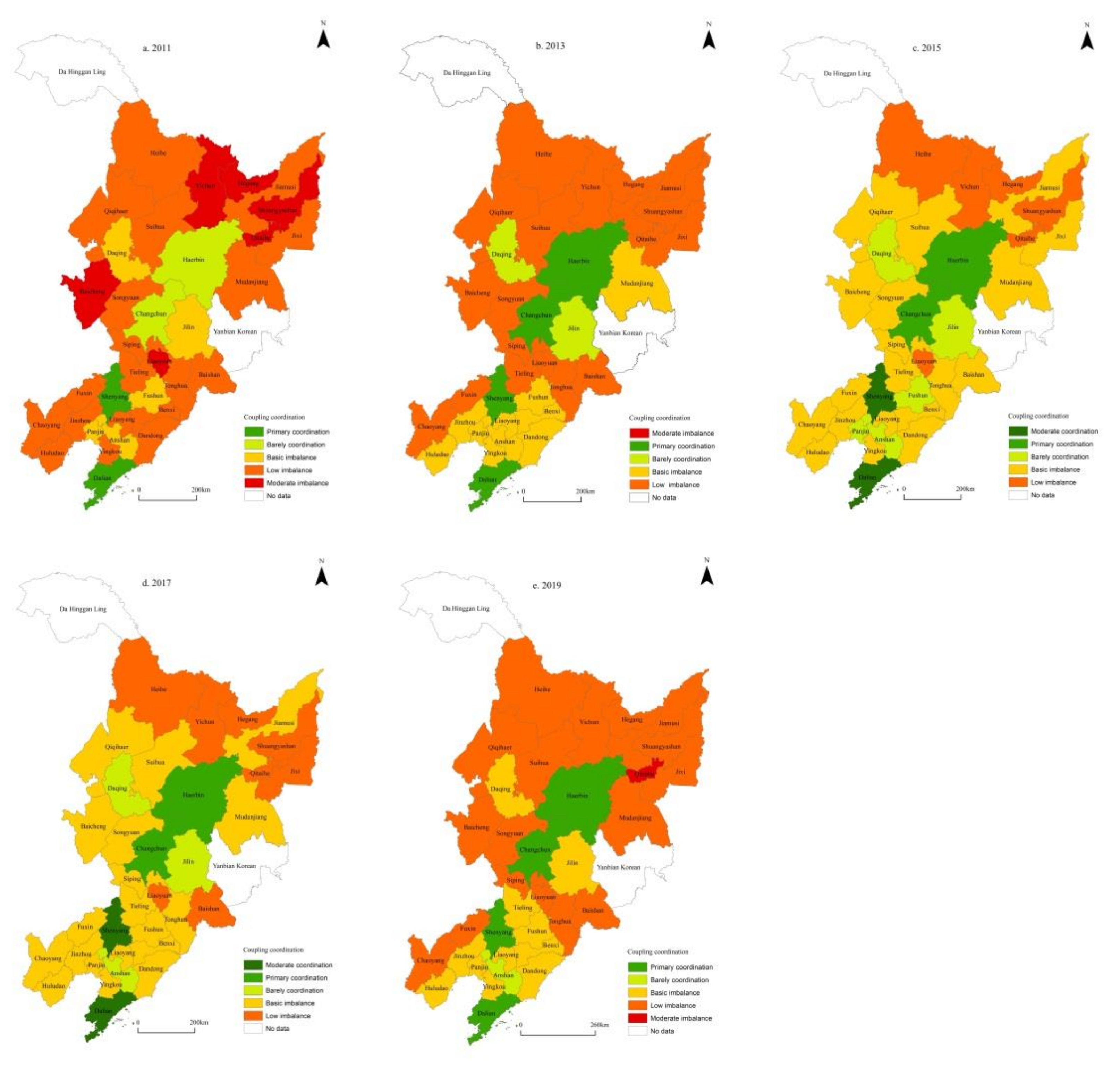
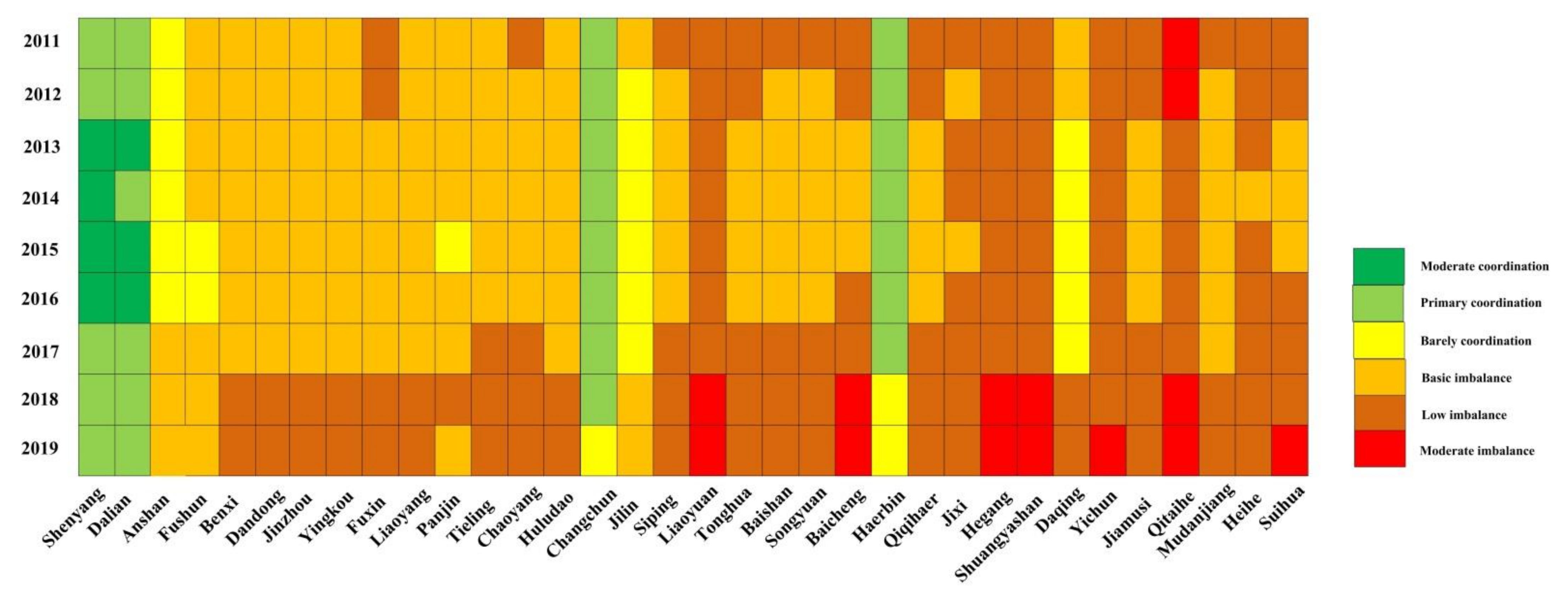
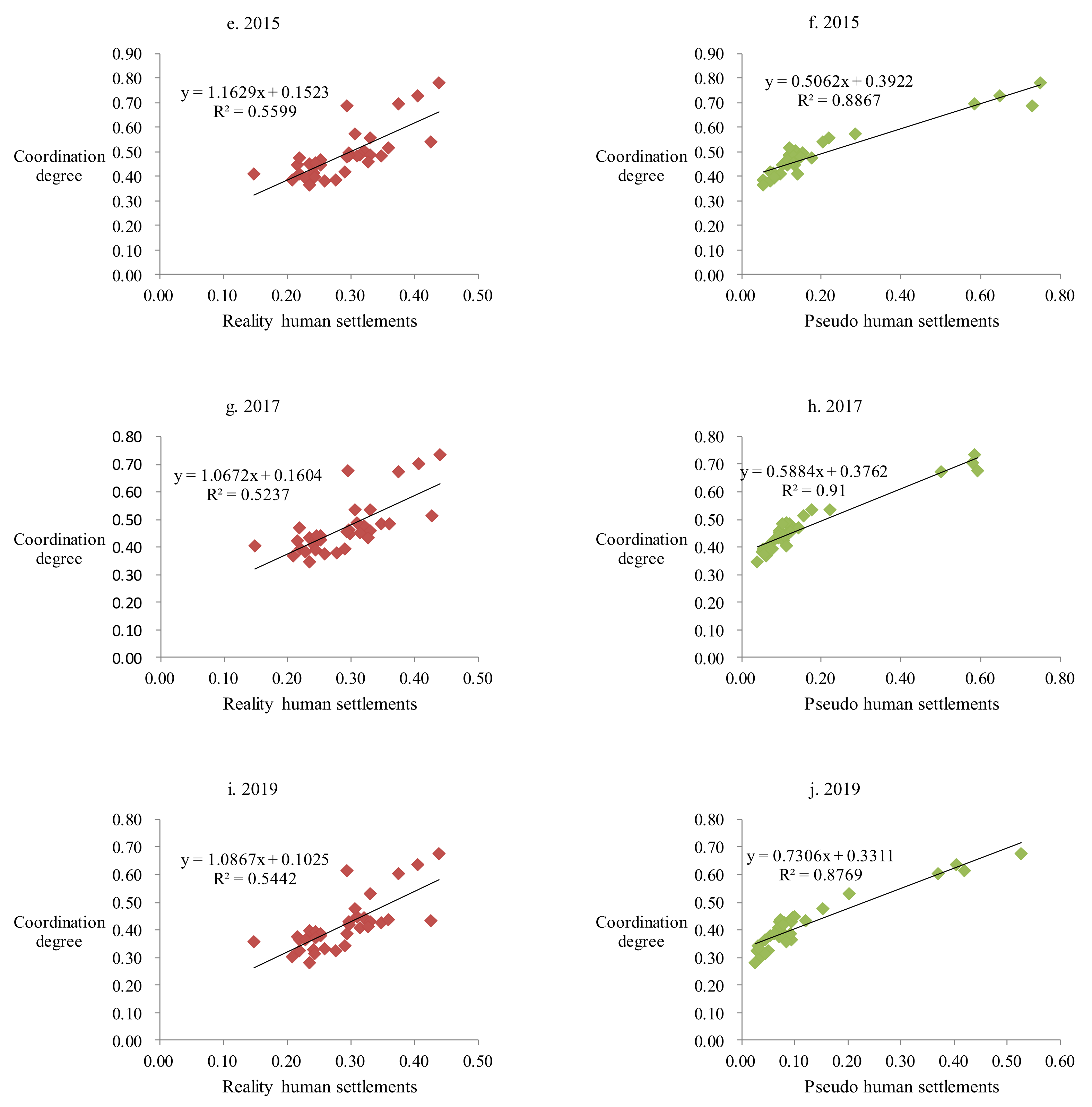
- In terms of spatial dimension, the coordination degree of urban PHSs and RHSs in the three provinces of northeast China has significant spatio-temporal heterogeneity [59], showing a typical north–south spatial heterogeneity characteristic of “low in the north and high in the south” (Figure 6). Regarding the overall characteristics, from 2011 to 2019, the coordination degree among PHSs and RHSs in 34 cities in northeast China shows a sharp upward trend, with a total growth rate of 3.05%. From 2011 to 2015, the growth rate reaches 2.26%, and the cities with a large growth rate are mainly distributed in Shenyang and Songyuan, with a growth rate of 31.43% and 30.24%, respectively. From 2015 to 2019, a large area of negative growth occurs, with a growth rate of −5.19%. Anshan city has the largest growth rate of 0.84%, and Qiqihar city has the lowest growth rate of −10.56%. There is a big difference in the coordination degree among PHSs and RHSs.
- (2)
- Regional characteristics: from 2011 to 2019, the coupling coordination degree among PHSs and RHSs and the political center exists in spatial alignment. The coupling coordination degree among urban PHSs and RHSs shows a “southward advance” phenomenon, presenting a typical north–south spatial heterogeneity characteristic of “low in the north and high in the south”. From 2011 to 2019, the average coordination degree of urban PHSs and RHSs is Liaoning (0.47) > Jilin (0.43) > Heilongjiang (0.40), and the average coordination degree of provincial capital cities is Shenyang (0.70) > Changchun (0.65) > Harbin (0.64). Although all provinces and cities increased in different degrees in the past 9 years, the provincial characteristics of “low in the north and high in the south” remained relatively stable and showed a spatial evolution pattern of accelerating “southward advance”.
- (3)
- Typical features of typical cities: through coupling system degree analysis, the coupling coordination characteristics of typical urban PHSs and RHSs are revealed. The results showed that the threshold values of urban coupling coordination degree of Shenyang and Dalian in Liaoning Province from 2011 to 2019 are [0.60, 0.80], both at the coordination level. Shenyang is the most typical among the typical cities, and the mean value of coupling coordination degree in 9 years is 0.70, which is 0.02 higher than the mean value of Dalian. It ranks first in the coupling model of PHSs and RHSs in 34 cities, among which 2011–2013 belonged to primary coordination, 2014–2017 belonged to intermediate coordination, 2018–2019 belonged to primary coordination, and it is still in high-level coordination despite a certain period of fluctuation. Shenyang leads other cities in the province to good coordination, intermediate coordination and the majority of the primary coordination.
3.2. Type Characteristics of Coupling Coordination Degree
3.2.1. The Core Zone
3.2.2. The Transition Zone
3.2.3. The marginal Area
3.3. The Trend Side of Coordination
- (1)
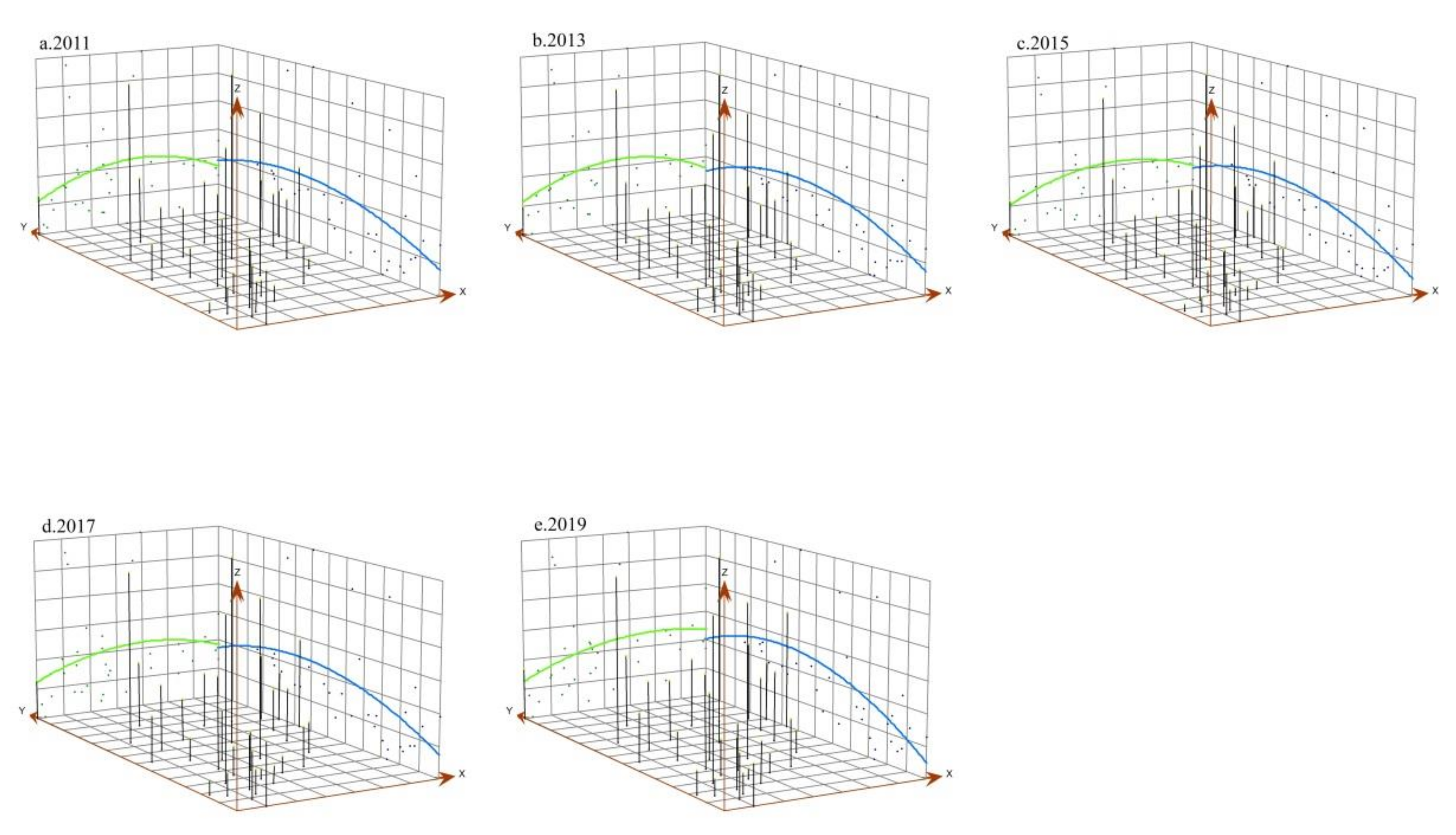
- In general, the spatial distribution pattern is low in the east and west, high in the middle, showing an inverted “U” shaped spatial trend, and gentle in the north and south directions. Except for the existence of one or two poles, the coupling coordination degree of urban PHSs and RHSs has a balanced influence.
- (2)
- In the direction of south and north, the spatial evolution trend shows a gradual change from “—” shape to “U” shape, indicating that the gap among urban PHSs and RHSs is gradually narrowing in the south, north and central regions. The spatial trends in 2011, 2013, 2015, 2017 and 2019 were relatively consistent, indicating that the spatial variation range of coordination degree of human settlements in northeast China was small, showing a stable development trend.
- (3)
- In the east–west direction, the trend surface changes from inverted “U” shape to “—” shape, which shows that the coupling coordination degree of the northern region is gradually lower than that of the southern region, indicating that the coordination degree of PHSs and RHSs in the three provinces of northeast China presents a stable north–south spatial heterogeneity characteristic of “low in the north and high in the south”.
3.4. Driving Principle of Coupling Coordination Degree
3.4.1. Factor Analysis
3.4.2. System Analysis
3.4.3. State Analysis
3.4.4. Research on Principle
4. Discussion
4.1. Contribution of This Study
- 1.
- Theoretical contribution: this paper constructs the dynamic framework of the “three state” urban human settlements in order to enrich the existing research on human settlements, promote the development and improvement of the coupling and coordination of the complex system of human land relations, and provide theoretical support for the coupling mechanism of the “three state” urban human settlements.
- 2.
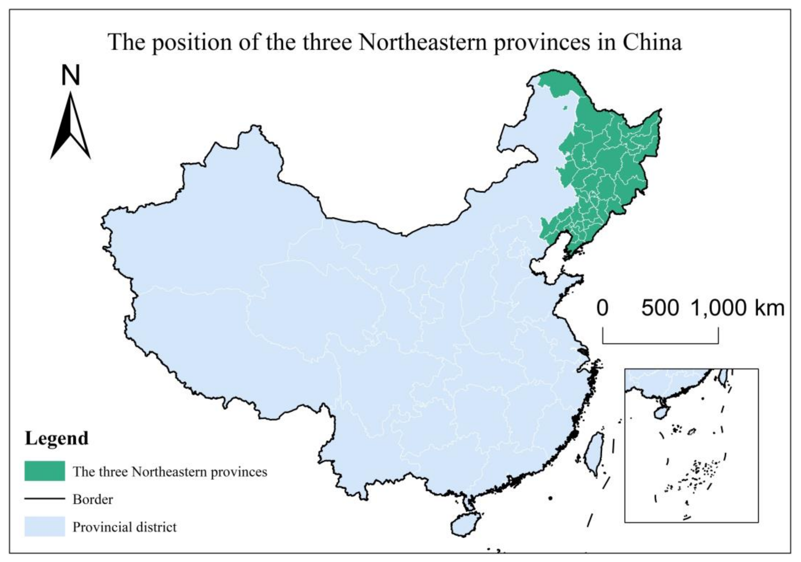
- Empirical contribution: northeast China is a typical region with unbalanced and insufficient development in China. There are old problems of RHSs and a new pattern of new changes in pseudo human settlements. At the same time, pseudo human settlements are seriously incompatible with reality. Therefore, choosing the three northeastern provinces as the research object is representative in regional research. Through objective understanding, we found targeted local empirical suggestions to promote the revitalization and high-quality development of northeast China.
4.2. The Limitations and Research Trends of the Article
- (1)
- This paper only studies the coupling and coordination among PHSs and RHSs, but it does not accord with the development prospect of three-dimensional reality, pseudo and imagery. In the future, the research form tends to be polymorphic, the research content is deepened vertically, and the coupling and coordination between pseudo and reality is transformed into reality–pseudo–imagery coupling and coordination.
- (2)
- The research only involves 34 cities in northeast China and does not involve meso and micro scales such as Liaoning Province and Dalian. In the future, fine research will be carried out. There will be more detailed research. The scale tends to be more micro, and the research object is oriented to the needs of specific groups.
- (3)
- The research only pays attention to theory and does not discuss it closely with practice. Based on theory, pay attention to the theoretical connotation of research, integrate the theoretical framework and system structure, promote the practice and innovative development of new theories such as interdisciplinary and polymorphic coupling theory, and realize a multi-scale and three-dimensional urban PHSs and RHSs non-linear interactive coupling network system facing urban practical problems.
- (4)
- The research data are missing in two regions. In the future, take the data as the support, promote the high-quality integration of multi-source data, and extract key and accurate information.
- (5)
- The research should be guided by the actual problem needs, improve the information integration logic, scientifically layout the industrial structure, develop an intelligent service platform, make urban governance smarter and urban planning more accurate, and provide decision support for the high-quality development of urban human settlements.
4.3. Policy Implication
- (1)
- Coordination and cooperation, reality and pseudo industry integration development. According to the “14th Five-year Plan”, the revitalization of northeast China should speed up the way of urban transformation, strengthen the ability of regional cooperation, close contact and cooperation with surrounding cities in the information age, stimulate the potential of consumer market, and drive economic development. In southeast coastal areas with a high coupling coordination degree, coastal cities should continue to give full play to their advantages and eliminate industries with high consumption and low efficiency. They should also intensify the development of financial industry, give full play to the advantages of eco-tourism and high-skilled labor agglomeration, and improve the coupling coordination level of urban PHSs and RHSs local and surrounding areas.
- (2)
- Multi-regional linkage promotes the coordinated development of PHSs and RHSs in the three northeastern provinces. Make use of the “core area”, drive the “transition area”, improve the “marginal area” environment, and promote inter-provincial cooperation. Strengthen the multi-party linkage between people and information flow, data flow and artificial intelligence, and build a high-quality coordination relationship between people and cities.
- (3)
- Collaborate across regions to reduce regional differences. The region in the transition period of coupling coordination in the central region, adjacent to the southern provincial capital and the economically developed coastal cities, is in an awkward transition region. Internally, it should give full play to its development advantages of abundant labor force, carry out cross-regional cooperation, improve the level of urbanization, and reduce regional differences. A lower area northwest coupling coordination degree should vigorously improve the transportation infrastructure facilities, according to introspection on the development of the present situation, the corresponding urban planning and policy, adjustment of measures to local conditions for their building of characteristic industry, taking urban PHSs and RHSs, the interaction of the two systems and the regional development, bringing city attraction, and gradually narrowing provincial differences for the revitalization of the northeast China to make a beneficial contribution.
5. Conclusions
Author Contributions
Funding
Institutional Review Board Statement
Informed Consent Statement
Data Availability Statement
Conflicts of Interest
References
- Doxiadis, C.A. Ekistics, the Science of Human Settlements. Cities 1970, 170, 3956. [Google Scholar] [CrossRef] [PubMed]
- Li, X.; Li, H.; Li, J.; Zhang, Y. Geographical Research of Human Settlements from Positivionsm to Humanism; Science Press: Beijing, China, 2015. [Google Scholar]
- Guerra, J.B.S.O.; Hoffmann, M.; Bianchet, R.T.; Medeiros, P.; Provin, A.P.; Iunskovski, R. Sustainable development goals and ethics: Building “the future we want”. Environ. Dev. Sustain. 2021, 1–22. [Google Scholar] [CrossRef]
- Kaseva, M.E. The African city in sustainable human settlement development: A case of urban waste management in Dar es Salaam. J. S. Afr. Inst. Civ. Eng. 1999, 1999, 26–30. [Google Scholar]
- Mathee, A.; Moyes, J.; Mkhencele, T.; Kleynhans, J.; Piketh, S.; Moroe, E.; Wafawanaka, F.; Martinson, N.; McMorrow, M.; Tempia, S.; et al. Housing quality in a rural and an urban settlement in South Africa. Int. J. Environ. Res. Public Health 2021, 18, 2240. [Google Scholar] [CrossRef] [PubMed]
- Egidi, G.; Halbac-Cotoara-Zamfir, R.; Cividino, S.; Quaranta, G.; Salvati, L.; Colantoni, A. Rural in town: Traditional agriculture, population trends, and long-term urban expansion in metropolitan rome. Land 2020, 9, 53. [Google Scholar] [CrossRef]
- Jiaming, L.; Yu, Y.; Jie, F.; Fengjun, J.; Wenzhong, Z.; Shenghe, L.; Bojie, F. Comparative research on regional differences in urbanization and spatial evolution of urban systems between China and India. J Geogr. Sci. 2017, 72, 986–1000. [Google Scholar] [CrossRef]
- Salmon, B.P.; Olivier, J.C.; Kleynhans, W.; Wessels, K.J.; Van den Bergh, F.; Steenkamp, K.C. The use of a Multilayer Perceptron for detecting new human settlements from a time series of MODIS images. Int. J. Appl. Earth Obs. 2011, 13, 873–883. [Google Scholar] [CrossRef]
- Wu, L. Search for the theory of human settlement. Planners 2001, 17, 5–8. [Google Scholar]
- Li, X.; Hu, X.; Shi, Y.; Yang, H. The role of rural settlements in rural revitalization: Perspective of economic geography. Prog. Geogr. 2021, 40, 3–14. [Google Scholar] [CrossRef]
- Chan, E.H.; Tang, B.S.; Wong, W.S. Density control and the quality of living space: A case study of private housing development in Hong Kong. Habitat Int. 2002, 26, 159–175. [Google Scholar] [CrossRef]
- Acai, A.; Sonnadara, R.; O’Neill, T. Getting with the times: A narrative review of the literature on group decision making in virtual environments and implications for promotions committees. Perspect. Med. Educ. 2018, 7, 147–155. [Google Scholar] [CrossRef] [PubMed]
- Chen, C.; Zhang, W.; Zhan, D.; Li, X. Quantitative evaluation of human settlement environment and influencing factors in the Bohai Rim area. Prog. Geogr. 2017, 36, 1562–1570. [Google Scholar] [CrossRef]
- Yigitcanlar, T.; Kamruzzaman, M.; Foth, M.; Sabatini-Marques, J.; da Costa, E.; Ioppolo, G. Can cities become smart without being sustainable? A systematic review of the literature. Sustain. Cities Soc. 2019, 45, 348–365. [Google Scholar] [CrossRef]
- Robert, L. A primer of knowledge management for smart city governance. Land Use Policy 2021, 111, 104832. [Google Scholar] [CrossRef]
- David, A.P.; Wangshu, M. A people-based density perspective on physical/virtual world spaces in the microcosmic city. Land Use Policy 2021, 111, 104462. [Google Scholar] [CrossRef]
- Jimin, L.; Yun-Gyeong, O.; Seung-Hwan, Y.; Kyo, S. Vulnerability assessment of rural aging community for abandoned farmlands in South Korea. Land Use Policy 2021, 108, 105544. [Google Scholar] [CrossRef]
- Wang, Y.; Yang, S.; Wu, L. Heterogeneity for urban human settlements demand from the perspective of multiple subjects: A case study of Kunshan economic and technological development zone. Sci. Geogr. Sin. 2018, 38, 1156–1164. [Google Scholar] [CrossRef]
- Jonas, E. Urbanization in Nigeria, Enugu (the coal city) as an urban town: A historical review. Cities 2021, 113, 103096. [Google Scholar] [CrossRef]
- Yu, H.; Fan, Z.; Wen, Z.; Song, G.; Jinmeng, R.; Fabio, D.; Carlo, R. Understanding house price appreciation using multi-source big geo-data and machine learning. Land Use Policy 2021, 111, 104919. [Google Scholar] [CrossRef]
- Aliu, I.R.; Akoteyon, I.S.; Soladoye, O. Living on the margins: Socio-spatial characterization of residential and water deprivations in Lagos informal settlements, Nigeria. Habitat Int. 2021, 107, 102293. [Google Scholar] [CrossRef]
- Zhang, H.; Ning, X.; Wang, H.; Shao, Z. High accuracy urban expansion monitoring and analysis of China’s provincial capitals from 2000 to 2015 based on high-resolution remote sensing imagery. Acta Geogr. Sin. 2018, 73, 2345–2363. [Google Scholar] [CrossRef]
- Jinglu, S.; Rishikesh, P.; Guan, D.; Ayyoob, S.; Bhim, P.S. Urban-Rural Disparity in Community Resilience: A Multilevel Analysis of the Relief Progress after the 2015 Nepal Earthquake. Sustain. Cities Soc. 2022, 79, 103698. [Google Scholar] [CrossRef]
- Raana, S.B. A multifaceted study of place attachment and its influences on civic involvement and place loyalty in Baharestan new town, Iran. Cities 2020, 96, 102473. [Google Scholar] [CrossRef]
- Kang, Y.; Zhang, F.; Gao, S.; Peng, W.; Carlo, R. Human settlement value assessment from a place perspective: Considering human dynamics and perceptions in house price modeling. Cities 2021, 118, 103333. [Google Scholar] [CrossRef]
- Alessandro, V.; Iovene, M.; Giovanni, F. Exploring the similarities between informal and medieval settlements: A methodology and an application. Cities 2021, 115, 103211. [Google Scholar] [CrossRef]
- Wei, W.; Shi, P.; Zhou, J.; Feng, H.; Wang, X.; Wang, X. Environmental suitability evaluation for human settlements in an arid inland river basin: A case study of the Shiyang River Basin. J. Geogr. Sci. 2013, 23, 331–343. [Google Scholar] [CrossRef]
- Zhao, Z.; Sharifi, A.; Dong, X.; Shen, L.; He, B. Spatial Variability and Temporal Heterogeneity of Surface Urban Heat Island Patterns and the Suitability of Local Climate Zones for Land Surface Temperature Characterization. Remote Sens. 2021, 13, 4338. [Google Scholar] [CrossRef]
- Zhao, Z.; He, B.; Li, L.; Wang, H.; Darko, A. Profile and concentric zonal analysis of relationships between land use/land cover and land surface temperature: Case study of Shenyang, China. Energy Build. 2017, 155, 282–295. [Google Scholar] [CrossRef]
- Yu, H.; Yang, J.; Sun, D.; Li, T.; Liu, Y. Spatial Responses of Ecosystem Service Value during the Development of Urban Agglomerations. Land 2022, 11, 165. [Google Scholar] [CrossRef]
- Zhao, D.; Wang, J.; Zhao, X.; Triantafilis, J. Clay content mapping and uncertainty estimation using weighted model averaging. Catena 2022, 209, 105791. [Google Scholar] [CrossRef]
- Luo, X.; Yang, J.; Sun, W.; He, B. Suitability of human settlements in mountainous areas from the perspective of ventilation: A case study of the main urban area of Chongqing. J. Clean. Prod. 2021, 310, 127467. [Google Scholar] [CrossRef]
- Xin, Q.; Zhen, F.; Xiong, L.; Zhu, S. Methods in urban temporal and behavior in the era of big data. Prog. Geogr. 2013, 32, 1352–1361. [Google Scholar] [CrossRef]
- Wu, W.; Wang, J.; Dai, T. The geography of cultural ties and human mobility: Big data in urban contexts. Ann. Am. Assoc. Geogr. 2016, 106, 612–630. [Google Scholar] [CrossRef]
- Hao, J.; Zhu, J.; Zhong, R. The rise of big data on urban studies and planning practice in China: Review and open research issue. J. Urban Manag. 2015, 4, 92–124. [Google Scholar] [CrossRef]
- Rathore, M.M.; Ahmad, A.; Paul, A.; Rho, S. Urban planning and building smart cities based on the Internet of things using Big Data analytics. Comput. Netw. 2016, 101, 63–80. [Google Scholar] [CrossRef]
- Tian, S.; Qi, A.; Li, Z.; Pan, X.; Liu, Y.; Li, X. Urban “three states” human settlements high-quality. Building 2022, 12, 178. [Google Scholar] [CrossRef]
- Tian, S.; Li, X.; Yang, J.; Wang, H.; Guo, J. Spatio-Temporal Evolution of Pseudo Human Settlements: Case Study of 36 Cities in the three provinces of Northeast China from 2011 to 2018. Environ. Dev. Sustain. 2022, 24, 1–31. [Google Scholar] [CrossRef]
- Tian, S.; Li, X.; Yang, J.; Zhang, W.; Guo, J. Spatial-temporal coupling coordination and driving mechanism of urban pseudo and reality human settlements in the three provinces of Northeast China. Acta Geogr. Sin. 2021, 76, 781–798. [Google Scholar] [CrossRef]
- Zhou, D.; Wang, C. Specific evaluation of resource and environmental carrying capacity of urbanized areas for early-warning: A case study of the Beijing-Tianjin-Hebei region. Prog. Geogr. 2017, 36, 359–366. [Google Scholar] [CrossRef][Green Version]
- Wu, X.; Zhang, Y.; Wu, B.; Zhang, Y.; Fang, G.; Qin, S. Study on the settlement pattern in sandy area and its quality evaluation: A case study of sandy area in the north of Yanchi County. Geogr. Res. 2010, 29, 1683–1694. [Google Scholar] [CrossRef]
- Wang, S.; Cui, Z.; Lin, J.; Xie, J.; Su, K. Coupling relationship between urbanization and ecological resilience in the Pearl River Delta. Acta Geogr. Sin. 2021, 76, 973–991. [Google Scholar] [CrossRef]
- Xiao, Q.; Xiao, L. Spatio-temporal differentiation and response of coupling and coordination between green innovation efficiency and ecological governance performance: A case of 108 cities in the Yangtze River Economic Belt. World Reg. Stud. 2022, 31, 1–12. [Google Scholar] [CrossRef]
- Li, X.; Zhang, C.; Zhou, L.; Yang, J. Response of Urban Man-made Landscape to urbanization on: The case of Dalian. Geogr. Res. 2005, 24, 785–793. [Google Scholar] [CrossRef]
- Li, X.; Guo, Y.; Tian, S.; Bai, Z.; Liu, H. The Spatio-temporal Pattern Evolution and Driving Force of the Coupling Coordination Degree of Urban Human Settlements System in Liaoning. Sci. Geogr. Sin. 2019, 39, 1208–1218. [Google Scholar] [CrossRef]
- Wang, F.; An, L.; Dang, A.; Han, J.; Miao, C.; Wang, J.; Zhang, G.; Zhao, Y. Human-land coupling and sustainable human settlements in the Yellow River Basin. Geogr. Res. 2020, 39, 1707–1724. [Google Scholar] [CrossRef]
- Zhang, Y.; Li, X.; Xia, C. Spatial pattern of coupling development between real estate development and housing condition at prefectural level in China. Prog. Geogr. 2014, 33, 232–240. [Google Scholar] [CrossRef]
- Fu, B. Geography: From knowledge, science to decision making support. Acta Geogr. Sin. 2017, 72, 1923–1932. [Google Scholar] [CrossRef]
- Huang, J.; Na, Y.; Guo, Y. Spatiotemporal characteristics and driving mechanism of the coupling coordination degree of urbanization and ecological environment in Kazakhstan. J. Geogr. Sci. 2020, 30, 1802–1824. [Google Scholar] [CrossRef]
- Gao, J.; Li, S.; Li, X.M.; Yang, J. Review on city square and human settlements environment: A quantitative analysis based on CiteSpace. Sci. Geogr. Sin 2021, 41, 481–492. [Google Scholar] [CrossRef]
- Ma, H.; Liu, H.; Zhang, F. A review on relationships between urbanization and eco-environment in different spatial scales. World Reg. Stud. 2018, 27, 60–70. [Google Scholar]
- Ma, E.; Cai, J.; Guo, H.; Lin, J.; Liao, L.; Han, Y. Theoretical framework and research priorities on food system couplings in an urbanization context. Acta Geogr. Sin. 2021, 76, 2343–2359. [Google Scholar] [CrossRef]
- Pu, R.; Tao, Z.; Li, T. The spatio-temporal evolution of degree of coordination between tourism competitiveness and tourism service exports of major countries along the “Belt and Road”. World Reg. Stud. 2021, 30, 948–956. [Google Scholar] [CrossRef]
- Wang, L.; Wang, T.; Zhang, H. The spatio-temporal heterogeneity of the driving factors of urban ambidextrous innovation: Taking the coupling divisions of biomedical multi-innovation elements as an example. Sci. Geogr. Sin. 2021, 41, 1556–1568. [Google Scholar] [CrossRef]
- Ren, Y.; Fang, C.; Sun, S.; Bao, C.; Liu, R. Progress in local and tele-coupling relationship between urbanization and eco-environment. Acta Geogr. Sin. 2020, 75, 589–606. [Google Scholar] [CrossRef]
- Cong, X. Expression and mathematical property of coupling model, and its misuse in geographical science. Econ. Geogr. 2019, 39, 18–25. [Google Scholar] [CrossRef]
- Peng, J.; Yang, M.; Liang, H.; Wang, S.; Dai, C. Analysis on the Spatial Trend-Surface of Bajiang Karst Catchment in Lunan‚ Yunan Province. Geogr. Geo. Inf. Sci. 2005, 21, 109–112. [Google Scholar]
- Wang, J.; Xu, C. Geodetector: Principle and prospective. Acta Geogr. Sin. 2017, 72, 116–134. [Google Scholar] [CrossRef]
- Wang, C.; Tang, N. Spatio-temporal characteristics and evolution of rural production living-ecological space function coupling coordination in Chongqing Municipality. Geogr. Res. 2018, 37, 1100–1114. [Google Scholar] [CrossRef]

| Coupling Degree | C | Coordination Degree | D | Coupling Degree | C | Coordination Degree | D |
|---|---|---|---|---|---|---|---|
| High level coupling | 0.8 < C ≤ 1 | Advanced | 0.90 < D ≤ 1.00 | Antagonism phase | 0.3 < C ≤ 0.5 | Basic | 0.40 < D ≤ 0.50 |
| Good | 0.80 < D ≤ 0.90 | Mild | 0.30 < D ≤ 0.4 | ||||
| Running-in stage | 0.5 < C ≤ 0.8 | Moderate | 0.70 < D ≤ 0.80 | Low level coupling | 0 < C ≤ 0.3 | Moderate | 0.20 < D ≤ 0.30 |
| Primary | 0.60 < D ≤ 0.70 | serious | 0.10 < D ≤ 0.20 | ||||
| Barely | 0.50 < D ≤ 0.60 | Extreme | 0.00 < D ≤ 0.10 |
| Pseudo | 2011 | 2013 | 2015 | 2017 | 2019 | Reality | 2011 | 2013 | 2015 | 2017 | 2019 |
|---|---|---|---|---|---|---|---|---|---|---|---|
| PHS1 | 0.7446 | 0.9795 | 0.9783 | 0.9721 | 0.9564 | RHS1 | 0.2121 | 0.2685 | 0.2319 | 0.3752 | 0.2542 |
| PHS2 | 0.9759 | 0.9743 | 0.9798 | 0.9718 | 0.9507 | RHS2 | 0.4544 | 0.3342 | 0.5422 | 0.4734 | 0.1462 |
| PHS3 | 0.7978 | 0.9729 | 0.9806 | 0.9757 | 0.9651 | RHS3 | 0.2466 | 0.2804 | 0.4479 | 0.4877 | 0.6068 |
| PHS4 | 0.9628 | 0.9832 | 0.9888 | 0.9714 | 0.9582 | RHS4 | 0.3921 | 0.3865 | 0.2232 | 0.3406 | 0.4514 |
| PHS5 | 0.7377 | 0.9516 | 0.9928 | 0.9850 | 0.9478 | RHS5 | 0.5052 | 0.5903 | 0.4936 | 0.3510 | 0.1816 |
| PHS6 | 0.8052 | 0.9547 | 0.9826 | 0.9755 | 0.9206 | RHS6 | 0.2716 | 0.3048 | 0.2361 | 0.2953 | 0.3097 |
| PHS7 | 0.9661 | 0.9801 | 0.9873 | 0.9774 | 0.9563 | RHS7 | 0.3720 | 0.4463 | 0.4676 | 0.3745 | 0.4357 |
| PHS8 | 0.9554 | 0.9655 | 0.9728 | 0.9690 | 0.9503 | RHS8 | 0.3008 | 0.3206 | 0.3264 | 0.3301 | 0.3858 |
| PHS9 | 0.8637 | 0.9295 | 0.9283 | 0.9526 | 0.9353 | RHS9 | 0.5505 | 0.4527 | 0.3996 | 0.4778 | 0.3667 |
| PHS10 | 0.9694 | 0.9828 | 0.9880 | 0.9887 | 0.9700 | RHS10 | 0.4845 | 0.4047 | 0.3540 | 0.2889 | 0.2119 |
| PHS11 | 0.9926 | 0.9847 | 0.9860 | 0.9708 | 0.9836 | RHS11 | 0.2436 | 0.0835 | 0.1095 | 0.1810 | 0.3275 |
| PHS12 | 0.9833 | 0.9847 | 0.9807 | 0.9724 | 0.9340 | RHS12 | 0.2909 | 0.2257 | 0.2800 | 0.2613 | 0.3292 |
| Pseudo | 2011 | 2013 | 2015 | 2017 | 2019 | Reality | 2011 | 2013 | 2015 | 2017 | 2019 |
|---|---|---|---|---|---|---|---|---|---|---|---|
| Society | 0.8024 | 0.9782 | 0.9787 | 0.9720 | 0.9550 | Human | 0.2928 | 0.2904 | 0.3354 | 0.4079 | 0.2515 |
| Information | 0.8671 | 0.9788 | 0.9833 | 0.9769 | 0.9646 | Settlement | 0.3436 | 0.3511 | 0.2981 | 0.3896 | 0.5032 |
| Entertainment | 0.7714 | 0.9531 | 0.9877 | 0.9803 | 0.9342 | Society | 0.3941 | 0.4628 | 0.4248 | 0.3491 | 0.3230 |
| Living | 0.9208 | 0.9554 | 0.9591 | 0.9650 | 0.9460 | Support | 0.4508 | 0.3944 | 0.3591 | 0.3547 | 0.3058 |
| Tool | 0.9769 | 0.9838 | 0.9842 | 0.9775 | 0.9615 | Environment | 0.2791 | 0.1902 | 0.2374 | 0.2413 | 0.3007 |
Publisher’s Note: MDPI stays neutral with regard to jurisdictional claims in published maps and institutional affiliations. |
© 2022 by the authors. Licensee MDPI, Basel, Switzerland. This article is an open access article distributed under the terms and conditions of the Creative Commons Attribution (CC BY) license (https://creativecommons.org/licenses/by/4.0/).
Share and Cite
Tian, S.; Yang, B.; Liu, Z.; Li, X.; Zhang, W. Coupling Coordination of Urban Pseudo and Reality Human Settlements. Land 2022, 11, 414. https://doi.org/10.3390/land11030414
Tian S, Yang B, Liu Z, Li X, Zhang W. Coupling Coordination of Urban Pseudo and Reality Human Settlements. Land. 2022; 11(3):414. https://doi.org/10.3390/land11030414
Chicago/Turabian StyleTian, Shenzhen, Bing Yang, Zhangli Liu, Xueming Li, and Wei Zhang. 2022. "Coupling Coordination of Urban Pseudo and Reality Human Settlements" Land 11, no. 3: 414. https://doi.org/10.3390/land11030414
APA StyleTian, S., Yang, B., Liu, Z., Li, X., & Zhang, W. (2022). Coupling Coordination of Urban Pseudo and Reality Human Settlements. Land, 11(3), 414. https://doi.org/10.3390/land11030414


