Article

Spatial Evolution and Driving Mechanism of City Networks in the Middle and Lower Ganges Valley from the 16th to the Mid-18th Century

1
Department of Architecture, School of Spatial Planning and Design, Zhejiang University City College, Hangzhou 310015, China
2
Department of Urban Planning, School of Architecture, Southeast University, Nanjing 210018, China
*
Author to whom correspondence should be addressed.
Land 2022, 11(11), 2016; https://doi.org/10.3390/land11112016
Submission received: 11 September 2022 / Revised: 3 November 2022 / Accepted: 5 November 2022 / Published: 11 November 2022

Abstract

:
The middle and lower Ganges Valley constitute an important part of the Asian economic and cultural corridor. Multicultural exchanges have had a profound impact on the development of historic cities and towns in the region. Considering the towns and cities of the middle and lower Ganges Valley from the 16th to the mid-18th century, this paper integrates the network theory and the centrifugal and centripetal force theory to explain how factors and forces have driven the spatial evolution of the regional urban system. By extracting spatiotemporal data from multiple sources, using the historical map translation method and spatial calculations based on GIS (Geographical Information System), the spatial pattern evolution of the city networks in this historical period is analyzed. The results show that centripetal and centrifugal forces that are generated by different driving factors combined to produce city networks in the middle and lower Ganges Valley from the 16th to the mid-18th century, forming a polycentric “axis network” spatial pattern with a stable and unified overall structure and dynamic and diverse local structures. The paper also argues that constant cultural and socioeconomic communication between the middle and lower Ganges Valley and the East is the key reason for the continuous expansion of the network.

1. Introduction

The International Council on Monuments and Sites issued The ICOMOS Charter on Cultural Routes in 2008, marking that cultural routes have officially become a new type of world heritage [1]. The middle and lower Ganges region is one of the birthplaces of urban civilization in South Asia and a key segment of Asian economic and cultural corridors. Many historic towns that have been built since the Middle Ages are closely related to historic routes such as the “Southern Silk Road” or the “Plateau Silk Road”. In contemporary times, most of the historic towns along these routes still play an important role in supporting the socioeconomic development of related countries and regions, but they are also facing the destruction of heritage under rapid urbanization and the loss of tradition under globalization. As Prasenjit Duara emphasizes, the traditional intra-Asian connections and networks have important significance for solving the crisis of modernity [2]. Therefore, studying the network of historic urban systems in the middle and lower Ganges Valley has practical value for cultural heritage conservation and sustainable development of South Asian cities and towns. From the internal view, as the core area of the Mughal territory (A.D. 1526–A.D. 1857), the Ganges River Valley experienced a construction boom from the 16th to the mid-18th century, and a regional network of cultural routes was formed with land and water routes serving as connecting lines, and towns, ports, castles, post stations and bridges serving as nodes. In this network, political power, money, products, culture and people kept flowing from one node to another along the routes. From the external view, after the Persians were defeated by the Mongols in the 13th century, Arabian maritime trade in Asia gradually declined, while China’s foreign trade developed during the Tang, Song and Yuan dynasties. By the time of the Ming dynasty (A.D. 1368–A.D. 1644), a complex tributary trading network was established in Asia and to some extent continued until the early Qing dynasty (A.D. 1636–A.D. 1912). This trading network was an important external environment for the development of towns in the middle and lower Ganges Valley. Therefore, this historical period was key for the formation of spatial patterns of the modern city networks in this region, which emphasized the importance of historical urban system research.
Since the 1930s and 1940s, the research of urban system has witnessed a paradigm shift from static top-down hierarchic models to dynamic, bottom-up nonhierarchic models [3]. Before the 1960s, the models based on theories such as the central place theory [4], the law of primate city [5] and Zipf’s law [6], as well as other models based on economics and social physics, have been basically static, macroscopic, aggregate and hierarchical urban system research models, mostly based on population and socioeconomic indicators to deduce the spatial pattern of urban system indirectly [3]. Since the 1960s, researchers have increasingly realized that cities are typical complex systems with characteristics such as openness, nonlinearity, comprehensiveness, randomness, hierarchy, dynamics and uncertainty [7,8,9]. Therefore, urban geographers have introduced system dynamics, the principle of maximum entropy and self-organizing theory and other multidisciplinary theoretical methods [10,11,12,13,14,15]. Various decentralized and dynamic spatial interaction and urban growth models have been established [16,17,18,19], and they have also promoted urban research from the macro level of using economic and demographic data to the micro level of acquiring spatial data.
At the dawn of the 21st century, the study of globalization, information technology and networking emerged; as a typical structural configuration and evolutionary model of the self-organizing theory, the concept of network has been applied to the study of urban systems [20,21,22,23]. This approach supplemented the existing paradigm of urban systems with an open, nonhierarchical and dynamic model. In a city network system, towns represent nodes (points); communication channels represent veins (lines); and diffusion areas represent the background (surfaces). Elements such as commodities, services, power, information or capital flow between nodes along the veins to realize multidimensional organic connections between cities and towns. However, current studies on city networks have always focused on a single dimension, such as the transportation or economic dimension, and the study of the integration of multidimensional networks has been insufficient. In addition, most scholars have considered networking to be a phenomenon in the advanced stage of urbanization in modern developed areas. Such empirical studies were conducted in Europe since the 1990s [23,24] and in the Yangtze River Delta in China in recent decades [25,26], but there have been few studies on the city networks of the Ganges Valley, and little attention has been given to historic city networks in preindustrial societies.
As early as the 1970s, Indian scholars indicated that Western theories based on central place theory had very limited explanatory power for the Indian urban system, which is characterized by obvious regional features and multiple cultural variables [27,28] (p. 9). Currently, Indian geographers have studied the structure of Indian urban systems using flow, network, graph theory and urban systems methods but are often faced with the difficulty of collecting the data needed to use these methods [29]. In other disciplines, the research results of Indian historical urban system mainly come from historians and archaeologists, but the use of historical data requires systematic sorting and comparison of a large number of scattered and spatiotemporal incoherent historical documents, so it is difficult to establish a dynamic model for quantitative research of historical urban systems. The time frame of this study is between the 16th to mid-18th century, which, for India, was the premodern era of the Mughal dynasty, before the British Indian period with substantial growth in statistics. In fact, for this period, the concept of cultural routes gives us an appropriate perspective to understand the network of historical towns and obtain historical spatial data. The definition of cultural routes in the World Heritage Convention has indicated that these routes have both tangible and intangible properties and has suggested that they should be identified as a holistic dynamic system rather than simply regarded as “linear” or “nonlinear” cultural landscapes [1]. The historical cultural routes of the middle and lower Ganges Valley are intricate and complex. In fact, the term “a network of cultural routes” can better describe the characteristics of these multiroute and multidimensional network systems, while transportation networks or city networks in these systems can be regarded as one dimension or subsystems. In preindustrial societies, these two subsystems always demonstrate a high spatial coupling relationship, so the study of historic city networks should be based on the study of historical settlements and historical routes.
Systematic archaeological studies of early historic settlement patterns in the middle and lower Ganges Valley have been conducted by scholars such as Chakrabarti [30,31], Lal [32], Erdosy [33] and Allchin [34]. Colonial economic models based on statistical data from the British Indian period have been widely used by scholars such as Raza [35] to analyze the structure and growth patterns of regional urban systems in India. However, compared with the number of studies on early historic cities and colonial towns, there have been fewer studies on medieval towns. Only a few scholars, such as Habib [36] and Moosvi [37], have tried to use the Mughal statistical data to evaluate the urbanization level at that time. However, their studies focus on the analysis of historical urban systems dominated by political core areas at a certain time, without a spatial correlation and dynamic development perspective. Studies on historical routes have been conducted by Chandra [38], Lahiri [39], Ray [40] and Chakrabarti [41], but many of these studies have focused on areas within South Asia or emphasized western routes over eastern routes. Since the 1980s, Chinese scholars such as Lin [42], Lan [43], Fang [44], Duan [45] and Huo [46] have made fruitful achievements in the study of industry and commerce, ethnic relations, development and conservation on historical routes such as the Southern Silk Road, the Tea-Horse Road and the Plateau Silk Road within China. However, research on transnational routes has remained insufficient. Furthermore, existing studies also concentrate on the ontology of these routes rather than focusing on the relationship between the historic settlements and the routes [47,48,49].
To make further progress on the basis of previous studies, this study attempts to examine the historical city network from the perspective of cultural routes to incorporate the historical and cultural dimensions in addition to the traditional political, economic and geographical dimensions into the study of urban systems. To solve the problem of obtaining historical spatial data, the spatial pattern of city networks in different historical periods is compared and studied by using the GIS-based historical map translation method. Based on the network theory and the centrifugal and centripetal force theory, this paper also aims to construct a set of theoretical frameworks to explore how different driving forces act on the overall and regional city networks and promote the nonlinear evolution of their spatial structure to explain the evolution mechanism of the historic city networks in multicultural areas such as the middle and lower Ganges Valley.

2. Historical Background and Basic Factors Influencing City Networks

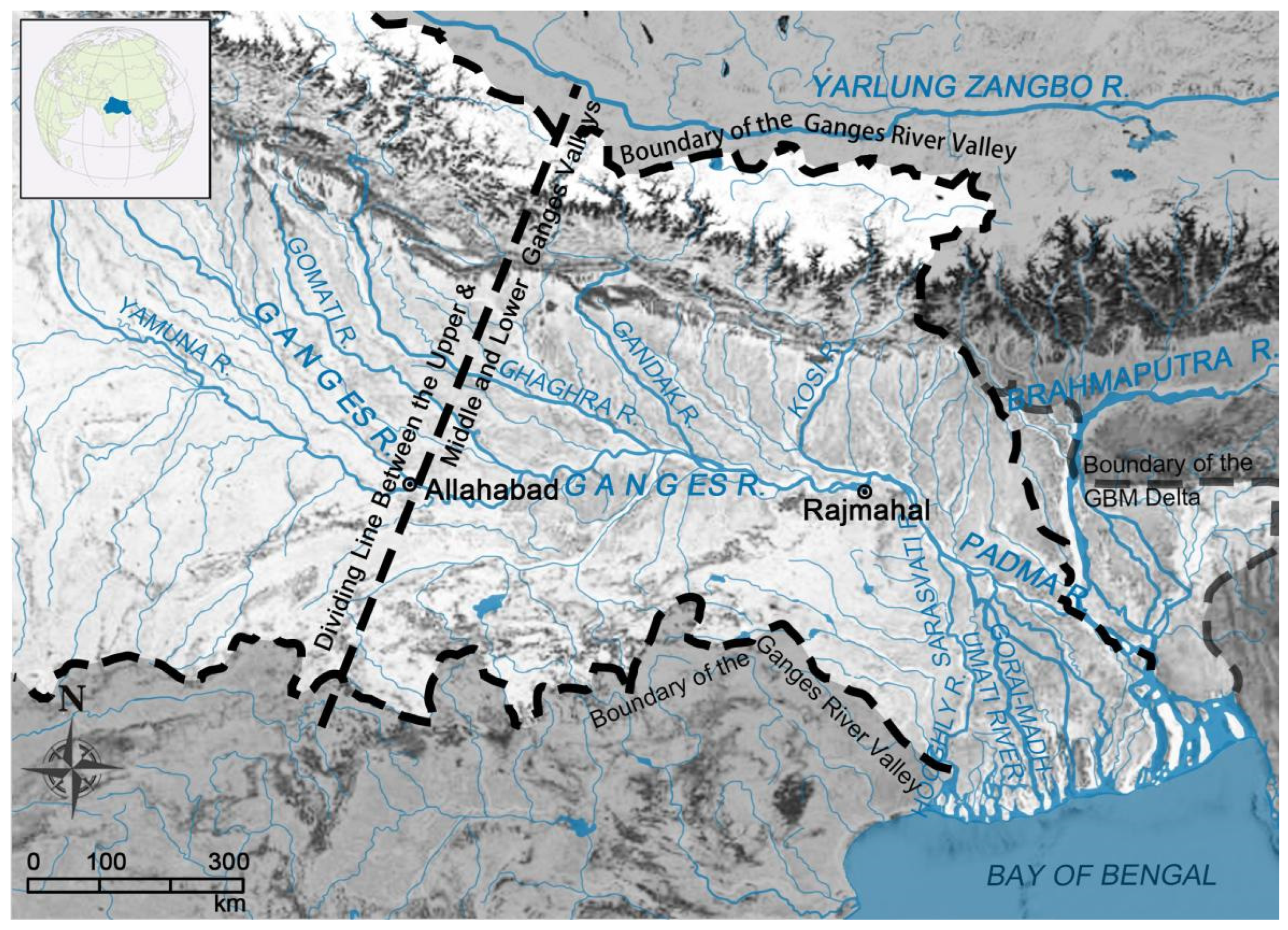
2.1. Geographical Environment

The geographical environment of the middle and lower Ganges Valley is the basic factor in the formation and evolution of regional city networks. The Ganges Valley is dominated by a terrain of plains, which gradually decrease in altitude from northwest to southeast (Figure 1). The geographical area between the Hooghly River and Meghna River is known as the Ganges Delta, and when combined with the delta of the lower Brahmaputra River and Meghna River, it is also called the Ganges–Brahmaputra–Meghna (GBM) Delta, which is included in the research area in this paper. Divided by the Gorai-Madhumati River, the Ganges Delta can be geologically divided into eastern and western parts. Traditional livelihoods and lifestyles based on rice agriculture, the demand for transportation, commerce and religious activities have caused the settlements of the Ganges Valley to be closely connected to rivers, although the problem of siltation caused by sedimentation has often led to the diversion of river channels in the lower Ganges throughout history [50]. However, while settlements located along the old river channel declined, settlements located along the new river channel were always able to develop rapidly [51].

2.2. Political System

The political system of the Muslim dynasties was the inner force that established the hierarchy of the city network. After the Delhi Sultanate instituted Muslim dynasties in 1206, the Mughal dynasty, emerging in the 16th century, united most of the South Asian subcontinent, reaching its peak in the mid-17th century and declining in the mid-to-late 18th century. Politically, the Indian Muslim dynasty established a developed system of administration, taxation and land tenure, strengthened the centralization of the regime, and instituted the absolute primacy of imperial capitals in the urban system by setting up three levels of administrative structures: provincial level (“Subah”), district level (“Sarkar”), and county level (“Pargana” or “Mahal”). Meanwhile, administrative centres at all levels constituted the basic city network hierarchy [52] (p. 205).

2.3. Industry and Commerce

Prosperous industrial and commercial trade constituted a strengthening factor for the development of city networks. On the one hand, the development of urban industry and commerce absorbed the resources of the surrounding hinterland, consolidating the scale of large towns and lifting their status. Since the Gupta dynasty, the land of the middle and lower Ganges Valley had been continuously reclaimed to the southeast by increasing populations [53] (pp. 45–47). In the middle of the 14th century, the agriculture of Bengal was developed as described in Wang Dayuan’s Daoyi Zhilue [54] (p. 803). According to the records of western travelers, many towns where textiles, sugar, metallurgy, paper and ships were manufactured flourished in the middle and lower Ganges, while raw materials and manufactured goods were exported and sold worldwide [55]. By the Mughal period, cities and towns had generally increased in size [56] (pp. 2–6). On the other hand, the influx of gold and silver from the East facilitated economic monetization in the middle and lower Ganges region, accelerating the frequency of land deals and the construction of new towns [56] (pp. 43–46), [57] (pp. 148–150).

2.4. Ideology and Culture

The spread and exchange of ideology and culture constituted a catalyst for the development of city networks. The fusion of Hinduism with Islam during the reign of the Muslim dynasty gave rise to a religious movement known as “Sufism”, whose leaders played a crucial role in promoting urbanization and leading the people to cultivate wastelands and exploit new settlements [58]. Meanwhile, the wide diffusion of Islam and Buddhism throughout Southeast and East Asia also promoted regional communication and created external links for city networks of the middle and lower Ganges Valley.

3. Materials and Methods

3.1. Analytical Methods

Against this historical background, to study the evolution mechanism of city networks, this paper adopts the perspective of the correlation between cultural routes and city networks. As networks, cultural routes connect cities and towns as nodes of the regional city system and are jointly affected by the driving forces of urban system development, and with the rise and fall of different cultural routes, the dynamic spatial pattern of the city networks has been shaped. Therefore, to analyze the driving forces and evolution mechanism behind the city networks, this research draws on the network theory and the centrifugal and centripetal force theory and applies them to the qualitative analysis of the evolution mechanism of the city networks, while the research on the spatial pattern of city networks is mainly based on the quantitative analysis of historical spatial data and supported by historical tax and population data. Two years with high spatial data resolution, 1605 and 1794, are selected, which can be generally used as the time slice of the beginning of the heyday and decline of the Mughal dynasty. The spatial structure of the city network in the two periods is compared through a GIS-based historical map translation method, and the evolution trend of the city network pattern in the middle and lower Ganges Valley from the 16th century to the mid-18th century is summarized.
In 1933, Colby proposed the theory of Centrifugal and Centripetal Forces in the study of urban spatial interaction, believing that these the two forces were the main forces driving the development of urban function, form and mode [59]. Krugman also used the two forces to describe the evolution of polycentric structures of economic relationships between firms and cities [12,60]. This theory has been related to competition and synergy in self-organizing theory. The centripetal force usually generates synergy and promotes urban spatial convergence, while centrifugal force usually produces competition and promotes urban spatial dispersion [61,62]. Therefore, the mechanism of the convergence and diffusion effect of the spatial structure of the city system under the action of driving forces formed by a variety of driving factors can be properly explained. To distinguish centrifugal from centripetal forces, Colby divides urban areas into three zones from the centre to the periphery, summarizing the six centrifugal and five centripetal forces that cause different functional movements between urban areas. This study draws on Colby’s theory and modifies its description of dynamic attributes to adapt to the description of the driving forces of city systems. According to Krugman’s hypothesis, a model that can explain the structure of polycentric cities must meet the following two criteria: centripetal and centrifugal forces must be equal, and the action range of centripetal force must be smaller than that of centrifugal force [60]. Therefore, for the city system in the middle and lower Ganges in the 16th to the mid-18th century with obvious heterogeneity, the zoning rule of Colby’s concentric circle model was not taken as the assumption, but Krugman’s polycentric network structure zoning was adopted. First, five driving factors of functional movement in urban systems are extracted from historical backgrounds, namely, geographical environment, political system, industry and commerce, and ideology and culture. Second, according to Colby’s dynamic attribute description, these five factors can all produce certain centripetal and centrifugal motions. To distinguish the dominant dynamic types at work, this study takes important historical events as the key indicators. Then, the dynamic attributes of these driving factors and their combination are associated with Colby’s dynamic attribute classification as the basis for determining the type of dominant driving forces (Table 1). Finally, the patterns of the overall and regional city network under influence are analyzed according to the strength and direction of the forces, thus clarifying the driving mechanism (Figure 2).

3.2. Materials and Technical Methods

After clarifying the driving mechanism of city network evolution, this paper analyzes the overall and regional spatial patterns of city networks based on the historical map translation method. This method was first developed by Cozen and used by many researchers [63] in urban morphological studies of a single historical town. This study provides a basis for using the GIS-based historical map translation method to study the spatial pattern of regional historic city networks. To some extent, it fills up the defects of insufficient spatial and temporal resolution in the previous study of historical urban systems. Technically, to achieve the goal, more accurate historical data are selected for spatial information reference, including the national statistical records and the first scientific surveyed maps of the entire Ganges Valley. The former document is the “Ain-i-Akbari” or the “Administration of Akbar” written by Emperor Akbar’s court historian, Abu’l-Fazl ibn Mubarak [64]; it contains statistics that include numbers, tax amounts and administrative hierarchies of towns in the middle and lower Ganges Valley. The latter is called A Map of the North Part of Hindostan produced under the leadership of James Rennell, the “Father of Indian Geography′′ and published in 1794 [65]; it contains spatial information such as the location of towns and forts, terrain and transportation routes. Contemporary historic atlases are also used as secondary sources, including An Atlas of Mughal Empire translated according to Ain-i-Akbari by Habib [36], A Historical Atlas of China edited by Tan [66] and A Historical Atlas of South Asia edited by Schwartzberg [52]. After spatial correction and georeferencing, the historical maps are translated and superimposed on contemporary satellite maps; at the same time, historical and spatial information extracted from maps of other sources, historical gazetteers and archaeological reports are also used for proofreading and complementation (Figure 3).
According to Habib, the numbers of places (mahals, mahal headquarters, and other places) within each sarkar shown in the Mughal atlas of 1605 were counted, and by measuring the area of the sarkar from the map, the average number of places per thousand square miles was calculated. This method is used for reference in this study. First, maps of the middle and lower Ganges Valley in 1605 and 1794 were superimposed after georeferencing in GIS, and the administrative boundary of 1605 was extracted and placed on the 1794 map to become the statistical boundary. Second, the geographical place density of each statistical boundary in 1794 was calculated in GIS. Due to the difference in the annotated level and total number of places in the two maps, to compare the density of places between 1605 and 1794, all the areas of the two maps, except those with no data or not counted (beyond the research area), are evenly divided into five levels: highest density area, high-density area, medium-density area, low-density area and lowest-density area. Therefore, the density changes of places in two different years in the middle and lower Ganges Valley can be compared intuitively.
The network structure does not mean the equal distribution of all nodes in space but emphasizes the complementarity of functions. In this study, the towns are basically divided into three grades: large, medium and small. The classification is based on historical maps and statistical data. First, officially surveyed historical maps not only record the geographical location of cities and towns as network nodes but also provide hierarchical information of these nodes from the perspective of administrative management. Usually, legends of different sizes are used to identify towns of different administrative levels. However, the administrative level is not completely equivalent to the town scale, so after the historical map translation, it is necessary to integrate the historical statistics, among which tax data of sarkars are also an important reference to grade the towns (Table A1). Therefore, some major towns in sarkars with lower administrative levels but more prominent economic levels have been upgraded. The 1601 Mughal statistics provide the area and taxes of the major sarkars (districts) without the exact area of the “Pargana” or “Mahal” (county or urban areas) in each sarkar, but we assume that the grade of major towns within a sarkar is proportional to the tax value per unit area of that sarkar. Thus, a sarkar whose tax per unit area is more than twice the provincial average will be considered to have the same grade as the provincial capital, and its grade can be upgraded from Level 2 to Level 1.

4. Results and Discussion

From the 16th to the mid-18th century, a combination of driving factors produced the opposite and unified forces, namely, centripetal forces and centrifugal forces, which drove the evolution of the city networks in the middle and lower Ganges Valley. The centripetal forces had a unified and integral effect on the city networks, while the centrifugal forces had an effect of dispersion and diversification on the city network; together, these forces fostered a systematic characteristic with overall stability and unity as well as dynamic local diversity, thus constituting a spatial pattern of a polycentric network based on cultural routes for which the Ganga River was the axis (Figure 4).

4.1. Analysis of the Forces and Mechanism Driving the Evolution of City Networks

The combination of systematic driving factors, such as the geographical environment, political system, industry and commerce, ideology and culture, generated centripetal and centrifugal forces of different natures that moved in different directions. The two types of forces clearly differentiated primary and secondary forces and fostered opposites to unite; together, they promoted the spatial evolution of city networks in the middle and lower Ganges Valley from the 16th to the mid-18th century.

4.1.1. Analysis of Centripetal Forces

The geographical environment in the middle and lower Ganges Valley and the political system of the Muslim dynasties came together as an axial centripetal force on the city networks through the development of transportation routes and the Mughal “poliscratic” form of government [67] (pp. 225–231).
On the one hand, land routes had long constituted a stable draw towards the cities and towns. Since the Mauryan dynasty, there has been an early land route known as the “Uttarapatha” (Northern Highway), which runs from east to the west across the Ganges Plains. Since Muslim rulers focused more on transportation for military and political purposes, the “Northern Highway” was expanded by Emperor Sher Shah to construct the “Grand Trunk Road” (Figure 5), which connected Lahore in the northwest and Sonargaon in the southeast. The highway was approximately 1500 kilometres long, with bridges built along the way and nearly 1800 “sarais” (post stations) equipped with hotels, wells, mosques and even markets; moreover, some of the “sarais” gradually grew into towns [68] (p. 7), [69]. On the other hand, the Ganges provided convenient water transportation, and the attractiveness of settlements changed dynamically with river navigability (Figure 6). In the mid-15th century, the Mahananda River, a western tributary of the lower Ganges, began to shift away from Pandua, the former capital of the Bengal Sultanate. The increasing flow of the Saraswati River in the south, which lies to the west of Gaur city, finally led to the relocation of the capital city to Gaur, along with the development of Saptagram as a major seaport downstream [70]. However, from 1535, the Saraswati gradually silted up and eventually diverted to the Hooghly River, and Gaur was abandoned due to a severe water shortage. Consequently, the port of Saptagram also declined and was replaced by the port of Hooghly downstream [71] (pp. 190–210). In contrast, Sonargaon port, on the eastern branch of the Ganges, had long thrived because it was surrounded by three rivers, one of which has increased in flow since the diversion of the Padma River.
In addition, based on the Mughals’ semi-nomadic lifestyle and their expansionist and centralized policy, a unique form of government was developed by Emperor Akbar, namely, “poliscracy”, which was a term stemming from the Greek word “polis” (town). Poliscracy meant consolidating the dynasty’s political position over the country’s vast and newly conquered hinterlands and controlling potentially rebellious enclaves by building a chain of towns, which also strengthened the centripetal force towards the city networks [67] (pp. 225–231). For instance, to mobilize the rich resources in the middle and eastern Ganges Valley for the northwest political centres, Agra and Delhi, Emperor Akbar first occupied the hinterland of the middle Ganga Plain while controlling Saptagram, Chittagong and the other main ports of the lower Ganges. To mobilize resources, many new towns along major transportation lines were then constructed, such as the new towns of Allahabad and Patna, as secondary centres for administrations, production and transit. Furthermore, he had political centres rotate between some of these towns to consolidate regional power [72] (pp. 27–30). Ultimately, this strategy generated a powerful centripetal force towards a chain of towns connecting the capital and the hinterland to secondary administrative centres and centres of production and transit, as well as to trading ports along the main transportation lines.

4.1.2. Analysis of Centrifugal Forces

The combination of industry and commerce with ideological and cultural factors not only produced a certain centripetal force but also an obvious centrifugal force that operated in different directions with different intensities and influenced the evolution of city networks through external exchanges and grassroots social organizations.
The centrifugal force generated by maritime trade that operated on the city networks went in two directions: east and west. After the decline of Arabian maritime power, the European traders came to Asia in the late 15th century, but their commercial activities were limited to small trading stations along coastal and river ports until the mid-18th century [73] (pp. 28–35). Meanwhile, the vast areas of South and Southeast Asia were all included in China’s massive tributary trading network, and numerous ports of these areas were connected with the lower Ganges Valley through the ports of Chittagong and Sonargaon [71] (pp. 28–34), [53] (p. 907). In the 15th century, the commercial fleet of the Ming dynasty visited the Bengal Sultanate four times, while the Bengal Sultanate paid tribute to the Ming dynasty fourteen times. The economic exchange between the two continued until the British took over Bengal [74] (p. 131). By comparison, by the mid-18th century, the scale of western maritime trade was far less than that of eastern trade [57], so the centrifugal force of maritime trade exerted more influence eastwards on city networks in the middle and lower Ganges Valley than westwards.
The centrifugal force generated by land trade acted on city networks from several directions (Figure 7). First, the westward trade within the Ganges Valley was unstable for a long time during the Middle Ages due to the wars occurring in the northwest part of the South Asian subcontinent. In the 14th century, the Mongol Empire had even blocked the land routes to Central Asia, which greatly weakened the impact of the centrifugal force generated by westwards trade. Second, the centrifugal force generated by southwards trade was limited in its intensity and continuity by the political North–South division of the subcontinent. In contrast, the eastern and northern centrifugal forces generated by land trade were relatively stable over time. Since China’s Tang and Song dynasties, the northern centrifugal force was generated by the tea-horse trade that flourished among the areas of Bengal, Assam, Nepal, Bhutan and Tibet [75]. Although goods were mainly transported by horse caravans in the Himalayan Mountains and the scale of the trade was far smaller than that in the maritime regions and plains, it remained stable for a long time because of the high margins and constant necessity of commodities. It was inferred that except for the route going from Allahabad in the middle Ganges to Tibet via Nepal [31] (p. 64) (Table 2), there were another three common trade routes going from the lower Ganges Valley to Assam via Gaur (Table 3). The main routes from Assam to Tibet went from Sikkim and Bhutan to Lhasa [76] (Table 4).
The eastern centrifugal force had a longer history and mainly developed out of the land trade routes connecting the middle and lower Ganges Valley to Myanmar and China’s Yunnan Province (Figure 8). These routes entailed three common trade routes and a folk passage. The first route was the “Shu-Yuandu Pass” recorded in Xin Tangshu, which ran from Dali in Yunnan to Bhamo, Myitkyina and Mogaung and then along the Patkai-Hukong Valley to “Daqin Poluomen” (Manipur) and Guwahati in Assam [54] (pp. 647–648). The second and third routes were presumed to be waterways going from Sibsagar in Assam along the Chindwin and Manipur Rivers to Myanmar and the land route going from the Bengal Delta along the coastline to the Arakan region (today’s Rakhine State in Myanmar) [31] (p. 20), [40,77] (pp. 74–75). The fourth route was a folk passage recorded in Manshu; it went from Sadiya to Zayul over the “Great Snowy Mountain” along the Meikaien River to Putao and passed through Myitkyina to Tengchong in Yunnan [78] (pp. 37–40). During the Yuan and Ming dynasties, a large number of post stations, post roads and caravan roads connecting Yunnan to Tibet were built, creating a closer relationship among historical China, Myanmar and India [79]. In the 13th century, a branch of the royal family of the Yunnan Tai people entered the eastern Brahmaputra Valley and established the Ahom (Assam) Kingdom. They built roads and towns and competed with the Mughals over the control of the Assam region, through which Tibetan trade had to pass [80]. In the mid-16th century, the Koch Kingdom, a tribal state of the Assam Kingdom, built the 560 kilometre-long “Gohain Kamal Ali” road, which connected Narayanpur in the east and Kamatapur in the west of Assam [81] (p. 208), enhancing the north-eastern centrifugal force.
The catalytic effect of ideology and culture was realized through the organization of religious activities and grassroots autonomy, generating centripetal and centrifugal forces operating in different directions with various degrees in different subregions of the city network. Since the middle Ganga Plain and the western GBM Delta were areas with deep Hindu traditions, constant pilgrimages in the areas not only expanded the scale of the large towns as prominent ritual centres but also promoted the development of small and medium towns along the pilgrimage paths, thus strengthening the axial centripetal force of transportation routes. However, in the eastern GBM Delta, where a complex river system and dense forest existed, the lack of prominent political, economic and cultural centres in the long term led to a later start of the urbanization process. After the 13th century, the arrival of Muslim armies and settlers from the west promoted the wide and rapid spread of Islam in the eastern part of the Delta. Mosques proliferated [82] (p. 8), often located near the houses of landlords (“Zamindars”) or religious leaders at the river trading nodes, forming many small and scattered communities around them [58]. Aside from being ritual centres, these mosques also served as autonomous institutions and trade transit stations [83] (p. 395–413), and they generated relatively homogeneous and dispersed weak centrifugal forces operating on the basis of the city network system as it was already evolving. Since the main tributaries of the lower Ganges were diverted eastwards into the Padma River, some communities in the eastern delta flourished and developed into transitional towns or ports; for example, the old transit station Chittagong became a major port for Indo-Southeast Asian-China trade in the Bay of Bengal in the 16th century [84] (pp. 98–127).

4.2. Analysis of Spatial Pattern Formed by the Evolution of City Networks

4.2.1. Polycentric Axis Network: Overall Pattern of City Networks in the Middle and Lower Ganges Valley

From the 16th century to the mid-18th century, the spatial pattern of city networks in the middle and lower Ganges Valley was developing towards a polycentric pattern and showed a trend of eastwards expansion. By the time of the Mauryan dynasty, the urban axis developing around the Ganga River had taken shape; its structural centre was located in the middle Ganga Plain, where there were many large cities and towns [39] (p. 109), [85]. However, influenced by the decline of Roman trade and the wars between great powers in the northwest of the Indian subcontinent during the Middle Ages, the middle Ganga Plain experienced a large-scale urban decay [86], while the towns of the western GBM Delta continued to develop because of their continuous trading with Southeast Asia and East Asia [87]. This context made the centre of the urban axis shift towards the western GBM Delta. From the 16th century to the mid-18th century, the town networks of the middle and lower Ganges Valley expanded significantly towards the eastern delta, showing a polycentric development trend that placed large urban centres evenly in the middle Ganga Plain and the eastern and western delta. Evidence can be provided on two bases. First, according to Habib’s statistical analysis of the Ain-i-Akbari (1605), if the density of places were calculated at the district level, the Varanasi district in the middle Ganga Valley and the Malda district with the old Bengal capitals Gaur and Pandua as the centre in the northwestern GBM Delta had become the two districts with the highest density [36] (pp. x–xvii) (Figure 9). Second, if the tax amount of towns at the district level was calculated and ranked into four levels according to each town’s tax per unit area (the towns included in the first level generated the most taxes), there were as many first-level towns in the Patna District of the middle Ganga Plain as in Bengal of the lower Ganges. After calculating the toponymic density distribution on the 1794 map of the Ganges valley, the areas with the highest density largely shifted from the middle Ganga Plains to the north and west of the GBM Delta, forming a belt-like area with the highest density connecting the north and south of the Delta, and the toponymic density in the eastern Delta also demonstrated a general increase (Figure 10). According to travel notes by Brito, between 1520 and 1530, Gaur, the old Bengal capital in the northern Delta, became a high-density city covering 80 square miles and boasting a population of between 100,000 and 200,000 [88].
The secondary and tertiary towns in the city network, namely, medium-sized towns, served as connectors between large towns and the rural hinterland in the middle and lower Ganges Valley, and most of them had administrative, fiscal or productive functions. These medium-sized towns were mostly located at the junction of the tributaries of the Ganga and the branch lines of land routes, forming a derrick-shaped medium town belt around the main axis (Figure 11). Before the Muslim dynasties, the distribution of the middle-level towns were limited to the middle Ganga Plain and the western delta, while there were only very few towns in the eastern delta. It was in the 16th century that the number and size of towns in the eastern delta increased significantly, catalyzed by a series of physical, geographical, political and military events, including the Ganges diversion, the construction of the Grand Trunk Road and the establishment of the provincial capital of the Mughal Bengal in Dacca (Dhaka) [89] (pp. 41, 47). The toponymy statistics of 1605 show that the total number of towns ranked above the third level in Bengal Province surpassed that of the middle Ganga Plain; moreover, along the diverted Padma River, a belt of high-density area developed, spreading from the south-eastern GBM Delta to the coast of Chittagong [36] (pp. x-xvii). As recorded by the Portuguese preacher Fray Sebastien Manrique, the population of Dacca city, the new centre of the eastern town network, also exceeded 200,000 in 1640 [90] (pp. 118–120).

4.2.2. Diverse Secondary Networks: Subregional Patterns of City Networks in the Middle and Lower Ganges Valley

As early as 800 BC to approximately 600 BC, the Ganges River Valley had already included several ancient countries developed from different cultural divisions bounded by mountains and rivers, and the earliest subregional city networks gradually developed around their capitals. Influenced by different driving factors to varying degrees, four subregional city networks with distinctive spatial patterns were formed by the mid-18th century (Figure 12).
The subregional city network in the middle Ganga plain demonstrated a pyramidal pattern dominated by political system. Before the Muslim rulers moved their capital to Delhi, the middle Ganga Plain had been the political core of the great powers of Northern India throughout history, including the Mauryan dynasty and the Gupta dynasty. This region had been under the direct control of the central government, so its city network demonstrated an obvious feudal hierarchical character. In Arthasastra, Kautilya described an ideal pyramidal settlement model of a city state with one central and first-level city, two secondary-level towns, four third-level towns and eight fourth-level towns, all located at the centre of the lower-level town clusters; and at the lowest level of this model, there were 800 villages with fourth-level towns as their centres [89] (pp. 99–102) (Figure 13). From the 16th century to the mid-18th century, the middle Ganga Plain presented a pyramidal spatial pattern in which the rank of towns decreased gradually when moving from the Ganges axis to the agricultural hinterland. This model was further enhanced by commercial and industrial prosperity during the Mughal period. Not only did the first-level towns at the top of the pyramid, such as Patna, Varanasi and provincial towns, become more prominent, but the number of small and medium-sized towns at the lower levels of the pyramid also increased significantly.
The subregional city network in the western GBM Delta formed a belt pattern dominated by industry and commerce. Throughout history, the Ganges-Brahmaputra, which is bordered by the Chota Nagpur Plateau in the west and the Bay of Bengal in the south, had always been on the edge of the great powers of northern India. It had also long been relatively independently ruled by local states whose urban system had no obvious pyramidal model. In this region, ports can easily be connected to agricultural hinterlands via the Ganges, and archaeological data indicate that the evolution of towns was significantly driven by overseas trade [91]. From the 16th century to the mid-18th century, the development of manufacturing industries and interregional and international trade endowed the river towns along the Ganges with a more compound function, and the number and size of these towns significantly increased. For example, along the western tributaries of the lower Ganges, Murshidabad, Saptagram, and Hooghly constituted a series of towns that were both manufacturing and trading hubs, and these towns eventually evolved to form a stretching urban belt with large river port cities as its core (Figure 14).
The subregional city network in the eastern GBM Delta formed a decentralized pattern dominated by sociocultural factors. The eastern GBM Delta, which is linked to the Assam and Arakan areas, is characterized by a decentralized city network dominated by sociocultural factors. Due to the dominant terrain of flat and homogeneous alluvial plains with few specific natural geographical nodes in this area and the fact that production centres were long controlled by semiautonomous landowners such as the Brahmin nobility (Zamindars) or the Sufi leaders [92] (p. 41), there was a lack of strong centripetal forces influencing the evolution of the city network. As a result, the landscape developed into mostly a rural area dotted with small market towns along the rivers. The basic social organization unit in this area was a “samaj”, namely, a family of the same caste or a group of people following the same religious leader; their houses usually formed a loose “mulla” (community) around a mosque in this landscape, and the physical space occupied by the community showed no distinct shape or boundaries [93] (pp. 580, 590) (Figure 15). Similar grassroots autonomous organizations existed widely in the south-eastern part of the GBM Delta, and to a certain extent spread to the central and northern parts of the delta. Sociologists have described that, in the Rajshahi district, approximately 50 to 60 such “mullas” (communities) composed one “jamaat”, whose size was close to that of a normal village in northern India [94] (pp. 11–14). It was not until the mid-16th century that river ports or market centres such as Dacca, Sonargaon or Chittagong developed into larger towns, but their numbers were very limited until the mid-18th century.
The subregional city network in the northern GBM Delta formed a hub pattern dominated by regional transportation. Connecting the Ganges Valley in the west and the Brahmaputra Valley in the east, the northern GBM Delta leads to Bhutan, Nepal and Tibet in the north and reaches the Bay of Bengal in the south; therefore, the development of the city network in this subregion benefited greatly from the location and transportation advantage. Historically, since northbound trade was mostly carried out during the dry seasons and entailed a constant transmission of goods along fixed routes, large commercial or distribution centres tended to develop at transport hubs (Figure 16). Among the six medieval capitals of Northern India from the 8th to the 16th centuries, the four cities with larger palaces were located at the intersection of land and water transportation routes in the northern delta. From the 16th century to the mid-18th century, the transportation network between this region and the Yunnan and Tibet regions of China was expanded and strengthened so that a series of large border towns developed out of trade and distribution centres or transport hubs, such as Dinajpur, Rangpur and Cooch Behar, which had become important commercial centres on the trade routes through the northern border of the Delta.

4.3. The Functional Structure of the City Network

The city network theory places more emphasis on functional interactions between cities and towns, rather than the sizes and hierarchies of cities and towns [95]. Although many towns in the region at the time were known for producing goods such as textiles or boats, the economy had not yet developed a highly specialized division of labour, and the functions of individual cities were often composite. However, the combination of several towns with similar functions and emphases will form regional clusters with specific functions, which will generate certain functional complementarity and form a macroscopic functional structure. The functional structure of Mughal “poliscracy” was actually a series of functional complementary town clusters around the axis of the Ganges: in the upper Ganges Valley, there were political clusters centred around national capitals such as Delhi and Agra; in the middle plains, there were administrative and manufacturing clusters centred around large provincial capitals such as Allahabad, Varanasi and Patna; in the lower Ganges Valley, there were import and export trade clusters centred around ports such as Saptagram, Kolkata Dacca and Chitagong; and the northern part of the GBM Delta are trade and distribution clusters centred around transportation hubs such as Rangpur and Cooch Behar. Meanwhile, in each regional cluster, there was a certain cooperation and functional complementarity, forming a microscopic functional structure. In the middle of the Ganges, large cities such as Allahabad, Varanasi and Patna along the Ganges formed major manufacturing centres, and peripheral secondary towns such as Sasaram, Munger, and Hajipur were transit and administrative centres connecting large cities and agricultural hinterlands. In the Western GBM Delta, the first-level city of Burdwan, between the Chotanagpur Plateau and the Bay of Bengal, served as both a transport hub for mountain products and a transit hub for imports and exports. In the Western GBM Delta, the function of old political and religious centres such as Gaur and Pandua upstream depended on manufacturing towns such as Murshidabad and ports such as Saptagram downstream. Large distribution centres such as Rangpur in the Northern Delta and secondary border towns formed the relationship between the regional headquarters and distribution centres of the tea-horse trade. Large port cities such as Dacca in the Eastern GBM Delta served as distribution headquarters for numerous small market towns in the surrounding river trade area, as well as major transit points from a series of smaller ports such as Chittagong on the east coast of the Bay of Bengal.

4.4. Discussion

According to the former analyses, for the city networks in the middle and lower Ganges from the 16th to the mid-18th century, the combination of different driving factors formed the centripetal force with the axis of the Ganga River and the centrifugal force with different strengths and directions. The two driving forces balanced each other and contributed to an open and dynamic system with overall unity and local diversity. Among all the driving factors, the direct factor was dominated by two key indicators: the eastwards expansion of land transportation and the diversion of major tributaries of the Ganges. The internal factor was also dominated by two key indicators: the administrative structure and “poliscratic” ruling strategy of the Mughal dynasty. The two driving factors together constitute the main centripetal force shaping the axial spatial pattern of the entire city networks. At the same time, the external factor and catalytic effect brought by international and regional economic, ideological and cultural exchanges, especially with Southeast Asia, Tibet and Yunnan in China, constitute the main centrifugal forces leading to the structural differentiation, and eastwards and northwards expansion of the network. Finally, a polycentric axis city network was formed in the middle and lower Ganges Valley, which became the basis of the modern urban system in this region.
In the past, influenced by Western documents of the Middle Ages, modern colonial economic theory and the linear mode of urban development, the mainstream view in the field of urban history recognized medieval India’s urbanization as mainly a political process. In addition to the imperial capital cities and the provincial administrative towns, the urbanization level was considered generally low, and there was an obvious cultural gap between rural and urban areas [28]. However, in recent years, with the increased interpretations of Persian documents, East India Company archives and other historical materials, some researchers have tried to shed light on the prosperity of medieval towns of South Asia from the perspective of commerce and trade, but few of them have tried to put the research foothold back to the communication within Asia. The special feature of this study is the introduction of a cultural route perspective, which places the evolution of the urban system in the middle and lower Ganges Valley within the evolution process of the larger Asian economic and cultural networks. Based on the network theory and the centrifugal and centripetal force theory, this study reveals an open and dynamic evolution model of a networked urban system in which various driving factors, besides the political factors, all play a pivotal role. Under the joint action of centripetal and centrifugal forces formed by these factors, the final evolution result is not a fixed urban—rural dual structure but a nonlinear self-organizing polycentric axis network structure. This structure has strong vitality in multicultural areas.
Currently, researchers are promoting the research of spatial interacting and urban dynamics models in exploring the temporal dimension of self-organizing systems and pursuing better visualization effects to assist decision-making in planning. The limitation of this research is that within the limited content of the article, it only builds up a theoretical framework explaining the evolutionary mechanism of historic city networks for qualitative analysis, and there is no quantitative network analysis based on GIS to verify whether the spatial patterns of city networks are consistent with the qualitative analysis results. Moreover, currently the research team has not yet found enough data to support a standard model of historical city networks in the research area during this historical period. Theoretically speaking, as long as the spatial and temporal resolution of the collected historical data is high enough, one may reproduce the evolution process of the urban system in a certain historical stage by building microscopic urban dynamic models, for example, a cellular automata (CA) model [96] and verify the prediction results of the model with the historical facts of the later historical stage to test whether the model is reliable. Therefore, as more historical documents containing reliable spatial data are discovered and utilized in the future, an analytical model that can be applied to the historical urban system may be developed and hopefully be improved in more similar studies.

5. Conclusions

This study introduces the historical perspective and cultural dimension into city network theory by studying the historical urban system based on the concept of cultural route and constructs a set of analysis frameworks of urban spatial evolution mechanisms based on the centrifugal and centripetal force theory and network theory. It also explores the application of GIS-based historical map translation methods in the reproduction of historic city network spatial evolution in multicultural regions. The results show that from the 16th century to the mid-18th century, physical geography and political factors together constituted the main centripetal forces shaping the overall pattern of the city network, while economic, ideological and cultural factors formed the main centrifugal forces leading to the differentiation of subregional structures. Under the joint action of these two countervailing forces, the urban system of the middle and lower Ganges Valley formed an overall unified and locally diverse polycentric axis network structure. It can be concluded that the fundamental reason for the formation of different spatial patterns of regional historical city networks in the context of multiculturalism lies in the interconnection modes and intensities between towns under the action of different driving forces. Therefore, in regard to decision making in urban system planning and heritage conservation, historic towns should not be treated in isolation but should be placed in broader contexts and multidimensional networks. Currently, several regional cooperation initiatives deriving from cultural routes, such as the “China-Bangladesh-India-Myanmar Economic Corridor” and the “South Asia Corridor” initiated by China and the “Project Mausam” initiated by India, have been rebuilding the historical ties that existed within the past Asian city networks. It is of great significance to identify the contemporary value of shared cultural heritage in Asia and promote the circulation of regional historical and cultural resources, thus exploring the Asian mode of urban system planning and sustainable development. On this basis, research on networks of Asian historic towns should continue to be carried out from open and diverse perspectives.

Author Contributions

Conceptualization, X.W.; methodology, X.W. and W.D.; software, X.W.; validation, X.W.; formal analysis, X.W.; investigation, X.W.; resources, X.W. and W.D.; data curation, X.W.; writing—original draft preparation, X.W.; writing—review and editing, X.W.; visualization, X.W.; supervision, W.D.; project administration, W.D.; funding acquisition, W.D. and X.W. All authors have read and agreed to the published version of the manuscript.

Funding

This research was funded by the National Natural Science Foundation of China, grant number 51978145 and Scientific Research Fund of Zhejiang University City College, grant number J-202219.

Institutional Review Board Statement

Not applicable.

Informed Consent Statement

Not applicable.

Data Availability Statement

Not applicable.

Acknowledgments

Appreciation should be shown to the China Scholarship Council, who supported my one-year visit in EFEO (École française d’Extrême-Orient) Paris, while the library of EFEO Paris (Bibliothèque de l’EFEO Paris) and the library of INALCO (Institut National des Langues et Civilisations Orientales) allowed my access to various useful historical documents. Special thanks should be given to Wang Yongping of Nanjing Tech University, who led our survey of cities and towns in South Asia several times.

Conflicts of Interest

The authors declare no conflict of interest.

Appendix A

Table A1. Area and Jama (Revenue) of the Mughal Empire, c.1601. Source: This table is reused directly from Reference No. [36], (p.vii). https://en.banglapedia.org/index.php/Sarkar (accessed on 1 November 2022).
Name of Province and SarkarArea (Square Miles)Tax Unit Jama (Dams) *Tax Per Square Mile
BENGAL71,160254,370,5623574.62847
Tanda/Udambar (Rajmahal, Murshidabad and North Birbhum)351124,078,700.56858.07477
Guar/Lukhnauti (mainly Malda)177218,846,97610,635.991
Fatehabad (Faridpur, South Bakarganj)30637,969,5682601.88312
Mahmudabad (North Nadia, North Jessore and West Faridpur)511011,610,2562272.06575
Khalifatabad (South Jessore and West Bakarganj)51575,402,1401047.53539
Bakla (North and West Bakarganj and South-west Dhaka)20207,131,6413530.51535
Purnea 21826,408,7932937.1187
Tajpur (West Dinajpur)22096,483,8572935.20009
Ghoraghat (South Rangpur, South-East Dinajpur and North Bogra)37618,983,072.52388.47979
Panjra/Pinjarah (Dinajpur, part of Rangpur and Rajshahi)18615,803,2753118.36378
Barbakabad (mainly Rajshahi, South-west Bogra and South-east Malda)287817,451,5326063.77067
Bazuha (Partly Rajshahi, Bogra, Pabna and Dhaka)854839,516,8714622.93765
Sonargaon (West Tripura and Noakhali)397510,331,3332599.07748
Silhat/Sylhet (Srihatta)54886,681,3081217.4395
Chatgaon/Chittagong248311,424,3104601.01087
Sharifabad (Mostly Burdwan)210522,488,75010,683.4917
Sulaimanabad (North Hooghli, part of Nadia and East Burdwan)238817,629,9647382.73199
Satgaon/Saptgram (24 Parganas, West Nadia and Hawrah)560016,724,8242986.57571
Madaran (Bankura, Vishnupur, South-east Burdwan)70499,403,4001334.00482
BIHAR55,478221,848,096.54000.13346
Bihar17,20483,196,3904835.8748
Monghyr774529,625,981.53825.17515
Champaran33765,513,4201633.12204
Hajipur (Patna)247927,331,03011,025.0222
Saran402816,172,004.54014.89685
Tirhut650919,189,777.52948.19135
Rohtas (Sasaram)646640,819,4936312.94355
Khokhra7671-
ALLAHABAD34,613212,427,565
212,427,819
6137.22645
Allahabad258722,831,9998825.66641
Ghazipur147513,431,3259105.98305
Banaras5878,860,31815,094.2385
Jaunpur616456,394,9279144.21269
Manikpur260033,916,52713,044.8181
Chunar15615,810,6043722.36003
Bartha Gahora10,7817,262,780637.664781
Kalinjar593723,839,4704015.40677
Korra133317,397,56713,051.4381
Kara158822,682,04814,283.4055
AWADH26,463201,364,2037609.27344
Awadh (Ayhodya/Faizabad)306340,956,34713,371.318
Gorakhpur855211,926,7901394.61997
Bahraich413724,120,5255830.43872
Khairabad482843,644,3819039.84693
Lucknow588380,716,16013,720.238
* The statistical unit of Jama is denoted by dams (copper coins). At the time of Ain-i-Akbari, one rupee was convertible into 40 dams.

References

  1. ICMOS. The ICOMOS Charter on Cultural Routes. 2008. Available online: https://www.icomos.org/images/DOCUMENTS/Charters/culturalroutes_e.pdf (accessed on 1 November 2022).
  2. Duara, P. The Crisis of Global Modernity; Cambridge University Press: Cambridge, UK, 2015. [Google Scholar] [CrossRef]
  3. Batty, M. Urban Modelling; Cambridge University Press: Cambridge, UK, 1976; Available online: http://www.casa.ucl.ac.uk/rits/batty-urban-modelling-2009.pdf (accessed on 1 November 2022).
  4. Getis, A.; Getis, J. Christaller’s Central Place Theory. J. Geogr. 1966, 65, 220–226. [Google Scholar] [CrossRef]
  5. Jefferson, M. Why Geography? The Law of the Primate City. Geogr. Rev. 1989, 79, 226–232. [Google Scholar] [CrossRef]
  6. Gabaix, X. Zipf’s Law for Cities: An Explanation. Q. J. Econ. 1999, 114, 739–767. [Google Scholar] [CrossRef] [Green Version]
  7. Jacobs, J. The Death and Life of Great American Cities; Random House: New York, NY, USA, 1961. [Google Scholar]
  8. Miller, J.H.; Page, S.E. Complex Adaptive Systems: An Introduction to Computational Models of Social Life; Princeton University Press: Princeton, NJ, USA, 2007. [Google Scholar]
  9. Bettencourt, L.; West, G. A unified theory of urban living. Nature 2010, 467, 912–913. [Google Scholar] [CrossRef]
  10. Forrester, J.W. Urban Dynamics; MIT Press: Cambridge, UK, 1969. [Google Scholar]
  11. Bourne, L.S.; Simmons, J.W. Systems of Cities; Oxford University Press: New York, NY, USA, 1978. [Google Scholar]
  12. Krugman, P. The Self-Organizing Economy; Blackwell Publishers: Cambridge, UK, 1996. [Google Scholar]
  13. Coffey, W.J. Urban systems research: An overview. Can. J. Reg. Sci. 1998, 21, 327–364. Available online: https://idjs.ca/images/rcsr/archives/V21N3-Coffey.pdf (accessed on 1 November 2020).
  14. Portugali, J. Self-Organization and the City; Springer Science & Business Media: Berlin, Germany, 1999. [Google Scholar]
  15. Allen, P.M. Self-organization and evolution in urban systems. In Cities and Regions as Nonlinear Decision Systems; Crosby, R.W., Ed.; Routledge: London, UK; New York, NY, USA, 2019; pp. 29–62. Available online: https://books.google.com/books?hl=zh-CN&lr=&id=u8PADwAAQBAJ&oi=fnd&pg=PP1&dq=Cities+and+Regions+as+Nonlinear+Decision+Systems&ots=-QEtMlHbq3&sig=VFvDRratbZegGC4WqU26KbuAtdQ#v=onepage&q=Cities%20and%20Regions%20as%20Nonlinear%20Decision%20Systems&f=false (accessed on 1 November 2020).
  16. Wilson, A.G. A family of spatial interaction models, and associated developments. Environment and Planning A 1971, 3, 1–32. [Google Scholar] [CrossRef] [Green Version]
  17. Allen, P.M.; Sanglier, M. Dynamic models of urban growth. J. Soc. Biol. Struct. 1978, 1, 265–280. [Google Scholar] [CrossRef]
  18. Wilson, A. Entropy in urban and regional modelling. In Handbook on Entropy, Complexity and Spatial Dynamics; Reggiani, A., Ed.; Edward Elgar Publishing: Cheltenham, UK, 2021; pp. 20–31. [Google Scholar] [CrossRef]
  19. Wegener, M. Operational urban models state of the art. J. Am. Plan. Assoc. 1994, 60, 17–29. [Google Scholar] [CrossRef]
  20. Friedmann, J.; Wolff, G. World City Formation: An Agenda for Research and Action. Int. J. Urban Reg. Res. 1982, 6, 309–344. [Google Scholar] [CrossRef]
  21. Friedmann, J. The world city hypothesis. In World Cities in A World System; Knox, P.L., Taylor, P.J., Eds.; Cambridge University Press: Cambridge, UK, 1995; pp. 317–331. [Google Scholar]
  22. Castells, M. The Rise of the Network Society; Blackwell Publishing Ltd.: Hoboken, NJ, USA, 1996. [Google Scholar] [CrossRef]
  23. Camagni, R.; Capello, R. The City Network Paradigm: Theory and Empirical Evidence. Contrib. Econ. Anal. 2004, 266, 495–529. [Google Scholar] [CrossRef]
  24. Malecki, E.J. Entrepreneurs, Networks, and Economic Development: A Review of Recent Research. In Reflections and Extensions on Key Papers of the First Twenty-Five Years of Advances; Katz, J.A., Corbett, A.C., Eds.; Emerald Publishing Limited: Bingley, UK, 2018; Volume 20, pp. 71–116. [Google Scholar] [CrossRef]
  25. Wang, C.; Chen, L. Study on Urban Agglomeration Layout From the Network-City Perspective: A Case Study of Suzhou-Wuxi-Changzhou Urban Agglomeration. Resour. Environ. Yangtze Basin 2006, 15, 797–801. (In Chinese) [Google Scholar]
  26. Zhang, F.; Ning, Y.M. The Autonomous Construction of Urban Network Research in China. Reg. Econ. Rev. 2020, 2, 84–92. (In Chinese) [Google Scholar] [CrossRef]
  27. Spodek, H. Studying the History of Urbanization in India. J. Urban Hist. 1980, 6, 251–295. [Google Scholar] [CrossRef]
  28. Ramachandran, R. Urbanization and Urban Systems in India; Oxford University Press: Delhi, India, 1989. [Google Scholar]
  29. Thakur, S.K. Recent Studies in Regional Urban Systems in India: Trends, Patterns and Implications. In Spatial Diversity and Dynamics in Resources and Urban Development; Springer: Dordrecht, The Netherlands, 2016; pp. 39–65. [Google Scholar] [CrossRef]
  30. Chakrabarti, D.K.; Rakshit, M. The Archaeology of Ancient Indian Cities; Oxford University Press: Delhi, India, 1995. [Google Scholar]
  31. Chakrabarti, D.K. Archaeological Geography of the Ganga Plain: The Lower and the Middle Ganga; Permanent Black: Delhi, India, 2001. [Google Scholar]
  32. Lal, M. Settlement History and Rise of Civilization in Ganga-Yamuna Doab, From 1500 BC to 300 AD; BR Publishing Corporation: Delhi, India, 1984. [Google Scholar]
  33. Erdosy, G. Urbanisation and the Evolution of Complex Societies in the Early Historic Ganges Valley. Ph.D. Dissertation, University of Cambridge, Cambridge, UK, 1985. [Google Scholar]
  34. Allchin, F.R.; Erdosy, G. The Archaeology of Early Historic South Asia: The Emergence of Cities and States; Cambridge University Press: Cambridge, UK, 1995. [Google Scholar]
  35. Raza, M.; Habeeb, A. Characteristics of Colonial Urbanization: A Case Study of Satellite Primacy of Calcutta (1850–1921). In A Reader in Urban Sociology; Rao, M.S.A., Bhat, C., Kadekar, L.N., Eds.; Orient Longman: Hyderabad, India, 1991; pp. 49–69. Available online: https://books.google.com/books?hl=zh-CN&lr=&id=fEwOQh41NZMC&oi=fnd&pg=PA49&dq=Raza,+M.++Characteristics+of+Colonial+Urbanization:+A+Case+Study+of+Satellite+Primacy+of+Calcutta&ots=at3V3ZeLfh&sig=YpL8XGQB-YY_o4Z-fuu8iwQQcGk#v=onepage&q&f=false (accessed on 1 November 2022).
  36. Habib, I. An Atlas of Mughal Empire; Oxford University Press: New Delhi, India, 1982; Available online: https://archive.org/details/Book_1109/page/n5/mode/2up (accessed on 1 November 2022).
  37. Moosvi, S. The Economy of the Mughal Empire c. 1595, A Statistical Study; Oxford University Press: New Delhi, India, 2015. [Google Scholar]
  38. Chandra, M. Trade and Trade Routes in Ancient India; Abhinav Publications: New Delhi, India, 1977. [Google Scholar]
  39. Lahiri, N. The Archaeology of Indian Trade Routes: Up to c. 200 BC; Oxford University Press: Delhi, India, 1992. [Google Scholar]
  40. Ray, H. The Southern Silk Route From China to India—An Approach From India. China Rep. 1995, 31, 177–196. [Google Scholar] [CrossRef]
  41. Chakrabarti, D.K. The Ancient Routes of The Deccan and the Southern Peninsula; Aryan Books International: New Delhi, India, 2010. [Google Scholar]
  42. Lin, C.M. A Preliminary Research of the Sichuan-India Route. In Collection of Southwest Ethnic History Research, Volume 2; Institute of History of Southwest Frontier Nationalities, Yunnan University: Kunming, China, 1981. (In Chinese) [Google Scholar]
  43. Lan, Y. The Southern Silk Route; Chongqing University Press: Chongqing, China, 1992. (In Chinese) [Google Scholar]
  44. Fang, G.Y. An Interpretation of the Historical Geography of Southwest China; Zhong Hua Book Company: Beijing, China, 1987. (In Chinese) [Google Scholar]
  45. Duan, Y. The Southern Silk Route: China-India transportation and cultural corridors. Thinking 2015, 41, 91–97. (In Chinese). Available online: http://www.bswh.net/images/news/dylw_10&ZD087.pdf (accessed on 1 November 2022).
  46. Huo, W. The formation, development and historical significance of “Plateau Silk Road”. Soc. Sci. 2017, 11, 19–24. (In Chinese). Available online: http://www.silkroads.org.cn/portal.php?mod=view&aid=13089 (accessed on 1 November 2022).
  47. Luo, Q.; Zhu, Q. Research Review of “Southern Silk Road” Since the 20th Century. J. Chang. Univ. (Soc. Sci. Ed.) 2015, 3, 97–106+187. (In Chinese) [Google Scholar]
  48. Fan, J. The Research of Southern Silk Road Literature Status. J. Libr. Sci. Soc. Sichuan 2017, 3, 46–48. (In Chinese) [Google Scholar]
  49. Ling, W.F.; Luo, Z.W.; Mu, J.H. A Review on the Study of the Ancient Tea Horse Road. Soc. Sci. Yunnan 2018, 3, 97–106+187. (In Chinese) [Google Scholar]
  50. Majumdar, S.C. Rivers of the Bengal Delta; University of Calcutta: Calcutta, India, 1942. [Google Scholar]
  51. Bhattacharya, N.D. Changing Courses of the Padma and Human Settlements. Natl. Geogr. J. India 1963, 14, 62–76. [Google Scholar]
  52. Schwartzberg, J.E. A Historical Atlas of South Asia; University of Chicago Press: Chicago, IL, USA, 1992; Available online: https://dsal.uchicago.edu/reference/schwartzberg/ (accessed on 1 November 2022).
  53. ISLAM, K. Economic History of Bengal, C. 400-1200 AD. Ph.D. Dissertation, School of Oriental and African Studies, London, UK, 1966. Available online: https://eprints.soas.ac.uk/29147/1/10731242.pdf (accessed on 1 November 2022).
  54. Center for South Asian Studies, Beijing University. Compilation of historical materials from China in Central and South Asia (Volume 2); Shanghai Classics Publishing House: Shanghai, China, 1994. (In Chinese) [Google Scholar]
  55. Battuta, I. Travels in Asia and Africa:1325-1354; Routledge: London, UK, 2005. [Google Scholar]
  56. Vandana, V. Urbanisation in North India During the Medieval Period (1556–1668 AD). Ph.D. Dissertation, Aligarh Muslim University, Aligarh, India, 1989. [Google Scholar]
  57. Gipouloux, F. The Asian Mediterranean: Port Cities and Trading Networks in China, Japan and South Asia, 13th–21st Century; Edward Elgar Publishing: Cheltenham, UK; Northampton, MA, USA, 2011; Available online: https://books.google.com/books?hl=zh-CN&lr=&id=jIAKkMlFFQAC&oi=fnd&pg=PR1&dq=Gipouloux,+F.+The+Asian+Mediterranean:+Port+Cities+and+Trading+Networks+in+China,+Japan+and+South+Asia,+13th%E2%80%9321st+Century&ots=LAPEfrXwVB&sig=d1V4Kuw6qVOGEVzUvIFBwGMawVU#v=onepage&q=Gipouloux%2C%20F.%20The%20Asian%20Mediterranean%3A%20Port%20Cities%20and%20Trading%20Networks%20in%20China%2C%20Japan%20and%20South%20Asia%2C%2013th%E2%80%9321st%20Century&f=false (accessed on 1 November 2022).
  58. Eaton, R.M. The Rise of Islam and the Bengal Frontier, 1204–1760; University of California Press: Berkeley, CA, USA, 1993. [Google Scholar]
  59. Colby, C.C. Centrifugal and centripetal forces in urban geography. Ann. Assoc. Am. Geogr. 1933, 23, 1–20. [Google Scholar] [CrossRef]
  60. Fujita, M.; Krugman, P.R.; Venables, A. The Spatial Economy: Cities, Regions, and International Trade; MIT Press: Cambridge, MA, USA, 2001. [Google Scholar]
  61. Lowry, I.S. A Model of Metropolis; Rand Corp: Santa Monica Calif, CA, USA, 1964. [Google Scholar]
  62. Portugali, J. Self-Organization and the City; Springer-Verlag: Berlin, Germany, 2000; Available online: https://www.jasss.org/5/2/reviews/turner.html (accessed on 1 November 2022).
  63. Whitehand, J.W. British Urban Morphology: The Conzenion Tradition. Urban Morphol. 2001, 5, 103–109. Available online: http://www.urbanform.org/pdf/whitehand2001.pdf (accessed on 1 November 2022). [CrossRef]
  64. Allami, A.F.; Blochmann, H.; Jarrett, H.S. The Ain I Akbari; Gyan Publishing House: New Delhi, India, 2021. [Google Scholar]
  65. Rennel, J. A Map of the North Part of Hindostan; Laurie & Whittle: London, UK, 1794; Available online: https://earthworks.stanford.edu/catalog/ab4fd264-2168-4353-9611-820970a92778 (accessed on 1 November 2022).
  66. Tan, Q.X. A Historical Atlas of China (Volume 2); Sinomap Press: Beijing, China, 1996. [Google Scholar]
  67. Hasan, N.; Chandra, S. Religion, State and Society in Medieval India: Collected Works of S.Nurul Hasan; Oxford University Press: New Delhi, India, 2008. [Google Scholar]
  68. Kumar, R. Sarais in Mughal India. Ph.D. Thesis, Aligarh Muslim University, Aligarh, India, 1978. [Google Scholar]
  69. Anjum, N.A. “Sarais” in Mughal India. Proceedings of the Indian History Congress 2010, 71, 358–364. [Google Scholar]
  70. Gommans, J. Trade and Civilization Around the Bay of Bengal, c. 1650–1800. Itinerario 1995, 19, 82–108. [Google Scholar] [CrossRef]
  71. Ray, A. Towns and Cities of Medieval India: A Brief Survey; Routledge: London, UK; New York, NY, USA, 2016. [Google Scholar]
  72. Richards, J.F. The Mughal Empire; Cambridge University Press: New Delhi, India, 1993. [Google Scholar]
  73. Roberts, P.E. British Rule in India: Rule of East India Company 1600-1857; Reprint Publication: New Delhi, India, 2006. [Google Scholar]
  74. Ray, H. Trade and Diplomacy in India-China Relations: A Study of Bengal During the Fifteenth Century; Sangam Book Limited: London, UK, 1993. [Google Scholar]
  75. Pommaret, F. Ancient Trade Partners: Bhutan, Cooch Bihar and Assam (17th–19th Centuries). J. Asiat. 1999, 287, 285–303. [Google Scholar] [CrossRef]
  76. Ahmad, N. Assam-Bengal Trade in the Medieval Period. J. Econ. Soc. Hist. Orient 1990, 33, 169–198. [Google Scholar] [CrossRef]
  77. Ray, H. Trade and Trade Routes Between India and China, c.140 BC-AD 1500; Progressive Publishers: Kolkata, India, 2003. [Google Scholar]
  78. Xiang, D. Proofreading and Annotation of Man Shu; Zhong Hua Book Company: Beijing, China, 1962. (In Chinese) [Google Scholar]
  79. Yang, B. Horses, Silver, and Cowries: Yunnan in Global Perspective. J. World Hist. 2004, 15, 281–322. [Google Scholar] [CrossRef]
  80. Acharyyan, N.N. The History of Mediaeval Assam (AD 1228 to 1603). Ph.D. Dissertation, SOAS University of London, London, UK, 1957. [Google Scholar]
  81. Baruah, S.L. A Comprehensive History of Assam; Munshiram Manoharlal Publishers Pvt. Ltd.: New Delhi, India, 1986. [Google Scholar]
  82. Michell, G. (Ed.) Brick Temples of Bengal: From the Archives of David McCutchion; Princeton University Press: Princeton, NJ, USA, 1983. [Google Scholar]
  83. Sengupta, G.; Panja, S. (Eds.) . Archaeology of Eastern India: New Perspectives; Centre for Archaeological Studies and Training: Kolkata, India, 2002. [Google Scholar]
  84. Van Schendel, W. Spatial Moments: Chittagong in Four Scenes. In Asia Inside Out; Harvard University Press: Cambridge, MA, USA, 2015; pp. 98–127. [Google Scholar] [CrossRef]
  85. Gokhale, B.G. Early Buddhism and the Urban Revolution. J. Int. Assoc. Buddh. Stud. 1982, 5, 7–22. [Google Scholar]
  86. Sharma, R.S. Urban Decay in India, c.300–c.1000; Munshiram Manoharlal Publishers: New Delhi, India, 1987. [Google Scholar]
  87. Ray, A. Address of the Sectional President: Urbanisation in Medieval Bengal C. AD. 1200 to C. AD. 1600. Proc. Indian Hist. Congr. 1992, 53, 135–180. [Google Scholar]
  88. Ray, A. Presidential Address: Urbanization in Bengal. Proc. Indian Hist. Congr. 1987, 48, 9–46. [Google Scholar]
  89. Singh, K.N. Urban Development in India; Abhinav Publications: New Delhi, India, 1978. [Google Scholar]
  90. Hosten, H. Travels of Fray Sebastien Manrique 1629–1643, A Translation of the Itinerario de las Missiones Orientales (Volume I): Arakan; Routledge: Lodon, UK, 2017. [Google Scholar]
  91. Thakur V, K. Trade and Towns in Early Medieval Bengal (c. AD 600–1200). J. Econ. Soc. Hist. Orient 1987, 30, 196–220. [Google Scholar] [CrossRef]
  92. Ali, S.M. Saints of East Pakistan; Oxford University Press, Pakistan Branch: Dacca, Bangladesh, 1971. [Google Scholar]
  93. Spate, O.H.K.; Learmonth, A.T.A. India and Pakistan: A General and Regional Geography, 3rd ed.; Methuen: London, UK, 1967. [Google Scholar]
  94. Bertocci, P.J. Elusive Villages: Social Structure and Community Organization in Rural East Pakistan. Ph.D. Thesis, Michigan State University, East Lansing, Michigan, 1970. [Google Scholar]
  95. Capello, R. The city network paradigm: Measuring urban network externalities. Urban Stud. 2000, 37, 1925–1945. [Google Scholar] [CrossRef]
  96. Engelen, G.; White, R.; Uljee, I. Integrating constrained cellular automata models, GIS and decision support tools for urban and regional planning and policy making. In Decision Support Systems in Urban Planning; Timmermans, H., Ed.; E&FN Spon: London, UK, 1997. [Google Scholar]
Figure 1. Schematic map of the Ganges River Valley and the GBM Delta. Source: the authors; Base Map: Google satellite map.
Land 11 02016 g001
Figure 2. Analysis of driving mechanism and spatial patterns of city networks in the middle and lower Ganges Valley. Source: the authors.
Land 11 02016 g002
Figure 3. Historical map translation method based on multiple sources. Source: the authors.
Land 11 02016 g003
Figure 4. Dominant factors and spatial patterns of the middle and lower Ganges Valley from the 16th to the mid-18th Century. Source: the authors.
Land 11 02016 g004
Figure 5. The “Grand Trunk Road”, with the chain of towns of Mughal’s “Poliscratic” strategy in the Ganges Valley. Source: the authors; Base Map: Google satellite map; Reference: https://vikramjits.wordpress.com/?s=grand+trunk+road (accessed on 1 November 2022).
Land 11 02016 g005
Figure 6. Change in the lower Ganges River channels on European maps from A.D. 1482 to A.D. 1705. Source: (a) Francesco Berlinghieri. Tabula Decima De Asia. Florence, Italy, 1482. https://www.raremaps.com/gallery/detail/66063/tabula-decima-de-asia-berlinghieri (accessed on 1 November 2022); (b) Munster, S.Tabula Asiae X.Heinrich Petri: London, Britain, 1542. https://commons.wikimedia.org/wiki/File:Tabula_Asiae_XI.jpg (accessed on 1 November 2022) (c) Gerard Mercator Table XI Asiae, comprehendens Indiam extra Gangem. Amsterdam, Netherland, 1578. https://www.raremaps.com/gallery/detail/58820/tab-xi-asiae-comprehendens-indiam-extra-gangem-mercator (accessed on 1 November 2022) (d) Gastaldi, G.Il Disegno Della Terza Parte Dell’ Asia, Rome, Italy, 1561. https://www.raremaps.com/gallery/detail/30554hbp/il-disegno-della-terza-parte-dell-asia-gastaldis-wall-ma-gastaldi (accessed on 1 November 2022) (e) Nicolas Sanson. L’Inde deca et dela le Gange, ou est L’Empire du Grand Mogol Et Pays Circonvoisins Tiree de Purchas. Nicolas Sanson: Paris, France, 1654. https://www.raremaps.com/gallery/detail/52227/linde-deca-et-dela-le-gange-ou-est-lempire-du-grand-mogol-sanson (accessed on 1 November 2022) (f) Guillaume De L’Isle. Carte Des Indes et de la Chine Dressee sur plusieurs Relations particulieres Rectifees par quelques Observations Par Guillaume De L’Isle de l’Academie Royale des Sciences. Paris, France, 1705. https://www.raremaps.com/gallery/detail/64495/sea-of-korea-carte-des-indes-et-de-la-chine-dressee-sur-p-de-lisle (accessed on 1 November 2022).
Land 11 02016 g006
Figure 7. Inferred transportation routes in the middle and lower Ganges Valley and adjoining regions as from the 16th century to the mid-18th century. Source: the authors; Base Map: Google satellite map; Reference: [52] (pp. 45–48), [66] (pp. 40–41, 62–63, 76–79, 85–86).
Land 11 02016 g007
Figure 8. Distribution of resources and products in the middle and lower Ganges Valley and the inferred trade routes in Myanmar, China’s Tibet and Yunnan from the 16th to the Mid-18th Century. Source: the authors; Reference: [36].
Land 11 02016 g008
Figure 9. Density of places in the middle and lower Ganges Valley in 1605. Source: the authors adapted this figure based on the map in Reference No. [36], (p.xv). Base Map: Google satellite map.
Land 11 02016 g009
Figure 10. Density of places in the middle and lower Ganges Valley in 1794. Source: the authors; Base Map: Google satellite map; Reference: [65].
Land 11 02016 g010
Figure 11. Schematic diagram of the spatial pattern of the city networks in the middle and lower Ganges Valley in the mid-18th Century. Source: the authors; Base Map: Google satellite map; Reference: [65].
Land 11 02016 g011
Figure 12. Four subregional city networks in the middle and lower Ganges Valley in the mid-18th century. Source: the authors; Base Map: Google satellite map; Reference: [65].
Land 11 02016 g012
Figure 13. (a) Spatial pattern of the city network in the middle Ganga Plain. Source: the authors; Base Map: Google satellite map; Reference: [65]; (b) Pyramidal pattern dominated by a political system. Source: the authors.
Land 11 02016 g013
Figure 14. (a) Spatial pattern of the city network in the western GBM Delta. Source: the authors; Base Map: Google satellite map; Reference: [65]; (b) Belt pattern dominated by industry and commerce. Source: the authors.
Land 11 02016 g014
Figure 15. (a) Spatial pattern of the city network in the eastern GBM Delta. Source: the authors; Base Map: Google satellite map; Reference: [65]; (b) Decentralized pattern dominated by sociocultural factors. Source: the authors.
Land 11 02016 g015
Figure 16. (a) Spatial pattern of the city network in the northern GBM Delta. Source: the authors; Base Map: Google satellite map; Reference: [65]; (b) Hub pattern dominated by regional transportation. Source: the authors.
Land 11 02016 g016
Table 1. Classification of Driving Factors for City Network Evolution.
Colby’s Attribute Classification of Driving Forces in Urban DevelopmentClassification of Driving Factors of City Network Evolution in This Study
Dynamic TypeDynamic PropertyFunctional MovementDominant Driving FactorKey Indicator
Centrifugal ForceThe space forceCentre development space is insufficient and the situation of evacuation to the outer vacant siteindustry and commerceFlourishing economic exchanges facilitated the spread of manufacturing, commerce, distribution and other functions from the large cities of the central Ganges to small and medium-sized towns.
The site forceThe heavily modified and intensively used landscape of the central area is balanced by the relatively unchanged but rarely used landscape of the periphery
The situational forceThe tendency to move to peripheral areas with better functional division due to the unsatisfactory functional division of the center
The force of social evaluationThe trend of moving to the lower cost and more free periphery due to the high pressure and high cost of development in the central area
The status and organization of occupanceThe central area cannot meet the traffic demand and the trend of turning to the outside to seek convenient transportation facilitiesindustry and commerce, geographical environmentThe “Poliscratic” strategy and expanded transport systems facilitated the development of border trade hubs and towns.
Human equationA strong impulse to move outwards, generated by religious belief, political power, etc.Ideology and cultureLand reclamation, migration and the development of grassroots autonomous organizations led by religious leaders promoted the creation of new towns.
Centripetal Forcesite attractionThe strong attraction of the natural landscape in the central areapolitical system, geographical environmentThe attraction of the Ganges River and the enhancement of the land transport system facilitated the development of the central towns at the land and water route junctions.
functional convenienceMultiple functions are concentrated at the same point or interregional transportation hubs are located
functional magnetismThe clustering of similar industries in the central areaindustry and commerceEconomic exchanges promoted the clustering of manufacturing industries in the central Ganga plain, commercial ports in the western Delta, and trade and distribution centres in the northern Delta. A number of world-renowned cotton textile centres have developed along the Ganges.
functional prestigeLarge scale of similar functions in the central area to produce a regional characteristicpolitical system, Ideology and cultureThe “poliscratic” strategy set up the development of towns as provincial administrative centres; The continuation of towns as famous religious centres.
Human equationPolitical power, traditional culture, religious customs and other adherence to the central area
Table 2. Inferred routes from the Middle Ganga Plain to China’s Tibet via Nepal (16th to the mid-18th century). Reference: [31] (p. 64).
RouteNorth India SectionNepal Section
Route 1Allahabad–Mirzapur–Sasaram–Patna–Lalganj–Muzaffarpur–Mithila–Bhadgaon (or Bhaktapur)–Kathmandu
–Buxar–Arrah
Route 2Allahabad–Lucknow–Ayodhya (or Faizabad)–Bansi–Birdpur–Lumbini–Kathmandu
Table 3. Inferred routes from Bengal to Assam (16th to the mid-18th century). Source: the authors; Reference: [76].
RoutePlace
WaterwayGaur–along the Brahmaputra River to Assam
Land Route 1Gaur–Dinajpur–Goalpara–Barpeta–Guwahati–Tizpur–Naogaon–Sibsagar
Land Route 2Gaur–Fatehabad–Dacca–Sonargaon–Mymensingh–Sylhet–Jaintia hills–Sibsagar
Table 4. Inferred routes from Bengal to Tibet via Sikkim and Bhutan (16th to the mid-18th century). Source: the authors; Reference [76].
Bengal–Sikkim/Bhutan SectionTibet Section
Dajeeling–Rabdentse–Yuksom–Tumlong, Sikkim–Chumbi Valley–Nathula Pass–Yadong–Phari–Gyangze–YamdrokTso–
Yarlung Zangbo River (Brahmaputra River in Tibet)–Lhasa
Gyangze–Shigatse
Rangpur, Beangal–Alipur Duar–Buxa–Paro–Shigatse–Lhasa
Rangpur–Hajo, Assam–Dewangiri, Bhutan–Trashigang, Bhutan–Manas River Valley, Bumthang–Lhasa
Rangpur–Hajo–Tawang–TseDang;–Yarlung Zangbo River–Lhasa
Publisher’s Note: MDPI stays neutral with regard to jurisdictional claims in published maps and institutional affiliations.

