Article

Spatial Evolution of an Oil City: A Case Study of Karamay, Northwest China

1
Department of Architecture and Building Science, Graduate School of Engineering, Tohoku University, Sendai 980-8579, Japan
2
Center for Interdisciplinary AI and Data Science, Ochanomizu University, Tokyo 112-8610, Japan
*
Author to whom correspondence should be addressed.
Land 2022, 11(11), 2011; https://doi.org/10.3390/land11112011
Submission received: 4 October 2022 / Revised: 6 November 2022 / Accepted: 8 November 2022 / Published: 10 November 2022
(This article belongs to the Special Issue Urban Sprawl: Spatial Planning, Vision Making and Externalities)

Abstract

:
This study investigates how Karamay, a typical mining city in Northwest China, has expanded and evolved over the last three decades (1994–2021) with a special study area of the oil production “townships” which fully expressed the characteristics of the scattered spatial pattern of oil cities, by using remote sensing (RS) images and geographical information system (GIS) spatial analyses. The expansion rate and urbanization development index, spatial orientation, and urban compactness are used to discuss the expansion features. The results indicate that Karamay city has continued to expand in the past 30 years, and there were two stages of urban expansion regarding expansion orientation. During the expansion, there was a trend toward more urban compactness. Karamay’s urban space has gradually evolved from the original scattered distribution of townships to functionally concentrated urban areas. Socioeconomic factors and multilevel policies were the main factors influencing urban expansion. Suggested strategies for the future development of oil cities in China were given accordingly. Two main innovative points are presented in this paper. First, a unique perspective was given on spatial changes in oil townships to better capture how industrial activities influence the urban expansion of oil cities, which has not been found in other studies. Second, this study is the first to combine the urban expansion process with the changing of scattered spatial characteristics of cities, which has reference significance for the sustainable development of these types of cities and contributes to the diversity of case backgrounds for discussing the possibility of compact urban growth.

1. Introduction

Against the background of rapid urbanization, urban space expands rapidly and changes worldwide. Urban expansion has been the most significant trend shaping global development [1], especially in the global south, with increasing urban populations [2]. Alongside the drastic urban population increase and urban growth, there are many adverse impacts, such as the destruction of the environment [3,4], changes in microclimates [5], and traffic congestion [4]. In some regions, urban expansion has also caused a reduction in and pollution of water and other ecosystems [6,7]. To address these issues, scholars in multiple disciplines have paid increasing attention to urban land expansion and its consequences at various spatial scales [8]. Some focus on a single city, while others compare the expansion patterns of several cities or analyze the expansion of cities within a region. Understanding how urban space is transformed is essential to efficient urban planning and management, which helps contribute to sustainable urban development [9].
In China, urban expansion and spatial transition are usually manifested in the transformation of cultivated land, forest land, grassland, and rural residential land into expanding urban construction land against the background of rapid urbanization [10], as well as changes in urban construction land under the combined effects of various natural and socioeconomic factors [10,11,12]. Therefore, the majority of urban expansion studies in China focus on large cities and urban agglomerations, such as Shanghai [13,14], Nanjing [15], Wuhan [16], Shenzhen [17], Guangzhou [18], the Beijing-Tianjin-Hebei region [19], and the Yangtze River Delta region [20], which are mostly located in the central and eastern regions of China, for it is in these areas where urbanization has been most evident since the late-20th century. However, studies on small and medium-sized cities, as well as cities in the western region, especially Northwest China, are understudied.
Moreover, temporal and spatial processes of urban expansion and spatial transition show some common patterns. However, there are still many unique characteristics that need to be studied due to the differences in urban types [21]. According to Sustainable Development Planning of Resource-based Cities in China (2013–2020), there are 224 mining cities nationwide. Many of these cities have been facing social issues caused by the recession of the leading industry due to resource exhaustion [22] and urgently needed transformation for future development [23]. During this process, analyzing urban morphology is an important approach to understanding urban sustainability. As important compositions of urban morphology change, urban expansion and spatial evolution allow us to understand the mechanism of the development of mining cities [24]. However, insufficient research has been conducted on mining cities regarding the diversity of cases.
Cities for which the oil industry is the leading industry are called oil cities. As a type of mining city, oil cities are formed after the social labor of oil resource exploitation, and primary product processing is concentrated to a certain scale [25]. However, oil cities have unique characteristics of urban development patterns compared with other mining cities. On the one hand, the early construction of oil cities followed the development principle of “construction aboveground obeys the oil underground” [25], determined by the characteristics of oil production. The location, layout, traffic, and transportation of cities were all affected by the distribution of underground oil.
Therefore, due to the scarcity and mobility of oil resources and the randomness of oil exploitation, oil cities usually face a contradiction between the deconcentration and the concentration of urban structure [25,26]. On the one hand, oil resources are usually distributed over several thousand square kilometers, and in the early days, transportation was not developed, and workers lived along the oilfields. The urban structure of oil cities presents the deconcentrated characteristics of many worker townships sited along long traffic lines across a wide area. On the other hand, oil cities, especially those without rural foundations, have weak links between their industrial structure and agricultural economy. Therefore, infrastructures, services, and socioeconomic elements are, without the process of urbanization, highly concentrated in urban areas that evolved from worker townships, showing the characteristics of concentration in each township. This feature is particularly pronounced in the early-developed oil fields and the sparsely populated western region of China.
Karamay, located in Northwest China, is a typical representative of such cities. Karamay oilfield is the first large oilfield discovered after the founding of the People’s Republic of China (PRC). In 1955, large-scale oil exploration was conducted here, and Karamay city was established in 1958 after confirming large oil reserves. Karamay is one of the most important oil-producing areas and the city with the highest GDP per capita in China. Since the 1990s, under the auspices of sustainable development of resource-based cities, Karamay has been putting huge effort into the industrial transformation and healthy growth of the city. Thus, it is of interest in this research to understand how the urban area and spatial organization of Karamay city have evolved over the past three decades.
As mentioned above, the development of oil cities is limited by the distribution of oil resources and oil production. The extensive, scattered, and random areas of oil townships make it difficult to identify the integral spatial changes of oil cities. The popularity of spatial data and spatial analysis provides great potential for describing urban spatial changes. Many scholars have used remote sensing (RS) images and geographical information system (GIS) technology to explore the spatio-temporal change process of urban land cover.
To this end, this paper conducts a case study of how Karamay, a typical oil city in Northwest China, has expanded and transformed since the 1990s by using RS data and GIS spatial analysis approaches, including a discussion of how socioeconomic factors and urban planning policy have influenced its spatial transformation.

2. Study Area and Methodology

2.1. Study Area

Karamay city has a total population of about 463,000, of which the urban population accounts for over 98% [27]. The city consists of four administrative regions: Karamay district, Dushanzi district, Baijiantan district, and Wuerhe district. Karamay is in the mature stage of resource-based city development. The population has maintained a growth rate of about 3% during the study period. According to China’s city classification standards [28], a population of 500,000 is the dividing line between small-sized and medium-sized cities in China. Karamay city is in the stage of developing from a small-sized city to a medium-sized city.
As a typical oil city, Karamay presents a scattered pattern of urban spatial structure. The establishment of the city initially took the form of multiple oil townships: Karamay, Dushanzi, Jinlong, Sanping, Baijiantan, and Wuerhe (Table 1). Karamay has been the political and economic center of the city, with the city government, the headquarters of China National Petroleum Corporation Xinjiang Oilfield (CNPC Xinjiang), and other related enterprises being located there. Dushanzi is separated by Kuitun city from the southern end of Karamay and has become an enclave around 140 km from the city’s central area. For historical reasons, Dushanzi is the location of the first and largest refinery in Xinjiang, where most of the crude oil is transported there by pipeline. Other townships were mainly formed around oil production sectors. They were usually small in scale and had relatively simple but complete public service facilities. Without an agriculture foundation or urbanization process, Karamay’s urban area was demarcated based on the six townships with an urbanization rate of 98% [29]. The townships were separated by dozens or even hundreds of kilometers, and the lands around them were mostly oilfields or unused land, the basic skeleton of Karamay city.
Since the urban area and population of Karamay city are concentrated in the area developed from the six townships, this research considers townships, instead of official administrative districts, as study units. The study area is planned urbanization areas that cover the six townships shown in Figure 1. The study area accounts for 28% of the total area of Karamay (7733 km2 is the total area) but more than 98% of the total population of the city [30].

2.2. Data Resources and Processing

In this paper, the data are based mainly on four Landsat images from 1994, 2003, 2012, and 2021, and the image acquisition dates were between June and September. Other data were collected from the Statistical Yearbook and were provided by the Karamay Housing and Urban-Rural Development Bureau and CNPC Xinjiang. Based on the current situation of land use in Karamay and the emphasis of this study on urban expansion, the land-use categories were determined as urban construction land, cultivated land, green land, water, and undeveloped area. A combination of supervised classification and manual interpretation was used to extract land-use information (Figure 2).

2.3. Statistical Analysis

2.3.1. Urban Expansion Measurement

Urban Growth Rate (UGR) [15] and Urbanization Development Index (UDI) [31] were adopted to measure the changes in construction land over the study period. The formulas of the two measurements are as follows:
The UGR quantifies the speed of urban expansion, defined as the annual growth rate of urban construction land in a certain period. It can be calculated with Equation (1):
U G R t , t + Δ t = [ ( U t + Δ t U t ) 1 Δ t 1 ] × 100
where t is the beginning year of a period and Δ t is the number of years in that period; U t and U t + Δ t are the areas of construction land in years t and Δ t , respectively.
The UDI quantifies the intensity of urban land development, which refers to the ratio of the urban construction land to the total land area in a particular year. Due to the vast land of the city, planned urbanization areas instead of the administrative area were adopted to better evaluate the intensity of urban land development in each township. Further, it should be noted that when there is a large amount of undevelopable land, such as water, woodland, etc., within the city, considering the area of developable land [32] allows a more appropriate assessment of the UDI. Thus, in this study, we improved the method by adopting the area of developable land within the planned urbanization area as the total land area. The developable land in this study is land that is nondevelopable because of regulatory barriers, and areas that contribute to urban sustainability, such as water, green land, and cultivated land is excluded. The formula is described as follows:
U D I t , t + Δ t = U t A × 100 %
where U t is the area of urban construction land in year t; A is the area of developable land within the planned urbanization area of each study township.

2.3.2. Spatial Orientation Analysis

The orientation of urban expansion can be represented by the changes in the distribution of urban construction land. We defined the center of each township as the most prosperous place in each township in the initial study year (1994) using local knowledge. The centers are the intersection of Junggar Road and Youyi Road (for Karamay); the intersection of Pingbeiliu Road and Tuanjie Road (for Jinlong); the intersection of Sanping Road and Yuanping Road (for Sanping); the intersection of Zhongxing Road and Sanlian Road (for Baijiantan); the intersection of Daqingxi Road and Kashi Road (for Dsuahzni); and the intersection of Longji Road and Liushujie Road (for Wuerhe). Street blocks around the intersections used to be gathering areas for administrative and commercial functions in the townships.
Then, rays extending from the centers mentioned above were drawn with equal intervals of 45°, obtaining 8 fans of land expansion for each township. Different scale buffers that cover the areas for the study were applied to each township.

2.3.3. Urban Compactness Analysis

Urban compactness reflects the land-use efficiency of cities. It is one of the concepts of sustainable urban development, along with more efficient transportation, energy utilization, and more economical land use patterns [33,34]. There are many methods to measure urban compactness. This paper adopts two widely applied methods to analyze the compactness of the townships in Karamay from perspectives of overall shape [35] and internal concentration [32]. The equations are:
c = 2 π A / P
where c is the overall urban compactness; A is the total area of urban land, and P is the perimeter of the urban land boundary. The value of c is between 0 and 1; the closer it is to 1, the more compact the shape is.
c o n c = N o G V H D / N o G D L
where conc is the concentration of urban construction land; N o G V H D is the total number of very high-density grids; N o G D L is the total number of grids with developable land within the planned urbanization area. Very high-density grids are defined as grids that are above two standard deviations of the urban construction land density of all grids in the planned urbanization area. Concentration indicates the degree of uneven development of urban construction land; the higher the value, the lower the degree of urban sprawl and the more compact the city is. In this study, 300 m × 300 m grids were adopted for analysis in consideration of the overall scale of the city and the resolution (30 m) of the land-use map.

3. Results

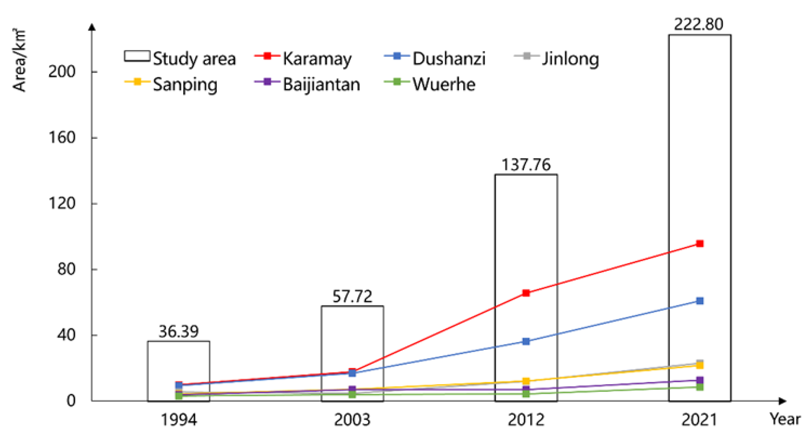
3.1. Expansion of Urban Construction Land

Karamay has undergone urban expansion over the last three decades, which can be observed from the continuous expansion of its urban land (Figure 3). From 1994 to 2003, the growth of urban construction land was relatively slow and the expansion was not apparent. From 2003 to 2012, a new urban district of Karamay was developed south of the Karamay River; government buildings, public facilities, and several large residential quarters were mass built there. Locals use “Henan” (which means “south of river” in Chinese) to refer to this new area and “Hebei” (“north of river”) to refer to the old area. At the same time, a new petrochemical industry park was built north of Dushanzi, which occupied a large amount of land. This was why urban construction land expanded significantly in the two townships during this time. Besides, Jinlong and Sanping gradually developed during this period. From 2012 to 2021, Karamay district and Baijiantan district gradually linked together due to the expansion in Jinlong, Sanping, as well as areas near the road connecting Karamay and Baijiantan.
From the perspective of distribution and development in each township, urban construction land developed earlier in Karamay and Dushanzi, and Karamay has always been the core area with the most concentrated distribution of construction land. After 2003, construction land in Jinlong and Sanping began to expand gradually and increased after 2012. However, in the past two decades, the construction land in Wuerhe was the lowest, with a slight increase.
Figure 4 shows the temporal changes in urban construction land area in each district during 1994–2021. The total urban land area increased from 36.39 km2 in 1994 to 219.80 km2 in 2021, with an increase of 501.76%. Four administrative districts retained the continued growth of construction land at a different rate. Before 2003, the area of Baijiantan district, which consisted of three townships (Jinlong, Sanping, and Baijiantan), was the largest, but with the rapid expansion of Karamay, Karamay district became the largest district. Dushanzi district also maintained stable and significant growth during the study period and exceeded the Baijiantan district between 2003 and 2012. Wuerhe had the lowest distribution of construction land, which was only within 4.34 km2 before 2012. After 2012, construction land in Wuerhe began to increase more quickly and reached 8.52 km2 in 2021.
The values of URG are given in Table 2.
It can be observed that for the entire study area, the expansion of construction land during the last two periods was much faster than in the first period. Different characteristics were presented in different townships, as described below.
Karamay expanded at a fast rate throughout the entire study period. The UGR was first at 6.7 with an annual expansion of 0.88 km2 during 1994–2003 and reached the highest UGR of 15.55 during 2003–2012, with an annual expansion of 5.31 km2. After 2012, the rate decreased to 4.28, with an annual expansion of 3.35 km2.
Dushanzi was similar to Karamay for its UGR during 2003–2012 was faster than the two periods before and after. However, compared with Karamay, the UGR of Dushanzi during 2012–2021 did not drop much, for the State-level Kuitun-Dushanzi Economic and Technological Development Zone was established, and industrial parks were speedily developed in this period at the border between Dushanzi and Kuitun city.
Jinlong showed negative growth during 1994–2003, but from 2003 to 2012, the UGR of Jinlong increased to 10.98 with an annual expansion of 0.81 km2. After that, the rate slightly dropped to 7.52 with an annual expansion of 1.04 km2.
Sanping maintained a steady growth with a UGR of around 6 during the study period.
Urban expansion in Baijiantan and Wuerhe fluctuated. During 2003–2012, urban growth almost stagnated in the two townships, with annual expansions of 0.01 km2 and 0.04 km2, respectively. The rate increased during 2012–2021, and the UGR of Wuerhe was the highest among the six townships during this period.
The values of UDI are given in Table 3.
It can be observed that for the entire study area, the proportion of urban construction land grew steadily from 4.67% to 24.18%, and there is still plenty of unused land available for urban growth. The share of urban construction land in Dushanzi and Wuerhe was much higher than that of other townships, 46.52% and 64.31%, respectively, while other townships were less than 30% in 2021. The share of construction land in Karamay reached 24.01% in 2021. Three oil production-based townships (Jinlong, Sanping, and Baijiantan) have intensities ranging from 15% to 25% in 2021.
In general, the urban area expanded rapidly during the 27 years of this study, and there are two explanations for this phenomenon. First, the “city-enterprise integration” system enabled the city government to have sufficient funds for urban construction consistently, and this was especially evident early on. Funds for urban construction came not only from the local government and enterprises but also from China National Petroleum Corporation (CNPC) [36]. Second, the state has placed increasing emphasis on Xinjiang since 2010; as one of the most important cities in Xinjiang, Karamay city greatly benefited from a series of state-level corresponding policies, which also contributed to urban expansion [37,38].

3.2. Orientation of Urban Expansion

The orientation of urban expansion is shown in Figure 5. In general, there are two stages of urban expansion regarding expansion direction: before 2003, the urban land sprawled around each township; after 2003, the expansion had an obvious dominant direction. This is in line with the spatial distribution of urban construction land in Figure 3.
In Karamay, the construction land developed rapidly in the SE and S directions after 2003, especially in the SE direction. The urban land developed from 1.98 km2 in 1994 to 54.67 km2 in 2021 in the southeast, with a contribution rate of 61.38%, and developed from 1.48 km2 in 1994 to 25.29 km2 in 2021 in the south, with a contribution rate of 27.74%. The expansion in the two directions was determined by the consistent development of the Henan area, as well as an urban agricultural development zone located in the south of Karamay. In contrast, the Hebei area had hardly any growth.
Urban land in Jinlong has been mostly distributed in the E direction during the study period. The east has also been one of the main directions for expansion in Jinlong. One change was that besides the E direction, the construction land expanded more in the SE direction before 2012, when the expansion was transferred to the N and NE directions.
Expansion in Sanping was similar to Jinlong, with the east as the dominant direction. Except for Sanping, the construction land was mostly distributed in S and SW directions before 2003, turned east after 2003, and developed in NE, E, SE, and S directions after 2012.
The southeast-northeast axis had been the dominant direction for urban construction in Baijiantan most of the time, which is the same direction as the G217 national highway, which passes throughout Baijingtan. Especially after 2012, there was a rapid expansion in the SW direction.
Combined with the township distribution in Figure 2, it is obvious that after 2012, urban land expansion in the four townships mentioned above brought them closer to each other, and they gradually became integrated.
Urban land in Dushanzi has been mostly distributed north of the township center. The expansion direction was towards Kuitun city, which is separated by the G312 national highway from Dushanzi.
As for Wuerhe, the share of construction land in the NW and N was always the highest in the same period (from 10.48% to 22.49%), and the domain directions of expansion hardly changed. The reason was the limitation of the local irregular Yadan landform and restrictions on cultivated land developed by the Xinjiang Production and Construction Corps (XPCC).

3.3. Urban Compactness

Urban compactness is considered an important feature that reflects the pattern of urban expansion and a solution to the problems caused by urban sprawl [34]. Scholars classified urban growth into three types: infilling, edge expansion, and outlying [39]. Regarding urban expansion, infilling type is considered the internal enrichment phase, and edge expansion and outlying types are considered the external expansion phase [40].
Values of overall urban compactness in 1994, 2003, 2012, and 2021 were calculated by Equation (3). As Table 4 shows, the average value for the entire study area of each stage was between 0.32 and 0.46. The compactness value decreased from 0.46 in 1994 to 0.32 in 2012, then increased to 0.38 in 2021. This indicates that urban expansion before 2012 was more external than internal enrichment. After 2012, urban expansion gradually transformed into an internal enrichment phase, and the city expanded but became compact.
From the perspective of each township, it can be observed that Karamay, Dushanzi, and Jinlong were the most compact in 1994 and least compact in 2012. A common feature is that the three townships are crucial to the oil industry. Karamay is the location of the headquarters of various enterprise units, there with large tracts of industrial storage land, while Dushanzi and Jinlong are the sites of refineries. Therefore, Karamay city’s urban plans paid more attention to these townships. The similar changes in compactness in the three townships indicated a transformation of Karamay city’s urban construction logic from extensive development to intensive development, which is in line with China’s national policy. In addition, large areas of water and green space were developed at the junction of Karamay and Jinlong, which promoted the improvement of the compactness of the two townships by way of infilling development.
Sanping and Baijiantan showed fluctuations of increase, decrease, then increase, which is mainly due to the placement and turnover of the subordinate units of the CNPC Xingjiang. In industrial cities, changes in the location of industrial enterprises often lead to the emergence of brownfields or vacant land. Since 2004, the idea of establishing a petrochemical industrial park made urban planners integrate the two townships into the city master plan (2014–2030), which contributed to the increase in compactness after 2012.
However, Wuerhe continued to decline in compactness during the entire study period. In addition to the limitations of the natural environment and cultivated land, one possible reason was the consistent development of the tourism industry, which required the construction of infrastructure and service facilities close to tourism resources.
In general, China’s mining cities tend to be scattered, with a compactness of 0.1–0.3. Mining cities in the northwest and northeast are less compact than the central and southwest [24]. However, in this study, we found that overall compactness in Karamay city was higher than in most of the other mining cities from the perspective of the townships.
Figure 6 shows the changes in the concentration of each township. The concentration of single townships and the whole study area has continued to increase during the entire study period.
In 1994, the degree of concentration was extremely low for two main reasons. On the one hand, industrial land and storage land accounted for a large proportion of urban area in mining cities, and without the guidance and constraints of urban planning in the early days, these lands occupied a large area of urban space. On the other hand, Karamay city has very significant characteristics of the Danwei unit [41]. The Danwei unit served as a multifunctional urban institution encompassing various aspects of urban livelihoods. Each Danwei created its own housing, schools, shops, services, etc. Due to the influence of the Danwei unit, various functions of the city are scattered, resulting in a waste of land.
As mentioned above, Karamay has been in the mature stage of resource-based city development. The urban economy grew very rapidly during the study period. Economic growth brought opportunities for urban construction, and large-scale residential areas and commercial areas gradually formed under the lead of agglomeration economy and urban planning. The original independent Danwei unit had gradually transformed into functional agglomeration. Large, inefficiently utilized urban land occupied by units has gradually been developed more effectively, which promoted the increase of the degree of urban concentration.
Furthermore, for Karamay city, where there was almost no existence of water, green space, or cultivated land originally, the development of urban agriculture and the construction of wetlands and green spaces have further promoted the concentration and the land use efficiency of developable land within the city [33].

4. Discussion

4.1. Socioeconomic Factors and Multilevel Policies Influencing Urban Expansion

The expansion of construction land is often affected by the natural environment and socioeconomic factors. The natural environment includes ecological conditions and natural resources [42,43,44,45]; the socioeconomic factors include population, economy, industrial structure, policy, and urbanization process [8,17,46]. As far as a certain area is concerned, natural environment factors are relatively stable, while socioeconomic factors often become the main influencing factors of urban development in a certain period [47].
Therefore, combined with the situation of Karamay city and the availability of data, this study analyzed factors affecting urban expansion from a socioeconomic perspective. In the study, the area of urban construction land of the existing four years was interpolated to obtain the construction land area of each year from 1994 to 2021, which was set as the dependent variable. Multiple potential driving factors affecting urban spatial expansion were selected as independent variables (GDP, population, output value of three sectors, industrial structure, public finance revenue and expenditure, and investment in fixed assets), and a stepwise regression analysis method was used to build the model. The R2 was 0.989, which satisfied the significance test (Table 5). From the regression results, the main factors affecting the expansion of urban construction land area in the study area are public finance expenditure, population, and the output value of the tertiary industry. The coefficients were 0.650, 0.271, and 0.100, respectively. As Table 6 shows, from the results of the correlation analysis, the correlation coefficients between the urban construction land and public finance expenditure, population, and the output value of the tertiary industry were 0.988, 0.982, and 0.831, respectively.
The total population of the study area increased by 266,100 from 1994 to 2021. Population growth is one of the important drivers of Karamay’s urban expansion. The increase in population led to increased urban construction land needed for living and production. This is consistent with the existing literature that demographic factors are one of the main factors affecting urban expansion in China [47].
In addition, an interesting finding is that government finance expenditure has a significant impact on urban expansion in Karamay city. This factor has not been mentioned much in other urban expansion studies. As mentioned above, Karamay city is a national resource and industrial base established in the 1950s, the city has been implementing the “city-enterprise integration” system, and the head of the CNPC Xinjiang also serves as the head of the municipal government. This gives the city government sufficient financial resources and flexibility to use the rich revenue of the oil industry to support urban construction. It can be found that during the study period, many infrastructures, such as train stations and airports, as well as facilities for public services such as education and health care, were massively built, which will lead to urban construction land expansion.
Furthermore, previous studies have generally found a negative correlation between the development of the tertiary industry and urban expansion. Still, in Karamay’s case, the development of the tertiary industry and urban expansion are positively correlated. There are two possible reasons for this. First, as a city developed entirely by the oil industry, the secondary industry is the pillar industry of Karamay, accounting for more than 90% of the economy. Therefore, the construction of urban facilities in the early period mainly served the oil industry and citizens living needs. With the development of the tertiary industry, the land and large-scale facilities serving the tertiary industry have increased substantially, which leads to the expansion of urban land. Second, the development of the tertiary industry has improved the lifestyle of residents, further promoting the demand for green open space and suburban ecological land [11], which is in line with the fact that the greening rate of Karamay city has continued to increase. The number and area of parks and wetlands have continued to grow.
In addition, China’s urban development is greatly influenced by the government, and the government guides urban construction through a series of planning policies. Karamay has long relied on the development of oil resources and, in the late 1990s, began to work on industrial transformation. Correspondingly, the city master plan (1996–2006) put forward the general goal of developing emerging industries and developing Karamay into the regional central city of northern Xinjiang. Since then, the Karamay township has continued to expand southward; new administrative areas, agricultural development zone, university towns, and industrial parks for emerging businesses have been developed in the following 20 years. The transportation facilities within and outside the city have also developed rapidly. In 2004, a petrochemical industrial park and a high-tech industrial development zone were planned based on Jinlong and Sanping townships, which promoted construction land expansion. In 2022, the State Council approved the upgrading of the high-tech industrial development zone to a national industrial park, which is expected to be further developed. The urban expansion of Dushanzi was also mainly due to the construction of industrial facilities and petrochemical industrial parks, which occupy large areas and have been leading the expansion since 2003. The urban growth of Wuerhe was led by local policies to develop the tourism industry. With the improvement in transportation, more and more tourists have traveled to Xinjiang; as the hinterland city of northern Xinjiang, the local government aspired to turn the city into a travel destination instead of an alternative stopover. The government made a great effort to brand the local Yardang landscape as a spot called “Devil City”, also known as “Wuerhe Wind City”, and built a “Western Wuzhen” characteristic town under the upsurge of the national development of characteristic towns.
We found that the dominant industrial force for expansion varies. Karamay’s expansion was driven by emerging and high value-added industries, such as cloud computing and higher education; expansion in Jinlong, Sanping, Baijiantan, and Dushanzi was driven by agglomerated oil and petrochemical industries; expansion in Wuerhe was driven by tourism.

4.2. A Trend toward Compactness

Influenced by oil resources and production methods, Karamay has historically formed a decentralized urban spatial layout of “multi-townships”, which were geographically dispersed.
In the process of Karamay’s transformation from an oil city to a comprehensive city, these townships shifted from targeting population and facility agglomeration to meet oil production needs to expanding the size of the city and attracting population growth. In the 1996 edition of the city master plan, to enhance the urban service function, a spatial reorganization plan was drawn up to develop a new district, which plays the role of the central urban area on the southern side of Karamay township. An industrial park for the petroleum and petrochemical industry was established in Jinlong and Sanping townships. The industrial functions within Karamay township were transferred there to promote the agglomeration of industrial functions. Therefore, urban compactness showed a downward trend between 1996 and 2012, slowly recovering after 2012. A possible explanation is that the planning of an ambitious new district and new industrial park usually encompasses a large area of land. Still, it takes decades of construction and development to utilize the encircled land effectively. However, it is worth noting that in existing studies, the construction of industrial parks led to a jump in the growth of cities [48] and lower compactness. However, this study found that in cities with scattered spatial structures, the park established based on the existing township reduces the compactness of the space in the early stage but helps increase compactness after. This is because the park’s construction connects the originally scattered townships and promotes the infill development of the urban areas.
In addition, government policy and strategy also reflected the city’s desire for compact development. In the 2006 edition of the city master plan, a strategy called “grouping planning to achieve overall development” was proposed to guide the formation of mesoscale urban space based on the spatial layout of the townships. Then, in the 2014 version of the plan, the “Karamay-Baijiantan group”, which consists of four townships, Karamay, Jinlong, Sanping, and Baijiantan, was further designated as the city center area. This was the first recognized broadening of the scope of Karamay’s urban center area. While the other three townships undertake the majority of the secondary industrial function, Karamay township, as a political, economic, and cultural center, can have a more rational and pleasant urban environment for future development. This is the embodiment of the compactness of urban functions.
Compared to other cities, the development characteristics of mining cities made most mining cities have an inherently dispersed spatial structure and relatively clear functional divisions. In particular, the urban area consists of multiple “townships”, and the industrial space where the resource extraction industry and primary resource processing industry are located is generally clearly separated from other functional spaces in the city. Therefore, when the city transforms, the reorganization of urban space and functions becomes the main performance of urban space changes. The scattered urban spatial structure of the mining city has increased the flexibility with its spatial development, and the original large area of industrial space has provided relatively sufficient land and coordination for the city’s new functional space. This is conducive to the improvement of urban land use efficiency and urban compactness if the characteristics are valued and utilized by urban planners.

4.3. Suggested Strategies for Future Development

The number of mining cities accounts for 37% of all cities in mainland China [22]. In the context of today’s decarbonization trend in response to global warming, the transformation of mining cities is related to the sustainable development of the entire country. Although Karamay city is still in a period of prosperity, it also faces the risk of urban decline brought by the depletion of oil resources and the change in energy structure. Industrial transformation plays a key role in the transformation of mining cities and affects the urban spatial pattern [49,50]. The urban expansion process of Karamay city happened against such a global background.
However, rapid urban expansion often exacerbates land-use contradictions and eventually becomes a restrictive factor for regional sustainable development [51,52]. Although the land-use conflict in Karamay city is not as severe as most cities that expand with the urbanization process, some strategies should still be considered to control urban sprawl considering the unoptimistic population growth in the context of an aging society and energy consumption problems in the context of carbon neutrality. Although Karamay city is becoming compact to a certain extent, it should be noted that the population density of Karamay’s urban built-up area in 2020 was 4186 people per square kilometer, much below the UN standard, while the UN-Habitat recommended density for compact development is at least 15,000 people/km2 in a central city area and 6750–10,000 people/km2 in the fringe areas of a city [53]. Therefore, the compact city strategy should become the core of urban planning and development in Karamay city in the future.
First, government policy and planning are important factors in urban land development. Land-use policies often have an important impact on the location and scale of future urban spatial development and play a decisive role in guiding the formation of urban spatial patterns. To date, studies have confirmed the effectiveness of city master planning [54], urban growth boundaries [55], and other strategies for controlling urban sprawl that have been adopted in Karamay city. Moreover, the local government’s document also highlights part of the development principles of the compact city strategy, such as land conservation, improved public transport, and low-carbon development. However, in Karamay city, the compact city strategy still lacks comprehensive planning, measures, and regulatory guidance. More specific land-use and transportation policies should be proposed according to local conditions to promote compact urban development.
Secondly, reducing energy consumption and carbon emissions is also one of the core goals of the compact city strategy [33]. Promoted land-use and transport policies help improve energy consumption patterns, but energy production patterns are equally important. As a conventional energy production base, promoting the exploitation of clean energy is an important part of Karamay city’s industrial transformation. According to Karamay city’s “14th Five-Year” Plan for New Energy Development [56], the city will focus on developing solar and wind energy. To date, some solar and wind energy facilities have been built to generate electricity for cloud computing industrial parks and several oil fields (Figure 7). However, a leader from the New Energy Research Institute of CNPC Xinjiang told us, “Now, the renewable energy development in Karamay city is still in the experimental stage. The cost of electricity generation using solar or wind energy is much higher than the price of traditional coal-fired electricity, which makes the wide range of applications difficult. Currently, the operation of new energy facilities mostly relies on the policy inclination and subsidy from the government and CNPC”. Other studies also noted that policy and financial subsidies have a huge impact on the change in energy structure in China [57,58]. Fortunately for Karamay city, the national government proposed the “Belt and Road” initiative in 2013, and in 2020 put forward the principle of “green development” as the top priority in the development of the “Belt and Road” initiative [59]. The development and utilization of clean energy were specifically emphasized. As an important node city along the Belt and Road, Karamay should seize the policy opportunities. On the one hand, more efforts should be made to utilize renewable energy and smart grid technologies to serve the city more efficiently, for example, promoting applications in more public service facilities, such as parks, squares, and street lighting. On the other hand, it is important to consider integrating clean energy facilities into the local special Gobi landscape and oil field landscape, which will not only help improve the urban landscape but also have an educational aspect.
Moreover, greening is one of several key design concepts for sustainable urban forms. More parks and green spaces are perceived as having positive effects on the environment, health, and recreation [60,61,62]. The proponents of the compact city strategy believe that improving land use efficiency will help to leave more area for green space and emphasize that greening is one of the principles of compact cities. As mentioned above, both the number and area of green spaces in Karamay city increased significantly during the study period. However, it should be pointed out that high-quality parks and wetlands are concentrated in the Henan new district, which suggests that equitable accessibility to green land should receive attention in the future. In addition, Karamay is located in the desert climate zone where the natural environment is harsh. The concept of green infrastructure that combines green land, waterways, reservoir, park, and farmland into one common structure should be given attention, promoting regional ecological security and sustainable development.

5. Conclusions

Urban expansion has been a hot topic for many years. The physical expansion of cities typically takes the form of urban sprawl, driven by multiple factors, and has multiple effects on the economy, society, and the environment [63]. Policymaking has heavily emphasized the need to limit urban sprawl and its numerous negative effects by encouraging compact urban growth. However, most existing research targeted metropolises and urban agglomerations, resulting in insufficient research on urban development in different regions and backgrounds. Cities in places such as northern China are rich in land resources, and urban expansion can easily lead to low land-use efficiency and urban sprawl. Therefore, this study took Karamay as a case study, a city characterized by a scattered urban spatial structure, to explore the temporal and spatial evolution characteristics of urban construction land during the transformation period of Karamay city.
This study shows that Karamay city has continued to expand in the past 30 years; socioeconomic (population, local finance expenditure, tertiary industry development) and urban planning policy are the main factors affecting its urban expansion. During expansion, urban compactness initially declined, but there was a trend toward more compactness. Karamay’s urban space has gradually transformed from the original scattered distribution of townships to functionally concentrated urban areas, which demonstrates part of the design strategy of the compact city and suggests the possibility for further compact growth. The urban development pattern obtained in this study provides a more scientific decision-making basis for the subsequent urban development of Karamay city and is conducive to the rational planning of urban transformation. This study is the first to combine urban expansion with the scattered characteristics of mining cities to analyze changes in urban compactness in the context of mining city transformation. Several strategies for future urban development were proposed accordingly, which has significance as a reference for the sustainable development of such cities and provides a case background for future discussion about compact urban growth in various urban contexts.
Finally, this study investigates the overall evolution of urban space and the urban structure of the city. At the same time, it does not make a detailed exploration of the function distribution within the urban area. It is necessary to study the changes in urban function distributions further to make Karamay city’s case study more complete. And it is also important to note that this study can be improved from a methodological perspective by more carefully analyzing physical and socioeconomic factors that drive urban development. For example, recent research has proposed a patch-generating land use simulation model available to simulate the change of land use patches and to analyze the underlying drivers of land use dynamics [64]. Applying that method to analyze the driving factors of urban expansion may help to improve our understanding further.

Author Contributions

Conceptualization, Y.P.; Data curation, Y.P.; Formal analysis, Y.P.; Funding acquisition, Y.P.; Investigation, Y.P. and T.I.; Methodology, Y.P.; Supervision, M.F.; Writing—original draft, Y.P.; Writing—review & editing, Y.P., M.F. and T.I. All authors have read and agreed to the published version of the manuscript.

Funding

This work was supported by JST SPRING, Grant Number JPMJSP2114.

Data Availability Statement

The data will be made available upon request from the corresponding author.

Conflicts of Interest

The authors declare no conflict of interest. The funders had no role in the design of the study; in the collection, analyses, or interpretation of data; in the writing of the manuscript, or in the decision to publish the results.

References

  1. UN Habitat. Enhancing Urban Safety and Security: Global Report on Human Settlements 2007; Earthscan Publications: London, UK, 2012. [Google Scholar]
  2. Seto, K.C.; Fragkias, M.; Güneralp, B.; Reilly, M.K. A Meta-Analysis of Global Urban Land Expansion. PLoS ONE 2011, 6, e23777. [Google Scholar] [CrossRef] [PubMed]
  3. Song, X.; Liu, Y.; Zhu, X.; Cao, G.; Chen, Y.; Zhang, Z.; Wu, D. The Impacts of Urban Land Expansion on Ecosystem Services in Wuhan, China. Environ. Sci. Pollut. Res. Int. 2022, 29, 10635–10648. [Google Scholar] [CrossRef] [PubMed]
  4. Lu, J.; Li, B.; Li, H.; Al-Barakani, A. Expansion of City Scale, Traffic Modes, Traffic Congestion, and Air Pollution. Cities 2021, 108, 102974. [Google Scholar] [CrossRef]
  5. Zhao, M.; Cai, H.; Qiao, Z.; Xu, X. Influence of Urban Expansion on the Urban Heat Island Effect in Shanghai. Int. J. Geogr. Inf. Sci. 2016, 30, 2421–2441. [Google Scholar] [CrossRef]
  6. Du, N.R.; Otterns, H.; Sliuzas, R. Spatial impact of urban expansion on surface water bodies—A case study of Wuhan, China. Landsc. Urban Plan. 2010, 94, 175–185. [Google Scholar] [CrossRef]
  7. Li, S.; He, Y.; Xu, H.; Zhu, C.; Dong, B.; Lin, Y.; Si, B.; Deng, J.; Wang, K. Impacts of Urban Expansion Forms on Ecosystem Services in Urban Agglomerations: A Case Study of Shanghai-Hangzhou Bay Urban Agglomeration. Remote Sens. 2021, 13, 1908. [Google Scholar] [CrossRef]
  8. Tong, D.; Chu, J.; Han, Q.; Liu, X. How Land Finance Drives Urban Expansion under Fiscal Pressure: Evidence from Chinese Cities. Land 2022, 11, 253. [Google Scholar] [CrossRef]
  9. Barau, A.S.; Maconachie, R.; Ludin, A.N.M.; Abdulhamid, A. Urban morphology dynamics and environmental change in Kano, Nigeria. Land Use Policy 2015, 42, 307–317. [Google Scholar] [CrossRef] [Green Version]
  10. Jinlong, C. Quantitative Analysis of Urban Spatial Form; Southeast University Press: Nanjing, China, 2007; Volume 6. [Google Scholar]
  11. Gao, J.; Wei, Y.D.; Chen, W.; Chen, J. Economic transition and urban land expansion in Provincial China. Habitat Int. 2014, 44, 461–473. [Google Scholar] [CrossRef]
  12. Huang, B.; Zhang, H.; Song, D.; Ma, Y. Driving forces of built-up land expansion in China from 2000 to 2010. Acta Ecol. Sin. 2017, 37, 4149–4158. [Google Scholar]
  13. Yue, W.; Fan, P.; Wei, Y.D.; Qi, J. Economic development, urban expansion, and sustainable development in Shanghai. Stoch. Environ. Res. Risk Assess. 2014, 28, 783–799. [Google Scholar] [CrossRef]
  14. Li, H.; Wei, Y.H.D.; Huang, Z. Urban Land Expansion and Spatial Dynamics in Globalizing Shanghai. Sustainability 2014, 6, 8856–8875. [Google Scholar] [CrossRef] [Green Version]
  15. Chen, J.; Gao, J.; Chen, W. Urban land expansion and the transitional mechanisms in Nanjing, China. Habitat Int. 2016, 53, 274–283. [Google Scholar] [CrossRef]
  16. Tong, L.; Hu, S.; Frazier, A.E. Hierarchically measuring urban expansion in fast urbanizing regions using multi-dimensional metrics: A case of Wuhan metropolis, China. Habitat Int. 2019, 94, 102070. [Google Scholar] [CrossRef]
  17. Chen, J.; Chang, K.-T.; Karacsonyi, D.; Zhang, X. Comparing urban land expansion and its driving factors in Shenzhen and Dongguan, China. Habitat Int. 2014, 43, 61–71. [Google Scholar] [CrossRef]
  18. Ma, Y.; Xu, R. Remote sensing monitoring and driving force analysis of urban expansion in Guangzhou City, China. Habitat Int. 2010, 34, 228–235. [Google Scholar] [CrossRef]
  19. Wu, W.; Zhao, S.; Zhu, C.; Jiang, J. A comparative study of urban expansion in Beijing, Tianjin and Shijiazhuang over the past three decades. Landsc. Urban Plan. 2015, 134, 93–106. [Google Scholar] [CrossRef]
  20. Gao, J.; Wei, Y.D.; Chen, W.; Yenneti, K. Urban land expansion and structural change in the Yangtze River Delta, China. Sustainability 2015, 7, 10281–10307. [Google Scholar] [CrossRef] [Green Version]
  21. Liu, J.; Zhang, Q.; Hu, Y. Regional differences of China′s urban expansion from late 20th to early 21st century based on remote sensing information. Chin. Geogr. Sci. 2012, 22, 1–14. [Google Scholar] [CrossRef]
  22. The State Council. Quanguo Ziyuanxing Chengshi Kechixu Fazhan Guihua (2013–2020) [The Plan for the Sustainable Development of Resource-Based Cities in China (2013–2020)]; Government document; The State Council: Beijing, China, 2013.
  23. Long, R.Y.; Chen, H.; Li, H.J.; Wang, F. Selecting alternative industries for Chinese resource cities based on intra- and inter-regional comparative advantages. Energy Policy 2013, 57, 82–88. [Google Scholar] [CrossRef]
  24. Yang, S.; Shijun, W. Mining Urban Space: Pattern, Progress, Mechanism; Science Press: Beijing, China, 2011. [Google Scholar]
  25. Honglie, Y. Planning and Construction of China’s Petroleum City; Petroleum Industry Press: Beijing, China, 1966; Volume 3. [Google Scholar]
  26. Blau, E. Baku: Oil and Urbanism; Park Books: Zurich, Switzerland, 2018; pp. 20–23. [Google Scholar]
  27. National Bureau of Statistics of China. China Population Census Yearbook 2020; China Statistics Press: Beijing, China, 2022.
  28. The State Council of the People’s Republic of China. China to Apply New City Classification Standards. Available online: https://www.gov.cn/zhengce/content/2014-11/20/content_9225.htm (accessed on 2 November 2022).
  29. Karamay Annual; Xinjiang People’s Publishing House: Wulumuqi, China, 1998.
  30. Karamay Statistical Yearbook 2020; Chinese Literature and History Press: Beijing, China, 2020.
  31. Xue, M.; Zhang, X.; Sun, X.; Sun, T.; Yang, Y. Expansion and Evolution of a Typical Resource-Based Mining City in Transition Using the Google Earth Engine: A Case Study of Datong, China. Remote Sens. 2021, 13, 4045. [Google Scholar] [CrossRef]
  32. Galster, G.; Hanson, R.; Ratcliffe, M.R.; Wolman, H.; Coleman, S.; Freihage, J. Wrestling Sprawl to the Ground: Defining and measuring an elusive concept. Hous. Policy Debate 2001, 12, 681–717. [Google Scholar] [CrossRef]
  33. Bibri, S.E.; Krogstie, J.; Kärrholm, M. Compact City Planning and Development: Emerging Practices and Strategies for Achieving the Goals of Sustainable Development. Dev. Built Environ. 2020, 4, 100021. [Google Scholar] [CrossRef]
  34. Fang, C.; Qi, W. Research progress and thinking of compact city and its measurement methods. Urban Plan. Forum 2007, 4, 65–73. [Google Scholar]
  35. Batty, M. Cities as Fractals: Simulating Growth and Form; Springer: New York, NY, USA, 1991; pp. 43–69. [Google Scholar]
  36. Xinjiang Chronicle: Petroleum Industry; Xinjiang People’s Publishing House: Wulumuqi, China, 1999.
  37. Yu, H. Motivation behind China’s “One Belt, One Road” Initiatives and Establishment of the Asian Infrastructure Investment Bank. J. Contemp. China 2016, 26, 353–368. [Google Scholar] [CrossRef]
  38. Xu, L.J.; Fan, X.C.; Wang, W.Q.; Xu, L.; Duan, Y.L.; Shi, R.J. Renewable and sustainable energy of Xinjiang and development strategy of node areas in the “Silk Road Economic Belt”. Renew. Sustain. Energy Rev. 2017, 79, 274–285. [Google Scholar] [CrossRef]
  39. Sun, C.; Wu, Z.F.; Lv, Z.Q.; Yao, N.; Wei, J.B. Quantifying different types of urban growth and the change dynamic in Guangzhou using multi-temporal remote sensing data. Int. J. Appl. Earth Observ. Geoinform. 2013, 21, 409–417. [Google Scholar] [CrossRef]
  40. Zhang, X.; Bai, Z.; Fan, X.; Lu, Y.; Cao, Y.; Zhao, Z.; Sun, Q.; Pan, J. Urban Expansion Process, Pattern, and Land Use Response in an Urban Mining Composited Zone from 1986 to 2013. J. Urban Plan. Dev. 2016, 142, 04016014. [Google Scholar] [CrossRef]
  41. Chai, Y. From socialist danwei to new danwei: A daily-life-based framework for sustainable development in urban China. Asian Geogr. 2014, 31, 183–190. [Google Scholar] [CrossRef]
  42. Chengxin, W.; Wangsheng, D.; Yu, C.; Kai, L. Spatial Expansion and Driving Force of Jinan City in the Stage of Rapid Urbanization. Sci. Geogr. Sin. 2020, 40, 1513–1521. [Google Scholar]
  43. Zhang, Z.; Liu, H.; Yang, Y. Urban spatio-temporal expansion process for resource-exhausted cities: A case study of Huaibei city. Geogr. Res. 2018, 37, 183–198. [Google Scholar]
  44. Zhao, M.; Cheng, W.; Liu, Q.; Wang, N. Spatiotemporal measurement of urbanization levels based on multiscale units: A case study of the Bohai Rim Region in China. J. Geogr. Sci. 2016, 26, 531–548. [Google Scholar] [CrossRef] [Green Version]
  45. Xiaohong, C.; Wenzhong, Z.; Haifeng, Z. The Relations of Urban Spatial Expansion and Economic Growth in China: A Case Study of 261 Prefecture-level Cities. Sci. Geogr. Sin. 2016, 36, 1141–1147. [Google Scholar]
  46. Xianjin, H. Urban Land Use Change and Its Response: Model Construction and Empirical Research; Science Press: Beijing, China, 2008; pp. 27–28. [Google Scholar]
  47. Ma, Q.; He, C.; Wu, J. Behind the rapid expansion of urban impervious surfaces in China: Major influencing factors revealed by a hierarchical multiscale analysis. Land Use Policy 2016, 59, 434–445. [Google Scholar] [CrossRef]
  48. He, Q.; Zhou, J.; Tan, S.; Song, Y.; Zhang, L.; Mou, Y.; Wu, J. What Is the Developmental Level of Outlying Expansion Patches? A Study of 275 Chinese Cities Using Geographical Big Data. Cities 2020, 105, 102395. [Google Scholar] [CrossRef]
  49. He, S.Y.; Lee, J.; Zhou, T.; Wu, D. Shrinking Cities and Resource-Based Economy: The Economic Restructuring in China’s Mining Cities. Cities 2017, 60, 75–83. [Google Scholar] [CrossRef]
  50. Qian, X.; Wang, D.; Wang, J.; Chen, S. Resource curse, environmental regulation and transformation of coal-mining cities in China. Resour. Policy 2019, 74, 101447. [Google Scholar] [CrossRef]
  51. Angel, S.; Sheppard, S.; Civco, D.L.; Buckley, R.; Chabaeva, A.; Gitlin, L.; Kraley, A.; Parent, J.; Perlin, M. The Dynamics of Global Urban Expansion; World Bank, Transport and Urban Development Department: Washington, DC, USA, 2005. [Google Scholar]
  52. Jiang, L.; Deng, X.; Seto, K.C. The impact of urban expansion on agricultural land use intensity in China. Land Use Policy 2013, 35, 33–39. [Google Scholar] [CrossRef]
  53. UN Habitat. A New Strategy of Sustainable Neighbourhood Planning: Five Principles; United Nations Human Settlements Programme: Nairobi, Kenya, 2014. [Google Scholar]
  54. Sharifi, A.; Chiba, Y.; Okamoto, K.; Yokoyama, S.; Murayama, A. Can master planning control and regulate urban growth in Vientiane, Laos? Landsc. Urban Plan. 2014, 131, 1–13. [Google Scholar] [CrossRef]
  55. Gennaio, M.-P.; Hersperger, A.M.; Bürgi, M. Containing urban sprawl—Evaluating effectiveness of urban growth boundaries set by the Swiss Land Use Plan. Land Use Policy 2009, 26, 224–232. [Google Scholar] [CrossRef]
  56. China Energy Engineering Corporation Limited (Xinjiang). Karamay City’s “14th Five-Year” Plan for New Energy Development; Research Report; China Energy Engineering Corporation Limited (Xinjiang): Karamay, China, 2022. [Google Scholar]
  57. Ouyang, X.; Lin, B. Impacts of increasing renewable energy subsidies and phasing out fossil fuel subsidies in China. Renew. Sustain. Energy Rev. 2014, 37, 933–942. [Google Scholar] [CrossRef]
  58. Guo, Z.; Zhang, X.; Feng, S.; Zhang, H. The Impacts of Reducing Renewable Energy Subsidies on China’s Energy Transition by Using a Hybrid Dynamic Computable General Equilibrium Model. Front. Energy Res. 2020, 8, 25. [Google Scholar] [CrossRef]
  59. The National Development and Reform Commission. Outline of the 14th Five-Year Plan (2021–2025) for National Economic and Social Development and Vision 2035 of the People’s Republic of China; Government document; The National Development and Reform Commission: Beijing, China, 2021.
  60. Rupprecht, C.D.D.; Byrne, J.A.; Garden, J.G.; Hero, J.-M. Informal urban green space: A trilingual systematic review of its role for biodiversity and trends in the literature. Urban For. Urban Green. 2015, 14, 883–908. [Google Scholar] [CrossRef] [Green Version]
  61. Zhou, X.; Rana, M.P. Social benefits of urban green space. Manag. Environ. Qual. Int. J. 2012, 23, 173–189. [Google Scholar] [CrossRef]
  62. Lee, A.C.K.; Maheswaran, R. The health benefits of urban green spaces: A review of the evidence. J. Public Health 2010, 33, 212–222. [Google Scholar] [CrossRef] [Green Version]
  63. Artmann, M.; Inostroza, L.; Fan, P. Urban sprawl, compact urban development and green cities. How much do we know, how much do we agree? Ecol. Indic. 2019, 96, 3–9. [Google Scholar] [CrossRef]
  64. Liang, X.; Guan, Q.; Clarke, K.C.; Liu, S.; Wang, B.; Yao, Y. Understanding the drivers of sustainable land expansion using a patch-generating land use simulation (PLUS) model: A case study in Wuhan, China. Comput. Environ. Urban Syst. 2021, 85, 101569. [Google Scholar] [CrossRef]
Figure 1. Map showing Northwest China, as well as the location and spatial organization of Karamay city and the study area.
Land 11 02011 g001
Figure 2. Distribution of land use of each township in 1994, 2003, 2012, 2021. (a) from left to right: Karamay, Jinlong, Sanping, and Baijiantan; (b) Dushanzi; (c) Wuerhe.
Land 11 02011 g002
Figure 3. Spatial distribution of newly developed urban construction land from 1994 to 2021. (a) from left to right: Karamay, Jinlong, Sanping, and Baijiantan; (b) Dushanzi; (c) Wuerhe.
Land 11 02011 g003
Figure 4. Changes in the area of urban construction land from 1994 to 2021.
Land 11 02011 g004
Figure 5. Orientation of urban construction land expansion at each township in 1994, 2003, 2012, and 2021.
Land 11 02011 g005
Figure 6. Changes in the urban concentration of each township from 1994 to 2021.
Land 11 02011 g006
Figure 7. (left) One of the solar power plants in Karamay city. (right) Solar and wind power facilities in Fengcheng oilfield, Karamay city. (Photographed by one of the authors).
Land 11 02011 g007
Table 1. Basic information about study areas.
Township/
Study Area
Established (Year)Planed Urbanization Area (km2)Population
(Ten Thousand)
Characteristics
Karamay19551067.8227.56Political and economic center of Karamay city
Dushanzi1936219.278.92An enclave in Karamay city; Location of Xinjiang’s largest oil refinery
Jinlong1958305.871.73Location of another refinery in the city
Sanping1958350.750.66Location of No. 3 Oil Production Plant and petroleum institute
Baijiantan1955182.465.84Location of No. 2 Oil Production Plant and Oil Drilling Company
Wuerhe198339.770.74Yardang landscape nearby
Study area-2165.9445.45-
Note: Data of “Population (ten thousand)” are for 2019.
Table 2. Values of UGR.
UGR (%)Annual Expansion (km2)
1994–20032003–20122012–20211994–20032003–20122012–2021
Karamay6.7015.554.280.885.313.35
Dushanzi6.828.825.900.852.152.73
Jinlong−1.8110.987.52−0.090.811.23
Sanping5.676.096.500.310.561.04
Baijiantan6.700.156.850.340.010.64
Wuerhe2.361.027.780.080.040.46
Study area5.2610.155.492.378.899.45
Table 3. Values of UDI (%).
1994200320122021
Karamay1.733.1514.7824.01
Dushanzi6.8013.3926.4446.52
Jinlong5.885.1313.5425.04
Sanping3.175.245.0613.16
Baijiantan2.584.879.3915.46
Wuerhe27.4435.4142.0464.31
Study area4.675.2213.8024.18
Table 4. Values of urban compactness of each township in 1994, 2003, 2012, and 2021.
1994200320122021
Karamay0.620.470.310.33
Dushanzi0.520.300.200.41
Jinlong0.590.420.380.45
Sanping0.260.430.310.53
Baijiantan0.510.550.380.44
Wuerhe0.480.450.420.24
Average0.460.410.320.38
Table 5. Summary of the regression model.
Unstandardized
Coefficient
Standardized
Coefficients
Significance
(<0.05)
BStd. ErrorBeta
(Constant)−21.83426.333--
Public finance expenditure8.738 × 10−50.0000.6500.000
Population2.2370.5290.1000.029
Output value of the tertiary industry1.2440.9790.2710.033
R2 (adjusted) 0.989
Table 6. Summary of the correlations.
Pearson Correction
Coefficient
Significance
(<0.01)
Public finance expenditure0.9880.000
Population0.9820.000
Output value of the tertiary industry0.8310.000
Publisher’s Note: MDPI stays neutral with regard to jurisdictional claims in published maps and institutional affiliations.

