
Water Erosion Monitoring and Prediction in Response to the Effects of Climate Change Using RUSLE and SWAT Equations: Case of R’Dom Watershed in Morocco

 ,
,  , ,
, ,  ,
,  and
and 
Abstract
:1. Introduction
2. Materials and Methods
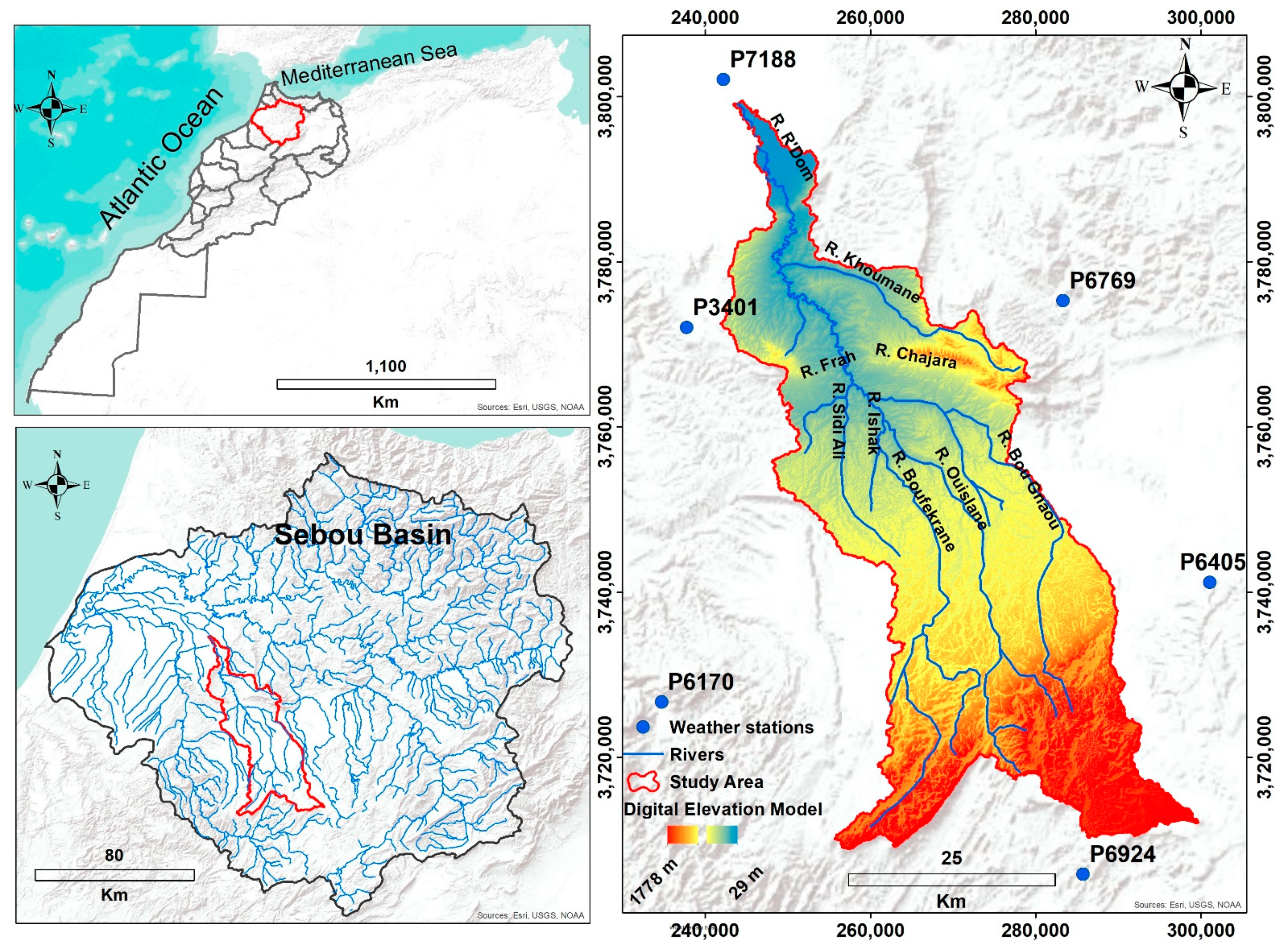
2.1. Study Area
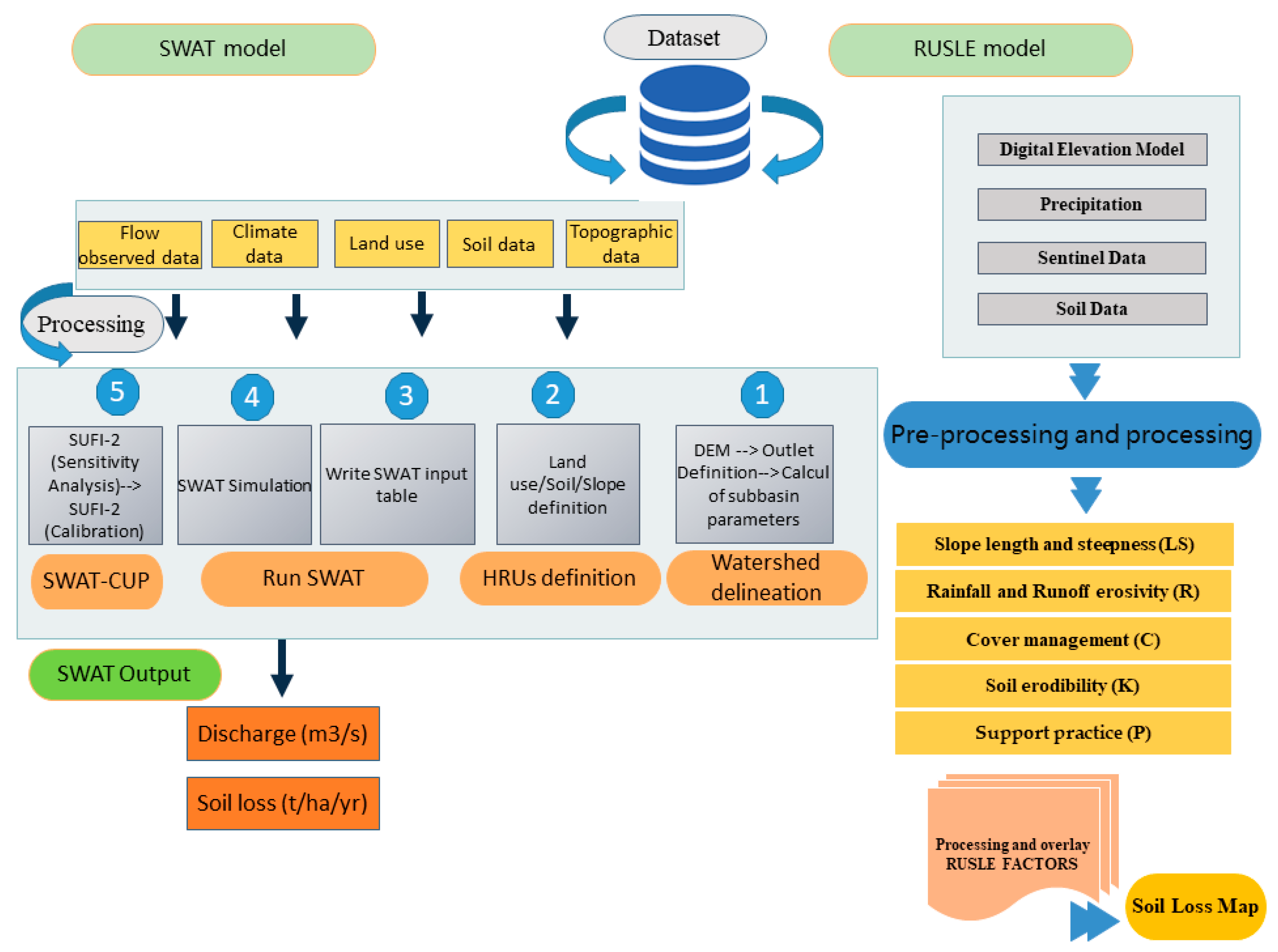
2.2. Data Used and Methodology

| Data | Spatial Resolution | Coordinate System | Source |
|---|---|---|---|
| Digital Elevation Model (DEM) | 30 m | UTM/WGS84 1, Zone 30 N | [47] |
| Land cover Map | 10 m | UTM/WGS84 1, Zone 30 N | [47] |
| Soil data | 30 m | UTM/WGS84 1, Zone 30 N | Field collection/reports |
| Climate data | 30 m | UTM/WGS84 1, Zone 30 N | Sebou Hydraulic Basin Agency (SHBA) |
2.2.1. Sentinel-2 Images
2.2.2. Digital Elevation Model (DEM)
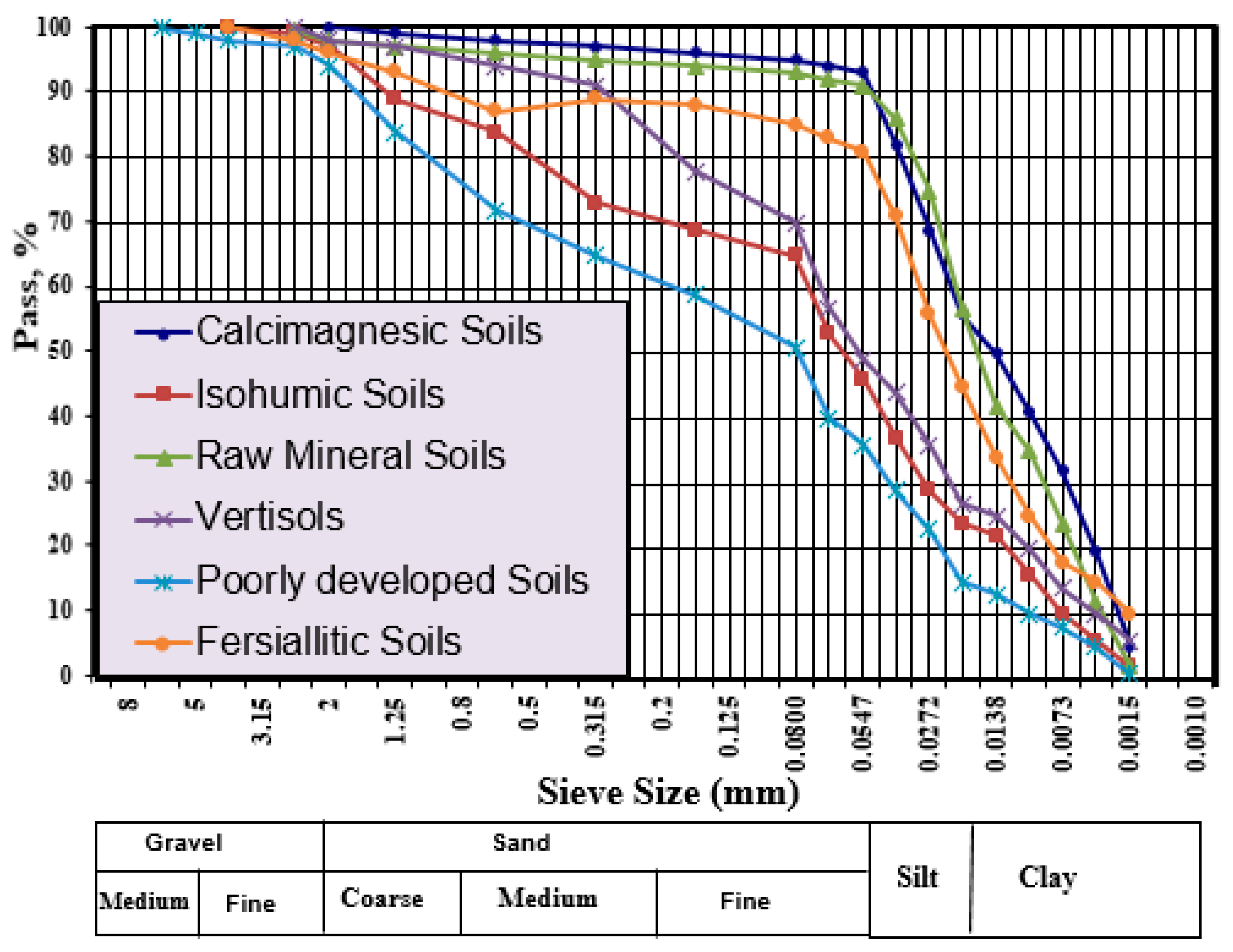
2.2.3. Soil Data
2.2.4. Climatic Data
2.3. Methodology Adopted
2.3.1. RUSLE Equation
- A is the computed average soil loss over a period selected for R, usually on yearly basis (t ha−1 y−1);
- R is the rainfall-runoff erosivity factor (MJ mm ha−1 h −1 y−1);
- K is the soil erodibility factor (t ha h ha−1 MJ−1 mm−1);
- LS is the slope length (L) and slope gradient (S) factor (dimensionless);
- C is the cropping management factor (dimensionless, ranging between 0 and 1);
- P is the supporting conservation practice factor (dimensionless, ranging between 0 and 1).
- A.
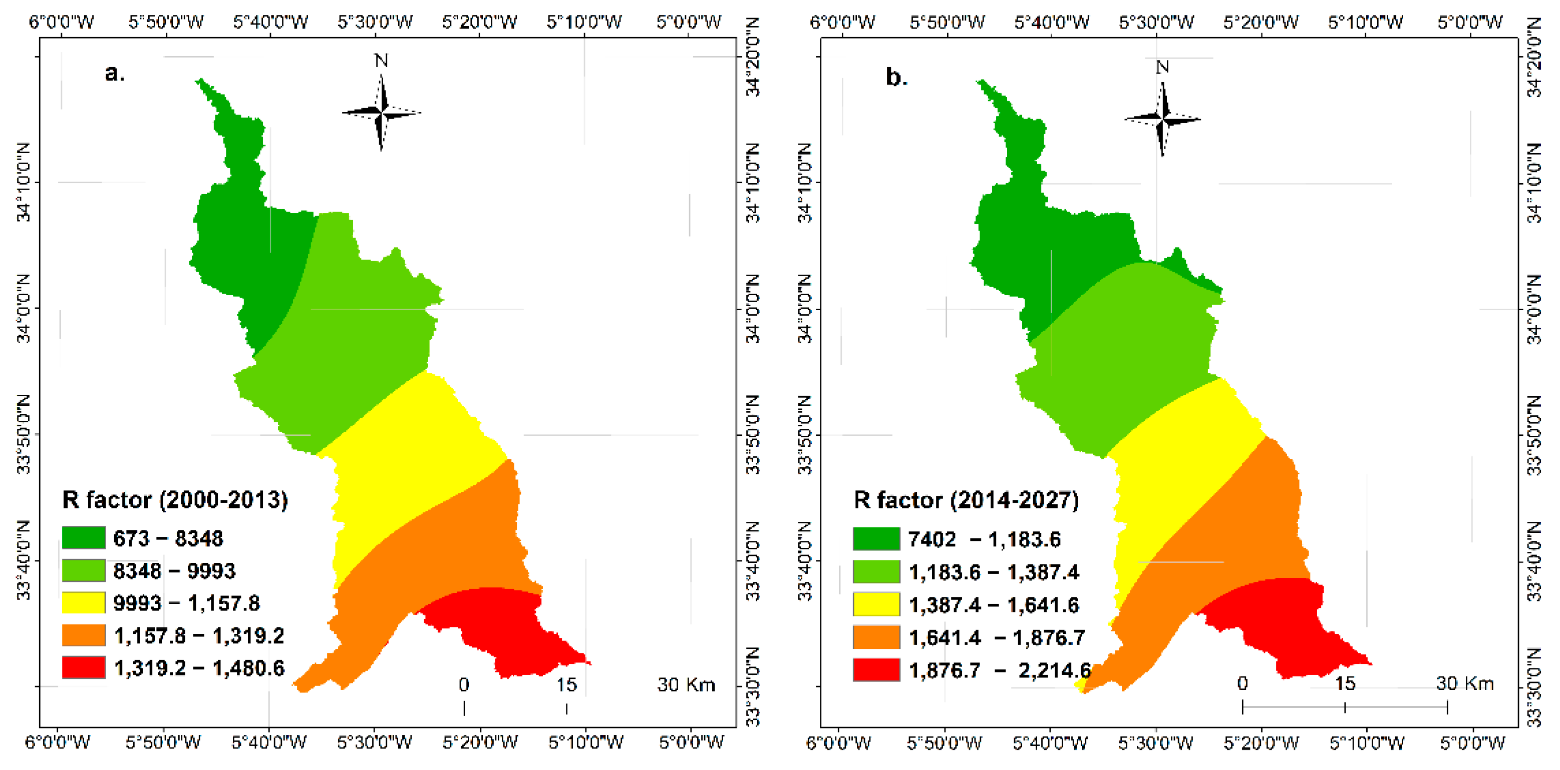
- Rainfall and Runoff erosivity factor (R)
- E: kinetic energy of rains (MJ/ha)
- I30: maximum rainfall intensity in 30 min mm/h
- I: rain intensity
- R is the rainfall-runoff erosivity factor (MJ mm ha−1 h −1 y−1)
- P is the average annual rainfall (mm)
- B.
- Soil erodibility factor (K)
- C.
- Slope Length and Steepness factor (LS)
- D.
- Cover management factor (C)
- E.
- Support practice factor (P)
2.3.2. SWAT Model
- SWt is the final soil water content (mm),
- SW0 is the initial soil water content (mm),
- t is the time (days),
- Rday is the amount of precipitation on day i (mm),
- Qsurf is the amount of surface runoff on day i (mm),
- Ea is the amount of evapotranspiration on day i (mm),
- Wseep is the amount of water entering the vadose zone from the soil profile on day i (mm),
- Qlat is the amount of return flow on day i (mm).
- Sed is the sediment yield on a given day (tons),
- Qsurf is the surface runof volume (mm H2O/ha),
- qpeak is the peak runof rate (m3 /s),
- Areahru is the area of the HRU (ha),
- KUSLE is the soil erodability factor
- CUSLE is the cover and management factor,
- PUSLE is the support practice factor,
- LSUSLE is the topographic factor and CFRG is the coarse fragment factor
2.3.3. Spatial Autocorrelation Analysis
3. Results and Discussion
3.1. Stream Flow
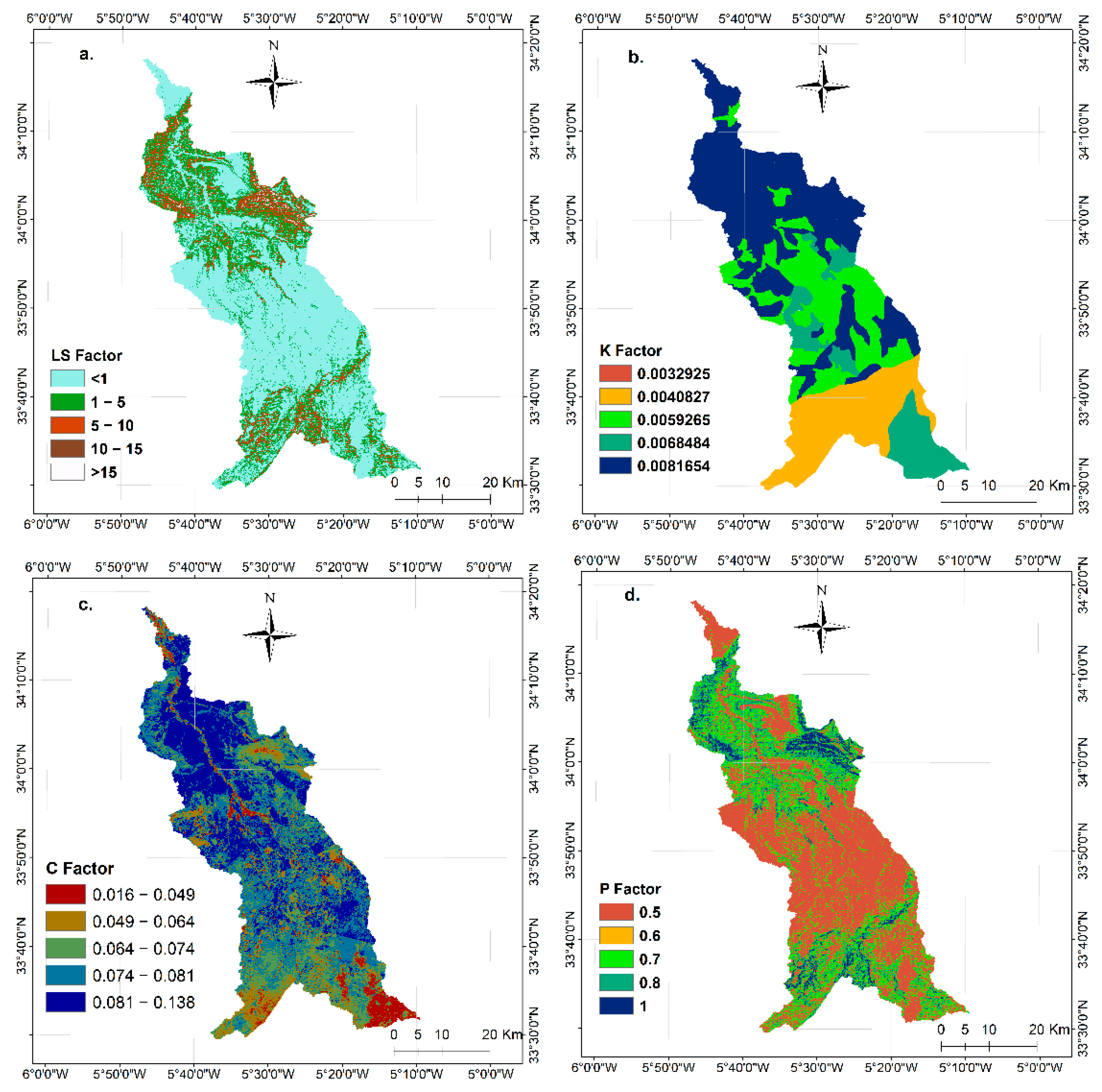
3.2. Factors Maps Analysis
3.3. Spatial Distribution of Soil Erosion Rate
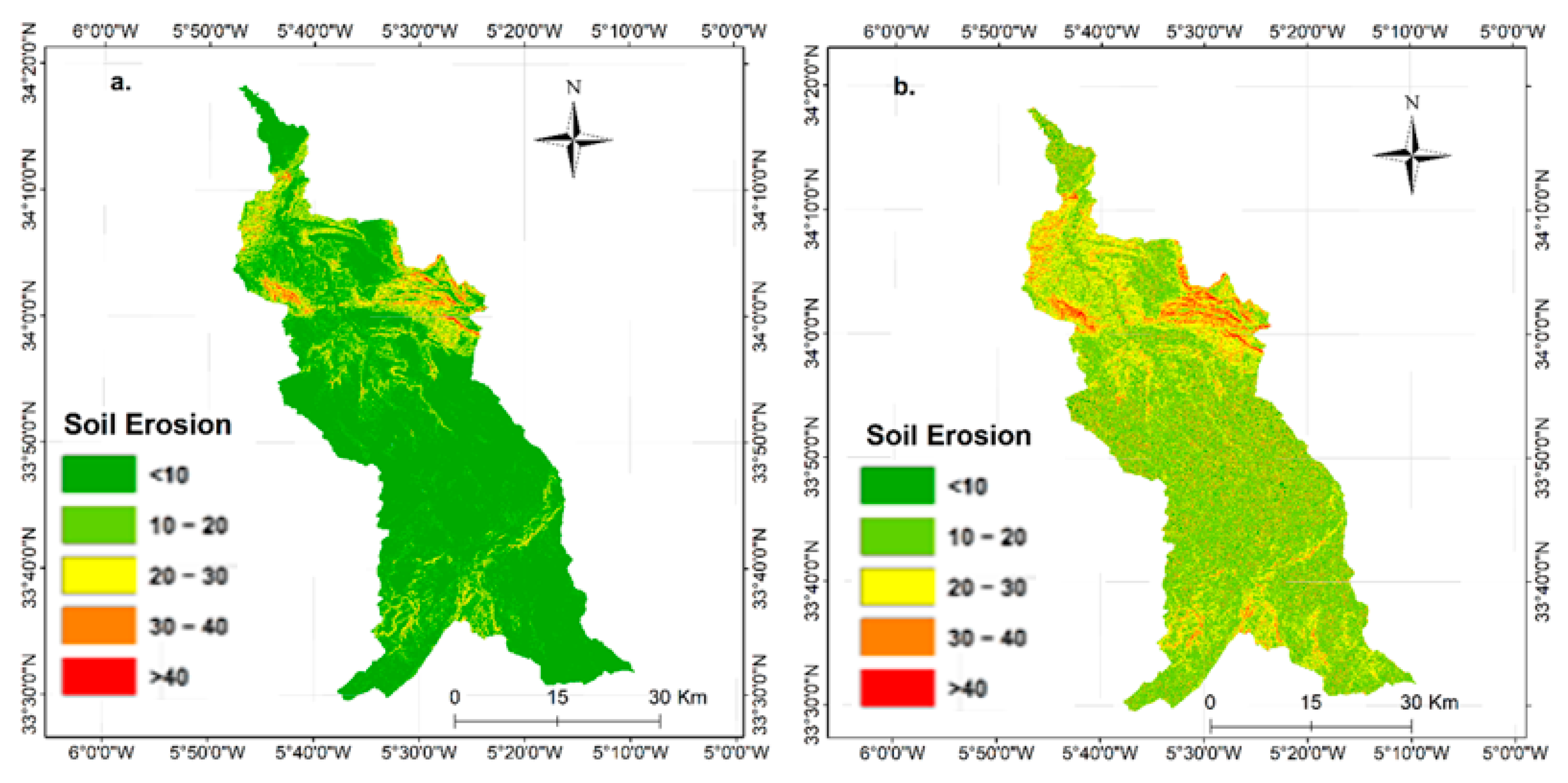
3.3.1. Soil Erosion Rate Using RUSLE Method
3.3.2. Soil Erosion Rate Using SWAT Model
3.4. Soil Erosion Rate in Relation to Land Use
3.5. Spatial Autocorrelation of Soil Erosion Rate
4. Conclusions
- -
- Standard calibration statistics were used to assess the performance of SWAT model. Comparison of modeled and observed monthly streamflow datasets resulted from R2, NSE, and PBIAS values of 0.75, 0.70, and −1.1 respectively, which indicated that the hydrological cycle of the R’Dom watershed could be accurately simulated using the SWAT model.
- -
- The erosion rate values vary from 0 to 8 t ha−1 for both periods. For the 2000/2013 period, the RUSLE showed that 71.90% of the total area of the watershed is exposed to a very low erosion, whereas only 0.02% of the area was exposed to a very high erosion, while the SWAT showed that 35.57% is exposed to a very low erosion, whereas only 9% of the area was exposed to a very high erosion. For the period of 2014/2027 it is expected to have a very low erosion risk for a portion of 58.33% and 36.97% of the total area, and a very high risk for 0.27% and 9.24% for RUSLE method and SWAT respectively.
- -
- It was verified that erosion loss was found mainly in agricultural lands (AGRL) with an area of 48.1% and 59.58%, Followed by bare lands (BARR) with 38.27% and 25.26% in RUSLE equation and SWAT model respectively.
Author Contributions
Funding
Institutional Review Board Statement
Informed Consent Statement
Acknowledgments
Conflicts of Interest
References
- Saavedra, C. Estimating Spatial Patterns of Soil Erosion and Deposition in the Andean Region Using Geo-Information Techniques: A Case Study in Cochabamba, Bolivia; ITC Dissertation: Wageningen, the Netherlands, 2005; ISBN 978-90-8504-289-1. [Google Scholar]
- Chuenchum, P.; Xu, M.; Tang, W. Estimation of Soil Erosion and Sediment Yield in the Lancang–Mekong River Using the Modified Revised Universal Soil Loss Equation and GIS Techniques. Water 2019, 12, 135. [Google Scholar] [CrossRef] [Green Version]
- Anees, M.T.; Abdullah, K.; Nawawi, M.N.M.; Norulaini, N.A.N.; Syakir, M.I.; Omar, A.K.M. Soil Erosion Analysis by RUSLE and Sediment Yield Models Using Remote Sensing and GIS in Kelantan State, Peninsular Malaysia. Soil Res. 2018, 56, 356. [Google Scholar] [CrossRef]
- Zhang, Y.; Degroote, J.; Wolter, C.; Sugumaran, R. Integration of Modified Universal Soil Loss Equation (MUSLE) into a Gis Framework to Assess Soil Erosion Risk: Gis Musle Model to Assess Soil Erosion Risk. Land Degrad. Dev. 2009, 20, 84–91. [Google Scholar] [CrossRef] [Green Version]
- Kopittke, P.M.; Menzies, N.W.; Wang, P.; McKenna, B.A.; Lombi, E. Soil and the Intensification of Agriculture for Global Food Security. Environ. Int. 2019, 132, 105078. [Google Scholar] [CrossRef]
- Sartori, M.; Philippidis, G.; Ferrari, E.; Borrelli, P.; Lugato, E.; Montanarella, L.; Panagos, P. A Linkage between the Biophysical and the Economic: Assessing the Global Market Impacts of Soil Erosion. Land Use Policy 2019, 86, 299–312. [Google Scholar] [CrossRef]
- UN (United Nations). Draft Resolution Submitted by the Vice-Chair of the Committee, Ms. Farrah Brown (Jamaica), on the Basis of Informal Consultations on Draft Resolution A/C.2/68/L.21; United Nations General Assembly: Washington, DC, USA, 2013. [Google Scholar]
- Tóth, G.; Hermann, T.; da Silva, M.R.; Montanarella, L. Monitoring Soil for Sustainable Development and Land Degradation Neutrality. Environ. Monit. Assess. 2018, 190, 57. [Google Scholar] [CrossRef] [Green Version]
- Cramer, W.; Guiot, J.; Fader, M.; Garrabou, J.; Gattuso, J.-P.; Iglesias, A.; Lange, M.A.; Lionello, P.; Llasat, M.C.; Paz, S.; et al. Climate Change and Interconnected Risks to Sustainable Development in the Mediterranean. Nat. Clim. Chang. 2018, 8, 972–980. [Google Scholar] [CrossRef] [Green Version]
- Knippertz, P.; Christoph, M.; Speth, P. Long-Term Precipitation Variability in Morocco and the Link to the Large-Scale Circulation in Recent and Future Climates. Meteorol. Atmos. Phys. 2003, 83, 67–88. [Google Scholar] [CrossRef]
- García Martinez, M.; Poole, N. The Development of Private Fresh Produce Safety Standards: Implications for Developing Mediterranean Exporting Countries. Food Policy 2004, 29, 229–255. [Google Scholar] [CrossRef] [Green Version]
- Abdelwahab, O.M.M.; Ricci, G.F.; De Girolamo, A.M.; Gentile, F. Modelling Soil Erosion in a Mediterranean Watershed: Comparison between SWAT and AnnAGNPS Models. Environ. Res. 2018, 166, 363–376. [Google Scholar] [CrossRef]
- Shen, Z.Y.; Gong, Y.W.; Li, Y.H.; Hong, Q.; Xu, L.; Liu, R.M. A Comparison of WEPP and SWAT for Modeling Soil Erosion of the Zhangjiachong Watershed in the Three Gorges Reservoir Area. Agric. Water Manag. 2009, 96, 1435–1442. [Google Scholar] [CrossRef]
- Pham, T.G.; Degener, J.; Kappas, M. Integrated Universal Soil Loss Equation (USLE) and Geographical Information System (GIS) for Soil Erosion Estimation in A Sap Basin: Central Vietnam. Int. Soil Water Conserv. Res. 2018, 6, 99–110. [Google Scholar] [CrossRef]
- Park, S.; Oh, C.; Jeon, S.; Jung, H.; Choi, C. Soil Erosion Risk in Korean Watersheds, Assessed Using the Revised Universal Soil Loss Equation. J. Hydrol. 2011, 399, 263–273. [Google Scholar] [CrossRef]
- Fortuño Ibáñez, J.; Gómez Valentín, M.; Jang, D. Application of the KINEROS 2 Model to Natural Basin for Estimation of Erosion. Appl. Sci. 2021, 11, 9320. [Google Scholar] [CrossRef]
- Berteni, F.; Grossi, G. Water Soil Erosion Evaluation in a Small Alpine Catchment Located in Northern Italy: Potential Effects of Climate Change. Geosciences 2020, 10, 386. [Google Scholar] [CrossRef]
- Thomas, K.; Chen, W.; Lin, B.-S.; Seeboonruang, U. Evaluation of the SEdiment Delivery Distributed (SEDD) Model in the Shihmen Reservoir Watershed. Sustainability 2020, 12, 6221. [Google Scholar] [CrossRef]
- Ouyang, W.; Hao, F.; Skidmore, A.K.; Toxopeus, A.G. Soil Erosion and Sediment Yield and Their Relationships with Vegetation Cover in Upper Stream of the Yellow River. Sci. Total Environ. 2010, 409, 396–403. [Google Scholar] [CrossRef]
- Baigorria, G.A.; Romero, C.C. Assessment of Erosion Hotspots in a Watershed: Integrating the WEPP Model and GIS in a Case Study in the Peruvian Andes. Environ. Model. Softw. 2007, 22, 1175–1183. [Google Scholar] [CrossRef]
- Haregeweyn, N.; Yohannes, F. Testing and Evaluation of the Agricultural Non-Point Source Pollution Model (AGNPS) on Augucho Catchment, Western Hararghe, Ethiopia. Agric. Ecosyst. Environ. 2003, 99, 201–212. [Google Scholar] [CrossRef]
- Beasley, D.B.; Huggins, L.F.; Monke, E.J. ANSWERS: A Model for Watershed Planning. Trans. ASAE 1980, 23, 0938–0944. [Google Scholar] [CrossRef]
- Grum, B.; Woldearegay, K.; Hessel, R.; Baartman, J.E.M.; Abdulkadir, M.; Yazew, E.; Kessler, A.; Ritsema, C.J.; Geissen, V. Assessing the Effect of Water Harvesting Techniques on Event-Based Hydrological Responses and Sediment Yield at a Catchment Scale in Northern Ethiopia Using the Limburg Soil Erosion Model (LISEM). Catena 2017, 159, 20–34. [Google Scholar] [CrossRef]
- Veihe, A.; Rey, J.; Quinton, J.N.; Strauss, P.; Sancho, F.M.; Somarriba, M. Modelling of Event-Based Soil Erosion in Costa Rica, Nicaragua and Mexico: Evaluation of the EUROSEM Model. Catena 2001, 44, 187–203. [Google Scholar] [CrossRef] [Green Version]
- de Jong, S.M.; Paracchini, M.L.; Bertolo, F.; Folving, S.; Megier, J.; de Roo, A.P.J. Regional Assessment of Soil Erosion Using the Distributed Model SEMMED and Remotely Sensed Data. Catena 1999, 37, 291–308. [Google Scholar] [CrossRef]
- Williams, J.R.; Nicks, A.D.; Arnold, J.G. Simulator for Water Resources in Rural Basins. J. Hydraul. Eng. 1985, 111, 970–986. [Google Scholar] [CrossRef]
- Morgan, R.P.C. A Simple Approach to Soil Loss Prediction: A Revised Morgan–Morgan–Finney Model. Catena 2001, 44, 305–322. [Google Scholar] [CrossRef]
- Wang, H.; Wu, Z.; Hu, C. A Comprehensive Study of the Effect of Input Data on Hydrology and Non-Point Source Pollution Modeling. Water Resour. Manag. 2015, 29, 1505–1521. [Google Scholar] [CrossRef]
- Hajigholizadeh, M.; Melesse, A.; Fuentes, H. Erosion and Sediment Transport Modelling in Shallow Waters: A Review on Approaches, Models and Applications. Int. J. Environ. Res. Public Health 2018, 15, 518. [Google Scholar] [CrossRef] [Green Version]
- Brzezińska, M.; Szatten, D.; Babiński, Z. Prediction of Erosion-Prone Areas in the Catchments of Big Lowland Rivers: Implementation of Maximum Entropy Modelling—Using the Example of the Lower Vistula River (Poland). Remote Sens. 2021, 13, 4775. [Google Scholar] [CrossRef]
- Arabameri, A.; Tiefenbacher, J.P.; Blaschke, T.; Pradhan, B.; Tien Bui, D. Morphometric Analysis for Soil Erosion Susceptibility Mapping Using Novel GIS-Based Ensemble Model. Remote Sens. 2020, 12, 874. [Google Scholar] [CrossRef] [Green Version]
- Zaimes, G.N.; Schultz, R.C. Assessing Riparian Conservation Land Management Practice Impacts on Gully Erosion in Iowa. Environ. Manag. 2012, 49, 1009–1021. [Google Scholar] [CrossRef] [PubMed]
- Rahmati, O.; Haghizadeh, A.; Pourghasemi, H.R.; Noormohamadi, F. Gully Erosion Susceptibility Mapping: The Role of GIS-Based Bivariate Statistical Models and Their Comparison. Nat. Hazards 2016, 82, 1231–1258. [Google Scholar] [CrossRef]
- Conoscenti, C.; Angileri, S.; Cappadonia, C.; Rotigliano, E.; Agnesi, V.; Märker, M. Gully Erosion Susceptibility Assessment by Means of GIS-Based Logistic Regression: A Case of Sicily (Italy). Geomorphology 2014, 204, 399–411. [Google Scholar] [CrossRef] [Green Version]
- Gómez-Gutiérrez, Á.; Conoscenti, C.; Angileri, S.E.; Rotigliano, E.; Schnabel, S. Using Topographical Attributes to Evaluate Gully Erosion Proneness (Susceptibility) in Two Mediterranean Basins: Advantages and Limitations. Nat. Hazards 2015, 79, 291–314. [Google Scholar] [CrossRef]
- Rafiei, V.; Ghahramani, A.; An-Vo, D.-A.; Mushtaq, S. Modelling Hydrological Processes and Identifying Soil Erosion Sources in a Tropical Catchment of the Great Barrier Reef Using SWAT. Water 2020, 12, 2179. [Google Scholar] [CrossRef]
- Boufala, M.; El Hmaidi, A.; Chadli, K.; Essahlaoui, A.; El Ouali, A.; Taia, S. Hydrological Modeling of Water and Soil Resources in the Basin Upstream of the Allal El Fassi Dam (Upper Sebou Watershed, Morocco). Model. Earth Syst. Environ. 2019, 5, 1163–1177. [Google Scholar] [CrossRef]
- Boufala, M.; El Hmaidf, A.; Chadli, K.; Essahlaoui, A.; El Ouali, A.; Lahjouj, A. Assessment of the Risk of Soil Erosion Using RUSLE Method and SWAT Model at the M’dez Watershed, Middle Atlas, Morocco. E3S Web Conf. 2020, 150, 03014. [Google Scholar] [CrossRef]
- Chadli, K. Estimation of Soil Loss Using RUSLE Model for Sebou Watershed (Morocco). Model. Earth Syst. Environ. 2016, 2, 51. [Google Scholar] [CrossRef] [Green Version]
- Williams, J.R.; Agricultural Research Service, U.S. Present and Prospective Technology for Predicting Sediment Yield and Sources; Agricultural Research Service, U.S. Department of Agriculture: Honolulu, HI, USA, 1975.
- Chawanda, C.J.; Arnold, J.; Thiery, W.; van Griensven, A. Mass Balance Calibration and Reservoir Representations for Large-Scale Hydrological Impact Studies Using SWAT+. Clim. Chang. 2020, 163, 1307–1327. [Google Scholar] [CrossRef]
- Mohajane, M.; Costache, R.; Karimi, F.; Bao Pham, Q.; Essahlaoui, A.; Nguyen, H.; Laneve, G.; Oudija, F. Application of Remote Sensing and Machine Learning Algorithms for Forest Fire Mapping in a Mediterranean Area. Ecol. Indic. 2021, 129, 107869. [Google Scholar] [CrossRef]
- Duarte, L.; Teodoro, A.C.; Gonçalves, J.A.; Soares, D.; Cunha, M. Assessing Soil Erosion Risk Using RUSLE through a GIS Open Source Desktop and Web Application. Environ. Monit. Assess. 2016, 188, 351. [Google Scholar] [CrossRef] [PubMed]
- Zepner, L.; Karrasch, P.; Wiemann, F.; Bernard, L. ClimateCharts.Net—An Interactive Climate Analysis Web Platform. Int. J. Digit. Earth 2021, 14, 338–356. [Google Scholar] [CrossRef]
- Essahlaoui, A.; Ouali, E.A. Détermination de la structure géologique de la partie Sud de la plaine du Saïss (bassin de Meknès-Fès, Maroc) par la méthode géoélectrique. Bull. Eng. Geol. Environ. 2003, 62, 155–166. [Google Scholar] [CrossRef]
- Brouziyne, Y.; Abouabdillah, A.; Bouabid, R.; Benaabidate, L.; Oueslati, O. SWAT Manual Calibration and Parameters Sensitivity Analysis in a Semi-Arid Watershed in North-Western Morocco. Arab. J. Geosci. 2017, 10, 427. [Google Scholar] [CrossRef]
- Copernicus Open Access Hub. Available online: https://scihub.copernicus.eu/dhus/#/home (accessed on 13 November 2021).
- Congedo, L. Semi-Automatic Classification Plugin Documentation. Release 2016, 4, 29. [Google Scholar] [CrossRef]
- Chavez, P.S. An Improved Dark-Object Subtraction Technique for Atmospheric Scattering Correction of Multispectral Data. Remote Sens. Environ. 1988, 24, 459–479. [Google Scholar] [CrossRef]
- Mohajane, M.; Essahlaoui, A.; Oudija, F.; El Hafyani, M.; Cláudia Teodoro, A. Mapping Forest Species in the Central Middle Atlas of Morocco (Azrou Forest) through Remote Sensing Techniques. ISPRS Int. J. Geo-Inf. 2017, 6, 275. [Google Scholar] [CrossRef] [Green Version]
- EarthExplorer. Available online: https://earthexplorer.usgs.gov/ (accessed on 13 November 2021).
- Chakilu, G.G.; Sándor, S.; Zoltán, T. Change in Stream Flow of Gumara Watershed, Upper Blue Nile Basin, Ethiopia under Representative Concentration Pathway Climate Change Scenarios. Water 2020, 12, 3046. [Google Scholar] [CrossRef]
- Chen, Y.; Nakatsugawa, M.; Ohashi, H. Research of Impacts of the 2018 Hokkaido Eastern Iburi Earthquake on Sediment Transport in the Atsuma River Basin Using the SWAT Model. Water 2021, 13, 356. [Google Scholar] [CrossRef]
- Zhang, H.; Yang, Q.; Li, R.; Liu, Q.; Moore, D.; He, P.; Ritsema, C.J.; Geissen, V. Extension of a GIS Procedure for Calculating the RUSLE Equation LS Factor. Comput. Geosci. 2013, 52, 177–188. [Google Scholar] [CrossRef]
- Tessema, Y.M.; Jasińska, J.; Yadeta, L.T.; Świtoniak, M.; Puchałka, R.; Gebregeorgis, E.G. Soil Loss Estimation for Conservation Planning in the Welmel Watershed of the Genale Dawa Basin, Ethiopia. Agronomy 2020, 10, 777. [Google Scholar] [CrossRef]
- Wischmeier, W.H.; Smith, D.D. Predicting Rainfall Erosion Losses: A Guide to Conservation Planning; Department of Agriculture, Science and Education Administration: Corvallis, OR, USA, 1978. [Google Scholar]
- Beguería, S.; Serrano-Notivoli, R.; Tomas-Burguera, M. Computation of Rainfall Erosivity from Daily Precipitation Amounts. Sci. Total Environ. 2018, 637–638, 359–373. [Google Scholar] [CrossRef]
- Petroselli, A.; Apollonio, C.; De Luca, D.L.; Salvaneschi, P.; Pecci, M.; Marras, T.; Schirone, B. Comparative Evaluation of the Rainfall Erosivity in the Rieti Province, Central Italy, Using Empirical Formulas and a Stochastic Rainfall Generator. Hydrology 2021, 8, 171. [Google Scholar] [CrossRef]
- Gourfi, A.; Daoudi, L.; Shi, Z. The Assessment of Soil Erosion Risk, Sediment Yield and Their Controlling Factors on a Large Scale: Example of Morocco. J. Afr. Earth Sci. 2018, 147, 281–299. [Google Scholar] [CrossRef]
- CPCS (Commission de Pédologie et de Cartographie des Sols). Classification Des Sols. Grognon, France: Laboratoire de Géologie et de Pédologie Ecole Nationale Supérieure d’Agronomie. Available online: https://scholar.google.com/scholar_lookup?title=Classification%20des%20sols.%20Grognon%2C%20France%20%3A%20Laboratoire%20de%20G%C3%A9ologie%20et%20de%20P%C3%A9dologie&publication_year=1967&author=CPCS%20(Commission%20de%20P%C3%A9dologie%20et%20de%20Cartographie%20des%20Sols) (accessed on 9 December 2021).
- De Jong, S.M. Derivation of Vegetative Variables from a Landsat Tm Image for Modelling Soil Erosion. Earth Surf. Process. Landf. 1994, 19, 165–178. [Google Scholar] [CrossRef]
- Das, S.; Deb, P.; Bora, P.K.; Katre, P. Comparison of RUSLE and MMF Soil Loss Models and Evaluation of Catchment Scale Best Management Practices for a Mountainous Watershed in India. Sustainability 2020, 13, 232. [Google Scholar] [CrossRef]
- Tucker, C.J. Red and Photographic Infrared Linear Combinations for Monitoring Vegetation. Remote Sens. Environ. 1979, 8, 127–150. [Google Scholar] [CrossRef] [Green Version]
- Aga, A.; Chane, B.; Melesse, A. Soil Erosion Modelling and Risk Assessment in Data Scarce Rift Valley Lake Regions, Ethiopia. Water 2018, 10, 1684. [Google Scholar] [CrossRef] [Green Version]
- Mahara, G.; Wang, C.; Yang, K.; Chen, S.; Guo, J.; Gao, Q.; Wang, W.; Wang, Q.; Guo, X. The Association between Environmental Factors and Scarlet Fever Incidence in Beijing Region: Using GIS and Spatial Regression Models. Int. J. Environ. Res. Public. Health 2016, 13, 1083. [Google Scholar] [CrossRef]
- Luo, L.; Jiang, J.; Zhang, G.; Wang, L.; Wang, Z.; Yang, J.; Yu, C. Stroke Mortality Attributable to Ambient Particulate Matter Pollution from 1990 to 2015 in China: An Age-Period-Cohort and Spatial Autocorrelation Analysis. Int. J. Environ. Res. Public Health 2017, 14, 772. [Google Scholar] [CrossRef]
- Meliho, M.; Khattabi, A.; Mhammdi, N. Spatial Assessment of Soil Erosion Risk by Integrating Remote Sensing and GIS Techniques: A Case of Tensift Watershed in Morocco. Environ. Earth Sci. 2020, 79, 207. [Google Scholar] [CrossRef]
- Wang, R.; Zhang, S.; Yang, J.; Pu, L.; Yang, C.; Yu, L.; Chang, L.; Bu, K. Integrated Use of GCM, RS, and GIS for the Assessment of Hillslope and Gully Erosion in the Mushi River Sub-Catchment, Northeast China. Sustainability 2016, 8, 317. [Google Scholar] [CrossRef]
- Meliho, M.; Khattabi, A.; Mhammdi, N. A GIS-Based Approach for Gully Erosion Susceptibility Modelling Using Bivariate Statistics Methods in the Ourika Watershed, Morocco. Environ. Earth Sci. 2018, 77, 655. [Google Scholar] [CrossRef]
- Sadiki, A.; Faleh, A.; Zezerze, J.L.; Mastass, H. Quantifcation de l’erosion En Nappe Dans Le Bassin Versant de l’Oued Sahla, Rif Occidental Maroc. Cah. Géogr. 2009, 6, 59–70. [Google Scholar]
- Tahiri, M.; Tabyaoui, H.; Tahiri, A.; Hadi, H.E.; Hammichi, F.E.; Achab, M. Modelling Soil Erosion and Sedimentation in the Oued Haricha Sub-Basin (Tahaddart Watershed, Western Rif, Morocco): Risk Assessment. J. Geosci. Environ. Prot. 2016, 4, 107–119. [Google Scholar] [CrossRef] [Green Version]


| 2000/2013 | 2014/2027 | |||||
|---|---|---|---|---|---|---|
| Station Name | Coordinate (m) | Average Rainfall | R | Average Rainfall | R | |
| X | Y | |||||
| P3401 | 237,745 | 3,772,098 | 395.30 | 732.82 | 497.69 | 1061.82 |
| P6170 | 234,726 | 3,726,750 | 488.72 | 1031.18 | 543.69 | 1224.24 |
| P6405 | 301,106 | 3,741,223 | 529.02 | 1171.49 | 695.13 | 1818.33 |
| P6769 | 283,324 | 3,775,316 | 467.92 | 961.44 | 501.92 | 1076.38 |
| P6924 | 285,738 | 3,705,901 | 615.66 | 1495.50 | 792.65 | 2246.3 |
| P7188 | 242,214 | 3,802,127 | 373.58 | 669.09 | 390.67 | 719.06 |
| Soil Type | Sand (%) (0.05–2 mm) | Silt (%) (0.02–0.05 mm) | Clay (%) (<0.02 mm) | Organic Matter (%) | K-Factor |
|---|---|---|---|---|---|
| Calcimagnesic Soils | 7.3 | 37.7 | 55 | 2.16 | 0.031 |
| Isohumic Soils | 55.7 | 21.1 | 24 | 1.07 | 0.062 |
| Raw Mineral Soils | 8.8 | 34.5 | 56.1 | 2.62 | 0.025 |
| Vertisols | 53.8 | 19.3 | 27.1 | 1.62 | 0.052 |
| Poorly developed Soils | 63.7 | 20.8 | 15.5 | 2.51 | 0.062 |
| Fersiallitic Soils | 18.6 | 36.2 | 45.2 | 1.63 | 0.045 |
| Land Use Class | Slope (%) | P Factor Values |
|---|---|---|
| Agricultural area | 0–4 | 0.5 |
| 4–12 | 0.6 | |
| 12–20 | 0.7 | |
| 20–25 | 0.8 | |
| >52 | 0.9 | |
| Other land | All | 1.0 |
| WATER | FRST | RNGE | WETN | AGRL | BARR | URHD | UIDU | User Accuracy | |
|---|---|---|---|---|---|---|---|---|---|
| WATER | 127 | 2 | 1 | 23 | 2 | 0 | 0 | 0 | 81.93 |
| FRST | 1 | 230 | 13 | 8 | 2 | 1 | 8 | 2 | 86.79 |
| RNGE | 0 | 35 | 159 | 3 | 19 | 2 | 0 | 8 | 70.35 |
| WETN | 8 | 0 | 2 | 56 | 0 | 0 | 2 | 82.35 | |
| AGRL | 1 | 6 | 0 | 0 | 72 | 7 | 4 | 2 | 78.26 |
| BARR | 2 | 0 | 0 | 0 | 1 | 66 | 3 | 9 | 81.48 |
| URHD | 5 | 0 | 0 | 0 | 0 | 0 | 276 | 11 | 94.52 |
| UIDU | 2 | 7 | 0 | 3 | 5 | 18 | 26 | 54 | 46.95 |
| Producer Accuracy | 86.98 | 82.14 | 90.85 | 60.21 | 71.28 | 70.21 | 86.52 | 62.79 | OA = 0.80% Kappa index = 76.8 |
| 2000–2013 | 2014–2027 | |||
|---|---|---|---|---|
| Soil Erosion Severity Class | Soil Loss (t ha−1) | Area (%) | Soil Loss (t ha−1) | Area (%) |
| Very low | <10 | 71.90 | <10 | 58.33 |
| Low | 10–20 | 20.20 | 10–20 | 27.71 |
| Moderate | 20–30 | 6.25 | 20–30 | 11.94 |
| High | 30–40 | 1.42 | 30–40 | 1.73 |
| Very high | >40 | 0.20 | >40 | 0.27 |
| 2000–2013 | 2014–2027 | |||
|---|---|---|---|---|
| Soil Erosion Severity Class | Soil Loss (t ha−1) | Area (%) | Soil Loss (t ha−1) | Area (%) |
| Very low | <10 | 35.57 | 0–10 | 36.97 |
| Low | 10–20 | 28.28 | 10–20 | 25.22 |
| Moderate | 20–30 | 18.45 | 20–30 | 18.35 |
| High | 30–40 | 8.7 | 30–40 | 10.21 |
| Very high | >40 | 9.00 | >40 | 9.24 |
| Area (%) | Very Low | Low | Moderate | High | Very High | |
|---|---|---|---|---|---|---|
| Water | 0.15 | 0.09 | 0.36 | 0.17 | 0.10 | 0.00 |
| forest | 8.01 | 7.66 | 5.53 | 8.58 | 10.74 | 7.53 |
| Range-Grasses | 0.1 | 0.19 | 0.14 | 0.13 | 0.06 | 0.00 |
| Wetlands-Non-Forested | 0.00 | 0.00 | 0.00 | 0.00 | 0.00 | 0.00 |
| Agricultural Land-Generic | 48.1 | 67.45 | 61.06 | 48.45 | 35.89 | 27.65 |
| Barren | 38.27 | 15.25 | 26.19 | 38.01 | 50.12 | 61.80 |
| Residential-High Density | 4.83 | 8.83 | 5.90 | 3.85 | 2.55 | 3.01 |
| Industrial | 0.51 | 0.48 | 0.79 | 0.78 | 0.51 | 0.00 |
| Area (%) | Very Low | Low | Moderate | Very High | High | |
|---|---|---|---|---|---|---|
| Water | 0.12 | 0.05 | 0.01 | 0.41 | 0.05 | 0.09 |
| Forest | 7.33 | 4.67 | 14.95 | 3.93 | 5.82 | 7.30 |
| Range-Grasses | 0.06 | 0.11 | 0.04 | 0.15 | 0.01 | 0.01 |
| Wetlands-Non-Forested | 0.00 | 0.00 | 0.00 | 0.00 | 0.00 | 0.00 |
| Agricultural Land-Generic | 59.58 | 75.47 | 68.26 | 66.08 | 56.03 | 32.05 |
| Barren | 25.26 | 11.01 | 8.43 | 19.18 | 34.35 | 53.32 |
| Residential-High Density | 7.30 | 8.39 | 8.01 | 10.09 | 2.90 | 7.03 |
| Industrial | 0.33 | 0.27 | 0.27 | 0.12 | 0.82 | 0.17 |
| Moran’s I | RUSLE Equation | SWAT Model |
|---|---|---|
| Moran’s Index | 0.12 | 0.32 |
| Variance | 0.00 | 0.00 |
| z-score | 125.37 | 731.57 |
| p-value | 0 | 0 |
Publisher’s Note: MDPI stays neutral with regard to jurisdictional claims in published maps and institutional affiliations. |
© 2022 by the authors. Licensee MDPI, Basel, Switzerland. This article is an open access article distributed under the terms and conditions of the Creative Commons Attribution (CC BY) license (https://creativecommons.org/licenses/by/4.0/).
Share and Cite
Alitane, A.; Essahlaoui, A.; El Hafyani, M.; El Hmaidi, A.; El Ouali, A.; Kassou, A.; El Yousfi, Y.; van Griensven, A.; Chawanda, C.J.; Van Rompaey, A. Water Erosion Monitoring and Prediction in Response to the Effects of Climate Change Using RUSLE and SWAT Equations: Case of R’Dom Watershed in Morocco. Land 2022, 11, 93. https://doi.org/10.3390/land11010093
Alitane A, Essahlaoui A, El Hafyani M, El Hmaidi A, El Ouali A, Kassou A, El Yousfi Y, van Griensven A, Chawanda CJ, Van Rompaey A. Water Erosion Monitoring and Prediction in Response to the Effects of Climate Change Using RUSLE and SWAT Equations: Case of R’Dom Watershed in Morocco. Land. 2022; 11(1):93. https://doi.org/10.3390/land11010093
Chicago/Turabian StyleAlitane, Abdennabi, Ali Essahlaoui, Mohammed El Hafyani, Abdellah El Hmaidi, Anas El Ouali, Amina Kassou, Yassine El Yousfi, Ann van Griensven, Celray James Chawanda, and Anton Van Rompaey. 2022. "Water Erosion Monitoring and Prediction in Response to the Effects of Climate Change Using RUSLE and SWAT Equations: Case of R’Dom Watershed in Morocco" Land 11, no. 1: 93. https://doi.org/10.3390/land11010093
APA StyleAlitane, A., Essahlaoui, A., El Hafyani, M., El Hmaidi, A., El Ouali, A., Kassou, A., El Yousfi, Y., van Griensven, A., Chawanda, C. J., & Van Rompaey, A. (2022). Water Erosion Monitoring and Prediction in Response to the Effects of Climate Change Using RUSLE and SWAT Equations: Case of R’Dom Watershed in Morocco. Land, 11(1), 93. https://doi.org/10.3390/land11010093