
Evaluating Local Attractiveness for Tourism and Recreation—A Case Study of the Communes in Brzeski County, Poland


Abstract
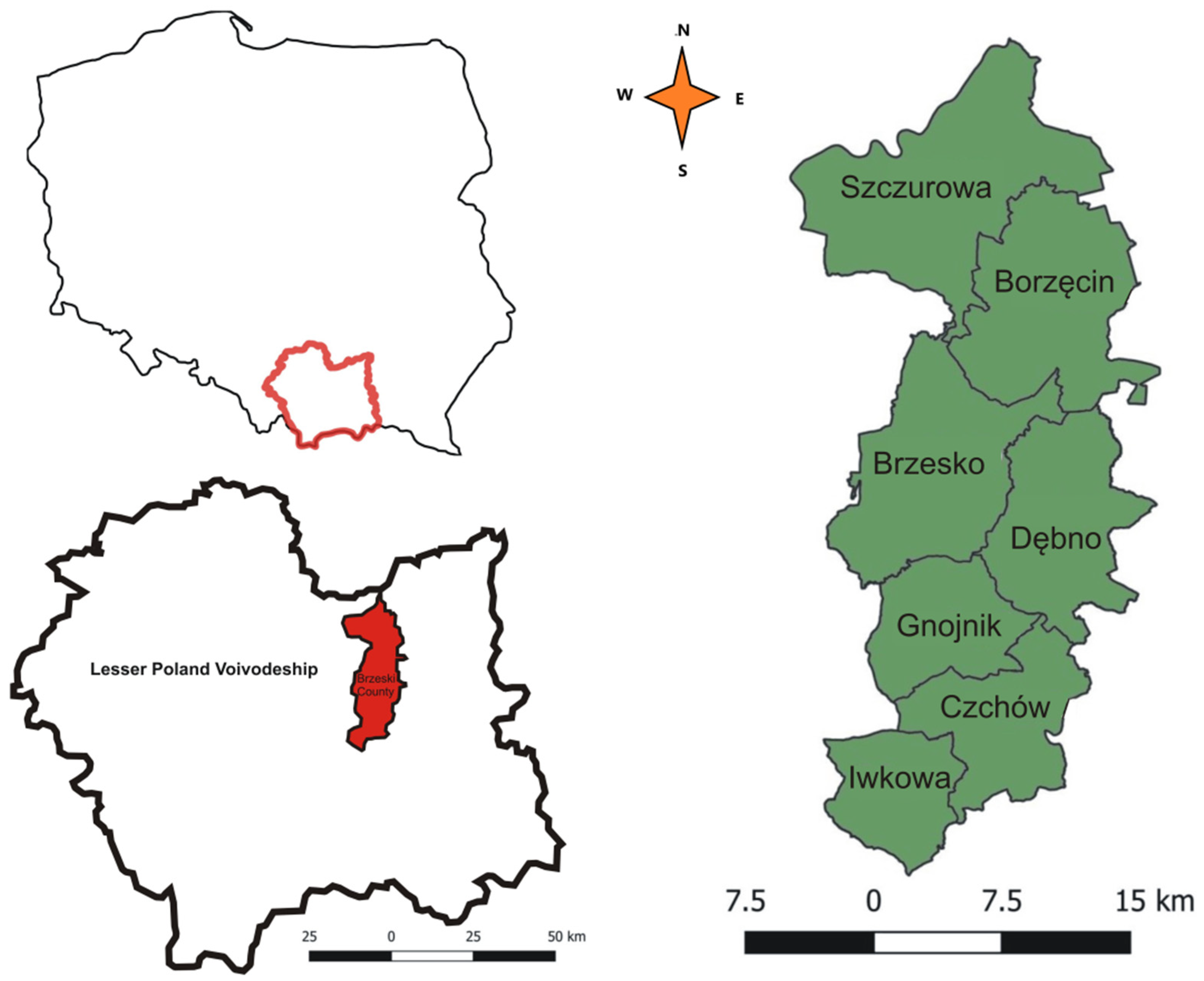
:1. Introduction
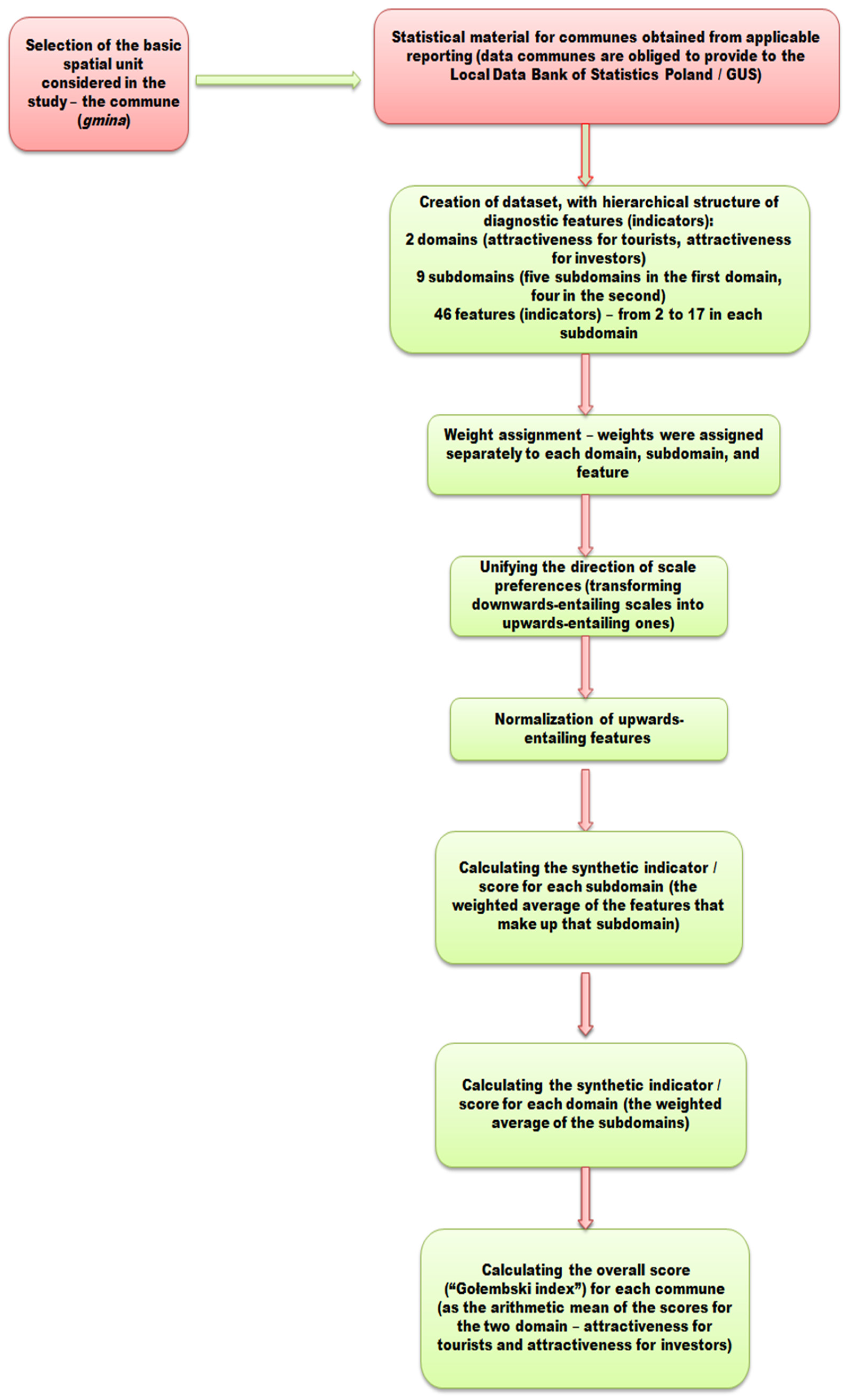
2. Materials and Methods
- The extant tourist attractions;
- The state of the natural environment;
- The environmental protection efforts;
- Transport links;
- The base of accommodation, catering and accompanying facilities.
- The state of service infrastructure;
- The state of technical infrastructure;
- The social relations among society;
- The condition of commune finances (Table 1).
3. Results
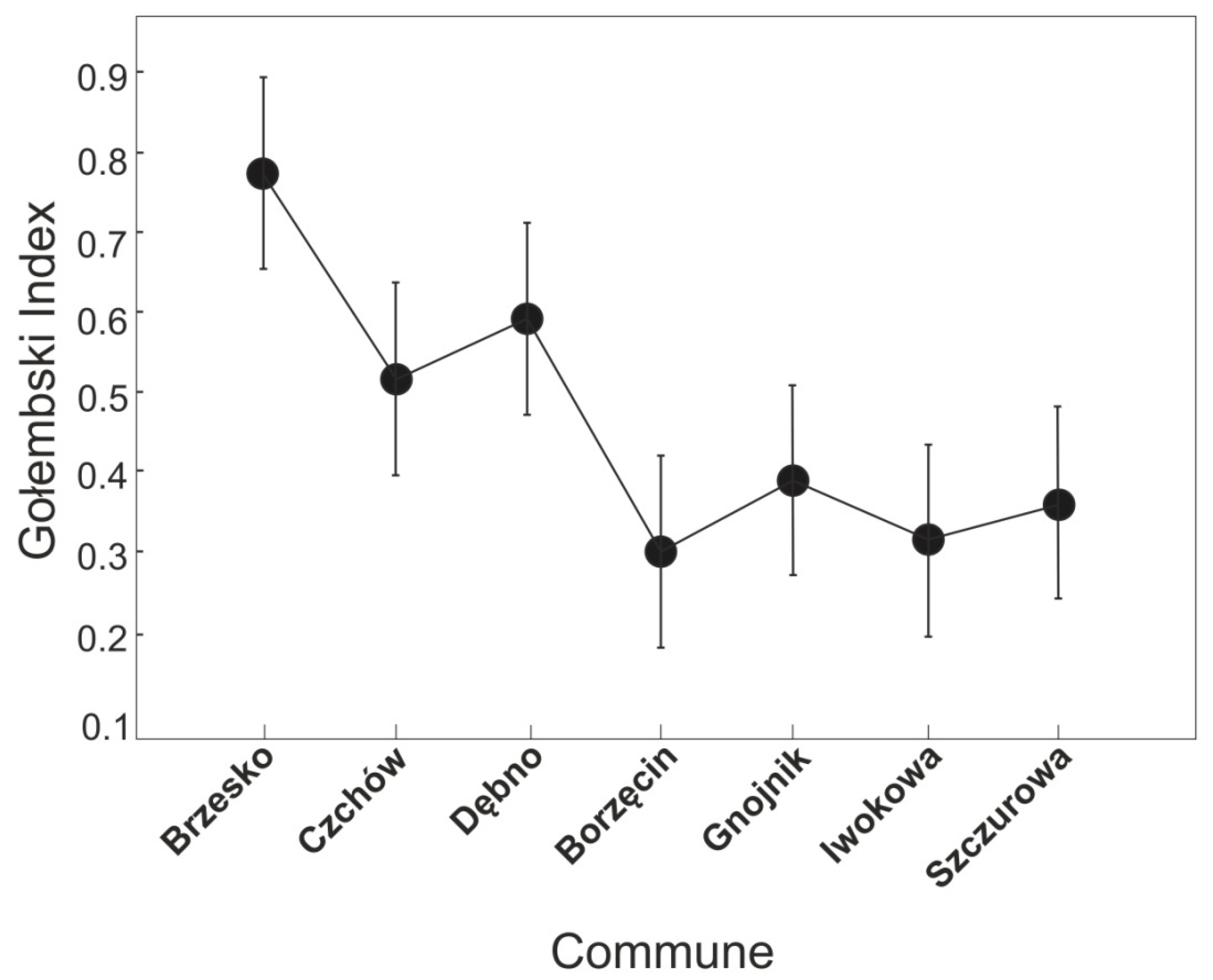
3.1. Tourism Attractiveness Assessment Using Gołembski’s Index
3.1.1. Assessment of Attractiveness for Tourists
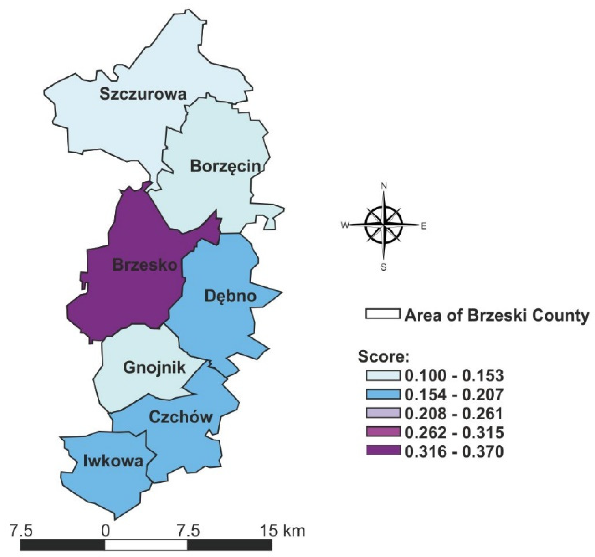
3.1.2. Assessment of Attractiveness for Investors
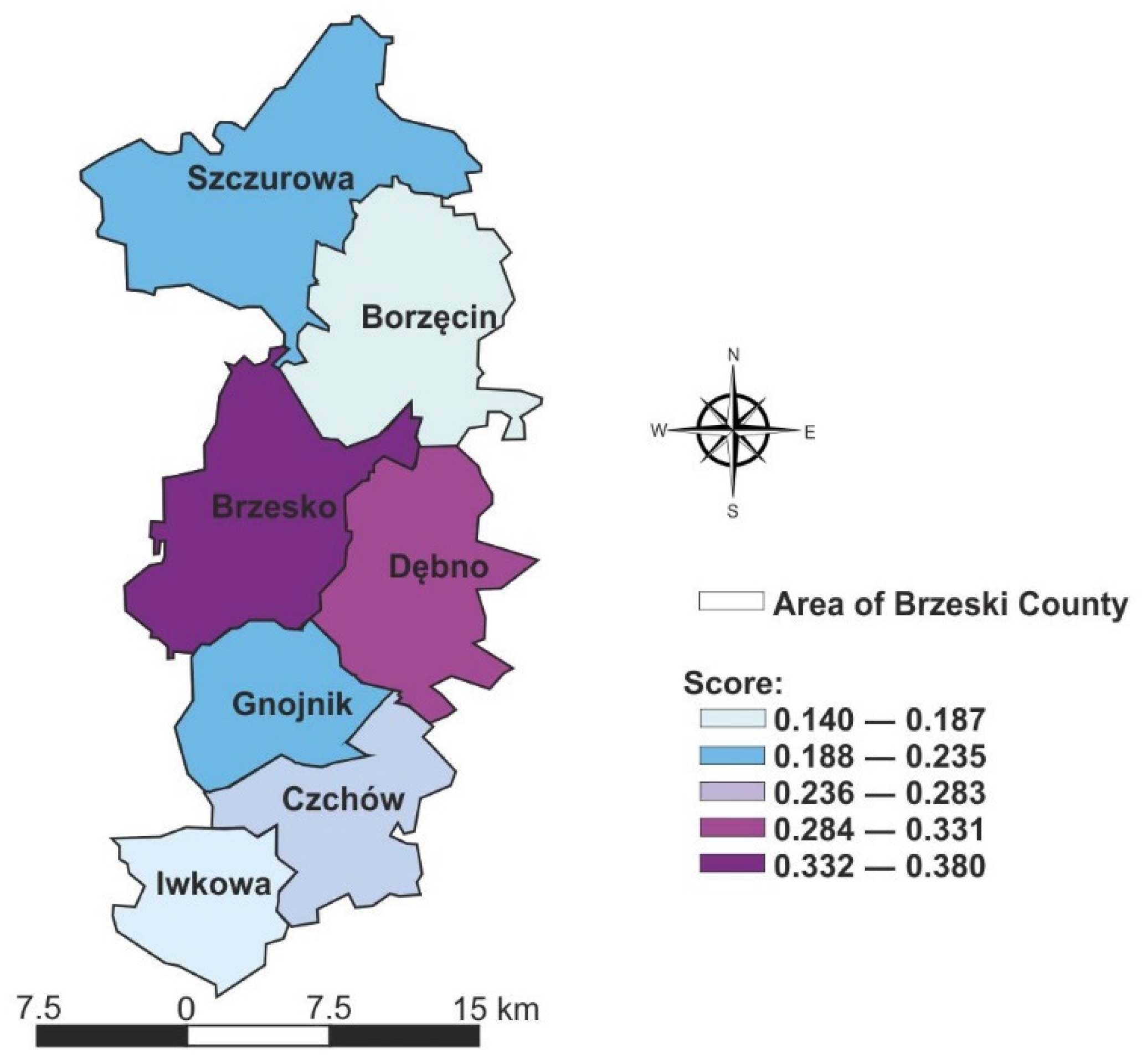
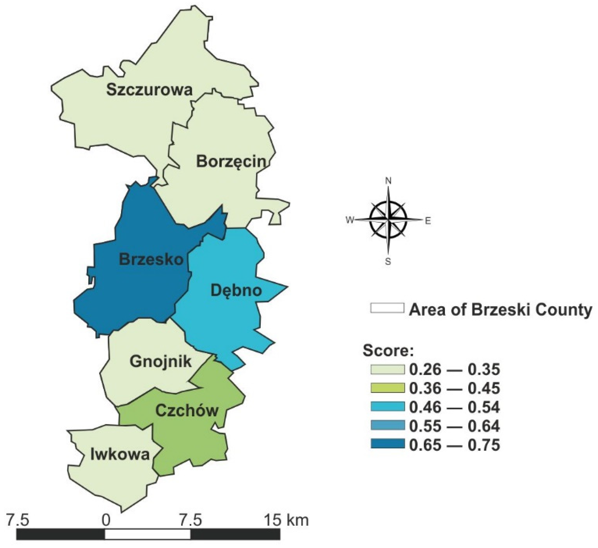
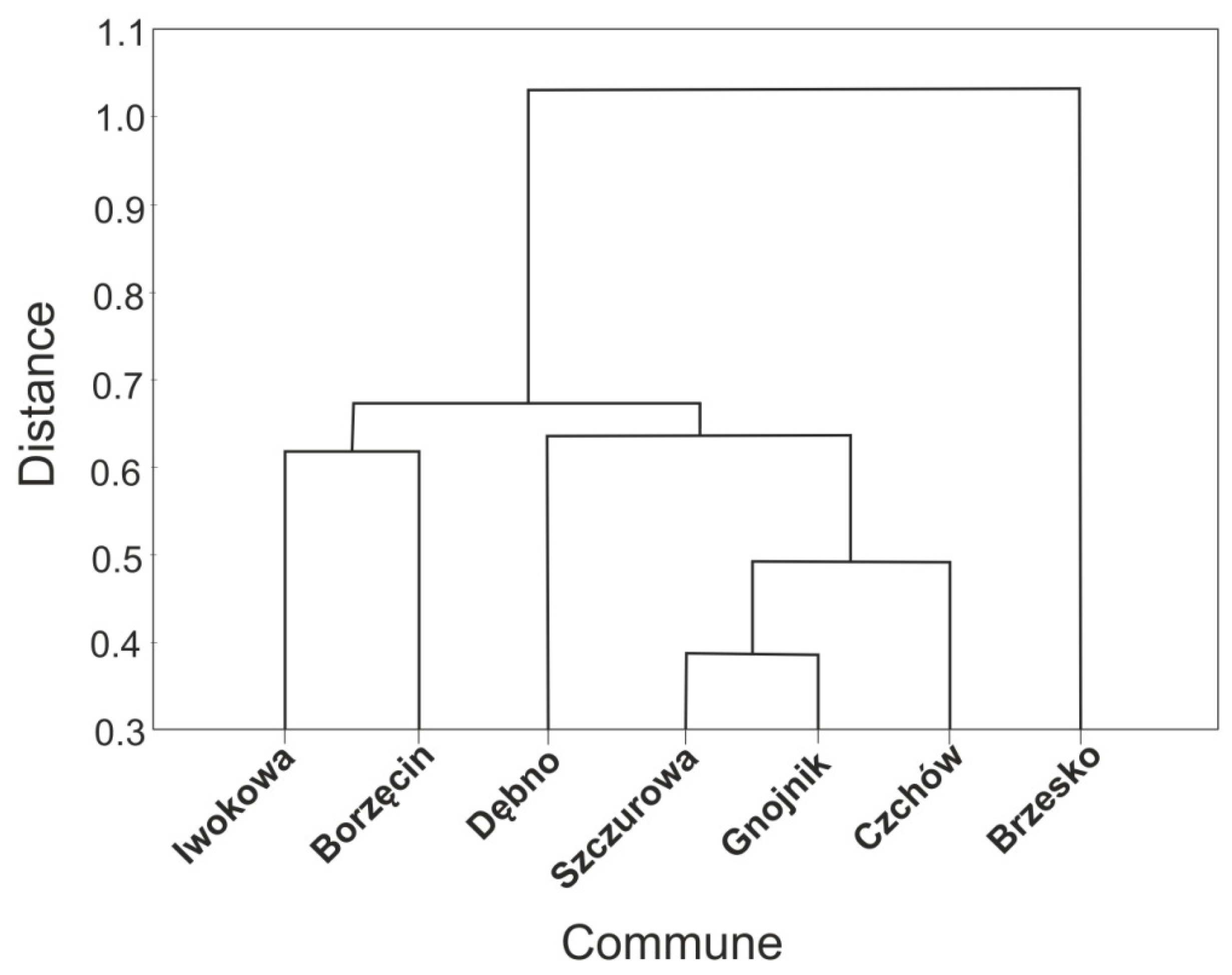
3.1.3. Synthetic Measure of the General Conditions for Tourism Development
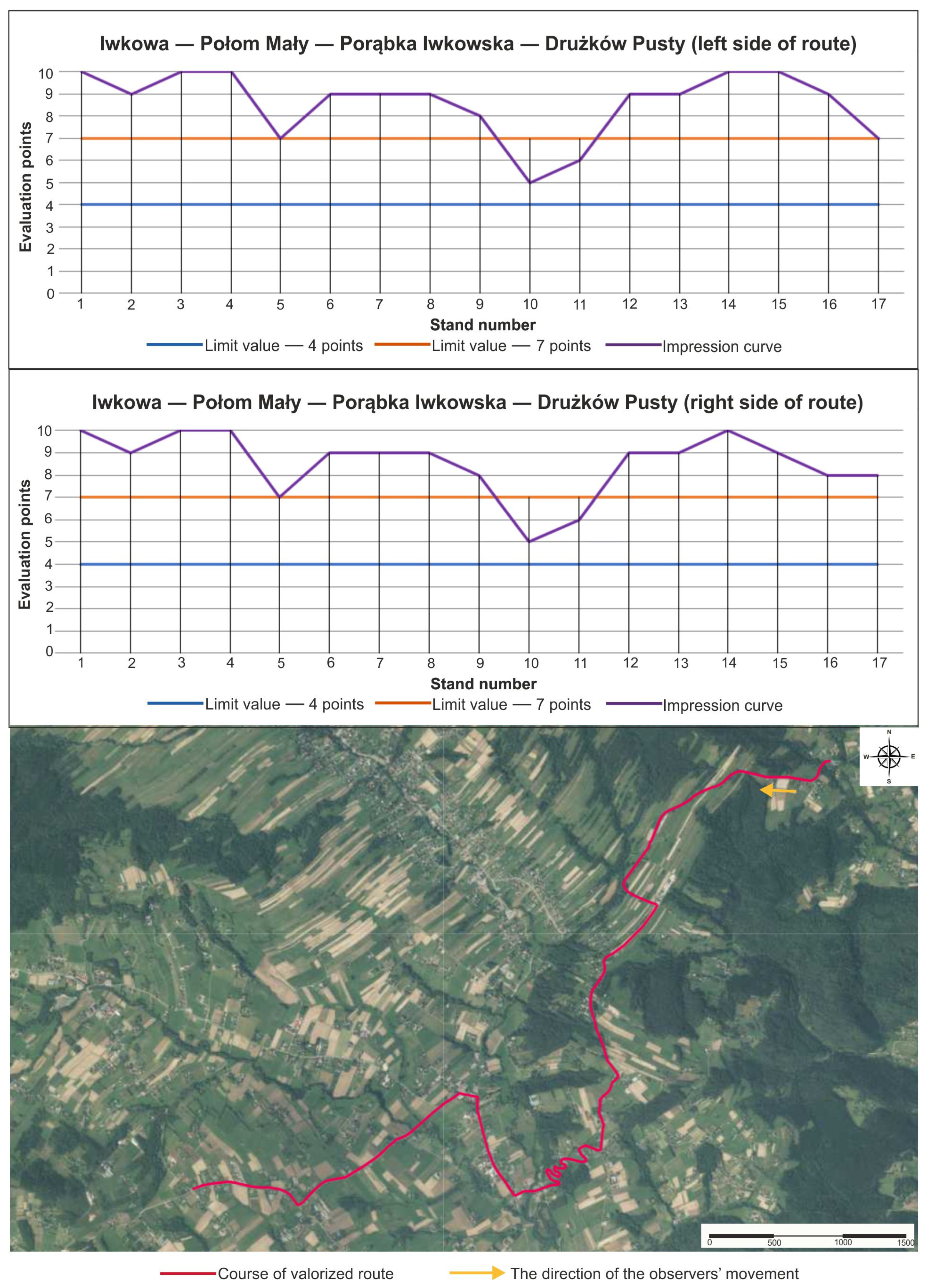
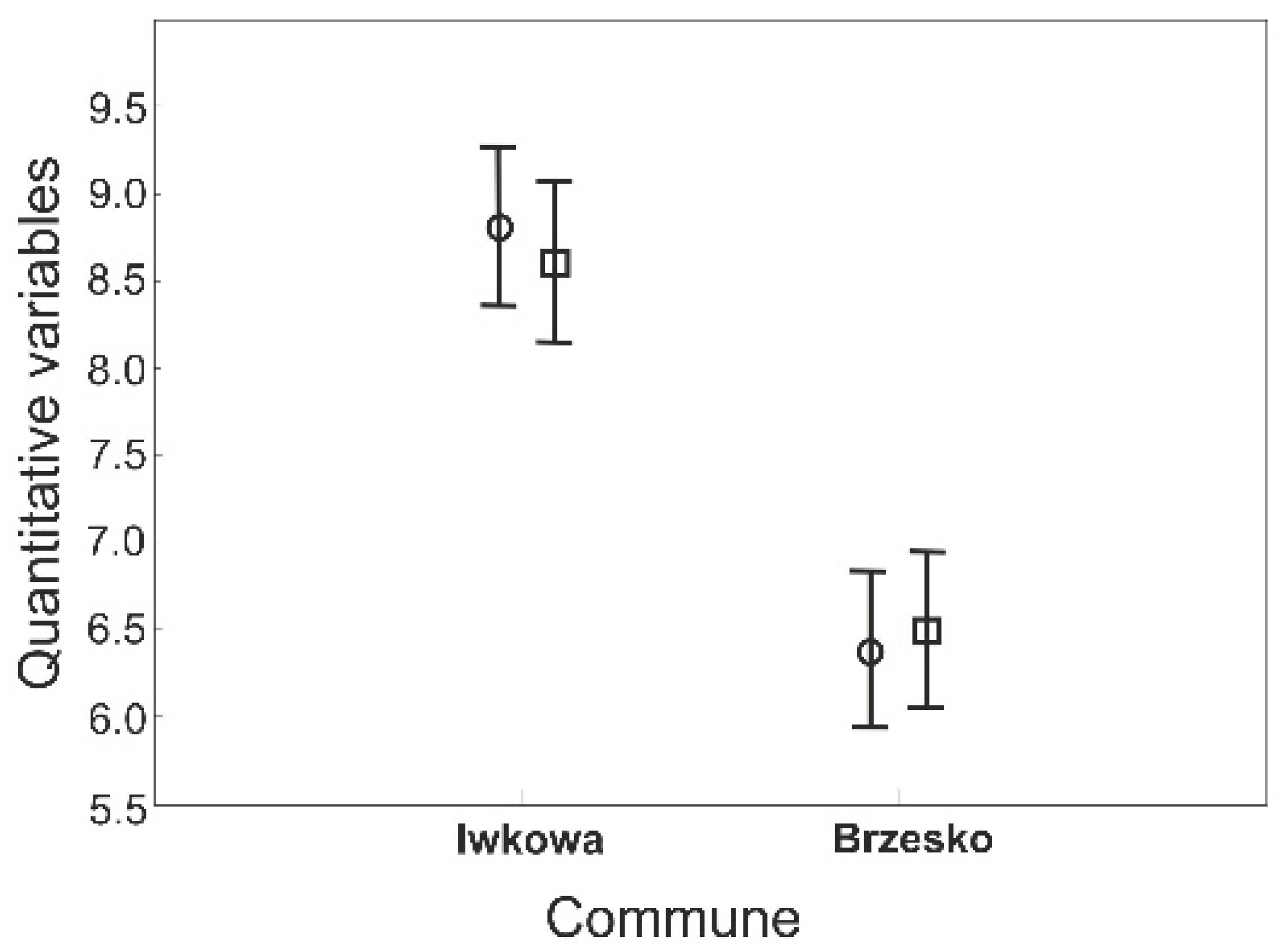
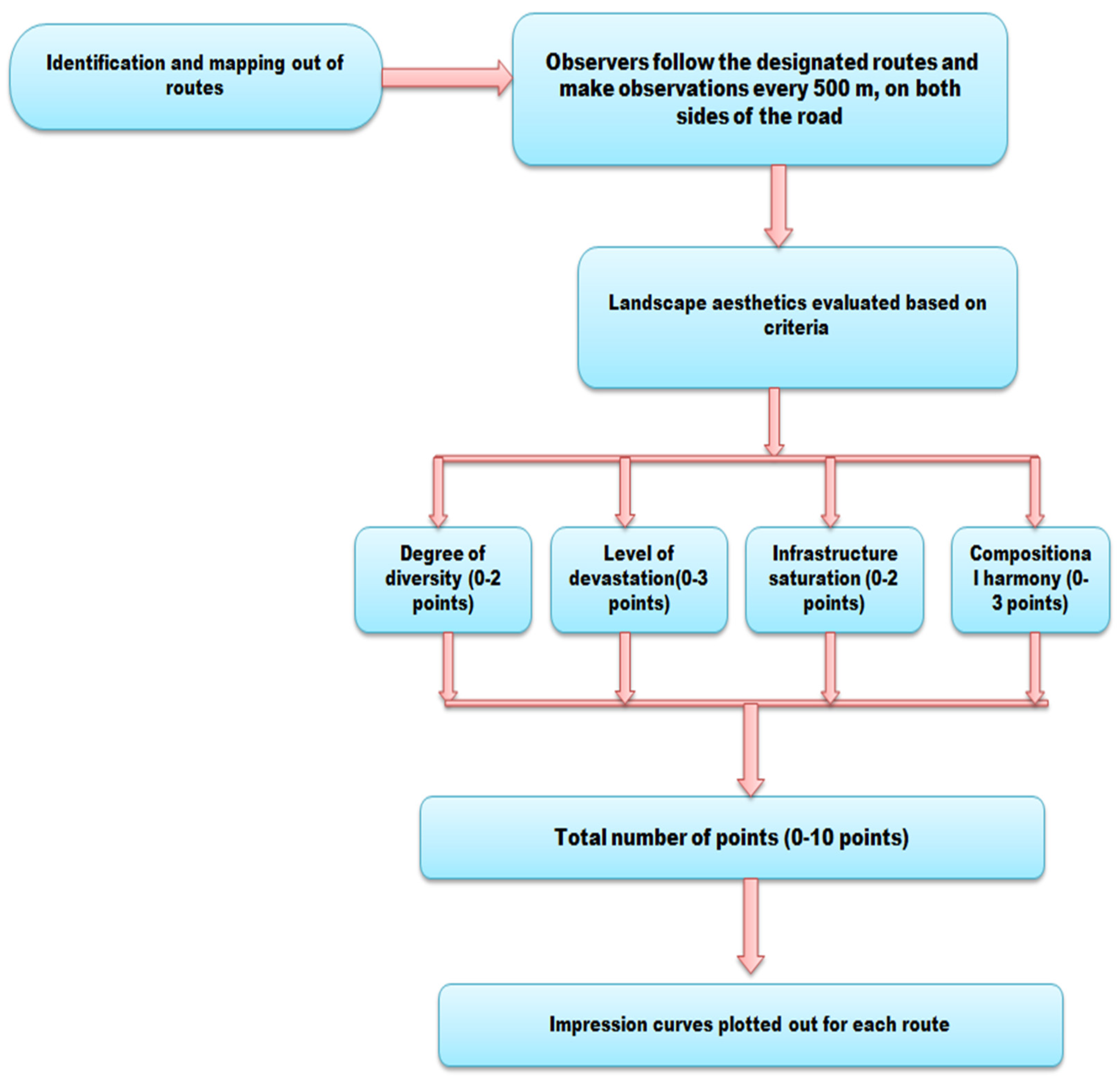
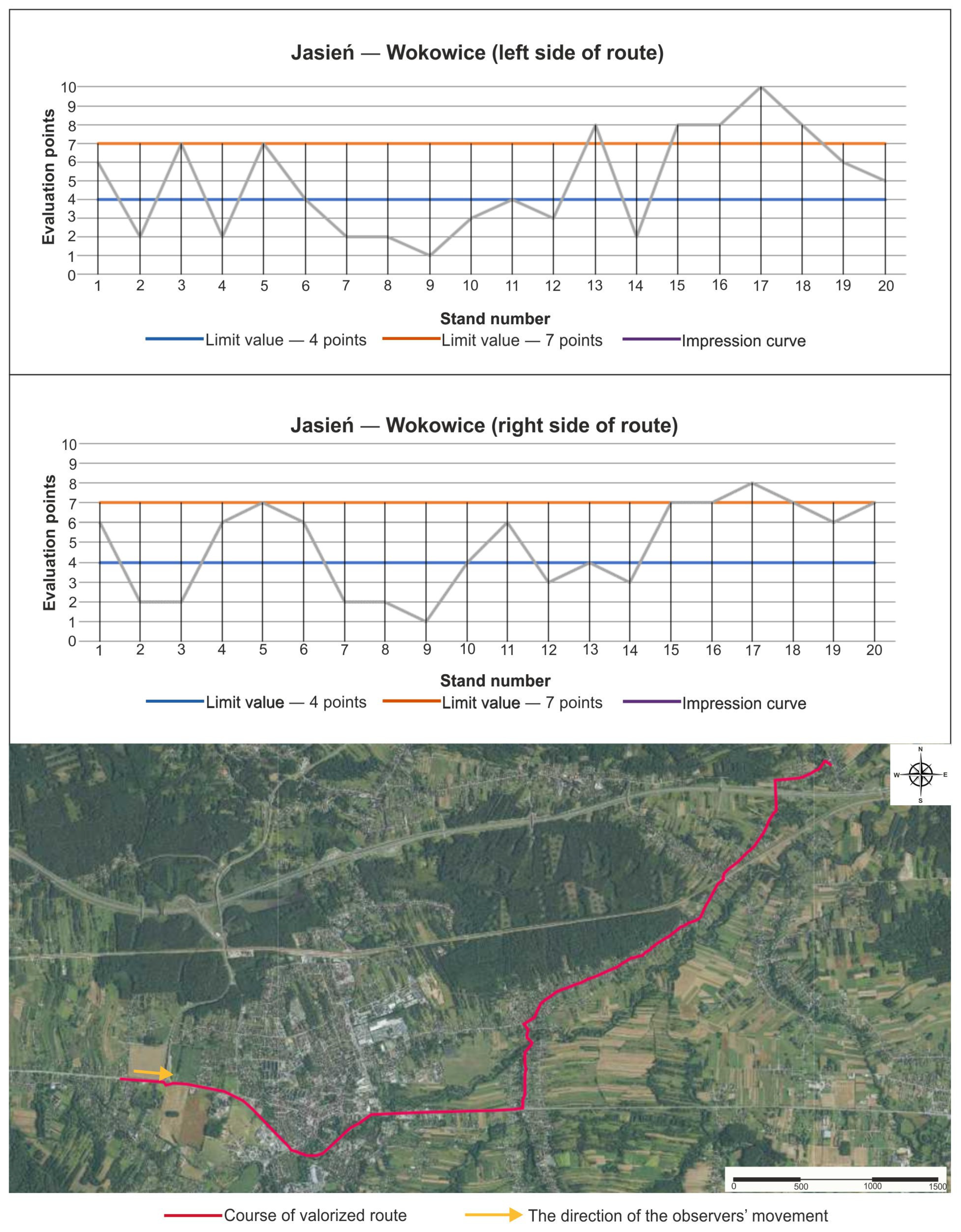
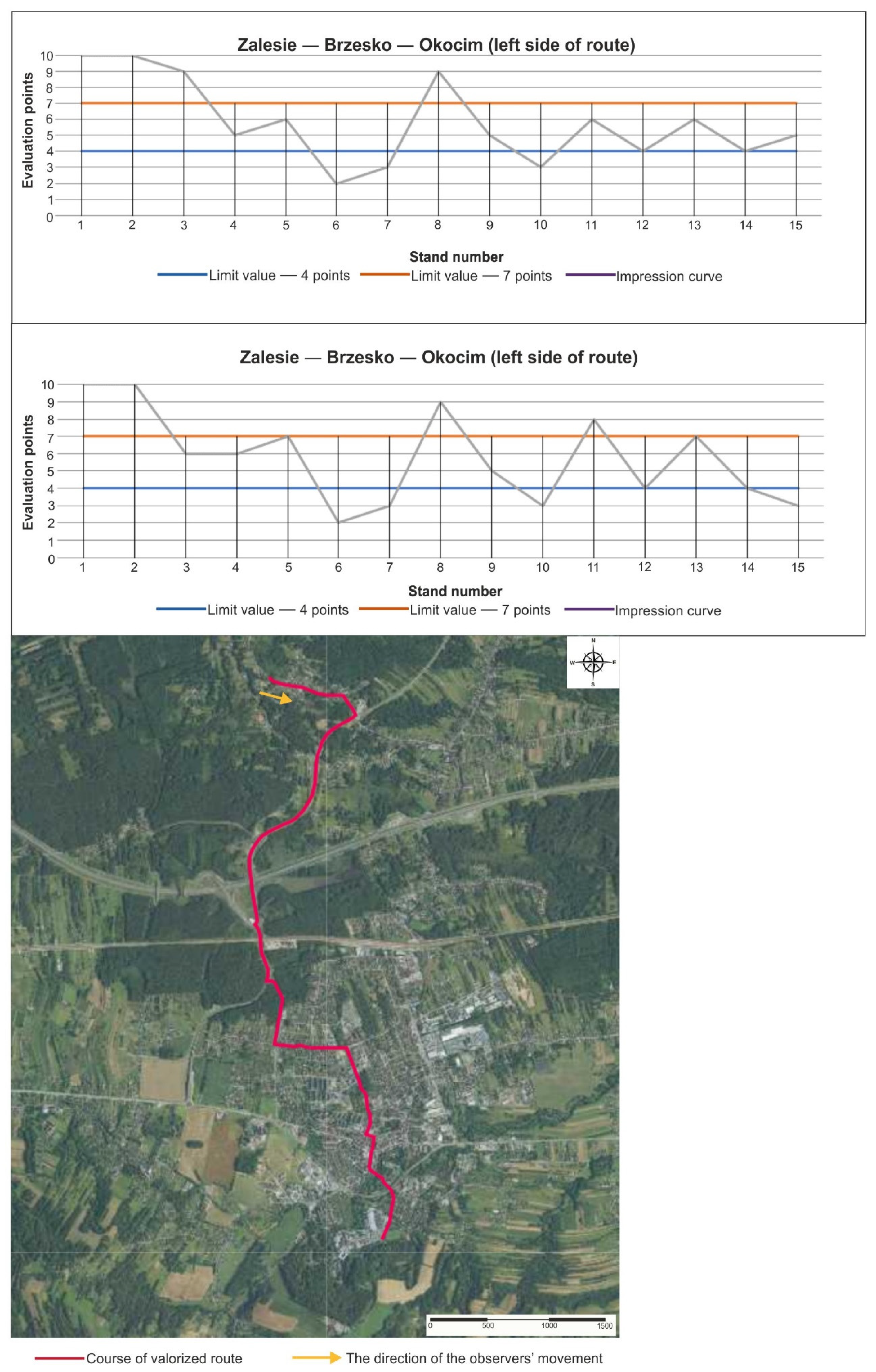
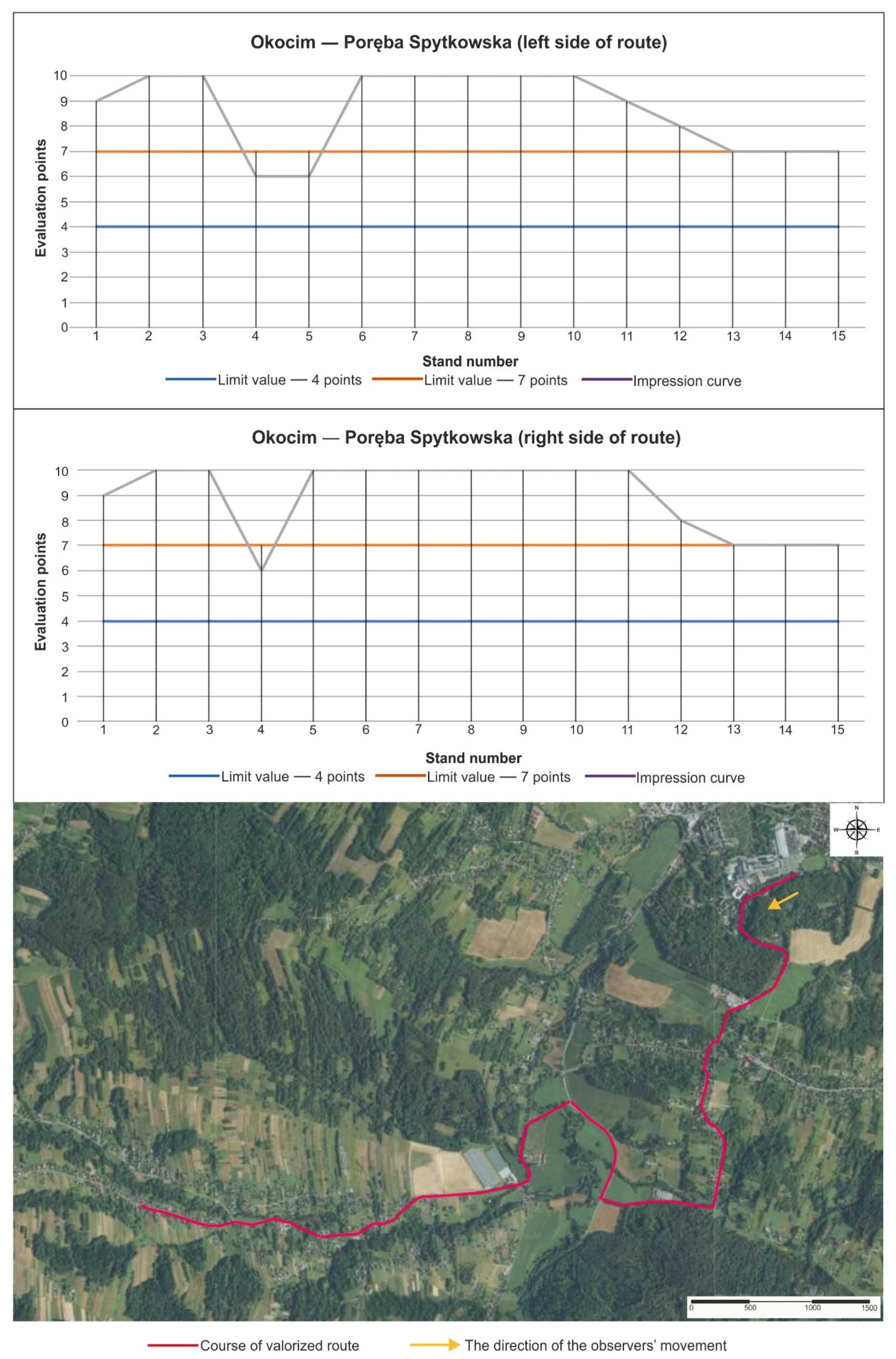
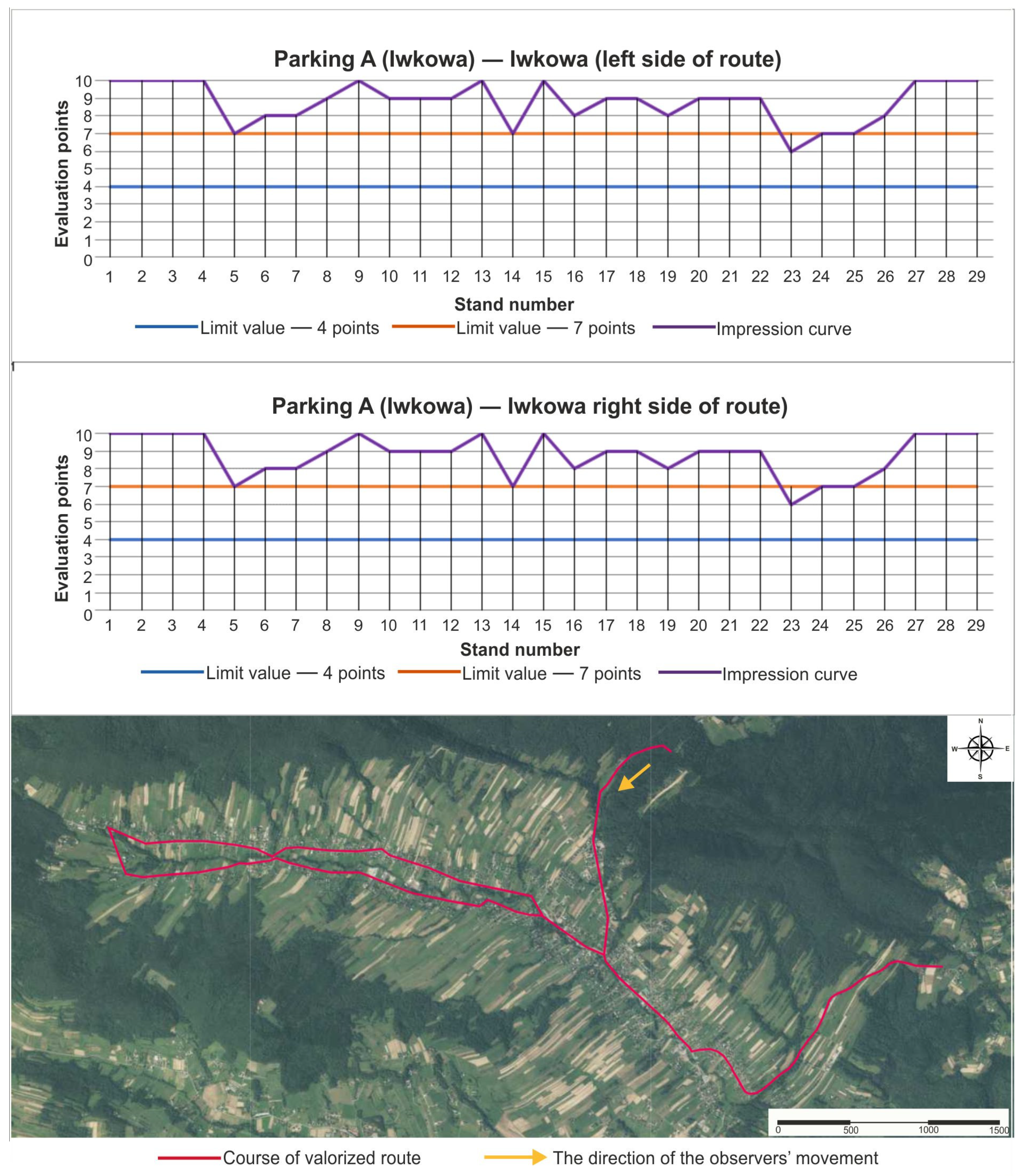
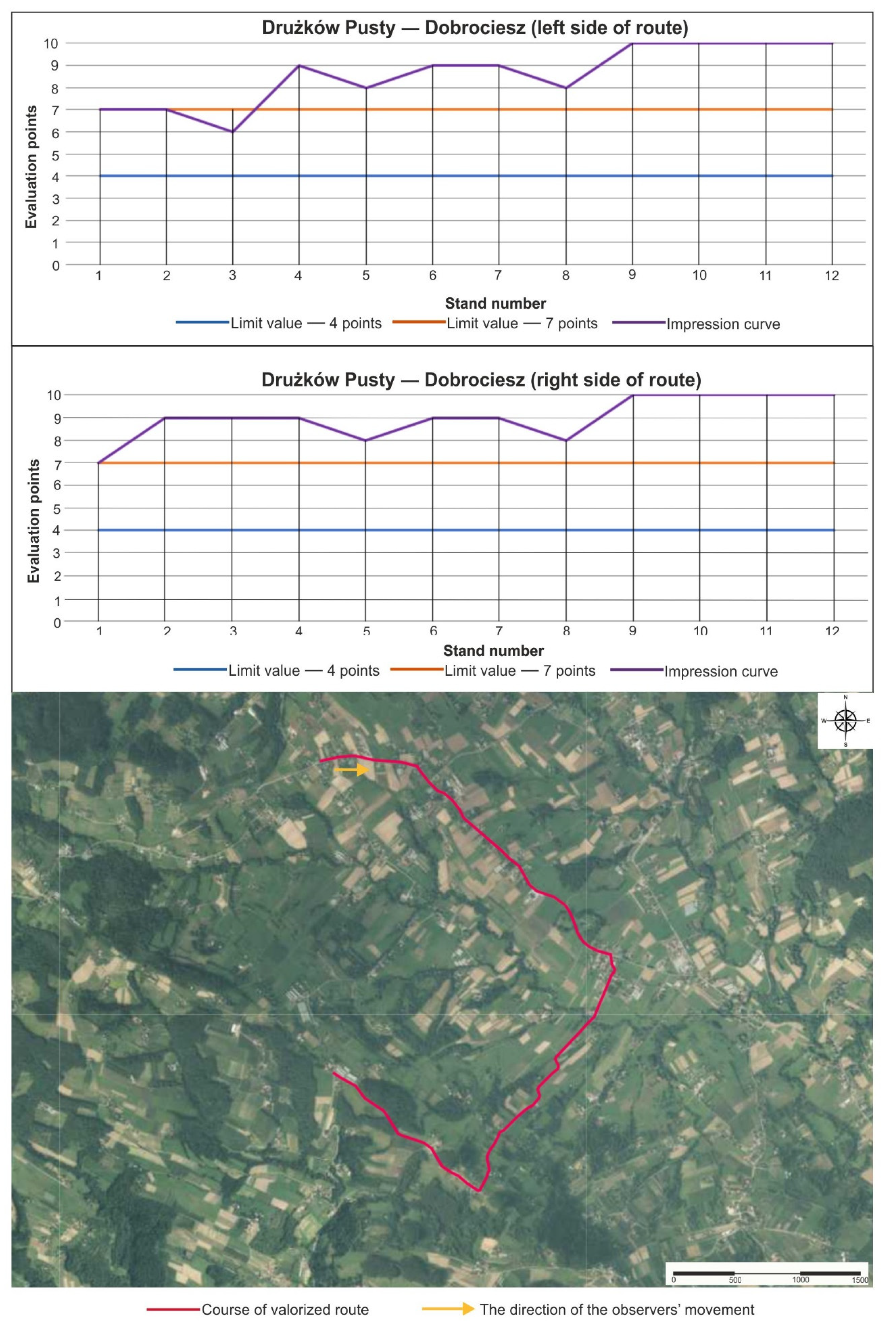
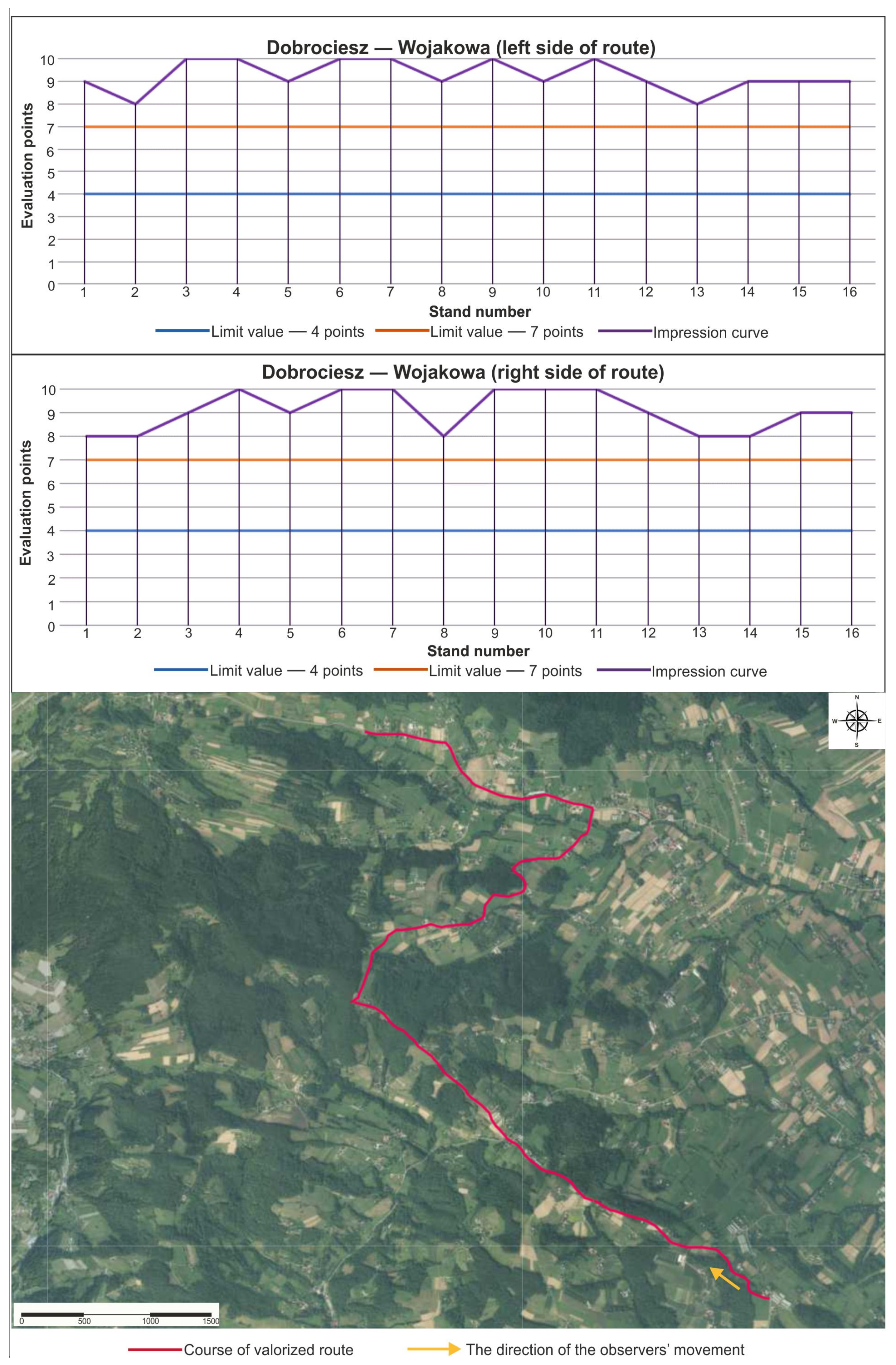
3.2. Aesthetic Landscape Assessments Using Wejchert’s Impression Curve Method
Brzesko Commune
4. Discussion
5. Conclusions
Author Contributions
Funding
Acknowledgments
Conflicts of Interest
References
- Stoicea, D.M. Aspects of the impact of the economic and financial crisis on global tourism. Rev. Tinerilor Econ. 2020, 35, 61–69. [Google Scholar]
- Livandovschi, R.; Melnic, I. The impact of COVID-19 on tourism. In Competitivitatea şi Inovarea în Economia Cunoaşterii; Academia de Studii Economice a Moldovei: Chişinău, Moldova, 2020; pp. 9–12. ISBN 978-9975-75-986-1. [Google Scholar]
- World Tourism Organization. European Union Tourism Trends; UNWTO: Madrid, Spain, 2018. [Google Scholar]
- Harba, J.N.; Parteca, M.; Bujduveanu, S. From Growth, to Chaos, to Uncertainty: The Impact of the COVID-19 Pandemic on European Tourism. In New Trends in Sustainable Business and Consumption, Proceedings of the 2020 Basiq International Conference, Messina, Italy, 4–6 June 2020; University of Messina: Messina, Italy; pp. 1249–1256.
- EEA. Europe’s Environment: The Third Assessment; European Environment Agency: Copenhagen, Denmark, 2003.
- Tucki, A. Regionalne aspekty rozwoju turystyki na przykładzie województwa lubelskiego [Regional aspects of tourism development on the example of the Lublin region]. In Studia nad Turystyką [Tourism Studies]. Prace Geograficzne i Regionalne; Kurek, W., Faracik, R., Eds.; IGiGP, UJ: Kraków, Poland, 2007; pp. 267–279. [Google Scholar]
- Kurek, W.; Mika, M. Waloryzacja Przestrzeni miejskiej Krakowa dla Potrzeb Turystyki [Valorization of Krakow’s Urban Space for the Needs of Tourism]; IGiGP, UJ: Kraków, Poland, 2008; pp. 1–146. [Google Scholar]
- Maliszewski, C. Metody planowania przestrzennego obszarów turystycznych i rekreacyjnych na poziomie lokalnym [Methods of spatial planning of tourist and recreational areas at the local level]. Człowiek Sr. 2016, 40, 59–82. [Google Scholar]
- Kruczek, Z.; Zmyślony, P. Regiony Turystyczne. Podstawy Teoretyczne. Studium Przypadków [Tourist Regions. Theoretical Basics. Case Study], 2nd ed.; Proksenia: Kraków, Poland, 2014; pp. 1–304. [Google Scholar]
- Ferrario, F. The Tourist Landscape: A Method of Evaluating Tourist Potential and Its Application to South Africa. Ph.D. Thesis, Department of Geography, University of California, Berkeley, CA, USA, 1976. [Google Scholar]
- Poria, Y.; Butler, R.; Airey, D. Clarifying heritage tourism: A distinction between heritage tourism and tourism in historic place. Ann. Tour. Res. 2000, 28, 1047–1049. [Google Scholar] [CrossRef] [Green Version]
- Mason, P. Tourism Impacts, Planning and Management, 1st ed.; Butterworth-Heinemann: Oxford, UK, 2003; pp. 1–272. [Google Scholar]
- Scheyvens, R.; Biddulph, R. Inclusive tourism development. Tour. Geogr. 2018, 20, 589–609. [Google Scholar] [CrossRef]
- Ziernicka-Wojtaszek, A.; Zawora, T. Wybrane metody oceny atrakcyjności agroturystycznej terenów wiejskich [Selected methods pertaining to the assessment of agricultural tourism attractiveness of rural regions]. Infrastruct. Ecol. Rural. Areas 2011, 2, 235–245. [Google Scholar]
- Gołembski, G. (Ed.) Regionalne Aspekty Rozwoju Turystyki [Regional Aspects of Tourism Development], 1st ed.; PWN: Warszawa-Poznań, Poland, 1999; pp. 1–206. [Google Scholar]
- Formica, S.; Uysal, M. Destination attractiveness based on supply and demand evaluations: An analytical framework. J. Travel Res. 2006, 44, 418–430. [Google Scholar] [CrossRef]
- Korzeniewski, J.; Kozłowski, M. Development of tourism in Polish poviats in the years 2010–2017. Qual. Quant. 2020, 54, 1591–1612. [Google Scholar] [CrossRef] [Green Version]
- Rząsa, K.; Ogryzek, M.; Źróbek, R. The land transfer from the State Treasury to local government units as a factor of social development of rural areas in Poland. Land 2019, 8, 170. [Google Scholar] [CrossRef] [Green Version]
- Brossard, T.; Wieber, J.C.; Joly, D. Analyse visuelle systématique des paysages de cours d’eau par deux approches complémentaires. Rev. Géographique Lyon 1998, 73, 299–308. [Google Scholar] [CrossRef]
- Brassley, P. On the unrecognized significance of the ephemeral landscape. Landsc. Res. 1998, 23, 119–132. [Google Scholar] [CrossRef]
- Pietrzak, M.; Miedzińska, J.; Styperek, J. “Rzeczywista” Atrakcyjność Wizualna Krajobrazu Szlaków Turystycznych (na Przykładzie Szlaku im. Cyryla Ratajskiego w Wielkopolskim Parku Narodowym) [“Actual” Visual Attractiveness of the Landscape of Tourist Routes (on the example of the Cyryl Ratajski Trail in the Wielkopolska National Park)]. Probl. Ekol. Kraj. 1999, 5, 113–121. [Google Scholar]
- Bell, P.A.; Greene, T.C.; Fischer, J.D.; Baum, A. Environmental Psychology, 5th ed.; Psychology Press: Hove, UK, 2004; pp. 1–654. [Google Scholar]
- Richling, A. Główne kierunki badań nad krajobrazem [Key directions in landscape survey]. Probl. Ekol. Kraj. 2012, 33, 9–15. [Google Scholar]
- Kulczyk, S. Atrakcyjność turystyczna krajobrazu—Przykłady podejścia systemowego [Landscape tourist attraction—The examples of system approach]. Tur. Kult. 2014, 4, 6–15. [Google Scholar]
- Galliano, S.J.; Loeffler, G.M. Scenery Assessment: Scenic Beauty at the Ecoregion Scale; Quigley, T.M., Ed.; General Technical Report PNW-GTR-472; (Interior Columbia Basin Ecosystem Management Project: Scientific Assessment); U.S. Department of Agriculture, Forest Service, Pacific Northwest Research Station: Portland, OR, USA, 2000; p. 30.
- Zając, M.; Bałaga, K.; Janicki, G. Waloryzacja krajobrazu podmiejskiej wsi (okolice Lublina) dla potrzeb gospodarki przestrzennej [The valorisation of the landscape of a suburban village (Lublin’s environs) for the purposes of spatial development]. Probl. Ekol. Kraj. 2014, 37, 77–86. [Google Scholar]
- Lothian, A. Landscape and the philosophy of aesthetics: Is landscape quality inherentin the landscape or in the eye of the beholder? Landsc. Urban Plan. 1999, 44, 177–198. [Google Scholar] [CrossRef]
- Bajerowski, T.; Sanetra, A.; Szczepańska, A. Wycena Krajobrazu: Rynkowe Aspekty Oceny i Waloryzacji Krajobrazu [Valuation of landscape: Market Aspects of the Assessment and Improvement of Landscape], 1st ed.; Educaterra: Olsztyn, Poland, 2000; pp. 1–81. [Google Scholar]
- Wejchert, K. Elementy Kompozycji Urbanistycznej [Elements of Urban Composition], 2nd ed.; Arkady: Warsaw, Poland, 1984; pp. 1–279. [Google Scholar]
- Wejchert, K. Przestrzeń Wokół Nas [The Space Around Us]; FIBA Noma Press: Katowice, Poland, 1993; pp. 1–232. [Google Scholar]
- Cymerman, R.; Falkowski, J.; Hopfer, A. Krajobrazy Wiejskie: Klasyfikacja i Kształtowanie [Rural Landscapes: Classification and Planning]; AR-T: Olsztyn, Poland, 1992; pp. 1–116. [Google Scholar]
- Wejchert, K. Elementy Kompozycji Urbanistycznej [Elements of Urban Composition], 2nd ed.; Arkady: Warsaw, Poland, 1974; pp. 1–280. [Google Scholar]
- Polska, A. Oceny estetyczne krajobrazu [The aesthetic landscape assessments]. In Niematerialne wartości krajobrazów kulturowych [Intangible values of cultural landscapes]. Pr. Kom. Kraj. Kult. 2011, 15, 185–192. [Google Scholar]
- Wang, Y.; Xia, Z.; Chen, W. Aesthetic values in sustainable tourism development: A case study in Zhangjiajie National Park of Wuling Yuan, China. J. China Tour. Res. 2008, 4, 205–218. [Google Scholar] [CrossRef] [Green Version]
- Beza, B. The aesthetic value of a mountain landscape: A study of the Mt. Everest Trek. Landsc. Urban Plan. 2010, 97, 306–317. [Google Scholar] [CrossRef]
- Dong, R.; Dong, Z. Aesthetic evaluation of yardang landforms landscape: The Dunhuang Yardang National Geopark example. Sci. Cold Arid. Reg. 2018, 7, 265–271. [Google Scholar] [CrossRef]
- Hoppstadius, F. Tourists’ reflections on sustainability in a biosphere reserve landscape. Int. J. Tour. Res. 2019, 21, 560–573. [Google Scholar] [CrossRef]
- Schirpke, U.; Altzinger, A.; Leitinger, G.; Tasser, E. Change from agricultural to touristic use: Effects on the aesthetic value of landscapes over the last 150 years. Landsc. Urban Plan. 2019, 187, 23–35. [Google Scholar] [CrossRef]
- Kondracki, J. Geografia Regionalna Polski [Regional Geography of Poland], 3rd ed.; PWN: Warszawa, Poland, 2011; pp. 1–468. [Google Scholar]
- Statistics Poland (GUS), Local Data Bank. Available online: https://bdl.stat.gov.pl/BDL/start (accessed on 1 September 2021).
- Prus, B.; Król, K. Ocena zastosowania wybranych metod taksonomicznych do klasyfikacji zjawisk społeczno-gospodarczych [Evaluation of using selected taxonomic methods to classify socio-economic phenomena]. Acta Sci. Pol. Form. Circumiectus 2017, 16, 179–197. [Google Scholar] [CrossRef]
- Hakuć-Błażowska, A.; Pacek, N.; Kupren, K.; Furgała-Selezniow, G. Comparison of tourist attractiveness of rural and urban-rural communes of Elbląg County. Studia Obsz. Wiej. 2018, 50, 81–99. [Google Scholar] [CrossRef]
- Porteous, J.D. Environmental Aesthetics. Ideas, Politics and Planning, 1st ed.; Taylor & Francis: London, UK, 2004; pp. 1–312. [Google Scholar]
- Dakin, S. There’s more to landscape than meets the eye: Towards inclusive landscape assessment in resource and environmental management. Can. Geogr. Le Ge´Ographe Can. 2003, 47, 185–200. [Google Scholar] [CrossRef]
- Surová, D.; Pinto-Correia, T. Landscape preferences in the cork oak Montado region of Alentejo, southern Portugal: Searching for valuable landscape characteristics for different user groups. Landsc. Res. 2008, 33, 311–330. [Google Scholar] [CrossRef]
- Stephenson, J. The dimensional landscape model: Exploring differences in expressing and locating landscape qualities. Landsc. Res. 2010, 35, 299–318. [Google Scholar] [CrossRef]
- Daniel, T.C.; Vining, J. Methodological issues in the assessment of landscape quality. In Human Behavior and Environment, 1st ed.; Altman, I., Wohlwill, J.F., Eds.; Springer: Boston, MA, USA, 1983; Volume 6, pp. 39–84. [Google Scholar]
- Kupidura, A.; Łuczewski, M.; Kupidura, P. Wartość Krajobrazu. Rozwój Przestrzeni Obszarów Wiejskich [Landscape Value. Spatial Development of Rural Areas], 1st ed.; PWN: Warsaw, Poland, 2011; pp. 1–106. [Google Scholar]
- Czubaszek, R.; Wysocka-Czubaszek, A.; Brzózko, A. Waloryzacja krajobrazu gminy wiejskiej Wysokie Mazowieckie [The assessment of the landscape quality of the Wysokie Mazowieckie rural commune]. Probl. Ekol. Kraj. 2016, 16, 81–93. [Google Scholar]
- Pukowiec, K.; Kurda, W. Ocena atrakcyjności turystyczno-rekreacyjnej gmin powiatu lublinieckiego [Evaluation of the tourist and recreational attractiveness of the communes in the county of lubliniec]. Zesz. Nauk. Wyższej Szkoły Przymierza Rodz. Warszawie 2013, 11, 7–20. [Google Scholar]
- Tokarska-Osyczka, A.; Iszkuło, G. Waloryzacja przyrodniczo-krajobrazowa, kulturowa oraz ocena atrakcyjności turystycznej gmin na terenie Pojezierza Międzychodzko-Sierakowskiego [Valorization of nature, landscape and cultural and tourist attractiveness rating communis in the Międzychodzko-Sierakowski Lakeland]. Zesz. Nauk. Inżynieria Sr. Uniw. Zielonogórski 2014, 153, 67–81. [Google Scholar]
- Połucha, I.; Marks, E. Ocena walorów przyrodniczych i kulturowych gminy Reszel pod kątem rozwoju turystyki [The evaluation of the natural and cultural values of the municipality Reszel for tourism development]. Acta Sci. Pol., Adm. Locorum 2012, 11, 177–198. [Google Scholar]
- Lee, C.F.; Huang, H.I.; Yeh, H.R. Developing an evaluation model for destination attractiveness: Sustainable forest recreation tourism in Taiwan. J. Sustain. Tour. 2010, 18, 811–828. [Google Scholar] [CrossRef]
- Cracolici, M.F.; Nijkamp, P. The attractiveness and competitiveness of tourist destinations: A study of Southern Italian regions. Tour. Manag. 2008, 30, 336–344. [Google Scholar] [CrossRef]
- Mazurski, K.R. Pojęcie krajobrazu i jego ocena [The concept of landscape and its assessment]. In Mijające krajobrazy Polski, Dolny Śląsk—Krajobraz Dolnośląski Kalejdoskopem Jest ... [The passing landscapes of Poland, Lower Silesia—The Lower Silesian landscape A kaleidoscope It Is ... ], 1st ed.; Mazurski, K.R., Ed.; Proksenia: Kraków, Poland, 2012; pp. 11–18. [Google Scholar]
- Dwyer, L.; Jago, L.; Forsyth, P. Economic evaluation of special events: Reconciling economic impact and cost–benefit analysis. Scand. J. Hosp. Tour. 2016, 16, 115–129. [Google Scholar] [CrossRef]
- Markowski, J.; Bartos, M.; Rzenca, A.; Namiecinski, P. An evaluation of destination attractiveness for nature-based tourism: Recommendations for the management of national parks in Vietnam. Nat. Conserv. 2019, 32, 51–80. [Google Scholar] [CrossRef] [Green Version]
- Krzymowska-Kostrowicka, A. Geoekologia Turystyki i Wypoczynku [Geoecology of Tourism and Recreation], 2nd ed.; PWN: Warsaw, Poland, 1999; pp. 1–239. [Google Scholar]
- Scolozzi, R.; Schirpke, U.; Detassis, C.; Abdullah, S.; Gretter, A. Mapping alpine landscape values and related threats as perceived by tourists. Landsc. Res. 2014, 40, 451–465. [Google Scholar] [CrossRef]
- Cho, S.; Poudyal, N.C.; Roberts, R.K. Spatial analysis of the amenity value of green open space. Ecol. Econ. 2008, 66, 403–416. [Google Scholar] [CrossRef]
- Domon, G. Landscape as resource: Consequences, challenges and opportunities for rural development. Landsc. Urban Plan. 2011, 100, 338–340. [Google Scholar] [CrossRef]
- Senetra, A. Las jako istotny komponent przestrzeni w aspekcie opracowywania map wartości krajobrazów wiejskich [Forests as an important spatial element in elaboration of the esthetic value maps for rural landscapes]. Sylwan 2015, 159, 757–766. [Google Scholar]
- Gracz, J.; Sankowski, T. Psychologia w Rekreacji i Turystyce [Psychology in Recreation and Tourism]; AWF: Poznań, Poland, 2004; pp. 1–262. [Google Scholar]
- Malinowska, E. Wpływ atrakcyjności wizualnej krajobrazu na potencjał turystyczny Narwiańskiego Parku Narodowego i jego otuliny [The influence of visual quality of landscape on the touristic potential of the Narwiański National Park and its buffer zone]. Probl. Ekol. Kraj. 2010, 27, 277–285. [Google Scholar]
- Adamiec, P. Wykorzystanie walorów przyrodniczo-krajobrazowych dolin rzecznych Lublina w rekreacji [The role of natural and landscape values of Lublin rivers in recreation]. Nauka Przyr. Technol. 2008, 2, 1–9. Available online: http://www.npt.up-poznan.net/tom2/zeszyt4/art_47.pdf (accessed on 18 September 2021).
- Mordwa, S. Krzywa wrażeń dla ulicy Piotrkowskiej w Łodzi [Piotrkowska street in Łódź sensations curve]. Acta Univ. Lodz. Folia Geogr. Socio-Oeconomica 2009, 10, 89–98. [Google Scholar]
- Pisarek, M.; Gargała-Polar, M. Waloryzacja przyrodnicza i kulturowa żółtego szlaku turystycznego „Dookoła Rzeszowa” [Natural and cultural investigation of the yellow tourist route “Dookoła Rzeszowa”]. Zesz. Nauk. Tur. Rekreac. 2019, 1, 115–123. [Google Scholar]
- Wiatrak, A.P. Zagadnienia rozwijania turystyki w strategiach rozwoju lokalnego [Issues of developing tourism in local development strategies]. In Instytucjonalne i Strukturalne Aspekty Rozwoju Rolnictwa i Obszarów Wiejskich [Institutional and Structural Aspects of Agricultural and Rural Development], 1st ed.; Przygodzka, R., Gruszewska, E., Eds.; Wyd. Uniwersytetu w Białymstoku: Białystok, Poland, 2020; pp. 131–144. [Google Scholar]
- Butler, R.W. Sustainable tourism: A state of the art review. Tour. Geogr. 1999, 1, 7–25. [Google Scholar] [CrossRef] [Green Version]
- Para, A. Zasady zrównoważonego rozwoju turystyki—Bariery i szanse dla branży turystycznej [Principles of sustainable development—Barriers and opportunities for tourism industry]. In Zrównoważony Rozwój w Turystyce w Różnych Perspektywach Analitycznych [Sustainable Development in Tourism in Various Analytical Perspectives], 1st ed.; Kozikowska, M., Ed.; Zeszyty Naukowe. Turystyka i Rekreacja 11(1), Wyższa Szkoła Turystyki i Języków Obcych: Warszawa, Poland, 2013; pp. 5–16. [Google Scholar]
- Przeorek-Smyka, R. Determinanty prawne zrównoważonego rozwoju turystyki w Unii Europejskiej i w Polsce. Wybrane problemy [Law determinants of sustainable tourism development in the UE and Poland. Selected problems]. In Gospodarka Turystyczna w Regionie. Rynek Turystyczny—Współczesne Trendy, Problemy i Perspektywy Jego Rozwoju [Tourist Economy in the Region. Tourist Market—Contemporary Trends, Problems and Prospects for Its Development], 1st ed.; Rapacz, A., Ed.; Pr. Nauk. Uniwersytetu Ekonomicznego we Wrocławiu: Wrocław, Poland, 2013; Volume 304, pp. 241–252. [Google Scholar]


| Domains | Weight | Subdomains | Weights |
|---|---|---|---|
| Attractiveness for tourists | 0.50 | Tourist attractions | 0.40 |
| State of the environment | 0.15 | ||
| Environmental protection | 0.15 | ||
| Transport links | 0.10 | ||
| Accommodation, catering and accompanying facilities | 0.20 | ||
| Attractiveness for investors | 0.50 | Service infrastructure | 0.32 |
| Technical infrastructure | 0.25 | ||
| Societal relations | 0.23 | ||
| Communal finances | 0.20 |
| Domain of Analysis | Number | Feature | Unit of Measurement | Weight |
|---|---|---|---|---|
| Attractiveness for tourists | Tourist attractions | |||
| 1. | forest area | ha | 0.25 | |
| 2. | arable area | ha | 0.05 | |
| 3. | number of natural monuments | number of sites | 0.15 | |
| 4. | museums | number of sites | 0.10 | |
| 5. | major sights | number of sites | 0.15 | |
| 6. | length of tourist trails | km/km2 | 0.20 | |
| 7. | number of cultural events taking place in the county | number of events/365*100 | 0.10 | |
| State of the environment | ||||
| 8. | amount of communal waste collected during the year | metric tons | 0.40 | |
| 9. | share of biologically treated wastewater in amount of wastewater requiringcleansing | % | 0.60 | |
| Environmental protection | ||||
| 10. | ratio of the capacity of wastewater treatment plants requiring treatment | m3/day | 0.60 | |
| 11. | illegal landfill sites removed during the year | number of sites | 0.40 | |
| Transport links | ||||
| 12. | length of regional roads | km/km2 | 0.35 | |
| 13. | length of national roads | km/km2 | 0.35 | |
| 14. | number of railway stations | number/km2 | 0.30 | |
| Accommodation, catering and accompanying facilities | ||||
| 15. | hotels | number of sites | 0.12 | |
| 16. | pensions | number of sites | 0.10 | |
| 17. | hostels | number of sites | 0.04 | |
| 18. | resorts | number of sites | 0.05 | |
| 19. | guestrooms | number of sites | 0.05 | |
| 20. | ecotourism farms | number of sites | 0.06 | |
| 21. | restaurants | number of sites | 0.10 | |
| 22. | cafes | number of sites | 0.08 | |
| 23. | bars | number of sites | 0.05 | |
| 24. | other catering establishments | number of sites | 0.06 | |
| 25. | sports fields | number of sites | 0.05 | |
| 26. | gyms | number of sites | 0.04 | |
| 27. | swimming pools | number of sites | 0.04 | |
| 28. | bathing sites | number of sites | 0.04 | |
| 29. | winter-sports equipment rentals | number of sites | 0.04 | |
| 30. | rentals of scuba equipment | number of sites | 0.04 | |
| 31. | bicycle rentals | number of sites | 0.04 | |
| Domain of Analysis | Number | Feature | Unit of Measurement | Weight |
|---|---|---|---|---|
| Attractiveness for investors | Service infrastructure | |||
| 32. | shops | number of sites | 0.25 | |
| 33. | pharmacies | number of sites | 0.10 | |
| 34. | health centers and clinics | number of sites | 0.10 | |
| 35. | gas stations | number of sites | 0.25 | |
| 36. | ATMs | number of sites | 0.20 | |
| 37. | banks and exchange offices | number of sites | 0.10 | |
| Technical infrastructure | ||||
| 38. | length of sewage network | km/km2 | 0.35 | |
| 39. | length of water mains | km/km2 | 0.35 | |
| 40. | population using the gas network | number/number in total | 0.30 | |
| Societal relations | ||||
| 41. | population density | number of persons/km2 | 0.60 | |
| 42. | unemployment rate | % | 0.40 | |
| Communal finances | ||||
| 43. | revenue per capita | PLN/year | 0.30 | |
| 44. | total revenue of communes | PLN/year | 0.40 | |
| 45. | own income of the commune—property tax | PLN/year | 0.15 | |
| 46. | share of subsidies and subventions in total communal revenue | % | 0.15 | |
| Points | Evaluation Criteria | |||
|---|---|---|---|---|
| Degree of Diversity | Level of Devastation | Infrastructure Saturation | Compositional Harmony | |
| 0 | Monotonous, homogeneous landscape | More than 50% of the area devastated | Infrastructure elements account for more than 50% of the area | No harmony |
| 1 | Monotonous landscape with individual enlivening elements | Damaged areas cover 10 to 50% of the terrain | Individual infrastructure elements that cover 10–50% of the area in sight | Some of the elements are compositionally good, others are not, e.g., they fit into the profile, and there is a lack of composition with the vegetation |
| 2 | Large variety of landscape, many individual trees, groups of shrubs | Damaged areas cover up to 10% of the terrain | Individual infrastructure elements in sight cover less than 10% of the area | Most of the elements are compositionally good, only some need repair |
| 3 | --- | Undeveloped landscape | --- | All elements are compositionally good, infrastructure elements are integrated with the profile and vegetation |
| Iwkowa | Brzesko | ||
|---|---|---|---|
| Left | Right | Left | Right |
| 8.8 | 8.2 | 4.9 | 4.8 |
| 8.6 | 8.5 | 6.7 | 6.9 |
| 8.6 | 9.0 | 5.8 | 5.8 |
| 9.3 | 9.1 | 8.6 | 8.9 |
Publisher’s Note: MDPI stays neutral with regard to jurisdictional claims in published maps and institutional affiliations. |
© 2021 by the authors. Licensee MDPI, Basel, Switzerland. This article is an open access article distributed under the terms and conditions of the Creative Commons Attribution (CC BY) license (https://creativecommons.org/licenses/by/4.0/).
Share and Cite
Ziernicka-Wojtaszek, A.; Malec, M. Evaluating Local Attractiveness for Tourism and Recreation—A Case Study of the Communes in Brzeski County, Poland. Land 2022, 11, 39. https://doi.org/10.3390/land11010039
Ziernicka-Wojtaszek A, Malec M. Evaluating Local Attractiveness for Tourism and Recreation—A Case Study of the Communes in Brzeski County, Poland. Land. 2022; 11(1):39. https://doi.org/10.3390/land11010039
Chicago/Turabian StyleZiernicka-Wojtaszek, Agnieszka, and Magdalena Malec. 2022. "Evaluating Local Attractiveness for Tourism and Recreation—A Case Study of the Communes in Brzeski County, Poland" Land 11, no. 1: 39. https://doi.org/10.3390/land11010039
APA StyleZiernicka-Wojtaszek, A., & Malec, M. (2022). Evaluating Local Attractiveness for Tourism and Recreation—A Case Study of the Communes in Brzeski County, Poland. Land, 11(1), 39. https://doi.org/10.3390/land11010039