Article

The Evolution and Influencing Factors of Total Factor Productivity of Grain Production Environment: Evidence from Poyang Lake Basin, China

1
Institute of Statistics and Applied Mathematics, Anhui University of Finance & Economics, Bengbu 233000, China
2
Department of Sociology, Faculty of Social Science, University of Macau, Macau SAR, China
3
School of Finance, Anhui University of Finance & Economics, Bengbu 233000, China
4
Land Satellite Remote Sensing Application Center, Ministry of Natural Resources, Beijing 100048, China
*
Author to whom correspondence should be addressed.
These authors contributed equally to this work.
Land 2021, 10(6), 606; https://doi.org/10.3390/land10060606
Submission received: 4 February 2021 / Revised: 5 March 2021 / Accepted: 14 March 2021 / Published: 7 June 2021

Abstract

:
The total factor productivity (hereafter TFP) of grain production is important to achieve balanced development, while environmental factors are an important part of TEP. In order to explore the characteristics and patterns of the temporal and spatial evolution of the environmental total factor productivity (hereafter ETFP), the Malmquist-Luerberger index, and the spatial autoregressive panel (SAR panel) model were adopted to analyze the evolutionary rules and the influencing factors of ETFP. In this study, we took Poyang Lake, one of China’s main grain production areas, as a study area, and carried out empirical research based on grain production statistical data. The results show that: (1) ETFP shows a growth trend with the increase of grain production from 2001 to 2017, and a great potential for improvement exists. Moreover, from the perspective of time sequence evolution and decomposition of ETFP, which belongs to the dual-track driver of environmental technical efficiency and environmental technological progress, relevant technologies play an important role in promoting the improvement of TEFP; (2) Given that the objective conditions of gain production remain unchanged, the fact that the urbanization rate and average annual rainfall have a negative effect on ETFP, the explanatory variables such as the business scale per worker, the proportion of grain growing population, industrial agglomeration, the proportion of grain sown area and the average annual temperature all play a positive role. Among the variables, the business scale per worker and the proportion of grain growing population significantly affect ETFP at the 1% level. The average annual rainfall, industrial agglomeration and the proportion of grain sown area significantly affect the ETFP at the 5% level. The average annual temperature significantly affects the ETFP at the 10% level.

1. Introduction

Grain is an essential output of agriculture production. Having a sufficient grain supply is not only the material basis for human survival, but also an important guarantee for national economic development, social harmony and stability, and national security. The Chinese central government has issued a series of policies to support and encourage agriculture development. For example, the Chinese central government abolished agricultural taxes and has granted grain subsidies to peasants planting grains since 2014, which significantly increased the farmers’ enthusiasm and led to a steadily increase in the grain output. Nowadays, China has a production capacity of 600 million tons per year, and the annual output per capita has exceeded 450 kg for seven consecutive years. By 2018, China’s grain output reached 657.892 million tons (including 61,003.6 tons of grains, 19.203 million tons of beans, and 28.654 million tons of potatoes) [1]. At the same time, due to the shrinking of farmland regions, farmland quality decline, farmland restructuring, as well as fallowing and uncultivated land, the grain sown area has been greatly reduced in recent years and non-grain production has become more serious, thereby posing a potential threat to food security to a certain extent [1]. With the rapid development of the economy, agricultural non-point source pollution is becoming more and more serious in the process of grain production. Taking chemical fertilizer as an example, the current annual consumption of chemical fertilizer is 59.841 million tons, which has greatly harmed the environment. In terms of water pollution, 97.15 million tons of inorganic nitrogen flows into the Yangtze River, the Yellow River, and the Pearl River every year, 90% of which comes from agricultural production [2]. Therefore, ensuring the safe and stable production of food, improving the efficiency of food production under environmental constraints, and optimizing the spatial distribution of food production will become the focus points of China’s agricultural policy in the future.
A substantial body of literature on grain production efficiency focused on the research methodologies and influencing factors of grain production efficiency. Scholars’ research methodologies on grain production efficiency included parametric and nonparametric methods. The parametric method is used to measure production efficiency by constructing production frontier functions. In general, the most commonly used method is called Stochastic Frontier Analysis (SFA). For example, Battese [3] measured the rice production efficiency of India farmers based on SFA. This method has been widely used in the measurement of grain production efficiency [4,5,6]. Compared with the parametric method, the nonparametric method does not need to set the specific function form, thereby avoiding errors in calculation results caused by the wrong selection of production functions. In the field of efficiency evaluation, nonparametric methods are widely used [7,8,9]. Nonparametric methods include Data Envelopment Analysis (DEA) and Free Disposal Hull (FDH), which belongs to the category of linear programming modeling. Production convexity assumption is often added to the DEA method based on the constraints of the FDH method. Among these methods, DEA is the most widely used mainstream one to measure grain production efficiency, whereas the FDH method is used less [10,11]. The above measures are based on traditional grain production efficiency. With the increasingly serious environmental problems that are emerging, traditional efficiency research methods cannot meet the needs of existing studies. For this reason, some scholars turned to studying problems such as the agricultural non-point source pollution, industrial waste, and other environmental issues to improve the traditional efficiency model scientifically and reasonably. The most common DEA methods include the radial Directional Distance Function (DDF) and non-radial Slack Based Measure (SBM) methods. DDF is a method that can deal with undesired output, which has been extended by Chung [12] from different improved directions of input and output on the basis of Shephard distance function and is widely used [13,14]. The SBM model was proposed by Tone in 2001. Compared with the DDF model, SBM has the advantage of considering the redundancy of production factors. Therefore, the SBM model is favored by many scholars [15].
Existing literature documented that grain production efficiency would be affected by several factors such as natural factors, inputs for science and technology, human capital investments, agricultural infrastructure construction, and agricultural policies. For example, Kokic [16] analyzed the influencing factors of total factor productivity (hereafter TFP) of grain production in Australia and found that land use intensity was one of the key factors affecting the TFP of grain production under the conditions of certain water supply levels, moreover, the influence of land use depended on soil fertility to a great extent. Guyomard [17] measured the agricultural production efficiency of French farms by the DEA method; the results showed that technological progress played a key role in improving agricultural production efficiency. Armagan [18] analyzed the TFP of agricultural production in Turkey by using the DEA-Malmquist productivity index and found that the backward technical level was one of the main factors that affected the decline of the growth rate of agricultural TFP. Wouterse [19] found that a significant relationship existed between labor transfer and the technical efficiency of grain production. By examining the rice production efficiency in different areas of Bangladesh based on the stochastic profit boundary and a low efficiency effect model, Rahman [20] indicated that the infrastructure construction was among the main reasons for the differences of rice production efficiency in different areas. The aforementioned literature indicated that the construction of agricultural infrastructure is an important part of the policy of increasing agricultural output and guaranteeing grain yield [21]. Agricultural policy is another factor affecting the development of agricultural production in a country. Rada [22] analyzed the effect of agricultural policies on agricultural TFP based on agricultural census statistics in Brazil and found that agricultural policies could promote agricultural TFP.
By taking Poyang Lake Basin as a study area, the current research aims to explore the characteristics and patterns of the temporal and spatial evolution of TFP of grain production using a framework includes environmental factors (hereafter ETFP). Furthermore, this paper also aims to figure out the changing trend of ETFP among different counties towards embracing modern forms regulation and control by using regulatory measures to achieve the balanced development of ETFP and to avoid polarization in grain production among counties. Thus, spatial geo-graphical factors were included in this spatial econometric model. This model helps to determine the mechanism which underlies the effects of the abovementioned influencing factors on ETFP. Combined with the changes of grain production and the driving factors leading to these changes, this paper presents effective policy suggestions on the optimization of the spatial distribution of grain production. Improving the comprehensive grain production capacity of the Great Lake Basin is of great theoretical and practical significance for the effective determination of the balance of supply and demand grain production.

2. Materials and Methods

2.1. Study Area

Poyang Lake Basin, located in the middle and lower sections of the Yangtze River Economic Belt in China, represents an essential part of the Yangtze River Basin (Figure 1). The whole basin covers an area of roughly 1.62 × 10⁵ km2. The basin located in Jiangxi Province covers an area of 1.57 × 10⁵ km2; it therefore accounts for 96.9% of the entire basin area and 93.9% of the land area of Jiangxi Province [23]. The basin area is highly consistent with the jurisdiction of Jiangxi Province. Considering the high level of coincidence in jurisdiction between Poyang Lake basin and Jiangxi Province as well as the integrity of the data collected, the county (city, district) data of Jiangxi Province was applied in this paper to study the environmental efficiency of grain production carried out in Poyang Lake basin. It covers a total of 11 districts and cities, including Nanchang City, Jingdezhen City, Pingxiang City, Jiujiang City, Xinyu City, Yingtan City, Ganzhou City, Ji’an City, Yichun City, Fuzhou City, Shangrao City, etc., along with 100 counties within its jurisdiction, with a total area of 1.67 × 10⁵ km2. The whole territory is dominated by mountains and hills, accounting for 36% and 42% of the total area covered by Poyang Lake basin respectively. The surrounding areas are high in altitude, while the surrounded area is low in altitude, with the topography shown to be inclined from outside to inside. It is mainly comprised of five tributaries, which are Ganjiang River, Xinjiang River, Rao River, Fuhe River, and Xiu River [24]. Poyang Lake Basin is classified into the subtropical humid monsoon climate, which is characterized by mild climatic conditions, sufficient sunshine, abundant solar energy resources, relatively higher precipitation, an annual precipitation ranging from 1400 to 1800 mm, plentiful river runoff, and abundant water resources. Across the Poyang Lake Basin, grain production is concentrated in the middle and upper stretches of Poyang Lake Plain, Ganjiang River, Fuhe River, and Xinjiang River. Poyang Lake Plain has a long history of being among the nine major commercial grain production bases across China, with rice as the predominant variety. Compared with neighboring provinces such as Zhejiang, Jiangsu, and Fujian, the economy in this region is underdeveloped; accordingly, the agricultural production faced challenges such as an insufficient agricultural investment and low efficiency in grain production and grain yield per unit area. There remains a certain gap with other provinces that rely mainly on rice production. In recent years, with a series of agricultural production supporting policies introduced to promote grain production in China, especially the preferential policies targeted at those major grain producing areas and counties, the level of grain yield per unit area has been on the increase year on year with the relatively stability in the area of grain production. In 2018, the amount of grain yield per unit area reached 5886.9 kg/hm2, which exceeds the national average of 265.9 kg/hm2. This demonstrated that the efficiency of grain production in this region has also improved. In spite of this, there remain significant variations in the amount of grain yield per unit area between different counties, which is attributed to the difference in natural conditions and resource endowments.

2.2. Data Sources

Poyang Lake Basin, containing 100 counties (cities and districts) such as Nanchang County and Chaisang District, is the main grain production area in Jiangxi. Notably, 19 of Jiangxi’s municipal districts (including Lianxi, Qingshanhu, Linchuan, Yushui, Anyuan, Qingyuan, Zhanggong, Xinzhou, Wanli, Changjiang, Xunyang, Yuehu, Xihu, Donghu, Jizhou, Zhujiang, Qingyunpu, Xiangdong, and Yuanzhou) and Gongqingcheng City have high levels of urbanization as well as a very low proportion of grain production or even no grain production, causing little impact on the research result; thus, 80 counties (cities and districts) in Puyang Lake Basin were selected as the object of study in this paper. The research period used is from 2001 to 2017. The data for this research are from the Jiangxi Statistical Yearbook [25], Nanchang Statistical Yearbook [26], Jiujiang Statistical Yearbook [27], Jingdezhen Statistical Yearbook [28], Shangrao Statistical Yearbook [29], Yingtan Statistical Yearbook [30], Fuzhou Statistical Yearbook [31], Jian Statistical Yearbook [32], Xinyu Statistical Yearbook [33], Yichun Statistical Yearbook [34], and Statistical Communiques of counties (cities and districts). Some data were calculated based on the yearbook data.

2.3. Research Methods

2.3.1. Malmquist-Luerberger Index

The Malmquist-Luerberger index is a dynamic index method based on the Malmquist index, which considers unexpected outputs. The Malmquist index is a nonparametric model used to measure and decompose TFP growth rates. It is one of the most important methods used to analyze the dynamic changes of production efficiency. The Malmquist index time t to time t + 1 is calculated as follows:
M I t t + 1 ( x t + 1 , y t + 1 , x t , y t ) = E t ( x t + 1 , y t + 1 ) E t ( x t , y t ) × E t + 1 ( x t + 1 , y t + 1 ) E t + 1 ( x t , y t )    
where x refers to the input index of the decision unit. y refers to the desirable output.   E t ( x t , y t )   and   E t + 1 ( x t , y t ) represent the efficiency value of a decision-making unit of the evaluated object in time t and time t + 1, respectively.   E t ( x t + 1 , y t + 1 ) represents the input and output index data of a decision unit of the evaluated object in time t + 1, as well as the efficiency value obtained by projection on the production front in the time t. E t + 1 ( x t , y t ) is the input and output index data of the evaluation object’s decision-making unit in the time t, while the efficiency value was obtained by referring to the efficiency value of a decision-making unit in the time t + 1. According to the quantitative relationship involving the Malmquist index, technical efficiency index, and technical progress index, the Malmquist index was divided into two parts: a technical efficiency change index and a technical progress index. The specific calculation formula is as follows:
M I E C t t + 1 = E t + 1 ( x t + 1 , y t + 1 ) E t ( x t , y t )    
M I T C t t + 1 = E t ( x t , y t ) E t + 1 ( x t , y t ) × E t ( x t + 1 , y t + 1 ) E t + 1 ( x t + 1 , y t + 1 )    
M I t t + 1 = E t ( x t + 1 , y t + 1 ) E t ( x t , y t ) × E t + 1 ( x t + 1 , y t + 1 ) E t + 1 ( x t , y t ) = E t + 1 ( x t + 1 , y t + 1 ) E t ( x t , y t ) × E t ( x t , y t ) E t + 1 ( x t , y t ) × E t ( x t + 1 , y t + 1 ) E t + 1 ( x t + 1 , y t + 1 )  
M I t t + 1 = M I E C t t + 1 × M I T C t t + 1   .
The technical efficiency index ( M I E C t t + 1 ) measures the maximum possible approximation of the decision-making units from time t to time t + 1 to the production frontier. It reflects the speed of catching up with the advanced outcomes, also known as the “catching up effect” [35]; The technological progress index ( M I T C t t + 1 ) measures the speed of technological frontier progress from time t to time t + 1, It reflects the extent of outward expansion of the production possibility boundary [36]. The calculation formula of ML productivity index from output time t to time t + 1 based on Chung [12] is as follows:
M L t t + 1 = 1 + E t ( x t + 1 , y t + 1 , b t + 1 , g y t + 1 , g b t + 1 ) 1 + E t ( x t , y t , b t , g y t , g b t ) × 1 + E t + 1 ( x t + 1 , y t + 1 , b t + 1 , g y t + 1 , g b t + 1 ) 1 + E t + 1 ( x t , y t , b t , g y t , g b t )
where b refers to the undesirable output. g refers to the output adjustment. The Malmquist-Luerberger index can be divided into the environmental technical efficiency index ( M L E C t t + 1 ) and the environmental technical progress index ( M L T C t t + 1 ). The calculation formula of the ML productivity index from time t to time t + 1 can be further divided as follows:
M L t t + 1 = M L E C t t + 1 × M L T C t t + 1        
M L E C t t + 1 = 1 + E t + 1 ( x t + 1 , y t + 1 , b t + 1 , g y t + 1 , g b t + 1 ) 1 + E t ( x t , y t , b t , g y t , g b t )
M L T C t t + 1 = 1 + E t ( x t + 1 , y t + 1 , b t + 1 , g y t + 1 , g b t + 1 ) 1 + E t + 1 ( x t + 1 , y t + 1 , b t + 1 , g y t + 1 , g b t + 1 ) × 1 + E t ( x t , y t , b t , g y t , g b t ) 1 + E t + 1 ( x t , y t , b t , g y t , g b t )
where the environmental efficiency change index ( M L E C t t + 1 ) and environmental technology progress index ( M L T C t t + 1 ) have the same meaning as the efficiency change index and technology progress index in the Malmquist index method. M L E C t t + 1 is used to measure the maximum possible approximation of decision-making unit to the production frontier from time t to time t + 1, which reflects the speed of technological backwardness catching up with the advanced outcomes, also known as the catching-up effect [37]. M L T C t t + 1 is used to measure the speed of technical frontier advancement from time t to time t + 1, which reflects the outward expansion of production possibility boundary.

2.3.2. Spatial Autoregressive Regression Panel Model

The Spatial autoregressive regression panel (SAR Panel) model is used to explore the spatial spillover effect or neighbor diffusion effect of dependent variables by studying the correlation between dependent variables. One approach for building the SAR model begins with the usual regression formulation described in Equation y = X β + z + ε . Instead of modeling the correlation directly, an explicit autocorrelation structure is imposed:
z = Bz + v
where the spatial dependence matrix, B , relates z to itself, and v ~ N ( 0 , Q z 2 I ) .
These models are generally attributed to Whittle [38]. Solving for z , we noted that ( I B ) 1 must exist [39,40], and then z has zero mean and a covariance matrix   = Q z 2 ( ( I B ) ( I B ) ) 1 . The spatial dependence in the SAR model comes from the matrix B that causes the simultaneous autoregression of each random variable based on its neighbors. When constructing B = ρ W , the weights matrix W does not have to be symmetric because it does not appear directly in the inverse of the covariance matrix (i.e., precision matrix). The covariance matrix is
  = ( ( I ρ W ) ( I ρ W ) ) 1 .
The model created by Equation y = X β + z + ε and z = Bz + v has been termed the “spatial error’’ model version of SAR models. An alternative is to simultaneously autoregress the response variable and the errors, y = ρ W y + x β + ε , yielding the “SAR lag model” [41],
y = ( I ρ W ) 1 X β + ( I ρ W ) 1 ε
which allows the matrix W to smooth covariates in X , as well as creating autocorrelation in the error for y [42]. A final version is to simultaneously autoregress both response and a separate random effect m (e.g., the SAR mixed model).
y = ρ W y + X β + W X v + ε

2.4. Index Selection

Based on the relevant studies conducted by international scholars, five input indicators, namely, labor, land, mechanical power, water resources, and chemical fertilizer inputs, were selected according to the rationality and scientificity of the TFP index system of grain production and data availability [43,44]. Among these factors, labor input was represented by the individuals employed in primary industries; land input was represented by the sown area of grain crops; mechanical power input was represented by the total power of agricultural machinery; water sources input was represented by effective irrigation area; finally, chemical fertilizer input was represented by the application amount of agricultural chemical fertilizer (chemical fertilizer purity). The above input indexes were all included in the agricultural statistical data. To accurately calculate the input of grain production, the weight coefficient was adopted to separate the input factors of grain production from the generalized agriculture [45,46]. Among these factors, the weight coefficient A1 = total sown area of grains/total sown area of crops, and A2 = total value of agriculture production/total output value of agriculture, forestry, animal husbandry, and fishery. A3 refers to the product of A1 and A2. Finally, land input was still represented by the sown area of grains; labor input was represented by individuals employed in primary industry multiplied by A3; mechanical power input, water resources input, and chemical fertilizer input were represented by the original inputs multiplied by A1.
Two kinds of output indexes, namely, desirable and undesirable outputs, were selected. The desirable output was represented by total grain output of each year. The undesirable output was represented by total nitrogen (TN) and total phosphorus (TP) (The sources of pollution to grains include chemical fertilizer, pesticide, and agricultural film. The main grain crop of Poyang Lake Basin is rice. Chemical fertilizer and pesticide are the main sources of agricultural non-point source pollutants. Only non-point source pollution from chemical fertilizers was calculated as an undesirable output due to data availability and a failure to measure the non-point source pollution of pesticide). Relevant studies have proven that excessive application of chemical fertilizer not only produces negative externalities to the environment but also gradually becomes the main source of agricultural non-point source pollution [47,48]. The calculation is as follows:
Fpollution = Fertilizer · K · μ · φ
where Fpollutionrefers to the content of total nitrogen or total phosphorus pollutants caused by chemical fertilizer in the application. Fertilizer refers to fertilizer purity. K refers to scale factors of nitrogen and phosphorus in chemical fertilizer, namely, 42% and 18%, respectively. μ refers to the content of nitrogen in chemical fertilizer, and the proportions of N and P in the effective components of phosphate fertilizer were 30% and 18%, respectively. φ refers to the loss rates of nitrogen and phosphorus fertilizers into the water, which were calculated to be 25% and 20%, respectively. The specific proportions of K, μ, and φ were based on the results of [49] on agricultural non-point source pollution in the Poyang Lake area.
According to Class III water quality standards in GB3838-2002, the TN and TP pollutants were converted into equivalent standard-pollution emissions. The calculation formula was as follows: equivalent-standard pollution emission (m3) = total emission of pollutants/evaluation standard of pollutant emissions. The evaluation standards of TN and TP pollutant emissions were 1 and 0.2 mg/L, respectively [50].

3. Results

3.1. The Evolution of Total Factor Productivity of Grain Production Environment

As part of consideration of environmental factors, we also analyzed the ETFP of 80 counties (cities and districts) in Poyang Lake Basin in 2001–2017. In general, the annual mean of ETFP of 80 counties (cities and districts) in 2001–2017 is 1.0181, indicating that the average annual growth rate of ETFP is 1.81%. The ETFP value in 2004 is the largest (1.1408), followed by that in 2017 (1.0615). The ETFP value in 2003 is the smallest (0.9687), followed by that in 2002 (0.9811), as shown in Table 1.
Based on the results of decomposition, the annual mean of technical efficiency of ETFP in 2001–2017 is 1.0061, indicating that the average annual growth rate of technical efficiency of ETFP is 0.61%. The technical efficiency of ETFP in 2010 was the largest (1.0602), followed by that in 2001 (1.0514). The technical efficiency of ETFP in 2011 was the smallest (0.9384), followed by that in 2015 (0.9556). The average annual growth rate of technical progress of ETFP is 1.36%. The years where the technical progress of ETFP reached its highest levels were 2004 (1.1662), followed by 2009 (1.0794). The technical progress of ETFP in 2003 was the smallest (0.9331), followed by that in 2014 (0.9401).
From the perspective of a time series evolution trend, the ETFP in 2001–2017 shows a trend of volatility, fluctuates upward, fluctuates downward, and then fluctuates upward again. The fluctuations were found to be frequent. The ETFP shows a steady upward trend in 2001–2009, except for 2004. This finding indicates that when the other conditions remain unchanged, if the adverse reaction effect of agricultural non-point source pollution caused by chemical fertilizer and pesticide is smaller, then the relationship between grain growth and environment is more harmonious [51]. Jiangxi, as a pilot province, abolished its agricultural tax in 2003. Consequently, the ETFP increased significantly in 2004. By 2006, the agricultural tax of the whole province was abolished completely, thereby promoting the improvement of ETFP in Poyang Lake Basin. Therefore, the technical efficiency of grain production showed an overall increasing trend during this period, but the increase was relatively slow. Except for the fact that the ETFP in 2014 and 2016 was lower than that in the year before, the ETFP was 2010–2017 is higher than 1.0000, indicating that the ETFP showed a rising trend during this period. The possible reason for this trend is that a series of policies to benefit peasants were issued, and ecological and environmental protection programs were introduced. Jiangxi provincial and local governments have actively responded to people’s needs by implementing these policies. For example, the grain production mode of all counties has changed from the traditional extensive type to the intensive type. In grain production, the goal of pursuing grain yield has changed and is now focusing on quality, while an equal amount of attention is now given to grain production and environmental protection.
Although the ETFP shows an overall growth trend for 2001–2017, a great potential for improvement exists. According to the decomposition of ETFP, the ETFP is determined jointly by environmental technical efficiency and environmental technical progress. Figure 2 shows that the ETFP was driven by both environmental technical efficiency and environmental technology progress in 2001–2017. Therefore, the improvement of technical efficiency in the grain production promotes the technological progress of food production environment and strengthens the coordinated development of environment and grain production, thereby making this strategy the key to ETFP.

3.2. The Influencing Factors of Total Factor Productivity of Grain Production Environment

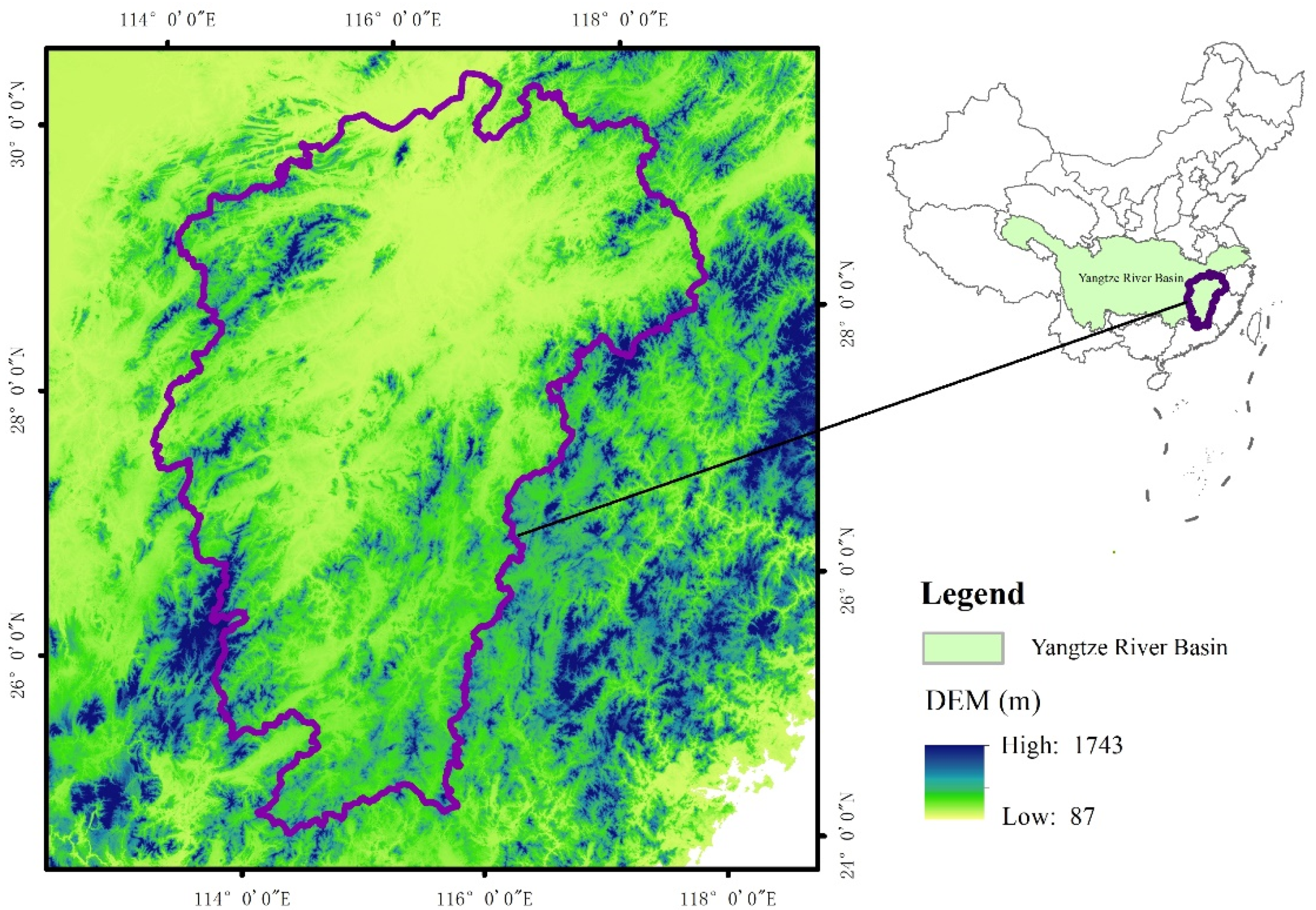
The results of the evolution of ETFP show the great differences among counties (as well as cities and districts) in the study area. However, the cause of the differences remains unclear and the best way to improve the ETFP remains a contentious point. Thus quantitative research is discussed in this section to analyze the influencing factors affecting ETFP. The results would provide a theoretical basis for promoting the coordinated development of grain production and environmental protection. In view of the spatial flow of grain production factors and the spatial effect of production in different counties, the spatial econometric model was adopted, which can effectively capture the spatial effect and elucidate its rules when discussing the influencing factors affecting ETFP.

3.2.1. Variable Selection and Description

According to the framework structure of the evaluation of the ETFP and the principle of efficiency measurement, increasing grain outputs, reducing agricultural non-point source pollution redundancy, and lowering input redundancy are the main ways to improve the ETFP. The relevant literature on the influencing factors on ETFP indicates that the possible factors include: spatial and geographical factors, the urbanization rate, average annual temperature, average annual precipitation, multiple-crop index, industrial agglomeration, the average business scale per worker, the proportion of grain-growing population, fiscal policies for supporting agriculture, the total power of agricultural machinery per unit area, and the proportion of the grain sown area. The details of these factors are as follows:
Urbanization rate. This reflects the process and extent of population moving to cities. Referring to the practice of [52] and [53], the proportion of urban population to total population was used as the urbanization index in this paper. Considering the availability and accessibility of permanent population data, the urbanization rate based on the registered residence was adopted. To alleviate the heteroscedasticity phenomenon, the urbanization rate was used under logarithmic processing, represented by lnUr.
Natural environmental factors. Grain production is sensitive to natural environmental changes and the deterioration of ecological environment certainly affects grain production efficiency [54]. Therefore, the annual mean temperature and annual mean precipitation were selected for this study. These meteorological data were preprocessed for spatial interpolation by ARCMAP 10.8. To alleviate the heteroscedasticity phenomenon, annual mean temperature and annual mean precipitation were processed by logarithmic operations, and then represented by lnT and lnRf, respectively.
Multiple-crop index. This was represented by dividing the total sown area of crops in a county by the area of cultivated land. To alleviate the heteroscedasticity phenomenon, multiple-crop index was processed by using a logarithmic operation, and then represented by lnMci.
Industrial agglomeration. Location entropy was adopted to measure the degree of grain industry agglomeration. The calculation formula is as follows:
I a i m = Q i m / Q i Q m / Q  
where I a i m refers to the location entropy index of grain industry m in i county. Q i m refers to the total value of output of grain industry in i county. Q i refers to the total value of output of the agricultural industry in i county. Q m refers to the total value of output of the grain industry minus the output in Poyang Lake Basin. Q refers to the total value of output of the agricultural industry in Poyang Lake Basin. If I a i m is more than 1, then the degree of grain agglomeration in i county is higher, indicating that the specialization degree of grain in this county exceeds the average level in Poyang Lake Basin as a whole. If I a i m is smaller than 1, then the degree of grain agglomeration in i county is lower, indicating that the specialization degree of grain in this county is lower than the average level in Poyang Lake Basin as a whole. To alleviate the heteroscedasticity phenomenon, industrial agglomeration was processed by a logarithmic operation, which is represented by lnIa.
Average business scale per worker. This reflects the average ability per grain-planting labor force to engage in grain production, which is represented by dividing the grain sowing area of a county by its grain-planting labor force. The grain-planting labor force was represented by the number of employees in the primary industry multiplied by the sown area of grains/the sown area of crops. To alleviate the heteroscedasticity phenomenon, the average business scale per worker was processed by a logarithmic operation, which did not affect the co-integration relationship among variables but did eliminate the difference between the average business scale per worker and the explained variables in various dimension, represented by lnAls.
Proportion of the grain-growing population. This was represented by dividing the grain-growing population in a county by its total population; the grain-planting labor force was represented by the number of employees in primary industries multiplied by the sown area of grains/the sown area of crops. To alleviate the heteroscedasticity phenomenon, the proportion of grain-growing population was processed by using a logarithmic operation, which is represented by lnPgpp.
Fiscal policies for supporting agriculture. The local fiscal policies for supporting agriculture are very important for grain production. The proportion of agriculture related expenditure of each country to total fiscal expenditure is used to represent the fiscal policies for supporting agriculture on the basis of the existing literature research. The fiscal expenditure for supporting agriculture is represented by the total amount of the expenditure on supporting rural production, while the total fiscal expenditure is the general budgetary expenditure. To alleviate the heteroscedasticity phenomenon, fiscal policies for supporting agriculture were processed by a logarithmic operation, which is represented by lnFsap.
Total power of agricultural machinery per unit area. This was represented by dividing the total power of agricultural machinery in a county by the sown area of crops. To alleviate the heteroscedasticity phenomenon and eliminate the difference between the absolute value of total power of agricultural machinery per unit area and the explained variable in dimensions, the total power of agricultural machinery per unit area was obtained through logarithmic processing, which is represented by lnTpampua.
Proportion of grain sown area. This was represented by dividing the sown area of grains in a county by the sown area of crops. Under logarithmic processing, it is represented by lnPgsa.
The above data came from the statistical yearbooks of cities in Jiangxi Province over relevant years and the statistical bulletins on the national economic and social development of counties.

3.2.2. Multiple Commonality Test of Variables

In order to avoid a high correlation between explanatory variables in the regression model, which leads to model estimations being distorted or inaccurate, multiple collinearity tests were carried out on the explanatory variables of the urbanization rate, average annual temperature, average annual precipitation, multiple-crop index, industrial agglomeration, average business scale per worker, proportion of grain-growing population, fiscal policies for supporting agriculture, total power of agricultural machinery per unit area, and proportion of the grain sown area. The results are shown in Table 2, in which the correlation between fiscal policies for supporting agriculture and proportion of the grain-growing population is the largest (0.4400). Generally speaking, the closer the correlation coefficient of two explanatory variables is to 1.0000, the stronger the correlation is. From the correlation coefficient between the explanatory variables in the Table 2, there is no obvious multiple collinearity problem between the explanatory variables.

3.2.3. Stability Test of Variables

Table 3 shows that when the significance value of each variable was tested, the results showed that the first order difference of all variables passed the five panel unit root tests of the ADF-Fisher test, PP-Fisher test, IPS test, Breitung test, and LLC test at the significance level of 1%. It can be seen that the influencing factors of total factor productivity are all first order single integral sequences, which can be used for quantitative regression analysis of each panel data sequence.

3.2.4. Spatial Panel Model Test and Model Selection

In order to select a reasonable spatial measurement model, two steps needed to be completed before the empirical analysis of a spatial panel; the first involved assessing whether the panel regression model is a fixed effect or random effect model; for the second, on the basis of step 1, the appropriate spatial panel model needed to be selected (a spatial panel autoregressive model or a spatial panel error model).
Table 4 lists the Hausman test results of the spatial panel autoregressive model (SAR model) and the spatial panel error model (SEM model) of ETFP. The statistical values of the Hausman test from the SAR and SEM models were 25.5700 and 25.6300, respectively. These two results passed the significance test at a 1% level. Based on the above analysis, we can see that the ETFP rejected the original hypothesis (the P value is greater than 0.05), which indicates that the spatial measurement model with fixed effects is more suitable.
Based on the fixed effect spatial measurement model, the LMSAR, LMSEM, Robust LMSAR, and Robust LMSEM tests were adopted for the SAR and SEM models. The results are shown in Table 5, which include the test results of the Moran’s I indices, the Lagrange Multiplier (LM), and Robust Lagrange multiplier (Robust LM) of the SAR and SEM model. The results show that the ETFP Moran’s I index was 21.5350, and at the 1% level, this explains why the ETFP has a spatial effect. LMSAR results were 442.9880 at the 1% level, while LMSEM results were 431.2340, and passed the significance test at the 1% level. Robust LMSAR results were 12.7520 at the 1% level, Robust LMSEM statistics were 0.9980 and the significance level was 31.80. It can be seen that the SAR model is more robust than the SEM model. Therefore, it was more appropriate to construct a SAR model.

3.2.5. The Estimated Results of Spatial Panel Model

Spatial panel model estimation was conducted to determine the influencing factors of ETFP by using Stata15.0 Tools. Table 6 shows the estimated regression results of spatial panel regression model for the ETFP based on a spatial adjacency weight matrix. Models I, II, III, and IV in the table were based on no fixed, spatial fixed, time fixed, and time-space bidirectional fixed effects of the spatial panel.
From the perspective of the regression coefficient of model explanatory variables, most of the regression coefficients of explanatory variables in Model II (the space fixed effect model) passed the significance test. In general, Model II was better than Model III (the time fixed effect model) and Model IV (the time-space bidirectional fixed effect model). In addition, the AIC and BIC values of Model II were lower than those of Models III and IV, and the R2 of Model II was higher than those of Models III and IV. The significant differences existed in the ETFP among counties. If the differences among counties are ignored, then the estimated results cause an obvious deviation. In the spatial panel autoregressive model, it was assumed that all counties (cities and districts) have the same level of ETFP to Model I (no fixed effect model), which obviously ignores the regional differences of ETFP. For Model III (time fixed effect model), the influence of time was considered, but the influence of the regional difference of ETFP was also ignored, and the estimated results also caused a different deviation. In terms of Model IV (the bidirectional fixed effect model), the influence of the regional differences on the ETFP and the influence of time were considered, thereby theoretically avoiding the deviations caused by time and regional differences. However, based on the spatial econometric estimated results in Table 2, the AIC and BIC values of Model IV were higher than those of Model II, and the R2 of Model IV was lower than that of Model II. This finding indicates that Model IV is inferior to Model II, which may be due to the fact that the time fixed effect affects the ETFP in the current period and has a radiation influence on other periods. Under the background of regional differences, the estimated result of the bidirectional fixed effect model was not better than that of the space fixed effect model. Based on the above analysis, choosing a spatial panel autoregressive model (Model II) with fixed effect is more appropriate.

3.2.6. Robustness Test of the SAR Model

In order to verify the applicability of selected spatial weight, it was necessary to further test the robustness of the spatial metrological regression results. The regression coefficient and significance of each factor were investigated based on the spatial weight matrix to determine whether the results were robust when the geospatial weight matrix and economic spatial weight matrix were adopted, respectively. After standardizing the two weights, the regression analysis of the spatial adjacency weight matrix, geographic distance spatial weight matrix, and economic distance spatial weight matrix was carried out, respectively, and the results were model I, model II, and model III (Table 7). The sign direction of the regression coefficient of model II and model III was completely consistent with the results of model I, and the magnitude of regression coefficient was relatively stable, while the level of significance was basically unchanged. These results show that the spatial effect of the main influencing factors on the ETFP remained stable, and there was no great difference due to the different selection of the spatial weight matrix. Therefore, the measurement and estimation results of the SAR model based on fixed effects are robust.

3.2.7. Analysis on the Estimated Results of Spatial Panel Model

Analysis of Measurement Results of Spatial Autoregressive Coefficient

In recent years, some scholars have started to focus on the spatial effect on the field of grain production, and they agree that the spatial and geographical factors have an important effect on the ETFP of grain production [55]. According to the spatial panel autoregressive results with a fixed effect, the estimated value of spatial autoregressive coefficient ρ of the ETFP is 0.5817 and passes the significance test at 1% level. The spatial correlation coefficient reveals that geographical factors are positive and pass the significance probability test. This further verifies the rationality of choosing a spatial measurement model instead of the traditional panel data model used in this paper. A spatial dependence exists on the ETFP among neighboring counties: the ETFP is closely related to the urbanization rate, fiscal policies for supporting agriculture, and the proportion of the grain-growing population. It also depends on the ETFP level in neighboring counties with similar spatial characteristics to a certain extent. A mutual positive impact was found on the level of the ETFP among counties. The spatial mobility of the ETFP increases with deepening agricultural marketization. Accordingly, the relationship between different counties in terms of grain production is becoming increasingly close, and the mutual dependence of ETFP in neighboring counties is becoming more obvious.

Analysis of Measurement Results of Influencing Factors

Based on the measurement estimated results of spatial panel autoregressive model with fixed effects (Table 2), the factors influencing the ETFP were analyzed as follows:

Urbanization Rate

The value of urbanization rate was −0.0027, indicating that the influence of the urbanization rate on ETFP is negative. On the premise that other conditions remain unchanged, if the urbanization rate increases by one percent, then the ETFP will decrease by 0.0027 percent. This result may be due to the fact that the rapid growth of the economy and the improvement of the population urbanization rate change the demographic structure of the rural labor force. The employment opportunities, remuneration for labor, and living conditions in urban areas are significantly higher than those in rural areas; thus, the young and middle-aged labor force from rural areas is more willing to stay in cities. The people who stay in rural areas are the elderly, women, and children, meaning the structure of the labor force engaged in grain production have an aging or tender constitution. Considering both the age and knowledge structures of the remaining rural labor force engaged in grain production, modern agricultural development does not fully meet its needs. This phenomenon is manifested in the serious aging, low scientific quality, and unclear understanding of agricultural non-point source pollution. Most of the remaining rural labor force still maintains a traditional extensive mode of grain production, which is not conducive to the promotion and application of new technologies and new concepts. This fact will aggravate the degree of unreasonable utilization of resources and the damage to the environment, which will hinder the development of grain production and is not conducive to the improvement of the ETFP.

Natural Environment Factors

Grain production is the most sensitive and the most vulnerable agricultural area affected by climate change in the natural environment, and it is closely related to climatic conditions. The grain production environment is affected by climate changes, such as in temperature and precipitation, the impact of which varies with time and space [56]. The impact of climate change on grain production includes the input and output of grain production factors, which leads to the change of ETFP.
From the regression results of the spatial autoregressive model with fixed effect shown in Table 2, the coefficient of average annual temperature is shown to be 0.1197, indicating that the impact of the average annual temperature on the ETFP is positive. On the premise that other conditions are unchanged, if the average annual temperature increases by one percent, then the ETFP will increase by 0.1197 percent, and the average annual temperature significantly affects the ETFP at a 10% level. Based on the original data, the average annual temperature in Poyang Lake Basin is 18 °C, and the interannual variation shows a slowly rising trend. In general, the climate is suitable for and conducive to the growth of grain. The climate promotes the improvement of the ETFP. The coefficient of average annual precipitation was found to be −0.0086, indicating that the impact of average annual precipitation on the ETFP is negative. On the premise that other conditions remain unchanged and if the average annual rainfall increases by one percent, then the ETFP will decrease by 0.0086 percent, and the average annual precipitation will significantly affect the ETFP at the 5% level. The average annual precipitation in Poyang Lake Basin is above 1000 mm, and the interannual precipitation fluctuates greatly and frequently. Too much precipitation is not conducive to the improvement of the ETFP to a certain extent.

Multiple-Crop Index

The coefficient of multiple-crop index was found to be 0.0048, indicating that the impact of multiple-crop index on the ETFP is positive. The multiple-crop index is no longer being restricted by soil, moisture, and chemical fertilizer due to the technical progress of grain production and the improvement of management measures. Consequently, the utilization potential of cultivated land is tapped, and the land productivity is improved [57], which is conducive to the improvement of the ETFP.

Industrial Agglomeration

The coefficient of industrial agglomeration was found to be 0.0295, indicating that the impact of industrial agglomeration on the ETFP is positive. Industrial agglomeration significantly affects the ETFP at the 5% level. This finding indicates that the influence effect of industrial agglomeration on the ETFP is positive under certain conditions. Namely, if the level of industrial agglomeration is high, then the ETFP is also high. This finding may be due to the fact that great importance was attached to the agricultural non-point source of pollution in recent years, which has greatly reduced the use of pesticides and chemical fertilizers. Consequently, the environmental quality improves, which slows down the undesirable output redundancy to a certain extent. The industrial agglomeration provides advanced production technology and causes a technology diffusion effect, which is conducive to the improvement of ETFP.

Average Business Scale per Worker

The coefficient of the average business scale per worker was found to be 0.0652, indicating that the impact of average business scale per worker on the ETFP is positive. The average business scale per worker significantly affects the ETFP at the 1% level. This indicates that the influence effect of average business scale per worker on the ETFP is positive under certain conditions. The result may be due to the fact that the agricultural mechanization level adapts to the expansion of the average business scale per worker, which promotes the improvement of local agricultural modernization, is conducive to the reasonable allocation of grain production factors, reduces the waste of costs and negative externality caused by environmental pollution, and improves the ETFP.

Proportion of Grain-Growing Population

The coefficient of proportion of grain-growing population was found to be 0.0535, indicating that the impact of the proportion of grain-growing population on the ETFP is positive. The proportion of grain-growing population significantly affects the ETFP at 1% level. Based on the original data, the proportion of grain-growing population showed a slowly declining trend in 2001–2017. Theoretically, the ETFP needs to be reduced. However, due to the continuous development of agricultural modernization and the continuous improvement of agricultural socialized service system, the scale of grain planting and the mechanization level in the region are enhanced. Such enhancement makes up for the shortage of rural labor force and reduces the negative external level of environment, which in turn enhances the ETFP.

Fiscal Policies for Supporting Agriculture

The coefficient of fiscal policies for supporting agriculture was found to be 0.0067; as mentioned in the previous analysis framework, the government’s financial support policy changes the relative prices of agricultural products and means of food production, thereby showing a positive impact on peasants’ production behavior. For example, with the strong support of fiscal policies for supporting agriculture, the infrastructure for agricultural production has continuously improved, and the funds for agricultural scientific research, agricultural scientific and technological achievement transformations, subsidies for growing superior grain cultivators, and policy subsidies for agricultural products have increased yearly to provide good production conditions for grain production. These good production conditions are as follows: an increase in the relative prices of agricultural products and reduction in the relative prices of means of grain production; improvement in villager incomes and mobilization of their enthusiasm for grain production; provision of guidance to villagers to reasonably adjust the structure and quantity of the chemical factor input in agriculture; promotion of the coordinated development of grain economy and environment; and improvement of the ETFP.

Total Power of Agricultural Machinery per Unit Area

The coefficient of total power of agricultural machinery per unit area was found to be 0.0029, This phenomenon may be due to the fact that the northern area of Jiangsu is relatively flat with concentrated cultivated land, which allows agricultural mechanization. Consequently, it facilitates the improvement of the scale management level of cultivated land, and it is conducive to a loose soil structure and the absorption of nutrients by crops to reduce the negative environmental externality caused by chemical fertilizer. However, this area is surrounded by mountains in the eastern, western, and southern sides, and the central hills are undulating, while there is serious land fragmentation and a relatively low scale level, which hinder the development of agricultural mechanization. The total power of agricultural machinery per unit area has a positive promoting effect on the ETFP, but such an effect is not significant. Therefore, combined with the situation of grain production and land topography, solving the problem of land fragmentation is a way to improve the level of agricultural mechanization and is also an important way to improve the ETFP.

Proportion of Grain Sown Area

The coefficient of the proportion of grain sown area was found to be 0.0621, and the proportion of grain sown area significantly affects the ETFP at the 5% level. This finding may be due to the fact that if the proportion of grain sown area is larger, then it will facilitate the large-scale production of grain, which is conducive to the gradual improvement of the grain production environment and the reasonable utilization of resources. For example, the large-scale production of grain helps to improve agricultural mechanization, optimize the construction of irrigation infrastructure, and improve the effective irrigation rate in grain production. At the same time, the application amount of pesticide and chemical fertilizer is greatly reduced. Consequently, the standard emissions of input factors and agricultural non-point source pollution in grain production are lowered, which allows the improvement of ETFP.

4. Discussion

The main approaches to measuring the total factor productivity of grain production include the parametric method and non-parametric method. Among them, parameter method is applied to measure production efficiency by constructing the production frontier function. In general, the parameter method used to measure total factor productivity is Stochastic Frontier Analysis (SFA). Currently, this method has been commonly adopted to measure the total factor productivity of grain production [58,59]. Since the method (such as the production function method and the stochastic production frontier method) is required to set the specific form of production function, and given the risk of making errors in setting the specific production function, the non-parametric method removes the need to set a specific function form, which makes it advantageous over the parametric method. Besides, the prospect of making errors in the calculation result due to the selection of the wrong production function can be avoided. With regard to the total factor productivity evaluation of grain production, non-parametric methods have been extensively applied [8,60]. Some scholars adopted the above-mentioned methods to measure the total factor productivity of grain production, which led to the argument that there is still no consensus that has been reached on the main reasons behind the changes in the total factor productivity of grain production [61,62]. Allowing for this, agricultural non-point source pollution was introduced in this study into the analytical framework applied to the total factor productivity of grain production, and Malmquist-Luerberger index was adopted to measure the total factor productivity of a grain production environment in Poyang Lake Basin. As indicated by the results, the changes in total factor productivity of grain production environment in Poyang Lake Basin were determined by environmental technical efficiency and environmental technological progress during the period from 2001 to 2017. Moreover, the spatial autoregressive model was applied to explore the influencing factors in the total factor productivity of the grain production environment in Poyang Lake Basin, which led to the finding about the mechanism followed by the influencing factors in the total factor productivity of grain production environment in Poyang Lake Basin. It is of much practical significance to optimize the spatial layout of grain production for ensuring food security. Besides the urbanization rate and average annual precipitation, the influencing factors that have a negative effect on ETFP are the multiple-crop index, industrial agglomeration, average business scale per worker, proportion of grain-growing population, fiscal policies for supporting agriculture, total power of agricultural machinery per unit area, and the proportion of the grain sown area. However, there is still room to further this study. Firstly, it is necessary to subdivide the grain structure and conduct a study on the level of total factor productivity of the production environment for different varieties of grain. Due to constraints such as manpower, time, and statistical data, this study focused on grain as a whole, which led to the lack of attention paid to specific grain varieties such as rice, corn, wheat, and so on. Secondly, the influencing factors in total factor productivity of grain production environment were analyzed from macro and micro perspectives. On the basis of grain production practices, as well as the related theories and academic research, the corresponding indicators were selected in this study to analyze the influencing factors in total factor productivity of a grain production environment from a macro point of view, with no micro-level investigation conducted. Through a study carried out on the total factor productivity of grain production environment from both macro and micro perspectives, not only can the suggestions on how to improve the level of total factor productivity of the overall grain production environment in the region be made, but it is also possible to formulate more targeted policies from the perspective of practitioners.

5. Conclusions

The evolution and influencing factors of ETFP in Poyang Lake Basin in 2001–2017 are analyzed in this paper. In general, ETFP shows an overall growth trend in 2001–2017 and has a great potential to improve. Moreover, from the perspective of time sequence evolution and decomposition of ETFP, the ETFP is driven by environmental technical efficiency and environmental technological progress in dual tracks. This finding shows that the keys to improving ETFP were the technical efficiency of grain production environment and the coordinated development of environment and grain production. The urbanization rate and average annual precipitation have negative effects on the ETFP, whereas other explanatory variables have positive effects. Among the variables, the average business scale per worker and the proportion of the grain growing population significantly affect the ETFP at the 1% level; average annual rainfall, industrial agglomeration, and proportion of grain sown area significantly affect the ETFP at the 5% level; finally, the average annual temperature significantly affects the ETFP at the 10% level.
According to the findings of this paper, several policy implications can be mentioned:
Firstly, the infrastructure construction and the mechanization of grain production should be improved. Infrastructure is the key factor affecting the input of grain production factors. The study area is composed of mountains with a high terrain around them and a low terrain in the middle. The terrain is inclined from the outside to the inside, and it is composed of five tributaries. The climate is mild with sufficient sunshine, and this area is rich in light energy resources and has a relatively high amount of precipitation and plenty of water resources, though the spatial and temporal distributions are uniform. Thus optimizing the grain production infrastructure is very important. Firstly, considering the restrictions of the terrain conditions, the construction of water conservancy infrastructure, such as low-pressure irrigation and sprinkling irrigation and other facilities constructed for irrigation ditches and farmland, needs to be strengthened in the mountainous areas where grain production is conducted. Secondly, flood and drought events are frequent in the study area. Therefore, the continuous improvement of modern facilities, such as transportation and communication, is conducive to flood control and drought resistance. Moderately improving the mechanization of grain production can effectively replace the labor force in a mechanized operation mode, gradually increase the utilization rate of machinery in mountainous areas, promote the development of agricultural machinery, and accelerate the change of traditional grain production mode, thereby improving the ETFP.
Thirdly, to adjust the structure of grain production and reduce agricultural non-point source pollution. Based on the influence of different grain structures on fertilizer non-point source pollution, the planting area of grain with large fertilizer consumption needs to be reduced appropriately. By continuously improving the utilization rate of chemical fertilizer and straw incorporation and increasing the application of organic fertilizer, nutrient loss and pollution can be reduced. According to the relevant policies and technical standard, and based on the actual situation of areas, fertilizer non-point source pollution prevention and control policies in line with the local situation are formulated, and the relevant laws and regulations on the use of chemical fertilizer are improved. Consequently, the local villagers’ behavior was continuously regulated, the amount of fertilizer input was controlled, meaning that the level of fertilizer input could reduce the chemical fertilizer non-point source pollution.
Fourth, the cross regional exchange and cooperation should be strengthened, as it could effectively improve the ETFP and ultimately achieve the best ETFP with the same efficiency value in the region. From the perspective of the long term development of ETFP, the governments need to break the traditional administrative and regional barriers, conduct overall planning, and set up a cross county environmental cooperation mechanism and pollution compensation system to provide a good external environment for cross county exchange and cooperation. In addition, the governments need to actively promote the exchanges and cooperation of cross regional economic and technological development, as well as guide the flow of advanced technology, high technology talent, and excellent management modes to relatively backward regions. Doing all of the above mentioned actions would promote the rapid increase of ETFP, and form a virtuous circle of win–win cooperation, thereby coordinating the growth rate of ETFP in different regions.

Author Contributions

B.B.: Data curation, Formal analysis, Funding acquisition. A.J.: Conceptualization, Methodology, Formal analysis, Writing Original draft, Writing review & editing, Project administration. S.J.: Methodology, Validation, Writing review & editing. R.Z.: Formal analysis, Writing review & editing. All authors have read and agreed to the published version of the manuscript.

Funding

This research was funded by the Fundamental teaching research project of Anhui University of Finance and Economics, grant number acjyyb2020109; China Postdoctoral Science Foundation (2020M670609).

Institutional Review Board Statement

Not applicable.

Informed Consent Statement

Not applicable.

Data Availability Statement

Not applicable.

Conflicts of Interest

The authors declare no conflict of interest.

References

  1. Wei, H.K. Ten cutting-edge research topics on agriculture, rural areas and farmers. Chin. Rural Econ. 2019, 4, 2–6. [Google Scholar]
  2. Wu, Y.S. The construction of agricultural ecological environment is the basis for the transformation of agricultural develop-ment mode. Rural Econ. 2011, 2, 104. [Google Scholar]
  3. Battese, G.E.; Coelli, T.J. Frontier production functions, technical efficiency and panel data: With application to paddy farmers in India. J. Prod. Anal. 1992, 3, 153–169. [Google Scholar] [CrossRef]
  4. Odeck, J. Measuring technical efficiency and productivity growth: A comparison of SFA and DEA on Norwegian grain production data. Appl. Econ. 2007, 39, 2617–2630. [Google Scholar] [CrossRef]
  5. Wang, C.; Wu, J.X. Research on the production technology efficiency and its influencing factors of China’s corn industry—Based on the provincial panel data from 2001 to 2011. Chin. J. Agric. Resour. Reg. Plan. 2015, 36, 23. [Google Scholar] [CrossRef]
  6. Shahzad, M.A.; Razzaq, A.; Aslam, M.; Gulzar, M.F.; Naseer, M.A.U.R.; Nisar, N. Measuring Technical Efficiency of Wheat Farms in Punjab, Pakistan: A Stochastic Frontier Analysis Approach. J. Agric. Stud. 2019, 7, 115–127. [Google Scholar] [CrossRef] [Green Version]
  7. Coelli, T.; Rahman, S.; Thirtle, C. Technical, Allocative, Cost and Scale Efficiencies in Bangladesh Rice Cultivation: A Non-parametric Approach. J. Agric. Econ. 2002, 53, 607–626. [Google Scholar] [CrossRef]
  8. Endres, M.; Espejo, L. Erratum to Feeding management and characteristics of rations for high-producing dairy cows in freestall herds. J. Dairy Sci. 2010, 93, 1785–1786. [Google Scholar] [CrossRef] [Green Version]
  9. Ray, S.C.; Ghose, A. Production efficiency in Indian agriculture: An assessment of the post green revolution years. Omega 2014, 44, 58–69. [Google Scholar] [CrossRef]
  10. Boussemart, J.-P.; Leleu, H.; Ojo, O. The Spread of Pesticide Practices among Cost-Efficient Farmers. Environ. Model. Assess. 2013, 18, 523–532. [Google Scholar] [CrossRef]
  11. Minh, N.; Hung, N.; Hoa, H.; Khanh, P. FDI and Efficiency Convergence, the Case of Vietnamese Manufacturing Industry. Br. J. Econ. Manag. Trade 2015, 5, 172–180. [Google Scholar] [CrossRef]
  12. Chung, Y.; Färe, R.; Grosskopf, S. Productivity and Undesirable Outputs: A Directional Distance Function Approach. J. Environ. Manag. 1997, 51, 229–240. [Google Scholar] [CrossRef] [Green Version]
  13. Blancard, S.; Boussemart, J.-P.; Briec, W.; Kerstens, K. Short- and Long-Run Credit Constraints in French Agriculture: A Directional Distance Function Framework Using Expenditure-Constrained Profit Functions. Am. J. Agric. Econ. 2006, 88, 351–364. [Google Scholar] [CrossRef]
  14. Singbo, A.G.; Lansink, A.O. Lowland farming system inefficiency in Benin (West Africa): Directional distance function and truncated bootstrap approach. Food Secur. 2010, 2, 367–382. [Google Scholar] [CrossRef] [Green Version]
  15. Watto, M.A.; Mugera, A.W. Measuring Production and Irrigation Efficiencies of Rice Farms: Evidence from the Punjab Province, Pakistan. Asian Econ. J. 2014, 28, 301–322. [Google Scholar] [CrossRef]
  16. Kokic, P.; Davidson, A.; Boero, R.V. Australia’s grains industry: Factors influencing productivity growth. Austr. Commod. Forecast. Issues 2006, 13, 705. [Google Scholar]
  17. Guyomard, H.; Latruffe, L.; Le, M.C. Technical efficiency, technical progress and productivity change in French agriculture: Do subsidies and farms’ size matter. In Proceedings of the 96th Seminar of the European Association of Agricultural Economists, Tänikon, Switzerland, 10–11 January 2006. [Google Scholar]
  18. Armagan, G.; Ozden, A.; Bekcioglu, S. Efficiency and total factor productivity of crop production at NUTS1 level in Turkey: Malmquist index approach. Qual. Quant. 2008, 44, 573–581. [Google Scholar] [CrossRef]
  19. Wouterse, F. Migration and technical efficiency in cereal production: Evidence from Burkina Faso. Agric. Econ. 2010, 41, 385–395. [Google Scholar] [CrossRef] [Green Version]
  20. Rahman, S. Profit efficiency among Bangladeshi rice farmers. Food Policy 2003, 28, 487–503. [Google Scholar] [CrossRef] [Green Version]
  21. Zhang, Q.; Xiao, H.; Duan, M.; Zhang, X.; Yu, Z. Farmers’ attitudes towards the introduction of agri-environmental measures in agricultural infrastructure projects in China: Evidence from Beijing and Changsha. Land Use Policy 2015, 49, 92–103. [Google Scholar] [CrossRef]
  22. Rada, N.E.; Buccola, S.T. Agricultural policy and productivity: Evidence from Brazilian censuses. Agric. Econ. 2012, 43, 355–367. [Google Scholar] [CrossRef] [Green Version]
  23. Lu, Y.; Gao, Y.; Jia, J.J. C and N Transport Flux and Associated Changes of Water Quality Parameters from a Multiscale Subtrop-ical Watershed in the Poyang Lake Area. Environ. Sci. 2019, 40, 2696. [Google Scholar] [CrossRef]
  24. Zeng, Y.; Li, S.; Hu, Y.B. Spatial-Temporal Variation of Distribution of Rainfall Erosivity in the Poyang Lake Basin during 1961–2014. J. Ecol. Rural Environ. 2019, 35, 106–114. [Google Scholar] [CrossRef]
  25. Jiangxi Provincial Bureau of Statistics. Jiangxi Statistical Yearbook; China Statistics Press: Jiangxi, China, 2002; Available online: https://navi.cnki.net/KNavi/YearbookDetail?pcode=CYFD&pykm=YJXTJ&bh (accessed on 15 July 2003).
  26. Nanchang Bureau of Statistics. Nanchang Statistical Yearbook; China Statistics Press: Nanchang, China, 2002; Available online: https://navi.cnki.net/knavi/YearbookDetail?pcode=CYFD&pykm=YJXNC (accessed on 15 July 2003).
  27. Jiujiang Bureau of Statistics. Jiujiang Statistical Yearbook; China Statistics Press: Nanchang, China, 2002; Available online: https://navi.cnki.net/knavi/YearbookDetail?pcode=CYFD&pykm=YJJJJ (accessed on 15 July 2003).
  28. Jingdezhen Bureau of Statistics. Jingdezhen Statistical Yearbook; China Statistics Press: Jingdezhen, China, 2016; Available online: https://navi.cnki.net/knavi/YearbookDetail?pcode=CYFD&pykm=YJDZT (accessed on 15 July 2017).
  29. Shangrao Bureau of Statistics. Shangrao Statistical Yearbook; China Statistics Press: Jingdezhen, China, 2002; Available online: https://navi.cnki.net/knavi/YearbookDetail?pcode=CYFD&pykm=YZHCT (accessed on 15 July 2003).
  30. Yingtan Bureau of Statistics. Yingtan Statistical Yearbook; China Statistics Press: Yingtan, China, 2017; Available online: https://navi.cnki.net/knavi/YearbookDetail?pcode=CYFD&pykm=YTTJJ (accessed on 15 July 2018).
  31. Fu Zhou Bureau of Statistics. Fu zhou Statistical Yearbook; China Statistics Press: Fuzhou, China, 2016; Available online: https://navi.cnki.net/knavi/YearbookDetail?pcode=CYFD&pykm=YFUZH (accessed on 15 July 2017).
  32. Ji’an Bureau of Statistics. Ji’an Statistical Yearbook; China Statistics Press: Ji’an, China, 2016; Available online: https://navi.cnki.net/knavi/YearbookDetail?pcode=CYFD&pykm=YJATJ (accessed on 15 July 2017).
  33. Xinyu Bureau of Statistics. Xinyu Statistical Yearbook; China Statistics Press: Xinyu, China, 2017; Available online: https://navi.cnki.net/knavi/YearbookDetail?pcode=CYFD&pykm=YXXTN (accessed on 15 July 2018).
  34. Yichun Bureau of Statistics. Yichun Statistical Yearbook; China Statistics Press: Yichun, China, 2008; Available online: https://navi.cnki.net/knavi/YearbookDetail?pcode=CYFD&pykm=YYCTJ (accessed on 15 July 2009).
  35. Ban, L.; Yuan, X.L. Differences and Spatial Influence Mechanism of Green Economic Efficiency between China’s Eight Regions. J. Xi’an Jiaotong Univ. 2016, 36, 22. [Google Scholar] [CrossRef]
  36. Tao, J.H.; Shi, P. Estimation of total factor productivity in Western China under environmental constraints—Based on Malmquist Luenberger index method. J. Commer. Econ. 2012, 128. [Google Scholar] [CrossRef]
  37. Ren, M.; Wang, X.M.; Liu, L. Spatiotemporal changes and influencing factors of environmental regulation efficiency in China’s coastal urban agglomerations. Sci. Geogr. Sin. 2019, 39, 1119–1128. [Google Scholar] [CrossRef]
  38. Whittle, P. On Stationary Processes in the Plane. Biometrika 1954, 41, 434. [Google Scholar] [CrossRef]
  39. Cressie, N.A.C. Statistics for Spatial Data, Revised Edition. Biometrika 1994, 50, 319. [Google Scholar] [CrossRef]
  40. Waller, L.A.; Gotway, C.A. Applied Spatial Statistics for Public Health Data; John Wiley & Sons: Hoboken, NJ, USA, 2004. [Google Scholar]
  41. Kissling, W.D.; Carl, G. Spatial autocorrelation and the selection of simultaneous autoregressive models. Glob. Ecol. Biogeogr. 2007, 17, 59–71. [Google Scholar] [CrossRef]
  42. Hooten, M.B.; Hanks, E.M.; Johnson, D.S.; Alldredge, M.W. Reconciling resource utilization and resource selection functions. J. Anim. Ecol. 2013, 82, 1146–1154. [Google Scholar] [CrossRef] [PubMed] [Green Version]
  43. Min, R.; Li, G.C. Grain’s Production Efficiency and Its Spatial Distribution in China from the “Two-oriented (Resource and Environment)” Perspective. Econom. Geogr. 2013, 33, 144. [Google Scholar]
  44. Zhang, L.G.; Bao, B.F.; Pan, D. Spatial-Temporal Evolution and Environmental Coordination of Technical Efficiency of Grain Production in Poyang Lake Eco-Economic Zone. Econom. Geogr. 2016, 36, 116. [Google Scholar] [CrossRef]
  45. Li, R.G.C. Growth and decomposition of green total factor productivity of grain in Hubei Province in the transitional period. J. Hubei Univ. 2014, 41, 137. [Google Scholar] [CrossRef]
  46. Xu, W.S.T. Environmental efficiency and its determinants regarding China’s grain production. Resour. Sci. 2016, 38, 52–63. [Google Scholar] [CrossRef]
  47. Fischer, G.; Winiwarter, W.; Ermolieva, T.; Cao, G.-Y.; Qui, H.; Klimont, Z.; Wiberg, D.; Wagner, F. Integrated modeling framework for assessment and mitigation of nitrogen pollution from agriculture: Concept and case study for China. Agric. Ecosyst. Environ. 2010, 136, 116–124. [Google Scholar] [CrossRef]
  48. Hou, M.Y.; Yao, S.B. Convergence and differentiation characteristics on agro-ecological efficiency in China from a spatial perspective. China Popul. Resour. Environ. 2019, 29, 116. [Google Scholar] [CrossRef]
  49. Wu, L.F. Study on Temporal-spatial Distribution of Agricultural Non-point Source Pollution in Poyang Lake Region. Acta Agricul. Jiangxi 2012, 24, 159. [Google Scholar] [CrossRef]
  50. Chen, Y.; Feng, Y.Z.; Yang, G.H. Verification of Environmental Kuznets curve of agricultural non-point source pollution in Shaanxi Province. J. Agrotech. Econom. 2010, 22, 34–42. [Google Scholar]
  51. Min, R.; Li, G.C. A Study on Growth and Decomposition of China’s Grain TFP Growth under Enivronmental Constrains: Empirical Analysis Based on Provincical Panel Data and Sequential Malmquist-Luenberger Index. Econom. Rev. 2012, 5, 34–42. [Google Scholar]
  52. Yu, F.L.; Huang, Z.F.; Cao, F.D. Influence of China’s Urbanization on Tourism Economic Development. J. Nat. Res. 2014, 29, 1297. [Google Scholar] [CrossRef]
  53. Zhang, Y.Z.; Hu, R.D. Research on the conduction effect of urbanization on economic growth in China—Based on state space model. Macroeconomics 2014, 5, 92. [Google Scholar]
  54. Marvin, H.J.; Kleter, G.A.; Van Der Fels-Klerx, H.; Noordam, M.Y.; Franz, E.; Willems, D.J.; Boxall, A. Proactive systems for early warning of potential impacts of natural disasters on food safety: Climate-change-induced extreme events as case in point. Food Control. 2013, 34, 444–456. [Google Scholar] [CrossRef]
  55. Li, J.P.; Feng, Z.C.; Wu, Q.H. Identification of Grain Production’s Technical Efficiency Growth Path: Direct Impact and Spillo-ver Effect. J. Huazhong Agric. Univ. 2018, 1, 22. [Google Scholar] [CrossRef]
  56. Ambardekar, A.A.; Siebenmorgen, T.J.; Counce, P.A.; Lanning, S.B.; Mauromoustakos, A. Impact of field-scale nighttime air temperatures during kernel development on rice milling quality. Field Crop. Res. 2011, 122, 179–185. [Google Scholar] [CrossRef]
  57. Li, L.F.; Li, M.G. Improving multiple cropping index is an effective way to ensure food security in China. Mod. Manag. 2012, 3, 26. [Google Scholar] [CrossRef]
  58. Tan, Y.; Guan, J.; Karimi, H.R. The Impact of the Subsidy Policy on Total Factor Productivity: An Empirical Analysis of China’s Cotton Production. Math. Probl. Eng. 2013, 2013, 1–8. [Google Scholar] [CrossRef] [Green Version]
  59. Arshad, M.; Amjath-Babu, T.; Aravindakshan, S.; Krupnik, T.J.; Toussaint, V.; Kächele, H.; Müller, K. Climatic variability and thermal stress in Pakistan’s rice and wheat systems: A stochastic frontier and quantile regression analysis of economic efficiency. Ecol. Indic. 2018, 89, 496–506. [Google Scholar] [CrossRef]
  60. Mukherjee, D.N.; Vasudev, N.; Vijaya Kumari, R. Nonparametric Estimation and Decomposition of Total Factor Productivity of Rice and Maize in Telangana State. Bull. Environ. Pharmacol. Life Sci. 2017, 6, 26–31. [Google Scholar]
  61. Wei, D.; Min, R.; Wang, Y.P. Technical Efficiency, Technical Progress and Grain Productivity Growth--an Empirical Analysis based on Provincal Panel Data in China. Forum Sci. Technol. China 2010, 140–145. [Google Scholar]
  62. Tejwani, A.; Ashamalla, H.; Guirguis, A.; Mattes, M.; Zaidi, A.; Mokhtar, B. The Anatomical Biological Value on Pretreatment18F-fluorodeoxyglucose Positron Emission Tomography Computed Tomography Predicts Response and Survival in Locally Advanced Head and Neck Cancer. World J. Nucl. Med. 2014, 13, 102–107. [Google Scholar] [CrossRef]
Figure 1. Sketch map of Poyang Lake Basin.
Land 10 00606 g001
Figure 2. The evolution of ETFP in Poyang Lake Basin in 2001–2017.
Land 10 00606 g002
Table 1. The value and decomposition of environmental total factor productivity (ETFP) in 2001–2017.
YearsML IndexMLEC IndexMLTC Index
20010.99981.05140.9509
20020.98111.03820.9450
20030.96871.03820.9331
20041.14080.97821.1662
20051.01131.01520.9962
20061.01860.99691.0218
20071.02151.02560.9960
20081.02480.97571.0504
20091.03520.95901.0794
20101.01081.06020.9534
20111.00000.93841.0656
20121.02011.02860.9917
20131.03001.00251.0275
20140.98151.04410.9401
20151.00260.95561.0492
20160.99931.00740.9920
20171.06150.98911.0733
Mean value1.01811.00611.0136
Note: ML: Malmquist Luerberger; MLEC: Environmental technical efficiency index; MLTC: Environmental technology progress index.
Table 2. Multiple commonality test of the influencing factors of total factor productivity.
VariableslnUrlnTlnPfelnMcilnIalnAlslnPgpplnRflnTpampualnPgsa
lnUr1.0000
lnT−0.07131.0000
lnRf0.1051−0.07221.0000
lnMci−0.15180.0987−0.03161.0000
lnIa−0.00820.05730.01040.11201.0000
lnAls0.3801−0.07570.10800.18530.18031.0000
lnPgpp−0.30170.3430−0.07620.02080.0398−0.40771.0000
lnFsap−0.02080.10760.00540.00030.18560.4400−0.14751.0000
lnTpampua0.19120.01570.0885−0.3995−0.1557−0.01510.23080.41441.0000
lnPgsa−0.07460.37860.0310−0.1422−0.0917−0.06720.41180.05250.10441.0000
Note: lnUr: Urbanization rate; lnT: annual mean temperature; lnPfe: annual mean precipitation; lnMci: Multiple-crop index; lnIa: Industrial agglomeration; lnAls: Average business scale per worker; lnPgpp: Proportion of grain-growing population; lnFsap: Fiscal policies for supporting agriculture; lnTpampua: Total power of agricultural machinery per unit area; lnPgsa: Proportion of grain sown area.
Table 3. Stability tests of the influencing factors of total factor productivity.
VariablesADF-Fisher TestPP-Fisher TestIPS TestBreitung TestLLC TestStability
lnUr−19.4908 ***−25.0045 ***−31.4256 ***−15.2963 ***−25.8143 ***Yes
lnT−17.6564 ***−18.8608 ***−21.6290 ***−8.2657 ***−18.8891 ***Yes
lnRf−8.7507 ***−10.4566 ***−10.2257 ***−10.6004 ***−7.1997 ***Yes
lnMci−22.8512 ***−30.1026 ***−27.3355 ***−21.8019 ***−33.9216 ***Yes
lnIa−21.7863 ***−29.3432 ***−33.8887 ***−19.9206 ***−34.0141 ***Yes
lnAls−12.7358 ***−16.0812 ***−30.5982 ***−16.9721 ***−16.6919 ***Yes
lnPgpp−22.0033 ***−28.5660 ***−32.9729 ***−23.8738 ***−28.9715 ***Yes
lnFsap−16.4022 ***−24.0724 ***−30.1142 ***−12.1593 ***−24.2702 ***Yes
lnTpampua−18.3670 ***−30.7438 ***−25.1761 ***−20.9095 ***−26.5262 ***Yes
lnPgsa−20.8611 ***−28.7829 ***−27.3656 ***−23.1546 ***−32.6967 ***Yes
Note: *** mean passing a significance test at 1% levels, respectively.
Table 4. Fixed and random effects test of a spatial panel model.
Hausman TestETFP
Statistics Valuep Value
SAR25.57000.0044
SEM25.63000.0043
Table 5. Spatial effects test of the SAR model and SEM model.
TestETFP
Statistics Valuep Value
Moran’s I21.5350 ***0.0000
LMSAR442.9880 ***0.0000
LMSEM431.2340 ***0.0000
Robust LMSAR12.7520 ***0.0000
Robust LMSEM0.9980 ***0.3180
Note: *** mean passing the significance test at 1% levels, respectively.
Table 6. Spatial econometric estimation results of ETFP based on the SAR model.
Variables Model IModel IIModel IIIModel IV
No Fixed EffectSpace Fixed EffectTime Fixed EffectBidirectional Fixed Effect
Regression CoefficientTRegression CoefficientTRegression CoefficientTRegression CoefficientT
LnUr−0.0027−0.4000−0.0027−0.4000−0.0081 *−1.6700−0.0115−1.6200
lnT0.02631.08000.1197 *1.7700−0.0293−1.18000.09911.0900
lnRf−0.0086 **−2.3400−0.0086 **−2.24000.00800.50000.00900.4800
lnMci0.00190.24000.00480.44000.00290.34000.00390.3300
lnIa0.00881.15000.0295 **2.04000.00831.12000.0337 **2.4000
lnAls0.00721.26000.0652 ***2.99000.0150 **2.45000.0706 ***2.8800
lnPgpp0.00780.99000.0535 ***2.20000.0149 *1.77000.0585 **2.1900
lnFsap0.00190.56000.00671.21000.00560.97000.0236 *1.8500
lnTpampua0.00290.61000.00290.61000.00400.98000.00340.5700
lnPgsa0.00800.59000.0621 **2.0200−0.0092 **0.62000.00530.1500
ρ0.6034 ***0.5817 ***0.06670.0725
R20.23300.43640.21540.3170
LogL1870.14701987.86621917.29521981.3320
AIC−3806.5904−3778.3980−3938.6640−3992.2220
BIC−3733.5770−3811.8150−3876.0810−3929.6390
Note: *, **, and ***mean passing a significance test at 10%, 5%, and 1% levels, respectively.
Table 7. The ETFP robustness test results based on spatial fixed effects.
VariablesModel IModel IIModel III
No Fixed EffectRobustness TestRobustness Test
Regression CoefficientTRegression CoefficientTRegression CoefficientT
LnUr0.0027−0.4000−0.0040−0.6000−0.0020−0.2800
lnT0.1197 *1.77000.1606 **2.29000.1565 **2.2300
lnRf−0.0086 **−2.2400−0.0144 *−1.6800−0.0145 *−1.6800
lnMci0.00480.44000.00360.32000.00200.1800
lnIa0.0295 **2.04000.0322 **2.15000.0315 **2.1000
lnAls0.0652 ***2.99000.0732 ***3.23000.0731 ***3.2200
lnPgpp0.0535 ***2.20000.0695 ***2.75000.0641 **2.5300
lnFsap0.00671.21000.00470.81000.00460.8000
lnTpampua0.00290.61000.00390.78000.00320.6400
lnPgsa0.0621 **2.02000.0684 **2.13000.0787 **2.4600
ρ0.5817 ***0.3519 ***0.2851 ***
R20.43640.25930.3169
LogL1987.86621901.19981900.1342
AIC−3778.3980−3778.3996−3776.2684
BIC−3811.8150−3715.8167−3713.6855
Note: Model I: the spatial adjacency weight matrix model; Model II: geographic distance spatial weight matrix model; Model III: economic distance spatial weight matrix model. *, **, and *** mean passing a significance test at 10%, 5%, and 1% levels, respectively.
Publisher’s Note: MDPI stays neutral with regard to jurisdictional claims in published maps and institutional affiliations.

