
Transformation of the Landscape in the Conditions of the Slovak Republic for Tourism


Abstract
1. Introduction
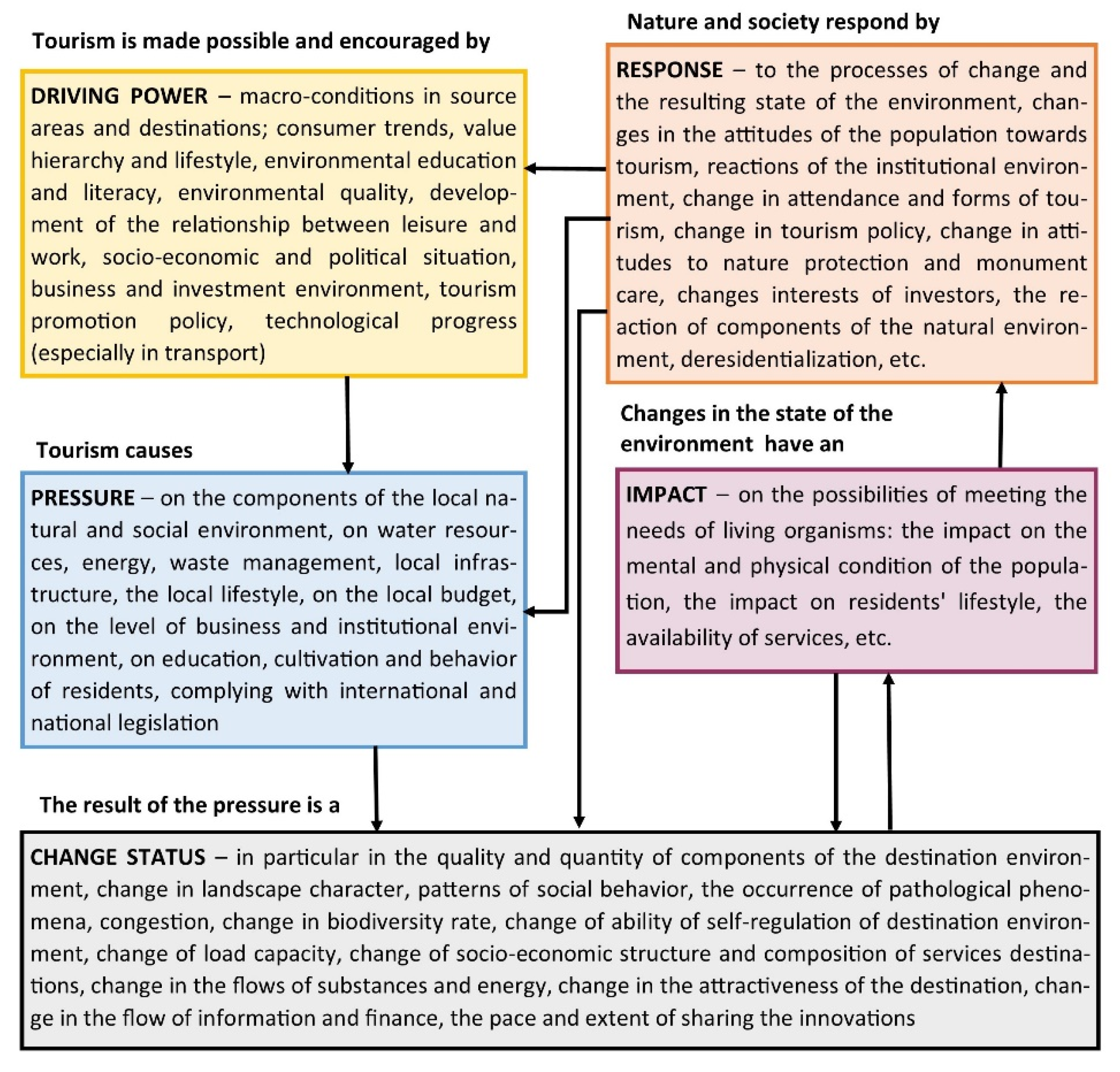
2. Theoretical Background
3. Materials and Methods
4. Results
4.1. Examples of Transformed Territories of Slovakia into Tourism Localities
4.1.1. Alekšince
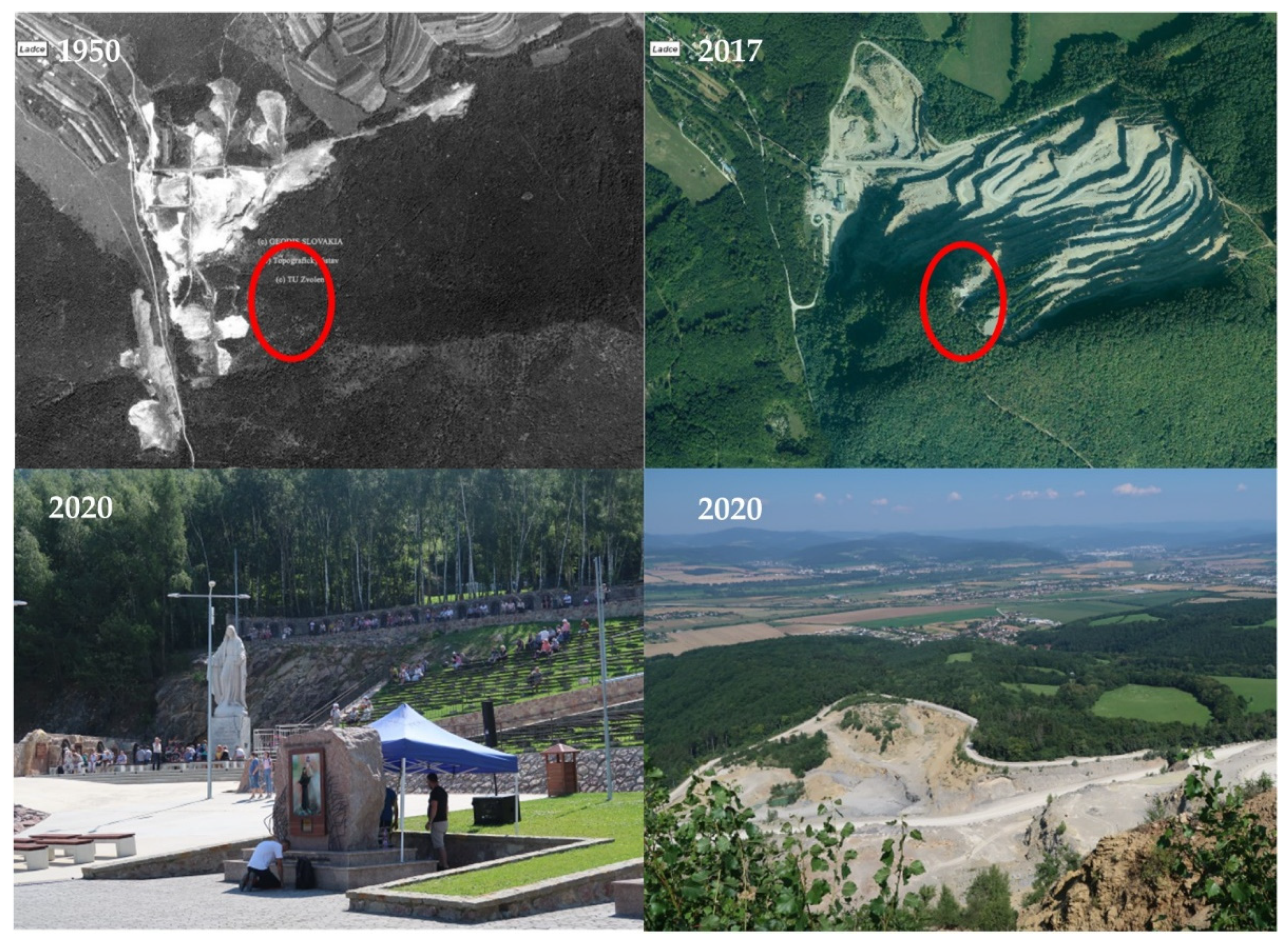
4.1.2. Butkov
4.1.3. Hniezdne
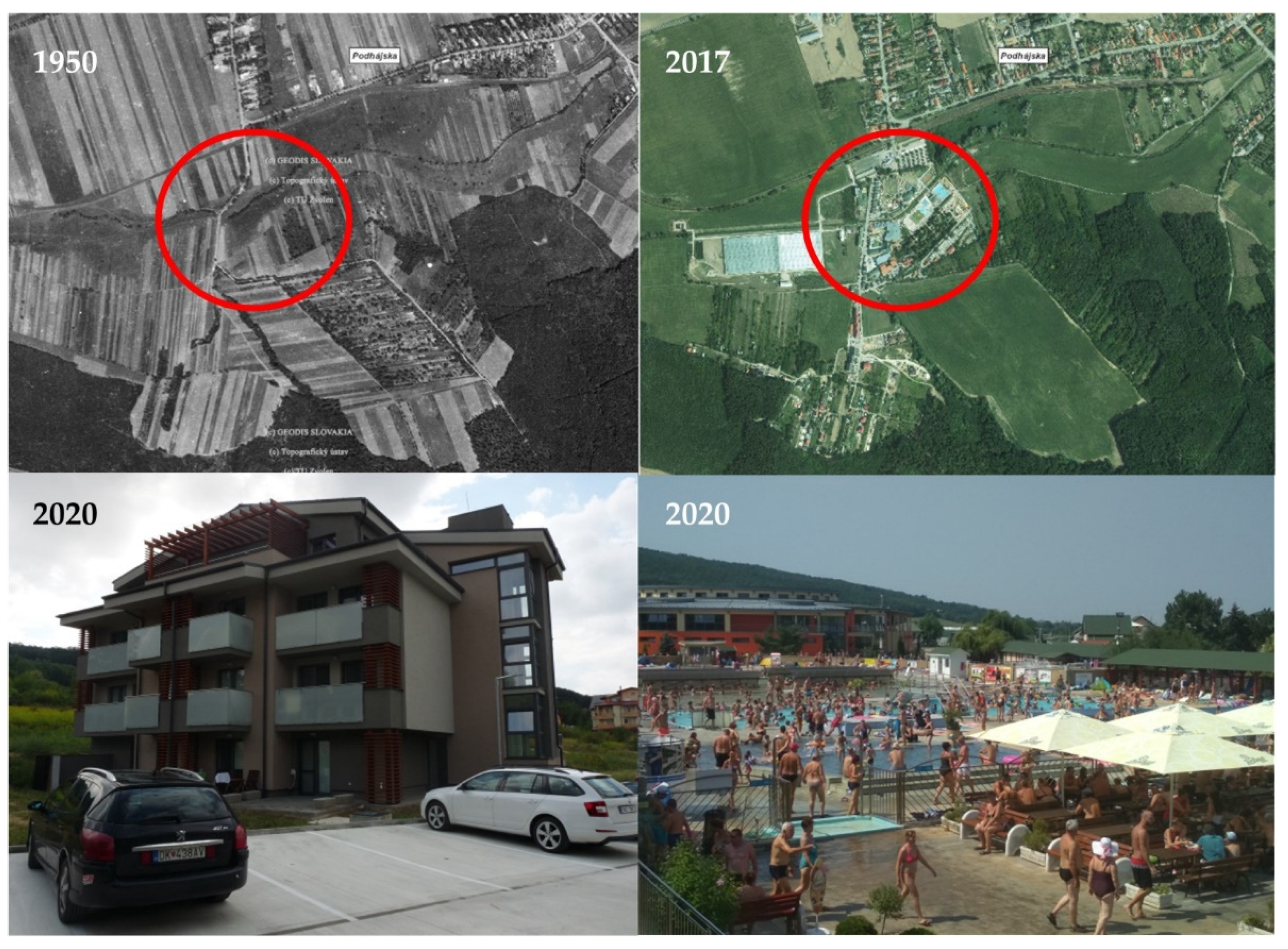
4.1.4. Podhájska
4.1.5. Čierny Balog
4.1.6. Špania Dolina
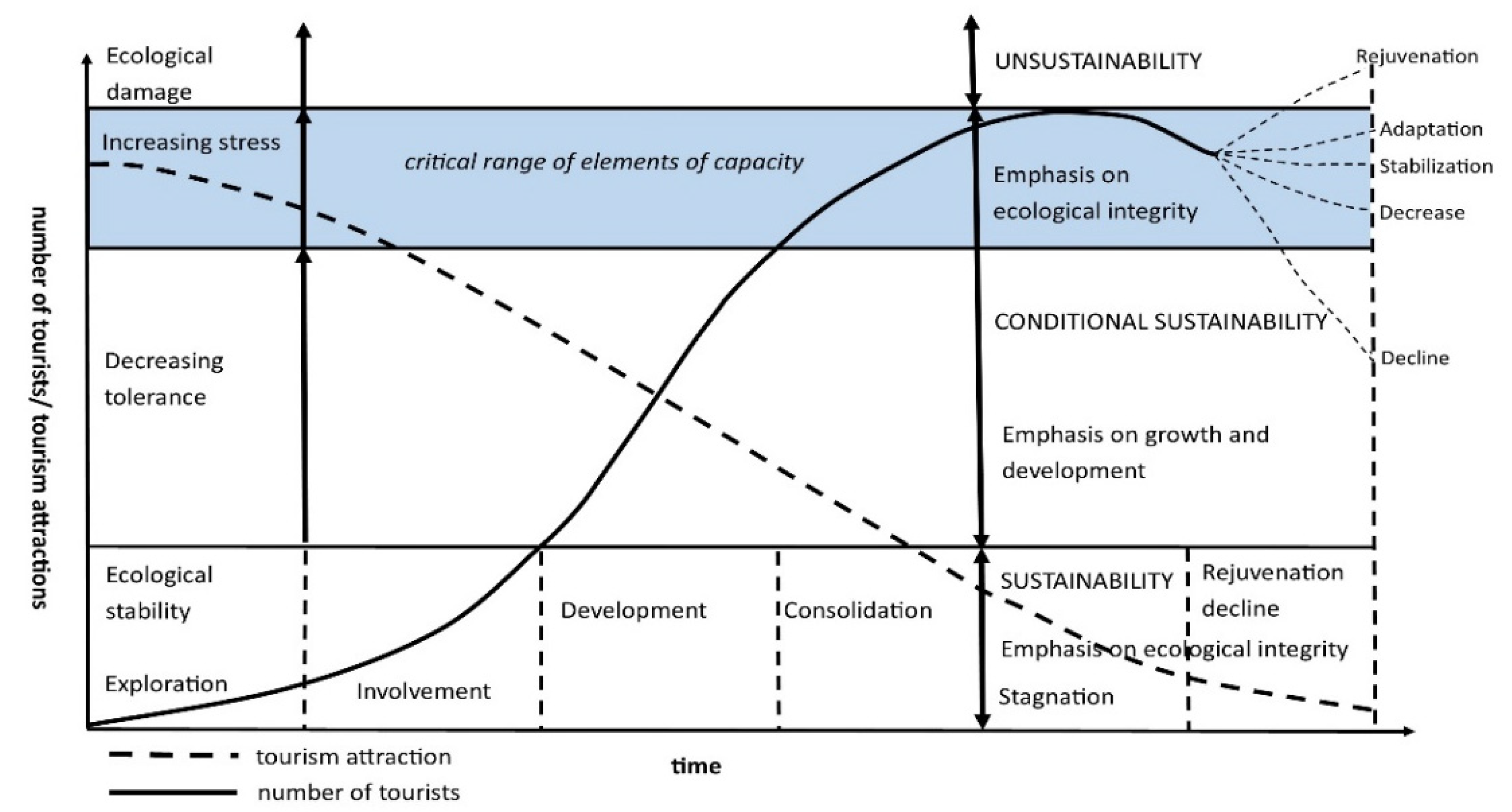
4.2. Life Cycle of Transformed Tourism Sites
5. Discussion
Author Contributions
Funding
Data Availability Statement
Conflicts of Interest
References
- Gregorová, B.; Hronček, P.; Tometzová, D.; Molokáč, M.; Čech, V. Transforming Brownfields as Tourism Destinations and Their Sustainability on the Example of Slovakia. Sustainability 2020, 12, 10569. [Google Scholar] [CrossRef]
- Sołjan, I.; Liro, J. New pilgrimage centre in Kraków’s Łagiewniki-Borek Fałęcki district (In Polish: Nowe centrum pielgrzymkowe w krakowskiej dzielnicy Łagiewniki-Borek Fałęcki). Peregr. Crac. 2014, 25, 135–151. [Google Scholar]
- Sołjan, I.; Liro, J. The changing roman catholic pilgrimage centres in Europe in the context of contemporary sociocultural changes. Soc. Cult. Geogr. 2020, 21. [Google Scholar] [CrossRef]
- Gunn, C.A. Landscape Assessment for Tourism. In Proceedings of Our National Landscape: A Conference on Applied Techniques for Analysis and Management of the Visual Resource, Incline Village, NV, USA, 23–25 April 1979; Pacific Southwest Forest and Range Experiment Station: Berkeley, CA, USA, 1979; pp. 409–414. [Google Scholar]
- Chrenka, B.; Ira, V. Transformation of tourist landscapes in mountain areas: Case studies from Slovakia. Hum. Geogr. 2011, 5, 13–20. [Google Scholar] [CrossRef]
- Hof, A. Urban and tourist land use patterns and water consumption: Evidence from Mallorca, Balearic Islands. Land Use Pol. 2011, 28, 792–804. [Google Scholar] [CrossRef]
- Petrikovičová, L.; Krogmann, A.; Fialová, D.; Svorad, A. Intensive tourist-related urbanisation impacts on a mountain village: The case study of Veľká Lomnica in Slovakia. Geogr. Pol. 2019, 92, 395–408. [Google Scholar] [CrossRef]
- Kadlecová, V.; Fialová, D. Recreational housing, a phenomenon significantly affecting rural ares. Morav. Geogr. Rep. 2010, 18, 38–44. [Google Scholar]
- Hughes, N. ‘Tourists go home’: Anti-tourism industry protest in Barcelona. Soc. Mov. Stud. 2018, 17, 471–477. [Google Scholar] [CrossRef]
- Martín Martín, J.M.; Guaita Martínez, J.M.; Salinas Fernández, J.A. An Analysis of the Factors behind the Citizen’s Attitude of Rejection towards Tourism in a Context of Overtourism and Economic Dependence on This Activity. Sustainability 2018, 10, 2851. [Google Scholar] [CrossRef]
- Žigrai, F. Dimensions and attributes of the cultural landscape (In Slovak: Dimenzie a znaky kultúrnej krajiny). Zivotn. Prostr. 2000, 34, 229–233. [Google Scholar]
- Boltižiar, M.; Chrastina, P.; Kramáreková, H.; Lauko, V.; Šolcová, L. Landscape Research in Case Studies (In Slovak: Výskum Krajiny v Príkladových štúdiách), 1st ed.; FPV UKF: Nitra, Slovakia, 2014; p. 318. [Google Scholar]
- Antrop, M. Landscape change and the urbanization process in Europe. Landsc. Urban Plan. 2004, 67, 9–26. [Google Scholar] [CrossRef]
- Bürgi, M.; Hersperger, A.M.; Schneeberger, N. Driving forces of landscape change current and new directions. Landsc. Ecol. 2004, 19, 857–868. [Google Scholar] [CrossRef]
- Hersperger, A.M.; Gennaio, M.P.; Veburg, P.H.; Burgi, M. Linking Land Change with Driving Forces and Actors: Four Conceptual Models. Ecol. Soc. 2010, 15. [Google Scholar] [CrossRef]
- Lambin, E.F.; Turner, B.L.; Geist, H.J.; Agbola, S.B.; Angelsen, A.; Bruce, J.W.; Coomes, O.T.; Dirzo, R.; Fischer, G.; Folke, C.; et al. The causes of land-use and land-cover change: Moving beyond the myths. Glob. Environ. Chang. 2001, 11, 261–269. [Google Scholar] [CrossRef]
- Oťaheľ, J.; Feranec, J. Research of changes in landscape cover to understand the development of the landscape (In Slovak: Výskum zmien krajinnej pokrývky pre poznanie vývoja krajiny). Geogr. Slovaca. 1995, 10, 187–190. [Google Scholar]
- Oťaheľ, J.; Feranec, J. Research and mapping of land use: The past and the present in the context of Slovakia (In Slovak: Výskum a mapovanie využitia krajiny: Minulosť a súčasnosť v kontexte Slovenska). Geogr. Časopis. 2006, 58, 105–123. [Google Scholar]
- Burley, T.M. Land use or land utilization? Prof. Geogr. 1961, 13, 18–20. [Google Scholar] [CrossRef]
- Prokopová, M.; Cudlín, O.; Včeláková, R.; Lengyel, S.; Salvati, L.; Cudlín, P. Latent Drivers of Landscape Transformation in Eastern Europe: Past, Present and Future. Sustainability 2018, 10, 2918. [Google Scholar] [CrossRef]
- Plieninger, T.; Draux, H.; Fagerholm, N.; Bieling, C.; Bürgi, M.; Kizos, T.; Kuemmerle, T.; Primdahl, J.; Verburg, P.H. The driving forces of landscape change in Europe: A systematic review of the evidence. Land Use Pol. 2016, 57, 204–214. [Google Scholar] [CrossRef]
- Global Land Programme. Available online: https://glp.earth/ (accessed on 13 March 2021).
- Copernicus Land Monitoring Service. Available online: https://land.copernicus.eu/pan-european/corine-land-cover (accessed on 13 March 2021).
- Skowronek, E.; Tucki, A.; Huijbens, E.; Jóźwik, M. What is the tourist landscape? Aspects and features of the concept. Acta Geogr. Slov. 2018, 58, 73–85. [Google Scholar] [CrossRef]
- Terkenli, T.S. Landscapes of Tourism: A Cultural Geographic Perspective. In Tourism and Environment, 2nd ed.; Briassoulis, H., Straaten, J., Eds.; Kluwer Academic Publisher: Dordrecht, The Netherland, 2000; Volume 6, pp. 179–202. [Google Scholar]
- Gkoltsiou, A.; Terkenli, T.S. Tourism and landscape: Toward interdisciplinary analysis of tourist landscape structure. Tourismos 2012, 7, 145–164. [Google Scholar]
- Knudsen, D.C.; Metro-Roland, M.M.; Soper, A.K.; Greer, C.E. (Eds.) Landscape, Tourism, and Meaning, 1st ed.; Ashgate Publishing: Farnham, UK, 2008; p. 157. [Google Scholar]
- Hall, M.; Page, S.J. The Geography of Tourism and Recreation–Environment, Place and Space, 4th ed.; Routledge: London, UK, 2014; p. 448. [Google Scholar]
- Wahab, S.; Pigram, J. Tourism, Development and Growth: The Challenge of Sustainability, 1st ed.; Routledge: London, UK, 1997; p. 302. [Google Scholar]
- Zelenka, J. Selected Approaches to Sustainable Tourism Research. (In Czech: Vybrané přístupy k výzkumu udržitelnosti cestovního ruchu). Czech Hosp. Tour. 2010, 6, 126–136. [Google Scholar]
- Pásková, M. Tourism Environmentalism. (In Czech: Environmentalistika cestovního ruchu). Czech J. Tour. 2012, 1, 77–113. [Google Scholar]
- Szromek, A.R. An Analytical Model of Tourist Destination Development and Characteristics of the Development Stages: Example of the Island of Bornholm. Sustainability 2019, 11, 6989. [Google Scholar] [CrossRef]
- Szromek, A.R.; Kruczek, Z.; Walas, B. The Attitude of Tourist Destination Residents towards the Effects of Overtourism—Kraków Case Study. Sustainability 2020, 12, 228. [Google Scholar] [CrossRef]
- Mariot, P. Geography of Tourism (In Slovak: Geografia Cestovného Ruchu), 1st ed.; VEDA: Bratislava, Slovakia, 1983; pp. 94–210. [Google Scholar]
- Weiss, P.; Jankovičová, M.; Kurčová, E. Regionalization of tourism in the Slovak Republic (In Slovak: Regionalizácia Cestovného Ruchu v Slovenskej Republike), 1st ed.; Ministry of Economy of the Slovak Republic: Bratislava, Slovakia, 2005; pp. 6–88.
- Maps of Slovakia (In Slovak: Mapy Slovenska). Available online: https://www.e-slovensko.cz/s/mapy (accessed on 30 March 2021).
- Historická Ortofotomapa © GEODIS SLOVAKIA, S.R.O. A Historické LMS © Topografický ústav Banská Bystrica. Available online: https://mapy.tuzvo.sk/HOFM/Default3.aspx (accessed on 15 March 2021).
- Ortofotomozaika © GKÚ, NLC, r. 2017. Available online: https://mapy.tuzvo.sk/HOFM/Default3.aspx (accessed on 15 March 2021).
- Gabrielsen, P.; Bosch, P. Environmental Indicators: Typology and Use in Reporting; EEA Internal Working Paper: Copenhagen, Denmark, 2003; p. 20. [Google Scholar]
- Kanianska, R. Integration of Environmental and Economic Policies and the Method of its Evaluation (In Slovak: Integrácia environmentálnej a ekonomickej politiky a metóda jej hodnotenia). Zivotn. Prostr. 2007, 41, 203–205. [Google Scholar]
- Tourism and Its Impact on The environment in the Slovak Republic in 2005 (In Slovak: Cestovný ruch a jeho vplyv na životné prostredie v Slovenskej republike k roku 2005). Available online: https://www.bing.com/newtabredir?url=https%3A%2F%2Fwww.enviroportal.sk%2Fuploads%2Fspravy%2Fturizmus-sektor.pdf (accessed on 29 January 2021).
- Butler, R.W. The concept of a tourism areas cycle of evolution: Implications for the management of recourses. Canad. Geogr. 1980, 24, 5–14. [Google Scholar] [CrossRef]
- Lagiewski, R. The Application of the Talc Model: A Literature Survey. In Aspects of Tourism: The Tourism Area Life Cycle Vol.1 Applications and Modifications, 1st ed.; Butler, R., Ed.; Cromwell Press: Trowbridge, UK, 2006; pp. 27–50. [Google Scholar]
- Kurek, W.; Faracik, E.; Mika, M.; Pawlusiński, R.; Pitrus, E.; Ptaszycka-Jackowska, D. Tourism (In Polish: Turystyka), 1st ed.; Wydawnictwo Naukowe PWN: Warszawa, Poland, 2007; pp. 12–49. [Google Scholar]
- Gregorová, B.; Neradný, M.; Klaučo, M.; Masný, M.; Balková, N. Tourism and Regional Development (In Slovak: Cestovný Ruch a Regionálny Rozvoj), 1st ed.; UMB: Banská Bystrica, Slovakia, 2015; pp. 6–63. [Google Scholar]
- Matlovičová, K.; Matlovič, R. Destination Marketing for Geographers (In Slovak: Destinačný Marketing pre Geografov), 1st ed.; Prešovská univerzita: Prešov, Slovakia, 2017; p. 275. [Google Scholar]
- Unique Attraction near Nitra: Seven Meters Underground, There Is a Museum of Socialism (In Slovak: Unikát pri Nitre: Sedem Metrov pod Zemou sa Nachádza Múzeum Socializmu). Available online: https://dromedar.zoznam.sk/cl/1001069/1949205/Unikat-pri-Nitre--Sedem-metrov-pod-zemou-sa-nachadza-muzeum-socializmu (accessed on 15 January 2021).
- Museum of Socialism and the Cold War (In Slovak: Múzeum Socializmu a Studenej Vojny). Available online: https://miribord.com/sk/aktivity/muzeum/aleksince/muzeum-socializmu-a-studenej-vojny/1623/ (accessed on 30 January 2021).
- Museum of Socialism and the Cold War (In Slovak: Múzeum Socializmu a Studenej Vojny). Available online: http://www.vypadni.sk/sk/muzeum-socializmu-a-studenej-vojny (accessed on 30 January 2020).
- Jančura, B.; Beláček, M.; Slámová, M. Visual Aspects and After-effects of Mineral Resources Mining in Landscape (In Slovak: Vizuálne aspekty ťažby nerastných surovín v krajine). Zivotn. Prostr. 2010, 44, 30–34. [Google Scholar]
- Lintnerová, O. Impact of Mining on the Environment (In Slovak: Vplyv ťažby Nerastných Surovín na Životné Prostredie), 1st ed.; Comenius University: Bratislava, Slovakia, 2002; p. 160. [Google Scholar]
- Siepak, M.A. Rock Sanctuary of God’s Mercy (In Slovak: Skalné sanktuárium Božieho milosrdenstva), 1st ed.; Wydawnictwo Misericordia: Kraków, Poland, 2017; pp. 103–124. [Google Scholar]
- Butkov Cross (In Slovak: Kríž Butkov). Available online: https://www.krizbutkov.sk/ (accessed on 29 January 2021).
- Basal Environmental Information System of Settlements (In Slovak: Bazálne environmentálne informácie o sídlach Slovenska). Available online: http://www.beiss.sk/ (accessed on 15 January 2021).
- Ligus, V. Zoning Plan of the Village of Hniezdne (In Slovak: Územný plán obce Hniezdne), 1st ed.; Ateliér Urbeko, S.R.O.: Prešov, Slovakia, 2008; p. 56. [Google Scholar]
- Nestville Park. Available online: https://www.nestvillepark.sk/nestville-park/ (accessed on 8 February 2021).
- Oremusová, D. Geographical Aspects of Regional Development of the Termál Microregion (In Slovak: Geografické Aspekty Regionálneho Rozvoja Mikroregiónu Termál), 1st ed.; UKF: Nitra, Slovakia, 2009; p. 46. [Google Scholar]
- Žoncová, M. Evaluation of the diversification of rural landscape in Slovakia after 1989 with a focus on the built-up area of municipalities: A case study of Podhájska municipality. Hung. Geogr. Bull. 2018, 67, 143–158. [Google Scholar] [CrossRef]
- The Village of Podhájska. Official Website of the Village (In Slovak: Obec Podhájska. Oficiálna Stránka Obce). Available online: https://www.obecpodhajska.sk/ (accessed on 20 November 2020).
- Supuka, J.; Štefunková, D. Cultural Landscapes and their Historical Values (In Slovak: Kultúrne krajiny a ich historické hodnoty). Zivotn. Prostr. 2014, 48, 3–8. [Google Scholar]
- Forests Slovakia (In Slovak: Lesy Slovenskej Republiky). Available online: https://www.lesy.sk/kontakty/kontaktne-informacie/ (accessed on 20 January 2021).
- Dadová, J. Load of mining country in Špania Dolina area and possibilities of remediation (In Slovak: Záťaž baníckej krajiny v oblasti Špania Dolina a možnosti remediácie). In Proceedings of the 12nd International Conference Management and Environment, Bratislava, Slovakia, 19–20 November 2012; Rusko, M., Ed.; Strix n.f.: Žilina, Slovakia, 2012. [Google Scholar]
- The Village of Špania Dolina (In Slovak: Obec Špania Dolina). Available online: http://www.spaniadolina.sk/en/ (accessed on 20 November 2020).
- Scarabeo-SK, S.R.O. Economic Development and Social Development Program of the Municipality Čierny Balog 2016–2025 (In Slovak: Program Hospodárskeho Rozvoja a Sociálneho Rozvoja obce Čierny Balog 2016–2025), 1st ed.; Scarabeo-SK, S.R.O.: Banská Bystrica, Slovakia, 2015; p. 142. [Google Scholar]
- Supuka, A. Zoning Plan of the Village of Špania Dolina (In Slovak: Územný Plán obce Špania Dolina), 1st ed.; Landurbia: Banská Bystrica, Slovakia, 2019; p. 96. [Google Scholar]
- Čamajová, V. Zoning Plan of the Village of Podhájska (In Slovak: Územný Plán Obce Podhájska), 1st ed.; ABCprint: Žiar nad Hronom, Slovakia, 2017; p. 190. [Google Scholar]
- Wall, G. Cycles and Capacity: Incipient Theory or Conceptual Contradiction? Tour. Man. 1982, 3, 188–192. [Google Scholar] [CrossRef]
- Martin, B.S.; Uysal, M. An examination of the Relationship between Carrying Capacity and the Tourism Lifecycle: Management and Policy Implications. J. Environ. Manag. 1990, 31, 327–333. [Google Scholar] [CrossRef]
- Keller, C.P. Stages of Peripheral Tourism Development—Canada’s North West Territories. Tour. Man. 1987, 8, 20–32. [Google Scholar] [CrossRef]
- Snepenger, D.J.; Reiman, S.; Johnson, J.; Snepenger, M. Is Downtown Mainly for Tourists? J. Travel Res. 1998, 36, 5–12. [Google Scholar] [CrossRef]
- Wall, G. Cycles and capacity: A contradiction in terms. Ann. Tour. Res. 1983, 10, 268–270. [Google Scholar] [CrossRef]
- Stankey, G.H. Integrating wildland recreation research into decision making: Pitfalls and promises. Recreat. Res. Rev. 1981, 9, 31–37. [Google Scholar]
- Getz, D. Capacity to Absorb Tourism: Concepts and Implications for Strategic Planning. Ann. Tour. Res. 1983, 10, 239–262. [Google Scholar] [CrossRef]
- Pásková, M. Udržitelný rozvoj cestovního ruchu. Sborník České Geografické Společnosti. 2001, 20, 178–195. [Google Scholar]
- Russo, A.P. A Stakeholders’ Approach to Tourism Policy in Bruges. In Tourism Studies in Bruges; WES Research and Consultancy: Bruges, Belgium, 2002; pp. 32–41. [Google Scholar]
- Nicu, I.C.; Stoleriu, C.C. Land use changes and dynamics over the last century around churches of Moldavia, Bukovina, Northern Romania—Challenges and future perspectives. Habitat Int. 2019, 88, 101979. [Google Scholar] [CrossRef]
- Schulp, C.J.; Levers, C.; Kuemmerle, T.; Tieskens, K.F.; Verburg, P.H. Mapping and modelling past and future land use change in Europe’s cultural landscapes. Land Use Policy 2019, 80, 332–344. [Google Scholar] [CrossRef]
- Gerard, F.; Petit, S.; Smith, G.; Thomson, A.; Brown, N.; Manchester, S.; Wadsworth, R.; Bugar, G.; Halada, L.; Bezák, P.; et al. Land cover change in Europe between 1950 and 2000 determined employing aerial photography. Prog. Phys. Geogr. 2010, 34, 183–205. [Google Scholar] [CrossRef]
- Ollson, E.G.A.; Austrheim, G.; Grenne, S.N. Landscape change patterns in mountains, land use and environmental diversity, Mid-Norway 1960–1993. Landsc. Ecol. 2000, 15, 155–170. [Google Scholar] [CrossRef]
- Masný, M.; Zaušková, Ľ. Multi-temporal analysis of an agricultural landscape transformation and abandonment (Ľubietová, Central Slovakia). Open Geosci. 2015, 7, 888–896. [Google Scholar] [CrossRef]
- Špulerová, J.; Dobrovodská, M.; Lieskovský, J.; Bača, A.; Halabuk, A.; Kohút, F.; Mojses, M.; Kenderessy, P.; Piscová, V.; Barančok, P.; et al. Inventory and classifcation of historical structures of the agricultural landscape in Slovakia. Ekologia 2011, 30, 157–170. [Google Scholar] [CrossRef]
- Špulerová, J.; Dobrovodská, M.; Izakovičová, Z.; Kenderessy, P.; Petrovič, F.; Štefunková, D. Developing strategy for the protection of traditional agricultural landscapes based on a complex landscape-ecological evaluation (the case study of mountain landscape in Slovakia). Morav. Geogr. Rep. 2013, 21, 15–26. [Google Scholar]
- Štefunková, D.; Špulerová, J.; Dobrovodská, M.; Mojses, M.; Petrovič, F. Traditional agricultural landscapes—A model of detailed land use mapping. J. Landsc. Ecol. 2013, 11, 1–21. [Google Scholar]


| Component | Interpretation |
|---|---|
| D (driving force) | the potential identified by the civic association in the underground military shelter, the effective use of the site, the follow-up to historical events in Slovakia, the development of the village, the revitalization of the area that would otherwise be unused, public interest, overall tourism development |
| P (pressure) | data increase in waste production, increased transport in the village, land use |
| S (state) | data minimal air pollution, a change in the way the site is used, which is not just an environmental burden |
| I (impact) | data operating and modification costs, new jobs, site modification and completion |
| R (response) | contribution to municipal taxes from tourist visits, completion of tourism products, non-traditional forms of tourism, orientation towards cognitive tourism, support of the locality’s educational significance, construction of new attractions using military themes (combat attractions, survival courses, etc.) |
| Component | Interpretation |
|---|---|
| D (driving force) | construction of sacred buildings, public interest in religious and secular motifs, organization of events (pilgrimages, concerts), convenient and transport accessibility, cooperation with the Sanctuary of Divine Mercy in Krakow-Lagievniki, the involvement of the management of Považská cemenáreň, a.s. Ladce and municipality government, trends in tourism that appeal to life attitudes to the search for new, peaceful and spiritual aspects |
| P (pressure) | increasing the production of waste in the complex itself as well as in the parking lot, increasing the built-up area of the complex, or parking areas |
| S (state) | the increased attractiveness of the locality, the village of Ladce and its surroundings, the completion of the elements of the infrastructure of the area |
| I (impact) | costs of infrastructure construction, new jobs, increase in employment, impact on the lifestyle of the residents of the village |
| R (response) | construction of other sacral buildings, construction of accommodation facilities, the cooperation of several regional development subjects, completion of tourism products for domestic and travel agencies from abroad (especially for Polish pilgrims worshipping St. Sister Faustina and St. John Paul II.) |
| Component | Interpretation |
|---|---|
| D (driving force) | cultural and historical heritage (connection to the historical foundations of distillery from the 18th century, monument zone), public interest, quality environment, advantageous transport location, investor interest, new trends in tourism, proximity to large tourist source regions, effective marketing of the area, presentation of the territory in the media |
| P (pressure) | increase in waste production, increased water consumption, impact on water quality, increase in built-up area (by 5.9% since 2011), increased traffic in the municipality, impact on local culture |
| S (state) | minimal air pollution, no significant source of pollution, land use was added, other non-agricultural land area decreased by 2%, land acculturation, preference of current trends, revitalization of agricultural brownfield |
| I (impact) | increasing the cost of building infrastructure, supporting local agriculture, new jobs, increasing the employment of the local population, impact on protected areas, new types of experiences for visitors, loss of community identity |
| R (response) | contribution to the taxes of the municipality, completion of tourism products, support of agritourists, restoration of spas based on the tradition of the 19th century |
| Component | Interpretation |
|---|---|
| D (driving force) | potential of thermal water, healing effects of thermal water, sufficient capacity of water sources, increasing interest of visitors in services, development of the village, overall development of tourism, effective marketing |
| P (pressure) | increase in waste production, increased consumption of water and thermal water, increased frequency of transport, change of land use, loss of authenticity of the village, need to build tourism infrastructure, increase in land and real estate prices, increase in attendance |
| S (state) | minimal air pollution, change of use of real estate, deterioration of surface and groundwater quality, duality of local community in perception of tourism, marginalization of local population, rising land prices, excessive tourism, outflow of young population from the village, irritation by the tourists |
| I (impact) | costs of building infrastructure, new jobs, increasing employment in the municipality, new services |
| R (response) | contribution to the taxes of the municipality of tourism, building of the infrastructure of the municipality, completion of tourism products, orientation to the spa tourism |
| Component | Interpretation |
|---|---|
| D (driving force) | presentation of the history, cultivation and importance of the forest, a demonstration of traditional forest management from the Horehronie region, timber transport by old fashioned railway, the interest of visitors, the authenticity of the environment, the preservation of the traditional culture of the region |
| P (pressure) | increased waste production, increased water consumption, increased traffic in the village, problems with parking |
| S (state) | no significant air pollution is recorded, no significant source of pollution has been added, increased noise in the main season |
| I (impact) | infrastructure construction costs (catering facilities, parking spaces), new jobs, craft support |
| R (response) | contribution to the municipality’s taxes, traditional logging and attractive historical railway is a sustainable product of tourism |
| Component | Interpretation |
|---|---|
| D (driving force) | Medieval mining and its historical heritage, to preserve and maintain the characteristic manifestation of mining activities (recreational, cultural, social and educational function), the attractiveness of the area, society’s demand for tranquility in less frequented tourist areas, high-quality air, advantageous geographical location, monuments’ authenticity |
| P (pressure) | increased traffic density, worn state of the communications, the requirement to build accommodation facilities, endangering the stability of selected forms of relief, increased interest in real estate, preferring the needs of visitors to residents |
| S (state) | undesired change of landscape character, landslides |
| I (impact) | infrastructure construction costs, impact on the biodiversity of the area, rising real estate prices, marginalization of the needs of residents |
| R (response) | transformation of history into products of tourism, cognitive tourism, objects respecting the monument values of the area, construction of car parks outside the monument reservation, lace-creating workshops |
Publisher’s Note: MDPI stays neutral with regard to jurisdictional claims in published maps and institutional affiliations. |
© 2021 by the authors. Licensee MDPI, Basel, Switzerland. This article is an open access article distributed under the terms and conditions of the Creative Commons Attribution (CC BY) license (https://creativecommons.org/licenses/by/4.0/).
Share and Cite
Oremusová, D.; Nemčíková, M.; Krogmann, A. Transformation of the Landscape in the Conditions of the Slovak Republic for Tourism. Land 2021, 10, 464. https://doi.org/10.3390/land10050464
Oremusová D, Nemčíková M, Krogmann A. Transformation of the Landscape in the Conditions of the Slovak Republic for Tourism. Land. 2021; 10(5):464. https://doi.org/10.3390/land10050464
Chicago/Turabian StyleOremusová, Daša, Magdaléna Nemčíková, and Alfred Krogmann. 2021. "Transformation of the Landscape in the Conditions of the Slovak Republic for Tourism" Land 10, no. 5: 464. https://doi.org/10.3390/land10050464
APA StyleOremusová, D., Nemčíková, M., & Krogmann, A. (2021). Transformation of the Landscape in the Conditions of the Slovak Republic for Tourism. Land, 10(5), 464. https://doi.org/10.3390/land10050464