Abstract
The land topic has generally become a major socioeconomic issue that currently attracts attention globally. To explore the issue, various countries devote much attention to land use planning. This paper searches the Core Collection of the Web of Science and collects 1771 land use planning articles published between 1990 and 2019. The R software, biblioshiny package, and CiteSpace are applied in this paper. The results show the following: (1) the number of papers related to land use planning has shown an overall growth trend, which can be divided into the following four stages: initial exploration, preliminary growth, stable development, and rapid development; (2) the United States is in an absolute leading position as the primary research force among developed countries. The top 3 countries related to international cooperation are the United States, China, and Italy; (3) land use planning, land use, GIS, urban planning, China, spatial planning and climate change are some high-frequency keywords used in land use planning; (4) the current research hot spots mainly focus on the relationship between land use spatial planning and regional planning, land informatization development, public participation, urban sprawl, and sustainable development; (5) the themes show 8 evolutionary paths related to the following four topics: ecosystem protection, climate and natural change, urban sprawl and agricultural development, and GIS development; (6) this paper proposes that strengthening integration within disciplines, introducing new theories and methods, and sustainable land use will become future research directions requiring more land use planning attention.
1. Introduction
Land resources are the foundation for human living and survival, are nonrenewable resources, and provide critical materials and space for human development [1]. Since the 20th century, the world’s land-use patterns have rapidly changed due to the rapid increase in the population, urbanization, and industrialization [2,3,4,5]. Therefore, various land use planning projects have been implemented in different countries. To reasonably plan land use and allocate the limited land resources effectively, while meeting the requirements of human production and life, have become a critical issue. Thus, grasping the historical development of land use planning, identifying its development status, and exploring its future development have become current research hot spots.
Land use planning refers to the reasonable preparation, arrangement and allocation of future land use to enable more significant comprehensive benefits in a specific area [6]. Various countries use other terms to refer to this concept, including land planning, regional planning [7], territory planning [8], land use planning and urban planning [9,10]. From a historical perspective, urban land use planning systems in developed countries are generally divided into two stages. The first stage is only characterized by rapid population concentrations in large cities, which is called “one-way urbanization” land use policy; the second stage comprises the subsequent stages of industrialization and urbanization which the advanced factors of production are concentrated in cities and infiltration and diffusion to rural areas occur, corresponding to a multidirectional diffusion land use policy [11].
Due to differences in social institutions, land property rights systems, land management systems and basic national conditions of land among various countries and regions worldwide, the nature of land use planning varies in each country [11]. Germany was the first country to implement such plans during the beginning of the 20th century [12]; subsequently, countries, such as the United Kingdom [13], Japan [14] and the United States [15,16], have successively carried out land planning projects. Those cases show that the core content of land use planning mainly refers to adjusting and optimizing the structures of land resources in a scientific way [17]. Currently, land planning methods are developing in the directions of informatization, diversification and integration. To improve the efficiency and scientific nature of land use planning, the methods used in this field have evolved from traditional methods, such as qualitative descriptions and comparative analyses, to modern methods, such as gray control systems [18], analytic hierarchy processes (AHPs) [19], system dynamic models [20] and multiobjective decision planning [21]. Additionally, at the technical level, land use planning has become smart with the extensive use of remote sensing (RS) and geographic information system (GIS) technology. Moreover, some countries (e.g., the USA, Japan, the UK) apply decision support systems (DSSs) to land use planning, representing an obvious turning point in technical innovation in this field [22]. At the nature level, land use planning is a comprehensive research project that considers not only the natural impacts of land but also the economy and human activity attributes; additionally, last but not least, land use planning must consider the ecological, economic and social benefits that it provides.
This field’s current research state can be grasped by examining recent papers concerning land use planning. To date, several papers reviewing existing land use planning research have been published [22,23,24]. For example, Riveira and Maseda (2006) analyzed and compared the different models required for land use planning to provide proper references for its application to rural contexts [22]. Geneletti et al. (2017) explored the methods and challenges related to applying sustainable planning to areas surrounding a city by reviewing 102 papers related to the sustainable planning of urban peripheries [23]. Ayambire et al. (2019) discussed how to maintain urban agriculture in a city and its surrounding areas in an era of scarce land [24]. Literature review is usually based on summarizing and generalizing the outcomes of the research examined although it can provide information regarding the results of research published during a certain period [25,26,27]. However, such articles mentioned above tend to select papers in a relatively subjective way, and some papers consider only one region or a country; therefore, these studies lack an international comparative perspective [28].
Bibliometrics is a smart method used to evaluate the results of scientific research. The external characteristics of a body of scientific literature are considered the research object, and the distribution structure, quantitative relationships and change law of the literature are studied [29,30]. Moreover, bibliometrics has obvious advantages in terms of objectivity, quantification and modeling from a macro perspective [25]. In general, bibliometrics is a mature and smart method used in document analyses and information mining [31]. Using bibliometric methods, scholars have conducted several studies in the field of land use planning and obtained certain research results [32]. For example, Gobster used VOSviewer software (produced by Van Eck and Waltman of the Centre for Science and Technology Studies of Leiden University in the Netherlands, version 1.6.14) to qualitatively compare the co-occurrence term maps generated by the abstract text corpus accumulated throughout the four decades of the journal Landscape and Urban Planning, which focuses on urban planning and landscape science [31]. However, this study’s research content mainly comprised statistical analyses of publications in the literature, high-frequency keyword cluster analyses, co-occurrence analyses and analyses of authors and research institutions. Notably, research concerning the evolutionary trend, core literature citation history and hot topics is still lacking.
In this article, the bibliometric analysis methods of information science and a new set of R packages were applied to study relevant land use planning research in the Core Collection database of the Web of Science published between 1990 and 2019. This paper conducts a quantitative analysis to depict the overall development trend of land use planning in a detailed and comprehensive way, clarify the framework of land use planning research, and examine the evolutionary trends. Exploring the research status of land use planning and studying the future development direction in this field are not only helpful but also have a certain significance for research concerning information science. This article analyzes the research trend of land use planning from multiple perspectives and provides references and suggestions for future research while promoting the interdisciplinary integration of land use planning. Therefore, the main research questions of this paper are as follows:
- (1)
- What was the development trend of land use planning during the 1990–2019 period?
- (2)
- What is the current research status of land use planning?
- (3)
- How have the main themes of land use planning evolved?
- (4)
- What are the focus and direction of future research in the field of land use planning?
2. Data sources and Methodology
2.1. Data Sources
We used the Core Collection of the Web of Science and selected the SCI-E, SSCI and ESCI as its data source. Notably, the ESCI, which accelerates the exchange of scientific circles, has a positive impact on scientific research evaluation [32]. Thus, this study used “Article” as the document type and “Title” search as the retrieval method; additionally, all languages are included, and the following search formula is utilized: TI = (land use planning OR TI = land planning OR TI = landscape planning OR TI = land spatial planning). After data deduplication, 1771 papers concerning land use planning published between 1990 and 2019 are finally obtained.
2.2. Methodology
2.2.1. Bibliometric Tools Based on R Language
Bibliometrics is a quantitative statistical method used to analyze the distribution of scientific papers by using mathematical statistics technology. The R-based bibliometric software package, which can process information from the Scopus and Web of Science databases, construct a co-occurrence matrix, perform co-citation, coupling, collaborative, coword, and topic evolution analyses [33,34]. The VOSviewer package of R language was applied to explore the collaboration network of 20 high-producing countries in the field of land use planning. However, only a few scholars use bibliometrics for scientific literature mapping. Considering the strengths of the analysis tools mentioned above, this paper attempts to apply this approach to the research field of land use planning and conducts a bibliometric analysis in this field (Figure 1).
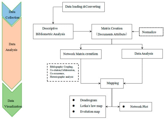
Figure 1.
Bibliometrics analysis workflow of this study.
2.2.2. CiteSpace
CiteSpace is a software used to identify and display new trends in the scientific literature and new advances in scientific development. In this article, CiteSpace 5.6.R5 is applied to conduct a keyword burst analysis.
2.2.3. Multiple Correspondence Analysis
Multiple correspondence analysis is a commonly used method in the context of sociology [35]. This method compresses a large amount of data into low dimensions to form two-dimensional (or three-dimensional) graphics to reflect the similarity between them. The keywords that are closer to the center of the graph and distributed in a more concentrated manner are the keywords that have received more attention during recent years, while those that are more evenly spread are related to less frequently discussed research topics or transitions to other topics.
3. Results and Discussion
3.1. Literature Timing Analysis
Although the number of papers published concerning the land use planning topic has decreased during the past few years, the number of articles published each year has generally increased (Figure 2). The overall trend can likely be divided into the following four different stages. (1) Initial exploration (1990–1997): Land use planning research was in its infancy during this stage. There are 70 related papers during this period; additionally, the average annual volume is 10 papers, and few papers were published each year. However, the field exhibited a basic growth trend during this period. (2) preliminary growth stage (1998–2006): In total, approximately 337 papers were published during this stage and the annual volume of publications is 37; the number of articles published shows an overall growth trend with fluctuations, and this topic attracted widespread attention from scholars worldwide, resulting in a period of expansion and promotion. (3) Stable development stage (2007–2013): The average annual number of papers published during this stage is 53, and in contrast to the previous stage, this period exhibits a steady increasing trend. (4) Rapid development stage (2014–2019): The number of papers rapidly increased during this stage. On average, 103 related papers were published annually, and the field reached its highest peak in 2018 with the publication of 136 papers.
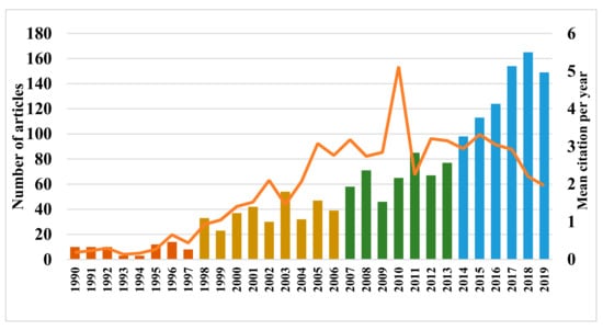
Figure 2.
Number of papers and mean citation per year in the field of land use planning.
As shown in the annual distribution chart of the average citation frequency, this field reached high peaks in 2002, 2005 and 2010; additionally, an overall declining trend can be observed after 2015. This finding suggests that the annual number of citations of papers in this field does not maintain an overall growth trend similar to the number of papers produced; instead, this number greatly fluctuates. Therefore, from this perspective, the citation frequency of the papers in this discipline has decreased yearly since 2015. In addition, the quality and influence of these papers have declined. This finding indicates that the field of land use planning has recently entered a low period. Notably, this research period showed the largest output of highly cited papers, indicating that the topic of land use planning attracted the attention of scholars worldwide during this period.
3.2. Citation Context Analysis of Land Use Planning Research
The original data were analyzed according to the local citation score (LCS) and global citation score (GCS) (Table 1). The LCS refers to the number of citations of a given paper in a local dataset. The GCS refers to the total number of citations of papers in the science network database, but the cited papers are not necessarily papers in the research field.

Table 1.
Top 10 local citation score (LCS) in the land use planning field.
As shown in Figure 3, the literature nodes from 1990 to 1998 are blank, indicating that there were no highly cited papers published during this period. The first wave of intensive citations occurred between 1999 and 2010. During this period, a group of classic papers appeared. The paper with the highest LCS and GCS is A genetic algorithm approach to multiobjective land use planning, which was published in Computers & Operations Research [36]; the LCS and GCS of this paper are 17 and 180, respectively. This article developed a unique genetic algorithm and conducted extensive numerical tests to solve the nonlinear combination optimization problem encountered in the allocation of land to different uses in the context of spatial planning. The article Land-use planning in the vicinity of major accident hazard installations in Greece, which was published in the Journal of Hazardous Materials, presents 6 clear citation relationship chains [37]. This finding shows that such research has continuity, consistency and stability in the field of land use planning. Notably, the two journals mentioned above are non-planning journals, revealing that land use planning is a multidisciplinary scientific field that includes both social science and nature science.
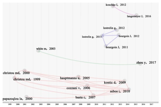
Figure 3.
Citation network of the most-cited papers in land use planning studies (1990–2019).
The second wave of intensive citations occurred between 2010 and 2013, and the citation relationships during this period tended to be stronger. This finding shows that the research field of land use planning was very active during this period, and the two papers published in 2011 were cited frequently [38]. The paper Measuring participation: Case studies on village land use planning in northern Lao PDR, which was published in Applied Geography in 2011, also cited 2 important papers from 2011 and was a part of multiple citation relationship chains, rendering it a critical node during this research period [39]. This study analyzed the extent to which the evolution of rural land use planning in Laos led to the increased local participation and improved livelihoods. The results show that local participation in the study area exhibited only limited growth after the implementation of land use planning. However, the impact of this implementation on the evolution of local land use methods and the realization of the sustainable use of regional land resources were very limited. During the 2014–2019 period, there was no particularly dense group of citations.
3.3. Analysis of the Main Authors
In this research, Lotka’s law map was applied to analyze the main authors of the examined research (see Figure 4). This figure shows that 3504 scholars published a single paper and that these papers account for 90.2% of all papers. In addition, 381 scholars published more than two papers, accounting for 9.8% of the total number of paper (Table 2). It can be observed that the publishing frequency of the authors in the field of land use planning corresponds to the dotted line in Figure 4, which basically conforms to the general law of Lotka’s law. This can indicate that the number of authors who have written only one or two papers in the field of land ecosystem services is relatively large. Moreover, this finding reflects that most scholars in this field have only entered the field and that research concerning land use planning may not be deep enough.
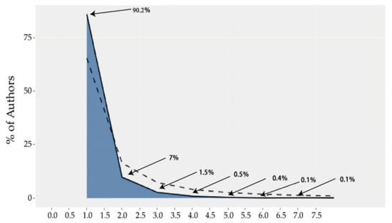
Figure 4.
Frequency distribution of scientific productivity in land use planning.
Table 2.
Distribution of authors and their publications.
3.4. Main Research Country/Region Distribution Characteristics.
To a certain extent, the publication of papers in various countries can generally reflect the influence and importance of land use planning. In general, the more country publishes in a certain scientific field, the higher its related publication volume and citation index, which proves the influence and quality of its articles. The top 5 countries in terms of publication volume are the United States, China, the United Kingdom, Australia and Canada. As shown in Figure 5, these publications are mainly concentrated in developed regions, for example, Europe and North America, showing that most of these regions are at the forefront of land use planning research.
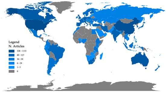
Figure 5.
Countries’ scientific production in the field of land use planning.
China belongs to the top five, is the only developing country among these five countries and accounts for 11.7% of the publication volume of 93 countries; additionally, China’s output is relatively high. However, the average citation frequency of its papers is only 14.85, indicating that although many articles concerning land use planning are published in China, the quality of these papers still needs to be improved.
The information regarding the top 20 countries in terms of the publication volume is shown in Table 3. The scientific research strength in developing countries is lower than that in developed countries. Among the top 20 countries listed, only China, India, Iran, Portugal and South Africa are developing countries, and their publications account for only 17.1% of the total. The number of included countries in Europe and America is obviously higher than that in Africa, Asia, and Oceania. From the perspective of international cooperative relations in terms of publishing, the United States and China have performed well as they have 52 and 38 international cooperative papers, respectively. Most countries listed focus on independent research, and there are more domestic collaborative papers than international collaborative papers (Figure 6). In the future, the cooperative relationships between countries should be strengthened and the number of cooperative papers should be increased.
Table 3.
Status of the main countries engaged in land use planning from 1990 to 2019.
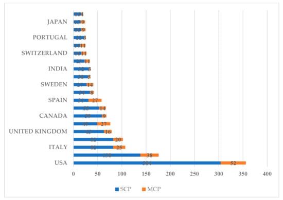
Figure 6.
Top 20 producing countries and the corresponding authors in land use planning studies.
The command vos.path = ““, type = “Vosviewer”, size = T, delete. multiple = T has been used to call the VOSviewer software application and produce cooperative maps of the 20 countries. In a collaboration map, the thicker a given connection line is between two countries, the stronger the cooperative relationship between the countries, and vice versa (Figure 7). As shown in Figure 7, the number of international cooperative papers published in the United States and China are 52 and 38, respectively. The United States ranks first in terms of the publication volume in the field of land use planning, but these publications mainly focus on independent research. Notably, the most strong cooperative link is between the United States and China. As shown in Figure 6, most of these countries focus on independent research, and they publish more domestic cooperative papers than international cooperative papers.
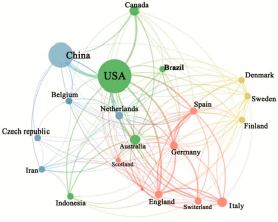
Figure 7.
Collaboration map of the most-producing countries in the field of land use planning.
3.5. Keywords Analysis
3.5.1. High-Frequency Keyword Analysis
Using the package biblioshiny, we can mine and count the high-frequency keywords used by the authors of the examined research papers, filter the keywords with word frequencies greater than or equal to 10, and draw a word tree map (Figure 8). The most commonly used keywords in the research topic are land use planning, land use, geographical information systems (GISs), urban planning, China, spatial planning and climate change, accounting for 11.9%, 9.6% 5.3%, 3.7%, 2.9%, 2.5%, and 2.4% of the high-frequency keywords, respectively. This finding shows that land use planning research has relatively extensively focused on GIS, urban (spatial) planning, and climate change. This finding also reveals that urban planning for geographic environment assessments usually requires a large amount of spatial information. In addition, geographical information systems (GISs) can analyze a large amount of spatial data and provide a reference for formulating land use planning policies [39,40]. We can apparently observe that China appears in the top ten high-frequency keywords. This finding also indicates that the quantity of papers by Chinese authors exponentially increased in recent years, which is consistent with the finding previously discussed in Figure 5.
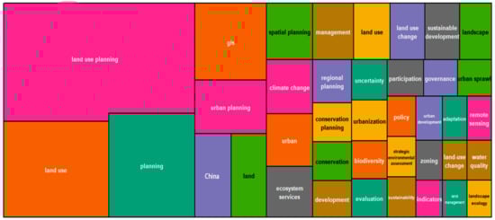
Figure 8.
Word TreeMap of high-frequency keywords in the field of land use planning.
3.5.2. Burst Keyword Analysis
Burst keywords can help identify cutting-edge topics. As shown in Figure 9, there were 11 burst keywords used in land use planning between 1990 and 2019. Among these keywords, the earliest burst keyword, namely, landscape ecology, emerged in 1999 [41]. This finding also shows that land use planning based on landscape ecology, especially under the background of ecosystem management, is the frontier research field of land use planning in the early 21st century and is initially explored and developed during the study period [42]. The core of this concept is the combination of landscape ecology and land use planning. To link ecological, social and economic issues on a larger spatial and temporal scale, landscape ecology is integrated into urban and rural planning, construction processes, the overall arrangement and scientific planning of regional economies, and urban and rural construction.
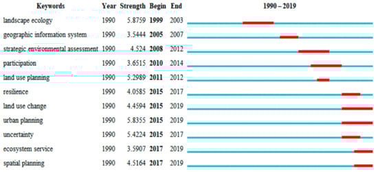
Figure 9.
Top 11 keywords with the strongest citation bursts.
The burst keywords land use change, urban planning, ecosystem services and spatial planning appeared during the later period discussed and continue to the present. This phenomenon indicates that urban planning and spatial planning are the main subjects of recent research. Notably, in 2019, the application between ecosystem services and land use planning has become the forefront in this field, further showing that the impact of land use planning on the ecological environment system is a key topic to be considered currently and in the future.
3.5.3. Cluster Analysis and Multivariate Statistical Analysis of the High-Frequency Keywords
This article uses the hierarchical clustering method to analyze the keywords of land use planning. First, the keywords of each cluster are regarded as a category, and then, each cluster is merged with the cluster most similar to it to form a new larger cluster. Then, each new cluster is merged with the most similar cluster. The above steps are repeated until all individual clusters are grouped together. Finally, the whole classification system is formed into a tree diagram to show the relationship between the keywords in the field of land use planning (Figure 10).
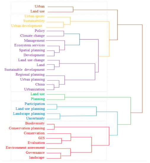
Figure 10.
Tree dendrogram of the hierarchical clustering of keywords in land use planning.
By combining the information shown in Figure 10 and Figure 11, it can be systematically observed that the research field of land use planning can be summarized into the following four categories.
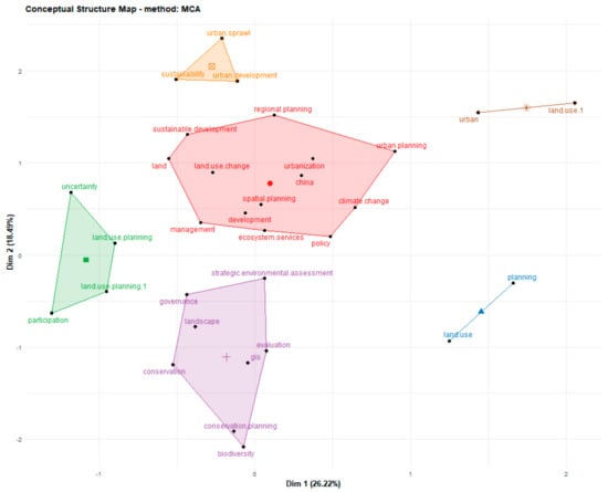
Figure 11.
Multiple correspondence analysis of high-frequency keywords in land use planning.
The first category mainly includes the relationship between land use changes and spatial/regional planning. With the rapid development of the social economy, cities’ land use/land cover (LULC) has undergone extensive changes, which most related to the increase in developed areas (e.g., cities, industry, commerce and transportation) and the abandonment of agricultural land) [43].
The second category mainly reflects the relationship between GIS technology and environmental landscape protection and ecosystems. Under the pressure of rapid urbanization, land use conversion has had many negative impacts on local ecosystems and environments, for example, a decline in ecosystem service values [44,45,46].
The third category mainly focuses on the interaction between various participants and land use planning. An increasing number of stakeholders are becoming involved in environmental policies and land policies. Land use planning is an activity that affects the entire society. Land use planning involves different individuals, collectives, and organizations. Therefore, it is necessary for the public to participate in such planning [47,48].
The fourth category revealed by the cluster analysis mainly focuses on urban expansion and sustainable development. This finding suggests that high-level spatial resolution data are urgently needed to support sustainable urban planning and decision-making when establishing the relationship between social and economic performance of urban systems and different subunits (e.g., housing plans, commercial and industrial development, and services) [49,50,51].
3.6. Thematic Evolution Analysis of Land Use Planning
The evolution analysis of a given subject shows the change rules, evolutionary relationships, paths and trends of the content. This analysis also shows the intensity and structure of the subject over time. A topic evolution analysis plays a special role in identifying the development context of a field, understanding its direction and expecting its future trends [52]. The thematic evolution of land use planning studies is shown in Figure 12.
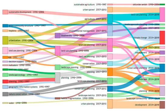
Figure 12.
Thematic evolution of land use planning studies from 1990 to 2019.
3.6.1. Impact of Land Use Planning on Ecosystem Protection
- ①
- landscape ecology→planning→conservation→landscape.
From 1990 to 1997, land use planning was closely integrated with landscape ecology. Notably, ecosystem services began to be integrated with land use planning when a study concerning the value of ecosystem services was published in Nature [53]. Smart land use planning should seek a balance between the infrastructure needed for the growing needs of the human population and environmental protection [54,55].
- ②
- landscape planning→land-use planning→management, landscape, planning.
Globally, the continuous population increase and rapid development of the economy have caused continuous harm to the ecosystem, leading to the degradation of ecosystem services in many regions. Therefore, current land use planning research and practice increasingly focus on the importance of ecosystem services. From 1998 to 2013, this theme gradually evolved in many ways (e.g., conservation and biodiversity). Because habitat loss due to urbanization is a primary threat to biodiversity and land-use decisions, land use planning plays a substantial potential, but largely unrealized, role in conserving biodiversity [56].
- ③
- nature conservation→landscape planning, conservation planning, environment management→landscape→climate change.
During this period, combining land use planning with biodiversity conservation was always the focus of biodiversity conservation groups proposed comprehensive methods to address this issue [57]. An important suggestion that these methods make is that local governments should conduct natural resource mapping and establish conservation priorities [58]. Reyers et al. (2012) used multiregional conservation planning methods to explore the costs and benefits of the conservation of biodiversity in Little Karoo, South Africa and issues related to various land use configurations [58]. From 2014 to 2019, the concepts of land use planning and ecosystem services became closely integrated. In particular, ecosystem services are highly connected to conservation planning [59]. For example, Wang et al. (2006) applied ecosystem service value accounting to planning evaluations to estimate the changes in the value of ecosystem services caused by land use planning [59]. In addition, the spatial pattern of ecosystem services has been applied to regional nature reserve planning and ecological security pattern construction [60,61]. Combining the economic and ecological benefits introduced by land use changes has substantial meaning in terms of land use planning. In addition, this combination provides a method for conducting ecological quantitative research concerning land use planning.
3.6.2. Land Use Planning and Research Investigating the Impact of Climate Change and Natural Environment Changes
- ①
- land planning→environment management→climate change.
As is well known, land use planning has a profound impact on climate change [62]. Therefore, to some extent, land use planning plays a key role in addressing the impact of climate change. For this reason, local efforts exerted to cope with climate change may change the local land use pattern. Some studies have begun to explore the role of local land use policies under climate change from 2007 to 2013 [63,64,65]. Notably, relatively few studies examined how to use the concept of climate change to form local land use planning tools and how to integrate climate change adaptation strategies and mitigation measures into local land use planning [66]. Tang et al. (2009) indicate that limited awareness and consideration of climate change are reflected in local land use policy [42]. Meanwhile, due to frequent climate extreme events, human society began to rethink the relationship between climate and terrestrial ecosystem from 2014 to 2019. In the western USA, climate changes have generally caused diverse impacts, including forest fires, droughts, and floods, which are projected to increase in severity and frequency in the future [40]. These climate change impacts threaten public land management agencies, which manage an average of 48.3% of the land in 12 western states. It is also possible that resources and livelihoods in some regions can be influenced by climate-driven changes; for instance, such changes could trigger increased tourism in high-elevation, cool places during heat waves at lower elevations [67].
3.6.3. Relationships among Land Use Planning, Urban Expansion and Agricultural Development
- ①
- urbanization→planning→agriculture→land use planning.
During the urbanization process, land is the basis of socioeconomic development and the main resource of agricultural production. State administrative agencies are facing the contradiction of not only protecting agricultural land but also protecting land for economic and social development [68,69]. Land use planning has played a critical role in controlling the rapid expansion of urban construction land. Urban growth boundaries are established by these plans; thus, cities can focus on compact layouts and intensive development to improve the efficiency of the utilization of land resources [70]. In addition, these plans consider both rigidity and flexibility when controlling the total supply of land, which is significant for protecting farmland. In this context, the promotion of urban development has played a guiding role as it also protects arable land. Finally, smart land use planning can rationally allocate industrial and residential land and improve land use efficiency through the allocation of land to different uses, thereby improving people’s quality of life [71].
- ②
- urban sprawl→land use planning→agriculture.
From 1998 to 2006, the main themes of land use planning focused on coordinating and controlling urban expansion. Land use planning focused on avaricious uses of land, uninterrupted urban spatial expansion, scattered and discontinuous development and inefficient uses of land. Urban sprawl has posed many challenges in countries worldwide and has become a subject of global interest [72,73]. The high-tech Hsinchu region in northern Taiwan was used as a case study to investigate how the oversupply of serviced land and urban sprawl generated an inefficient spatial pattern of urbanization in the region that had wide-ranging impacts on urban and regional development [74]. The findings suggest that urban sprawl in the region is caused by the high-tech sector’s economic growth, but the decisions made by land use management aggravated the political motivation. From 2007 to 2013, the research direction of land use planning gradually began to evolve towards agriculture. This finding indicates that the typical ecological consequence of agriculture is the depletion and degradation of cultivated land. Scholars have reported that urban sprawl has overtaken prime farmland in many places worldwide. The fierce conflict between the rapid urban sprawl and the decrease in cultivated land area and quality has introduced great challenges to sustainable development because this problem is closely related to food security. Therefore, land use planning has become an effective tool to restrain the disorderly expansion of land and protect cultivated land. For example, in China, land use planning plays a positive role in the protection of the quality and quantity of cultivated land. However, the two main factors causing the conflict may be that land use planning has not been adjusted in time according to the needs of social and economic development and has not been strictly observed in practice, leading to the aggravation of urban sprawl.
3.6.4. Information Technology Development in the Context of Land Use Planning
- ①
- decision support system→land use planning→landscape.
In the context of land use planning, the rapid acquisition of land data, spatial information analysis, and dynamic monitoring have become urgent. Modern technologies, such as geographic information system (GIS) technology, play increasingly important roles in land use planning. It has been found that decision support systems have gradually become an important topic in the field of land use planning and that GIS can provide support for the use of data and information in the decision-making environment from 1998 to 2006. Meanwhile, some related studies introduced the design and implementation of the Islay land use decision support system for rural land use strategic planning [75,76].
- ②
- geographic information system→habitant fragmentation, planning→landscape.
This system is helpful for planners evaluating the preferences of various relevant standards and evaluation factors and the potential of different land uses.
Additionally, the use of GIS technology in the field of land use planning has gradually matured and evolved in multiple directions (e.g., landscape planning, landscape connectivity, and management). On this basis, according to the actual changes in land resources, various data streams are updated to fully ensure the accuracy of data acquisition and further strengthen land resource management. For example, virtual GIS technology can be applied to monitor in three-dimensional level, which planners can use to observe the landscape of public facilities, roads and fields in a timely manner. Furthermore, these technologies could be used to analyze the benefits and disadvantages of land planning. Additionally, the utilization of land resources is seriously affected by the natural environment and human interventions. Thus, it is necessary to implement dynamic monitoring of land to identify changes in land resources. Currently, the informatization development model for this application is in its infancy, and the technical requirements of the system are relatively high. Thus, this approach still faces many problems in terms of data integration and processing. Therefore, it is necessary to discover other information search methods to update the existing measures and database applications.
In summary, in the process of conducting land resource management, spatial information technology can provide important technical advantages. Through the use of spatial information technology, the effectiveness of land resource management can be fully ensured and land resources can be scientifically planned and rationally allocated by governments. Furthermore, data analysis and planning can be conducted more accurately than before. Additionally, the efficient utilization of land resources can be comprehensively improved, and the steady and sustainable development of land resource management can be promoted.
4. Conclusions and Prospects
Using the Web of Science database to retrieve articles concerning land use planning published from 1990 to 2019, the R software, biblioshiny package, and CiteSpace were applied to explore the research progress of land use planning. It is concluded that existing land use planning research has the following characteristics and features.
- (1)
- The results show that the number of research articles concerning land use planning has continued to increase from the perspective of publication trends. Especially after 2014, the number of papers has rapidly increased; this trend can be divided into the following four stages: the initial exploration stage, the preliminary growth stage, the stable development stage and the rapid development stage. From the perspective of the citations of the examined papers, the more extensive development stages of land use planning research occurred in 2002, 2005 and 2010. In general, the importance of land use planning research and the number of scholars participating in such research have gradually increased over time.
- (2)
- Regarding the countries participating in land use planning research, developed countries, such as European countries and the United States, conduct a large proportion of related research; as a developing country, China also occupies a critical position in land use planning. The most common keywords in the research field are land use planning, land use, GIS, urban planning, China, spatial planning and climate change. The earliest burst keyword is landscape ecology. The keyword bursts that began in 2005 and continued to the present are land use change, urban planning, ecosystem services, and spatial planning.
- (3)
- A cluster analysis of the high-frequency keywords concludes that future research should conduct the following: ➀ clarify and coordinate the relationship between land use changes and spatial/regional planning, ➁ improve the implementation of land use planning information technology, ➂ prioritize public participation in the planning process and actively solicit opinions and suggestions from the public, relevant government departments and other social sectors regarding research strategies, and ➃ balance the relationships among land use planning, environmental protection and ecological systems. In addition, it is an important research direction in the field of land use planning to pay attention to the restriction and guiding role of land use planning in urban expansion and sustainable development.
- (4)
- The research topics examined are divided into the following four evolutionary directions: research concerning the impact of land use planning on the protection of ecosystems, research concerning the impact of land use planning on climate change and natural environmental changes, research concerning the effects of land use planning on urbanization and agricultural development, and the development of information technology for land use planning.
Based on the existing literature, land use planning research needs to be further expanded in the following aspects.
- (1)
- Scholars from different disciplines have different focuses regarding land use planning issues. Geographers focus on a description of phenomena and characteristics of land use planning; economists focus on studies investigating the driving mechanisms of land use planning; planners focus on controlling land supplement and demand through planning and designing tools and restrictive policies; sociologists focus on studying social issues in land use planning; and environmentalists focus on the ecological issues caused by urban expansion. Regarding land use planning studies, continuity between disciplines and comprehensive interdisciplinary research are lacking. Therefore, there are only in-depth and meticulous research examples of land use planning mechanisms and governance strategies. In addition, strengthening dialogue and communication between disciplines can fundamentally solve these problems.
- (2)
- Currently, the research concerning land use planning mostly stays at the level of recommendations. Scholars from different disciplines have proposed corresponding policy recommendations from the perspectives of their respective disciplines, and systematic research concerning land use policy is lacking. There are few assessments of the effects of specific policy implementations. In addition, these studies often do not consider the developer’s response to plans and regulations. Therefore, strengthening the supervision and self-restraint mechanism of land use behavior, clarifying the land property system and evaluating the performance of land use planning are the focuses of future research in the field of urban expansion.
Author Contributions
T.L., L.W., H.X., X.Z., Y.Z. conceptualized the research and performed the validation. T.L., L.W., H.X., X.Z. administered the project, developed the methodology, curated the data, conducted the formal analysis, produced the visualizations, and wrote and prepared the original draft manuscript. T.L., L.W., H.X. and X.Z. reviewed and edited the manuscript. All authors have read and agreed to the published version of the manuscript.
Funding
This research received financial supported from the National Natural Science Foundation of China (No. 71864016), the Postdoctoral Science Foundation of China (No. 2017M622098), the Humanities and Social Sciences Youth Foundation of the Ministry of Education of China (No. 17YJC630100), the Jiangxi Postdoctoral Science Foundation (No. 2017KY55), the Postdoctoral Daily Funding of Jiangxi Province (No. 2017RC036), the Science and Technology Project of Jiangxi Education Department (No. GJJ200509 & GJJ200542), the Humanities and Social Sciences Project of Jiangxi Universities (No. JC20201), and the Educational Science Planning of Jiangxi Province(No. 21YB042).
Institutional Review Board Statement
Not applicable.
Informed Consent Statement
Not applicable.
Data Availability Statement
Not applicable.
Conflicts of Interest
The authors declare no conflict of interest.
References
- Herzig, A.; Nguyen, T.T.; Ausseil, A.G.E.; Maharjan, G.R.; Dymond, J.R.; Arnhold, S.; Koellner, T.; Rutledge, D.; Tenhunen, J. Assessing resource-use efficiency of land use. Environ. Model. Softw. 2018, 107, 34–49. [Google Scholar] [CrossRef]
- Duan, C.; Shi, P.L.; Song, M.H.; Zhang, X.Z.; Zong, N.; Zhou, C.P. Land Use and Land Cover Change in the Kailash Sacred Landscape of China. Sustainability 2019, 11, 1788. [Google Scholar] [CrossRef]
- Simeoni, P.; Lebot, V. Spatial Representation of Land Use and Population Density: Integrated Layers of Data Contribute to Environmental Planning in Vanuatu. Hum. Ecol. 2012, 40, 541–555. [Google Scholar] [CrossRef]
- Le Bivic, C.; Melot, R. Scheduling urbanization in rural municipalities: Local practices in land-use planning on the fringes of the Paris region. Land Use Policy 2020, 99, 105040. [Google Scholar] [CrossRef]
- Tang, B.S.; Ho, W.K.O. Land-use planning and market adjustment under de-industrialization: Restructuring of industrial space in Hong Kong. Land Use Policy 2015, 43, 28–36. [Google Scholar] [CrossRef]
- Squillace, M. Rethinking public land use planning. Harv. Environ. Law Rev. 2019, 43, 415–478. [Google Scholar] [CrossRef]
- Kumar, P.; Rao, K.V.; Ravindranath, S.; Maithani, S.; Siddiqui, A.; Bharath, B.D.; Bhavani, S.V.L. A Review of IRS-1C Applications in Urban and Regional Studies, and Infrastructure Planning. J. Indian Soc. Remote Sens 2021, 49, 161–177. [Google Scholar] [CrossRef]
- Zhong, H.S.; Hall, R.W.; Dessouky, M. Territory planning and vehicle dispatching with driver learning. Transp. Sci. 2007, 41, 74–89. [Google Scholar] [CrossRef]
- Matasuoka, R.H.; Kaplan, R. People needs in the urban landscape: Analysis of Landscape and Urban Planning contributions. Landsc. Urban Plan. 2008, 84, 7–19. [Google Scholar] [CrossRef]
- Icaza, L.E.; van den Dobbelsteen, A.; van der Hoeven, F. Integrating Urban Heat Assessment in Urban Plans. Sustainability 2016, 8, 320. [Google Scholar] [CrossRef]
- Owen, C.R.; Jacobs, H.M. Wetland protection as land-use planning—The impact of section-404 in Wisconsin, USA. Environ. Manag. 1992, 16, 345–353. [Google Scholar] [CrossRef]
- Henger, R.; Bizer, K. Tradable planning permits for land-use control in Germany. Land Use Policy 2010, 27, 843–852. [Google Scholar] [CrossRef]
- White, M.; Allmendinger, P. Land-use planning and the housing market: A comparative review of the UK and the USA. Urban Stud. 2003, 40, 953–972. [Google Scholar] [CrossRef]
- Himiyama, Y. Historical information bases for land use planning in Japan. Land Use Policy 1999, 16, 145–151. [Google Scholar] [CrossRef]
- Pierce, J.C.; Budd, W.W.; Lovrich, N.P. Resilience and sustainability in US urban areas. Environmental Politics. 2011, 20, 566–584. [Google Scholar] [CrossRef]
- Walton, W. Windfall sites for housing: An underestimated resource. Urban Stud. 2000, 37, 391–409. [Google Scholar] [CrossRef]
- Chang, N.B.; Yeh, S.C.; Wu, G.C. Stability analysis of grey compromise programming and its application to watershed land-use planning. Int. J. Syst. Sci. 1999, 30, 571–589. [Google Scholar] [CrossRef]
- Mosadeghi, R.; Warnken, J.; Tomlinson, R.; Mirfenderesk, H. Comparison of Fuzzy-AHP and AHP in a spatial multi-criteria decision making model for urban land-use planning. Comput. Environ. Urban Syst. 2015, 49, 54–65. [Google Scholar] [CrossRef]
- Shen, Q.P.; Chen, Q.; Tang, B.S.; Yeung, S.; Hu, Y.C.; Cheung, G. A system dynamics model for the sustainable land use planning and development. Habitat Int. 2009, 33, 15–25. [Google Scholar] [CrossRef]
- Jeganathan, C.; Roy, P.S.; Jha, M.N. Multi-Objective Spatial Decision Model for Land Use Planning in a Tourism District of India. J. Environ. Inform. 2011, 17, 15–24. [Google Scholar] [CrossRef]
- Vaszocsik, V.; Vajdovich-Visy, E. Integrated land use models for spatial planning support:country-specific solutions. Deturope-Cent. Eur. J. Reg. Dev. Tour. 2017, 9, 12–28. [Google Scholar]
- Riveira, I.; Maseda, R.C. A review of rural land-use planning models. Environ. Plan. B Plan. Des. 2006, 33, 165–183. [Google Scholar] [CrossRef]
- Geneletti, D.; La Rosa, D.; Spyra, M.; Cortinovis, C. A review of approaches and challenges for sustainable planning in urban peripheries. Landsc. Urban Plan. 2017, 165, 231–243. [Google Scholar] [CrossRef]
- Ayambire, R.A.; Amponsah, O.; Peprah, C.; Takyi, S.A. A review of practices for sustaining urban and peri-urban agriculture: Implications for land use planning in rapidly urbanising Ghanaian cities. Land Use Policy 2019, 84, 260–277. [Google Scholar] [CrossRef]
- Xie, H.; Zhang, Y.; Wu, Z.; Lv, T. A bibliometric analysis on land degradation: Current status, development, and future directions. Land. 2020, 9, 28. [Google Scholar] [CrossRef]
- Zhang, Y.W.; Xie, H.L. Interactive Relationship among Urban Expansion, Economic Development, and Population Growth since the Reform and Opening up in China: An Analysis Based on a Vector Error Correction Model. Land. 2019, 8, 153. [Google Scholar] [CrossRef]
- Xie, H.L.; Huang, Y.Q.; Chen, Q.R.; Zhang, Y.W.; Wu, Q. Prospects for Agricultural Sustainable Intensification: A Review of Research. Land 2019, 8, 157. [Google Scholar] [CrossRef]
- Bornmann, L.; Marx, W. Critical rationalism and the search for standard (field-normalized) indicators in bibliometrics. J. Informetr. 2018, 12, 598–604. [Google Scholar] [CrossRef]
- Aria, M.; Cuccurullo, C. Bibliometrix: An R-tool for comprehensive science mapping analysis. J. Informetr. 2017, 11, 959–975. [Google Scholar] [CrossRef]
- Zhang, L.; Ouyang, Z.Y. Exploring the Relationships between Key Ecological Indicators to Improve Natural Conservation Planning at Different Scales. Forests 2019, 10, 32. [Google Scholar] [CrossRef]
- Gobster, P.H. (Text) Mining the LANDscape: Themes and trends over 40 years of Landscape and Urban Planning. Landsc. Urban Plan. 2014, 126, 21–30. [Google Scholar] [CrossRef]
- Huang, Y.; Zhu, D.; Lv, Q.; Porter, A.L.; Robinson, D.K.R.; Wang, X. Early insights on the Emerging Sources Citation Index (ESCI): An overlay map-based bibliometric study. Scientometr. 2017, 111, 2041–2057. [Google Scholar] [CrossRef]
- Xie, H.L.; Zhang, Y.W.; Choi, Y.; Li, F.Q. A Scientometrics Review on Land Ecosystem Service Research. Sustainability 2020, 12, 2959. [Google Scholar] [CrossRef]
- Lv, T.G.; Wang, L.; Xie, H.L.; Zhang, X.M.; Zhang, Y.W. Evolutionary overview of water resource management (1990–2019) based on a bibliometric analysis in Web of Science. Ecol. Inform. 2021, 61, 101218. [Google Scholar] [CrossRef]
- Xie, H.L.; Wen, Y.Y.; Choi, Y.; Zhang, X.M. Global Trends on Food Security Research:A Bibliometric Analysis. Land 2021, 10, 119. [Google Scholar] [CrossRef]
- Stewart, T.J.; Janssen, R.; van Herwijnen, M. A genetic algorithm approach to multiobjective land use planning. Comput. Oper. Res. 2004, 31, 2293–2313. [Google Scholar] [CrossRef]
- Sebos, I.; Progiou, A.; Symeonidis, P.; Ziomas, I. Land-use planning in the vicinity of major accident hazard installations in Greece. J. Hazard. Mater. 2010, 179, 901–910. [Google Scholar] [CrossRef]
- Dai, F.C.; Lee, C.F.; Zhang, X.H. GIS-based geo-environmental evaluation for urban land-use planning: A case study. Eng. Geol. 2001, 61, 257–271. [Google Scholar] [CrossRef]
- Lestrelin, G.; Bourgoin, J.; Bouahom, B.; Castella, J.C. Measuring participation: Case studies on village land use planning in northern Lao PDR. Appl. Geogr. 2011, 31, 950–958. [Google Scholar] [CrossRef]
- Zhao, Y.; Lin, Q.W.; Ke, S.G.; Yu, Y.H. Impact of land use on bicycle usaqe: A big data-based spatial approach to inform transport planning. J. Transp. Land Use. 2020, 13, 299–316. [Google Scholar] [CrossRef]
- Schjetnan, M.; Perez, L. Ecology in landscape architecture: The Xochimilco Park, Southern Mexico. Archit. D Aujourd Hui 1999, 324, 31–34. [Google Scholar]
- Tang, Z.H.; Hussey, C.M.; Wei, T. Assessing local land use planning’s awareness, analysis, and actions for climate change. Int. J. Clim. Chang. Strateg. Manag. 2009, 1, 368–381. [Google Scholar] [CrossRef]
- Gallardo, M.; Martinez-Vega, J. Three decades of land-use changes in the region of Madrid and how they relate to territorial planning. Eur. Plan. Stud. 2016, 24, 1016–1033. [Google Scholar] [CrossRef]
- Liu, J.X.; Wang, M.L.; Yang, L.C. Assessing Landscape Ecological Risk Induced by Land-Use/Cover Change in a County in China: A GIS- and Landscape-Metric-Based Approach. Sustainability 2020, 12, 9037. [Google Scholar] [CrossRef]
- Luan, C.; Liu, R.; Peng, S. Land-use suitability assessment for urban development using a GIS-based soft computing approach: A case study of Ili Valley, China. Ecol. Indic. 2021, 123, 107333. [Google Scholar] [CrossRef]
- Tezel, D.; Buyukdemircioglu, M.; Kocaman, S. Accurate assessment of protected area boundaries for land use planning using 3D GIS. Geocarto Int. 2021, 36, 96–109. [Google Scholar] [CrossRef]
- Golobic, M.; Marusic, I. Developing an integrated approach for public participation: A case of land-use planning in Slovenia. Environ. Plan. B Plan. Des. 2007, 34, 993–1010. [Google Scholar] [CrossRef]
- Aitken, M. A three-dimensional view of public participation in Scottish land-use planning: Empowerment or social control? Plan. Theory 2010, 9, 248–264. [Google Scholar] [CrossRef]
- Pauleit, S.; Duhme, F. Assessing the environmental performance of land cover types for urban planning. Landsc. Urban Plan. 2000, 52, 1–20. [Google Scholar] [CrossRef]
- Persson, C. Deliberation or doctrine? Land use and spatial planning for sustainable development in Sweden. Land Use Policy 2013, 34, 301–313. [Google Scholar] [CrossRef]
- Yao, G.H.; Ke, C.Q.; Zhang, J.H.; Lu, Y.Y.; Zhao, J.M.; Lee, H. Surface deformation monitoring of Shanghai based on ENVISAT ASAR and Sentinel-1A data. Environ. Earth Sci. 2019, 78, 225. [Google Scholar] [CrossRef]
- Cobo, M.J.; Lopez-Herrera, A.G.; Herrera-Viedma, E.; Herrera, F. Science Mapping Software Tools: Review, Analysis, and Cooperative Study among Tools. J. Am. Soc. Inf. Sci. Technol. 2011, 62, 1382–1402. [Google Scholar] [CrossRef]
- Costanza, R.; d’Arge, R.; de Groot, R.; Farber, S.; Grasso, M.; Hannon, B.; Limburg, K.; Naeem, S.; O’Neill, R.V.; Paruelo, J.; et al. The value of the world’s ecosystem services and natural capital. Nature 1997, 387, 253–260. [Google Scholar] [CrossRef]
- Underwood, J.G.; Francis, J.; Gerber, L.R. Incorporating biodiversity conservation and recreational wildlife values into smart growth land use planning. Landsc. Urban Plan. 2011, 100, 136–143. [Google Scholar] [CrossRef]
- Stokes, D.L.; Hanson, M.F.; Oaks, D.D.; Straub, J.E.; Ponio, A.V. Local Land-Use Planning to Conserve Biodiversity: Planners’ Perspectives on What Works. Conserv. Biol. 2010, 24, 450–460. [Google Scholar] [CrossRef]
- Groves, C.R.; Jensen, D.B.; Valutis, L.L.; Redford, K.H.; Shaffer, M.L.; Scott, J.M.; Baumgartner, J.V.; Higgins, J.V.; Beck, M.W.; Anderson, M.G. Planning for biodiversity conservation: Putting conservation science into practice. Bioscience 2002, 52, 499–512. [Google Scholar] [CrossRef]
- Gagne, S.A.; Eigenbrod, F.; Bert, D.G.; Cunnington, G.M.; Olson, L.T.; Smith, A.C.; Fahrig, L. A simple landscape design framework for biodiversity conservation. Landsc. Urban Plan. 2015, 136, 13–27. [Google Scholar] [CrossRef]
- Reyers, B.; O’Farrell, P.J.; Nel, J.L.; Wilson, K. Expanding the conservation toolbox: Conservation planning of multifunctional landscapes. Landsc. Ecol. 2012, 27, 1121–1134. [Google Scholar] [CrossRef]
- Wang, M.; Guan, D.X.; Wang, Y.S.; Hao, Z.Q.; Liu, Y.Q. Estimate of productivity in ecosystem of the broad-leaved Korean pine mixed forest in Changbai Mountain. Sci. China Ser. D Earth Sci. 2006, 49, 74–88. [Google Scholar] [CrossRef]
- Xiao, J.; Xu, W.H.; Kang, D.W.; Li, J.Q. Nature reserve group planning for conservation of giant pandas in North Minshan, China. J. Nat. Conserv. 2011, 19, 209–214. [Google Scholar] [CrossRef]
- Minoia, P.; Calzavara, A.; Lovo, L.; Zanetto, G. An assessment of the principle of subsidiarity in urban planning to face climate change The case of Martellago, Venice Province The case of Martellago, Venice Province. Int. J. Clim. Chang. Strateg. Manag. 2009, 1, 63–74. [Google Scholar] [CrossRef]
- Stevens, M.R.; Senbel, M. Are municipal land use plans keeping pace with global climate change? Land Use Policy. 2017, 68, 1–14. [Google Scholar] [CrossRef]
- Burton, I.; Bizikova, L.; Dickinson, T.; Howard, Y. Integrating adaptation into policy: Up scaling evidence from local to global. Clim. Policy. 2007, 7, 371–376. [Google Scholar] [CrossRef]
- Bizikova, L.; Robinson, J.; Cohen, S. Linking climate change and sustainable development at the local level. Clim. Policy. 2007, 7, 271–277. [Google Scholar] [CrossRef]
- Brody, S.D.; Zahran, S.; Grover, H.; Vedlitz, A. A spatial analysis of local climate change policy in the United States: Risk, stress, and opportunity. Landsc. Urban Plan. 2008, 87, 33–41. [Google Scholar] [CrossRef]
- Vincent, A.; Drag, N.; Lyandres, O.; Neville, S.; Hoellein, T. Citizen science datasets reveal drivers of spatial and temporal variation for anthropogenic litter on Great Lakes beaches. Sci. Total Environ. 2017, 577, 105–112. [Google Scholar] [CrossRef] [PubMed]
- Kemp, K.B.; Blades, J.J.; Klos, P.Z.; Hall, T.E.; Force, J.E.; Morgan, P.; Tinkham, W.T. Managing for climate change on federal lands of the western United States: Perceived usefulness of climate science, effectiveness of adaptation strategies, and barriers to implementation. Ecol. Soc. 2015, 20. [Google Scholar] [CrossRef]
- Santos, B. Improving Urban Planning Information, Transparency and Participation in Public Administrations. Int. J. E Plan. Res. 2017, 6, 58–75. [Google Scholar] [CrossRef]
- Weber, S.; Boley, B.B.; Palardy, N.; Gaither, C.J. The impact of urban greenways on residential concerns: Findings from the Atlanta BeltLine Trail. Landsc. Urban Plan. 2017, 167, 147–156. [Google Scholar] [CrossRef]
- Peiser, R. America’s Waterfront Revival: Port Authorities and Urban Redevelopment. J. Am. Plan. Assoc. 2011, 77, 296. [Google Scholar] [CrossRef]
- Gordon, P.; Richardson, H.W. The sprawl debate: Let markets plan. Publius J. Fed. 2001, 31, 131–149. [Google Scholar] [CrossRef]
- Deng, F.F.; Huang, Y.Q. Uneven land reform and urban sprawl in China: The case of Beijing. Prog. Plan. 2004, 61, 211–236. [Google Scholar] [CrossRef]
- Chou, T.L.; Chang, J.Y. Urban sprawl and the politics of land use planning in urban Taiwan. Int. Dev. Plan. Rev. 2008, 30, 67–92. [Google Scholar] [CrossRef]
- Zhu, X.; Aspinall, R.J.; Healey, R.G. ILUDSS: A knowledge-based spatial decision support system for strategic land-use planning. Comput. Electron. Agric. 1996, 15, 279–301. [Google Scholar] [CrossRef]
- Paula, B.M.; Oscar, M.N. Land-use planning based on ecosystem service assessment: A case study in the Southeast Pampas of Argentina. Agric. Ecosyst. Environ. 2012, 154, 34–43. [Google Scholar]
- Long, Y.; Jin, X.B.; Yang, X.H.; Zhou, Y.K. Reconstruction of historical arable land use patterns using constrained cellular automata: A case study of Jiangsu, China. Appl. Geogr. 2014, 52, 67–77. [Google Scholar] [CrossRef]


Publisher’s Note: MDPI stays neutral with regard to jurisdictional claims in published maps and institutional affiliations. |
© 2021 by the authors. Licensee MDPI, Basel, Switzerland. This article is an open access article distributed under the terms and conditions of the Creative Commons Attribution (CC BY) license (http://creativecommons.org/licenses/by/4.0/).