Water-Facing Distribution and Suitability Space for Rural Mountain Settlements Based on Fractal Theory, South-Western China


Abstract
1. Introduction
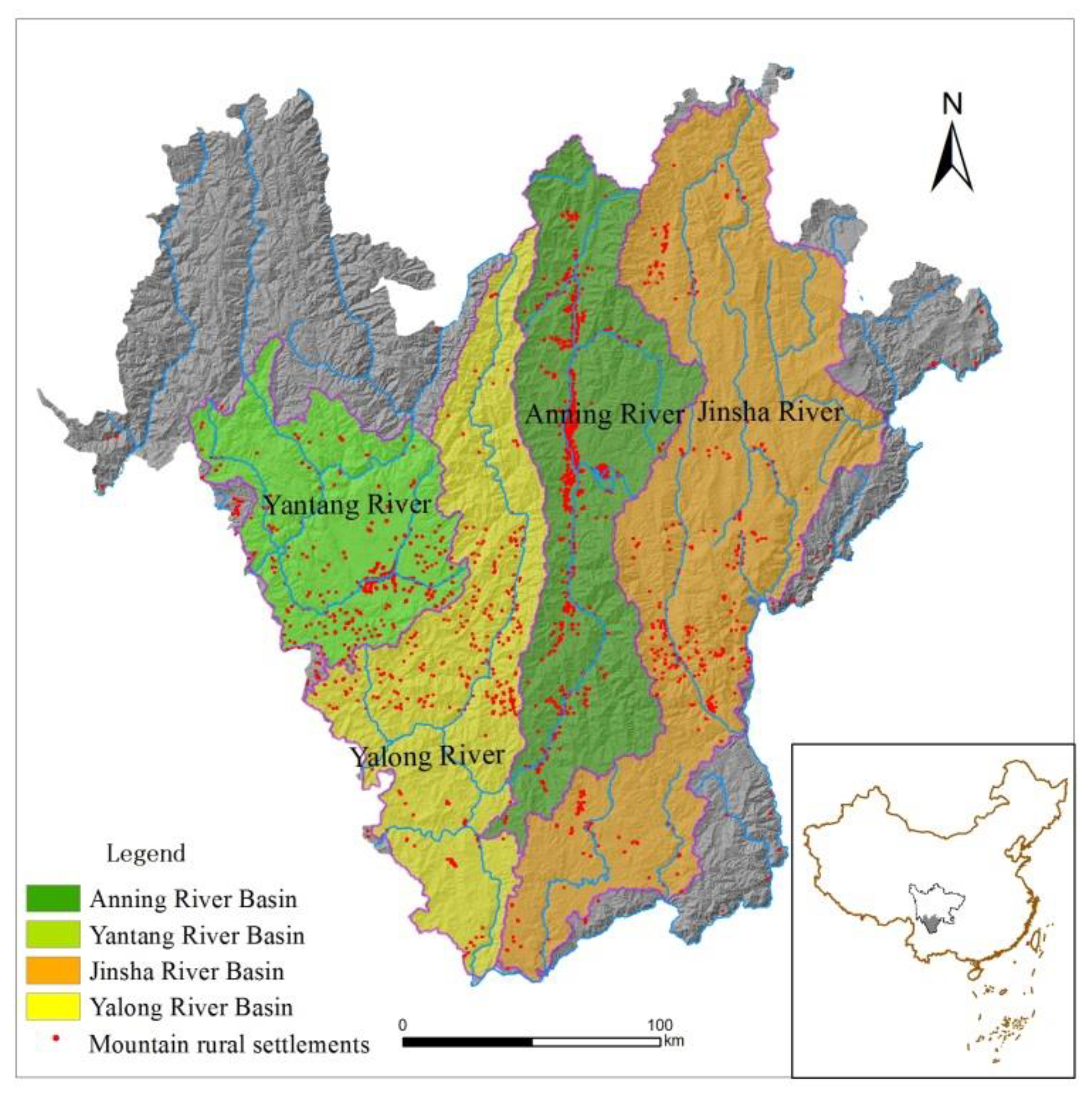
2. Study Region and Data Sources
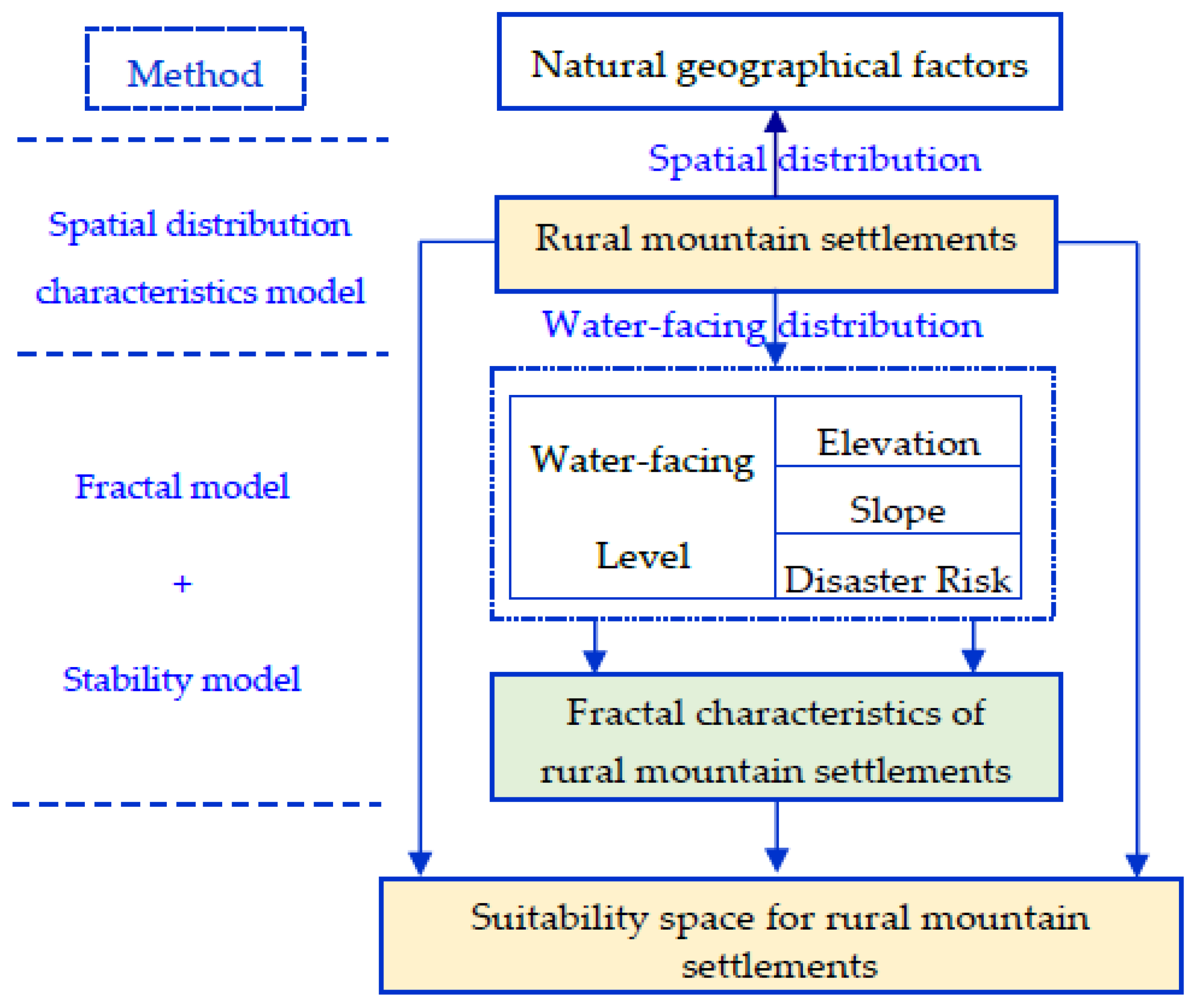
3. Methods
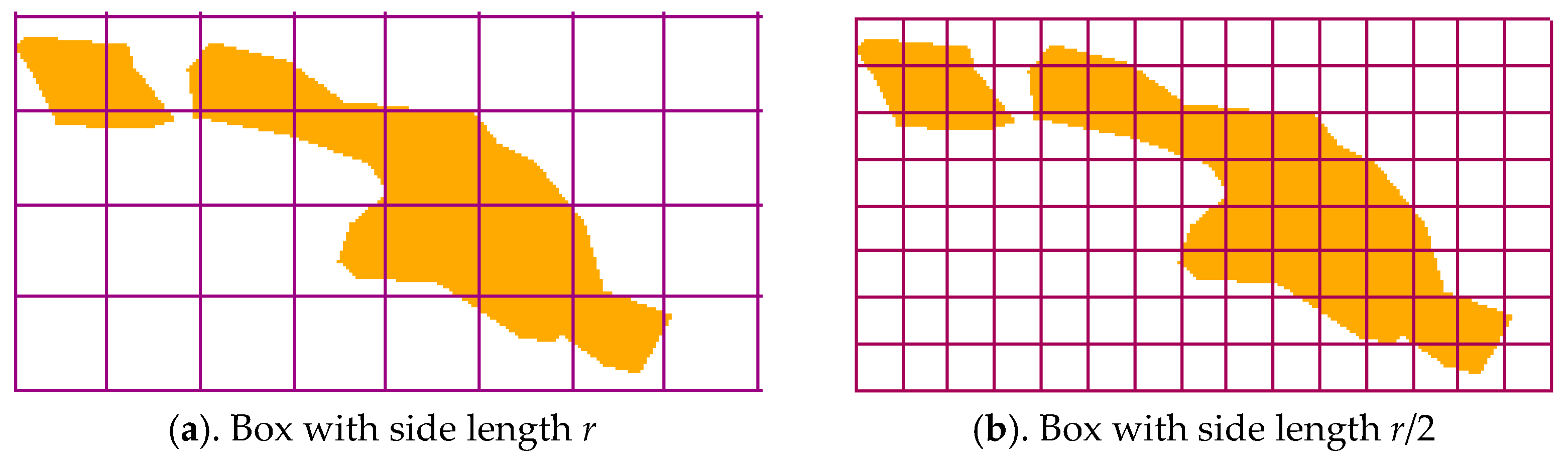
3.1. Fractal Model
3.2. Spatial Distribution Characteristics Model
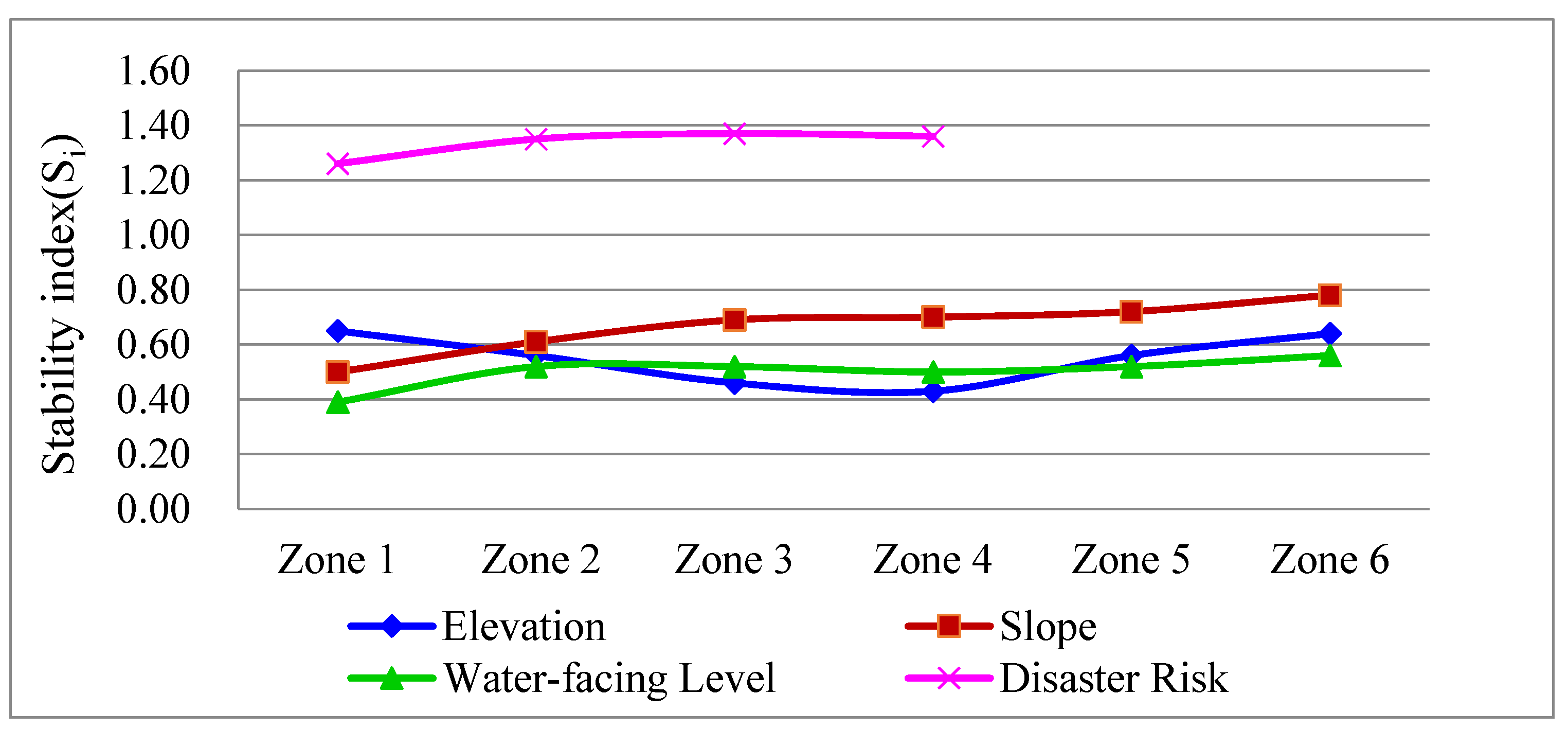
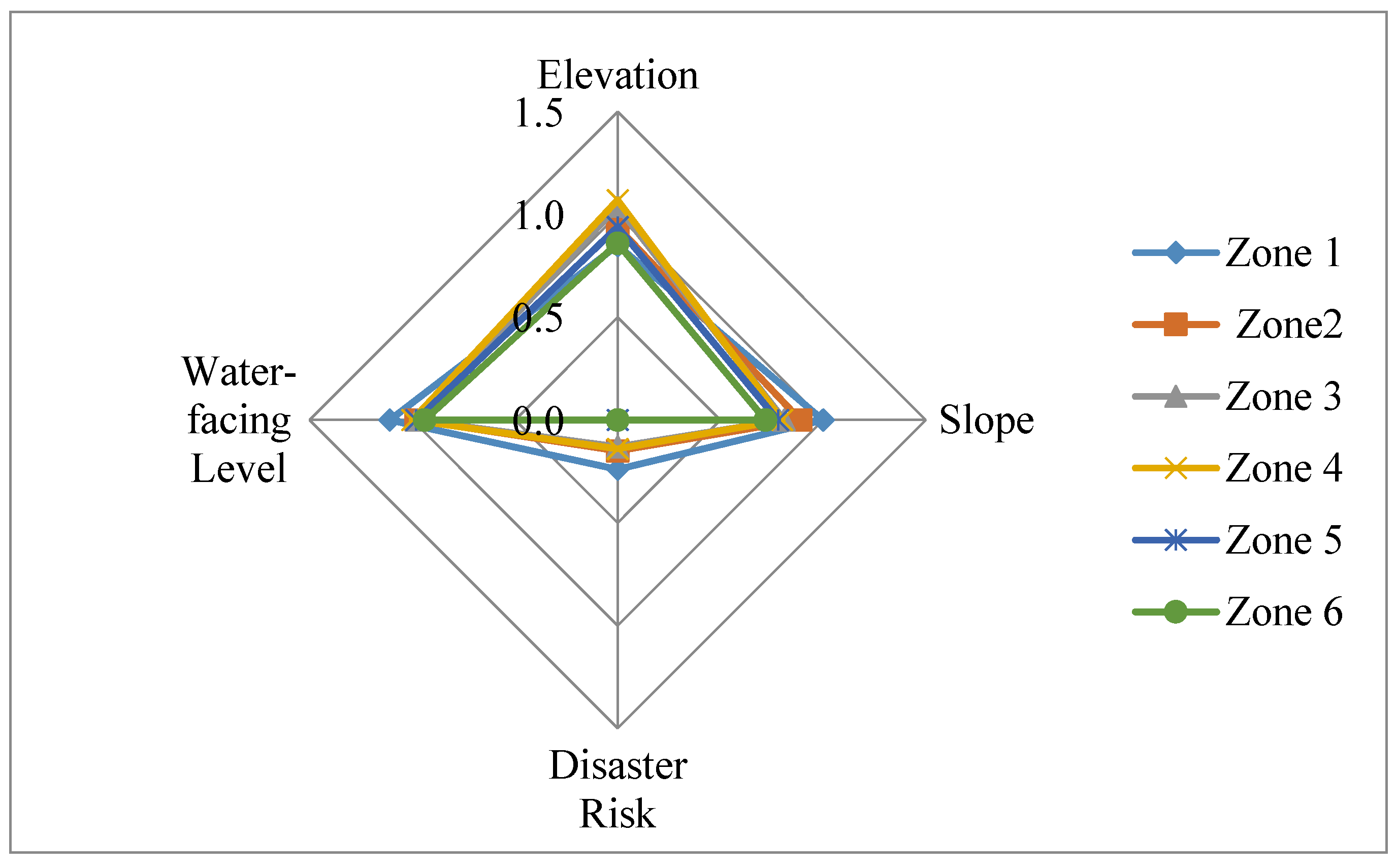
3.3. Stability Model
3.4. Grading Standards
4. Results
4.1. Spatial Distribution Characteristics of Rural Settlements on Natural Geographical Factors
4.2. Water-Facing Distribution of Rural Mountain Settlements
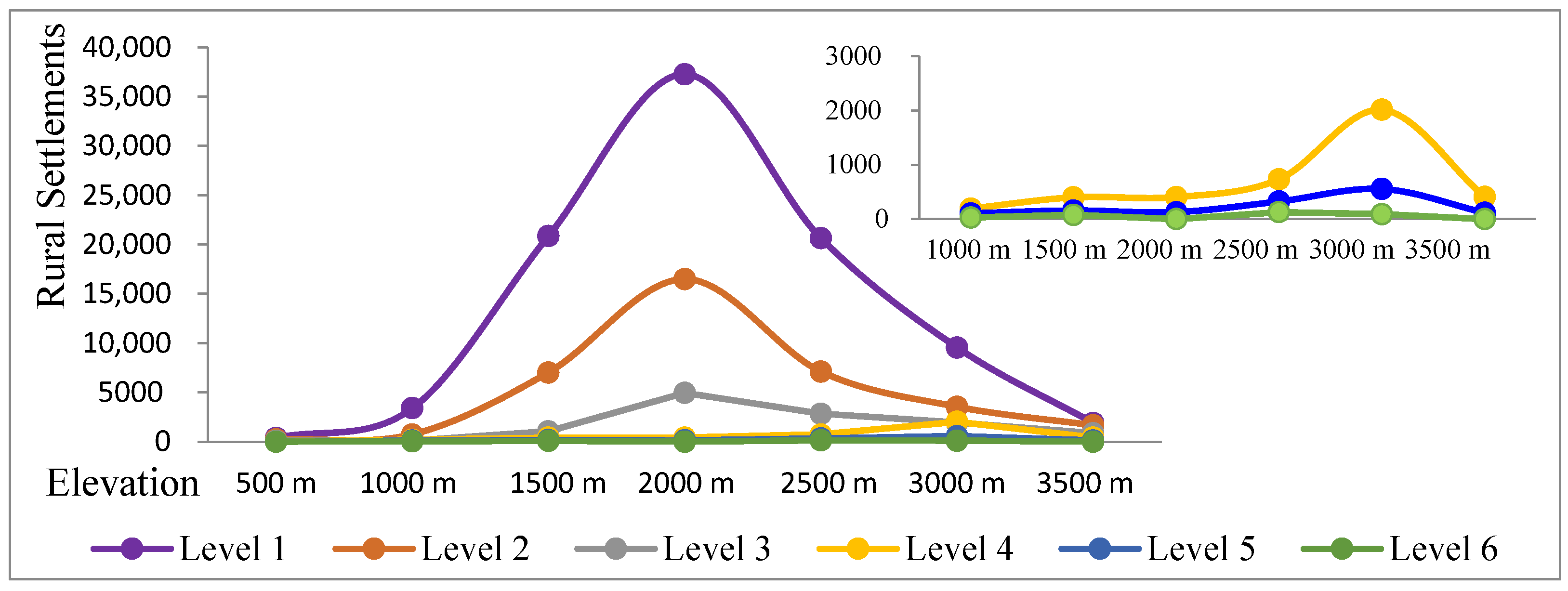
4.2.1. Water-Facing Distribution of Rural Mountain Settlements in Terms of Elevation
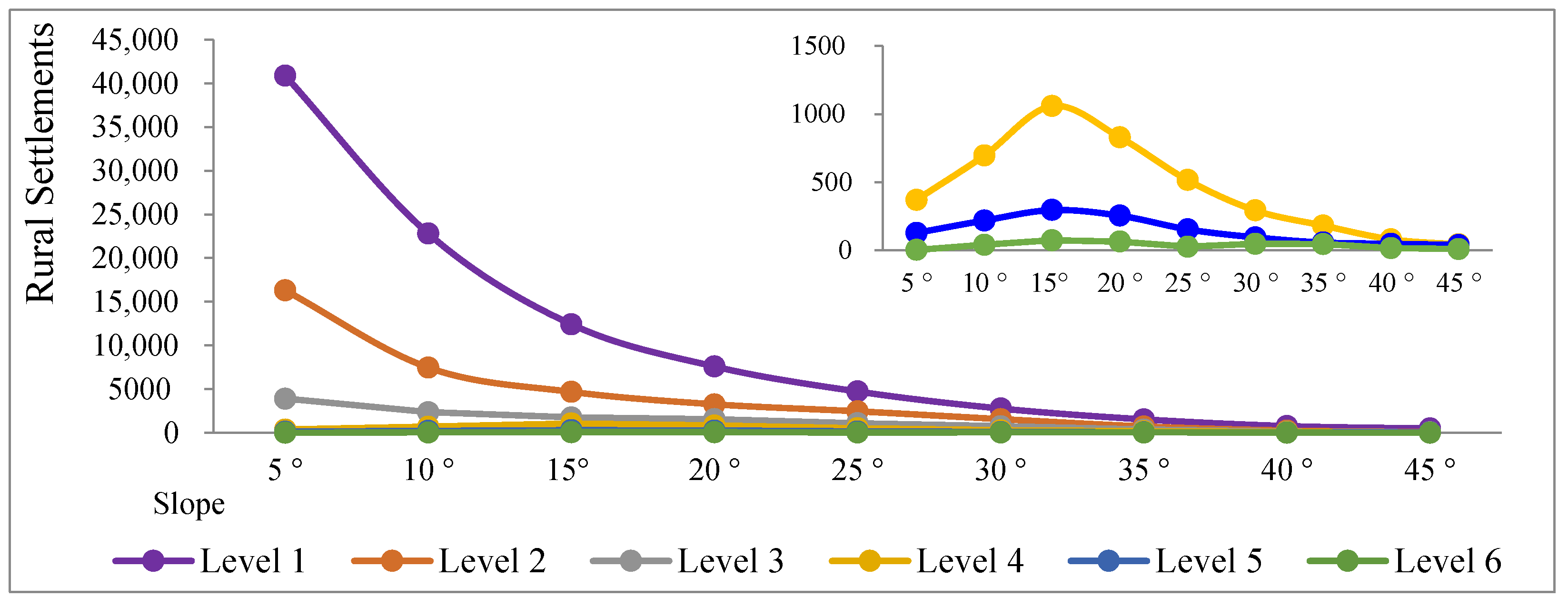
4.2.2. Water-Facing Distribution of Rural Mountain Settlements in Terms of Slope
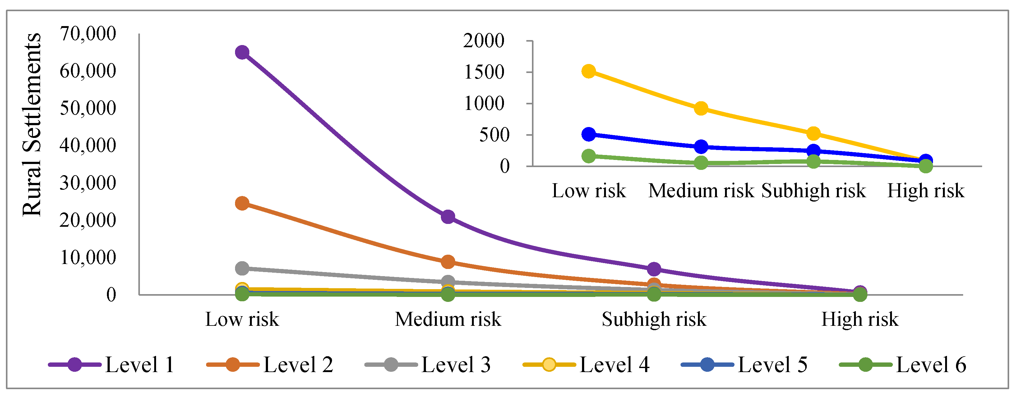
4.2.3. Water-Facing Distribution of Rural Mountain Settlements in Terms of Disaster Risk
4.3. Fractal Dimension Value of Rural Mountain Settlements
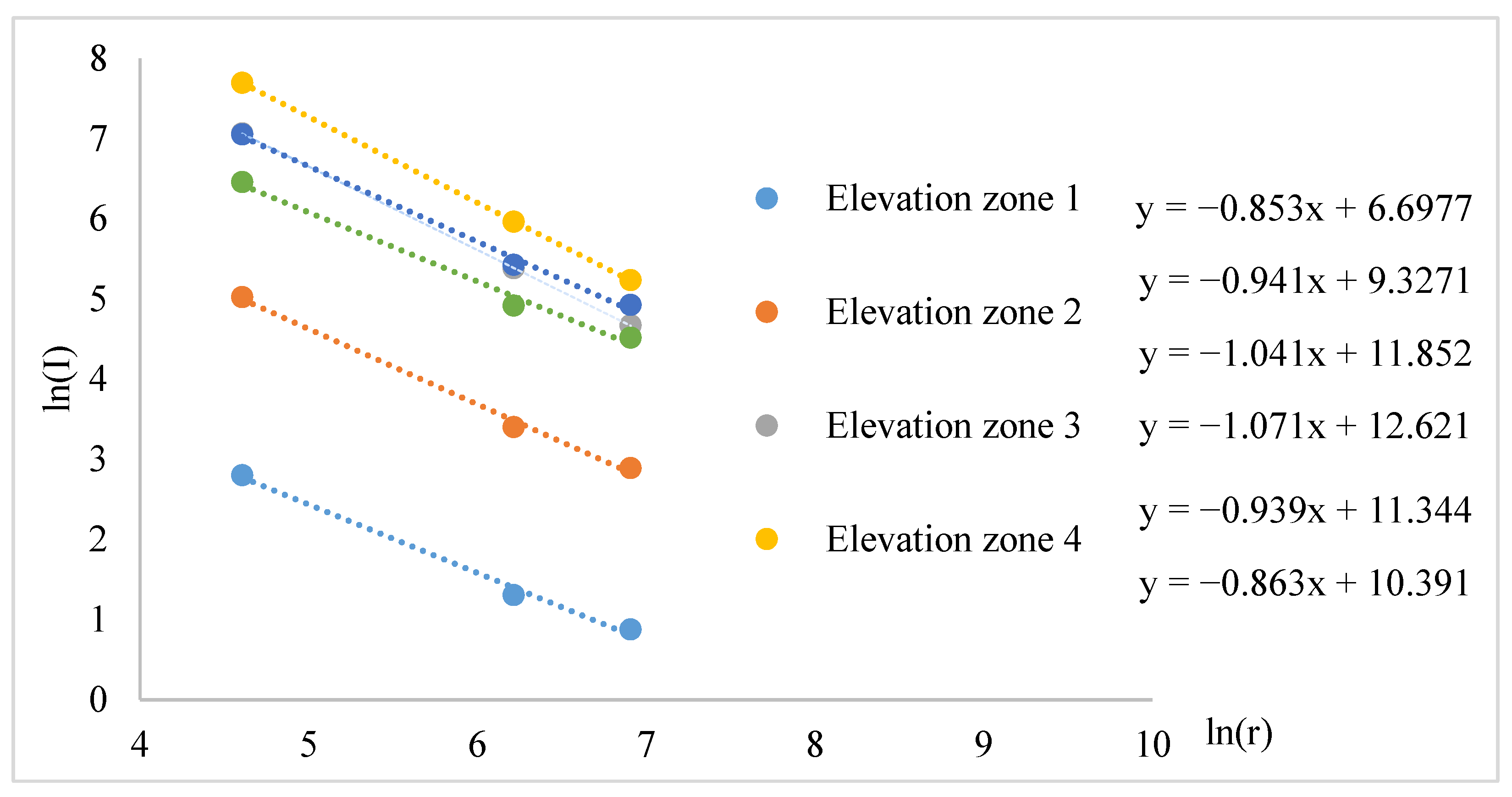
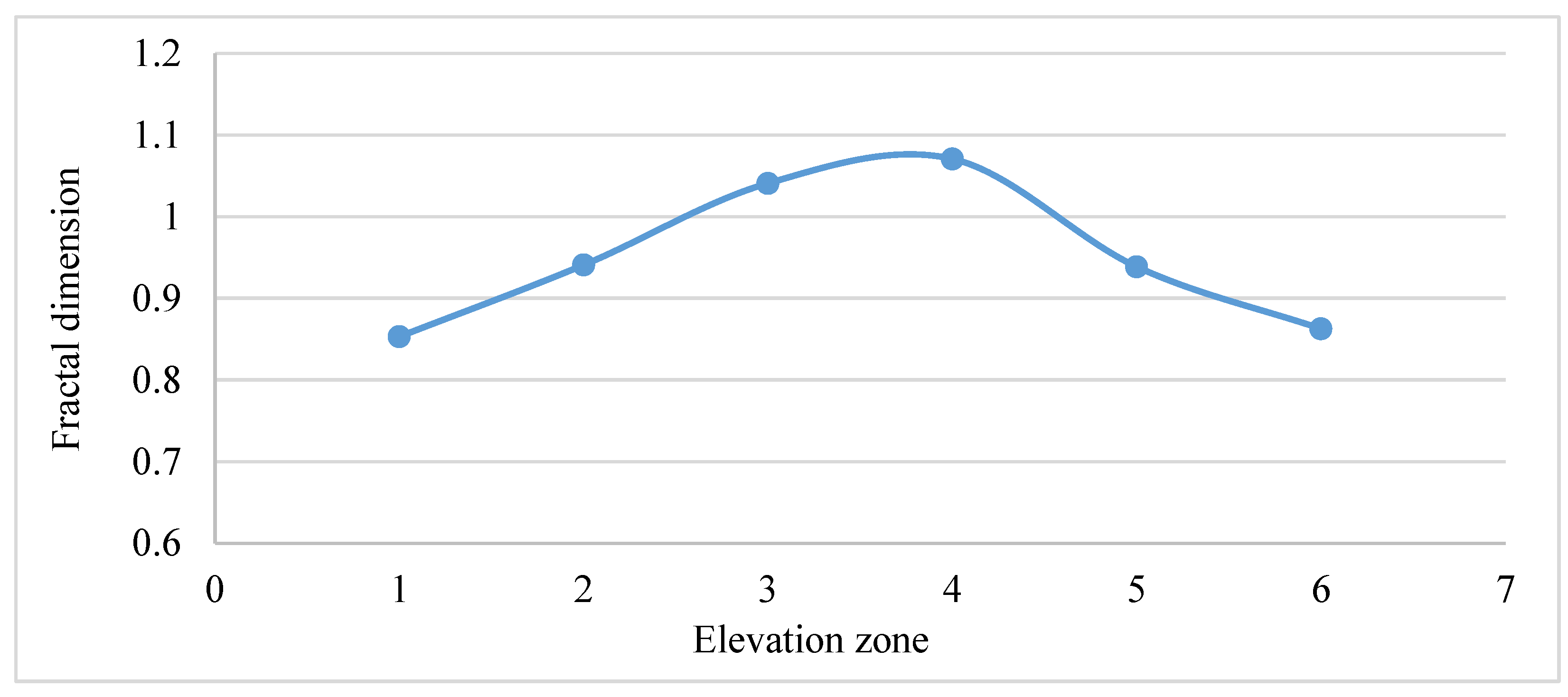
4.3.1. Fractal Characteristics of Rural Mountain Settlements in Terms of Elevation
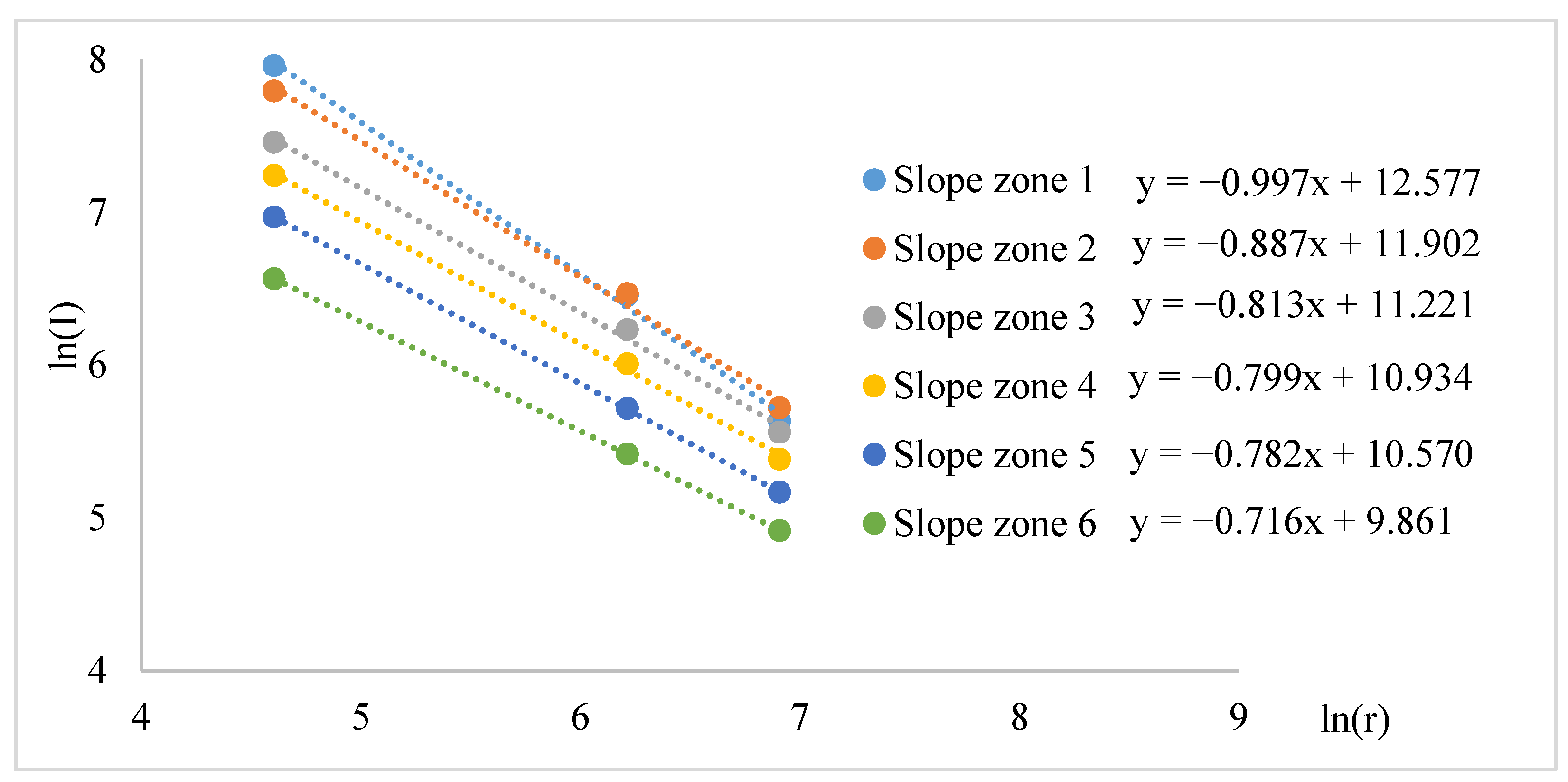
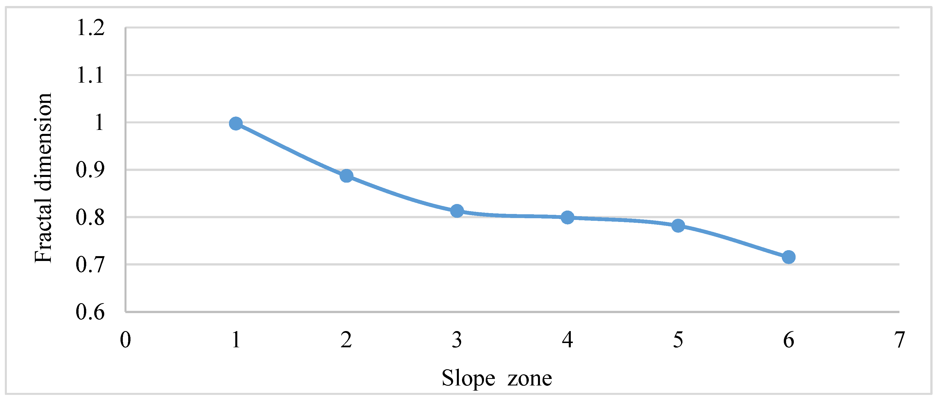
4.3.2. Fractal Characteristics of Rural Mountain Settlements on Slope
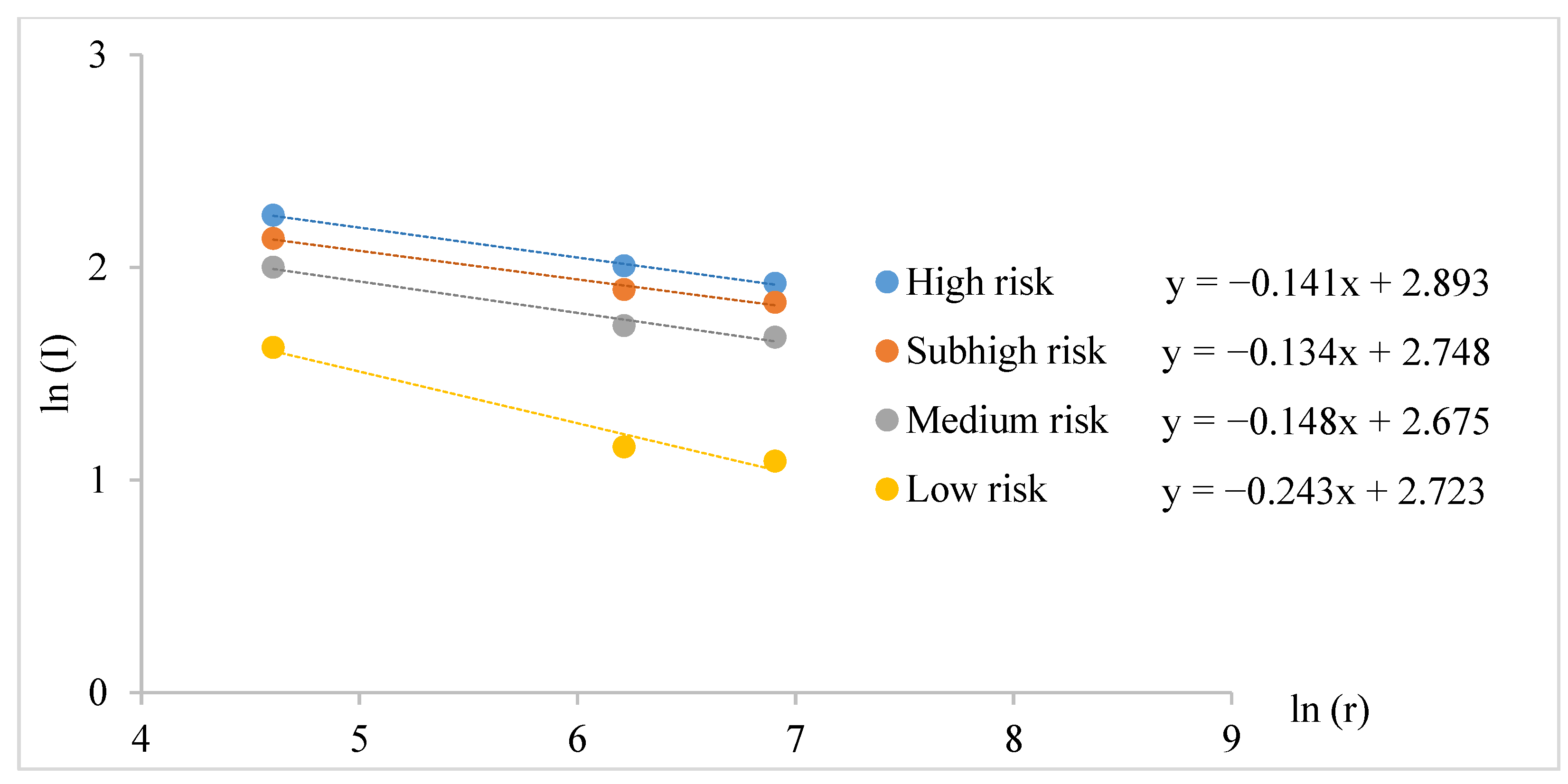
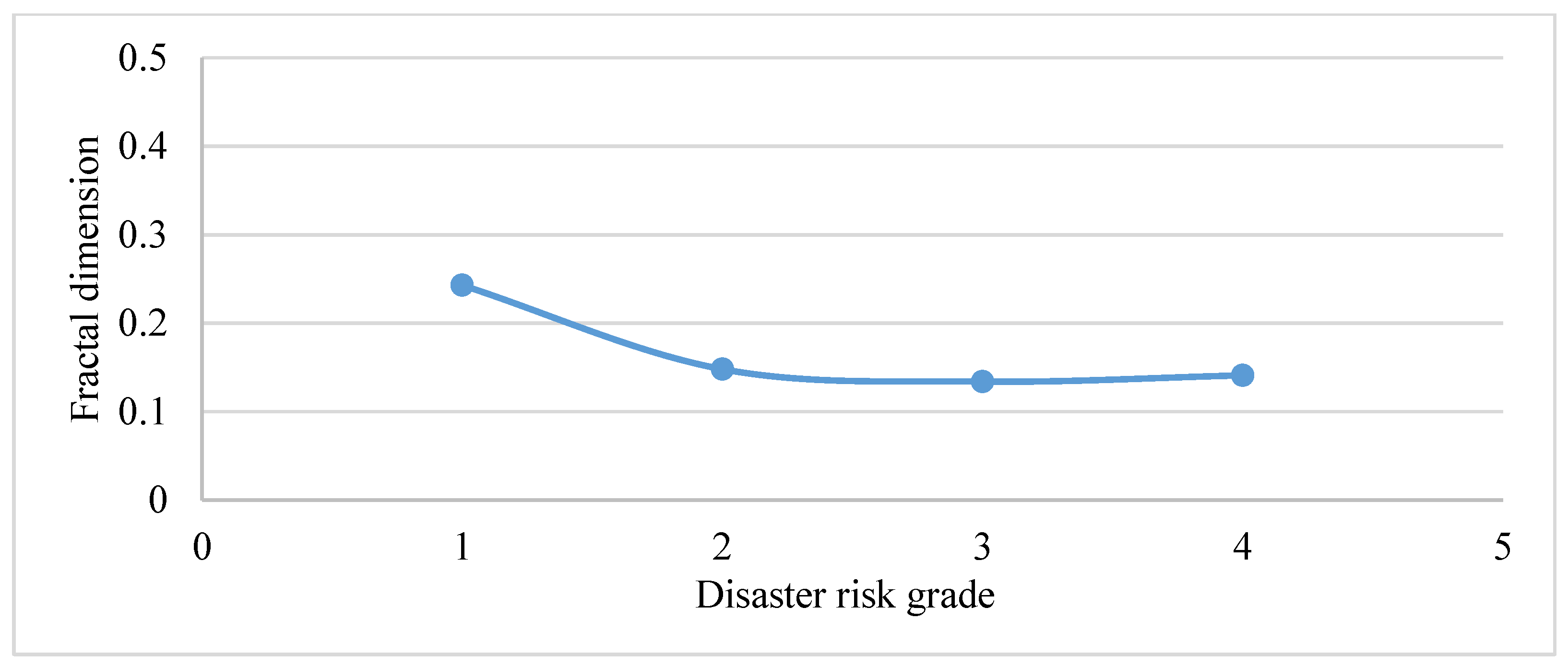
4.3.3. Fractal Characteristics of Rural Mountain Settlements on Disaster Risk Zone
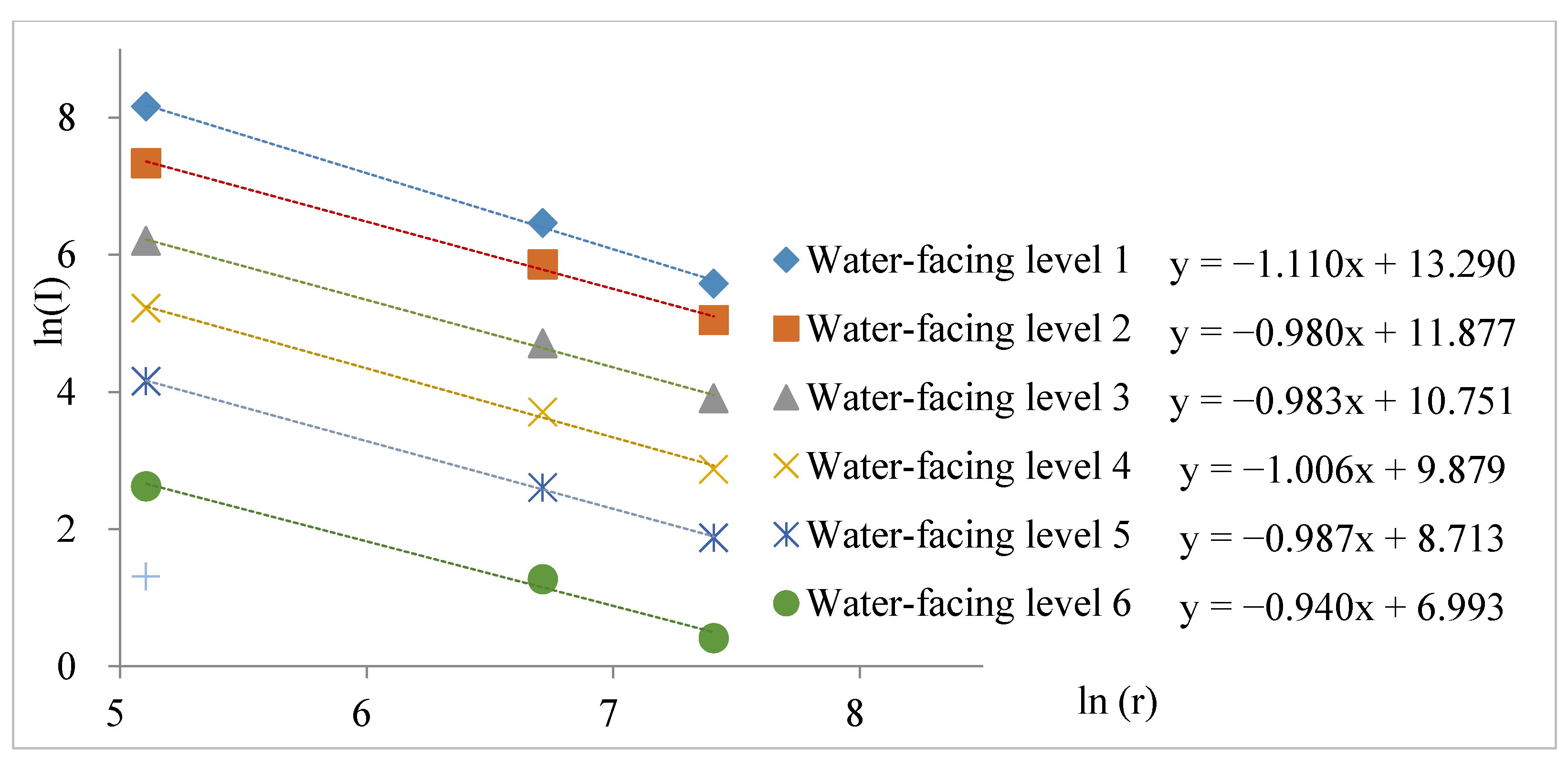
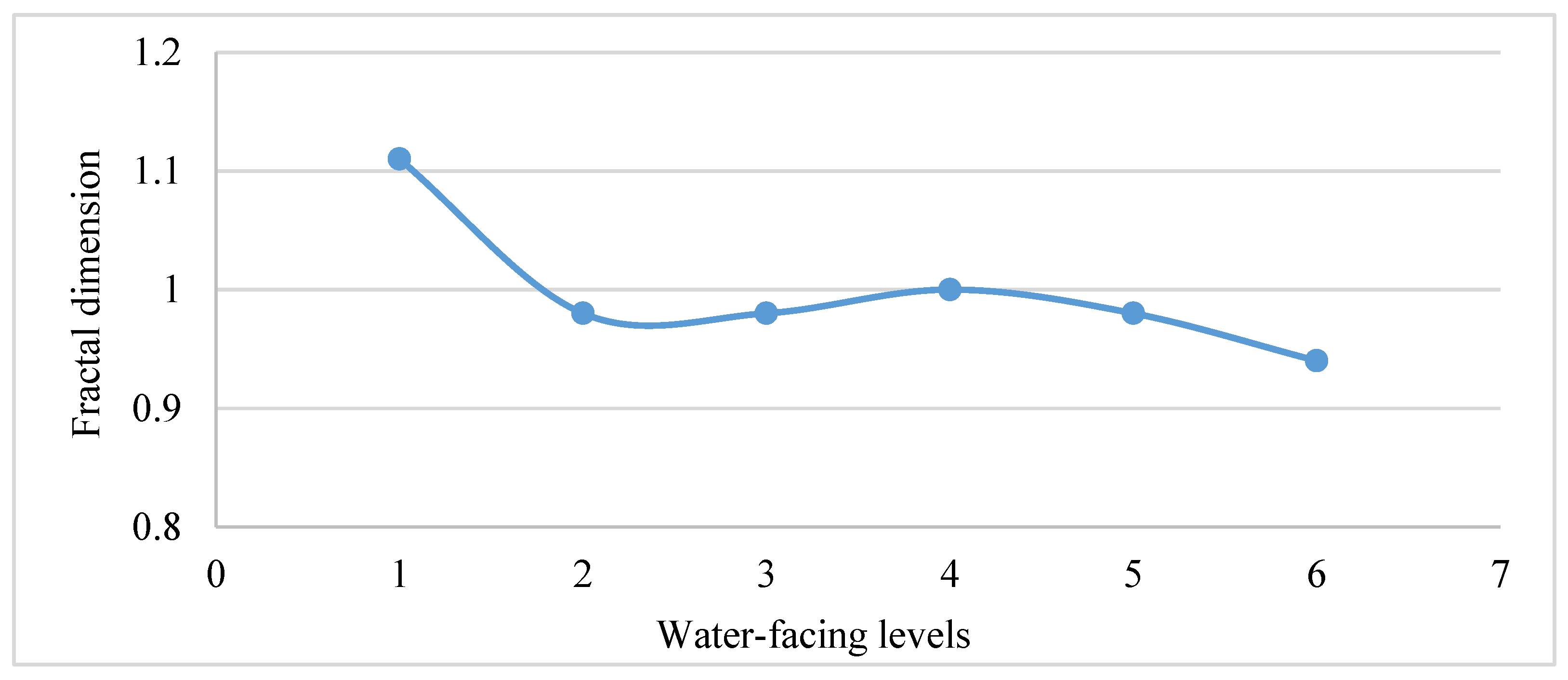
4.3.4. Fractal Characteristics of Rural Mountain Settlements in Terms of Water-Facing Level
5. Discussion
5.1. Water Systems Affect the Distribution of Rural Mountain Settlements
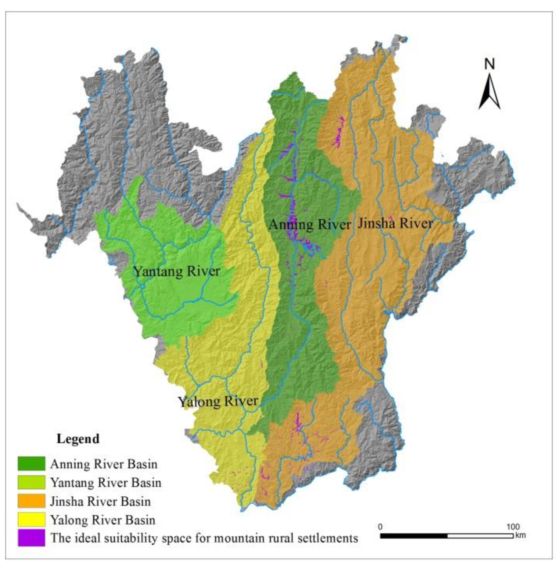
5.2. Suitability Space for Rural Mountain Settlements
6. Conclusions
Author Contributions
Funding
Institutional Review Board Statement
Informed Consent Statement
Data Availability Statement
Conflicts of Interest
References
- Ma, Y.X.; Zhang, J.M.; Wang, L.H. City-size distribution and allometric growth in Xinjiang based on fractal theory. Aird Land Geogr. 2018, 41, 661–667. [Google Scholar]
- Zhuang, Z.F.; Jiang, G.H.; He, X.; Qu, Y.B.; Zhang, C.Y. Study on Spatial Structure and Form of Rural Residential Based on Fractal Theory: A Case Study on Pinggu District in Beijing. J. Nat. Resour. 2015, 30, 1534–1545. [Google Scholar]
- Qie, R.Q.; Liu, F.M. Study on changes in landscape pattern of landuse based on fractal theory—A case study of Zhenlai Town of Zhenlai County. Res. Soil Water Conserv. 2013, 20, 217–222. [Google Scholar]
- Xu, J.H. Mathematical Methods in Contemporary Geography, 2nd ed.; Higher Education Press: Beijing, China, 2012. [Google Scholar]
- Chen, Y.; Huang, L. Modeling fractal dimension curve of Urban growth in developing countries. Chaos Solitons Fractals 2016, 45, 115–124. [Google Scholar] [CrossRef]
- Tannier, C.; Thomas, I. Defining and characterizing urban boundaries: A fractal analysis of theoretical cities and Belgian cities. Comput. Environ. Urban Syst. 2013, 41, 234–248. [Google Scholar] [CrossRef]
- Zhang, H.; Li, Z. Fractality and Self-Similarity in the Structure of Road Networks. Ann. Assoc. Am. Geogr. 2012, 102, 350–365. [Google Scholar] [CrossRef]
- Lu, Z.M.; Zhang, H.; Southworth, F.; Crittendena, J. Fractal dimensions of metropolitan area road networks and the impacts on the urban built environment. Ecol. Indic. 2016, 70, 285–296. [Google Scholar] [CrossRef]
- Cheng, S.M. A Fractal Study on the Urban System of Qinba Mountain in Sichuan. Sci. Technol. Manag. Land Resour. 2016, 33, 108–114. [Google Scholar]
- Che, M.L. Fractal geometry of rural residential areas in Pingyi County Mountains and impact factors. Trans. Csae 2010, 26, 360–365. [Google Scholar]
- Song, Z.J.; Guan, X.K.; Zhu, Z.Q. The Spatial Fractal Characteristics and Complexity of Rural Residential Areas in Beijing. Sci. Geogr. Sin. 2013, 33, 52–60. [Google Scholar]
- Cronon, W. Nature’s Metropolis: Chicago and the Great West; Norton: New York, NY, USA, 1991. [Google Scholar]
- Berziant, M.; Konishi, H. The Endogenous Formation of a City: Population Agglomeration and Market Places in a Location-Specific Production Economy. Reg. Sci. Urban Econ. 2000, 30, 289–324. [Google Scholar] [CrossRef]
- Liu, Q.P. Quantitative Study of the Relationship between the Distribution of Cities and the Natural Environment Based on GIS and RS in China. Sci. Geogr. Sin. 2012, 32, 687–693. [Google Scholar]
- Wang, Y.; Guo, H.B.; Yang, Q.Y. Analyzing land use characteristics of rural settlements on the urban fringe of Liangjiang New Area, Chongqing, China. J. Mt. Sci. 2016, 13, 1855–1866. [Google Scholar] [CrossRef]
- Li, S.S.; Cao, G.C.; Zhao, P.F. Analysis of spatial distribution of rural settlements and its influential factors in Qinba mountain area—A case study of Ningqiang county in Shaanxi probince. Res. Soil Water Conserv. 2014, 21, 186–191. [Google Scholar]
- Qiang, M.; Yu, H. The Distribution Relationship Between Mountain Rivers and Rural Settlements in Panxi Area Based on The Fractal Theory. Jiangsu Agric. Sci. 2019, 47, 337–341. [Google Scholar]
- Mo, T. Risk Assessment of Debris Flow Based on Watershed in Panxi Area; Nanjing University of Information Science & Technology: Nanjing, China, 2015. [Google Scholar]
- Luo, H.L.; Ran, M.Y. Discussion on the sustainable utilization of water resources in Panxi Area. J. Nat. Resour. 2001, 16, 552–556. [Google Scholar]
- Liu, X.N.; Xu, H.M.; Huang, F. Study on Graphic Information Characteristics of Land Use Spatial Pattern and Its Change. Sci. Geogr. Sin. 2002, 22, 79–84. [Google Scholar]
- Chen, X.J.; Zhang, H.Y.; Liu, Q.S. Spatial Pattern of Non-Agricultural Land in the Urban Fringe of Beijing. Resour. Sci. 2004, 26, 2–4. [Google Scholar]
- Xu, J.H.; Ai, N.S.; Jin, J.; Fan, S.Y. A Fractal Study on the Mosaic Structure of the Landscape of Northwest China- Taking the Drainage Area of Heihe River as an Example. Arid Zone Res. 2001, 18, 35–39. [Google Scholar]
- Li, Y.H. Analysis on fractal characteristics of rural settlements in Chongqing and its influencing factors. Trans. CSAE 2014, 30, 225–232. [Google Scholar]


| Influencing Factors | Zone 1 | Zone 2 | Zone 3 | Zone 4 | Zone 5 | Zone 6 |
|---|---|---|---|---|---|---|
| Elevation (m) | ≤500 | 500–1000 | 1000–1500 | 1500–2000 | 2000–2500 | 2500–3000 |
| Slope (°) | ≤5° | 5–10° | 10–15° | 15–20° | 20–25° | 25–30° |
| Disaster Risk | Low risk | Medium risk | Sub-high risk | High risk | / | / |
| Water-facing Level (m) | ≤500 | 500–1000 | 1000–1500 | 1500–2000 | 2000–2500 | 2500–3000 |
Publisher’s Note: MDPI stays neutral with regard to jurisdictional claims in published maps and institutional affiliations. |
© 2021 by the authors. Licensee MDPI, Basel, Switzerland. This article is an open access article distributed under the terms and conditions of the Creative Commons Attribution (CC BY) license (http://creativecommons.org/licenses/by/4.0/).
Share and Cite
Yu, H.; Luo, Y.; Li, P.; Dong, W.; Yu, S.; Gao, X. Water-Facing Distribution and Suitability Space for Rural Mountain Settlements Based on Fractal Theory, South-Western China. Land 2021, 10, 96. https://doi.org/10.3390/land10020096
Yu H, Luo Y, Li P, Dong W, Yu S, Gao X. Water-Facing Distribution and Suitability Space for Rural Mountain Settlements Based on Fractal Theory, South-Western China. Land. 2021; 10(2):96. https://doi.org/10.3390/land10020096
Chicago/Turabian StyleYu, Hui, Yong Luo, Pengshan Li, Wei Dong, Shulin Yu, and Xianghe Gao. 2021. "Water-Facing Distribution and Suitability Space for Rural Mountain Settlements Based on Fractal Theory, South-Western China" Land 10, no. 2: 96. https://doi.org/10.3390/land10020096
APA StyleYu, H., Luo, Y., Li, P., Dong, W., Yu, S., & Gao, X. (2021). Water-Facing Distribution and Suitability Space for Rural Mountain Settlements Based on Fractal Theory, South-Western China. Land, 10(2), 96. https://doi.org/10.3390/land10020096