Spatially Explicit Reconstruction of Cropland Using the Random Forest: A Case Study of the Tuojiang River Basin, China from 1911 to 2010
 ,
,
Abstract
1. Introduction
2. Materials and Methods
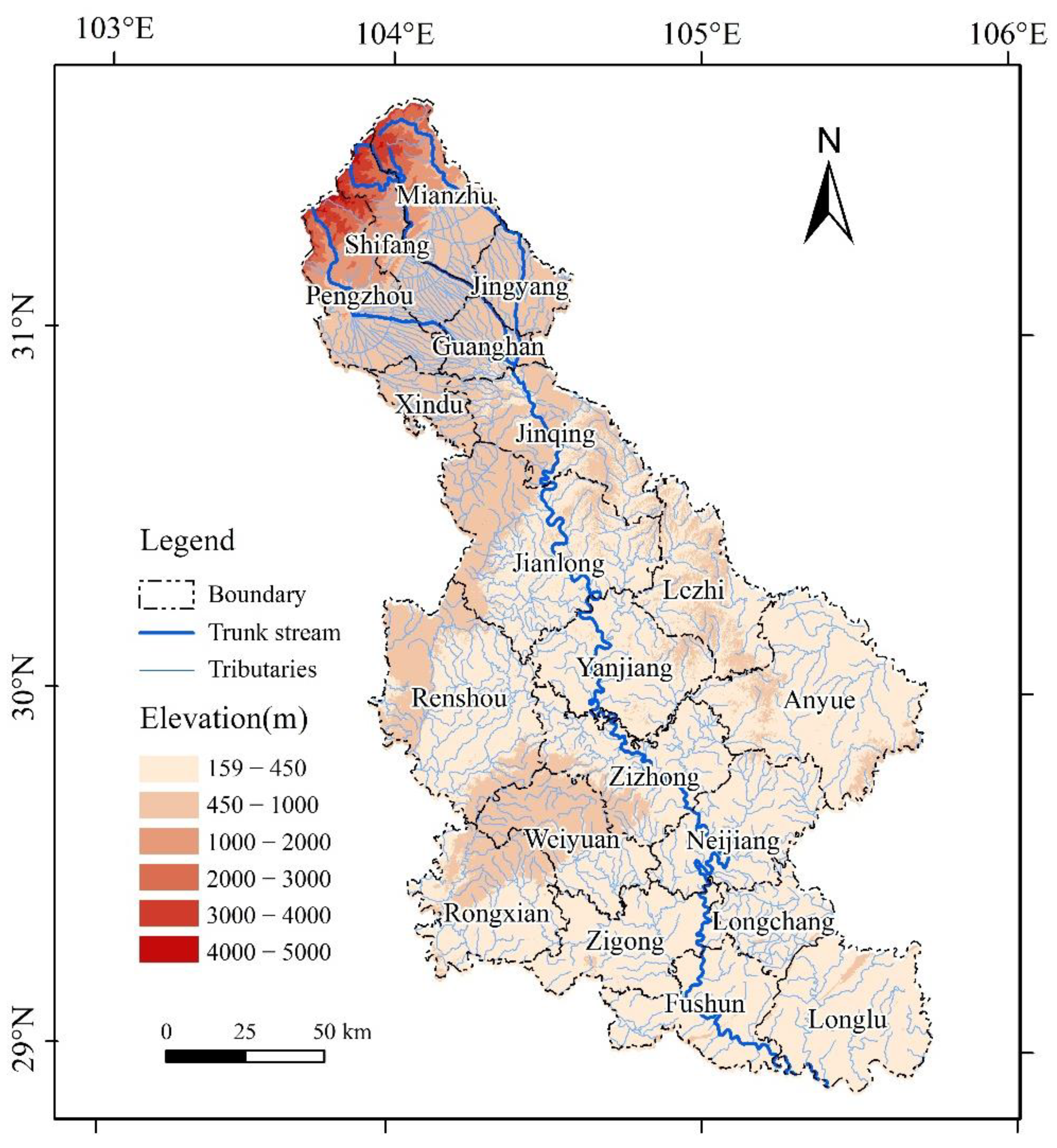
2.1. Study Area
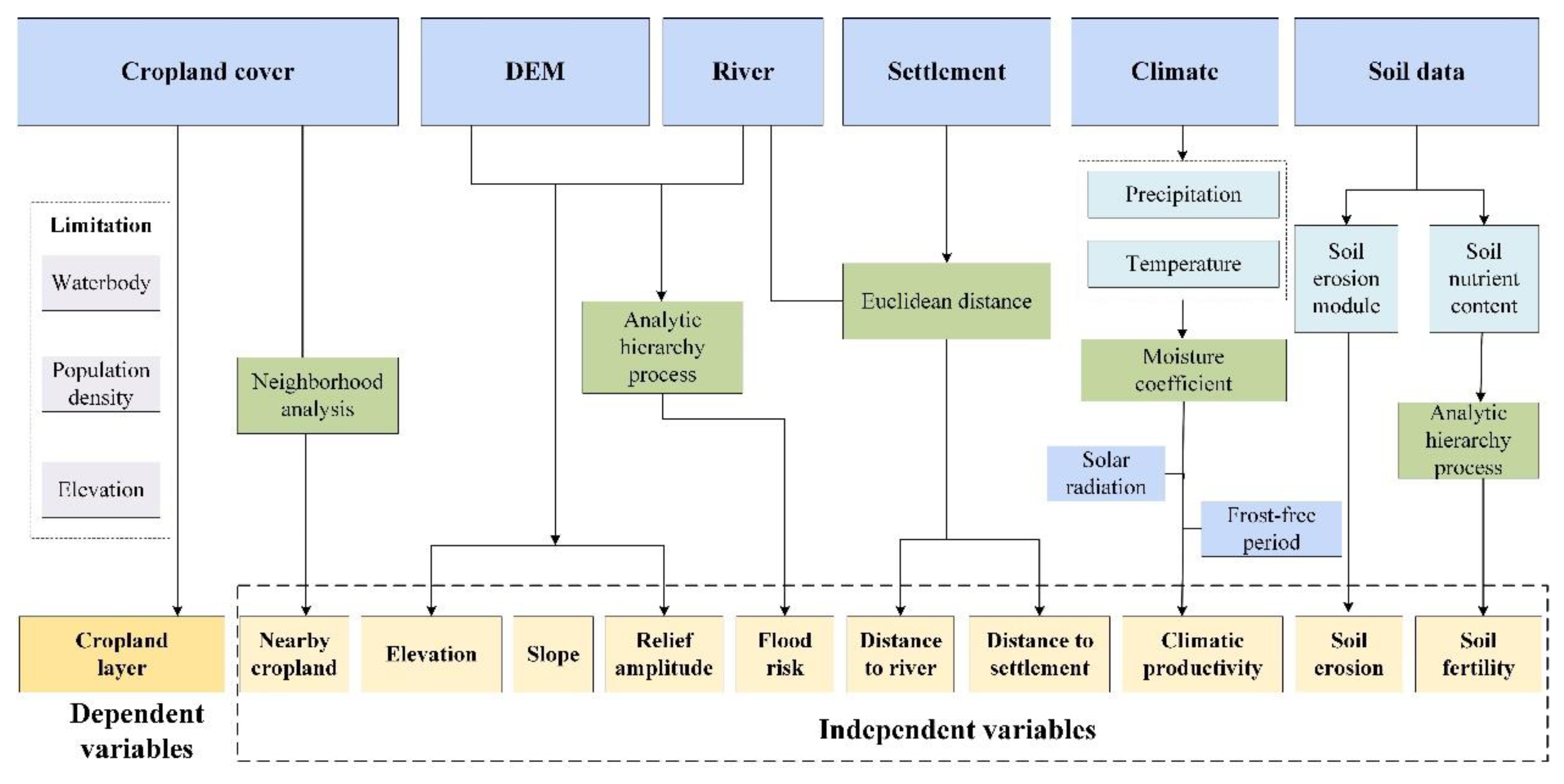
2.2. Input Factors and Data Resources
2.2.1. County-Level Cropland Census
2.2.2. Remotely Sensed Land Use Data
2.2.3. Other Ancillary Data
2.3. Data Preprocessing
2.3.1. Climatic Productive Potential
2.3.2. Soil Fertility
2.3.3. Flood Risk
2.3.4. Distance to Rural Settlements
2.3.5. Time Slice Selection and Cropland Area Calibration
2.3.6. Cropland Data Reconciliation
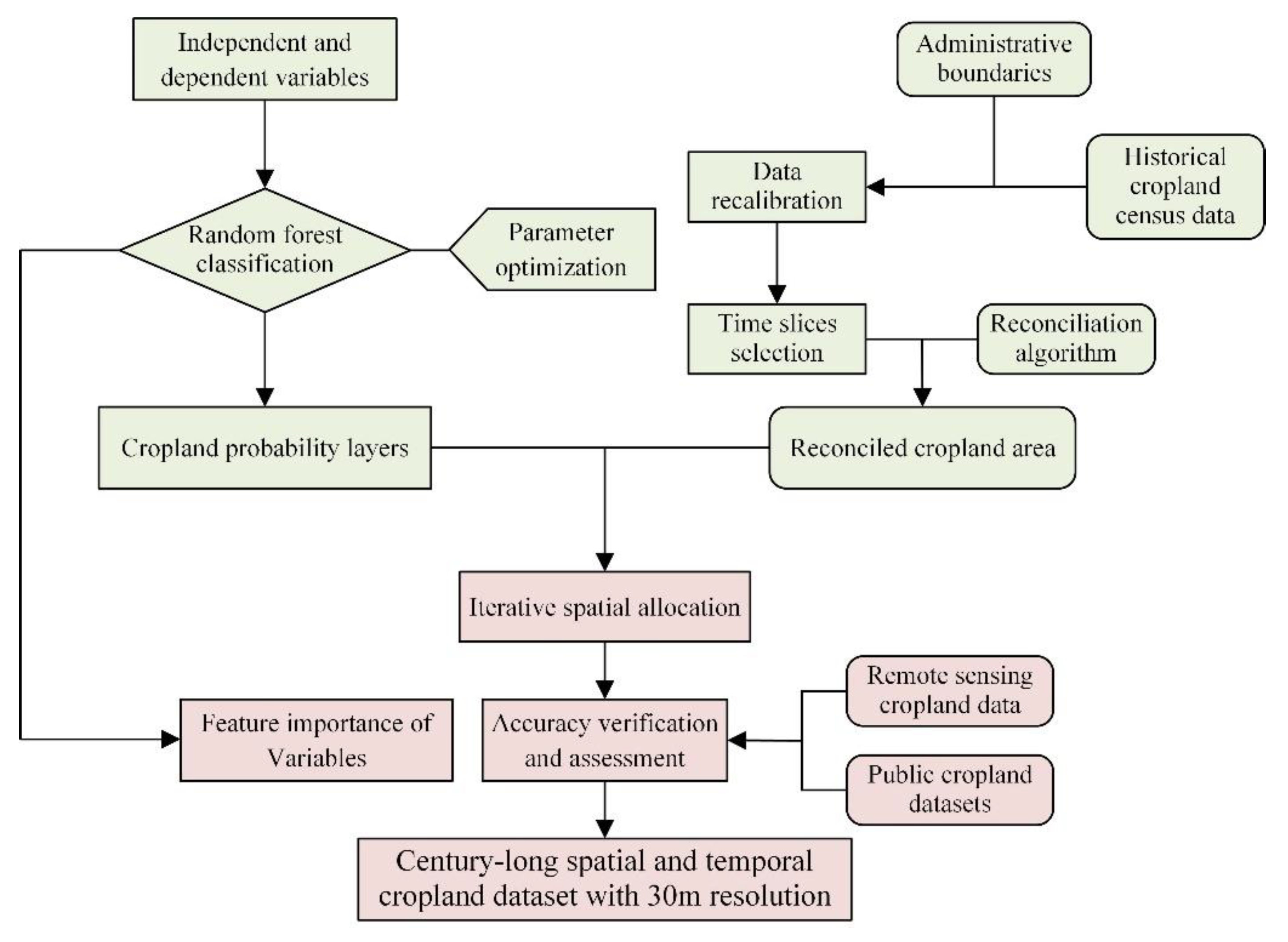
2.4. Cropland Reconstruction Method
2.4.1. Random Forest Classifier Algorithm
2.4.2. RF Model Training
2.4.3. Spatial Allocation of Cropland
2.4.4. Accuracy Assessment
3. Results
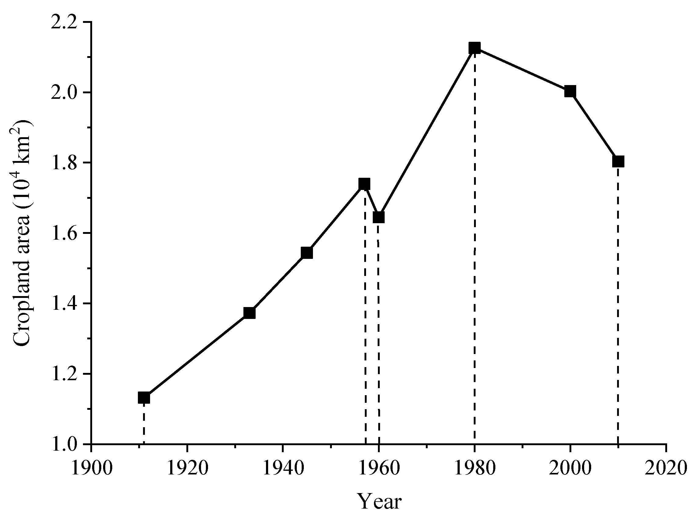
3.1. Changes in Cropland Area during 1911–2010
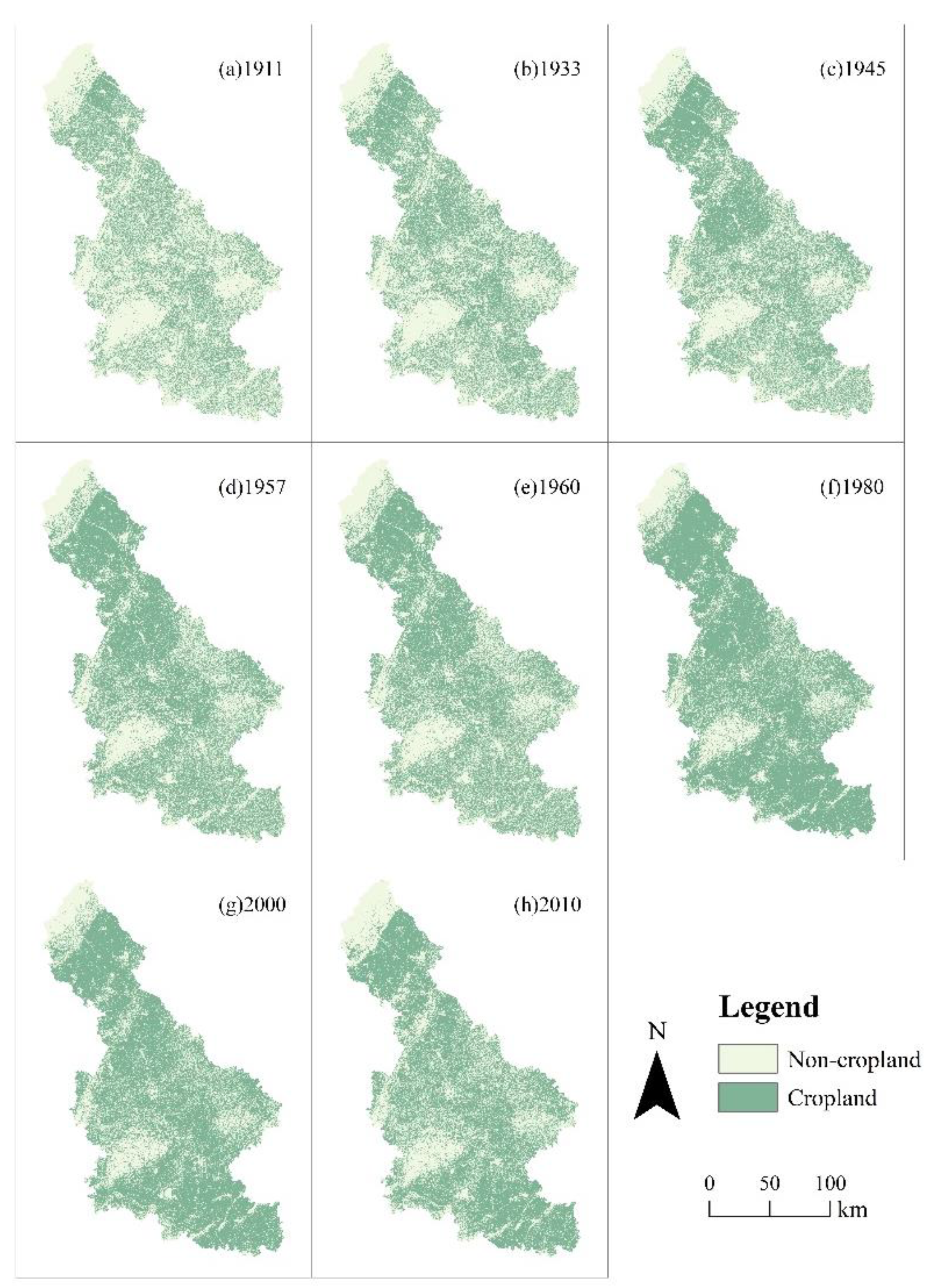
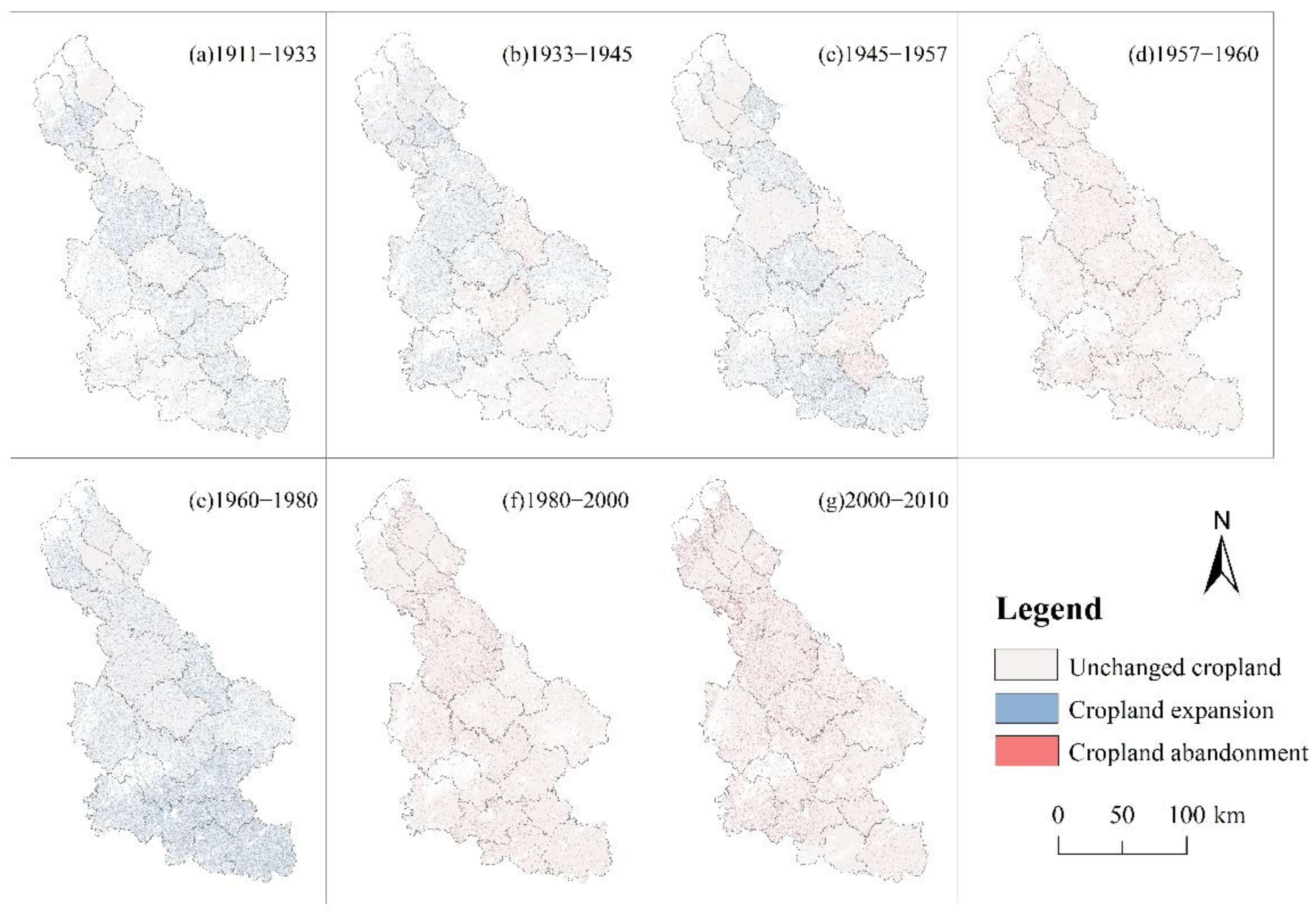
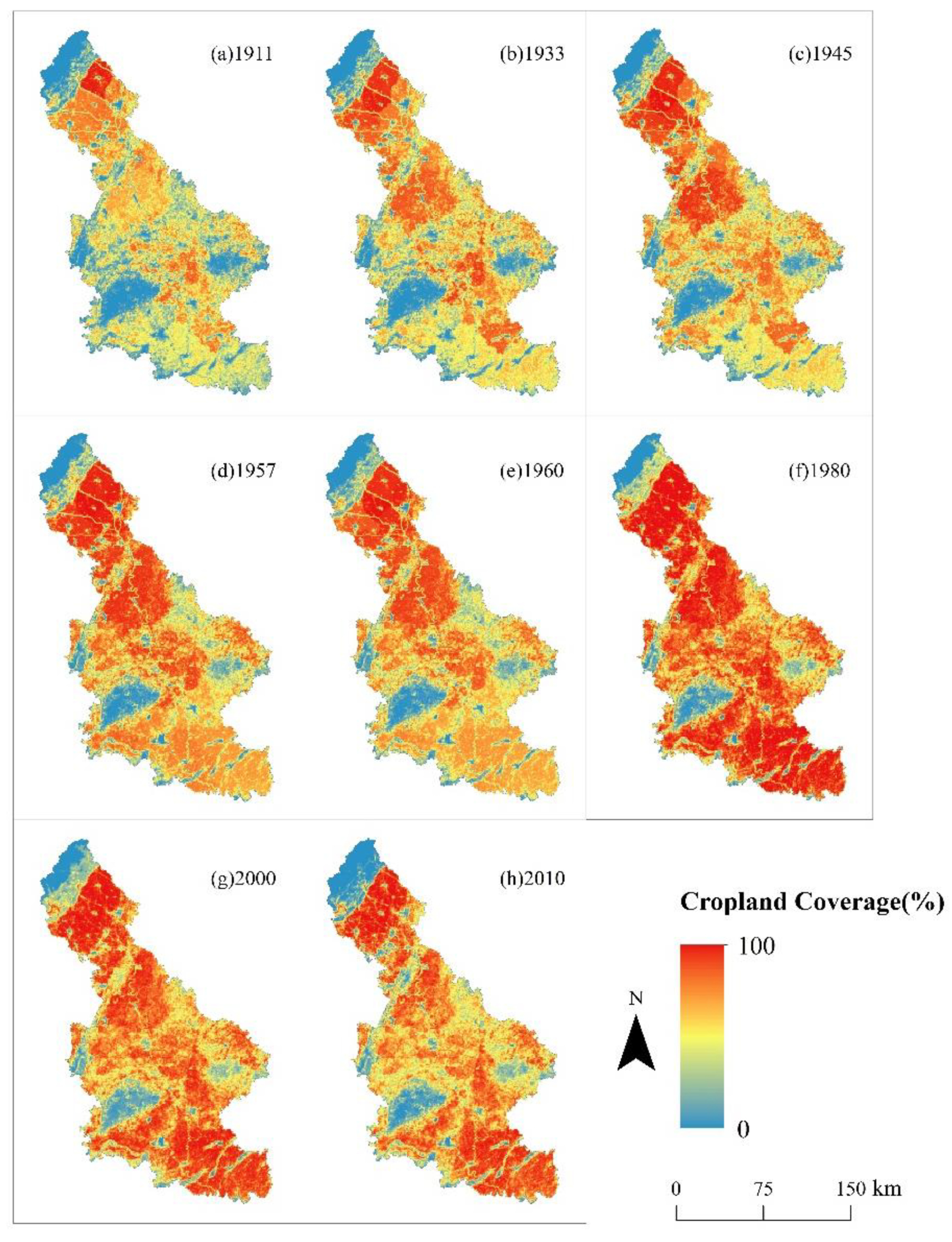
3.2. Spatial Distribution of Cropland Patterns
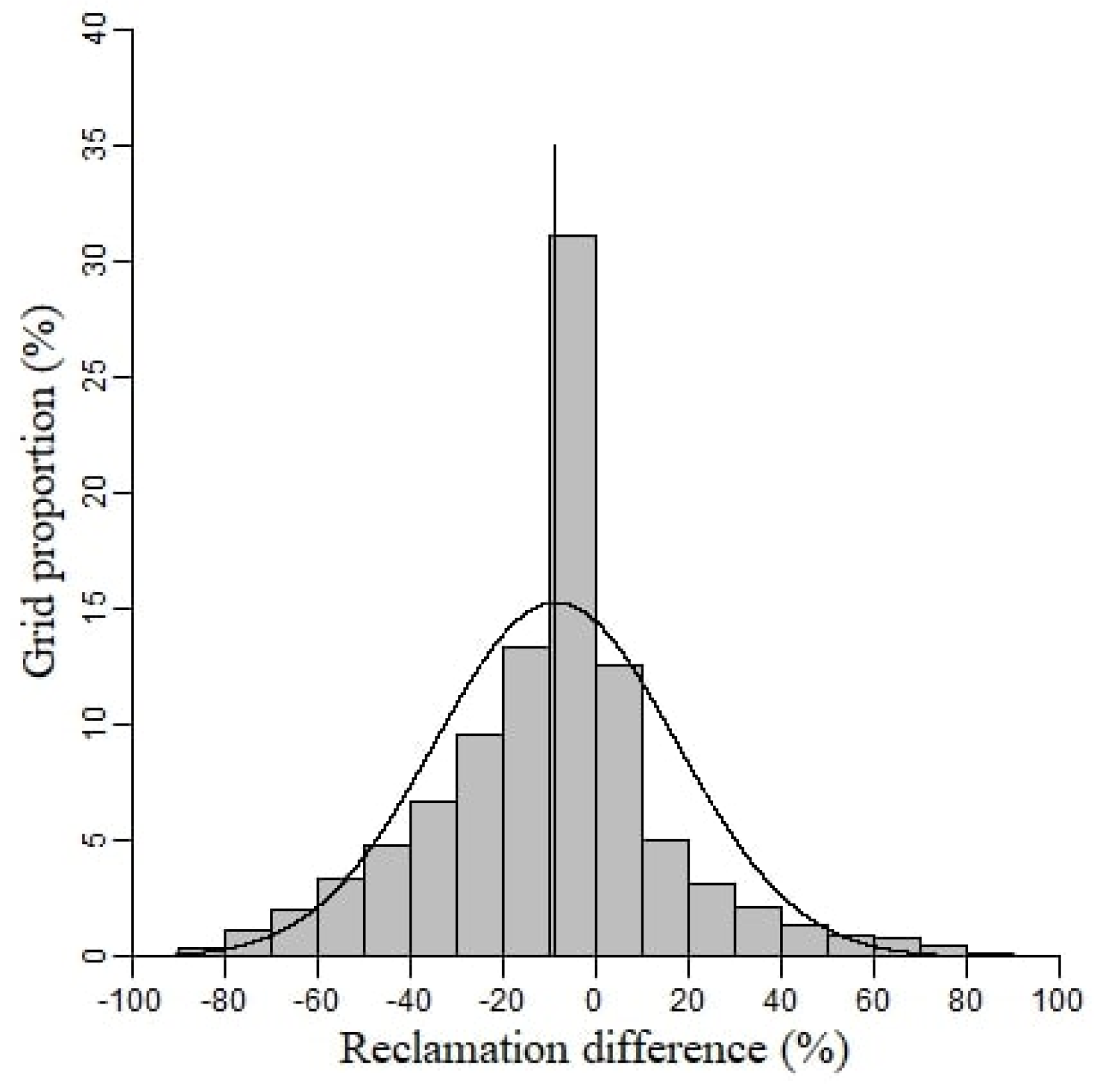
3.3. Verification of Simulation Results
4. Discussion
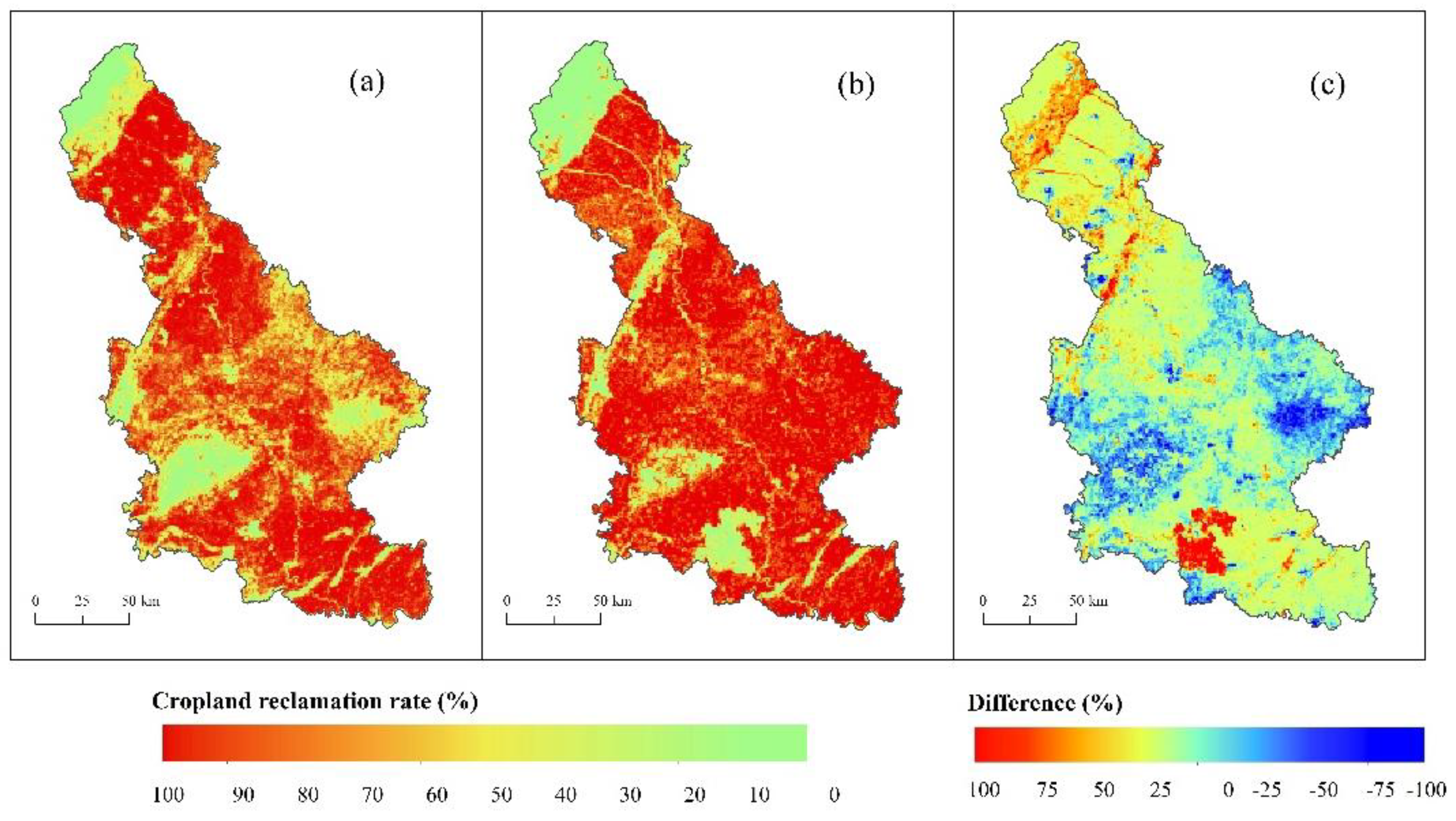
4.1. Comparison to Public Cropland Datasets
4.2. Forces That Drive Cropland Dynamics
4.2.1. Policy Factors and Cropland Area Data
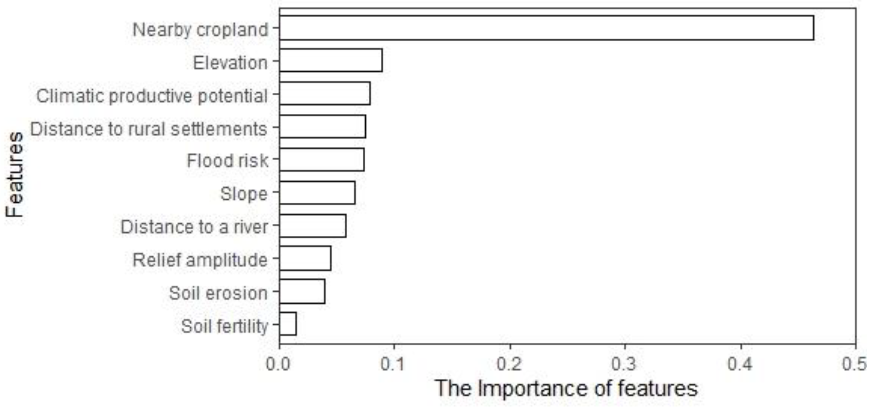
4.2.2. Causes of Cropland Distribution
4.3. Uncertainties and Prospects
5. Conclusions
Supplementary Materials
Author Contributions
Funding
Institutional Review Board Statement
Informed Consent Statement
Data Availability Statement
Acknowledgments
Conflicts of Interest
References
- Lambin, E.F.; Meyfroidt, P. Global land use change, economic globalization, and the looming land scarcity. Proc. Natl. Acad. Sci. USA 2011, 108, 3465–3472. [Google Scholar] [CrossRef] [Scilit] [PubMed]
- Godfray, C.J.; Beddington, J.R.; Crute, I.R.; Haddad, L.; Lawrence, D.; Muir, J.F.; Robinson, S.; Thomas, S.M.; Toulmin, C.; Pretty, J. Food security: The challenge of feeding 9 billion people. Science 2010, 327, 812–818. [Google Scholar] [CrossRef] [Scilit] [PubMed]
- Shi, X.; Wang, W.; Shi, W. Progress on quantitative assessment of the impacts of climate change and human activities on cropland change. J. Geogr. Sci. 2016, 26, 339–354. [Google Scholar] [CrossRef] [Scilit]
- Houghton, R.A. Interactions between land-use change and climate-carbon cycle feedbacks. Curr. Clim. Chang. Rep. 2018, 4, 115–127. [Google Scholar] [CrossRef] [Scilit]
- Molotoks, A.; Stehfest, E.; Doelman, J.; Albanito, F.; Fitton, N.; Dawson, T.P.; Smith, P. Global projections of future cropland expansion to 2050 and direct impacts on biodiversity and carbon storage. Glob. Chang. Biol. 2018, 24, 5895–5908. [Google Scholar] [CrossRef] [Scilit]
- Zabel, F.; Delzeit, R.; Schneider, J.M.; Seppelt, R.; Mauser, W.; Václavík, T. Global impacts of future cropland expansion and intensification on agricultural markets and biodiversity. Nat. Commun. 2019, 10, 2844. [Google Scholar] [CrossRef] [Scilit]
- Gervois, S.; Ciais, P.; Noblet-Ducoudré, N.; Brisson, N.; Vuichard, N.; Viovy, N. Carbon and water balance of European croplands throughout the 20th century. Glob. Biogeochem. Cycles. 2008, 22. [Google Scholar] [CrossRef] [Scilit]
- Wei, X.; Widgren, M.; Li, B.; Ye, Y.; Fang, X.; Zhang, C.; Chen, T. Dataset of 1 km cropland cover from 1690 to 1999 in Scandinavia. Earth Syst. Sci. Data 2021, 13, 3035–3056. [Google Scholar] [CrossRef] [Scilit]
- Yu, Z.; Lu, C.; Cao, P.; Tian, H. Long-term terrestrial carbon dynamics in the Midwestern United States during 1850–2015: Roles of land use and cover change and agricultural management. Glob. Chang. Biol. 2018, 24, 2673–2690. [Google Scholar] [CrossRef] [Scilit]
- Congalton, R.G.; Gu, J.; Yadav, K.; Thenkabail, P.; Ozdogan, M. Global land cover mapping: A review and uncertainty analysis. Remote Sens. 2014, 6, 12070–12093. [Google Scholar] [CrossRef] [Scilit]
- Meiyappan, P.; Jain, A.K. Three distinct global estimates of historical land-cover change and land-use conversions for over 200 years. Front. Earth Sci. 2012, 6, 122–139. [Google Scholar] [CrossRef] [Scilit]
- Klein, G.K.; Beusen, A.; Doelman, J.; Haddad, L.; Lawrence, D.; Muir, J.F.; Pretty, J.; Robinson, S.; Thomas, S.M.; Toulmin, C. Anthropogenic land use estimates for the Holocene–HYDE 3.2. Earth Syst. Sci. Data 2017, 9, 927–953. [Google Scholar] [CrossRef] [Scilit]
- Yu, Z.; Lu, C.; Tian, H.; Canadell, J.G. Largely underestimated carbon emission from land use and land cover change in the conterminous United States. Glob. Chang. Biol. 2019, 25, 3741–3752. [Google Scholar] [CrossRef] [Scilit] [PubMed]
- Yu, Z.; Lu, C. Historical cropland expansion and abandonment in the continental US during 1850 to 2016. Glob. Ecol. Biogeogr. 2018, 27, 322–333. [Google Scholar] [CrossRef] [Scilit]
- Paudel, B.; Zhang, Y.; Li, S.; Liu, L. Spatiotemporal changes in agricultural land cover in Nepal over the last 100 years. J. Geogr. Sci. 2018, 28, 1519–1537. [Google Scholar] [CrossRef] [Scilit]
- Wei, X.; Ye, Y.; Zhang, Q.; Fang, X. Reconstruction of cropland change over the past 300 years in the Jing-Jin-Ji area, China. Reg. Environ. Chang. 2016, 16, 2097–2109. [Google Scholar] [CrossRef] [Scilit]
- Moulds, S.; Buytaert, W.; Mijic, A. A spatio-temporal land use and land cover reconstruction for India from 1960–2010. Sci. Data 2018, 5, 180159. [Google Scholar] [CrossRef] [Scilit]
- Yang, X.; Jin, X.; Guo, B.; Ying, L.; Zhou, Y. Research on reconstructing spatial distribution of historical cropland over 300 years in traditional cultivated regions of China. Glob. Planet. Chang. 2015, 128, 90–102. [Google Scholar] [CrossRef] [Scilit]
- Yang, X.; Jin, X.; Du, X.; Xiang, X.; Han, J.; Shan, W.; Fan, Y.; Zhou, Y. Multi-agent model-based historical cropland spatial pattern reconstruction for 1661–1952, Shandong Province, China. Glob. Planet. Chang. 2016, 143, 175–188. [Google Scholar] [CrossRef] [Scilit]
- Samardžić-Petrović, M.; Kovačević, M.; Bajat, B.; Dragićević, S. Machine learning techniques for modelling short term land-use change. ISPRS Int. J. Geo-Inf. 2017, 6, 387. [Google Scholar] [CrossRef] [Scilit]
- Aburas, M.M.; Ahamad, M.S.S.; Omar, N.Q. Spatio-temporal simulation and prediction of land-use change using conventional and machine learning models: A review. Environ. Monit. Assess. 2019, 191, 205. [Google Scholar] [CrossRef] [Scilit] [PubMed]
- Breima, L. Random Forests. Mach. Learn. 2010, 45, 5–32. [Google Scholar] [CrossRef] [Scilit]
- Svetnik, V.; Liaw, A.; Tong, C.; Culberson, J.C.; Sheridan, R.P.; Feuston, B.P. Random forest: A classification and regression tool for compound classification and QSAR modeling. J. Chem. Inf. Comput. Sci. 2003, 43, 1947–1958. [Google Scholar] [CrossRef] [Scilit]
- Ray, D.K.; Pijanowski, B.C. A backcast land use change model to generate past land use maps: Application and validation at the Muskegon River watershed of Michigan, USA. J. Land Use Sci. 2010, 5, 1–29. [Google Scholar] [CrossRef] [Scilit]
- Li, Q.; Li, S.; Xiao, Y.; Zhao, B.; Wang, C.; Li, B.; Gao, X.; Li, Y.; Bai, G.; Wang, Y. Soil acidification and its influencing factors in the purple hilly area of southwest China from 1981 to 2012. Catena 2019, 175, 278–285. [Google Scholar] [CrossRef] [Scilit]
- Yu, Z.; Jin, X.; Miao, L.; Yang, X. A historical reconstruction of cropland in China from 1900 to 2016. Earth Syst. Sci. Data 2021, 13, 3203–3218. [Google Scholar] [CrossRef] [Scilit]
- Peng, W.F.; Zhou, J.M. Change of cultivated land area in sichuan province. Resour. Sci. 2005, 27, 15–29. [Google Scholar] [CrossRef] [Scilit]
- Buck, J.K. Land Utilization in China; Cheng City Press: Chengdu, China, 1941. [Google Scholar]
- National Bureau of Statistics. Summary of Rural Economic Statistics by County in China; China Statistics Press: Beijing, China, 1991.
- National Bureau of Statistics. China Regional Economic Statistics Yearbook; China Statistics Press: Beijing, China, 2005.
- Gong, P.; Liu, H.; Zhang, M.; Li, C.; Wang, J.; Huang, H.; Clinton, N.; Ji, L.; Li, W.; Bai, Y.; et al. Stable classification with limited sample: Transferring a 30-m resolution sample set collected in 2015 to mapping 10-m resolution global land cover in 2017. Sci. Bull. 2019, 64, 370–373. [Google Scholar] [CrossRef] [Scilit]
- Qin, Y.; Liu, J.; Shi, W.; Tao, F.; Yan, H. Spatial-temporal changes of cropland and climate potential productivity in northern China during 1990–2010. Food Secur. 2013, 5, 499–512. [Google Scholar] [CrossRef] [Scilit]
- Wang, Q.; Gao, X.; Li, Q.; Lan, T.; Huang, R.; Deng, O. Spatially explicit reconstruction of the population distribution in the Tuojiang River Basin during 1911–2010 using random forest regression. Reg. Environ. Chang. 2021. accepted. [Google Scholar]
- Huang, B. Chinese agricultural potential productivity-photosynthetic potential productivity. Ann. Geogr. 1985, 17, 15–22. [Google Scholar]
- Cai, Q.; Sheng, Z. Temporal and spatial characteristics of flood disaster in Tuojiang River Basin in Ming and Qing Dynasties. J. China Three Gorges Univ. 2020, 42, 104–109. [Google Scholar]
- He, B.; Zhang, S.; Du, Y.; Zhongshan, Y.; Li, B. Flood risk assessment of Hubei province. J. Yangtze River Sci. Res. 2004, 21, 21–25. [Google Scholar]
- Ramankutty, N.; Foley, J.A. Estimating historical changes in land cover: North American croplands from 1850 to 1992. Global Ecol. Biogeogr. 1999, 8, 381–396. [Google Scholar] [CrossRef] [Scilit]
- Marchese, R.L.; Palczewska, A.; Palczewski, J.; Kidley, N. Comparison of the predictive performance and interpretability of random forest and linear models on benchmark data sets. J. Chem. Inf. Model. 2017, 57, 1773–1792. [Google Scholar] [CrossRef] [Scilit] [PubMed]
- Calle, M.L.; Urrea, V. Letter to the editor: Stability of random forest importance measures. Brief. Bioinform. 2011, 12, 86–89. [Google Scholar] [CrossRef] [Scilit]
- Li, Y.; Ye, Y.; Zhang, C.; Li, J.; Fang, X. A spatially explicit reconstruction of cropland based on expansion of polders in the Dongting Plain in China during 1750–1985. Reg. Environ. Chang. 2019, 19, 2507–2519. [Google Scholar] [CrossRef] [Scilit]
- Tian, G.; Duan, J.; Yang, L. Spatio-temporal pattern and driving mechanisms of cropland circulation in China. Land Use Policy 2021, 100, 105118. [Google Scholar] [CrossRef] [Scilit]
- Guo, C. On the transition of Sichuan agriculture in the period of the Republic of China. J. Sichuan Norm. Univ. 1997, 24, 111–119. [Google Scholar]
- Li, L. On the Land Reform Movement Immediately after the Foundation of People s Republic of China. J. Jiangsu Univ. 2004, 6, 39–43. [Google Scholar]
- Bi, Y.Y.; Zheng, Z.Y. The actual changes of cultivated area since the founding of new China. Resour. Sci. 2000, 22, 8–12. [Google Scholar]
- Liu, F.; Zhang, Z.; Zhao, X.; Wang, X.; Zuo, L.; Wen, Q.; Yi, L.; Xu, J.; Hu, S.; Liu, B. Chinese cropland losses due to urban expansion in the past four decades. Sci. Total Environ. 2019, 650, 847–857. [Google Scholar] [CrossRef] [Scilit] [PubMed]
- Xin, L.; Li, X. China should not massively reclaim new farmland. Land Use Policy 2018, 72, 12–15. [Google Scholar] [CrossRef] [Scilit]
- He, X.; Yan, J.; Cheng, X. Household perspective on cropland expansion on the Tibetan Plateau. Reg. Environ. Chang. 2021, 21, 21. [Google Scholar] [CrossRef] [Scilit]
- Liu, Y.; Cao, G.; Zhao, N.; Mulligan, K.; Ye, X. Improve ground-level PM2.5 concentration mapping using a random forests-based geostatistical approach. Environ. Pollut. 2018, 235, 272–282. [Google Scholar] [CrossRef] [Scilit] [PubMed]
- Hu, Q.; Xiang, M.; Chen, D.; Zhou, J.; Song, Q. Global cropland intensification surpassed expansion between 2000 and 2010: A spatio-temporal analysis based on GlobeLand30. Sci. Total Environ. 2020, 746, 141035. [Google Scholar] [CrossRef] [Scilit]
- Saha, S.; Saha, M.; Mukherjee, K.; Arabameri, A.; Paul, G.C. Predicting the deforestation probability using the binary logistic regression, random forest, ensemble rotational forest, REPTree: A case study at the Gumani River Basin, India. Sci. Total Environ. 2020, 730, 139197. [Google Scholar] [CrossRef] [Scilit]









| Data | Description | Resolution | Year | Source |
|---|---|---|---|---|
| Raster data (remote sensing data) | ||||
| FROM-GLC10 | Cropland layer data | 10 m | 2017 | http://data.ess.tsinghua.edu.cn/ (accessed on 17 May 2021) |
| GlobeLand30 | Cropland layer data | 30 m | 1980 | National Earth system Science Data Center, China (accessed on 20 May 2021) |
| ASTER-GDEM Version 3 | Digital Elevation Model | 30 m | 2019 | National Aeronautics and Space Administration, USA (accessed on 20 May 2021) |
| Solar radiation | Annual solar radiation data in China | 1 km | 1950−1980 | National Earth system Science Data Center, China (accessed on 22 March 2021) |
| frost-free period data | Annual frost-free period data in China | 1 km | 1951−2012 | National Earth system Science Data Center, China (accessed on 22 March 2021) |
| Soil physicochemical data | Soil organic matter, total nitrogen, total phosphorus and total potassium contents (surface soil 0–20 cm) | 1 km | 1990 | National Earth system Science Data Center, China (accessed on 25 March 2021) |
| Soil erosion data | Chinese soil erosion modulus dataset | 1 km | 2010 | National Earth system Science Data Center, China (accessed on 25 March 2021) |
| Population density | Population density distribution in the TRB | 1 km | 1911–2010 | |
| Vector data (social sensing data) | ||||
| Administrative boundary maps | County-level administrative boundary maps | 1:1,000,000 | 1911, 1953, 1980, 2010 | China Historical Geographic Information System Resource Discipline Innovation Platform, China (accessed on 25 May 2021) National Catalogue Service For Geographic Information, China (accessed on 25 May 2021) |
| Rural settlement | Rural settlement locations | - | 1911, 2010 | China Historical Geographic Information System (accessed on 25 May 2021) National Earth System Science Data Center (accessed on 25 May 2021) |
| waterbody | River networks, lakes, ponds and reservoirs data | 1:1,000,000 | 1906, 2010 | China Historical Geographic Information System (accessed on 25 May 2021) National Geographic Resource Science Subcenter (accessed on 25 May 2021) |
Publisher’s Note: MDPI stays neutral with regard to jurisdictional claims in published maps and institutional affiliations. |
© 2021 by the authors. Licensee MDPI, Basel, Switzerland. This article is an open access article distributed under the terms and conditions of the Creative Commons Attribution (CC BY) license (https://creativecommons.org/licenses/by/4.0/).
Share and Cite
Wang, Q.; Xiong, M.; Li, Q.; Li, H.; Lan, T.; Deng, O.; Huang, R.; Zeng, M.; Gao, X. Spatially Explicit Reconstruction of Cropland Using the Random Forest: A Case Study of the Tuojiang River Basin, China from 1911 to 2010. Land 2021, 10, 1338. https://doi.org/10.3390/land10121338
Wang Q, Xiong M, Li Q, Li H, Lan T, Deng O, Huang R, Zeng M, Gao X. Spatially Explicit Reconstruction of Cropland Using the Random Forest: A Case Study of the Tuojiang River Basin, China from 1911 to 2010. Land. 2021; 10(12):1338. https://doi.org/10.3390/land10121338
Chicago/Turabian StyleWang, Qi, Min Xiong, Qiquan Li, Hao Li, Ting Lan, Ouping Deng, Rong Huang, Min Zeng, and Xuesong Gao. 2021. "Spatially Explicit Reconstruction of Cropland Using the Random Forest: A Case Study of the Tuojiang River Basin, China from 1911 to 2010" Land 10, no. 12: 1338. https://doi.org/10.3390/land10121338
APA StyleWang, Q., Xiong, M., Li, Q., Li, H., Lan, T., Deng, O., Huang, R., Zeng, M., & Gao, X. (2021). Spatially Explicit Reconstruction of Cropland Using the Random Forest: A Case Study of the Tuojiang River Basin, China from 1911 to 2010. Land, 10(12), 1338. https://doi.org/10.3390/land10121338