Article

Elevating the Value of Urban Location: A Consumer Preference-Based Approach to Valuing Local Amenity Provision

Faculty of Design, Architecture & Building, University of Technology Sydney, Ultimo, NSW 2007, Australia
Land 2021, 10(11), 1226; https://doi.org/10.3390/land10111226
Submission received: 16 October 2021 / Revised: 28 October 2021 / Accepted: 6 November 2021 / Published: 11 November 2021
(This article belongs to the Special Issue Reflecting on the Future of the Built Environment)

Abstract

:
Estimating the non-market monetary values of urban amenities has become commonplace in urban planning research, particularly following Rosen’s seminal article on hedonic theory in 1974. As a revealed preference method, the hedonic approach decouples the market price of a house into price components that are attributable to housing characteristics. Despite the potential contribution of this theory in a planning context, three main limitations exist in the conventional applications: (1) variable measurement issues, (2) model misspecification, and (3) the problematic common use of global regression. These flaws problematically skew our understanding of the urban structure and spatial distribution of amenities, leading to misinformed policy interventions and poor amenity planning decisions. In this article, we propose a coherent conceptual framework that addresses measurement, specification, and scale challenges to generate consistent economic estimates of local amenities. Finally, we argue that, by paying greater attention to the spatial equity of amenity values, governments can provide greater equality of opportunities in cities.

1. Introduction

The world is rapidly becoming urbanized, and it is forecast that by 2050, 68% of people on earth will live in towns and metropolitan areas [1]. In both the developing and developed world, city growth is putting unprecedented pressure on governments already struggling to accommodate the demand for housing and to service residents with essential amenities. These major challenges of urban expansion face all nations. In honoring their spatial planning responsibilities, governments must continuously monitor the adequacy of urban amenities, particularly in rapidly evolving metropolitan areas. The tracking of amenity availability and amenity values can help planners identify the localities in need of particular facilities and neighborhoods vulnerable to over-development.
The typical response to planning challenges has been to anticipate and plan for future population growth. Thus, current planning methods primarily involve demographic analysis and forecasting. This approach of planning for the future population takes account of the expected future demand; however, it overlooks urban amenities in local areas and the level of demand they attract. In contrast, any reliable information about the current demand for amenities would be a good indicator of residents’ preferences and the value attributable to the amenities in a particular city.
To address the acutely inequitable patterns of urban development [2], policymakers and practitioners need sophisticated tools to measure and monitor existing as well as emerging spatial patterns of demand for housing and access to amenities. Such tools may greatly assist our understanding of the impact of policy, particularly at the local level. Typically, the provision of amenities and services transpires at the state or council level but with little systematic attention to the local impact of those services and amenities [3]. Thus, without appropriate tools and monitoring, governments may fail to ensure that adequate levels of amenities are available to residents in different parts of a city.
This article puts forward a novel framework to assess the values that residents are willing to ascribe to (and hence pay for) amenities in their local areas. By establishing the theoretical interconnections between house prices, the amenity preferences of residents, and urban planning, and building on innovative econometric techniques, we develop a framework consisting of new analytical models capable of reliably identifying the values of high-demand amenities in cities and, therefore, can serve as planning tools. While addressing a significant theoretical and empirical gap, the proposed framework could also inform planning policy by improving the capacity to identify localities well served with amenities and services, thus providing a basis for policy action to enhance spatial equality in cities. This article thereby contributes to a long tradition of planning scholarship, arguing that developing new knowledge about the quality of life is critical for effective urban planning [4].
This research sets out to advance the approaches to understanding the local demand for and the values of amenities in urban locations. In terms of hedonic theory, house prices embed the values that residents assign to nearby amenities. In this research, we construct the analytical framework on the premise that these values can be calibrated through modeling and fed into planning decisions on the optimal location of amenities for the local population. Dissecting amenity values in this way constitutes a consumer preference-based approach to urban amenity provision. The framework can shed light on the ‘locational value’ of specific localities by analyzing the local differences of amenities through the lens of house prices.
Specifically, the framework enables research questions such as the following to be addressed: ‘What are the amenities most preferred by residents in different local areas in the city?’ ‘Do transport nodes closer to homes have a positive or a negative impact?’ ‘How does the positive effect of better schools vary geographically?’ ‘Is there a clear positive impact of proximity to urban parks?’ As the model incorporates the structural attributes of houses and the characteristics of the local neighborhood, it also enables preferences for specific structural and neighborhood characteristics to be analyzed.
Section 2 of this article explores the theoretical interconnections between house prices, the amenity preferences of residents and urban planning. Section 3 discusses the development of a coherent analytical framework that addresses measurement, specification, and scale challenges. The article concludes in Section 4 with a review of the main findings and policy implications.

2. Theoretical Interconnections between House Prices, Amenity Preferences, and Urban Planning

2.1. House Prices Reflect Amenity Preferences

Theories in urban economics, in particular urban amenities theory, provide a basis for understanding the drivers of housing demand. Urban amenities theory posits that land values predominantly explain house prices, and proximity to amenities, in turn, influences land values. Amenity types shown to influence local house prices have included schools [5], public parks and open spaces [6], transit access [7], scenic view [8], air quality [9], and crime rates [10], among others. The urban economics literature also states that distance from the city center influences house prices because city centers naturally offer a generous bundle of economic opportunities, urban amenities, and other attractions [11,12].
The hedonic price method (HPM) is the central analytical tool typically employed in empirical tests of the above theories. As an urban economics approach to evaluating amenity values in cities, it recognizes that the value of a complex commodity (housing in this context) is the sum of implicit values of its utility-bearing components, and the value (or price) reveals the utility generated by the consumption of a house and the associated bundle of amenities. The term ‘implicit values’ signifies the prices indirectly revealed through the estimates of consumers’ willingness to pay for specific non-market characteristics of houses. The HPM thus predicts that the overall value of a house, given its structural, locational, and neighborhood characteristics, is determined by the consumer’s willingness to pay.
Rosen [13] illustrated the theoretical underpinnings of the HPM by mapping out the way hedonic prices represent the joint envelope of bids (demand) and offers (supply). Housing is a multidimensional commodity, a ‘differentiated product’ in Rosen’s terminology, and each household’s bid function for a particular housing characteristic is determined by the utility generated through the consumption of some quantity of the characteristic, and other variables that influence tastes and preferences, given a budget constraint (utility optimization). On the other hand, each producer’s offer function represents the quantities produced of each housing characteristic, subject to the costs associated with the production process (profit maximization). The equilibrium price and quantity are determined based on the bid price, quantity demanded, offer price, and quantity supplied.
The theoretical model Rosen specified has two stages. The first stage involves estimating the hedonic equation to generate implicit prices by regressing the price of a house according to its characteristics. The second stage evaluates the empirically derived implicit price of each characteristic against a particular bundle of characteristics. Because the hedonic price function is jointly derived from both the supply and the demand sides, Rosen argued that the entire set of implied prices guides the location decisions of both consumers and producers in a ‘characteristics space.’ Both the implicit prices and the demand and supply parameters trace an inverse demand curve, that is, the marginal willingness to pay function. In equilibrium, the household bid function is tangent to the hedonic price function [14]. Therefore, the vast majority of hedonic applications employ the standalone ‘first stage,’ or ‘reduced form,’ hedonic equation [15]. These theoretical foundations are further discussed in Rosen [13] and summarized in Sheppard [16] and Follain and Jimenez [17].
The hedonic model represents price as a function of housing characteristics thus:
P i = β 0 + k = 1 x β k z i k + ε i   i = 1 ,   ,   n
where
P i is the price of the ith house;
β 0 is the intercept term parameter;
β k is the parameter of the kth variable;
x is the number of unknown parameters to be estimated;
z i k is the kth housing characteristic associated with β k ;
ε i is an independently and identically distributed random error term; and
n is the number of observations.
The term z i k captures a broad set of housing characteristics:
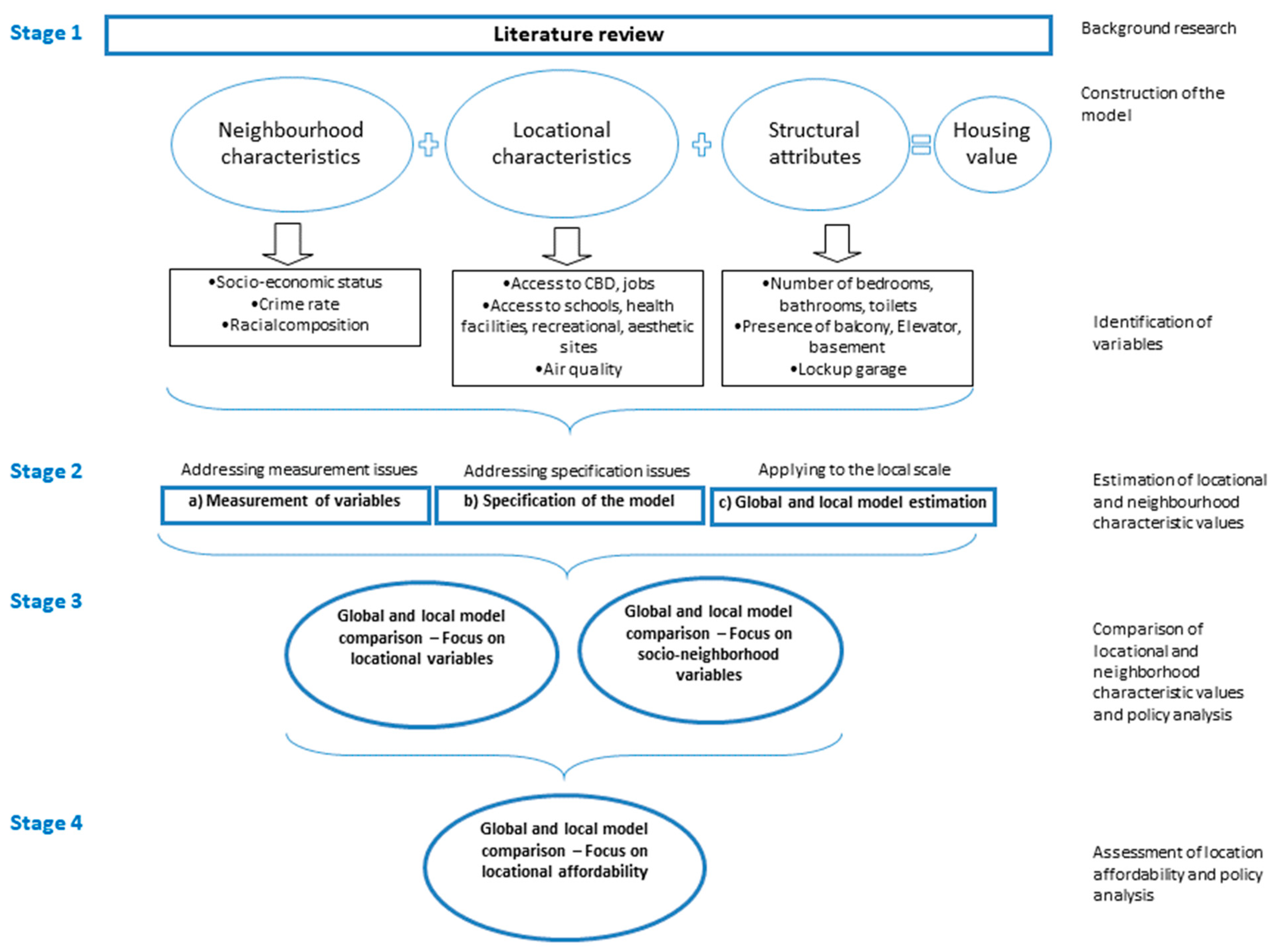
  • Structural characteristics, such as the number (and type) of rooms, floor area, dwelling type, age, heating and cooling provision, and lift access in multistorey buildings;
  • Locational characteristics such as access to educational and health services, recreational facilities and open spaces, and distance from the city center (as a proxy for the amenity bundle in the CBD); and
  • Neighborhood characteristics, such as socioeconomic status, crime rate, and air and noise pollution in the local neighborhood, i.e., suburb, postcode, or based on distance from the house.
Hedonic studies often include a range of locational attributes to assess the effects of these amenities on house prices. Policymakers are aware of locations and the distribution of amenities in a city; however, what essentially matters in terms of resident wellbeing is whether such provision is beneficial to them or ‘generates utility’ in an economic sense. Some amenities may well be located in specific city locations with limited use by residents. The coefficient estimates of the hedonic model reflect these positive and negative effects. In fact, a long tradition of analyzing locational amenity values using the HPM has produced a rich knowledge base. Table 1 summarizes a sample of recent hedonic analyses focusing on specific amenities, the provision of which falls within the remit of the government.

2.2. Amenity Preferences of Residents Inform Urban Planning Policy

Residents’ preferences for amenities are often unrecognized by planners and hence ignored in prioritizing needs. However, scholars argue that prudently implemented evidence-based practice could enrich the field of planning by linking research to practice [27,28]. As discussed in Section 2.1, house price is a summary measure of the desirability of a location based on a bundle of nearby amenities. By addressing the deficits of current methods for assessing urban amenity values (discussed next in Section 3), such models can generate new fine-grained information about the utility of amenities at the local level.
Research on amenity preferences suggests two areas of pertinence to urban planning: enabling evidence-informed planning (‘instrumental view’) [29] and enriching the knowledge environment (‘enlightenment view’) [30].
Evidence-informed planning gains direct knowledge from research and analysis of where different interventions are likely to be socially and economically effective. In a planning context, the values ascribed to amenities change over time; hence, monitoring the benefits becomes paramount in preserving the locational value. Three primary outcomes using the improved tools derived from evidence-informed planning include precise identification of local areas well served by valuable amenities, identification of areas with poor amenities, and assessment of the values of specific infrastructure projects. A promising application to infrastructure is in the field of infrastructure funding and value capture. The appropriate use of evidence-informed policy at the research and planning interface can have far-reaching positive wellbeing outcomes for urban residents as cities develop within a system of ongoing development processes. The experiential tools presented here are particularly useful in a contemporary policy environment that favors evidence-based planning [30] and quantitative evaluation methods [31].
The enlightenment view specifies that the development of accurate new data enriches the knowledge environment within which planners make decisions. If the planning environment is such that planners are not often influenced by new data but mainly by political and financial considerations [32], the proposed framework could still contribute meaningfully by enlightening the planning environment. This viewpoint emphasizes the need for developing a knowledge base of planning case studies and examples that provides a deeper understanding of the conditions within which different interventions might be useful. The positioning of research in this way improves the capacity to make use of the available evidence. Such a knowledge base also enables a greater awareness amongst the various stakeholders, including bureaucrats, planners, and the public. It informs broader public debate, promoting an ‘enlightened society’ as a way of engaging the public in the planning process. Planners can exploit this knowledge to prioritize and communicate planning needs in localities and to negotiate consensus around their planning goals.
As a revealed preference method, the HPM has some traits that make it appropriate in the quest for understanding amenity values based on both the ‘evidence-based planning’ and ‘enlightenment’ viewpoints [33]. Originally, the revealed preference theory was motivated by the unobservability of preferences [34]. For instance, in the alternative ‘stated preference’ methods, the respondents may state their intentions about the worth of some amenity. However, these are not the behaviors that are observed (or revealed) in actual markets. This perceived divergence from market prices, known as ‘hypothetical bias,’ is a result of the imaginary nature of stated preference experiments that do not entail the respondents actually making the choices or executing the behaviors they state [35]. Often the respondents are unable to predict their own actual market behavior accurately in a hypothetical environment.
In contrast, the HPM generates more realistic resident preferences. The HPM estimates the values of housing attributes, including location, using actual house prices in different locations. In an urban planning context, the price premiums paid by residents of an area themselves reveal the attractiveness of localities. One could thus view the HPM as an innovative planning technology in the context of urban policymaking where stakeholder engagement is indirectly incorporated. The application of a relatively objective empirical method also makes the policymaking process more transparent.
Though standalone hedonic studies (see examples in Table 1) may be robust in their own right, they do not provide a reliable and consistent basis for understanding the values of locational amenities more broadly in an applied planning context. These inconsistencies are primarily due to three main limitations in hedonic modeling: measurement, specification, and scale issues.

3. Developing a Coherent Analytical Framework

Despite the potential contribution of the hedonic theory in a planning context, existing modeling instruments investigating amenity values have three main limitations. This section discusses the specifics of these limitations and develops a coherent analytical framework incorporating several essential improvements.

3.1. Addressing Measurement Issues

The first limitation refers to the measurement issues in identifying and accurately calculating locational variables. We highlight two specific respects in which the conventional assumptions of the HPM are arguably flawed.
The first assumption is that a distance threshold of 400 m (known as ‘Ped-Shed’) is appropriate for measuring the effects of proximity to transport nodes on house prices [36,37,38]. This assumption rests on the assertion that 400 m ‘represent a comfortable walk for most people under normal conditions’ [39] (p. 322). A notable concern here is that it takes no account of local geography. Thus, in areas lacking pavements or with steep gradients, people are unlikely to walk as much as where paths are more ‘walkable.’ This practicality means that conventional HPM applications are likely to produce misleading findings. For instance, Herath [40] compared 100 m, 200 m, and 400 m distance thresholds from bus stops in a study of Sydney with contrasting results. The proposed framework systematically tests this particularly problematic assumption of the 400 m distance threshold commonly used to measure the effect of proximity to transport nodes.
The second questionable assumption is that a variable measuring ‘straight-line’ distance can capture the house price effects of distance from an amenity. For instance, house price models employing variables measuring the distance from the CBD generally assume straight-line distance. However, scholarly research conceptualizes distances between different points in space in three different ways [41,42,43,44]. First, straight-line distance computes distance ‘as the crow flies,’ and disregards the actual road network in a city. Second, travel distance, also termed ‘road-network distance,’ measures the distance between two locations along the actual road network, generally considering the shortest path among available routes. Third, overland distance reflects travel times or travel costs, yet again allowing for the fastest or lowest-cost path between two points. Unless the model incorporates the most representative and context-specific distance variable amongst these alternatives, this variable may be statistically insignificant in the model, or the model may lack explanatory power.

3.2. Addressing Specification Issues

The second limitation is the assumption that a variable measuring linear distance from the CBD can explain the structure of a city. Hedonic analyses regularly assume that linear distance adequately captures the CBD’s influence on house prices [45], although an alternative functional form suggests a quadratic function, which translates as an inverted U-shaped curve [46]. The latter reflects an understanding that residents may want to reside neither too close to the city center, because of negative externalities such as air pollution and crime, nor too distant from it, as jobs are concentrated in the CBD. Therefore, empirical assessments need to consider variants of the polynomial distance function, namely, linear, quadratic, and cubic functions.

3.3. Applying to the Local Scale

The third key limitation discussed in this study is the recent proposition that modeling house prices using ‘local’ regression methods is beneficial [47]. The ‘global’ model [48] that focuses on modeling spatial dependence1 in the data is dominant within the empirical literature2. Yet, the local model [49] that incorporates spatial heterogeneit3 is attracting increasing interest [47,50]. The former derives inferences based on the entire data sample (i.e., aggregate study area), although the latter focuses on local data subsamples, uncovering spatial relationships usually hidden in global models. If the global model produces a significant effect for a characteristic, does that hold across all the local areas? Not necessarily. Some local areas may exhibit a positive and significant effect, some a negative and significant effect, and others an insignificant effect. Conversely, an insignificant effect for a characteristic from a global model might also not hold across all local areas—some areas might have a positive and significant effect, some might have a negative and significant effect, while others might have an insignificant effect. In other words, the common use of global regression models is problematic because they omit hidden yet important local dynamics; local models provide a more pertinent modeling strategy capable of producing useful information about the values of local amenities.
The geographically weighted regression (GWR) is a common technique for estimating the local model. The GWR expands the above hedonic model (1) to a form that allows for local variations in the parameter values, taking into account the coordinates of individual regression points. If the dependent variable has the spatial coordinates ( u i , v i ), we can rewrite the model (1) as the following GWR local model:
P i   ( u i , v i ) = β 0 ( u i , v i ) + k = 1 x β k ( u i ,   v i ) z i k + ε i   i   = 1 ,   ,   n
where
P i ( u i , v i ) is the price of the ith house;
β 0 ( u i , v i ) is the location-specific intercept term parameter;
β k ( u i , v i ) is the location-specific parameter of the kth variable;
x is the number of unknown local parameters to be estimated;
z i k is the kth housing characteristic associated with β k ;
ε i is an independently and identically distributed random error term; and
n is the number of observations.
To analyze spatially varying relationships, the GWR model embodies spatial heterogeneity, presumed to be discontinuous or continuous. Parametric methods often achieve a discontinuous demarcation of local areas with fixed bandwidth, a measure of local scale for each conditional relationship. The use of a fixed bandwidth results in the simpler moving-window regression model: the GWR moves a search window from one observation to the next, identifying all the observations within the window. A cross-validation score, a method of reducing variability within sub-samples of data, determines the window size. For local areas with uneven spacing, an adaptive bandwidth is appropriate [49]. In this case, the bandwidth reflects a fixed local sample density instead of a fixed distance across the entire sample, i.e., ‘an optimal bandwidth in an adaptive form’ [51]. Multiscale GWR [52] relaxes GWR’s assumption of a single bandwidth constant across all conditional relationships in the model. This is a further step towards local models that incorporate local scales and dynamics. Multiscale GWR is demonstrated to be superior to GWR in terms of producing more accurate estimates.
As GWR is a local model, relationships are estimated locally and mapped across space. Before proceeding with mapping, a random distribution of residuals validates the statistical robustness of the analysis. It is only worthwhile mapping the statistically significant variables based on the typical t-value for hypothesis-testing (t > 2). A comparison of the global and local models indicates statistical performance using R2 and Akaike’s information criterion (AIC) values4.
The flaws of the house price models mentioned above—measurement, specification, and scale issues—problematically skew our understanding of the urban structure and spatial distribution of amenities [53]. Therefore, these analyses may result in misinformed policy interventions and poor amenity planning decisions [31].

3.4. A Coherent Analytical Framework

The improved conceptual design presented in Figure 1 sets out a coherent analytical framework. The first step is to identify the potential variables, i.e., housing values (proxied by prices or rents) and housing characteristics (see Stage 1). The incorporation of structural variables such as the number of bedrooms and dwelling type into the model specification is relatively straightforward. Thereupon, based on the addresses of houses, their exact locations in longitude and latitude (x, y) coordinates are generated using geographic information software (GIS) (e.g., ArcGIS). These enable the calculation of location variables in relation to various amenities in the city.
Notably, the proposed framework facilitates the identification of context-relevant location variables, computed in the right measurement scales (Stage 2, a). It lays out the need to simultaneously test and compare different model specifications to represent the relationships accurately (Stage 2, b). Model diagnostics such as the statistical significance of the variables and goodness of fit statistics (i.e., the overall performance of the models) assist in choosing the most relevant variables. For the selection problem of locational variables related to distance measurement (e.g., proximity to transport nodes, distance to amenity), the simultaneous consideration of different candidate variables is required. If different ordered tests result in divergent model specifications, the attributes of local geography based on ground-truthing provide clues on context-relevant variables. The proposed procedures improve the reliability and performance of the house price model in a preliminary step by comparing the implications of different location variables on findings. As such, this analytical framework overcomes the shortcomings discussed in Section 3.1 and Section 3.2 above by empirically testing and appropriately adjusting the traditional assumptions related to the distance measurement of the locational variables.
As discussed in Section 3.3, the framework also integrates house prices in a parallel local regression model, i.e., estimated for local subsamples of data, as a more reliable method to capture specific values of local amenities (Stage 2, c). This improvement is critical given the models need to be consistent and appropriate for analyzing the local context from a planning perspective. In addition, the two types of models implemented (i.e., global and local) provide a sound framework for scrutinizing amenity values at both the aggregate city level (city-wide patterns) and local level (local area trends). By comparing global model and local model estimates side-by-side, interesting patterns at the local scale and characteristics more appropriate at the broader study level would be revealed.
The framework thus helps generate information on a range of planning matters, including investigating the values of particular locational amenities and socio-neighborhood characteristics (Stage 3). Since these models incorporate spatial fixed effect variables, such as districts, suburbs, or postcodes, they also indicate the relative values of localities determined by specific amenity values. This new knowledge provides the possibility to detect desirable residential locations and low-value localities in different parts of a city (Stage 4). Based on the findings, governments may direct residential developments into locations with valuables bundles of amenities, or, if city density is becoming unmanageable, preserve these areas from over-development through zoning, council rates, or other means. Overall, this framework represents a comprehensive and innovative approach that challenges the traditional assumptions of house price models, applies variants of the model to understand city-wide and local housing market dynamics, and has the potential to empirically generate policy-significant information regarding the values of locational and neighborhood amenities in cities.

4. Conclusions and Policy Implications

Scholarly work over the last few decades has scrutinized the non-market monetary values of urban amenities using the hedonic price method (HPM), including research with significant planning implications. However, this research falls short of establishing the theoretical interconnections between house prices, the amenity preferences of residents, and urban planning. In this article, we put forward a framework termed a consumer preference-based approach to urban amenity provision to map out how hedonic prices reveal the values that residents ascribe to nearby amenities and how planners could incorporate this information into their decision-making. This new framework is based on a house price model typically used to explain the demand for, and the prices of, housing, and hence generates incremental and transformative gains in the urban economics and urban planning disciplines. The improvements in potential reliability of the model lead to incremental gains within urban economics, and the application of a new and consistent hedonic approach for local amenity planning results in transformative gains in the urban planning discipline.
As a revealed preference method, the HPM at first glance appears to be an appropriate methodology to assess amenity values. However, several concerns need resolving to utilize these applications appropriately in a planning context: (1) measurement issues associated with identifying and accurately calculating locational variables, (2) model misspecification issues, and (3) the problematic common use of global regression models. A robust, integrated, transparent, and systematic analytical framework is needed to empirically test a range of model assumptions and eventually improve the precision of the model.
This article aimed to advance existing approaches to understanding the value of urban locations by focusing attention on amenities, particularly as they affect residential land values at the local level. The proposed conceptual framework integrates hedonic price theory and cutting-edge econometric tools but applies these as planning tools, demonstrating improved analytical models to reliably identify the values of high-demand amenities in cities. Despite the long-standing practice of explaining local spatial disparities in the housing markets based on global hedonic models, the framework further evaluates the usefulness of local regression methods that are intuitively preferred when location-specific information is required for housing and urban planning purposes. These improvements are innovative in their ability to address deficits in current methods of assessing urban amenity values and generate new local fine-grained information about the utility of such amenities.
This is the first paper to explicitly demonstrate the contribution of the separate theoretical field of urban economics to the planning literature and to lay out the conceptual alignment between house prices, amenity preferences, and amenity provision (Section 2). It also recognizes the important deficits that exist in the conventional hedonic applications and specific improvements within an integrated framework (Section 3). Future research will focus on an extended piece of work testing this framework using a case study, including tests of different measurements and specifications, location and neighborhood characteristics, and local and global model estimates.
In policy terms, the framework develops and tests an objective and data-driven mechanism that assesses spatial equality in terms of urban amenities in smaller localities such as suburbs. The creation of more accurate and dynamic data-driven prototypes could inform a broad range of spatial planning and policy interventions to help governments address the following key questions:
  • In which areas should housing be provided (or zoned)? The proposed suite of models can benchmark local area amenity availability against city-wide amenities. The improved models could, therefore, facilitate precise identification of localities well served by valuable amenities, with capacity and potential for increased housing. These more reliable measurements of valuable amenities may indicate possible directions of urban growth processes, enable more efficient use of existing urban amenities, encourage development within existing urbanized areas, and minimize the environmental impact of residential development.
  • In which areas should urban amenities be provided? Again, this proposed framework could help identify low-value localities with poor amenities. The operation of the housing market in major cities embeds inequality, and there seems little interest in addressing these disparities. While some inequality is inherent in amenity provision, the integrated tools proposed here could reliably identify where investment in amenities would pay off best, an essential element when the value for money is a paramount concern. This new knowledge may facilitate the distribution of public funds and target investment to improve amenities in areas identified as optimal from an amenities point of view, improving residents’ wellbeing and enhancing spatial connectivity. Identifying localities that lack amenities may also provide a substantial incentive to the private sector to invest in transit-oriented development. As such, the proposed tools offer another source of value, providing at least the potential of an additional means of reducing urban inequality. It is also important to note that improving the most vulnerable areas may have a negligible effect on house prices at the aggregate city level.
  • What is a community’s willingness to pay for specific infrastructure assets? The improved models may assist in evaluating these assets and developing value capture mechanisms through rates, levies, charges, or other means. They can explain the effects of specific infrastructure on nearby property values and help assess associated urban productivity outcomes related to amenity projects and value creation opportunities.
  • What are the effects of adverse environmental characteristics? The suite of proposed models could detect low-value undesirable localities with dis-amenities requiring intervention.
From a planning practice perspective, elements within this analytical framework could be translated into a useful toolkit for urban planners to assist and inform urban planning decision-making. An important area of application is in the provision of urban parks. Production costs of urban parks are often known and easily measurable (costs of planting trees, hedge cuts, etc.), but benefits are more difficult to assess. These models evaluate the benefits of protecting existing urban green areas and providing new urban parks within the planning processes to facilitate long-term urban development strategies. For instance, a local council may assess how the benefits could change with different configurations of park sizes. Mahmoudi et al. [54] estimated that an expansion of a pocket park from 0.4 ha to 1 ha resulted in $0.9 M in private benefits being capitalized in property values. These values are useful in cost-benefit analyses to determine the types of urban parks that are likely to yield benefits. City planners could preserve or enhance housing values by considering the spatial configuration and species composition of open space in residential neighborhoods [55]. By identifying forest land values of planned areas with consistently high visual amenity values, planners could generate the highest potential return on investment for preservation and reforestation [56]. In addition, the capitalized property values associated with key environmental amenities could measure the contribution of local amenities to land tax [57].
The improved models would address a critical gap in the planning practice and policy domains, introducing demand-side analytical tools to uncover local area demand determinants. The information and maps generated could indicate the values of amenities in localities, a piece of information vital for facilitating a more efficient distribution of housing and amenities in cities. Hence, the proposed analytical framework could have a significant and immediate policy and practice implications for creating and preserving a city that is both equitable and sustainable. It is worth noting, however, that social wellbeing motives alone do not determine amenity provision, and economic (e.g., provision of amenities to attract businesses and promote tourism) and political reasons may influence amenity provision to some extent.
Finally, this article contributes to an important area of research in the evaluation of amenities and services in urban localities. While addressing a significant theoretical and empirical gap in the planning literature, the proposed framework provides a potentially robust methodological integration to deal with the shortcomings of present evaluation methods. The framework could inform planning policy by improving the capacity to identify localities well served with amenities and vice versa, thus providing a basis for policy action to enhance spatial equality in cities. The empirical tools presented are particularly suited to a policy environment that aligns with the new trend towards evidence-based planning and quantitative evaluation methods. Due to its data-driven nature, the proposed framework supports an objective assessment that can enhance economic efficiency, productivity, and spatial equity within cities. To that end, the proposed framework seeks greater policy relevance by positioning the measurements in local planning realities.

Funding

This research received no external funding.

Institutional Review Board Statement

Not applicable.

Informed Consent Statement

Not applicable.

Data Availability Statement

Not applicable.

Conflicts of Interest

The author declares no conflict of interest.

Notes

1
Spatial dependence is the interdependence of variable values—either prices, housing features or both—among nearby locations.
2
The Equation (1) above estimated for the entire study sample is a ‘global model’.
3
This refers to an uneven distribution of variable values within an area that originates from characteristics of demand, supply or institutional barriers.
4
Akaike’s information criterion (AIC) is a measure of model fit (a lower value indicating a better model fit).

References

  1. United Nations. World Urbanization Prospects: The 2018 Revision (St/Esa/Ser. A/420); United Nations: New York, NY, USA, 2019. [Google Scholar]
  2. Rigolon, A. A Complex Landscape of Inequity in Access to Urban Parks: A Literature Review. Landsc. Urban Plan. 2016, 58, 160–169. [Google Scholar] [CrossRef]
  3. Payton, S.B.; Ottensmann, J.R. The Implicit Price of Urban Public Parks and Greenways: A Spatial-Contextual Approach. J. Environ. Plan. Manag. 2015, 58, 495–512. [Google Scholar] [CrossRef] [Green Version]
  4. Myers, D. Building Knowledge About Quality of Life for Urban Planning. J. Am. Plan. Assoc. 1988, 54, 347–358. [Google Scholar] [CrossRef]
  5. Turnbull, G.K.; Zahirovic-Herbert, V.; Zheng, M. Uncertain School Quality and House Prices: Theory and Empirical Evidence. J. Real Estate Financ. Econ. 2017, 57, 167–191. [Google Scholar] [CrossRef]
  6. Mccord, J.; Mccord, M.; McCluskey, W.; Davis, P.; McIlhatton, D.; Haran, M. Effect of public green space on residential property values in Belfast metropolitan area. J. Financ. Manag. Prop. Constr. 2014, 19, 117–137. [Google Scholar] [CrossRef]
  7. Higgins, C.; Kanaroglou, P. Rapid transit, transit-oriented development, and the contextual sensitivity of land value uplift in Toronto. Urban Stud. 2017, 55, 2197–2225. [Google Scholar] [CrossRef] [Green Version]
  8. Baranzini, A.; Schaerer, C. A Sight for Sore Eyes: Assessing the Value of View and Land Use in the Housing Market. J. Hous. Econ. 2011, 20, 191–199. [Google Scholar] [CrossRef] [Green Version]
  9. Zheng, S.; Cao, J.; Kahn, M.E.; Sun, C. Real Estate Valuation and Cross-Boundary Air Pollution Externalities: Evidence from Chinese Cities. J. Real Estate Financ. Econ. 2013, 48, 398–414. [Google Scholar] [CrossRef]
  10. Buonanno, P.; Montolio, D.; Raya-Vílchez, J.M. Housing prices and crime perception. Empir. Econ. 2012, 45, 305–321. [Google Scholar] [CrossRef]
  11. Herath, S.; Gunther, M. Local Particularities or Distance Gradient. J. Eur. Real Estate Res. 2013, 6, 163–185. [Google Scholar] [CrossRef]
  12. Mayor, K.; Lyons, S.; Duffy, D.; Tol, R.S. A Hedonic Analysis of the Value of Rail Transport in the Greater Dublin Area. J. Transp. Econ. Policy 2012, 46, 239–261. [Google Scholar]
  13. Rosen, S. Hedonic Prices and Implicit Markets: Product Differentiation in Pure Competition. J. Political Econ. 1974, 82, 34–55. [Google Scholar] [CrossRef]
  14. Gross, D.J. Estimating willingness to pay for housing characteristics: An application of the Ellickson bid-rent model. J. Urban Econ. 1988, 24, 95–112. [Google Scholar] [CrossRef]
  15. Malpezzi, S. Hedonic Pricing Models: A Selective and Applied Review. In Housing Economics and Public Policy; O’Sullivan, T., Gibb, K., Eds.; Blackwell Science: Malden, MA, USA, 2003; pp. 67–89. [Google Scholar]
  16. Sheppard, S. Hedonic Analysis of Housing Markets. In Handbook of Regional and Urban Economics; Chesire, P.C., Mills, E.S., Eds.; Elsevier: Amsterdam, The Netherlands, 1999. [Google Scholar]
  17. Follain, J.R.; Jimenez, E. Estimating the demand for housing characteristics: A survey and critique. Reg. Sci. Urban Econ. 1985, 15, 77–107. [Google Scholar] [CrossRef]
  18. Mulley, C. Accessibility and Residential Land Value Uplift: Identifying Spatial Variations in the Accessibility Impacts of a Bus Transitway. Urban Stud. 2013, 51, 1707–1724. [Google Scholar] [CrossRef]
  19. Wang, Y.; Potoglou, D.; Orford, S.; Gong, Y. Bus Stop, Property Price and Land Value Tax: A Multilevel Hedonic Analysis with Quantile Calibration. Land Use Policy 2015, 42, 381–391. [Google Scholar] [CrossRef] [Green Version]
  20. Wang, Y.; Feng, S.; Deng, Z.; Cheng, S.; Feng, S. Transit premium and rent segmentation: A spatial quantile hedonic analysis of Shanghai Metro. Transp. Policy 2016, 51, 61–69. [Google Scholar] [CrossRef] [Green Version]
  21. Herath, S.; Choumert, J.; Maier, G. The value of the greenbelt in Vienna: A spatial hedonic analysis. Ann. Reg. Sci. 2015, 54, 349–374. [Google Scholar] [CrossRef] [Green Version]
  22. Franco, S.F.; Macdonald, J.L. Measurement and Valuation of Urban Greenness: Remote Sensing and Hedonic Applications to Lisbon, Portugal. Reg. Sci. Urban Econ. 2018, 72, 156–180. [Google Scholar] [CrossRef]
  23. Belcher, R.N.; Chisholm, R.A. Tropical Vegetation and Residential Property Value: A Hedonic Pricing Analysis in Singapore. Ecol. Econ. 2018, 149, 149–159. [Google Scholar] [CrossRef]
  24. Chung, I.H. School Choice, Housing Prices, and Residential Sorting: Empirical Evidence from Inter-and Intra-District Choice. Reg. Sci. Urban Econ. 2015, 52, 39–49. [Google Scholar] [CrossRef]
  25. Sah, V.; Conroy, S.J.; Narwold, A. Estimating School Proximity Effects on Housing Prices: The Importance of Robust Spatial Controls in Hedonic Estimations. J. Real Estate Financ. Econ. 2016, 53, 50–76. [Google Scholar] [CrossRef]
  26. Wen, H.; Xiao, Y.; Zhang, L. School district, education quality, and housing price: Evidence from a natural experiment in Hangzhou, China. Cities 2017, 66, 72–80. [Google Scholar] [CrossRef]
  27. Krizek, K.; Forysth, A.; Slotterback, C.S. Is There a Role for Evidence-Based Practice in Urban Planning and Policy? Plan. Theory Pract. 2009, 10, 459–478. [Google Scholar] [CrossRef]
  28. Faludi, A.; Waterhout, B. Introducing Evidence-Based Planning. DisP-Plan. Rev. 2006, 42, 4–13. [Google Scholar] [CrossRef]
  29. Higgins, K.; Canavan, J.; Coen, L. Mapping the field in evidence-informed policy and practice: International perspectives. EÉvid. Policy J. Res. Debate Pract. 2014, 10, 489–495. [Google Scholar] [CrossRef]
  30. Davoudi, S. Evidence-Based Planning. DisP-Plan. Rev. 2006, 42, 14–24. [Google Scholar] [CrossRef]
  31. Herath, S. Technology in Urban Planning: Spatial Hedonic House Price Model as an Information Tool. In Instruments of Planning: Tensions and Challenges for More Equitable and Sustainable Cities; Leshinsky, R., Legacy, C., Eds.; Routledge: London, UK, 2016; pp. 228–240. [Google Scholar]
  32. Adjei-Poku, B. Rationality and Power in Land Use Planning: A Conceptual View of the Relationship. J. Plan. Lit. 2018, 33, 45–60. [Google Scholar] [CrossRef]
  33. Caplin, A.; Dean, M. Revealed Preference, Rational Inattention, and Costly Information Acquisition. Am. Econ. Rev. 2015, 105, 2183–2203. [Google Scholar] [CrossRef] [Green Version]
  34. Samuelson, P.A. A Note on the Pure Theory of Consumer’s Behaviour. Economica 1938, 5, 61–71. [Google Scholar] [CrossRef]
  35. Beck, M.J.; Simon, F.; John, M.R. Can You Ever Be Certain? Reducing Hypothetical Bias in Stated Choice Experiments Via Respondent Reported Choice Certainty. Transp. Res. Part B Methodol. 2016, 89, 149–167. [Google Scholar] [CrossRef]
  36. Ibeas, Á.; Cordera, R.; dell’Olio, L.; Coppola, P.; Dominguez, A. Modelling Transport and Real-Estate Values Interactions in Urban Systems. J. Transp. Geogr. 2012, 24, 370–382. [Google Scholar] [CrossRef] [Green Version]
  37. Munoz-Raskin, R. Walking Accessibility to Bus Rapid Transit: Does It Affect Property Values? The Case of Bogotá, Colombia. Transp. Policy 2010, 17, 72–84. [Google Scholar] [CrossRef]
  38. Alan, T.M. Strategic Analysis of Public Transport Coverage. Socio-Econ. Plan. Sci. 2001, 35, 175–188. [Google Scholar]
  39. Murray, A.T.; Davis, R.; Stimson, R.J.; Ferreira, L. Public Transportation Access. Transp. Res. Part D Transp. Environ. 1998, 3, 319–328. [Google Scholar] [CrossRef] [Green Version]
  40. Herath, S. How Far Is Too Far from Public Transport? An Empirical Assessment. In Proceedings of the RICS COBRA AUBEA 2015, Sydney, Australia, 8–10 July 2015. [Google Scholar]
  41. Nilsson, P. The Influence of Urban and Natural Amenities on Second Home Prices. J. Hous. Built Environ. 2014, 30, 427–450. [Google Scholar] [CrossRef]
  42. Karlsson, V. The Relationship of Housing Prices and Transportation Improvements: Location and Marginal Impact. Spat. Econ. Anal. 2011, 6, 223–241. [Google Scholar] [CrossRef]
  43. A Sander, H.; Ghosh, D.; van Riper, D.; Manson, S.M. How Do You Measure Distance in Spatial Models? An Example Using Open-Space Valuation. Environ. Plan. B Plan. Des. 2010, 37, 874–894. [Google Scholar] [CrossRef]
  44. Herath, S.; Jayasekare, A.S. City proximity, travel modes and house prices: The three cities in Sydney. Neth. J. Hous. Environ. Res. 2021, 36, 407–431. [Google Scholar] [CrossRef]
  45. Osland, L.; Pryce, G. Housing Prices and Multiple Employment Nodes: Is the Relationship Nonmonotonic? Hous. Stud. 2012, 27, 1182–1208. [Google Scholar] [CrossRef] [Green Version]
  46. Lu, B.; Charlton, M.; Harris, P.; Fotheringham, A.S. Geographically weighted regression with a non-Euclidean distance metric: A case study using hedonic house price data. Int. J. Geogr. Inf. Sci. 2013, 28, 660–681. [Google Scholar] [CrossRef]
  47. Crespo, R.; Grêt-Regamey, A. Local Hedonic House-Price Modelling for Urban Planners: Advantages of Using Local Regression Techniques. Environ. Plan. B Plan. Des. 2013, 40, 664–682. [Google Scholar] [CrossRef]
  48. Anselin, L. Spatial Econometrics: Methods and Models; Kluwer: Dordrecht, The Netherlands, 1988. [Google Scholar]
  49. Fotheringham, A.S.; Brunsdon, C.; Charlton, M. Geographically Weighted Regression: The Analysis of Spatiality Varying Relationships; John Wiley: Chichester, UK, 2002. [Google Scholar]
  50. Tsai, C.-H.; Mulley, C.; Burke, M.; Yen, B. Exploring property value effects of ferry terminals: Evidence from Brisbane, Australia. J. Transp. Land Use 2015, 10, 119–137. [Google Scholar] [CrossRef] [Green Version]
  51. Harris, P.; Fotheringham, A.S.; Crespo, R.; Charlton, M. The Use of Geographically Weighted Regression for Spatial Prediction: An Evaluation of Models Using Simulated Data Sets. Math. Geol. 2010, 42, 657–680. [Google Scholar] [CrossRef]
  52. Fotheringham, A.S.; Yang, W.; Kang, W. Multiscale Geographically Weighted Regression (Mgwr). Ann. Am. Assoc. Geogr. 2017, 107, 1247–1265. [Google Scholar] [CrossRef]
  53. Dziauddin, M.F.; Powe, N.; Alvanides, S. Estimating the Effects of Light Rail Transit (LRT) System on Residential Property Values Using Geographically Weighted Regression (GWR). Appl. Spat. Anal. Policy 2014, 8, 1–25. [Google Scholar] [CrossRef] [Green Version]
  54. Mahmoudi, P.; MacDonald, D.H.; Crossman, N.D.; Summers, D.M.; van der Hoek, J. Space matters: The importance of amenity in planning metropolitan growth. Aust. J. Agric. Resour. Econ. 2012, 57, 38–59. [Google Scholar] [CrossRef] [Green Version]
  55. Cho, S.H.; Poudyal, N.C.; Roberts, R.K. Spatial Analysis of the Amenity Value of Green Open Space. Ecol. Econ. 2008, 66, 403–416. [Google Scholar] [CrossRef]
  56. Chadourne, M.; Cho, S.H.; Roberts, R.K. Identifying priority target areas for the Knoxville-Knox County hillside and ridgetop protection plan: Using the value of visual amenity during the real estate boom of 2002-2007 and the recession of 2008. Ann. Reg. Sci. 2013, 50, 911–934. [Google Scholar] [CrossRef] [Green Version]
  57. Gibbons, S.; Mourato, S.; Resende, G.M. The Amenity Value of English Nature: A Hedonic Price Approach. Environ. Resour. Econ. 2013, 57, 175–196. [Google Scholar] [CrossRef] [Green Version]
Figure 1. A Coherent Analytical Framework.
Land 10 01226 g001
Table 1. A Sample of Recent Hedonic Analyses on Transport Access, Public Parks, and School Quality.
AmenityStudyCityProperty TypePeriod
Covered
Number of ObservationsSummary Findings
Transport
access
Higgins and
Kanaroglou [7]
Toronto, CanadaSingle-detached
homes
2001–2003,
2010–2014
2000 (sales)Transit-oriented development (TOD) was capitalized into land values, though the maximum amount and spatial impact area of this capitalization differed by the TOD context.
Mulley [18]Sydney, AustraliaResidential housing20061598 (sales)Accessibility by car and accessibility to employment along the transitway partly determined property prices. Accessibility effects varied significantly over the geographical space.
Wang et al. [19]Cardiff, WalesResidential housing2000–200912,887 (sales)The number of bus stops within walking distance (300–1500 m) of property was positively associated with the property’s observed sale price. The properties with higher market prices tended to benefit more from spatial proximity to bus stop locations compared with their low-priced counterparts.
Wang et al. [20]Shanghai, ChinaTwo-bedroom/one-bathroom apartments2012–20132575 (average
asking rents)
A residential complex community’s adjacency to the nearest Shanghai Metro station tended to correlate positively with its average asking rent.
Public parks and green areasMcCord et al. [6]Belfast, IrelandResidential housing20113854 (sales)Urban green spaces had a significant positive impact on nearby residential properties’ sale prices for the terrace and apartment sectors. Terrace and apartment properties located closer to public green spaces achieved increases in their sale price of up to 49 percent compared to otherwise similar properties. Adjacency to green open space produced significant property value premiums in only two of the four housing types analyzed, with limited statistically significant proximate effects evident for the detached and semi-detached sectors.
Herath et al. [21]Vienna, AustriaApartments2009–20101651 (sales)Base Model: the price of constant-quality apartments declined by approximately 0.13–0.26% with every 1% increase in distance from the greenbelt. Spatial Model (SEM): The corresponding decrease in price was 0.13%.
Franco and
Macdonald [22]
Lisbon, PortugalTwo-bedroom
apartments
200711,617 (listing
prices)
Residential apartment prices reflected the effect of proximity to both large urban forests and smaller neighborhood parks. There was a positive value associated with tree canopy coverage, in that a 1 km2 increase in the relative size of tree canopy was valued at 0.20% of dwelling price, or approximately €400 per dwelling.
Belcher and
Chisholm [23]
SingaporePublic housing
apartments
2013–201415,962 (sales)On average, managed, spontaneous, and high conservation value vegetation had positive effects on property selling price, accounting for 3% of the average property’s value, or a total of $179 million Singapore dollars for all public housing apartments sold over 13 months. These effects were almost entirely driven by managed vegetation, which had positive marginal effects on the price for 98.1% of properties.
School qualityTurnbull et al. [5]Orange County,
Florida
Single-family
houses
2001–2012127,120 (sales)House prices reflected the effect of school quality. Increasing the variance in test scores by one standard deviation reduced house prices by 0.7%. The capitalization effects tended to be stronger in higher-income neighborhoods.
Chung [24]Seoul, South KoreaApartments2004–201228,182 (sales),
10,259 (rents)
School choice reform (allowing students to choose high schools outside as well as within their school districts) reduced housing prices in a high-performing school district relative to the housing prices in a low-performing school district by approximately 10–27%.
Sah et al. [25]San Diego County,
California
Residential housing2010–201120,000 (sales)There was a school proximity penalty for public elementary schools. Spatially dividing the sample area into a coastal and an inland region led to a delayed proximity premium for the inland region and a very strong proximity penalty effect for the coastal region.
Wen et al. [26]Hangzhou, ChinaMulti-layer and
high-rise housing
2011–2013660 (average
prices)
Surrounding housing prices reflected the quality of basic education in the neighborhood. Primary and secondary schools had significant school district effects.
Publisher’s Note: MDPI stays neutral with regard to jurisdictional claims in published maps and institutional affiliations.

