
Revealing Characteristics of the Spatial Structure of Megacities at Multiple Scales with Jobs-Housing Big Data: A Case Study of Tianjin, China


Abstract
:1. Introduction
2. Literature Review
2.1. Sustainable Urban Development and Spatial Structure
2.2. Identification and Characteristics of Urban Spatial Structure
3. Materials and Methods
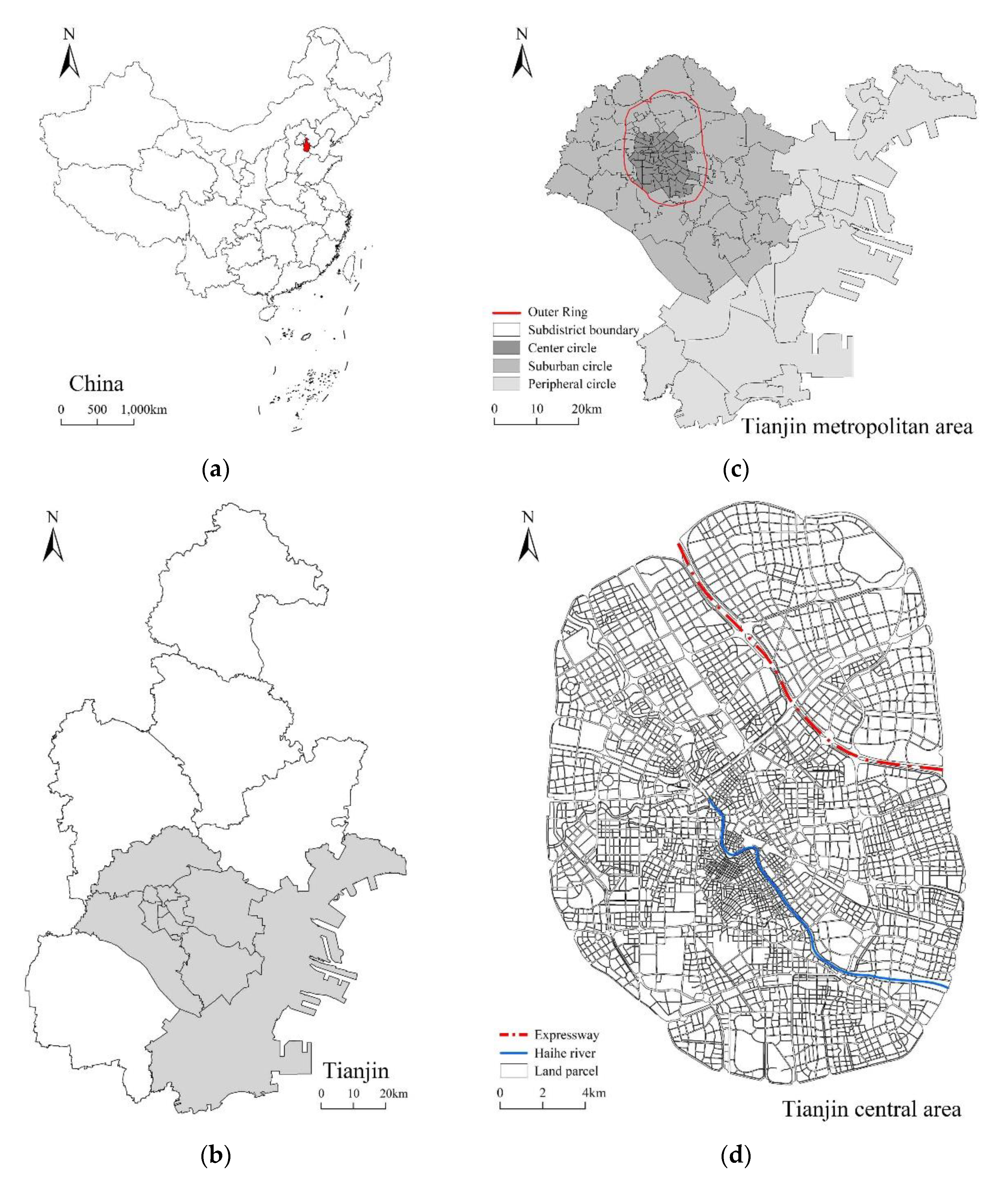
3.1. Study Area
3.2. Data
3.3. Methods
3.3.1. Identification of Static Characteristics
3.3.2. Identification of Dynamic Characteristics
4. Results
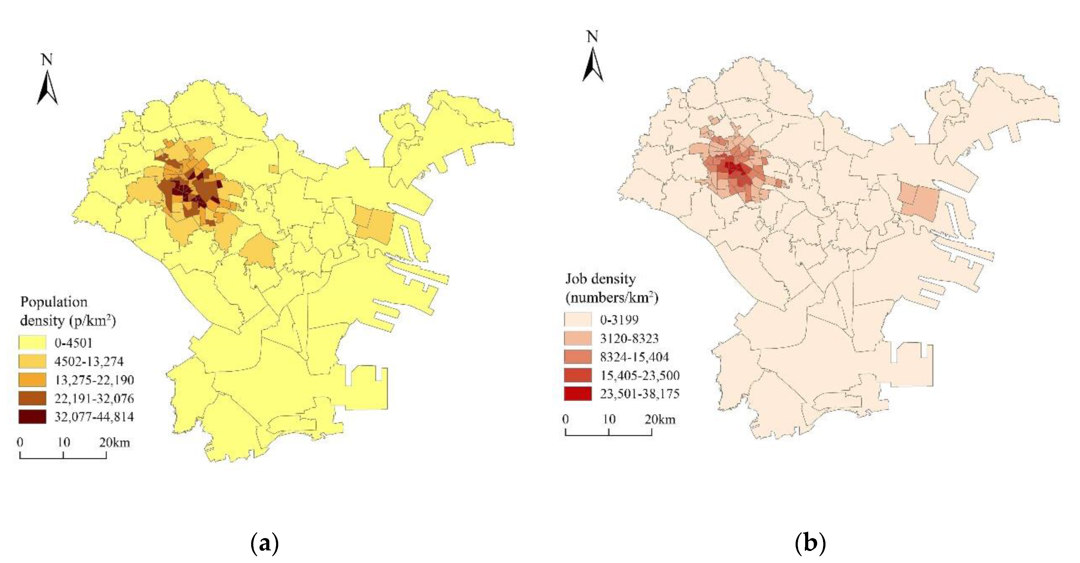
4.1. Static Polycentricity
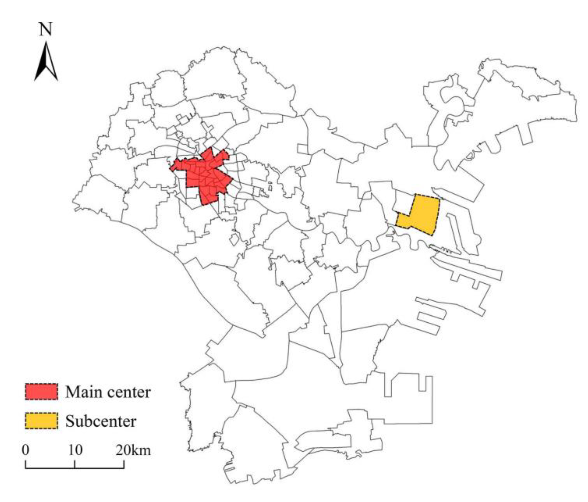
4.1.1. Polycentricity in the Metropolitan Area
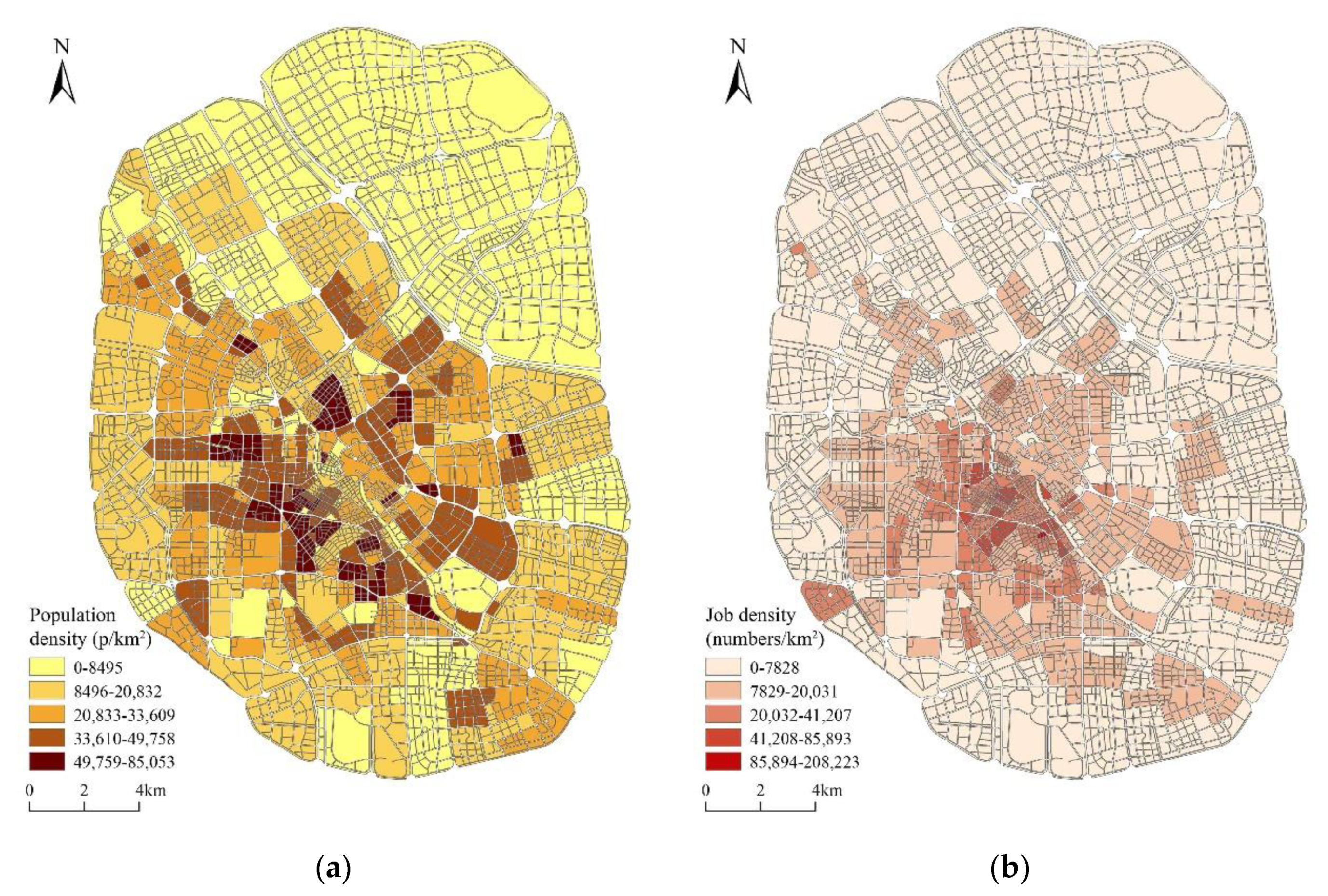
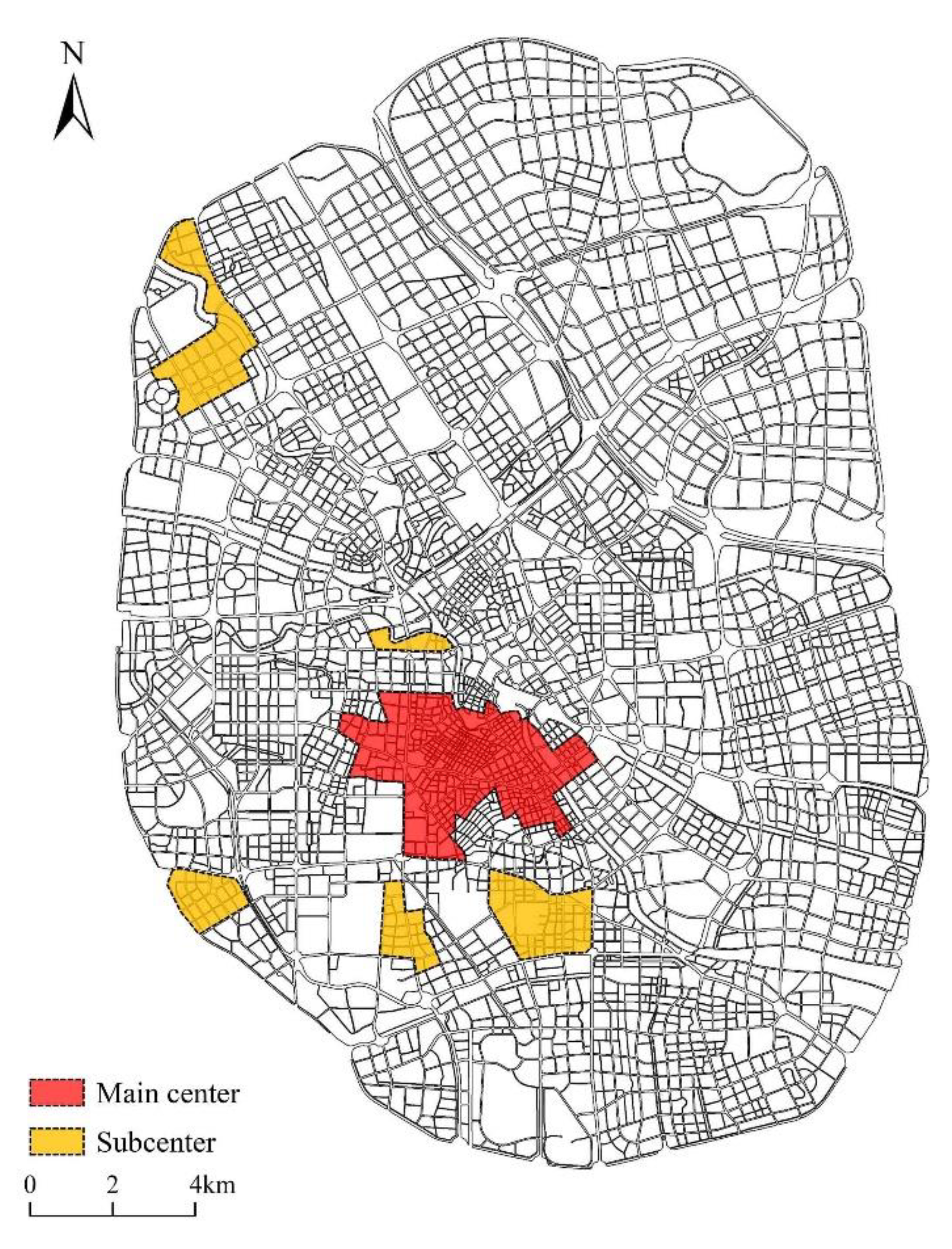
4.1.2. Polycentricity in the Central Area
4.2. Dynamic Commuting Communities
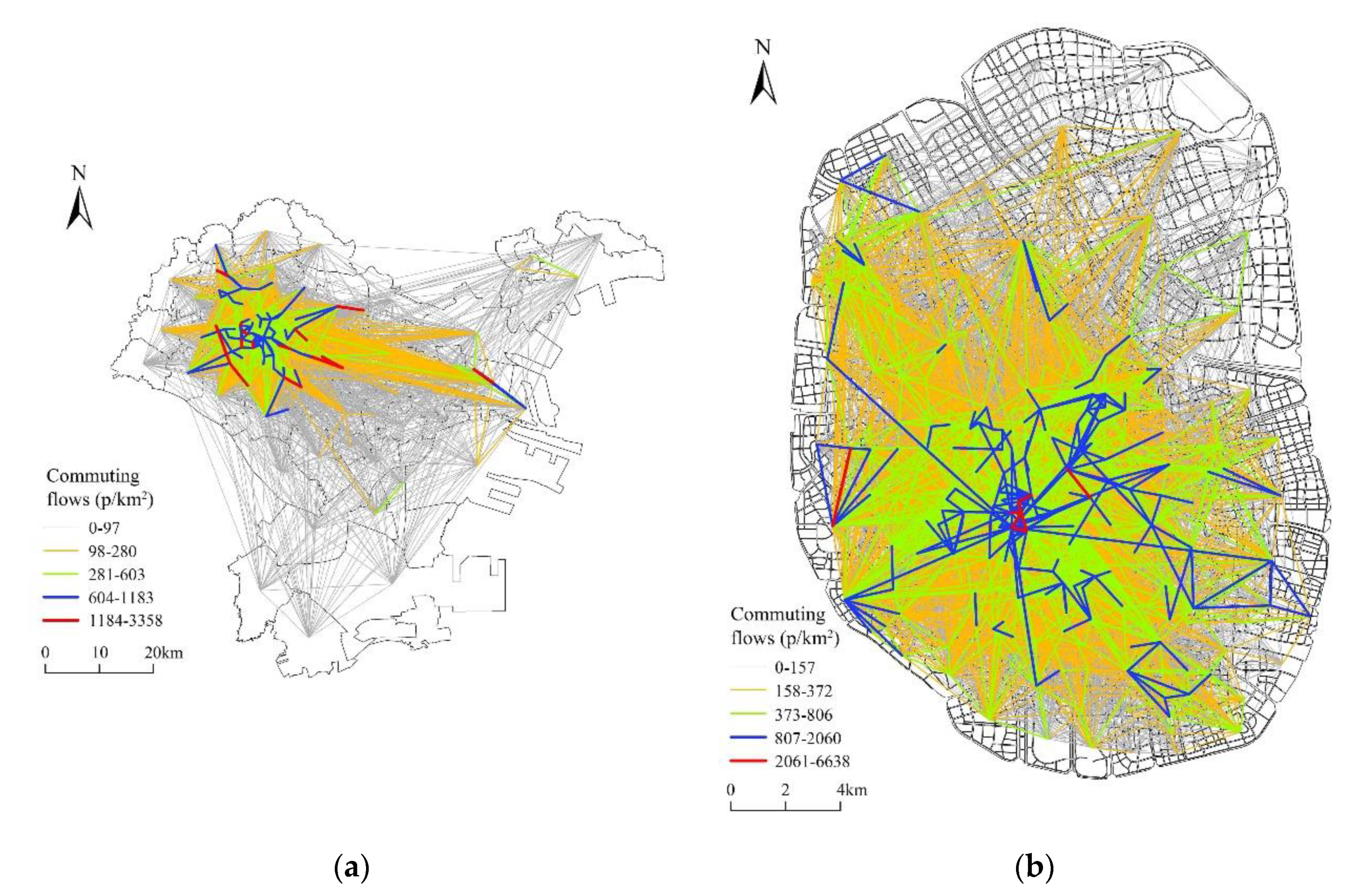
4.2.1. Commuting Communities in the Metropolitan Area
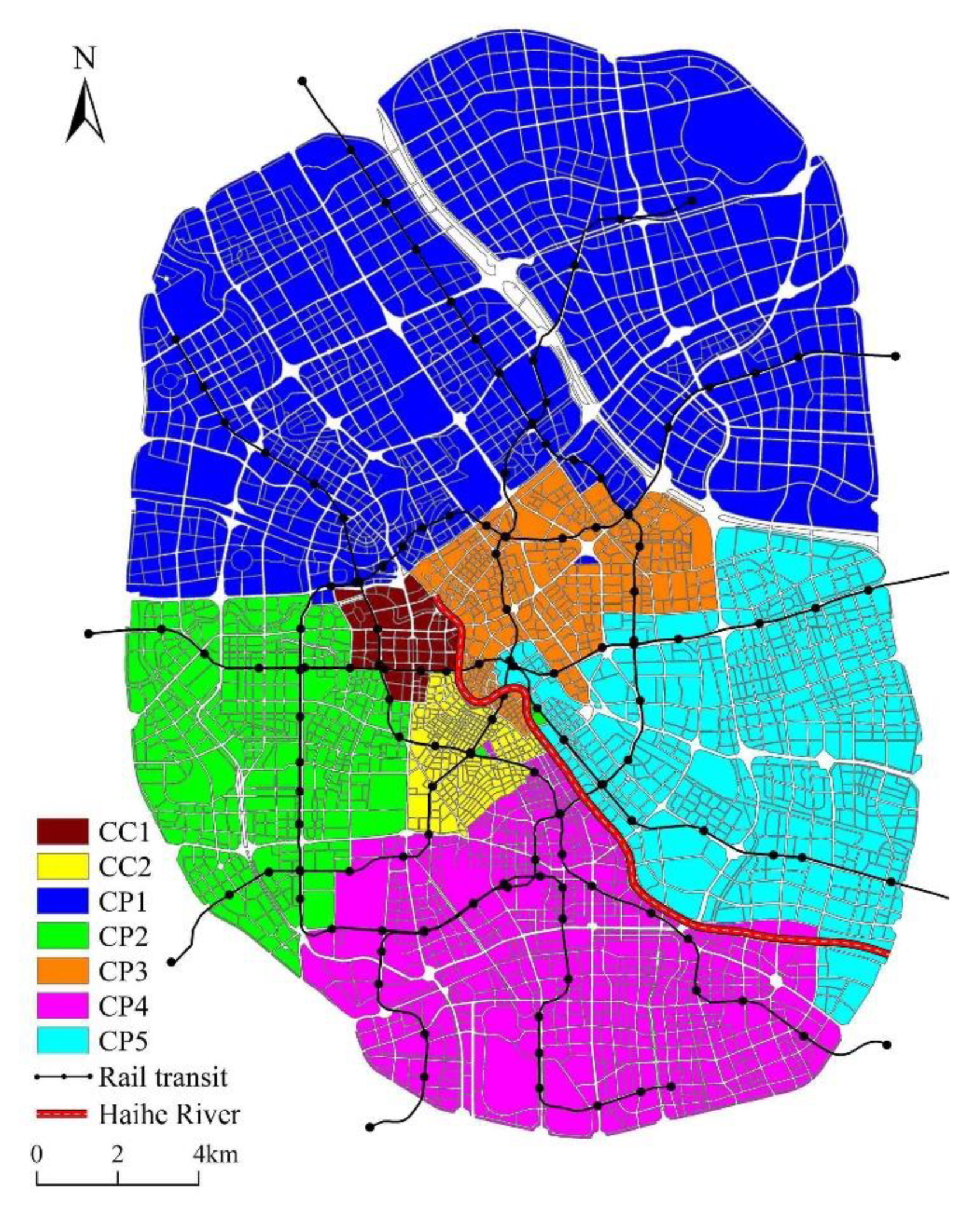
4.2.2. Commuting Communities in the Central Area
5. Discussion
5.1. Does Polycentricity Explain the Distribution of Jobs in Cities?
5.2. Jobs–Housing Balance Levels in Commuting Communities
6. Conclusions
Author Contributions
Funding
Conflicts of Interest
References
- Gordon, P.; Richardson, H.W. Employment Decentralization in US Metropolitan Areas: Is Los Angeles an Outlier or the Norm? Environ. Plan. A Econ. Space 1996, 28, 1727–1743. [Google Scholar] [CrossRef]
- García-Palomares, J.C. Urban sprawl and travel to work: The case of the metropolitan area of Madrid. J. Transp. Geogr. 2010, 18, 197–213. [Google Scholar] [CrossRef]
- Zhao, P. Sustainable urban expansion and transportation in a growing megacity: Consequences of urban sprawl for mobility on the urban fringe of Beijing. Habitat Int. 2010, 34, 236–243. [Google Scholar] [CrossRef]
- Bai, X.; Shi, P.; Liu, Y. Society: Realizing China’s urban dream. Nature 2014, 509, 158–160. [Google Scholar] [CrossRef] [Green Version]
- Li, H.; Chen, K.; Yan, L.; Zhu, Y.; Liao, L.; Chen, Y. Urban Land Use Transitions and the Economic Spatial Spillovers of Central Cities in China’s Urban Agglomerations. Land 2021, 10, 644. [Google Scholar] [CrossRef]
- Huang, D.; Liu, Z.; Zhao, X.; Zhao, P. Emerging polycentric megacity in China: An examination of employment subcenters and their influence on population distribution in Beijing. Cities 2017, 69, 36–45. [Google Scholar] [CrossRef]
- Horner, M.W.; Mefford, J.N. Investigating Urban Spatial Mismatch Using Job–Housing Indicators to Model Home–Work Separation. Environ. Plan. A Econ. Space 2007, 39, 1420–1440. [Google Scholar] [CrossRef]
- Ma, K.-R.; Banister, D. Urban Spatial Change and Excess Commuting. Environ. Plan. A Econ. Space 2007, 39, 630–646. [Google Scholar] [CrossRef]
- Yuan, M.; Yan, M.; Shan, Z. Is Compact Urban Form Good for Air Quality? A Case Study from China Based on Hourly Smartphone Data. Land 2021, 10, 504. [Google Scholar] [CrossRef]
- Zhu, J.; Fan, Y. Commute happiness in Xi’an, China: Effects of commute mode, duration, and frequency. Travel Behav. Soc. 2018, 11, 43–51. [Google Scholar] [CrossRef]
- WECD. Our Common Future. In Brundtland Report; World Commission on Environment and Development; Oxford University Press: Oxford, UK, 1987; pp. 1–300. [Google Scholar]
- Olawumi, T.O.; Chan, D.W. A scientometric review of global research on sustainability and sustainable development. J. Clean. Prod. 2018, 183, 231–250. [Google Scholar] [CrossRef]
- Klopp, J.M.; Petretta, D.L. The urban sustainable development goal: Indicators, complexity and the politics of measuring cities. Cities 2017, 63, 92–97. [Google Scholar] [CrossRef]
- Yang, D.; Mao, Q.; Long, Y. Towards Sustainable Urban Development: From Concepts to Paradigm. Urban Plan. Forum 2010, 1, 49–57. [Google Scholar]
- Blassingame, L. Sustainable cities: Oxymoron, utopia, or inevitability? Soc. Sci. J. 1998, 35, 1–13. [Google Scholar] [CrossRef]
- Yigitcanlar, T.; Teriman, S. Rethinking sustainable urban development: Towards an integrated planning and development process. Int. J. Environ. Sci. Technol. 2014, 12, 341–352. [Google Scholar] [CrossRef] [Green Version]
- Dantzing, G.B.; Thomas, S. Compact City: A Plan for a Livable Urban Environment; W.H. Freeman: San Francisco, CA, USA, 1973. [Google Scholar]
- Kenworthy, J. The eco-city: Ten key transport and planning dimensions for sustainable city development. Environ. Urban 2006, 18, 67–85. [Google Scholar] [CrossRef]
- Feliciano, M.; Prosperi, D.C. Planning for low carbon cities: Reflection on the case of Broward County, Florida, USA. Cities 2011, 28, 505–516. [Google Scholar] [CrossRef]
- Godschalk, D.R. Urban Hazard Mitigation: Creating Resilient Cities. Nat. Hazards Rev. 2003, 4, 136–143. [Google Scholar] [CrossRef]
- Day, K. New Urbanism and the Challenges of Designing for Diversity. J. Plan. Educ. Res. 2003, 23, 83–95. [Google Scholar] [CrossRef]
- Anas, A.; Arnott, R.; Small, K.A. Urban Spatial Structure. J. Econ. Lit. 1998, 36, 1426–1464. [Google Scholar]
- Williams, K.; Burton, E.; Jenks, M. Achieving Sustainable Urban Form; E&FN Spon: London, UK, 2000. [Google Scholar]
- Foley, D.L. An Approach to Metropolitan Spatial Structure. In Exploration into Urban Structure; Webber, M.M., Ed.; University of Pennsylvania Press: Philadelphia, PA, USA, 1964; pp. 21–78. [Google Scholar] [CrossRef]
- Webber, M.M. (Ed.) The Urban Place and Nonplace Urban Realm. In Exploration into Urban Structure; University of Pennsylvania Press: Philadelphia, PA, USA, 1964; pp. 79–137. [Google Scholar] [CrossRef]
- Taubenböck, H.; Standfuß, I.; Wurm, M.; Krehl, A.; Siedentop, S. Measuring morphological polycentricity—A comparative analysis of urban mass concentrations using remote sensing data. Comput. Environ. Urban Syst. 2017, 64, 42–56. [Google Scholar] [CrossRef]
- McDonald, J.F.; McMillen, D.P. Employment Subcenters and Land Values in a Polycentric Urban Area: The Case of Chicago. Environ. Plan. A Econ. Space 1990, 22, 1561–1574. [Google Scholar] [CrossRef]
- Giuliano, G.; Small, K.A. Subcenters in the Los Angeles region. Reg. Sci. Urban Econ. 1991, 21, 163–182. [Google Scholar] [CrossRef] [Green Version]
- McMillen, D.P. Nonparametric Employment Subcenter Identification. J. Urban Econ. 2001, 50, 448–473. [Google Scholar] [CrossRef]
- Riguelle, F.; Thomas, I.; Verhetsel, A. Measuring urban polycentrism: A European case study and its implications. J. Econ. Geogr. 2007, 7, 193–215. [Google Scholar] [CrossRef]
- Krehl, A. Urban subcentres in German city regions: Identification, understanding, comparison. Pap. Reg. Sci. 2016, 97, S79–S104. [Google Scholar] [CrossRef]
- Burgess, E. The Growth of the City; University of Chicago Press: Chicago, IL, USA, 1925. [Google Scholar]
- Alonso, W. Location and Land Use; Harvard University Press: Cambridge, MA, USA, 1964. [Google Scholar] [CrossRef]
- Mills, E.S. An aggregative model of resource allocation in a metropolitan area. Am. Econ. Rev. 1967, 57, 197–210. [Google Scholar]
- Muth, R. Cities and Housing; University of Chicago Press: Chicago, IL, USA, 1969. [Google Scholar]
- Clark, W. Monocentric to Polycentric: New Urban Forms and Old Paradigms. In A Companion to the City; Bridge, G., Watson, S., Eds.; Blackwell: Oxford, UK, 2003; pp. 141–154. [Google Scholar]
- Yu, T.; Wu, W. Monocentric or Polycentric? A Study on Urban Employment Sub-centers in Beijing. Urban Plan. Forum 2016, 3, 21–29. [Google Scholar] [CrossRef]
- Garreau, J. Edge City: Life on the New Frontier; Doubleday: New York, NY, USA, 1991. [Google Scholar]
- McMillen, D.P.; Smith, S.C. The number of subcenters in large urban areas. J. Urban Econ. 2003, 53, 321–338. [Google Scholar] [CrossRef]
- Guillain, R.; Le Gallo, J.; Boiteux-Orain, C. Changes in Spatial and Sectoral Patterns of Employment in Ile-de-France, 1978-97. Urban Stud. 2006, 43, 2075–2098. [Google Scholar] [CrossRef]
- Fernández-Maldonado, A.M.; Romein, A.; Verkoren, O.; Pessoa, R.P.P. Polycentric Structures in Latin American Metropolitan Areas: Identifying Employment Sub-centres. Reg. Stud. 2013, 48, 1954–1971. [Google Scholar] [CrossRef]
- Liu, X.; Wang, M. How polycentric is urban China and why? A case study of 318 cities. Landsc. Urban Plan. 2016, 151, 10–20. [Google Scholar] [CrossRef]
- Meijers, E.J.; Burger, M.J. Spatial Structure and Productivity in US Metropolitan Areas. Environ. Plan. A Econ. Space 2010, 42, 1383–1402. [Google Scholar] [CrossRef] [Green Version]
- Veneri, P. Urban Polycentricity and the Costs of Commuting: Evidence from Italian Metropolitan Areas. Growth Chang. 2010, 41, 403–429. [Google Scholar] [CrossRef]
- Gordon, P.; Richardson, H.W. Beyond Polycentricity: The Dispersed Metropolis, Los Angeles, 1970-1990. J. Am. Plan. Assoc. 1996, 62, 289–295. [Google Scholar] [CrossRef]
- Pfister, N.; Freestone, R.; Murphy, P. Polycentricity or dispersion?: Changes in center employment in metropolitan sydney, 1981 to 1996. Urban Geogr. 2000, 21, 428–442. [Google Scholar] [CrossRef]
- Lang, R.E. Edgeless Cities: Exploring the Elusive Metropolis; Brookings Institution Press: Washington, DC, USA, 2003. [Google Scholar]
- Lee, B. “Edge” or “edgeless” cities? Urban spatial structure in U.S. metropolitan areas, 1980 to 2000. J. Reg. Sci. 2007, 47, 479–515. [Google Scholar] [CrossRef]
- Angel, S.; Blei, A.M. The spatial structure of American cities: The great majority of workplaces are no longer in CBDs, employment sub-centers, or live-work communities. Cities 2016, 51, 21–35. [Google Scholar] [CrossRef]
- Wang, T.; Yue, W.; Ye, X.; Liu, Y.; Lu, D. Re-evaluating polycentric urban structure: A functional linkage perspective. Cities 2020, 101, 102672. [Google Scholar] [CrossRef]
- Green, N. Functional Polycentricity: A Formal Definition in Terms of Social Network Analysis. Urban Stud. 2007, 44, 2077–2103. [Google Scholar] [CrossRef]
- Burger, M.; de Goei, B.; van der Laan, L.; Huisman, F. Heterogeneous development of metropolitan spatial structure: Evidence from commuting patterns in English and Welsh city-regions, 1981–2001. Cities 2011, 28, 160–170. [Google Scholar] [CrossRef]
- Vasanen, A. Functional Polycentricity: Examining Metropolitan Spatial Structure through the Connectivity of Urban Sub-centres. Urban Stud. 2012, 49, 3627–3644. [Google Scholar] [CrossRef]
- Yue, W.; Wang, T.; Liu, Y.; Zhang, Q.; Ye, X. Mismatch of morphological and functional polycentricity in Chinese cities: An evidence from land development and functional linkage. Land Use Policy 2019, 88, 104176. [Google Scholar] [CrossRef]
- Yang, X.; Fang, Z.; Yin, L.; Li, J.; Zhou, Y.; Lu, S. Understanding the Spatial Structure of Urban Commuting Using Mobile Phone Location Data: A Case Study of Shenzhen, China. Sustainability 2018, 10, 1435. [Google Scholar] [CrossRef] [Green Version]
- Berry, B.J.L. Interdependency of spatial structure and spatial behavior: A general field theory formulation. Pap. Reg. Sci. 1968, 21, 205–227. [Google Scholar] [CrossRef]
- Kraft, S.; Marada, M. Delimitation of functional transport regions: Understanding the transport flows patterns at the micro-regional level. Geogr. Ann. Ser. B, Hum. Geogr. 2017, 99, 79–93. [Google Scholar] [CrossRef]
- Yue, Y.; Lan, T.; Yeh, A.G.; Li, Q.-Q. Zooming into individuals to understand the collective: A review of trajectory-based travel behaviour studies. Travel Behav. Soc. 2014, 1, 69–78. [Google Scholar] [CrossRef]
- Lu, Y.; Liu, Y. Pervasive location acquisition technologies: Opportunities and challenges for geospatial studies. Comput. Environ. Urban Syst. 2012, 36, 105–108. [Google Scholar] [CrossRef]
- Chen, C.; Bian, L.; Ma, J. From traces to trajectories: How well can we guess activity locations from mobile phone traces? Transp. Res. Part C Emerg. Technol. 2014, 46, 326–337. [Google Scholar] [CrossRef]
- Barabási, A.-L. The origin of bursts and heavy tails in human dynamics. Nature 2005, 435, 207–211. [Google Scholar] [CrossRef] [Green Version]
- Brockmann, D.; A Hufnagel, L.; Geisel, T. The scaling laws of human travel. Nature 2006, 439, 462–465. [Google Scholar] [CrossRef] [PubMed]
- González, M.C.; Hidalgo, C.A.; Barabási, A.-L. Understanding individual human mobility patterns. Nature 2008, 453, 779–782. [Google Scholar] [CrossRef]
- Gao, S.; Liu, Y.; Wang, Y.; Ma, X. Discovering Spatial Interaction Communities from Mobile Phone Data. Trans. GIS 2013, 17, 463–481. [Google Scholar] [CrossRef] [Green Version]
- De Montis, A.; Caschili, S.; Chessa, A. Commuter networks and community detection: A method for planning sub regional areas. Eur. Phys. J. Spéc. Top. 2013, 215, 75–91. [Google Scholar] [CrossRef]
- Zhong, C.; Arisona, S.M.; Huang, X.; Batty, M.; Schmitt, G. Detecting the dynamics of urban structure through spatial network analysis. Int. J. Geogr. Inf. Sci. 2014, 28, 2178–2199. [Google Scholar] [CrossRef]
- Liu, X.; Gong, L.; Gong, Y.; Liu, Y. Revealing travel patterns and city structure with taxi trip data. J. Transp. Geogr. 2015, 43, 78–90. [Google Scholar] [CrossRef] [Green Version]
- Cai, J.; Huang, B.; Song, Y. Using multi-source geospatial big data to identify the structure of polycentric cities. Remote Sens. Environ. 2017, 202, 210–221. [Google Scholar] [CrossRef]
- Hu, L.; Sun, T.; Wang, L. Evolving urban spatial structure and commuting patterns: A case study of Beijing, China. Transp. Res. Part D Transp. Environ. 2018, 59, 11–22. [Google Scholar] [CrossRef]
- Sun, T.; Lv, Y. Employment centers and polycentric spatial development in Chinese cities: A multi-scale analysis. Cities 2020, 99, 102617. [Google Scholar] [CrossRef]
- Brezzi, M.; Veneri, P. Assessing Polycentric Urban Systems in the OECD: Country, Regional and Metropolitan Perspectives. Eur. Plan. Stud. 2014, 23, 1128–1145. [Google Scholar] [CrossRef]
- Li, Y. Towards concentration and decentralization: The evolution of urban spatial structure of Chinese cities, 2001–2016. Comput. Environ. Urban Syst. 2019, 80, 101425. [Google Scholar] [CrossRef]
- McMillen, D.P. Employment Densities, Spatial Autocorrelation, and Subcenters in Large Metropolitan Areas. J. Reg. Sci. 2004, 44, 225–244. [Google Scholar] [CrossRef]
- Yu, L.; Zheng, W.; Yu, T.; Wu, Y. How to identify urban centers/subcenters in metropolises? An analytical review. Habitat Int. 2021, 115, 102397. [Google Scholar] [CrossRef]
- Fotheringham, A.S.; Brunsdon, C.; Charlton, M. Geographically Weighted Regression: The Analysis of Spatially Varying Relationships; John Wiley & Sons: Chichester, UK, 2003. [Google Scholar]
- Anselin, L. Local Indicators of Spatial Association-LISA. Geogr. Anal. 2010, 27, 93–115. [Google Scholar] [CrossRef]
- Waltman, L.; van Eck, N.J. A smart local moving algorithm for large-scale modularity-based community detection. Eur. Phys. J. B 2013, 86, 1–14. [Google Scholar] [CrossRef]
- Newman, M.E.J. Fast algorithm for detecting community structure in networks. Phys. Rev. E 2004, 69, 066133. [Google Scholar] [CrossRef] [Green Version]
- Blondel, V.D.; Guillaume, J.-L.; Lambiotte, R.; Lefebvre, E. Fast unfolding of communities in large networks. J. Stat. Mech. Theory Exp. 2008, 2008, P10008. [Google Scholar] [CrossRef] [Green Version]
- Nelson, G.D.; Rae, A. An Economic Geography of the United States: From Commutes to Megaregions. PLoS ONE 2016, 11, e0166083. [Google Scholar] [CrossRef] [PubMed] [Green Version]
- Gordon, P.; Richardson, H.W.; Jun, M.-J. The Commuting Paradox Evidence from the Top Twenty. J. Am. Plan. Assoc. 1991, 57, 416–420. [Google Scholar] [CrossRef]
- Bray, D. Social Space and Governance in Urban China: The Danwei System from Origins to Reform; Stanford University Press: Stanford, CA, USA, 2005. [Google Scholar]
- Wang, D.; Chai, Y. The jobs–housing relationship and commuting in Beijing, China: The legacy of Danwei. J. Transp. Geogr. 2009, 17, 30–38. [Google Scholar] [CrossRef]
- Zhao, P.; Lü, B.; Woltjer, J. Conflicts in urban fringe in the transformation era: An examination of performance of the metropolitan growth management in Beijing. Habitat Int. 2009, 33, 347–356. [Google Scholar] [CrossRef]
- Zhao, P.; Lu, B.; de Roo, G. The impact of urban growth on commuting patterns in a restructuring city: Evidence from Beijing. Pap. Reg. Sci. 2011, 90, 735–754. [Google Scholar] [CrossRef]
- Sultana, S. Job/Housing Imbalance and Commuting Time in the Atlanta Metropolitan Area: Exploration of Causes of Longer Commuting Time. Urban Geogr. 2002, 23, 728–749. [Google Scholar] [CrossRef]


| Centers | Number of Jobs | Job Density |
|---|---|---|
| Main center | 1,222,316 | 17,167/km2 |
| Subcenter | 267,183 | 5951/km2 |
| Centers | Number of Jobs | Job Density |
|---|---|---|
| Main center | 384,461 | 27,659/km2 |
| BC subcenter | 31,985 | 6462/km2 |
| DH subcenter | 18,012 | 24,674/km2 |
| HY subcenter | 46,000 | 21,596/km2 |
| TT subcenter | 29,211 | 16,319/km2 |
| WH subcenter | 49,613 | 12,497/km2 |
| Commuting Communities | Number of Residents | Number of Jobs |
|---|---|---|
| MC1 | 2,099,700 | 825,203 |
| MC2 | 2,467,886 | 1,185,182 |
| MC3 | 1,694,100 | 941,802 |
| MC4 | 1,971,600 | 830,969 |
| MP1 | 3,113,505 | 1,513,038 |
| Commuting Communities | Number of Residents | Number of Jobs |
|---|---|---|
| CC1 | 158,370 | 90,899 |
| CC2 | 266,677 | 229,683 |
| CP1 | 1,288,781 | 445,169 |
| CP2 | 894,811 | 394,929 |
| CP3 | 608,605 | 232,616 |
| CP4 | 1,147,716 | 551,986 |
| CP5 | 1,155,372 | 381,729 |
| Commuting Communities | Jobs-Housing Ratio | Intra-Travel Ratio |
|---|---|---|
| MC1 | 0.86 | 67.6% |
| MC2 | 1.02 | 72.7% |
| MC3 | 1.25 | 68.5% |
| MC4 | 0.90 | 66.6% |
| MP1 | 1.01 | 91.1% |
| Commuting Communities | Jobs-Housing Ratio | Intra-Travel Ratio |
|---|---|---|
| CC1 | 1.25 | 32.8% |
| CC2 | 2.66 | 45.1% |
| CP1 | 0.73 | 67.7% |
| CP2 | 0.93 | 65.6% |
| CP3 | 0.81 | 52.7% |
| CP4 | 1.05 | 71.4% |
| CP5 | 0.67 | 60.8% |
Publisher’s Note: MDPI stays neutral with regard to jurisdictional claims in published maps and institutional affiliations. |
© 2021 by the authors. Licensee MDPI, Basel, Switzerland. This article is an open access article distributed under the terms and conditions of the Creative Commons Attribution (CC BY) license (https://creativecommons.org/licenses/by/4.0/).
Share and Cite
Dong, R.; Yan, F. Revealing Characteristics of the Spatial Structure of Megacities at Multiple Scales with Jobs-Housing Big Data: A Case Study of Tianjin, China. Land 2021, 10, 1144. https://doi.org/10.3390/land10111144
Dong R, Yan F. Revealing Characteristics of the Spatial Structure of Megacities at Multiple Scales with Jobs-Housing Big Data: A Case Study of Tianjin, China. Land. 2021; 10(11):1144. https://doi.org/10.3390/land10111144
Chicago/Turabian StyleDong, Ruixi, and Fengying Yan. 2021. "Revealing Characteristics of the Spatial Structure of Megacities at Multiple Scales with Jobs-Housing Big Data: A Case Study of Tianjin, China" Land 10, no. 11: 1144. https://doi.org/10.3390/land10111144
APA StyleDong, R., & Yan, F. (2021). Revealing Characteristics of the Spatial Structure of Megacities at Multiple Scales with Jobs-Housing Big Data: A Case Study of Tianjin, China. Land, 10(11), 1144. https://doi.org/10.3390/land10111144