
Evaluation of the Effect of Hydroseeded Vegetation for Slope Reinforcement

 , , and
Abstract
:1. Introduction
2. Study Area and Materials
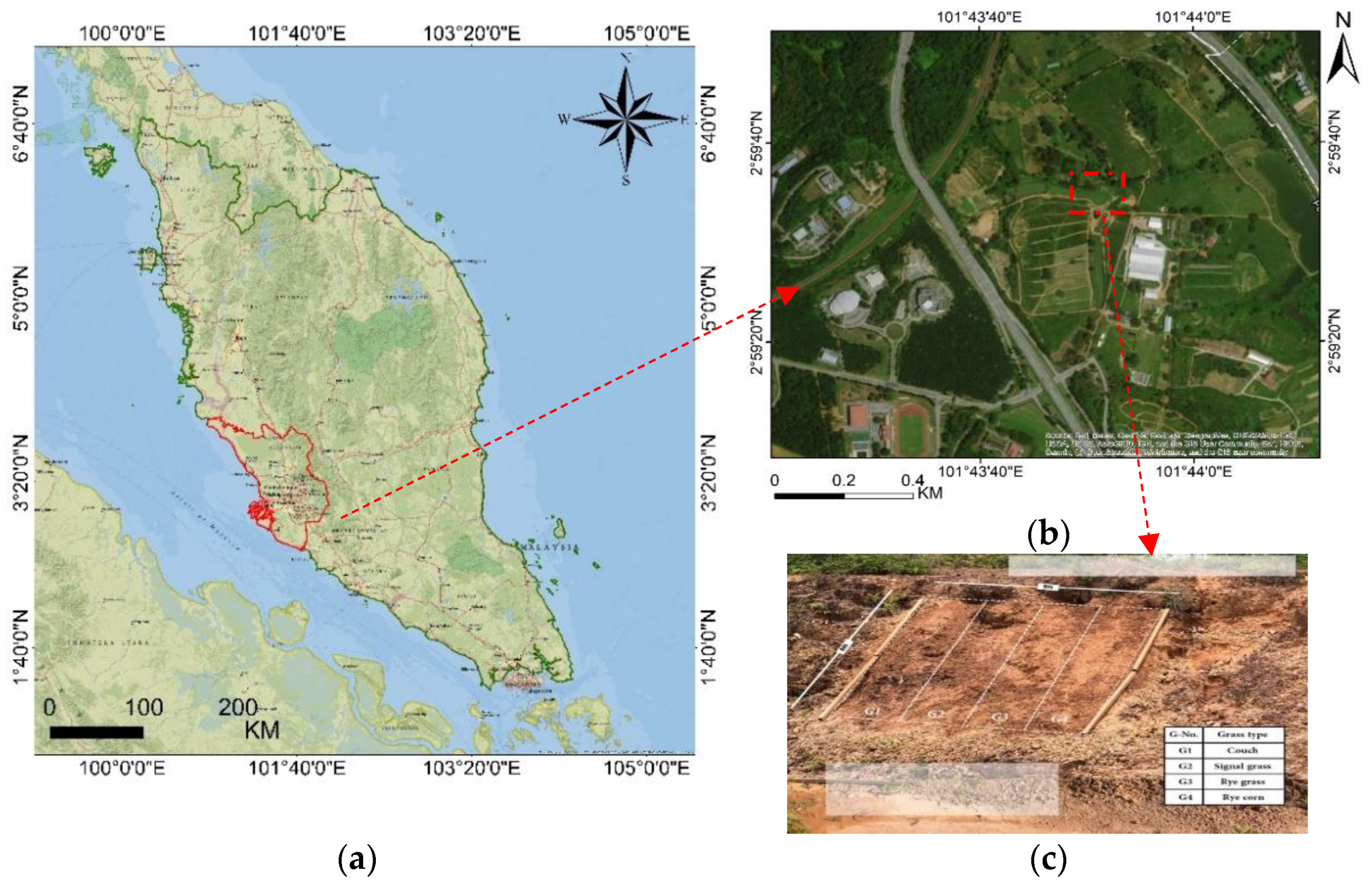
2.1. Study Area
Physical and Chemical Properties of Serdang and Malacca Series
2.2. Data Description
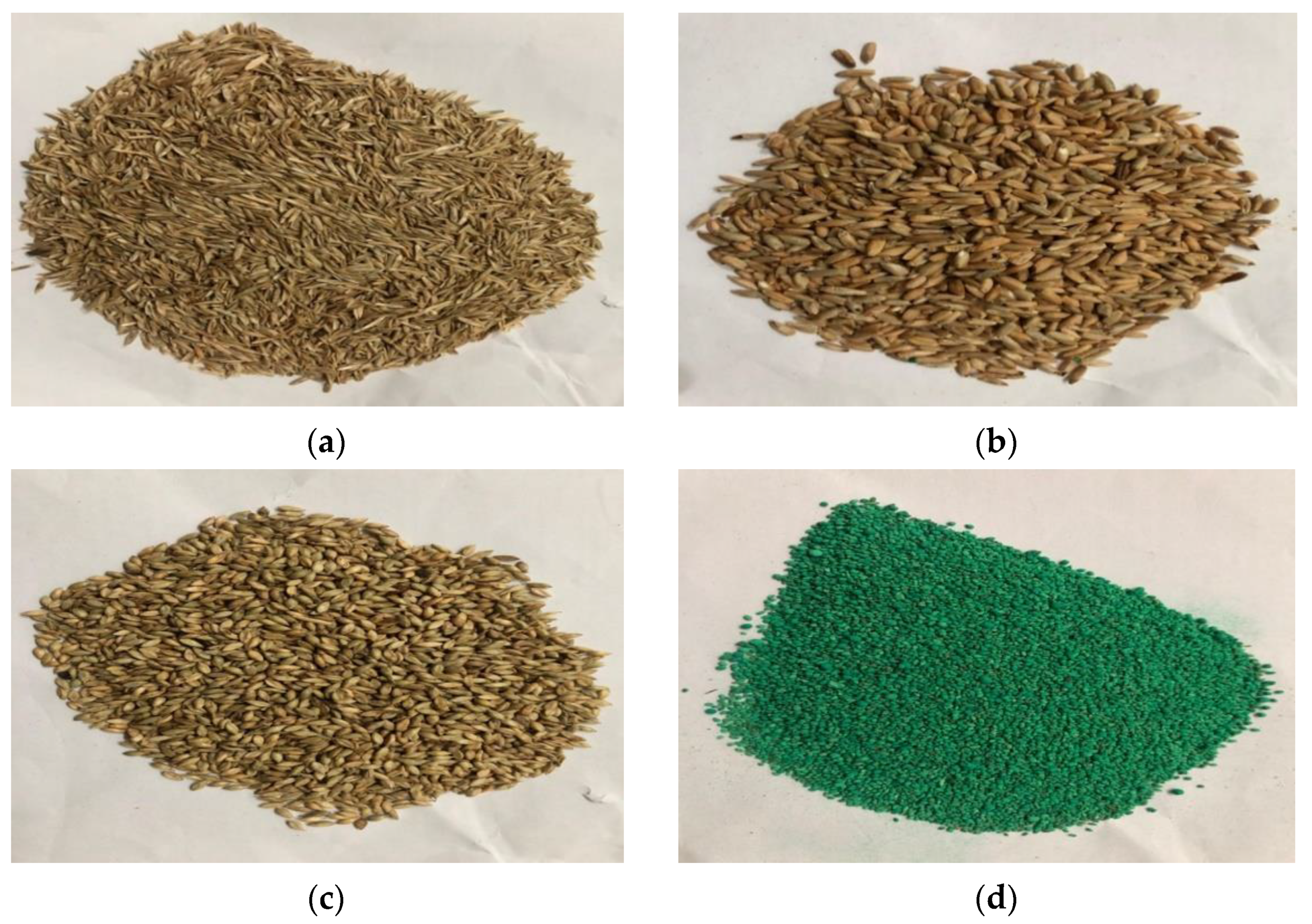
2.2.1. Hydroseeding Mixture
2.2.2. Landslide Inventories and Conditioning Factors
2.2.3. Effects of Climate on Vegetation
3. Methodology
3.1. AHP for Landslide Susceptibility Mapping
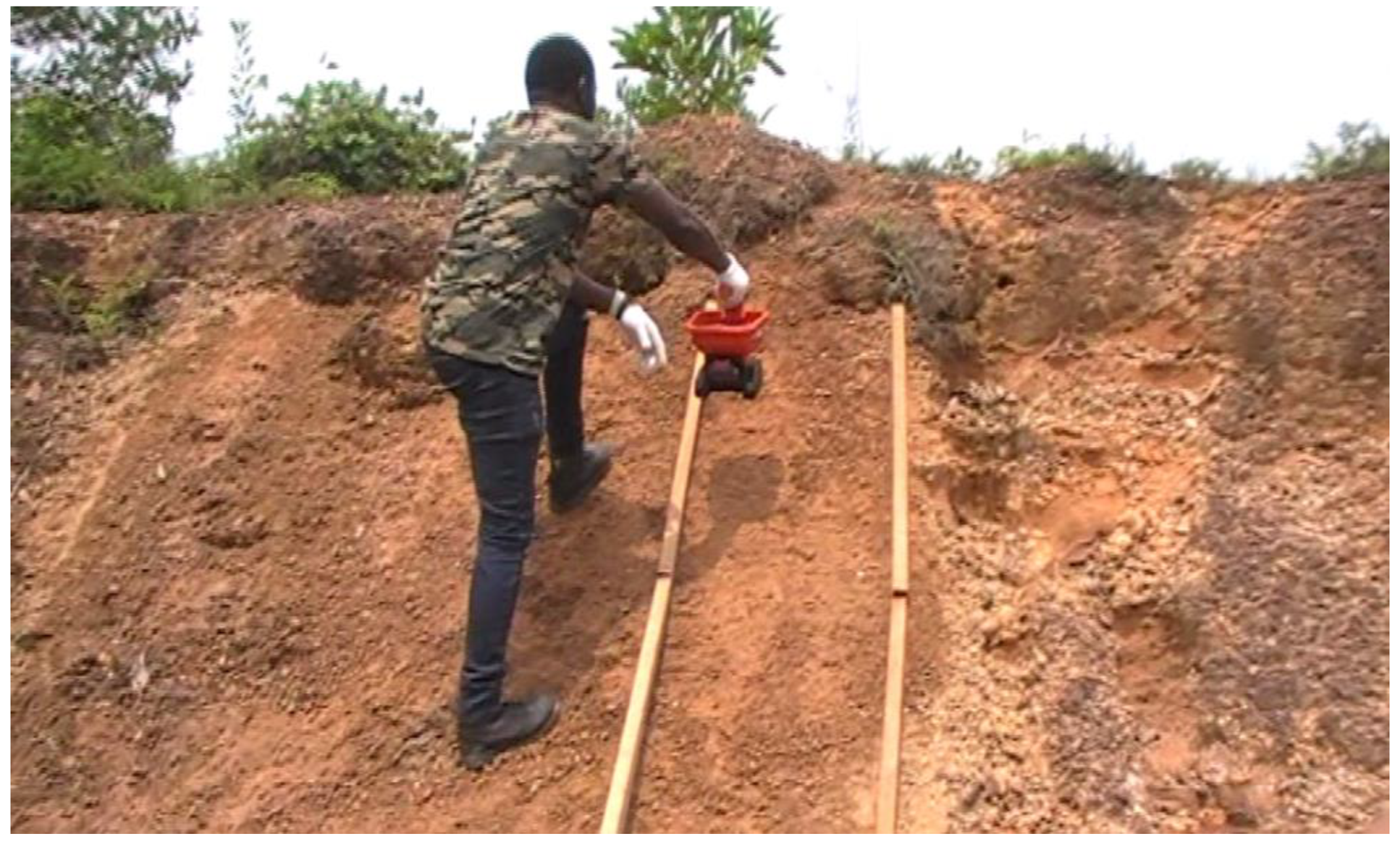
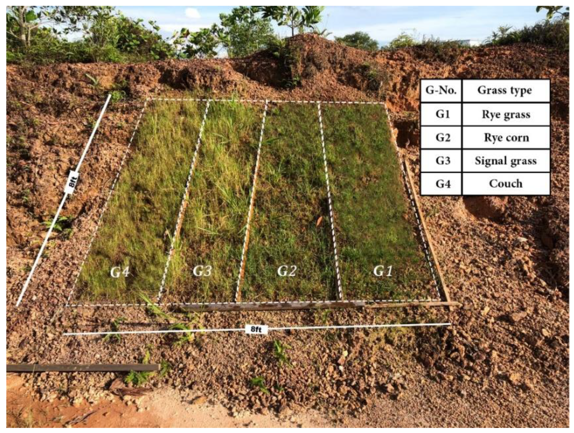
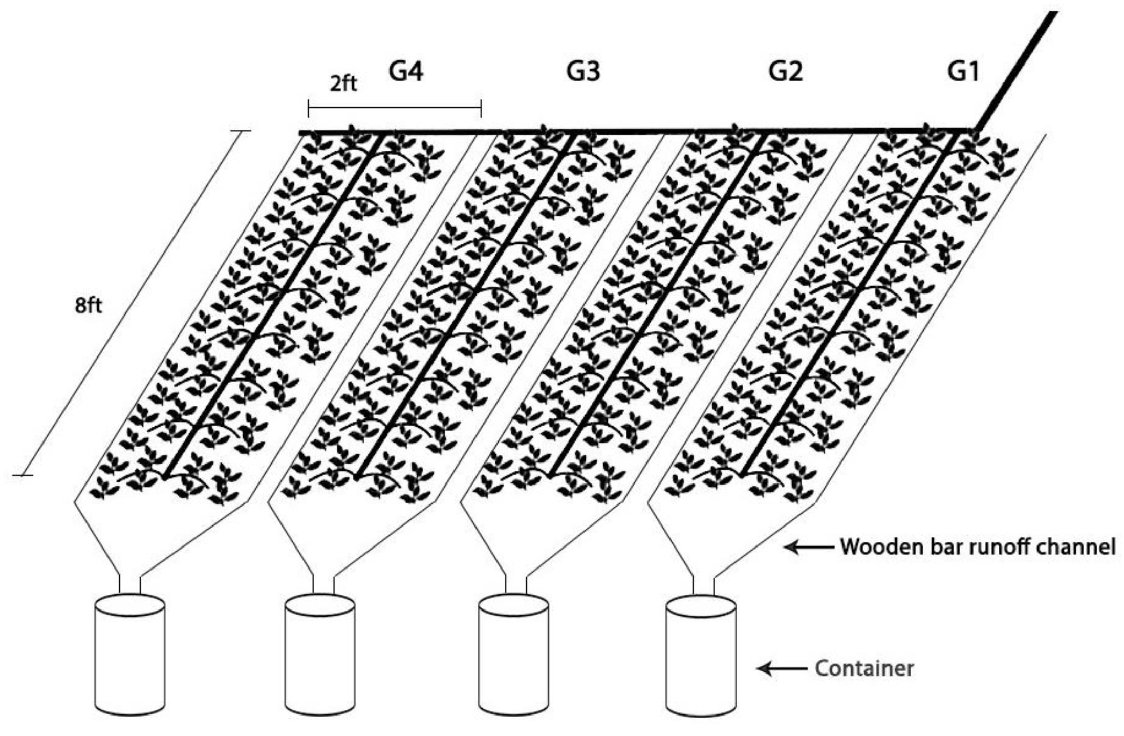
3.2. Field Experimental Design
3.2.1. Vegetation Ground Cover
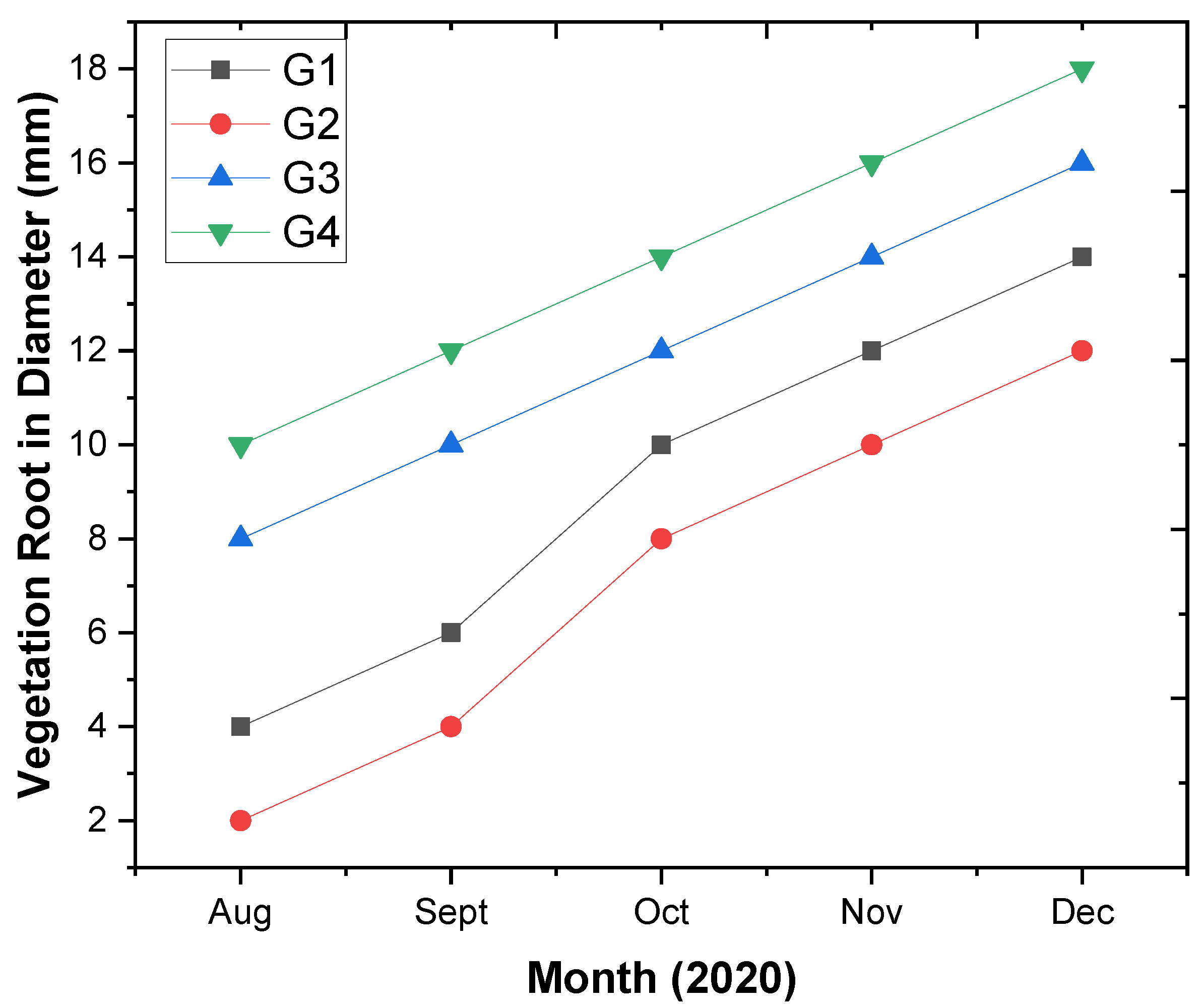
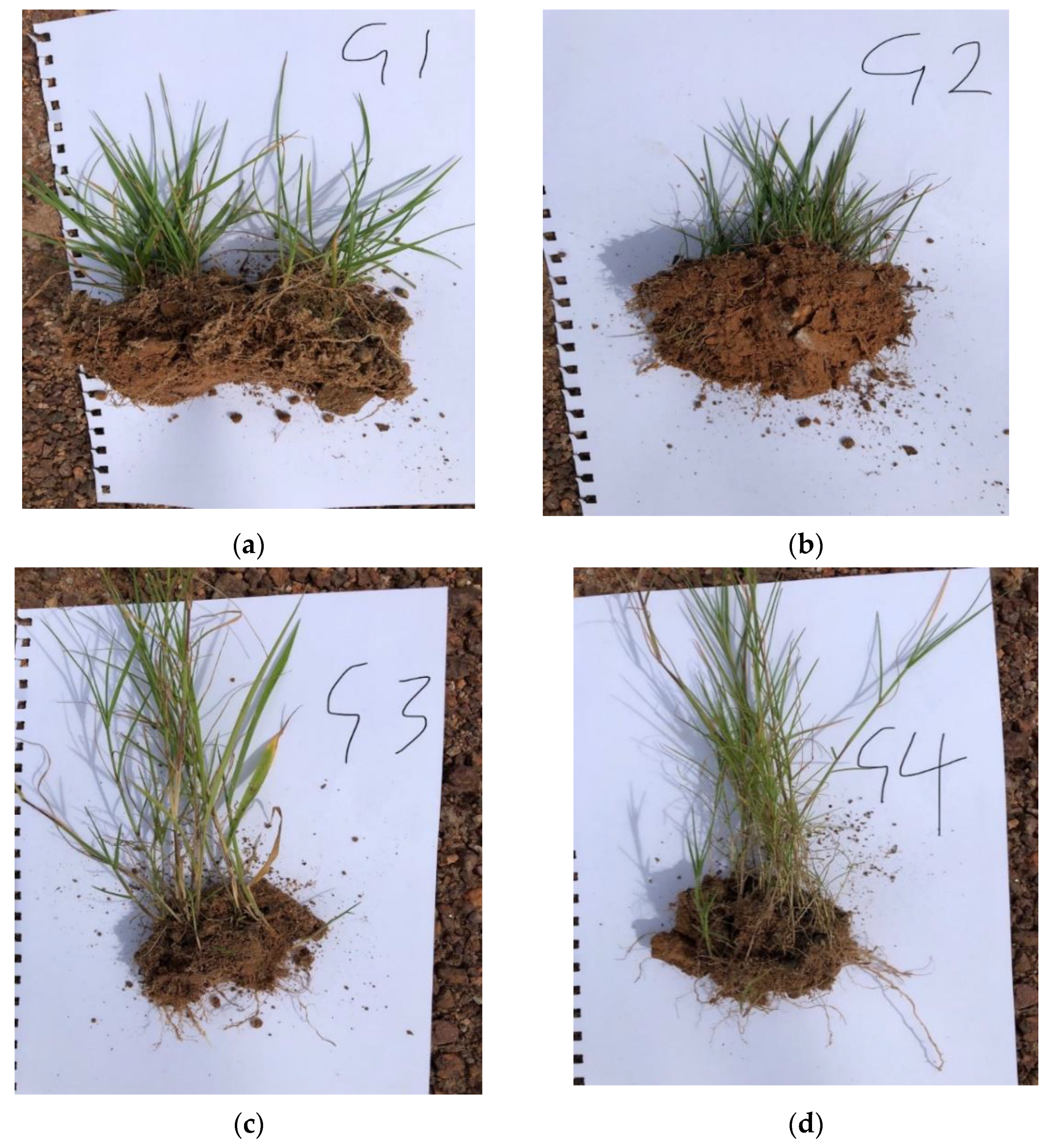
3.2.2. Vegetation Root
3.2.3. Estimation of Surface Runoff
Rational Method
4. Results
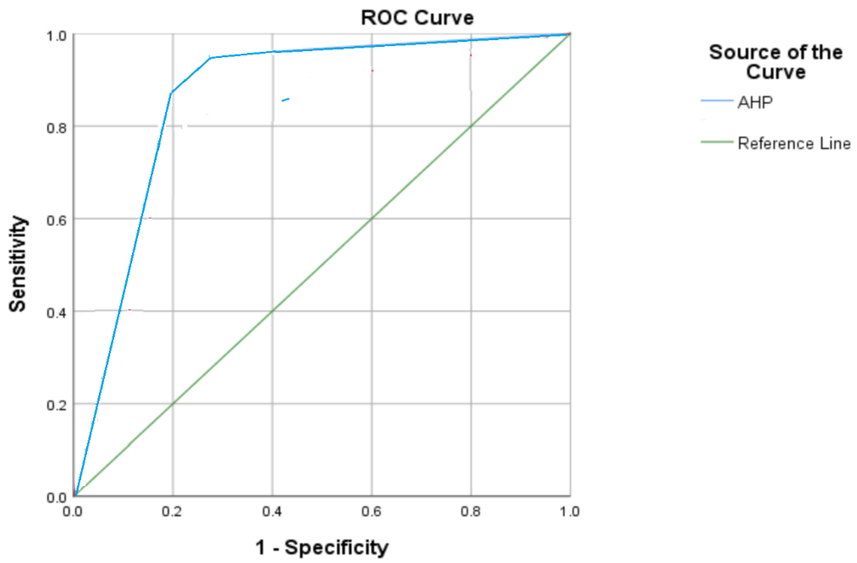
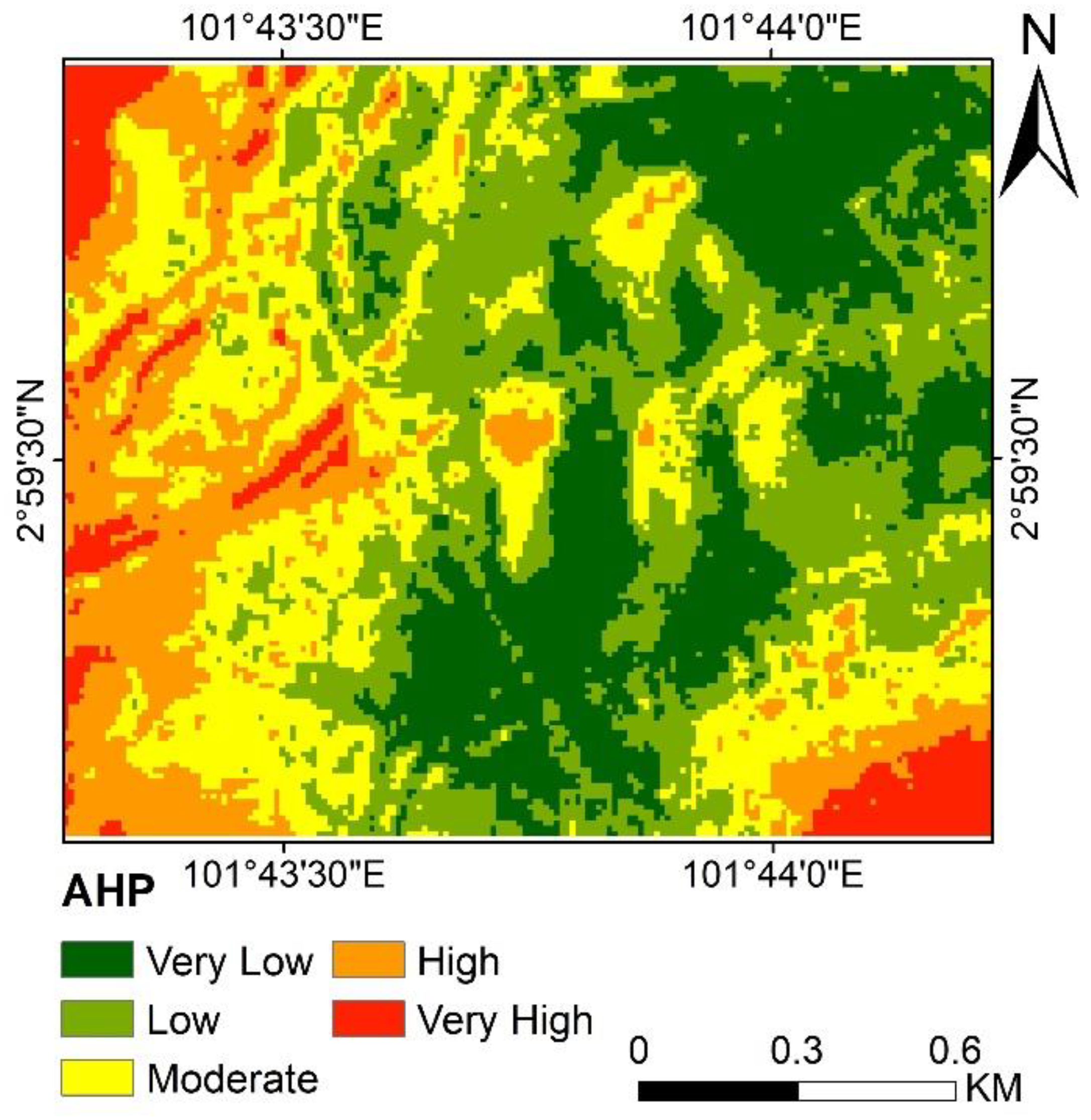
4.1. Landslide Susceptibility Assessment
Validation
4.2. Experimental Observations, Monitoring, and the Result of Hydroseeding
4.2.1. Germination Rate
4.2.2. Vegetation Root Length
4.3. Result of the Hydroseeded Vegetation Ground Cover
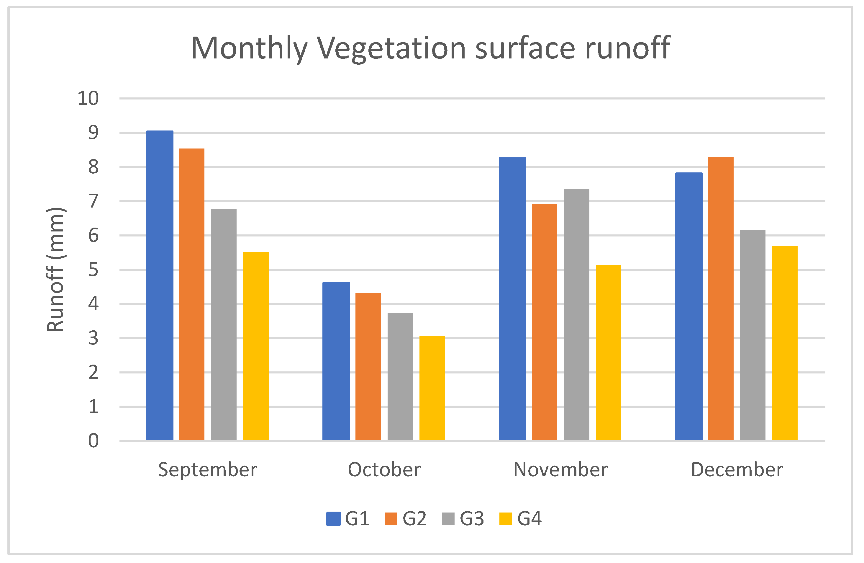
4.4. Vegetation Surface Runoff
5. Discussion
6. Conclusions
Author Contributions
Funding
Institutional Review Board Statement
Informed Consent Statement
Data Availability Statement
Acknowledgments
Conflicts of Interest
References
- Al-Najjar, H.A.H.A.; Pradhan, B.; Kalantar, B.; Sameen, M.I.; Santosh, M.; Alamri, A. Landslide Susceptibility Modeling: An Integrated Novel Method Based on Machine Learning Feature Transformation. Remote Sens. 2021, 13, 3281. [Google Scholar] [CrossRef]
- Kalantar, B.; Ueda, N.; Al-Najjar, H.A.H.; Idrees, M.O.; Motevalli, A.; Pradhan, B. Landslide susceptibility mapping at Dodangeh watershed, Iran using LR and ANN models in GIS. In Proceedings of the SPIE Remote Sensing, Berlin, Germany, 10–13 September 2018; Volume 10790. [Google Scholar]
- Al-Najjar, H.A.H.; Pradhan, B. Spatial landslide susceptibility assessment using machine learning techniques assisted by additional data created with generative adversarial networks. Geosci. Front. 2021, 12, 625–637. [Google Scholar] [CrossRef]
- Kalantar, B.; Ueda, N.; Al-Najjar, H.A.H.; Saeidi, V.; Gibril, M.B.A.; Halin, A.A. A comparison between three conditioning factors dataset for landslide prediction in the sajadrood catchment of iran. ISPRS Ann. Photogramm. Remote Sens. Spat. Inf. Sci. 2020, 5, 625–632. [Google Scholar] [CrossRef]
- Al-Najjar, H.A.H.; Kalantar, B.; Pradhan, B.; Saeidi, V. Conditioning factor determination for mapping and prediction of landslide susceptibility using machine learning algorithms. In Proceedings of the SPIE 11156 Earth Resources Environmental Remote Sensing/GIS Appllications X, Strasbourg, France, 10–12 September 2019; Volume 19. [Google Scholar] [CrossRef]
- Kalantar, B.; Ueda, N.; Lay, U.S.; Al-Najjar, H.A.H.; Halin, A.A. Conditioning factors determination for landslide susceptibility mapping using support vector machine learning. In Proceedings of the IGARSS 2019-2019 IEEE International Geoscience and Remote Sensing Symposium, Yokohama, Japan, 28 July–2 August 2019; pp. 9626–9629. [Google Scholar]
- Kalantar, B.; Ueda, N.; Saeidi, V.; Ahmadi, K.; Halin, A.A.; Shabani, F. Landslide susceptibility mapping: Machine and ensemble learning based on remote sensing big data. Remote Sens. 2020, 12, 1737. [Google Scholar] [CrossRef]
- Psomiadis, E.; Papazachariou, A.; Soulis, K.X.; Alexiou, D.S.; Charalampopoulos, I. Landslide mapping and susceptibility assessment using geospatial analysis and earth observation data. Land 2020, 9, 133. [Google Scholar] [CrossRef]
- Osiński, P.; Rickson, R.J.; Hann, M.J.; Koda, E. Assessment of slope stability influenced by vegetation cover and additional loads applied. Ann. Warsaw Univ. Life Sci. Land Reclam. 2018, 46, 81–91. [Google Scholar] [CrossRef]
- Eugeniusz, K.; Piotr, O. Improvement of Slope Stability as a Result combining diverse reinforcement methods. Architectura 2012, 11, 3–14. [Google Scholar]
- Wang, S.; Zhao, M.; Meng, X.; Chen, G.; Zeng, R.; Yang, Q.; Liu, Y.; Wang, B. Evaluation of the effects of forest on slope stability and its implications for forest management: A case study of Bailong River Basin, China. Sustainability 2020, 12, 6655. [Google Scholar] [CrossRef]
- Ali, N.; Farshchi, I.; Mu’azu, M.A.; Rees, S.W. Soil-root interaction and effects on slope stability analysis. Electron. J. Geotech. Eng. 2012, 17C, 319–328. [Google Scholar]
- Popescu, M. A suggested method for reporting landslide remedial measures. Bull. Eng. Geol. Environ. 2001, 60, 69–74. [Google Scholar] [CrossRef]
- Hutchinson, J.N. Some Aspect of morphological and Geotechnical parameters of Landslides, with examples drwan from Italy and elsewhere. Geol. Romana 1994, 30, 5–13. [Google Scholar]
- Popescu, M.E.; Sasahara, K. Engineering Measures for Landslide Disaster Mitigation BT. In Landslides—Disaster Risk Reduction; Sassa, K., Canuti, P., Eds.; Springer: Berlin/Heidelberg, Germany, 2009; pp. 609–631. ISBN 978-3-540-69970-5. [Google Scholar]
- Bakri, N.N.O.; Mydin, M.A.O. General Building Defects: Causes, Symptoms and Remedial Work. Eur. J. Technol. Des. 2014, 3, 4–17. [Google Scholar] [CrossRef]
- Choi, K.Y.; Cheung, R.W.M. Landslide disaster prevention and mitigation through works in Hong Kong. J. Rock Mech. Geotech. Eng. 2013, 5, 354–365. [Google Scholar] [CrossRef] [Green Version]
- Sun, J.; Liu, Q.; Li, J.; An, Y. Effects of rainfall infiltration on deep slope failure. Sci. China Ser. G Phys. Mech. Astron. 2009, 52, 108–114. [Google Scholar] [CrossRef]
- Nelson, M.; Saftner, D.; Carranza-Torres, C. Slope Stabilization for Local Government Engineers in Minnesota. In Proceedings of the Congress on Technical Advancement 2017: Construction and Forensic Engineering, Duluth, Minnesota, 10–13 September 2017; pp. 127–138. [Google Scholar] [CrossRef] [Green Version]
- Lacasse, S.; Nadim, F.; Kalsnes, B. Living with landslide risk. Geotech. Eng. J. SEAGS AGSSEA 2010, 41, 4–14. [Google Scholar]
- Noroozi, A.G.; Hajiannia, A. The Effects of Various Factors on Slope Stability. Int. J. Sci. Eng. Investig. 2015, 4, 44–48. [Google Scholar]
- Pham, B.T.; Tien Bui, D.; Pourghasemi, H.R.; Indra, P.; Dholakia, M.B. Landslide susceptibility assesssment in the Uttarakhand area (India) using GIS: A comparison study of prediction capability of naïve bayes, multilayer perceptron neural networks, and functional trees methods. Theor. Appl. Climatol. 2017, 128, 255–273. [Google Scholar] [CrossRef]
- Althuwaynee, O.F.; Pradhan, B. Semi-quantitative landslide risk assessment using GIS-based exposure analysis in Kuala Lumpur City. Geomat. Nat. Hazards Risk 2017, 8, 706–732. [Google Scholar] [CrossRef] [Green Version]
- Lacerda, W.; Ehrlich, M.; Fontoura, S.; Sayão, A.; Van Westen, C. Geo-Information tools for landslide risk assessment: An overview of recent developments. Landslides Eval. Stab. Terrain Eval. Stabilisation Set 2 Vol. 2004, 39–56. [Google Scholar] [CrossRef]
- Rasyid, A.R.; Bhandary, N.P.; Yatabe, R. Performance of frequency ratio and logistic regression model in creating GIS based landslides susceptibility map at Lompobattang Mountain, Indonesia. Geoenviron. Disasters 2016, 3, 19. [Google Scholar] [CrossRef] [Green Version]
- Javad, M.; Baharin, A.; Barat, M.; Farshid, S. Using frequency ratio method for spatial landslide prediction. Res. J. Appl. Sci. Eng. Technol. 2014, 7, 3174–3180. [Google Scholar] [CrossRef]
- Wubalem, A. Landslide Susceptibility Mapping Using Statistical Methods in Uatzau Catchment Area, Northwestern Ethiopia. Geoenviron. Disasters 2020, 8, 1. [Google Scholar] [CrossRef]
- Ciurleo, M.; Cascini, L.; Calvello, M. A comparison of statistical and deterministic methods for shallow landslide susceptibility zoning in clayey soils. Eng. Geol. 2017, 223, 71–81. [Google Scholar] [CrossRef]
- Gordo, C.; Zêzere, J.L.; Marques, R. Landslide susceptibility assessment at the basin scale for rainfall- and earthquake-triggered shallow slides. Geosciences 2019, 9, 268. [Google Scholar] [CrossRef] [Green Version]
- Rahman, M.S.; Ahmed, B.; Di, L. Landslide initiation and runout susceptibility modeling in the context of hill cutting and rapid urbanization: A combined approach of weights of evidence and spatial multi-criteria. J. Mt. Sci. 2017, 14, 1919–1937. [Google Scholar] [CrossRef]
- Elmoulat, M.; Brahim, L.A. Landslides susceptibility mapping using GIS and weights of evidence model in Tetouan-ras-Mazari area (Northern Morocco). Geomat. Nat. Hazards Risk 2018, 9, 1306–1325. [Google Scholar] [CrossRef] [Green Version]
- Thiery, Y.; Malet, J.P.; Sterlacchini, S.; Puissant, A.; Maquaire, O. Landslide susceptibility assessment by bivariate methods at large scales: Application to a complex mountainous environment. Geomorphology 2007, 92, 38–59. [Google Scholar] [CrossRef] [Green Version]
- Ghosh, S.; Das, R.; Goswami, B. Developing GIS-based techniques for application of knowledge and data-driven methods of landslide susceptibility mapping. Indian J. Geosci. 2013, 67, 249–272. [Google Scholar]
- Maalouf, M. Logistic regression in data analysis: An overview. Int. J. Data Anal. Tech. Strateg. 2011, 3, 281–299. [Google Scholar] [CrossRef]
- Qiao, G.; Lu, P.; Scaioni, M.; Xu, S.; Tong, X.; Feng, T.; Wu, H.; Chen, W.; Tian, Y.; Wang, W.; et al. Landslide investigation with remote sensing and sensor network: From susceptibility mapping and scaled-down simulation towards in situ sensor network design. Remote Sens. 2013, 5, 4319–4346. [Google Scholar] [CrossRef] [Green Version]
- Polykretis, C.; Ferentinou, M.; Chalkias, C. A comparative study of landslide susceptibility mapping using landslide susceptibility index and artificial neural networks in the Krios River and Krathis River catchments (northern Peloponnesus, Greece). Bull. Eng. Geol. Environ. 2014, 74, 27–45. [Google Scholar] [CrossRef]
- Vakhshoori, V.; Pourghasemi, H.R.; Zare, M.; Blaschke, T. Landslide susceptibility mapping using GIS-based data mining algorithms. Water 2019, 11, 2292. [Google Scholar] [CrossRef] [Green Version]
- Ramachandra, T.V.; Aithal, B.H.; Kumar, U.; Joshi, N.V. Prediction of shallow landslide prone regions in undulating terrains. Disaster Adv. 2013, 6, 54–64. [Google Scholar]
- Al-Najjar, H.A.H.; Kalantar, B.; Pradhan, B.; Saeidi, V.; Halin, A.A.; Ueda, N.; Mansor, S. Land cover classification from fused DSM and UAV images using convolutional neural networks. Remote Sens. 2019, 11, 1461. [Google Scholar] [CrossRef] [Green Version]
- Kalantar, B.; Ueda, N.; Saeidi, V.; Janizadeh, S.; Shabani, F. Deep Neural Network Utilizing Remote Sensing Datasets for Flood Hazard Susceptibility Mapping in Brisbane, Australia. Remote Sens. 2021, 13, 2638. [Google Scholar] [CrossRef]
- Shahabi, H.; Hashim, M. Landslide susceptibility mapping using GIS-based statistical models and Remote sensing data in tropical environment. Sci. Rep. 2015, 5, 9899. [Google Scholar] [CrossRef] [Green Version]
- Nefeslioglu, H.A.; Sezer, E.; Gokceoglu, C.; Bozkir, A.S.; Duman, T.Y. Assessment of Landslide Susceptibility by Decision Trees in the Metropolitan Area of Istanbul, Turkey. Math. Probl. Eng. 2010, 2010, 901095. [Google Scholar] [CrossRef] [Green Version]
- Sarker, I.H. Machine Learning: Algorithms, Real-World Applications and Research Directions. SN Comput. Sci. 2021, 2, 160. [Google Scholar] [CrossRef]
- Tharwat, A. Classification error: Bias and variance, Underfitting and Overfitting. Mach. Learn. Present. 2018. [Google Scholar] [CrossRef]
- Cao, Q.; Banerjee, R.; Gupta, S.; Li, J.; Zhou, W.; Jeyachandra, B. Data Driven Production Forecasting Using Machine Learning. In Proceedings of the SPE Argentina Exploration and Production of Unconventional Resources Symposium, Buenos Aires, Argentina, 1–3 June 2016. [Google Scholar]
- Abdar, M.; Pourpanah, F.; Hussain, S.; Rezazadegan, D.; Liu, L.; Ghavamzadeh, M.; Fieguth, P.; Cao, X.; Khosravi, A.; Acharya, U.R.; et al. A review of uncertainty quantification in deep learning: Techniques, applications and challenges. Inf. Fusion 2021, 76, 243–297. [Google Scholar] [CrossRef]
- Blundell, C.; Cornebise, J.; Kavukcuoglu, K.; Wierstra, D. Weight uncertainty in neural networks. In Proceedings of the 32nd International Conference on Machine Learning, Lille, France, 6–11 July 2015; Volume 2, pp. 1613–1622. [Google Scholar]
- Feizizadeh, B.; Jankowski, P.; Blaschke, T. A Spatially Explicit Approach for Sensitivity and Uncertainty Analysis of GIS-Multicriteria Landslide Susceptibility Mapping; Verlag der Österreichischen Akademie der Wissenschaften: Vienna, Austria, 2013; pp. 157–164. [Google Scholar] [CrossRef] [Green Version]
- Han, B.; Yao, Q.; Yu, X.; Niu, G.; Xu, M.; Hu, W.; Tsang, I.W.; Sugiyama, M. Co-teaching: Robust training of deep neural networks with extremely noisy labels. Adv. Neural Inf. Process. Syst. 2018, 2018, 8527–8537. [Google Scholar]
- Adnan, M.S.G.; Rahman, M.S.; Ahmed, N.; Ahmed, B.; Rabbi, M.F.; Rahman, R.M. Improving spatial agreement in machine learning-based landslide susceptibility mapping. Remote Sens. 2020, 12, 3347. [Google Scholar] [CrossRef]
- Ait Brahim, L.; Bousta, M.; Jemmah, I.A.; El Hamdouni, I.; ElMahsani, A.; Abdelouafi, A.; Sossey alaoui, F.; Lallout, I. Landslide susceptibility mapping using AHP method and GIS in the peninsula of Tangier (Rif-northern morocco). In Proceedings of the MATEC Web Conference, Rabat, Morocco, 22–25 November 2017; Volume 149, p. 02084. [Google Scholar] [CrossRef]
- Moradi, M.; Bazyar, M.H.; Mohammadi, Z. GIS-based landslide susceptibility mapping by AHP method, a case study, Dena City, Iran. J. Basic Appl. Sci. Res. 2012, 2, 6715–6723. [Google Scholar]
- Nguyen, T.T.N.; Liu, C.C. A new approach using AHP to generate landslide susceptibility maps in the chen-yu-lan watershed, Taiwan. Sensors 2019, 19, 505. [Google Scholar] [CrossRef] [Green Version]
- Chou, J.R. A weighted linear combination ranking technique for multi-criteria decision analysis. S. Afr. J. Econ. Manag. Sci. 2013, 16, 28–41. [Google Scholar]
- Malczewski, J. On the use of weighted linear combination method in GIS: Common and best practice approaches. Trans. GIS 2000, 4, 5–22. [Google Scholar] [CrossRef]
- Syst, H.E.; Attribute, C.C. Interactive comment on “A Novel Strategy for landslide displacement and its direction monitoring” by Z.-W. Zhu et al. Nat. Hazards Earth Syst. Sci. Discuss. 2014, 1, C2961–C2962. [Google Scholar]
- Stanley, T.; Kirschbaum, D.B. A heuristic approach to global landslide susceptibility mapping. Nat. Hazards 2017, 87, 145–164. [Google Scholar] [CrossRef] [PubMed] [Green Version]
- Sun, D.; Xu, J.; Wen, H.; Wang, Y. An Optimized Random Forest Model and Its Generalization Ability in Landslide Susceptibility Mapping: Application in Two Areas of Three Gorges Reservoir, China. J. Earth Sci. 2020, 31, 1068–1086. [Google Scholar] [CrossRef]
- Feizizadeh, B.; Shadman Roodposhti, M.; Jankowski, P.; Blaschke, T. A GIS-based extended fuzzy multi-criteria evaluation for landslide susceptibility mapping. Comput. Geosci. 2014, 73, 208–221. [Google Scholar] [CrossRef] [Green Version]
- Loucks, D.P.; van Beek, E. System Sensitivity and Uncertainty Analysis. In Water Resource Systems Planning and Management; Springer: Cham, Switzerland, 2017. [Google Scholar] [CrossRef] [Green Version]
- Ghorbanzadeh, O.; Feizizadeh, B.; Blaschke, T. Multi-criteria risk evaluation by integrating an analytical network process approach into GIS-based sensitivity and uncertainty analyses. Geomat. Nat. Hazards Risk 2018, 9, 127–151. [Google Scholar] [CrossRef] [Green Version]
- Ghosh, S. Knowledge Guided Empirical Prediction of Landslide Hazard; ITC: Enschede, The Netherlands, 2011; ISBN 9789061643104. [Google Scholar]
- Norton, J. An introduction to sensitivity assessment of simulation models. Environ. Model. Softw. 2015, 69, 166–174. [Google Scholar] [CrossRef]
- Guzzetti, F.; Reichenbach, P.; Ardizzone, F.; Cardinali, M.; Galli, M. Estimating the quality of landslide susceptibility models. Geomorphology 2006, 81, 166–184. [Google Scholar] [CrossRef]
- Sterlacchini, S.; Ballabio, C.; Blahut, J.; Masetti, M.; Sorichetta, A. Spatial agreement of predicted patterns in landslide susceptibility maps. Geomorphology 2011, 125, 51–61. [Google Scholar] [CrossRef]
- Noorollahi, Y. Landslide modelling and susceptibility mapping using AHP and fuzzy approaches. Int. J. Hydrol. 2018, 2, 137–148. [Google Scholar] [CrossRef]
- Grozavu, A.; Patriche, C.; Mihai, F. Application of ahp method for mapping slope geomorphic phenomena. Int. Multidiscip. Sci. GeoConference Surv. Geol. Min. Ecol. Manag. SGEM 2017, 17, 377–384. [Google Scholar] [CrossRef]
- He, H.; Hu, D.; Sun, Q.; Zhu, L.; Liu, Y. A landslide susceptibility assessment method based on GIS technology and an AHP-weighted information content method: A case study of southern Anhui, China. ISPRS Int. J. Geo-Inf. 2019, 8, 266. [Google Scholar] [CrossRef] [Green Version]
- Parsakhoo, A.; Jajouzadeh, M.; Motlagh, A.R. Effect of hydroseeding on grass yield and water use efficiency on forest road artificial soil slopes. J. For. Sci. 2018, 64, 157–163. [Google Scholar] [CrossRef] [Green Version]
- Vallone, M.; Pipitone, F.; Alleri, M.; Febo, P.; Catania, P. Hydroseeding application on degraded slopes in the southern Mediterranean area (Sicily). Appl. Eng. Agric. 2013, 29, 309–319. [Google Scholar] [CrossRef] [Green Version]
- Drake, D. Assessment of Hydroplanting Techniques and Herbicide. Master’s Thesis, University of Hawai’i System, Honolulu, HI, USA, 2009. [Google Scholar]
- Stokes, A.; Douglas, G.B.; Fourcaud, T.; Giadrossich, F.; Gillies, C.; Hubble, T.; Kim, J.H.; Loades, K.W.; Mao, Z.; Mcivor, I.R.; et al. Ecological mitigation of hillslope instability: Ten key issues facing researchers and practitioners. Plant Soil 2014, 377, 1–23. [Google Scholar] [CrossRef] [Green Version]
- Kumarasinghe, U. A review on new technologies in soil erosion management. J. Res. Technol. Eng. 2021, 2, 120–127. [Google Scholar]
- Cereno, M.M.; Tan, F.J.; Uy, F.A.A. Combined Hydroseeding and Coconet Reinforcement for Soil Erosion Control. Soil Eros. Stud. 2011, 2–15. [Google Scholar] [CrossRef] [Green Version]
- Faucette, L.B.; Risse, M.; Jordan, C.F.; Cabrera, M.; Coleman, D.C.; West, L.T. Vegetation and soil quality effects from hydroseed and compost blankets used for erosion control in construction activities. J. Soil Water Conserv. 2006, 61, 2–8. [Google Scholar] [CrossRef]
- Blankenship, W.D.; Condon, L.A.; Pyke, D.A. Hydroseeding tackifiers and dryland moss restoration potential. Restor. Ecol. 2019, 28, S127–S138. [Google Scholar] [CrossRef] [Green Version]
- Rivera, D.; Mejías, V.; Jáuregui, B.M.; Costa-Tenorio, M.; López-Archilla, A.I.; Peco, B. Spreading Topsoil Encourages Ecological Restoration on Embankments: Soil Fertility, Microbial Activity and Vegetation Cover. PLoS ONE 2014, 9, e101413. [Google Scholar] [CrossRef] [Green Version]
- Heyes, S.; Butler, M.; Gartlan, C.; Ovington, A. Corangamite Seed Supply & Revegetation Project. 2008. Available online: https://www.ccmaknowledgebase.vic.gov.au/resources/Developing_seed_production_areas_for_native_plants.pdf (accessed on 24 August 2021).
- Farhani, N.B.Y. Evaluation of Geological Formation for Potential Groundwater Aquifer by Integrated by Geophysical Technique. Available online: http://psasir.upm.edu.my/id/eprint/76090 (accessed on 5 September 2021).
- Paramananthan, S.; Daud, N. Classification of Acid Sulfate Soils of Peninsular Malaysia. Pertanika 1986, 9, 323–330. [Google Scholar]
- William, J. Chancellor Soil Physical Properties. Adv. Soil Dyn. 2013, 1, 21–254. [Google Scholar] [CrossRef]
- Ghani, M.A.; Ghani, A. Petrology of granitic rocks along new Pos Selim to Kampung Raja highway (km 0 to km 22): Identification of different granitic bodies, its field and petrographic characteristics. Bull. Geol. Soc. Malays. 2003, 46, 35–40. [Google Scholar] [CrossRef] [Green Version]
- Fatai, A.A.; Shamshuddin, J.; Fauziah, C.I.; Radziah, O.; Bohluli, M. Formation and characteristics of an Ultisol in Peninsular Malaysia utilized for oil palm production. Solid Earth 2017, 1–21. [Google Scholar] [CrossRef]
- Zhao, C.; Liu, B.; Piao, S.; Wang, X.; Lobell, D.B.; Huang, Y.; Huang, M.; Yao, Y.; Bassu, S.; Ciais, P.; et al. Temperature increase reduces global yields of major crops in four independent estimates. Proc. Natl. Acad. Sci. USA 2017, 114, 9326–9331. [Google Scholar] [CrossRef] [PubMed] [Green Version]
- Chen, H.; Zhang, W.; Gao, H.; Nie, N. Climate change and anthropogenic impacts on wetland and agriculture in the Songnen and Sanjiang Plain, northeast China. Remote Sens. 2018, 10, 356. [Google Scholar] [CrossRef] [Green Version]
- Grozavu, A.; Patriche, C.V. Mapping landslide susceptibility at national scale by spatial multi-criteria evaluation. Geomat. Nat. Hazards Risk 2021, 12, 1127–1152. [Google Scholar] [CrossRef]
- Bahrami, Y.; Hassani, H.; Maghsoudi, A. Landslide susceptibility mapping using AHP and fuzzy methods in the Gilan province, Iran. GeoJournal 2021, 86, 1797–1816. [Google Scholar] [CrossRef]
- Cerdà, A. Soil water erosion on road embankments in eastern Spain. Sci. Total Environ. 2007, 378, 151–155. [Google Scholar] [CrossRef] [PubMed]
- Pan, C.; Shangguan, Z. Runoff hydraulic characteristics and sediment generation in sloped grassplots under simulated rainfall conditions. J. Hydrol. 2006, 331, 178–185. [Google Scholar] [CrossRef]
- Gaurina-Medjimurec, N. Handbook of Research on Advancements in Environmental Engineering; IGI Global: Hershey, PA, USA, 2014; ISBN 9781466673373. [Google Scholar]
- Yen, C. Study on the root system form and distribution habit of the ligneous plants for soil conservation in Taiwan. J. Chin. Soil Water Conserv. 1972, 3, 179–204. [Google Scholar]
- Zhao, B.; Zhang, L.; Xia, Z.; Xu, W.; Xia, L.; Liang, Y.; Xia, D. Effects of Rainfall Intensity and Vegetation Cover on Erosion Characteristics of a Soil Containing Rock Fragments Slope. Adv. Civ. Eng. 2019, 2019, 7043428. [Google Scholar] [CrossRef]
- Wu, L.; Peng, M.; Qiao, S.; Ma, X. Effects of rainfall intensity and slope gradient on runoff and sediment yield characteristics of bare loess soil. Environ. Sci. Pollut. Res. 2018, 25, 3480–3487. [Google Scholar] [CrossRef]
- Li, X.; Niu, J.; Xie, B. The effect of leaf litter cover on surface runoff and Soil Erosion in Northern China. PLoS ONE 2014, 9, e107789. [Google Scholar] [CrossRef] [Green Version]
- Repel, A. Developing of the rainfall intensity-duration-frequency curves for the Kosice region using multiple computational models. IOP Conf. Ser. Mater. Sci. Eng. 2019, 566, 012026. [Google Scholar] [CrossRef]
- Gámez-Balmaceda, E.; López-Ramos, A.; Martínez-Acosta, L.; Medrano-Barboza, J.P.; López, J.F.R.; Seingier, G.; Daesslé, L.W.; López-Lambraño, A.A. Rainfall intensity-duration-frequency relationship. Case study: Depth-duration ratio in a semi-arid zone in Mexico. Hydrology 2020, 7, 78. [Google Scholar] [CrossRef]
- Fantina, D.E. A Comparison of Runoff Estimation Techniques. 2012. Available online: https://www.suncam.com/courses/100233-06.html (accessed on 24 August 2021).
- Meena, S.R.; Ghorbanzadeh, O.; Blaschke, T. A comparative study of statistics-based landslide susceptibility models: A case study of the region affected by the Gorkha earthquake in Nepal. ISPRS Int. J. Geo-Inf. 2019, 8, 94. [Google Scholar] [CrossRef] [Green Version]
- Al-Shabeeb, A.R.; Al-Adamat, R.; Mashagbah, A. AHP with GIS for a Preliminary Site Selection of Wind Turbines in the North West of Jordan. Int. J. Geosci. 2016, 7, 1208–1221. [Google Scholar] [CrossRef] [Green Version]
- Rossi, M.; Reichenbach, P. LAND-SE: A software for statistically based landslide susceptibility zonation, version 1.0. Geosci. Model Dev. 2016, 9, 3533–3543. [Google Scholar] [CrossRef] [Green Version]
- Tazik, E.; Jahantab, Z.; Bakhtiari, M.; Rezaei, A.; Alavipanah, S.K. Landslide susceptibility mapping by combining the three methods Fuzzy Logic, Frequency Ratio and Analytical Hierarchy Process in Dozain basin. Int. Arch. Photogramm. Remote Sens. Spat. Inf. Sci. 2014, 40, 267. [Google Scholar] [CrossRef] [Green Version]
- Gigović, L.; Drobnjak, S.; Pamučar, D. The application of the hybrid GIS spatial multi-criteria decision analysis best–worst methodology for landslide susceptibility mapping. ISPRS Int. J. Geo-Inf. 2019, 8, 79. [Google Scholar] [CrossRef] [Green Version]
- SafeLand Recommended Procedures for Validating Landslide Hazard and Risk Models and Maps, Report. 2011. Available online: https://www.ngi.no/download/file/5994 (accessed on 24 August 2021).
- Baets, S.; Poesen, J. Empirical models for predicting the erosion-reducing effect of plant roots during concentrated flow. Geomorphology 2010, 118, 425–432. [Google Scholar] [CrossRef]
- Vannoppen, W.; Vanmaercke, M.; De Baets, S.; Poesen, J. A review of the mechanical effects of plant roots on concentrated flow erosion rates. Earth-Sci. Rev. 2015, 150, 666–678. [Google Scholar] [CrossRef] [Green Version]
- Chen, G.; Weil, R.R. Penetration of cover crop roots through compacted soils. Plant Soil 2010, 331, 31–43. [Google Scholar] [CrossRef]
- Najafi, S.; Dragovich, D.; Heckmann, T.; Sadeghi, S.H. Sediment connectivity concepts and approaches. Catena 2021, 196, 104880. [Google Scholar] [CrossRef]
- Luo, J.; Zhou, X.; Rubinato, M.; Li, G.; Tian, Y.; Zhou, J. Impact of multiple vegetation covers on surface runoff and sediment yield in the small basin of nverzhai, hunan province, China. Forests 2020, 11, 329. [Google Scholar] [CrossRef] [Green Version]
- Bochet, E.; García-Fayos, P.; Alborch, B.; Tormo, J. Soil water availability effects on seed germination account for species segregation in semiarid roadslopes. Plant Soil 2007, 295, 179–191. [Google Scholar] [CrossRef]
- García-Palacios, P.; Bowker, M.A.; Chapman, S.J.; Maestre, F.T.; Soliveres, S.; Gallardo, A.; Valladares, F.; Guerrero, C.; Escudero, A. Early-successional vegetation changes after roadside prairie restoration modify processes related with soil functioning by changing microbial functional diversity. Soil Biol. Biochem. 2011, 43, 1245–1253. [Google Scholar] [CrossRef]
- Risse, M.; Cabrera, M.; Coleman, D.C.; West, L.T. Contaminated Soils, Sediments and Water. In Contaminated Soils Sediments Water; Springer: Berlin/Heidelberg, Germany, 2006. [Google Scholar] [CrossRef]
- Kim, J.H.; Fourcaud, T.; Jourdan, C.; Maeght, J.L.; Mao, Z.; Metayer, J.; Meylan, L.; Pierret, A.; Rapidel, B.; Roupsard, O.; et al. Vegetation as a driver of temporal variations in slope stability: The impact of hydrological processes. Geophys. Res. Lett. 2017, 44, 4897–4907. [Google Scholar] [CrossRef]


| Properties | Description |
|---|---|
| Location | UPM, Serdang |
| Slope angle | 65 degrees |
| Soil type | Serdang (Typic Kandiudults) and Malacca Series (Typic Hapludox) |
| Precipitation | 2400 mm annually |
| Humidity | The average annual percentage of humidity is: 80.0% |
| Temperature | 22 to 33 °C |
| Properties | Serdang Series | Malacca Series | |
|---|---|---|---|
| Depth (m) Soil texture | Topsoil 0.1 Subsoil 1.5 Sandy clay loam to sandy clay | 0.1 1.5 Clay and Sand | |
| Bulk density (grcm−3) | Topsoil | 1.47 and 1.42 | 1.36 and 1.27 |
| Subsoil | 1.48 to 1.49 and 1.44 to 1.45 | 1.37 to 1.41 to 1.30 to 1.32 | |
| Porosity (%) | Topsoil | 36.8 and 38.26 | 41.37 and 47.08 |
| Subsoil | 30.15 to 21.87 and 344 to 23.15 | 29.15 to 34.12 and 42.22 to 34.51 | |
| Water holding capacity (%) | Topsoil 33 kPa | 23.02 to 16.61 | 23.83 to 21.51 |
| Subsoil 33 kPa | 21.16 to 17.01 | 23.72 to 21.81 | |
| Soil pH (%) | Topsoil 1500 kPa | 12.59 to 7.58 | 10.75 to 10.77 |
| Subsoil 1500 kPa | 11.97 to 8.36 | 10.29 to 13.23 | |
| Topsoil | 4.99 to 4.90 | 4.47 and 5.30 | |
| Subsoil | 5.68 to 5.22 | ||
| Seeds | Quantity (kg) | Origin | Price per kg (AUD) |
|---|---|---|---|
| Rye grass (Lolium perenne L.) | 1 kg | Europe, Asia and northern Africa | 5.10 |
| Rye corn (Secale cereale) | 1 kg | Turkey | 1.90 |
| Signal grass (Brachiaria Decumbens/Urochioa Decumbens) | 1 kg | Uganda | 16.50 |
| Couch Bermuda grass (Cynodon dactylon) | 1 kg | Afro-Eurasia and Australia | 24.00 |
| Jan. | Feb. | Mar. | Apr. | May | Jun. | Jul. | Aug. | Sept. | Oct. | Nov. | Dec. | |
|---|---|---|---|---|---|---|---|---|---|---|---|---|
| Avg. Temperature °C (°F) | 25.1 | 25.7 | 26 | 26.1 | 26.3 | 26.2 | 26.1 | 26 | 25.8 | 25.7 | 25.2 | 25.1 |
| (77.2) | (78.3) | (78.8) | (78.9) | (79.3) | (79.2) | (78.9) | (78.8) | (78.5) | (78.2) | (77.4) | (77.2) | |
| Min Temperature °C (°F) | 21.9 | 21.9 | 22.7 | 23.1 | 23.4 | 23.1 | 22.8 | 22.8 | 22.8 | 22.8 | 22.7 | 22.3 |
| (71.4) | (71.4) | (72.8) | (73.6) | (74.1) | (73.5) | (73.1) | (73.1) | (73) | (73) | (72.8) | (72.2) | |
| Max Temperature °C (°F) | 209 | 174 | 268 | 300 | 246 | 174 | 183 | 219 | 243 | 308 | 373 | 284 |
| (8.2) | (6.9) | (10.6) | (11.8) | (9.7) | (6.9) | (7.2) | (8.6) | (9.6) | (12.1) | (14.7) | (11.2) | |
| Precipitation/Rainfall mm (in) | 209 | 174 | 268 | 300 | 246 | 174 | 183 | 219 | 243 | 308 | 373 | 284 |
| (8.2) | (6.9) | (10.6) | (11.8) | (9.7) | (6.9) | (7.2) | (8.6) | (9.6) | (12.1) | (14.7) | (11.2) | |
| Humidity | 85% | 82% | 85% | 87% | 87% | 85% | 84% | 84% | 85% | 87% | 90% | 88% |
| Rainy days | 20 | 18 | 24 | 27 | 25 | 22 | 24 | 24 | 25 | 26 | 26 | 24 |
| Date | Rainfall (mm/h) | G1 Runoff (mm) | G2 Runoff (mm) | G3 Runoff (mm) | G4 Runoff (mm) |
|---|---|---|---|---|---|
| September | 35 | 9.03 | 8.53 | 6.77 | 5.52 |
| October | 48 | 4.62 | 4.32 | 3.73 | 3.05 |
| November | 33 | 8.25 | 6.91 | 7.36 | 5.13 |
| December | 34 | 7.81 | 8.28 | 6.15 | 5.68 |
Publisher’s Note: MDPI stays neutral with regard to jurisdictional claims in published maps and institutional affiliations. |
© 2021 by the authors. Licensee MDPI, Basel, Switzerland. This article is an open access article distributed under the terms and conditions of the Creative Commons Attribution (CC BY) license (https://creativecommons.org/licenses/by/4.0/).
Share and Cite
Emeka, O.J.; Nahazanan, H.; Kalantar, B.; Khuzaimah, Z.; Sani, O.S. Evaluation of the Effect of Hydroseeded Vegetation for Slope Reinforcement. Land 2021, 10, 995. https://doi.org/10.3390/land10100995
Emeka OJ, Nahazanan H, Kalantar B, Khuzaimah Z, Sani OS. Evaluation of the Effect of Hydroseeded Vegetation for Slope Reinforcement. Land. 2021; 10(10):995. https://doi.org/10.3390/land10100995
Chicago/Turabian StyleEmeka, Okoli Jude, Haslinda Nahazanan, Bahareh Kalantar, Zailani Khuzaimah, and Ojogbane Success Sani. 2021. "Evaluation of the Effect of Hydroseeded Vegetation for Slope Reinforcement" Land 10, no. 10: 995. https://doi.org/10.3390/land10100995
APA StyleEmeka, O. J., Nahazanan, H., Kalantar, B., Khuzaimah, Z., & Sani, O. S. (2021). Evaluation of the Effect of Hydroseeded Vegetation for Slope Reinforcement. Land, 10(10), 995. https://doi.org/10.3390/land10100995