1. Introduction
Cadastre is normally a parcel based, and up-to-date land information system containing a record of interests in land (e.g., rights, restrictions, and responsibilities). It usually includes a geometric description of land parcels linked to other records describing the nature of the interests, the ownership or control of those interests, and often the value of the parcel and its improvements. It may be established for fiscal purposes (e.g., valuation and equitable taxation), legal purposes (conveyancing), to assist in the management of land and land use (e.g., for planning and other administrative purposes), and enables sustainable development and environmental protection [
1].
Cadastre used to be a set of technical and alphanumerical documents in which a certain amount of information was contained about cadastral parcels and the immovable objects located on these parcels [
2]. The technical dataset contains measurement data, coordinates of permanent geodetic points and maps, the most important of which is the cadastral map. The measured data are on the sketches and in the protocols. Before digitization, technical and alphanumerical datasets were maintained separately. Separate data maintenance caused redundancy, which further led to inconsistencies between the cadastral map and the register data.
Urbanization, changing population demographics, advances in technology, and other major global trends are affecting every individual and organization around the world. Collaboration and data exchange are very important in all economy branches, including the land administration systems. A cadastre, as one of the key registers of land administration, plays a role in granting access to land information and maintaining cadastral data in accordance with the changes that occur on land [
3]. It could be stated that the interaction between the cadastral parcel and the other data is essential and should be guaranteed as correct. Registers, such are the cadasters, which provide authoritative data [
4,
5,
6], play an important role in protecting the members of the public against the claims of others that are wrongfully attributed to their property. This can also mean protecting them against the government [
7].
To understand the complexity and data quality of a cadastre in a specific country, the historical development must be known, besides the current organization and procedures. With the progress of IT technology, cadasters have developed into a key component of a land information system, which, together with other registers, provides up-to-date land information [
8,
9].
A cadastral map is the key component of cadastral documentation, as it provides the geometric and positional definition of cadastral parcels. Their assortment diversity is determined by the period of their origin, surveying method of updating, and renewal. The fact that cadastral maps are today in the electronic form does not guarantee their accuracy and quality [
10].
In the recent decades, many countries worldwide have taken measures to establish cadasters by surveys, such as in Greece [
11], or to translate the existing paper-based cadastral data into the electronic form to ensure the continuous accomplishment of surveying tasks related to real property registration [
12]. Modern land administration systems are increasingly being analyzed considering the fit-for-purpose approach because of the complexity, high costs of running and maintenance [
13]. The alphanumerical part of the cadastral data, known as the register data, was first translated into the electronic format and stored onto media in databases. The digitalization of cadastral map sheets required further technological advancement as the map sheets had to be scanned, georeferenced, and then vectorized to be stored into a database. These processes were mostly carried out manually, and the quality of digitization depended on the experience and knowledge of the expert executing it. One of the tasks of the digitization of cadastral data was to address the inconsistencies between cadastral data records, but many of the inconsistencies have remained to this day [
14,
15,
16,
17].
Inaccurate data affect the quality of decision-making at the parcel level. The improved quality of spatial information will lead to increased consumer confidence and trust. The technical reliability of cadastral data is a prerequisite to legally secure boundary re-establishment. Many countries and cadastral agencies aim to improve the geometric accuracy of spatial data and to improve the overall quality of a cadastral system. The most common issues that they are facing are insufficient geometric quality of electronic cadastral map and inconsistencies between registered data and the actual situation in the field and out-of-date data already registered, such as land types and land use [
18,
19,
20,
21]. Today, integrity is ensured when modeling databases [
22,
23] or by the appropriate modeling of business processes and the establishment of a cadastral workflow management system [
24]. An inconsistency of the registered data poses challenges on the migration to modern databases and further maintenance.
The integrity of cadastral data can be a precondition for the possibility of switching to electronic management in databases where such a condition must be met [
25]. The research identified significant inconsistencies that significantly complicate the implementation of an integrated cadastral data maintenance system. The spatial accuracy of a vectorized cadastral map is of great importance, but the data integrity is more important [
26,
27], as the cadastral data are used in combination with other data or as a layer in a spatial data infrastructure. Property rights, restrictions, and responsibilities are registered based on cadastral data. Inconsistent cadastral data makes reliable real property transactions difficult. This creates uncertainty in the real property market and hinders economic development and investment.
In the territory of Croatia, the cadastral establishment began in the 19th century during the reign of Austro-Hungarian Monarchy, as the whole area was systematically surveyed and the cadastral documentation was prepared for all the cadastral municipalities. Following the independence in the year 1999, new regulations were being adopted that initiated the radical reform very similar to the Austrian approach [
28]. Instead of the Land Cadastre, the Real Property Cadastre has been introduced [
29]. The so-called Franciscan cadastre was established for the purposes of the taxation of agricultural land. Although it is considered historical, for approximately 75% of the Croatian territory, it is still in everyday use [
30]. Since the establishment of the cadastre, numerous changes have been made through the maintenance of cadastral data, and with the advancement in technology, the need for data digitization has arisen. The register data were stored in databases until 1990, and the cadastral map sheets were translated into the electronic form by vectorization projects at the beginning of the 21st century. Given the mentioned changes in the forms of storing data and all the maintenance throughout time, today, we are facing the inconsistencies between the data stored in the register and the cadastral map data. These inconsistencies were discovered and documented within the quality control of vectorization projects.
The aim of this research was to develop the methodology for analyzing and resolving the inconsistencies between the register and the cadastral map data. Inconsistencies were indicated by the differences resulting from quality control, conducted in the cadastral map vectorization projects, on the basis of the redundant data within the cadastral documentation. An analysis of these differences revealed the possible causes and sources of inconsistencies and the possibility of correction. Furthermore, based on the results of the analyses, the sources and causes of errors were systematized. The following sections in this paper describe the methodology, vectorization process, and quality control defined by the technical instructions, research analysis, and results, discussion, and conclusions.
2. Materials and Methods
Cadastral data, particularly cadastral maps, are used in many different disciplines and for various analysis purposes. A cadastral map is among the most widely used sources for historical land changes because of the robustness of its spatial quantitative information and the visual form of the information, which together makes them easy to analyze. However, there are some limitations arising from the use of a historical cadastral map, such are distortions of the paper before it was scanned and georeferenced and the lack of metadata regarding the quality and basic information (map scale, surveying method, etc.) [
31,
32]. For this research, cadastral maps from different time series and results of vectorization quality control were used.
The quality control procedure for cadastral data has been developed within the development of technical instructions for vectorization [
33]. The procedure is based on the redundant data within the cadastral documentation. Vectorization reports contain the differences in data between the cadastral map and the register. By conducting a detailed analysis of these differences, we discovered the source and the cause of the difference and corrected the error that caused the inconsistency. For the purposes of this research, the results of quality control for three cadastral municipalities were used: Dol, Postira, and Stobreč. The cadastral municipalities Dol and Postira were graphically surveyed, and the cadastral documentation was established in the 19th century. The cadastral municipality Stobreč was resurveyed, and the cadastral documentation was re-established in the 20th century. All three of them were digitized and are today continuously maintained electronically. The cadastral datasets required for the analysis were scanned and georeferenced cadastral map sheets, vectorized cadastral map, and vectorization reports.
Depending on the type of difference, distinct archival data were also used. This refers to the historical cadastral map sheets and register data. The datasets were obtained from the cadastral authority (State Geodetic Administration [
34]), as the data are not publicly available via a web service. Georeferenced and scanned paper cadastral map sheets were provided in the .tif format with the accompanying .tfw files, the vectorized cadastral maps were provided in the .dxf format, and the vectorization reports were provided in the .docx and .xlsx formats. Historical cadastral map sheets for the cadastral municipalities Dol and Postira from the National Archives in Split [
34] were also used for the research.
2.1. Vectorization and Quality Control
The vectorization of the cadastral map in Croatia was carried out from 2002 to 2010 for more than 3300 cadastral municipalities by the private sector. Previously, the technical possibilities in other countries were researched, and in accordance with the specifics of the cadastre in Croatia, a methodology was developed, and technical instructions were issued [
33]. Vectorization was preceded by scanning the sheets of the cadastral map and georeferencing with an affine transformation. The vectors of the cadastral map features were produced by interactive screen vectorization. According to the prescribed model, the data vectors and other elements (text, etc.) of the cadastral map were stored in a CAD file.
Primarily, the official sheets of the cadastral map that was maintained was vectorized. However, due to long-term use, these sheets had shortcomings. In these cases, other documentation was used to obtain missing or illegible content. This mostly refers to historical maps but also to the data of the original cadastral survey if they existed (sketches, photo sketches, measurement protocols). In order to obtain the current situation in the respective area, it was also necessary to use the documentation on the changes that have occurred since the date of origin of the previous data series used.
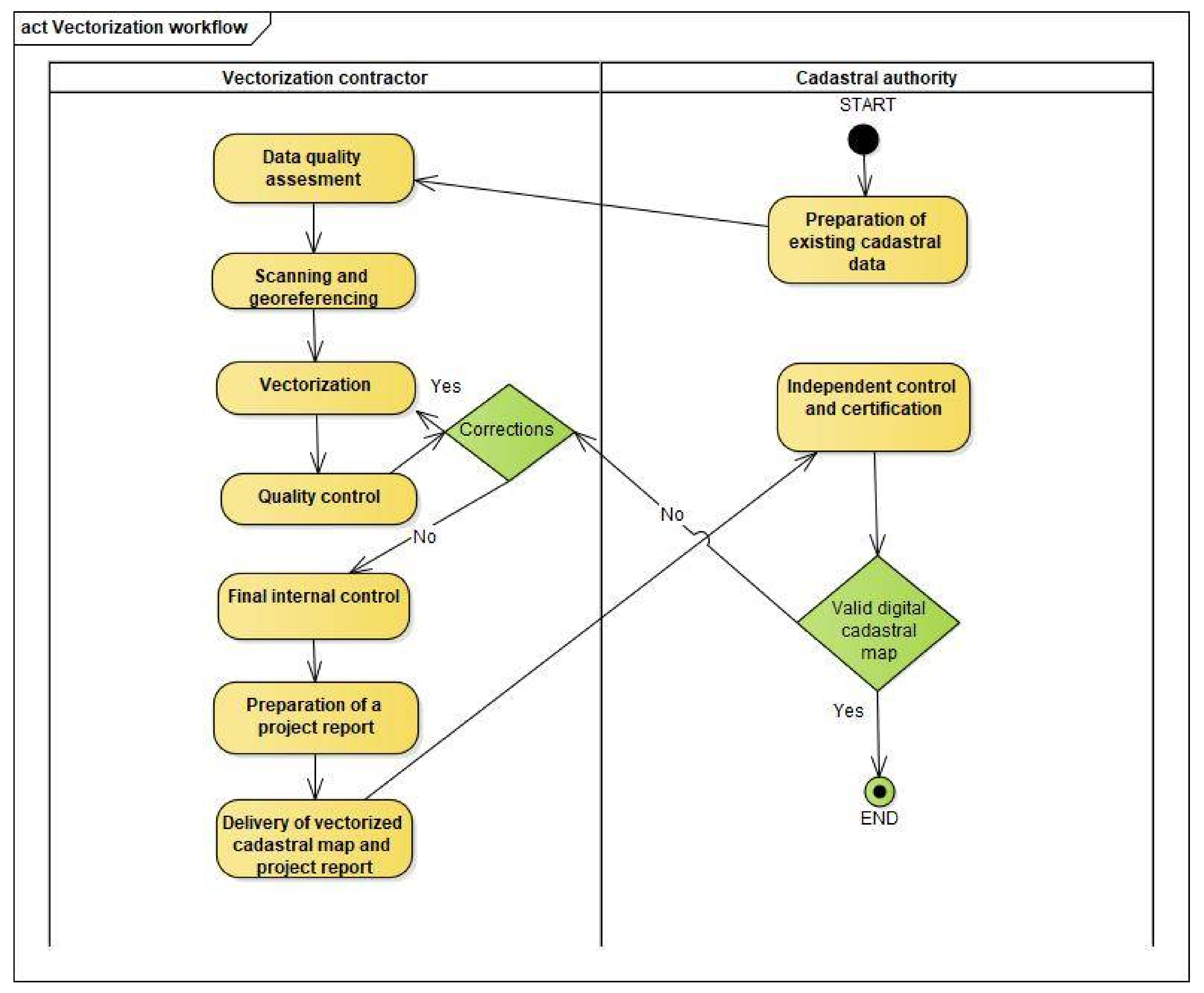
According to the technical instructions, a vectorization project is a complex project involving multiple activities that are performed sequentially (
Figure 1). The project consists of several interconnected tasks that may differ depending on the source data. A vectorization project is performed wholly for the entire cadastral municipality. In addition to the requirements arising from the instructions and the contract, the contractor is obliged to comply with all the national regulations affecting the cadastre.
After contracting the vectorization project, the cadastral authority prepares and submits all the necessary documentation to the contractor. The contractor reviews the documentation and evaluates the quality of the data. There may be deficiencies in certain documents or poor readability because of long-term maintenance. If necessary, the contractor requests additional documentation from the cadastral authority or from an archive. This is followed by the scanning of map sheets and vectorization. The vectorized cadastral map is subjected to extensive automatic and visual quality control procedures according to the technical instructions. Automatic quality control is an iterative procedure that is repeated until all the vectorization errors are found and corrected.
Automatic quality control is carried out for the number of cadastral map features (parcel, building, land use), their IDs, and areas. Their areas (“technical areas”) are calculated from the vectorized cadastral map. These areas are then compared with the areas from the register (“official areas”) with queries to the database. The number of features and IDs are also compared by queries to the database in which the vectorization data and the registry data are stored. The results of the queries are documented in the prescribed tables of differences (
Table 1).
When all the conditions set in the quality control system are met, the contractor prepares a project report and submits it together with the vectorized cadastral map to the cadastral authority. The cadastral authority examines the delivered vectorized cadastral map and project report—if everything is appropriate, the cadastral authority certifies the vectorized cadastral map. After the certification, the cadastral map is maintained electronically.
In addition to the vectorization of the cadastral map, special attention is paid to quality control. The quality control defined by the instructions could be split into two controls, namely automatic and visual control. Automatic control is conducted by comparing the records stored in the register and the records derived from the vectorized cadastral map. The results of automatic control were provided in the vectorization report. The implementation of automatic control ensures reliable results of the quality of data in the cadastral documentation. Automatic control is carried out for the number and IDs of cadastral map features, such as parcels, buildings, and land use. The differences concerning the areas of these features, those from the register (legal area), and the areas of these same features that are obtained from vectorized coordinates (technical area) are also calculated. These differences should not exceed the law-defined tolerances [
35].
The law prescribes that the differences in areas of more than 20% for a cadastral map of the scale 1:2880, and more than 5% for a cadastral map in scale 1:1000, are not allowed. Given the law-defined criterion and the historical development of cadastral data, other criteria were determined to analyze and address the inconsistencies between different cadastral datasets. In addition to the law criteria as an aid in recognizing errors, the tolerances of area differences according to the formula that was valid for the graphical method of determining areas from the paper cadastral map are calculated. This formula gives similar results but has a stronger theoretical foundation than the legally prescribed tolerances. Its use is not mandatory but is recommended because it gives more realistic results for extreme cases.
The physical condition of historical cadastral maps is specified whether it is damaged, missing parts, or illegible. These shortcomings are compensated by utilizing additional documentation from the archives or using a map from the previous series. They should be supplemented with maintenance data from documents produced to implement the changes in question.
According to the technical instructions, the contractor must conduct the quality control of the cadastral data after the cadastral map for the cadastral municipality is vectorized, they must resolve all the inconsistencies caused by vectorization (“their errors”). The remaining inconsistencies should be reported in the project report. The quality control results in eight subreports, which represent the discovered differences between the register data and the cadastral map.
The results of quality control as an integral part of the report of vectorization are reported in tables containing:
cadastral parcels recorded on the cadastral map, but not in the register;
cadastral parcels recorded in the register, but not on the cadastral map;
buildings that are recorded on the cadastral map, but not in the register;
buildings that are recorded in the register, but not on the cadastral map;
cadastral parcels with disjuncts parts connected with connections signs;
cadastral parcels with identical IDs;
cadastral parcels with temporary identification, i.e., parcel ID, missing; and
area differences between the register and the cadastral map.
The contractor as a producer of the vectorized cadastral map, should assess the quality of the existing datasets, make decisions for determining the unclear boundaries, address the inconsistencies among the register records and the data recorded in the cadastral map, and suggest the correction for each inconsistency reported in the tables. As quality control is an iterative process, during the implementation, the tables will also contain vectorization errors. The contractor is obliged to correct these errors up to the final internal control. All of these outcomes of the vectorization project must be clearly documented within the report, which is, at the end of the process, delivered to the cadastral authority along with the vectorized cadastral map.
2.2. Research Area
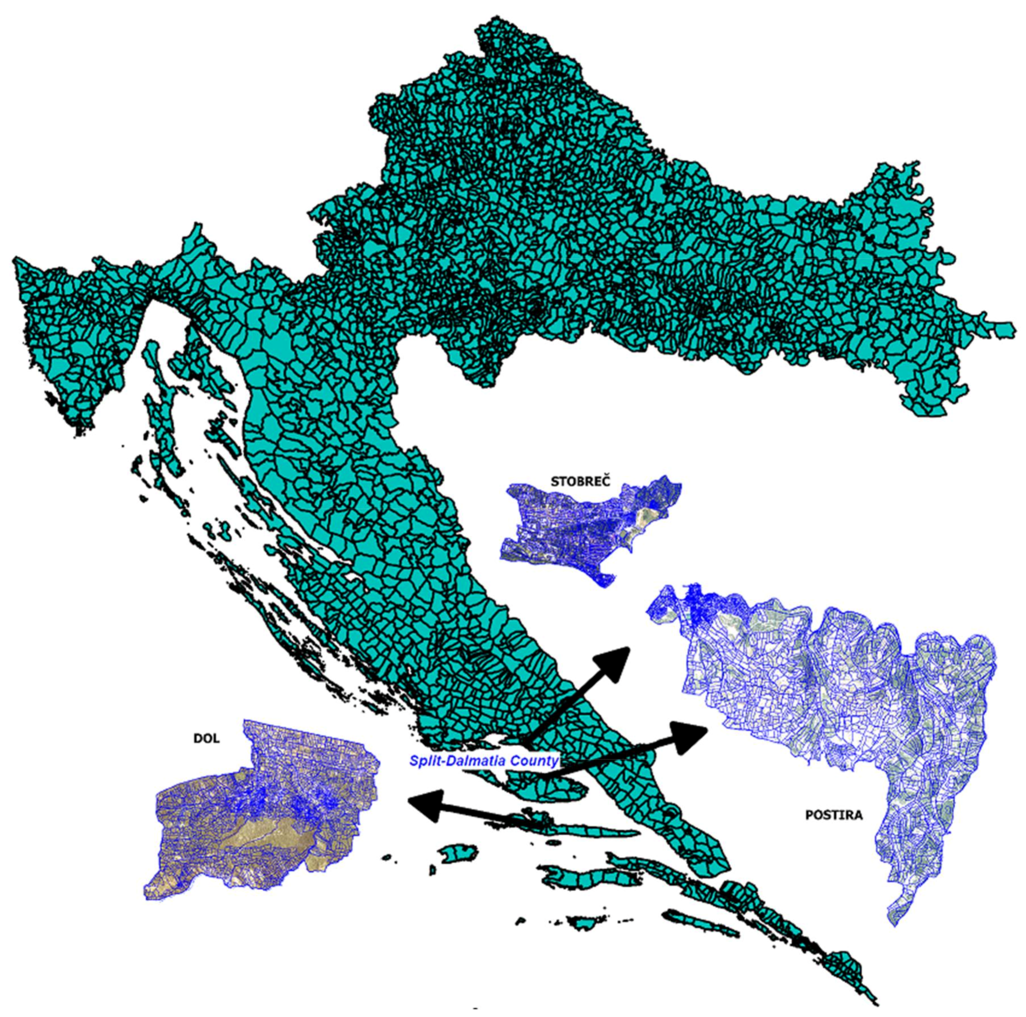
The research area included three cadastral municipalities, namely Dol, Postira, and Stobreč, covering an area of 1681 ha. They are in the Split–Dalmatia County (
Figure 2). Two cadastral municipalities, Dol and Postira, are located on the islands of Brač and Hvar, respectively, and Stobreč is on the mainland near the city of Split. Stobreč has a predominantly built-up area, while Dol and Postira are small settlements with predominant agricultural parcels. All the three cadastral municipalities are characterized by small parcels. The cadastral documentation has been produced at different political and technological circumstances. Dol and Postira are in the Franciscan cadastre, and Stobreč is in the socialist era.
General information and a summary of the quality control results for all the three cadastral municipalities are given in
Table 1. The general information includes name, ID, scale, and key cadastral years of each cadastral municipality. Furthermore, the individual results of quality control from vectorization projects are summarized for the entire research area. Although vectorization was conducted around 20 years ago, inconsistencies are still present in the cadastral documentation.
According to previous experiences, area differences are the best indicator of inconsistencies. Discovering the causes of these differences directly leads us to the way we can correct these inconsistencies. In many cases, when the error that caused the parcel area difference is corrected, the topological or thematic errors are also resolved. As the parcels whose area difference exceeds the tolerance are the subject of this analysis, the approach was conducted for 610 cadastral parcels, which is 4.59% of all the cadastral parcels recorded in all the three municipalities.
2.2.1. Dol
The cadastral municipality Dol is located on the island of Hvar, Croatia. The terrain is in a small part of the plains, and the other areas are slightly hilly (
Figure 2). The boundaries of the cadastral parcels are often dry-stone walls, which guarantees the reliability of the boundaries over time. The cadastral documentation was initially produced through the Franciscan cadastral survey. The cadastral surveying of the municipality was completed by the year of 1834. Dol was depicted by five cadastral map sheets at the scale of 1:2880, and one cadastral map sheet of the built-up areas had a scale of 1:1440. As the maintenance changes were conducted on the cadastral map, because of the illegibility of the map sheets, they were lithographed in the year 1894. The lithographed map sheets, after more than a hundred years of maintenance, were scanned and georeferenced and finally vectorized in 2009 [
36].
The cadastral municipality Dol has 5106 cadastral parcels recorded in the register with a total area of 505 ha and an average parcel area of 990 m
2. There are 73 parcels mapped in the cadastral map, which are not recorded in the register, and there are 110 cadastral parcels recorded in the register but not mapped in the cadastral map. Thirty parcels have duplicate ID numbers, and 19 are missing a parcel ID. Another inconsistency discovered by the quality control is the number of buildings not in the register, which is 207; there are 93 buildings recorded in the register but not mapped on the cadastral map (
Table 1). The most important result of the quality control for the cadastral municipality Dol is the number of parcels with area differences exceeding the tolerance of 20%, and there are 195 of them, which is 3.8% of all the cadastral parcels in the cadastral municipality. The data utilized for the analysis for the cadastral municipality Dol consisted of three scanned and georeferenced historical cadastral map sheets, cadastral map sheets, vectorized cadastral map, and the vectorization report, including the quality control results.
2.2.2. Postira
The cadastral municipality Postira is located on the island of Brač, Croatia. The land is very similar to the cadastral municipality of Dol, the lowlands by the sea, and the surrounding hills. There are also very small cadastral parcels in the settlement area, but the surrounding agricultural parcels are on average twice as large as in the cadastral municipality Dol (
Figure 2). The cadastral documentation was initially established during the Franciscan cadastre, and the graphical cadastral survey was completed by the year of 1834. The survey resulted in eight cadastral map sheets with a scale of 1:2880. The maintenance caused content overload, and the map sheets were lithographed in the year 1889. These lithographed map sheets remained in use until the vectorization in 2006 [
37].
The cadastral municipality Postira has 4556 cadastral parcels recorded in the register with a total area of 971 ha and an average parcel area of 2131 m
2 (
Table 1). There are 12 parcels mapped in the cadastral map that are not recorded in the register, and there are 38 cadastral parcels recorded in the register but not mapped in the cadastral map. There are no parcels with duplicate ID numbers, and two land pieces are missing the parcel ID. An additional inconsistency discovered by the quality control is the number of buildings not in the register, which is 87, while there are 46 buildings recorded in the register but not mapped in the cadastral map.
The most important result of the quality control for the cadastral municipality Postira is the number of parcels with area differences exceeding the tolerance of 20%, and there are 213 of them, which is 4.7% of all cadastral parcels in the cadastral municipality. The data used for the analysis for the cadastral municipality Postira consisted of six scanned and georeferenced historical cadastral map sheets, cadastral map sheets, vectorized cadastral map, and the vectorization report, which included the quality control results.
2.2.3. Stobreč
The cadastral municipality Stobreč is located near the city of Split in Croatia. The cadastral municipality is mainly a lowland area, mostly built as a suburb of the city of Split (
Figure 2). Initially, Stobreč was part of the cadastral municipality Kamen, which was established during the Franciscan cadastre. In the year 1976, the settlement of Stobreč was re-surveyed and established as an independent cadastral municipality. The method of survey was aerial photogrammetry, and the survey resulted in 15 cadastral map sheets having a scale of 1:1000 and one cadastral map sheet with a scale of 1:500 for the settlement. The cadastral map sheets from 1976 were maintained until 2007 when the cadastral municipality Stobreč was vectorized [
38].
The cadastral municipality Stobreč has 3622 cadastral parcels recorded in the register with a total area of 204,78 ha and an average parcel area of 565 m2. There are six parcels mapped in the cadastral map that are not recorded in the register, and there is one cadastral parcel recorded in the register but not mapped in the cadastral map. There are no parcels with duplicate ID numbers, and two land pieces are missing a parcel ID. Although originating from a more recent period, the inconsistency regarding the buildings was also discovered by the quality control. There are 36 buildings that are not recorded in the register, while there are 18 buildings recorded in the register but not mapped in the cadastral map. The most important result of the quality control for the cadastral municipality is the number of parcels with area differences exceeding the tolerance of 5%, and there are 202 of them, which is 5.6% of all the cadastral parcels in the cadastral municipality Stobreč. The data used for the analysis for the cadastral municipality Stobreč consisted of 16 scanned and georeferenced cadastral map sheets, a vectorized cadastral map, and the vectorization report, which included the quality control results.
The entire research area was characterized by relatively small cadastral parcels, averaging only 0.13 ha. The most common differences that indicated an inconsistency, areas exceeding tolerance, had approximately 5% of all the cadastral parcels. The cadastral municipalities individually were very close to the average.
2.3. Methodology
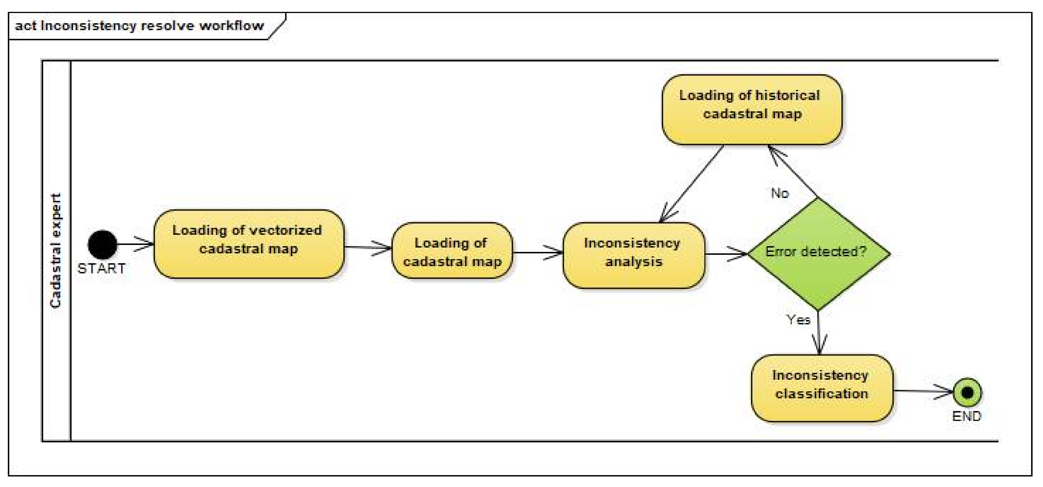
The analysis of inconsistencies is performed by a cadastral expert visually comparing data from different time series. The visual control was conducted using the GIS software (QGIS), which supports the use of raster and vector data, as the historical cadastral map sheets (raster) were overlapped with the vectorized cadastral map and further analyzed to determine the origin and the documentation of inconsistency. Each difference was individually analyzed by a visual comparison of the vectorized map and the state of the map being vectorized–paper-based cadastral map. If the correctness of the vectorized data was confirmed, the condition of the historical cadastral map was further compared. If the cause of the difference was not noticed here either, the comparison of register data was continued. Thus, the source of the difference and the time when it was generated were discovered (
Figure 3).
Visual control of inconsistency is performed by a cadastral expert utilizing data from different time series. The basis for the analyses is a vectorized cadastral map. In the first step, the cadastral map from which it is vectorized is loaded in background. The cadastral expert controls whether the determination of coordinates in vectorization is done correctly and whether the parcel ID is correctly read and entered on the vectorized cadastral map. If any of this is wrong, the expert completes the analysis, classifies the inconsistency, and corrects the error that caused the inconsistency. If everything is correct, the expert loads the historical cadastral map and analyzes whether an error was made when lithographing that map. Historical cadastral maps, if there are more than one, are analyzed sequentially backwards all the way to the oldest map. If the source of the inconsistency is not discovered, all maintenance and restoration work is done correctly, it means that the cause is in the cadastral survey.
All the inconsistencies were classified into four main sources. These were activities that were accomplished within the initial cadastral survey, lithography, vectorization, and maintenance. Criteria for classification into these main sources are derived from the process of establishment, documentation renewal, and maintenance of a cadastre. This classification includes all tasks where there was a possibility of making an error. As each of these processes occurred during different time periods, we noted when the inconsistency occurred as the years of initial surveys, lithography, vectorization, and last maintenance that were known using a joint information system [
39]. Note that the date of last maintenance for some cadastral parcels was not provided, and these were marked as unknown. Moreover, the cadastral document where the error caused inconsistency was detected, and whether it was in the register or the cadastral map was identified. Both the datasets were compared because they could be associated by using the parcel ID. As the quality of analyzing the differences is dependent on experience of cadastral expert, recorded is also the personal assessment of confidence of analyzed cases, whether the expert was certain or uncertain in his/her assessment. To estimate the time required for such an analysis, the duration for solving each cadastral parcel inconsistency was also recorded.
3. Analysis and Results
In this research, all the inconsistencies indicated by the area differences exceeding the tolerances were analyzed and resolved. All the 610 cadastral parcels from three cadastral municipalities of the research area, reported in the vectorization reports, were carefully investigated. The time for each inconsistency investigation was also recorded. The analysis of each of the 604 inconsistencies lasted less than 10 min, and the analysis of only six more than 10 min. The average time for solving each inconsistency was around 5 min. As this methodology was dependent on the experience and knowledge of the cadastral expert conducting the analysis, the certainty of each analyzed inconsistency was also noted. There were 565 certain analyses rated by experts, and 45 were rated as uncertain mainly because of the poor readability of the cadastral map sheets. These uncertain cases need to be investigated in further detail and the findings confirmed with the help of additional documentation.
The analyzed area inconsistencies were classified by their inconsistency origin and source. The typical origins of the inconsistencies were classified by the processes used in the analyzed cadastral municipalities since their establishment: cadastral survey, lithography in case the cadastral map was lithographed, vectorization, and the maintenance. The classification was limited to four basic sources that represented the distinct subprocesses in the life cycle of the cadastral documentation establishment, maintenance, and renewal. It was important to have the metadata information of each cadastral municipality, as a process such as lithography was only conducted for the cadastral municipalities originating from the Franciscan cadastre.
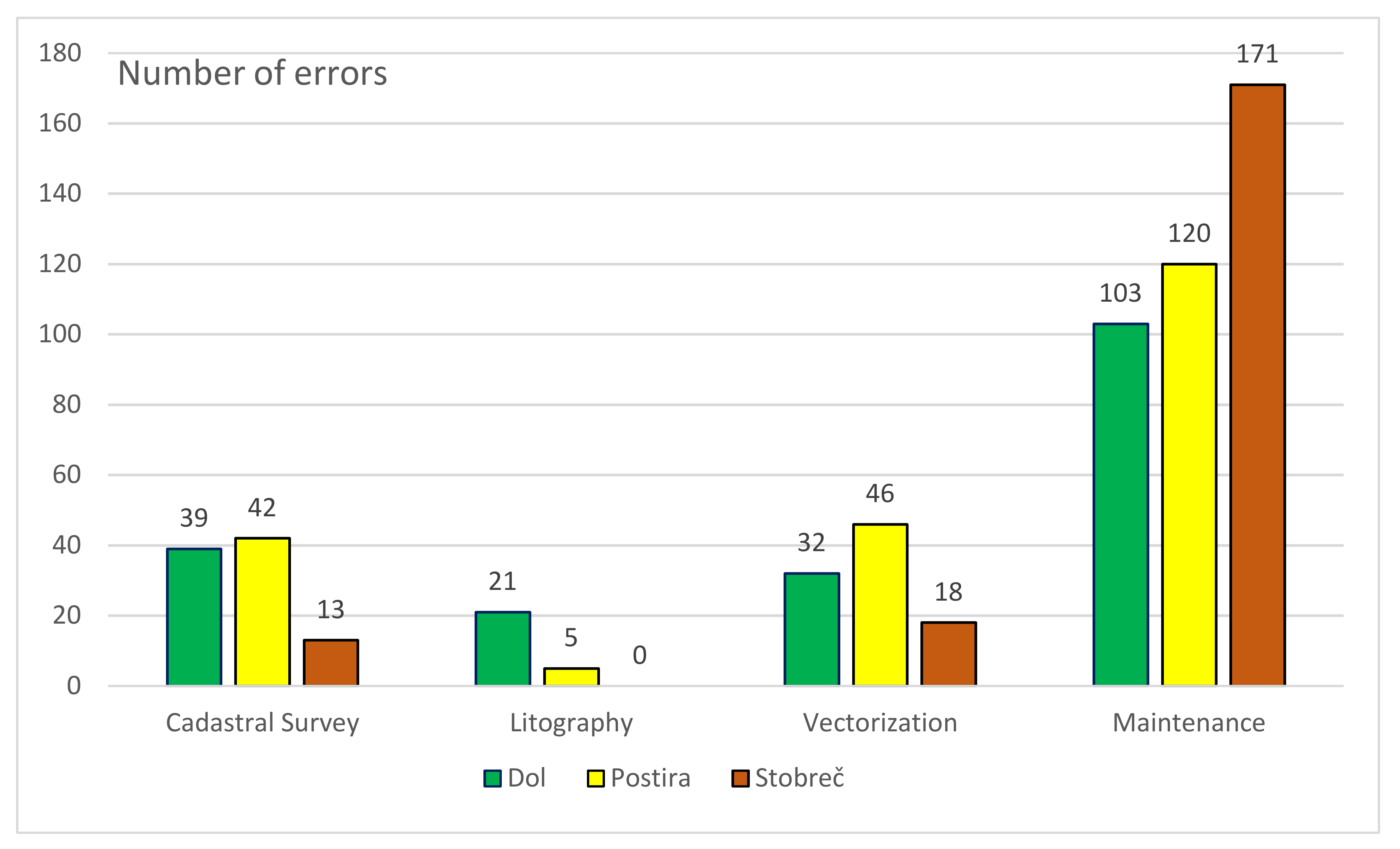
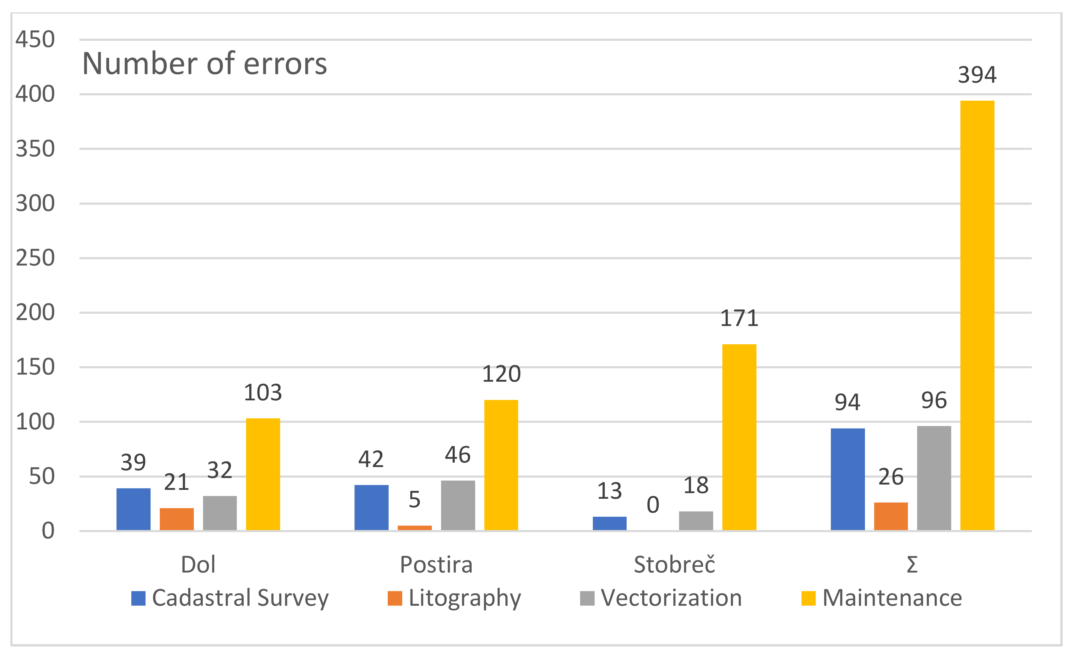
Thus far, the least errors were made during lithography and the most during maintenance (
Figure 4). A significant number of errors, in all the three cadastral municipalities, were the remaining vectorization errors. These errors should not have been present because the vectorization contractor should have corrected them as part of the vectorization project.
The maximum inconsistencies caused by the cadastral survey were in the cadastral municipality Postira, but the results were very similar for the cadastral municipality Dol as well. Stobreč had only 13 inconsistencies caused by the cadastral survey, but as the cadastral survey of Stobreč was conducted with superior equipment and methodology, it could be stated that these results were expected. As the cadastral map sheets of cadastral municipality Stobreč were not lithographed, there were no lithography-caused inconsistencies in Stobreč, hence the emphasis on knowing the year of establishment of the cadastral municipality and the other metadata. Most of the lithography-caused inconsistencies were found in Dol.
Vectorization-caused inconsistencies might be the most concerning, as these had to be addressed before the approval of the vectorized cadastral map. The vectorization-caused inconsistency results for the cadastral municipalities Dol and Postira were somewhat similar (32 for Dol and 46 for Postira), while Stobreč had 18 vectorization-caused inconsistencies. Most of the inconsistencies examined in this study originated from the cadastral data maintenance. Note that the process of maintenance was the longest-occurring process in the cadastral municipalities, as some of them were established in the 19th century and maintained since then. Most of the inconsistencies caused by the maintenance were in cadastral municipality Stobreč, resulting in 171 out of the 202 examined cadastral parcels. Dol and Postira had 103 and 120 inconsistencies caused by the maintenance.
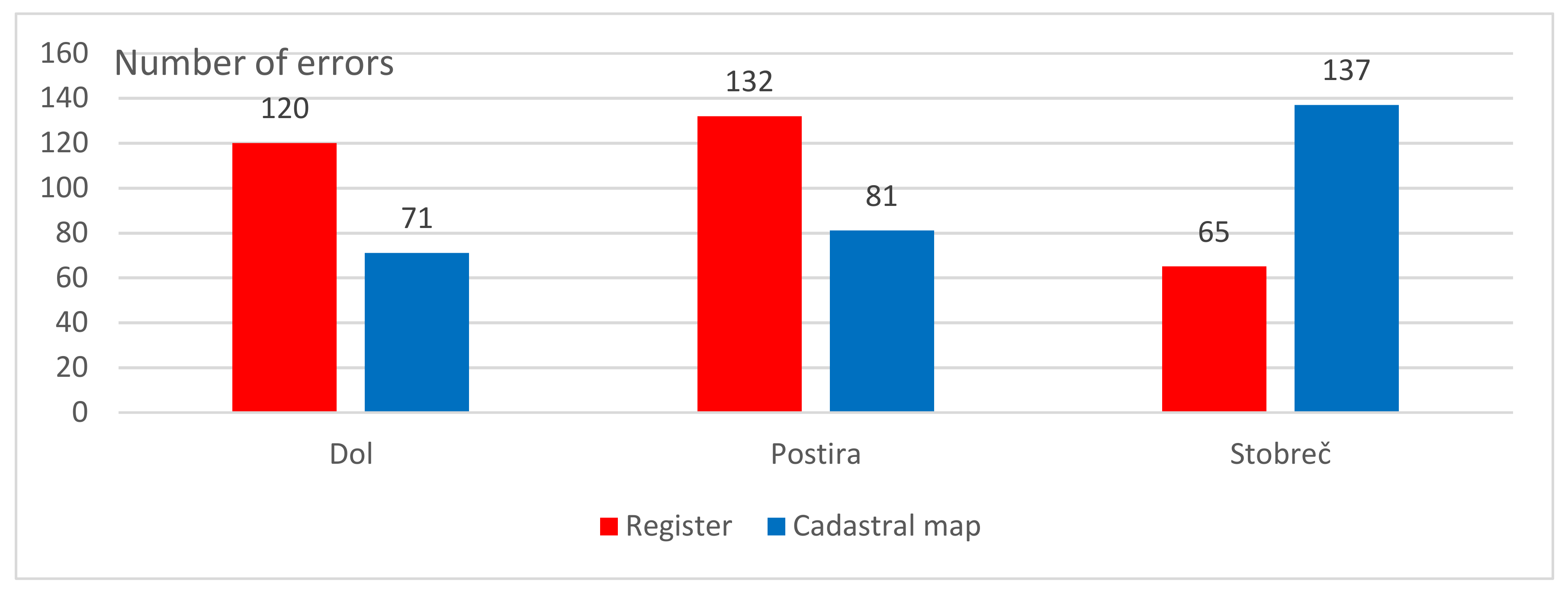
We also determined whether the inconsistency originated from the register or from the cadastral map. The evaluation results for the document of inconsistency are shown in
Figure 5 for each cadastral municipality. The cadastral municipalities Dol and Postira had somewhat similar results in terms of the determined document of area inconsistency with the most inconsistencies in the register. The results for the cadastral municipality Stobreč were quite the opposite and resulted in more inconsistencies in the cadastral map.
Knowing the document where the area inconsistency was could be very helpful in the correction process.
There are numerous types of errors that can cause an inconsistency. These are errors in determining the areas on the cadastral map, coordinates in vectorization, omitted parcel IDs or boundaries in lithography, misread parcel IDs, etc. A common cause of errors is a cadastral map damaged by long-term use. In the following subsections, examples for each inconsistency origin are illustrated and described. The content of the vectorized cadastral map is shown in blue, and the background is the corresponding raster sheet of the cadastral map. The images are in the approximate scale indicated on each of them. The cadastral particles to which the inconsistency refers are underlined in green. The result of the examination is given and explained.
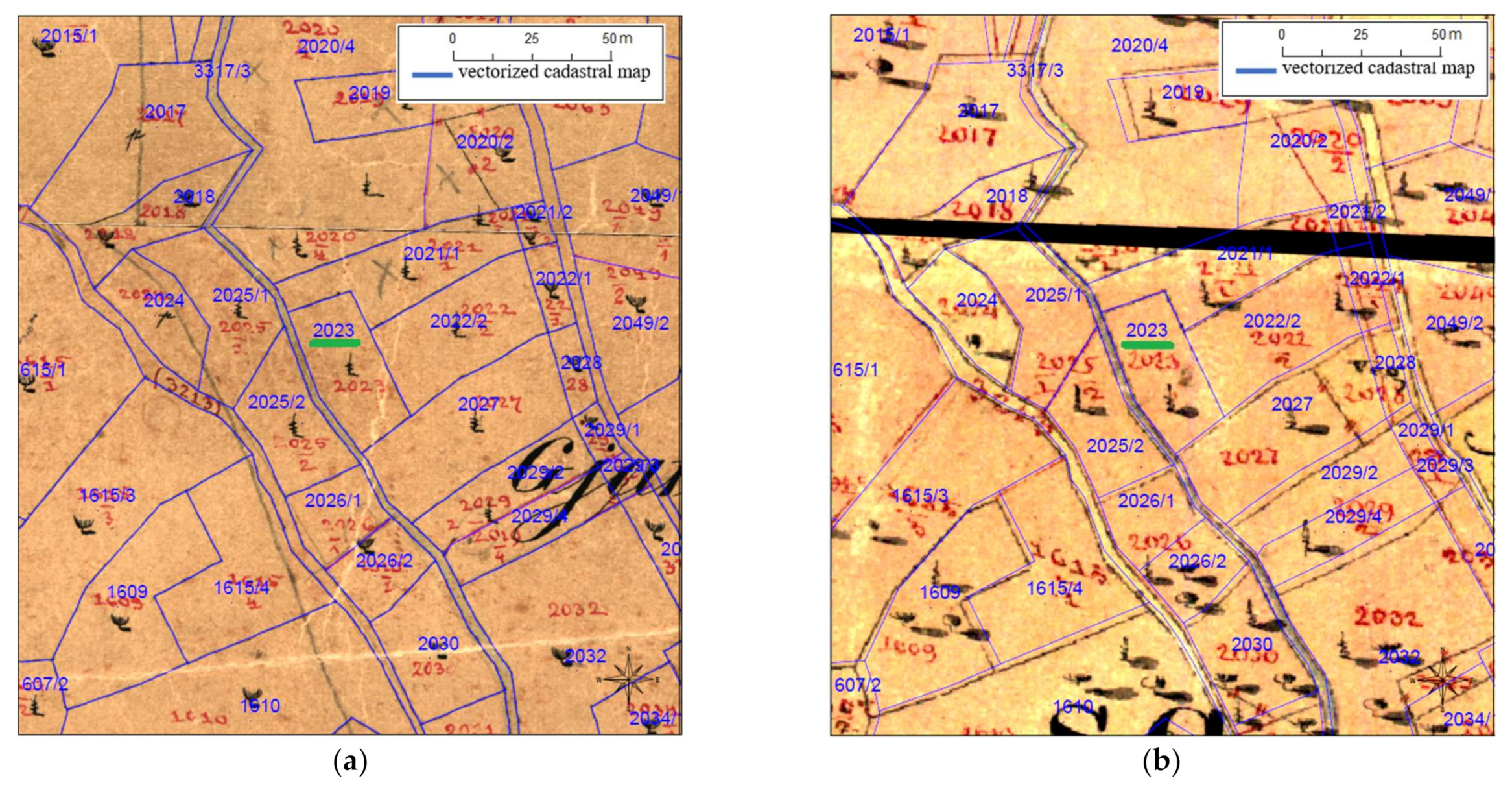
3.1. Cadastral Survey
Most of the area inconsistencies caused by the cadastral survey were determined in the cadastral municipality Dol, 39 out of 195 analyzed cadastral parcels, which was 20% of all the area inconsistencies. An example of an inconsistency caused by the cadastral survey can be explained on cadastral parcel 2023. The vectorization quality control report states that the registered area is 424 m2, and the area calculated from the vectorized cadastral map is 807 m2. The calculated difference is 383 m2, 341 m2 (80%) of which exceeds the allowed tolerance.
Checking the quality of the vectorization (
Figure 6a) indicates that the coordinates of the breakpoints of the boundaries are well determined. Furthermore, checking the state on the historical cadastral map (
Figure 6b) from which the cadastral map sheet was copied also indicates that the vectorized map is correct. This indicates that the error was made earlier. The integer parcel ID indicates that there were no changes on the cadastral parcel, which leads us to the conclusion that the error was made in the cadastral survey.
The origin of the inconsistency is the cadastral survey, and because the area on the cadastral map corresponds to the area on the vectorized cadastral map, we conclude that the registered area is invalid and that the document of the inconsistency is the register. The year of inconsistency was the year of the cadastral survey (1834).
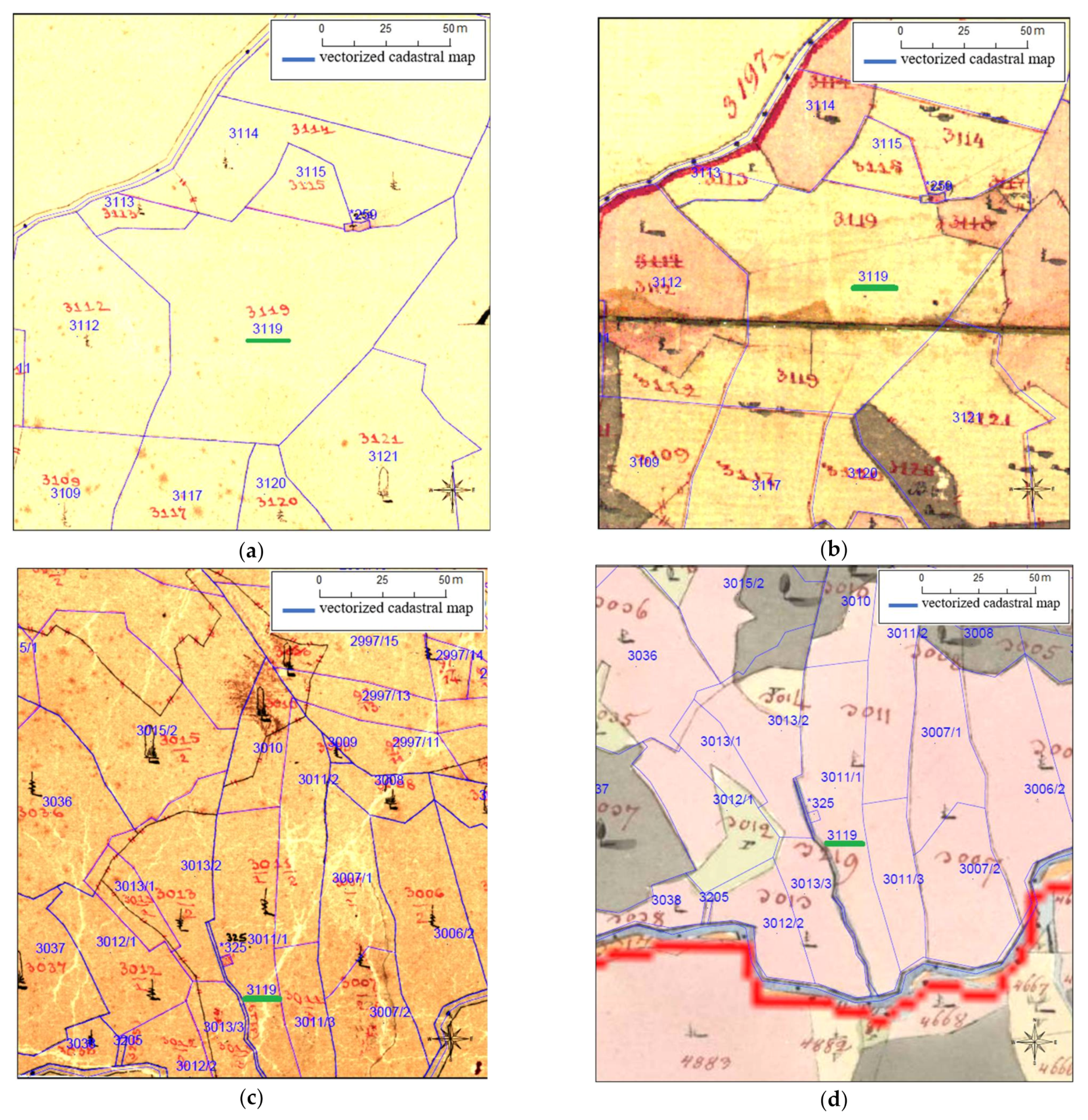
3.2. Lithography
Lithography is the process of renewing the cadastral map sheets because of their illegibility, as the maintenance changes were conducted on the cadastral map. There were 26 lithography-caused inconsistencies in the 610 analyzed cadastral parcels. Most of the lithography-caused errors were in Dol, 21 out of 26. An example of a lithography-caused inconsistency is cadastral parcel 3119 from the cadastral municipality Dol (
Figure 7). There were two cadastral parcels on the cadastral map with the same parcel ID 3119. The inconsistency was caused by the lithography, as there were also two same numbers in the paper cadastral map but at different positions.
The register area for the cadastral parcel 3119 was 7646 m2, and the area calculated from the cadastral map was 106 m2. The calculated area difference was 7540 m2 with an allowed tolerance of 176 m2. That is, it passed for 7364 m2 (96%). The origin of the inconsistency was lithography, as the wrong number was set in the wrong place during the lithography of the map. The document of the inconsistency was the cadastral map, and the responsibility for the correction lay in the domain of the cadastral authority. The examination result was marked as certain. The year of inconsistency was the year of lithography, i.e., 1894.
One occurrence of ID 3119 was assigned to a larger cadastral parcel, as shown in
Figure 7a, and the other to a narrow and long cadastral parcel in another position (
Figure 7c). If we overlap the vectorized cadastral map, position 1 with the historical cadastral map (
Figure 7b), we see that the parcel ID is correctly assigned to that cadastral parcel. If we do the same at position 2, we observe that on the historical cadastral map, the narrow and elongated cadastral parcel had parcel ID 3219. This indicates that an error was made when entering the parcel IDs during the lithography.
3.3. Vectorization
The area inconsistencies caused by the vectorization were 96 out of 610. Vectorization was carried out manually, so the inconsistencies caused by human error were expected. Most of the vectorization-caused inconsistencies were found in the cadastral municipality Postira, resulting in 46 out of the 96 vectorization-caused inconsistencies, or at the municipality level, 46 out of 213, which was around 21% of all the area inconsistencies.
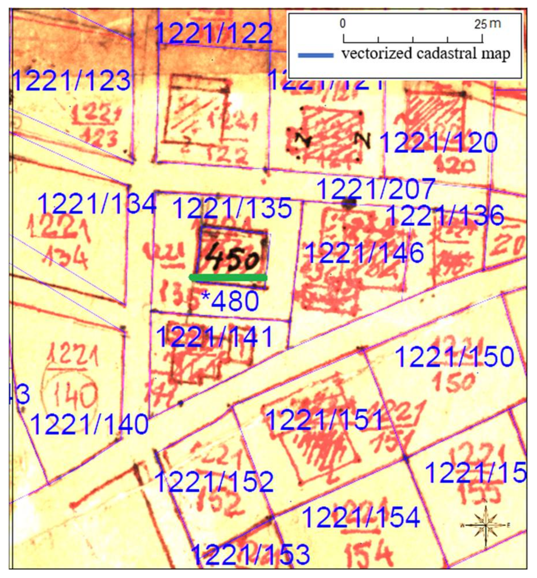
An example of the vectorization-caused inconsistencies is the cadastral parcel ID *480 from Stobreč, where the “*” represents the mark for the built-up cadastral parcels (
Figure 8). The register area for the cadastral parcel *480 was 80 m
2, and the area calculated from the cadastral map was 122 m
2. The tolerated area difference was 18 m
2, and the calculated difference was 42 m
2. The final difference was 24 m
2, which was 30%. The vectorization-caused inconsistency was obvious in this example, as the built cadastral parcel in the cadastral map had ID 450 but was vectorized as *480.
As this cadastral parcel was vectorized improperly in terms of the cadastral parcel ID determination, these results in the report were completely wrong and the cadastral parcel 450 was missing from the cadastral map. The document of the inconsistency was the cadastral map, the inconsistency analysis was certain.
3.4. Maintenance
Ever since the establishment of the cadastre, it had to be maintained to represent the actual situation of the land features. The methodology for the maintenance was defined by the law, and although the political and technological circumstances have changed over time, the principle of maintenance has remained almost the same. Before the digitization of the register and the cadastral map, the maintenance changes were conducted on the map and then in the register. Out of the 610 analyzed area inconsistencies, 394, or around 64%, were the results of maintenance. In all the three analyzed cadastral municipalities, the maintenance-caused area inconsistencies were the maximum, but in the cadastral municipality Stobreč, this number was the highest, where around 85% of the analyzed area inconsistencies were caused by the maintenance of the cadastral data.
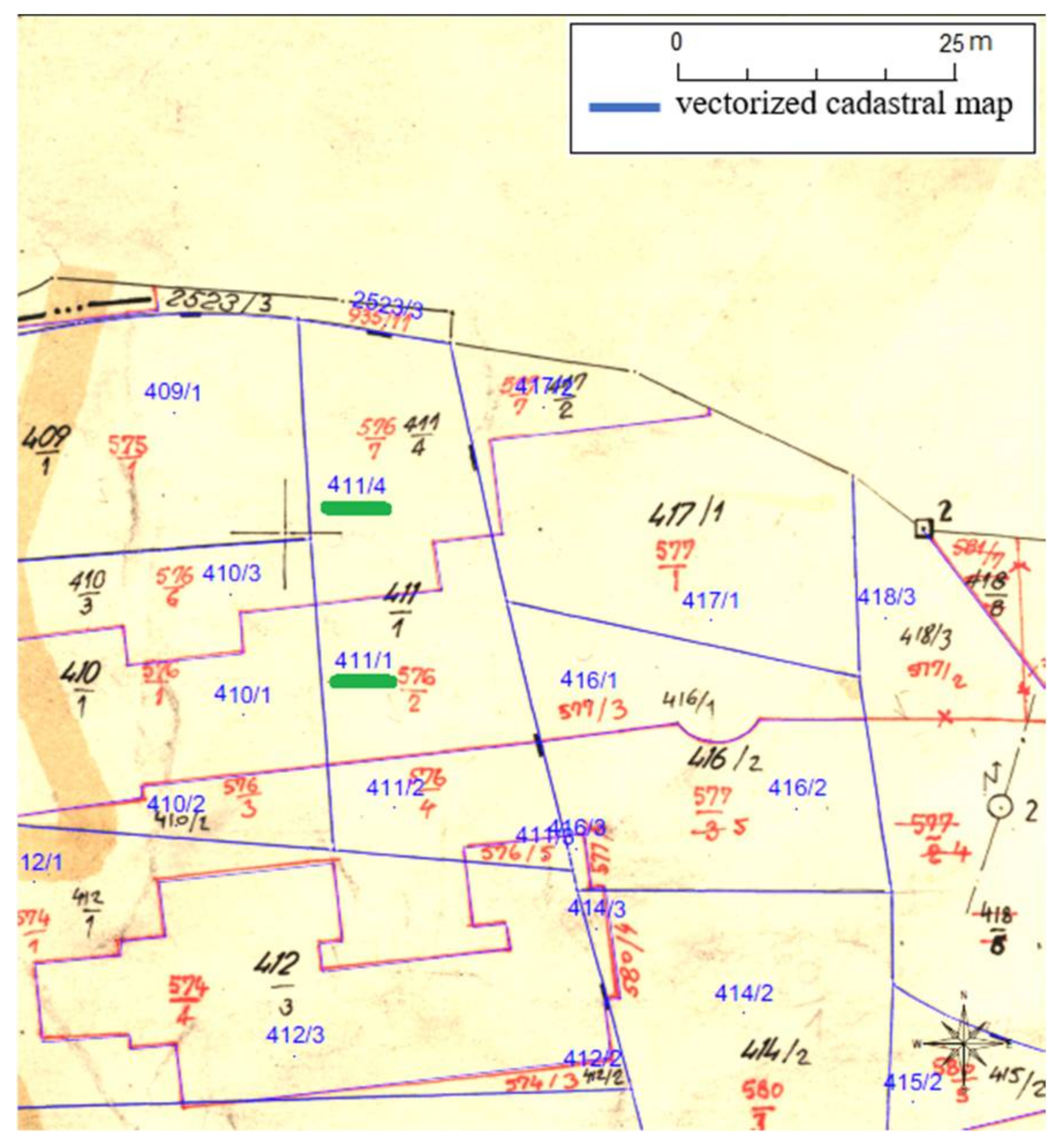
An example of a maintenance-caused area inconsistency for cadastral parcels 411/1 and 411/4 in the cadastral municipality Stobreč, which were established after the subdivision of cadastral parcel 411 is shown in
Figure 9. The register area of cadastral parcel 411/1 was 333 m
2, and the area calculated from the cadastral map was 283 m
2, while the register area of the cadastral parcel 411/4 was 280 m
2, and the calculated area was 333 m
2. Both were marked as parcels with an area inconsistency, where the inconsistency for cadastral parcel 411/1 was 11% and that for cadastral parcel 411/4 was 15%.
This inconsistency was undoubtedly caused by the cadastral officer responsible for the registration of the subdivision in the register. The area values were misplaced in the register, which led the contractor of vectorization to mark these cadastral parcels as parcels with an area inconsistency. The document of the inconsistency was the register, and the responsibility for the correction lay in the domain of the cadastral authority. The analyzed result was marked as certain. This example is also specific because it raises the need to analyze not only the sole cadastral parcel with an inconsistency but also the cadastral parcels surrounding it to be certain of what might have caused the area inconsistency.
4. Discussion
The research focused on a cadastral data inconsistency generated through many years of separate management of the cadastral map and register. Within the vectorization project, inconsistencies were discovered and documented. A detailed analysis of each individual inconsistency showed that the inconsistencies were caused not only by maintenance errors but also by other processes such as the initial cadastral surveying, lithography, and vectorization (
Figure 10).
The processes took place during various periods of time, some even 200 years ago, and it was necessary to use documentation from that time to discover the causes of inconsistencies. This documentation is often in the archives and is limited in availability. However, as it is a matter of the legal security of land data, an effort has been made to collect it. As can be seen from the examples, many inconsistencies would remain unresolved without the use of these data.
The cadastral municipalities Dol and Postira were established during the same period, the Franciscan cadastre, and according to the results of the analysis were somewhat correlated. The results of the area inconsistency origins and documents were similar, indicating that there were more inconsistencies in the register than in the cadastral map. These cadastral municipalities were affected by more processes (for example, the lithography) than the cadastral municipality Stobreč and have been maintained for a longer period. Although the cadastral municipality Stobreč was established years later than Dol and Postira, the analysis results indicated that the cadastral maintenance, particularly of the cadastral map, was of a considerably lower quality than the maintenance in cadastral municipalities originating from the Franciscan cadastre. This statement can also be viewed relatively, as the tolerances for the newer cadastral surveys are lower.
Although up to 10 min was generally sufficient to detect the cause of an individual difference, better availability, particularly of the archived data, would speed up the inconsistency correction process. This issue could have been solved if the data were available via web services such as a web feature or a web mapping service. The other issue that might be critical was the lack of metadata. Knowledge regarding the processes and time when they occurred was of considerable assistance in resolving inconsistencies. The scale of the cadastral map was crucial information, as the tolerances for the area differences stipulated by law depended on it.
The final issue that may occur from this process is the question of how to correct these inconsistencies. The methodology proposed a cadastral authority, or in the case of vectorization-caused inconsistencies, the contractor of vectorization, to take responsibility for the corrections. In some cases, it was marked as unknown for who should take the responsibility for the corrections.
Correcting the inconsistencies may give rise to the following questions:
As the cadastral data are in the domain of the cadastral authority, should they correct the mistakes without notifying the stakeholders of the corrections?
What if the stakeholders notice the inconsistency and hire geodetic experts to correct them? If yes, who should take care of the costs of such a procedure?
Is there any responsibility for the contractor of vectorization as the independent control and authentication is supposed to be conducted before the approval of the vectorized cadastral map?
As these are inconsistencies that are the result of errors in the work of the competent authorities, as a rule, the regulations stipulate that such errors should be corrected “ex officio.” It will address the inconsistencies in a timely and efficient manner. This will avoid lengthy and complex administrative cadastral procedures.
As the number of inconsistencies identified in the vectorization projects for around 3300 cadastral municipalities in Croatia is significant, their correction has not generally been carried out systematically. As a rule, they are corrected within the registration of the reported change on the cadastral parcel in question. Thus far, the correction of inconsistencies will take a very long time, and in this period, the trust in the cadastre will not be at a satisfactory level. This approach demonstrates that each cadastral municipality can be examined, and its inconsistencies resolved relatively quickly (15–20 working hours). With such a relatively small investment in the authoritative data reliability, trust in the cadastre will be significantly improved.
The best way to reach better cadastral data quality and achieve full integrity will be cadastral resurveys. However, they are expensive and very often time consuming. Those implemented in Croatia since 2000 have ensured the renewal of only approximately 5% of the cadastral documentation [
40]. Therefore, correcting inconsistencies in the existing data is necessary to ensure the daily needs of users by the time all the data are restored by the cadastral resurveys.
5. Summary and Conclusions
Addressing the inconsistencies in the cadastral data is of utmost importance as the data are utilized by many other professionals. If there are many inconsistencies in the cadastral datasets, the data cannot be deemed as reliable and may cause further inconsistencies as the cadastral data are used to derive other land-related information such as rights, restrictions, and responsibilities. Based on the results of the quality control of the vectorization projects, the inconsistencies of cadastral data for three cadastral municipalities were analyzed. The inconsistencies for cadastral parcels were classified and resolved according to the proposed methodology within a reasonable time. The methodology and achieved results indicated that cadastral data inconsistencies could be classified and resolved successfully and quickly. A systematic correction of inconsistencies with the proposed methodology would significantly increase the quality and integrity of the registered data in the cadastre.
The research showed that the worst task in the cadastre was maintenance. More errors were made in maintenance than in all other tasks in total. There are approximately equal errors in cadastral survey and vectorization tasks. The least mistakes were made in restoration of map sheets by lithography at the turn of the 19th and 20th centuries. Therefore, it can be concluded that computer processing does not guarantee quality if it is not done professionally and conscientiously.
These results indicated that similar outcomes could be achieved if the methodology were tested on more cadastral municipalities. However, prior to any analysis, the metadata information of cadastral datasets is necessary to determine the criterion of the analysis. The next step in enhancing this process would be to improve the cadastral data and metadata availability. This will further facilitate and accelerate activities to resolve inconsistencies in cadastral documentation to achieve the cadastral data integrity.


