Assessing Interactions between Agriculture, Livestock Grazing and Wildlife Conservation Land Uses: A Historical Example from East Africa


Abstract
:1. Introduction
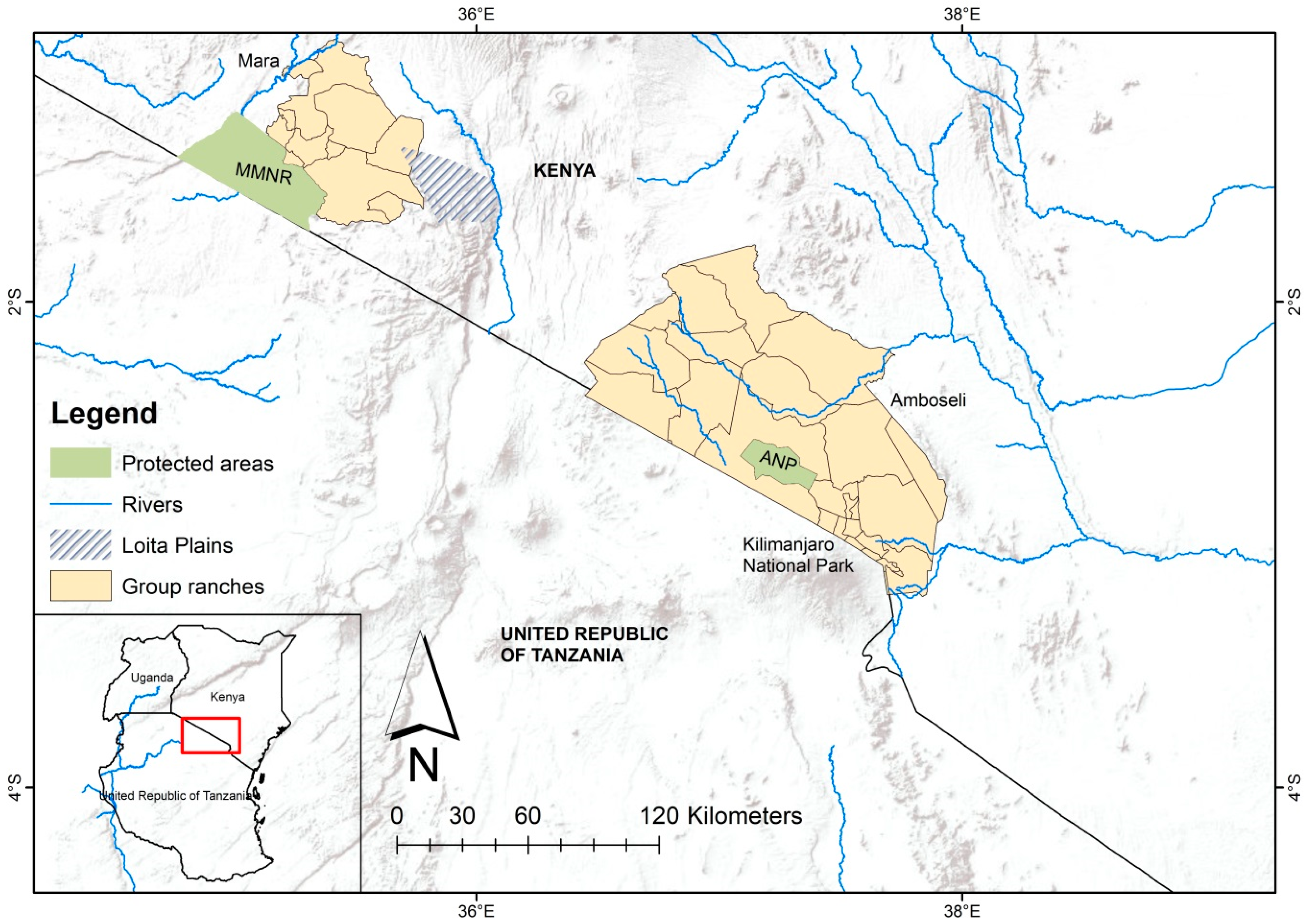
2. Study Areas
3. Methods
3.1. Ethics Statement
3.2. Data Collection
4. Results
4.1. Changes in Livestock Grazing, Agriculture, and Wildlife Conservation over Time
4.2. Drivers of Land Use Change
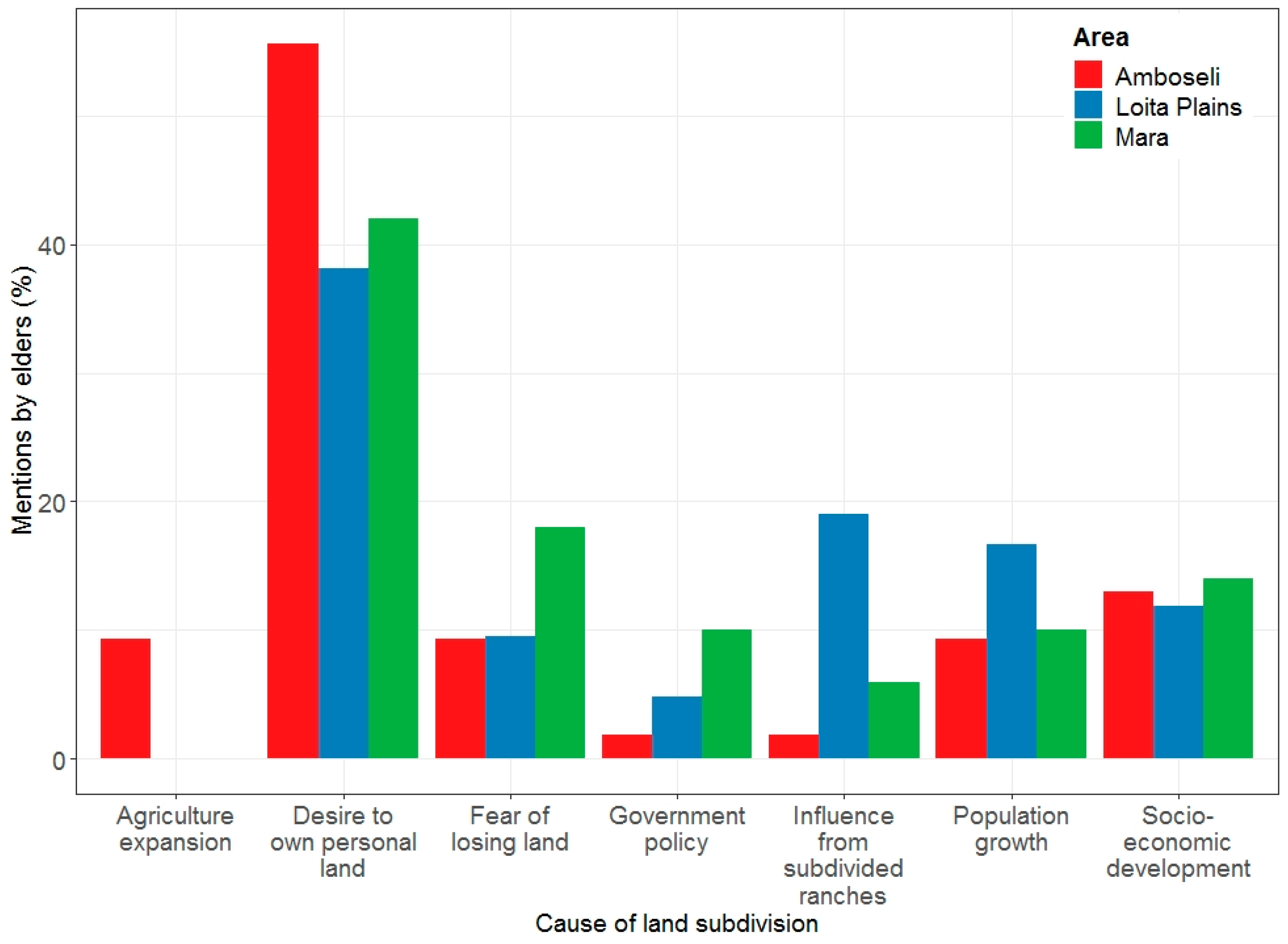
4.3. Drivers of Land Subdivision
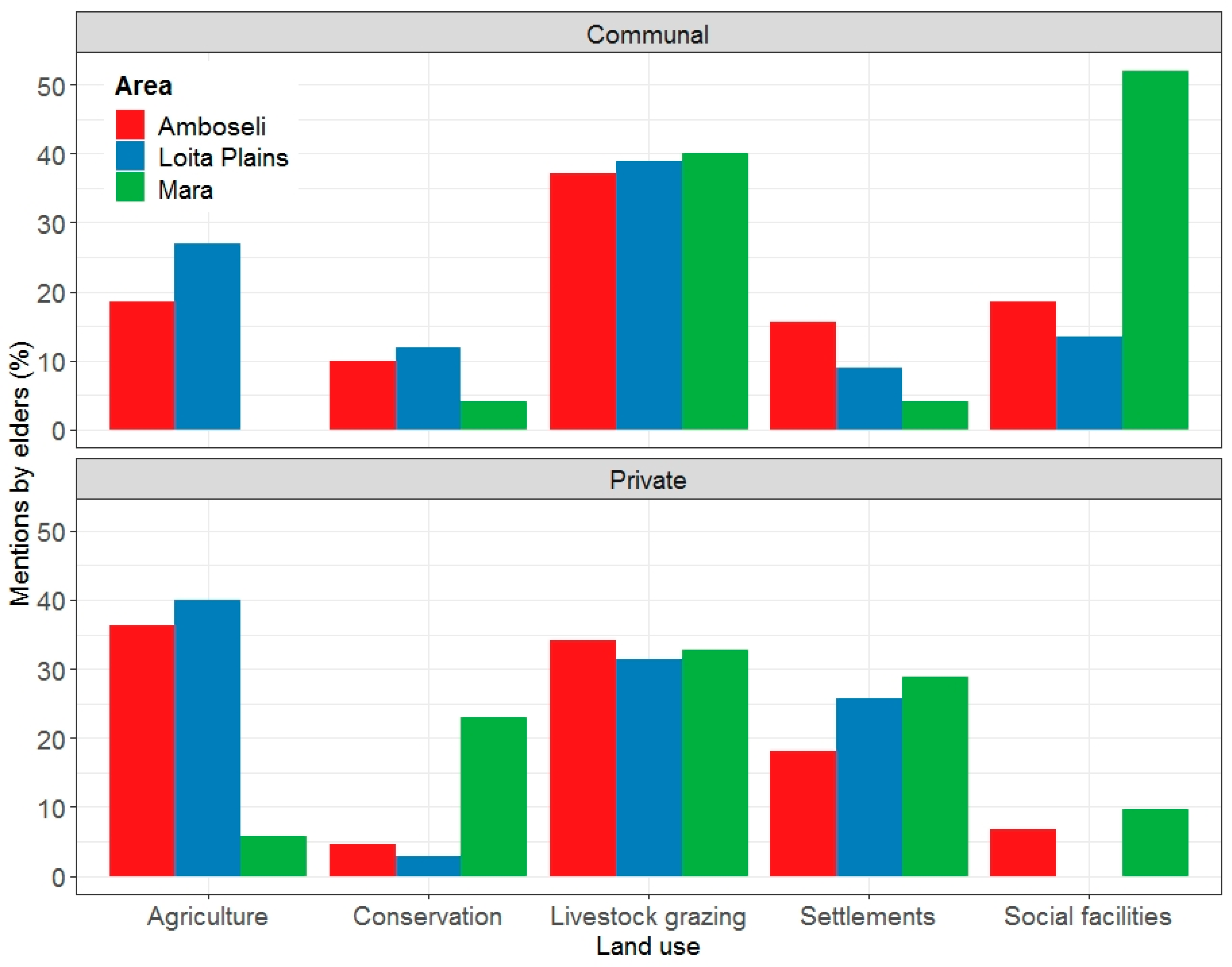
4.4. Changes in Land Use Types in Relation to Land Tenure Type
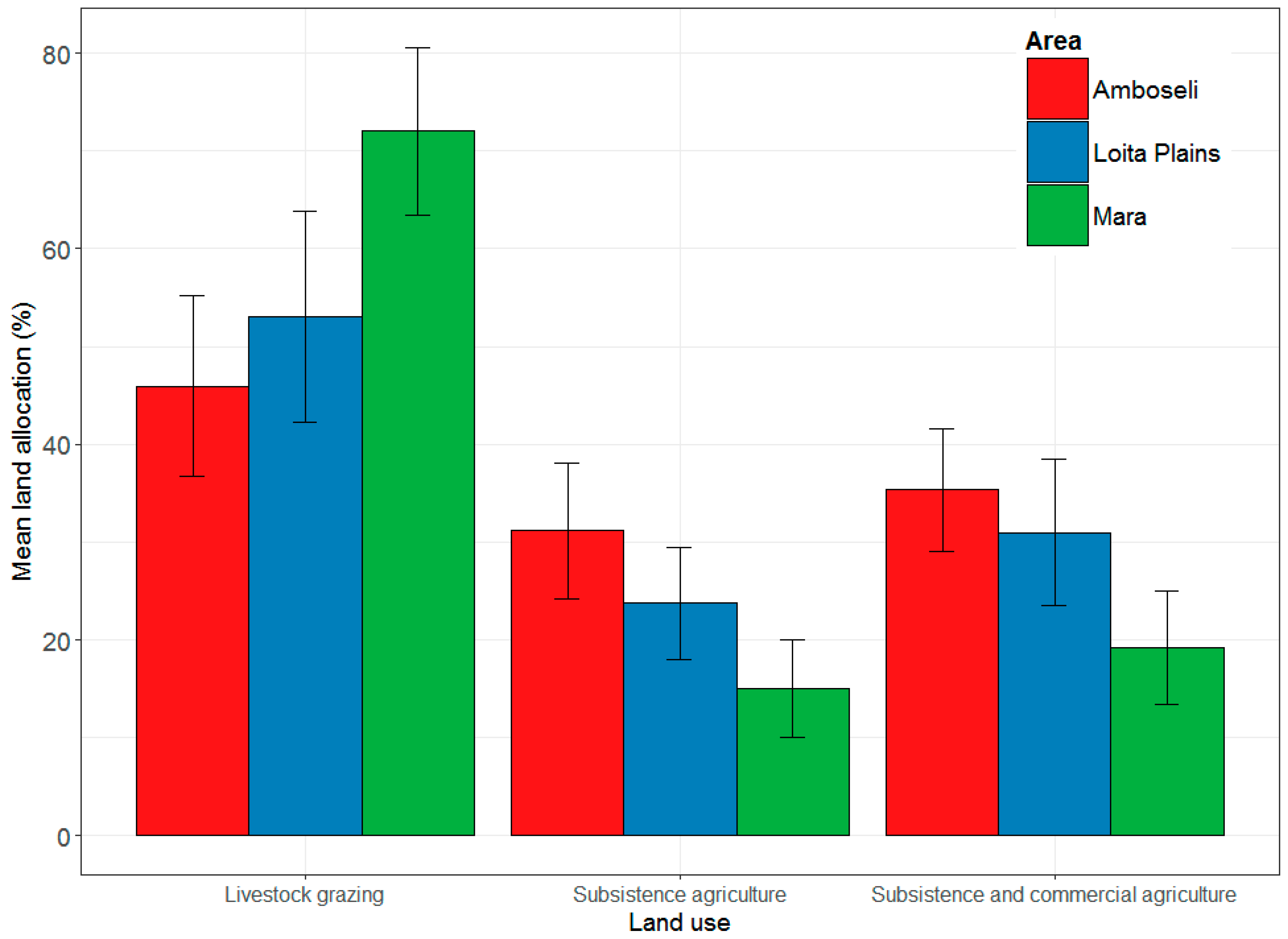
4.5. Allocation of Private Land to Livestock Grazing and Agricultural Land Uses
5. Discussion
5.1. Pastoralism, Wildlife Conservation and Agriculture
5.2. Drivers of Land Use Change and Land Subdivision
5.3. Implications of Sedentarization on Livestock Grazing and Wildlife Conservation
6. Conclusions
Supplementary Materials
Author Contributions
Funding
Institutional Review Board Statement
Informed Consent Statement
Data Availability Statement
Acknowledgments
Conflicts of Interest
References
- Mirzabaev, A.; Ahmed, M.; Werner, J.; Pender, J.; Louhaichi, M. Rangelands of Central Asia: Challenges and opportunities. J. Arid. Land. 2016, 8, 93–108. [Google Scholar] [CrossRef] [Green Version]
- Reid, R.S.; Fernández-Giménez, M.E.; Galvin, K.A. Dynamics and resilience of rangelands and pastoral peoples around the globe. Annu. Rev. Environ. Resour. 2014, 39, 217–242. [Google Scholar] [CrossRef]
- Western, D.; Tyrrell, P.; Brehony, P.; Russell, S.; Western, G.; Kamanga, J. Conservation from the inside-out: Winning space and a place for wildlife in working landscapes. People Nat. 2020, 2, 279–291. [Google Scholar] [CrossRef] [Green Version]
- Kirkbride, M.; Grahn, R. Survival of the fittest: Pastoralism and climate change in East Africa. Oxfam. Policy. Pract. Agric. Food Land 2008, 8, 174–220. [Google Scholar]
- Groom, R.J.; Western, D. Impact of land subdivision and sedentarization on wildlife in Kenya’s southern rangelands. Rangel. Ecol. Manag. 2013, 66, 1–9. [Google Scholar] [CrossRef]
- REGLAP. Key Statistics on the Drylands of Kenya, Uganda and Ethiopia, REGLAP Secretariat; Regional Learning and Advocacy Program for Vulnerable Dryland Communities: Nairobi, Kenya, 2012. [Google Scholar]
- UNCCD; World-Bank. Land for Life. Create Wealth, Transform Lives; UNCCD Secretariat: Bonn, Germany; Washington, DC, USA, 2016. [Google Scholar]
- Reid, R.S.; Nkedianye, D.; Said, M.Y.; Kaelo, D.; Neselle, M.; Makui, O.; Onetu, L.; Kiruswa, S.; Kamuaro, N.O.; Kristjanson, P.; et al. Evolution of models to support community and policy action with science: Balancing pastoral livelihoods and wildlife conservation in savannas of East Africa. Proc. Natl. Acad. Sci. USA 2016, 113, 4579–4584. [Google Scholar] [CrossRef] [Green Version]
- Kiffner, C.; Wenner, C.; LaViolet, A.; Yeh, K.; Kioko, J. From savannah to farmland: Effects of land-use on mammal communities in the Tarangire–Manyara ecosystem, Tanzania. Afr. J. Ecol. 2015, 53, 156–166. [Google Scholar] [CrossRef]
- Homewood, K.M.; Rodgers, W.A. Maasailand Ecology: Pastoralist Development and Wildlife Conservation in Ngorongoro, Tanzania; Cambridge University Press: Cambridge, UK, 2004. [Google Scholar]
- Liao, C.; Barrett, C.B.; Kassam, K.A. Does Diversification Translate into Improved Livelihoods? Evidence from Pastoral Households in the Altay and Tianshan Mountains of Xinjiang, China? Evidence from Pastoral Households in the Altay and Tianshan Mountains of Xinjiang, China. 2014. Available online: https://ssrn.com/abstract=2628701; http://dx.doi.org/10.2139/ssrn.2628701 (accessed on 20 October 2020).
- Worden, J.S. Fragmentation and Settlement Pattern in Maasailand: Implications for Pastoral Mobility, Drought Vulnerability, and Wildlife Conservation in an East African Savanna. Ph.D. Thesis, Colorado State University, Fort Collins, CO, USA, 2007. [Google Scholar]
- Devereux, S. Better marginalised than incorporated? Pastoralist livelihoods in Somali Region, Ethiopia. Eur. J. Dev. Res. 2010, 22, 678–695. [Google Scholar] [CrossRef]
- Homewood, K.; Kristjanson, P.; Trench, P. (Eds.) Staying Maasai? Livelihoods, Conservation and Development in East African RangeLands (Vol. 5); Springer Science & Business Media: New York, NY, USA, 2009. [Google Scholar]
- Marchant, R.; Richer, S.; Boles, O.; Capitani, C.; Courtney-Mustaphi, C.J.; Lane, P.; Prendergast, M.E.; Stump, D.; De Cort, G.; Kaplan, J.O.; et al. Drivers and trajectories of land cover change in East Africa: Human and environmental interactions from 6000years ago to present. Earth Sci. Rev. 2018, 178, 322–378. [Google Scholar] [CrossRef]
- Marshall, F.; Hildebrand, E. Cattle before crops: The beginnings of food production in Africa. J. World. Prehist. 2002, 16, 99–143. [Google Scholar]
- Lankester, F.; Davis, A. Pastoralism and wildlife: Historical and current perspectives in the East African rangelands of Kenya and Tanzania. Rev. Sci. Tech. 2016, 35, 473–484. [Google Scholar] [CrossRef] [PubMed] [Green Version]
- Sinclair, A.R.; Metzger, K.L.; Mduma, S.A.; Fryxell, J.M. (Eds.) Serengeti IV: Sustaining Biodiversity in a Coupled Human-Natural System; University of Chicago: Chicago, IL, USA, 2015. [Google Scholar]
- Reid, R.S.; Thornton, P.K.; Kruska, R.L. Loss and fragmentation of habitat for pastoral people and wildlife in east Africa: Concepts and issues. Afr. J. Range Forage Sci. 2004, 21, 171–181. [Google Scholar] [CrossRef]
- Sundstrom, S.; Tynon, J.F.; Western, D. Rangeland privatization and the maasai experience: Social capital and the implications for traditional resource management in southern Kenya. Soc. Nat. Resour. 2012, 25, 483–498. [Google Scholar] [CrossRef]
- Survival International. Parks Need Peoples. Why Evictions of Tribal Communities from Protected Areas Spell Disaster for Both People and Nature. The Jungle is Only Here Because of Us. Baiga Kanha Tiger Reserve, India. 2014. Available online: https://assets.survivalinternational.org/documents/1324/parksneedpeoples-report.pdf (accessed on 5 December 2020).
- Western, D.; Mose, V.N.; Worden, J.; Maitumo, D. Predicting extreme droughts in savannah Africa: A comparison of proxy and direct measures in detecting biomass fluctuations, trends and their causes. PLoS ONE 2015, 10, 1–18. [Google Scholar] [CrossRef] [PubMed] [Green Version]
- Campbell, D.J.; Gichohi, H.; Mwangi, A.; Chege, L. Land use conflict in Kajiado District, Kenya. Land Use Policy 2001, 17, 337–348. [Google Scholar] [CrossRef]
- Serneels, S.; Said, M.Y.; Lambin, E.F. Land cover changes around a major east African wildlife reserve: The Mara Ecosystem (Kenya). Int. J. Remote Sens. 2001, 22, 3397–3420. [Google Scholar] [CrossRef]
- Serneels, S.; Lambin, E.F. Proximate causes of land-use change in Narok district, Kenya: A spatial statistical model. Agric. Ecosyst. Environ. 2001, 85, 65–81. [Google Scholar]
- KWCA. State of Wildlife Conservancies in Kenya Report 2016; Kenya Wildlife Conservancies Association: Nairobi, Kenya, 2016. [Google Scholar]
- Western, D.; Nightingale, D. Environmental change and the vulnerability of pastoralists to drought: A case study of the Maasai in Amboseli, Kenya. In Africa Environment Outlook Case Studies: Human Vulnerability to Environment Change; Cambridge University Press: New York, NY, USA, 2003. [Google Scholar]
- Behnke, R.H.; Muthami, D. The Contribution of Livestock to the Kenyan Economy; IGAD Livestock Policy Initiative Working Paper 03-11; IGAD: Addis Ababa, Ethiopia, 2011. [Google Scholar]
- Dong, S. Overview: Pastoralism in the World. In Building Resilience of Human-Natural Systems of Pastoralism in the Developing World: Interdisciplinary Perspectives; Dong, S., Kassam, K.-A.S., Tourrand, J.F., Boone, R.B., Eds.; Springer International Publishing: Cham, Switzerland, 2016; pp. 1–37. [Google Scholar]
- Marchant, R. Understanding complexity in savannas: Climate, biodiversity and people. Curr. Opin. Environ. Sustain. 2010, 2, 101–108. [Google Scholar] [CrossRef]
- Goldman, M.J. Strangers in their own land: Maasai and wildlife conservation in Northern Tanzania. Conserv. Soc. 2011, 9, 65–79. [Google Scholar] [CrossRef]
- Goldman, M.J.; Riosmena, F. Adaptive capacity in Tanzanian Maasailand: Changing strategies to cope with drought in fragmented landscapes. Glob. Environ. Chang. 2013, 23, 588–597. [Google Scholar] [CrossRef] [Green Version]
- Zinsstag, J.; Bonfoh, B.; Zinsstag, G.; Crump, L.; Alfaroukh, I.O.; Abakar, M.F.; Kasymbekov, J.; Baljinnyam, Z.; Liechti, K.; Seid, M.A.; et al. A vision for the future of pastoralism. Rev. Sci. Tech. 2016, 35, 693–716. [Google Scholar] [CrossRef] [PubMed]
- Kaye-Zwiebel, E.; King, E. Kenyan pastoralist societies in transition: Varying perceptions of the value of ecosystem services. Ecol. Soc. 2014, 19, 17. [Google Scholar] [CrossRef] [Green Version]
- Western, D.; Lindsay, W.K. Seasonal herd dynamics of a savanna elephant population. Afr. J. Ecol. 1984, 22, 229–244. [Google Scholar] [CrossRef]
- Western, D. A half a century of habitat change in Amboseli. Afr. J. Ecol. 2006, 45, 302–310. [Google Scholar] [CrossRef]
- Lamprey, R.H.; Reid, R.S. Expansion of human settlement in Kenya’s Maasai Mara: What future for pastoralism and wildlife? J. Biogeogr. 2004, 31, 997–1032. [Google Scholar] [CrossRef]
- Dublin, H.T. Dynamics of the Serengeti-Mara Woodlands an Historical Perspective. For. Conserv. Hist. 1991, 35, 169–178. [Google Scholar] [CrossRef]
- Western, D.; Russell, S.; Cuthil, I. The status of wildlife in protected areas compared to non-protected areas of Kenya. PLoS ONE 2009, 4, e6140. [Google Scholar] [CrossRef] [Green Version]
- Wishitemi, B.E.L.; Momanyi, S.O.; Ombati, B.G.; Okello, M.M. The link between poverty, environment and ecotourism development in areas adjacent to Maasai Mara and Amboseli protected areas, Kenya. Tour. Manag. Perspect. 2015, 16, 306–317. [Google Scholar] [CrossRef]
- Ottichilo, W.K. Wildlife Dynamics. An Analysis of Change in the Masai Mara Ecosystem of Kenya; International Institute for Geo-Information Science and Earth Observation: Enschede, The Netherlands, 2000. [Google Scholar]
- Glover, P.E.; Trump, E.C.; Wateridge, L.E.D. Termitaria and vegetation patterns on the Loita Plains of Kenya. J. Ecol. 1964, 52, 367–377. [Google Scholar] [CrossRef]
- R Core Team. R: A Language and Environment for Statistical Computing; R 1047 Foundation for Statistical Computing: Vienna, Austria, 2019; Available online: https://www.R-project.org/ (accessed on 5 August 2020).
- Ogutu, J.O.; Piepho, H.P.; Said, M.Y.; Ojwang, G.O.; Njino, L.W.; Kifugo, S.C.; Wargute, P.W. Extreme wildlife declines and concurrent increase in livestock numbers in Kenya: What are the causes? PLoS ONE 2016, 11, e0163249. [Google Scholar] [CrossRef]
- Okello, M.M.; Kioko, J.M. A Field Study in the Status and Threats of Cultivation in Kimana and Ilchalai Swamps in Amboseli Dispersal Area, Kenya. Nat. Resour. 2011, 2, 197–211. [Google Scholar] [CrossRef] [Green Version]
- Ogutu, J.O.; Kuloba, B.; Piepho, H.P.; Kanga, E. Wildlife population dynamics in human-dominated landscapes under community-based conservation: The example of Nakuru Wildlife Conservancy, Kenya. PLoS ONE 2017, 12, e0169730. [Google Scholar]
- Western, D.; Groom, R.; Worden, J. The impact of subdivision and sedentarization of pastoral lands on wildlife in an African savanna ecosystem. Biol. Conserv. 2009, 142, 2538–2546. [Google Scholar] [CrossRef]
- Homewood, K.M.; Trench, P.C.; Brockington, D. Pastoralist livelihoods and wildlife revenues in East Africa: A case for coexistence? Pastoralism 2012, 2, 19. [Google Scholar] [CrossRef]
- Lind, J.; Sabates-Wheeler, R.; Kohnstamm, S.; Caravani, M.; Eid, A.; Nightingale, D.; Oringa, C. Changes in the Drylands of Eastern Africa: Case Studies of Pastoralist Systems in the Region; Institute of Development Studies, University of Sussex: Falmer, UK, 2016; pp. 1–47. [Google Scholar]
- Okello, M.M.; D’Amour, D.E. Agricultural expansion within Kimana electric fences and implications for natural resource conservation around Amboseli National Park, Kenya. J. Arid. Environ. 2008, 72, 2179–2192. [Google Scholar] [CrossRef]
- Otieno, J. Saving the Mara through conservancies. Stand. Digit. 2017. Available online: https://www.standardmedia.co.ke/lifestyle/article/2001233575/saving-themara-through-conservancies (accessed on 12 March 2020).
- Blackburn, S.; Hopcraft, J.G.C.; Ogutu, J.O.; Matthiopoulos, J.; Frank, L. Human–wildlife conflict, benefit sharing and the survival of lions in pastoralist community-based conservancies. J. Appl. Ecol. 2016, 53, 1195–1205. [Google Scholar] [CrossRef]
- Fitzgerald, K.H. Community Payment for Ecosystem Services in the Amboseli Ecosystem: Leasing Land for Livelihoods and Wildlife; African Wildlife Foundation: Nairobi, Kenya; Washington, DC, USA, 2013; pp. 1–17. [Google Scholar]
- Osano, P.M.; Said, M.Y.; de Leeuw, J.; Ndiwa, N.; Kaelo, D.; Schomers, S.; Birner, R.; Ogutu, J.O. Why keep lions instead of livestock? Assessing wildlife tourism-based payment for ecosystem services involving herders in the Maasai Mara, Kenya. Nat. Resour. Forum. 2013, 37, 242–256. [Google Scholar] [CrossRef]
- Bedelian, C. Conservation and Ecotourism on Privatised Land in the Mara, Kenya: The Case of Conservancy Land Leases. 2012. Available online: https://citeseerx.ist.psu.edu/viewdoc/download?doi=10.1.1.961.3587&rep=rep1&type=pdf (accessed on 5 December 2020).
- Galvin, K.A.; Reid, R.S.; Behnke, R.H., Jr.; Hobbs, N.T. Fragmentation in Semi-Arid and Arid Landscapes: Consequences for Human and Natural Systems; Springer: Dordrecht, The Netherlands, 2008. [Google Scholar]
- Homewood, K.; Lambin, E.F.; Coast, E.; Kariuki, A.; Kikula, I.; Kivelia, J.; Said, M.; Serneels, S.; Thompson, M. Long-term changes in Serengeti-Mara wildebeest and land cover: Pastoralism, population, or policies? Proc. Natl. Acad. Sci. USA 2001, 98, 12544–12549. [Google Scholar]
- Mati, B.M.; Mutie, S.; Gadain, H.; Home, P.; Mtalo, F. Impacts of land-use/cover changes on the hydrology of the transboundary Mara River, Kenya/Tanzania. Lakes Reserv. 2008, 13, 169–177. [Google Scholar] [CrossRef]
- De Pinho, J.R. Shooting Climate change in Masai Mara. Anthropol. Now 2013, 5, 74–86. [Google Scholar] [CrossRef]
- Bulte, E.H.; Boone, R.B.; Stringer, R.; Thornton, P.K. Elephants or onions? Paying for nature in Amboseli, Kenya. Environ. Devel. Econ. 2008, 13, 395–414. [Google Scholar]
- Tsegaye, D.; Moe, S.R.; Vedeld, P.; Aynekulu, E. Land-use/cover dynamics in Northern Afar rangelands, Ethiopia. Agric. Ecosyst. Environ. 2010, 139, 174–180. [Google Scholar] [CrossRef]
- Alkemade, R.; Reid, R.S.; Van Den Berg, M.; De Leeuw, J.; Jeuken, M. Assessing the impacts of livestock production on biodiversity in rangeland ecosystems. Proc. Natl. Acad. Sci. USA 2013, 110, 20900–20905. [Google Scholar] [PubMed] [Green Version]
- Sulieman, H.M. Grabbing of communal rangelands in Sudan: The case of large-scale mechanized rain-fed agriculture. Land Use Policy 2015, 47, 439–447. [Google Scholar] [CrossRef]
- López-I-Gelats, F.; Contreras Paco, J.L.; Huilcas Huayra, R.; Siguas Robles, O.D.; Quispe Peña, E.C.; Bartolomé Filella, J. Adaptation strategies of Andean pastoralist households to both climate and non-climate changes. Hum. Ecol. 2015, 43, 267–282. [Google Scholar] [CrossRef]
- Woinarski, J.C.Z.; Ash, A.J. Responses of vertebrates to pastoralism, military land use and landscape position in an Australian tropical savanna. Austral. Ecol. 2002, 27, 311–323. [Google Scholar]
- Dong, S.; Wen, L.; Liu, S.; Zhang, X.; Lassoie, J.P.; Yi, S.; Li, X.; Li, J.; Li, Y. Vulnerability of worldwide pastoralism to global changes and interdisciplinary strategies for sustainable pastoralism. Ecol. Soc. 2011, 16, 10. [Google Scholar]
- Kimiti, K.S.; Wasonga, O.V.; Western, D.; Mbau, J.S. Community perceptions on spatio-temporal land use changes in the Amboseli ecosystem, southern Kenya. Pastoralism 2016, 6, 24. [Google Scholar] [CrossRef] [Green Version]
- Behnke, R.; Robinson, S.; Milner-Gulland, E.J. Governing open access: Livestock distributions and institutional control in the Karakum Desert of Turkmenistan. Land Use Policy 2016, 52, 103–199. [Google Scholar]
- Fan, M.; Li, W.; Zhang, C.; Li, L. Impacts of Nomad Sedentarization on social and ecological systems at multiple scales in Xinjiang Uyghur autonomous Region, China. Ambio 2014, 43, 673–686. [Google Scholar] [CrossRef] [PubMed] [Green Version]
- Kariuki, R.; Willcock, S.; Marchant, R. Rangeland livelihood strategies under varying climate Regimes: Model insights from Southern Kenya. Land 2018, 7, 47. [Google Scholar] [CrossRef] [Green Version]
- Corry, S. Wildlife Conservation Efforts Are Violating Tribal Peoples’ Right. Truthout 2015. Available online: https://truthout.org/articles/wildlife-conservation-efforts-are-violating-tribal-peoples-rights (accessed on 5 December 2020).
- Pas, A. Governing Grazing and Mobility in the Samburu Lowlands, Kenya. Land 2018, 7, 41. [Google Scholar] [CrossRef] [Green Version]


| Study Area | Number of Interviewees | Sampled Locations | Main Livelihoods |
|---|---|---|---|
| Amboseli | 29 (four females and twenty-five males) | Olgulului/Ololorashi | Pastoralism |
| Kuku | Pastoralism | ||
| Namelok | Pastoralism, agropastoralism, agriculture | ||
| Kimana | Pastoralism, agropastoralism, agriculture | ||
| Mara | 26 (two females and twenty-four males) | Enonkishu | Community conservancy, limited pastoralism |
| Mara North | Community conservancy, limited pastoralism | ||
| Maji Moto | Pastoralism | ||
| Naboisho | Community conservancy, limited pastoralism | ||
| Talek | Pastoralism, conservation | ||
| Motorogi | Community conservancy, limited pastoralism | ||
| Loita Plains | 28 (three females and twenty-five males) | Narosura | Pastoralism, agropastoralism, agriculture |
| Elangata | Pastoralism | ||
| Kanukha | Agropastoralism, agriculture | ||
| Osupuko | Pastoralism, agropastoralism |
| Year Survey Was Conducted—2016 | |||||||||
|---|---|---|---|---|---|---|---|---|---|
| Livestock Grazing (Percentage Cover and Standard Error) | |||||||||
| 1960s | 1970s | 1980s | 1990s | 2000s | 2010s | Significance Level among Decades (p) | Number of Observations | Significance Level between Study Areas (p) | |
| Amboseli | 91 (1.25) | 90 (1.4) | 87 (1.4) | 81 (2.2) | 73 (2.7) | 55 (4.3) | <0.001 * | 171 | |
| Mara | 72 (4.8) | 74 (4.0) | 69 (4.7) | 68 (4.2) | 59 (4.6) | 50 (5.2) | 0.002 * | 150 | <0.001 * |
| Loita Plains | 77 (2.5) | 76 (2.5) | 72 (2.0) | 65 (2.0) | 57 (2.4) | 47 (2.7) | <0.001 * | 165 | |
| Agriculture (Percentage Cover and Standard Error) | |||||||||
| 1960s | 1970s | 1980s | 1990s | 2000s | 2010s | ||||
| Amboseli | 0.3 (0.2) | 1 (0.7) | 3 (1.1) | 6 (1.7) | 13 (2.4) | 29 (4.0) | <0.001 * | 166 | |
| Mara | 0 (0) | 0 (0) | 0 (0) | 1 (0.6) | 1 (0.4) | 3 (2.2) | 0.151 NS | 143 | <0.001 * |
| Loita Plains | 1.3 (1.2) | 2 (1.5) | 5 (1.8) | 9 (2.4) | 17 (3.3) | 30 (4.4) | <0.001 * | 163 | |
| Private Conservation Areas/Conservancies (Percentage Cover and Standard Error) | |||||||||
| 1960s | 1970s | 1980s | 1990s | 2000s | 2010s | ||||
| Amboseli | 1 (0.7) | 2 (0.9) | 3 (1.5) | 5 (1.4) | 8 (1.7) | 16 (2.7) | <0.001 * | 95 | |
| Mara | 5 (3.6) | 5 (3.6) | 8 (3.7) | 10 (3.9) | 20 (4.3) | 31 (4.1) | <0.001 * | 102 | <0.001 * |
| Loita Plains | 4 (2.5) | 3 (1.8) | 2 (1.1) | 1.2 (0.8) | 1 (0.7) | 1 (0.4) | 0.72 NS | 90 | |
| Study Area | Drivers of Land Use Change | Mentions by Elders (%) |
|---|---|---|
| Amboseli | High rainfall variability | 19% |
| Population growth | 19% | |
| Socioeconomic development | 18% | |
| High education level (up to tertiary level) | 11% | |
| Land subdivision | 11% | |
| Animal diseases | 7% | |
| Conservation has more monetary benefit | 5% | |
| Agriculture expansion | 4% | |
| Little monetary benefit from conservation | 3% | |
| To secure financially stability | 2% | |
| Land use change influence from non-pastoral immigrant communities | 1% | |
| Mara | Land subdivision | 21% |
| High education level (up to tertiary level) | 15% | |
| To secure a financially stable land use | 15% | |
| Conservation has more monetary benefits | 12% | |
| Population growth | 12% | |
| High rainfall variability | 11% | |
| Socioeconomic development | 10% | |
| Animal diseases | 2% | |
| Little monetary benefit from conservation | 1% | |
| Loita Plains | High rainfall variability | 24% |
| High education level (up to tertiary level) | 18% | |
| Land subdivision | 16% | |
| Population growth | 15% | |
| To secure a financially stable land use | 13% | |
| Socioeconomic development | 10% | |
| Increase in agriculture | 3% | |
| Land use change influence from non-pastoral immigrant communities | 1% |
Publisher’s Note: MDPI stays neutral with regard to jurisdictional claims in published maps and institutional affiliations. |
© 2021 by the authors. Licensee MDPI, Basel, Switzerland. This article is an open access article distributed under the terms and conditions of the Creative Commons Attribution (CC BY) license (http://creativecommons.org/licenses/by/4.0/).
Share and Cite
Kariuki, R.W.; Western, D.; Willcock, S.; Marchant, R. Assessing Interactions between Agriculture, Livestock Grazing and Wildlife Conservation Land Uses: A Historical Example from East Africa. Land 2021, 10, 46. https://doi.org/10.3390/land10010046
Kariuki RW, Western D, Willcock S, Marchant R. Assessing Interactions between Agriculture, Livestock Grazing and Wildlife Conservation Land Uses: A Historical Example from East Africa. Land. 2021; 10(1):46. https://doi.org/10.3390/land10010046
Chicago/Turabian StyleKariuki, Rebecca W., David Western, Simon Willcock, and Robert Marchant. 2021. "Assessing Interactions between Agriculture, Livestock Grazing and Wildlife Conservation Land Uses: A Historical Example from East Africa" Land 10, no. 1: 46. https://doi.org/10.3390/land10010046
APA StyleKariuki, R. W., Western, D., Willcock, S., & Marchant, R. (2021). Assessing Interactions between Agriculture, Livestock Grazing and Wildlife Conservation Land Uses: A Historical Example from East Africa. Land, 10(1), 46. https://doi.org/10.3390/land10010046