Article

Environmental Management and Landscape Transformation on Self-Heating Coal-Waste Dumps in the Upper Silesian Coal Basin

Institute of Earth Sciences, Faculty of Natural Sciences, University of Silesia, Będzińska 60, 41-200 Sosnowiec, Poland
*
Author to whom correspondence should be addressed.
Land 2021, 10(1), 23; https://doi.org/10.3390/land10010023
Submission received: 28 November 2020 / Revised: 21 December 2020 / Accepted: 25 December 2020 / Published: 29 December 2020
(This article belongs to the Section Land Planning and Landscape Architecture)

Abstract

:
Coal-waste dumps are an integral part of the environment and shape the landscape of coal basins. This study aimed to present an analysis of environmental changes in terms of land use and changes in vegetation on self-heating coal-waste dumps of different ages. Spatial and temporal analyses of land relief and land cover in the area of the investigated coal-waste dumps were performed. The investigated areas differed in size, shape, management, and land cover. Thermally active zones were identified. The results showed that the species composition of the flora is diverse, but representatives of the Asteraceae family dominate on both dumps. The diversity of flora in the investigated dumps depends on the presence of mosaic- and microhabitats (often of an extreme nature) and the nature of the vegetation in the surroundings, which is manifested by the participation of socioecological groups of flora. The pace and dynamics of succession on burning coal-waste dumps depends on the stage of the fire, the topography, and the nature of the substrate. The investigated changes in the elements of the environment are important from the point of view of application research and monitoring of postindustrial areas, which may allow for the optimal management of postmining dumps.

1. Introduction

Raw materials, including hard coal, are not only a stimulus for industrial development and economic growth but also pose serious ecological and environmental problems during their exploitation and use [1,2]. Coal mining is associated with considerable permanent environmental and landscape changes throughout the mining area and its vicinity [3,4,5,6]. The formation of mines and their activities lead to changes in spatial development and land cover. This is due to the fact that, when it comes to mining, the environment is, unfortunately, most often classified in terms of commodities, i.e., as capital [7,8,9]. Sustainable mining requires the constant monitoring of land cover and changes in land use caused by mining activities, which requires certain financial outlays and technological solutions [10,11,12]. This magnifies the impact of mining on the landscape, which is significant. After the raw material is extracted, most developed countries undertake technically difficult reclamation projects to integrate this often completely new landscape with the surrounding untouched areas [4,13,14,15].
Unfortunately, not all mines and local government units can properly cope with these activities and, in particular, with the problem of postmining waste [16,17]. Despite many possibilities, including the use of waste material for backfilling, leveling of degraded areas, engineering works, production of building materials, and fuel briquettes, many of them, due to financial, organizational, or spatial limitations, decide on the simplest solutions, i.e., storing waste in dumps [18,19,20]. These dumps can be of different shapes: a cone, a truncated cone, a coal-pile, an asymmetric coal-pile, a complex of cone dumps, a complex of truncated cone dumps, a complex of coal-piles, a coal pile with a cone, a coal-pile with a truncated cone, or flat [21,22]. Regardless of their shape, they all require a large surface area and can contaminate the atmosphere, pedosphere, and hydrosphere [23].
The most harmful to the environment are dumps where self-heating processes take place [24,25]. This process on coal-waste dumps is known from different parts of the world, including Donetsk Coal Basin in Ukraine [26], Catarinense Coal Basin in Brazil [27], Douro Coalfield in Portugal [28], El Bierzo Coalfield in Spain [29], Eastern Coalfield in Kentucky, USA [30], and Wuda syncline in China [31]. Under the right conditions, spontaneous combustion can occur, which usually starts long-lasting subsurface fires [32]. A significant increase in the temperatures of the substrate and the surface leads to changes in the topography, soil cover, plant cover, and also, the atmosphere [33,34,35,36]. Even though this is not a unique or isolated phenomenon—coal fires occur all over the world—it is still an unprecedented problem for mining plants and land managers, as well as for local communities. In most of these cases, appropriate rehabilitation is carried out to prevent self-heating. This should be adapted to the local morphology, technology, filling, and volume of the stored waste material [22,37,38]. Unfortunately, in many cases, even the reclaimed and developed areas of former dumps begin to self-heat [39]. Therefore, many entities decide to reclaim dumps only after they have been burnt, extinguished, or partially dismantled.
Regardless of the degree of reclamation and the difficult thermal conditions in the substrate, burning dumps are spontaneously and successively colonized by pioneering plant species [34,40]. Their course and the rate of formation of the stages of succession vary depending on the location of the dump in the landscape [41,42]. The formation of vegetation cover may prevent many negative environmental effects, such as the erosion of slopes, dust emission, and migration of heavy metals and organic pollutants to the environment, and, therefore, spontaneous succession is often treated as one of the methods for restoring postmining land [34,43,44]. The selection of the species, location, and arrangement of specimens is strongly related to the topography and location, as well as the composition of the substrate and its thermal conditions and the development of the surrounding areas [22,34,45]. The diversity of vegetation and changes in the floristic composition are considered based on the type of material stored in the vicinity of the dump, the water conditions, and the differentiation of the grain size composition [40,41,46,47]. In the case of subsurface fire, which is a very dynamic phenomenon, all these factors change in time and space, which affects the condition of the local landscape.
The aim of this article is to perform a spatiotemporal analysis of environmental changes on two burning coal-waste dumps in terms of vegetation and landscape. An identification of factors influencing the colonization and diversity of the vegetation on the dumps, as well as landscape changes in the vicinity of burning dumps, will be presented.

2. Materials and Methods
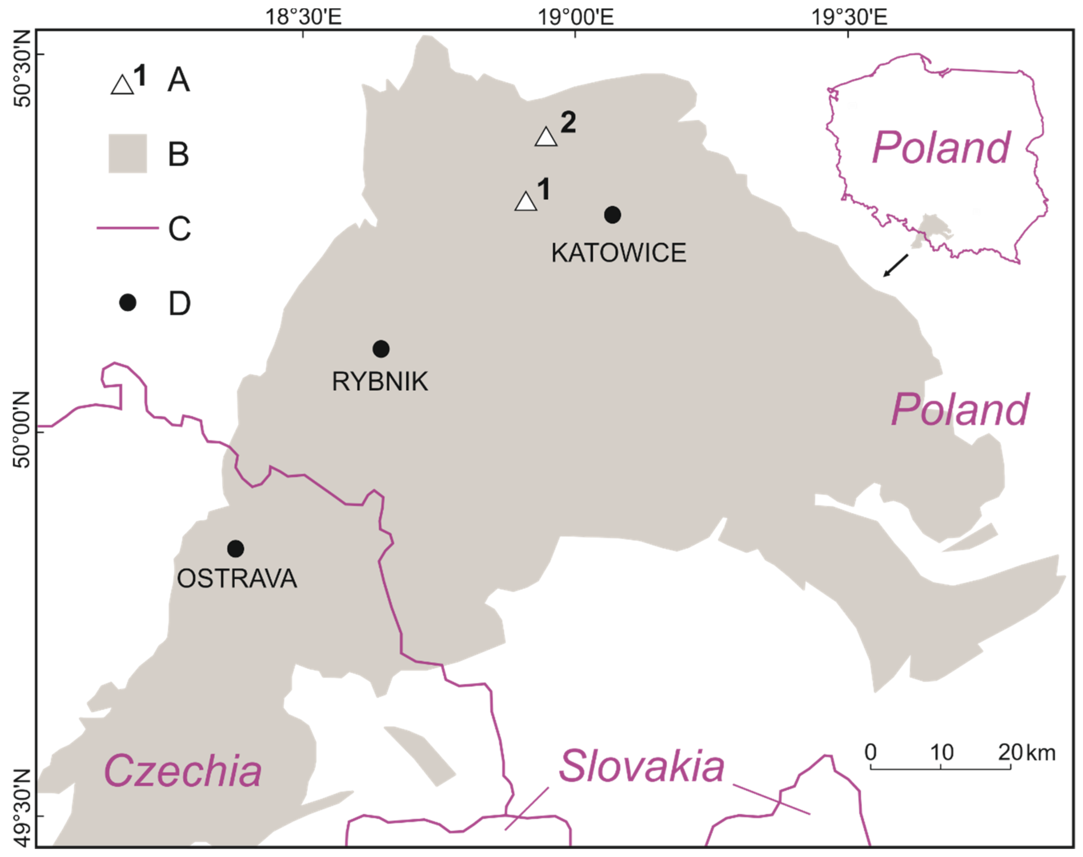
2.1. Study Area

The research covered two different objects from the Katowice Coal District in the Upper Silesian Coal Basin (later, USCB). The USCB is one of the largest coal basins located in Europe (Figure 1). It covers a total area of 7500 km2: 5600 km2 belongs to Poland (Silesian and Lesser Poland voivodships) and the rest to the Czech Republic (Moravian-Silesian region) [48,49]. Coal-waste dumps are a typical landscape feature in this area [25]. It is estimated that about 0.4–0.5 Mg of waste material is generated in the USCB per 1 Mg of produced coal [50,51], and the construction of one dump requires on average an area of 6 ha [52]. The dumps in the Polish part of USCB cover over 4000 ha of the entire area [51], which is 0.7% of the total area.
The first coal-waste dump (D-RS-1) is located in the city of Ruda Śląska, among residential buildings and a shopping mall. The dump was built in the 1990s to supplement the voids created by the Bielszowice brickyard [26,39]. Materials from the nearby Wawel mine were stored there and separated by insulation layers. After the end of storage, the area was secured with a soil layer, and vegetation was introduced. Unfortunately, the reclamation was unsuccessful, and most of the introduced plant are currently absent. The area covers over 9 ha and is relatively flat. This dump is currently managed by Spółka Restrukturyzacji Kopalń (mine restructuring company).
According to the division made in the framework of the European program Natura 2000, the investigated area belongs to the continental biogeographic region [53]. In terms of the Polish geobotanical region, the region belongs to the section of the South Polish Upland and the Upper Silesian geobotanical region. The share of biogeographic elements in the structure of potential natural vegetation of this land is represented by oceanic (12%), Central European (51%), continental (27%), boreal (1%), and mountain (9%) elements, and there are no Pontic and Mediterranean elements [54]. The main elements among plant associations are subcontinental oak-hornbeam forest (Carpinion betuli), as well as temperate continental pine forest and pine-oak forest (Dicrano-Pinion). Less contributions are a fir forest (Vaccinio-Piceion), light-oak forest (Quercetalia pubescentis), and submountain beech forest (Fagion). In turn, the potential vegetation of this area consists mainly of associations such as Tilio-Carpinetum, Calamagrostio-Quercetum, and Querco-Pinetum [55].
Ruda Śląska is situated at an altitude between 225 to 321 m above sea level, and Bytom is located between 249 to 346 m above sea level [56]. Both cities experience significant rainfall throughout the year, even in the driest months. Precipitation is lowest in February, with an average level of 32 mm [57]. The most rainfall occurs in July, with an average of 95 mm. The average annual rainfall is 686 mm. The average temperature is 8.6 °C. July is the warmest month of the year, while January has the lowest average temperature. The analyzed areas are located close to each other; hence, there are no slight differences between them. Both places are located in the zone of moderate, transition climates between maritime and continental zones.
The second coal-waste dump (D-B-2) is over 11 km away from the first one and is located on the outskirts of the city of Bytom, near the border with the city of Radzionków, among postindustrial facilities and the A1 highway. It is located in the northern part of the largest dump in Bytom [58]. This area was already used in the first half of the 20th century (the interwar period) to store waste from the Zn-Pb Nowy Dwór Mine (later the Ludwik Waryński Mining and Metallurgy Plant). In the 1950s and 1960s, there were large post-flotation settlers in the western part of the dump, and in the eastern part in the 1960s, exploitation of the old dumps was started, which was completed in 1976. In the 1980s and 1990s, the postmining waste from Radzionków Mine (from 1975, Powstańców Śląskich Mine) and slag from the liquidated dumps of the Łazarz zinc smelter (later, Radzionków) were stored in the eastern part of the dump. In the first decade of the 21st century, a highway was marked out through the post-flotation dump of the Nowy Dwór Mine; therefore, in 2011, the partial removal of the dump was started. However, the part investigated in this article is a relatively new formation, as it was built in this place within the last 10 years. Due to the type of stored materials, the dump can be divided into three parts. In the northern part, waste from the coal mine is stored. In the southern part, there is slag from the smelter. In the western part of the dump, municipal waste is illegally deposited. Currently, this area belongs mainly to the city of Bytom and partially to the city of Radzionków (northeastern part).

2.2. Cartographic Investigation

Spatial and temporal analyses of land relief and land cover in the area of the investigated coal-waste dumps were performed. For this purpose, publicly available historical cartographic materials were used, including orthophotomaps from the period of the 1930s–2017, located in open-access spatial databases (including Google Earth [59] and the Open-access Regional Spatial Information System—ORSIP [60]). To obtain current information on the surface of the investigated dumps, ground field observations were carried out and aerial photos taken, which allowed for the creation of a digital elevation model and an orthophotomap with a resolution of 3.5 cm. The obtained cartographic data was processed in the QGIS program, which allowed for an analysis of land cover and topography.

2.3. Thermal Investigation

From spring 2019 to summer 2020, field observations of the surface temperature of the stored material were carried out. Drone flights were carried out with the DJI S900 drone with a FLIR Vue Pro 336 infrared camera (spectral range: 7.5–13.5 μm), which later allowed a thermal map to be obtained for both coal-waste dumps.
Thermal measurements were also carried out with the use of a FLIR T640 hand-held thermal imaging camera (infrared resolution: 640 × 480, spectral range: 7.5–14 μm), which covered the self-heating zones of the investigated dumps. The exact time and date of the thermal infrared measurements were adapted to the weather conditions, which allowed us to avoid, among other things, the influence of sunlight and the effects of the cold sky [61,62]. The thermal photos were properly processed in FLIR Tools to make appropriate corrections [63].

2.4. Vegetation Investigation

The research on the transformation of the vegetation was carried out in two stages. The first period concerned the beginning of the growing season (April/May) and the second the full vegetation period (July/August). The scope of the research included floristic research, vegetation mapping, and phytosociological documentation.
The floristic investigation consisted of an inventory of plant species growing on dumps in both periods. The collected floristic material was characterized by determining its belonging to one of the socioecological groups according to Oberdorfer et al. [64] and its syntaxonomy (species characteristic for classes and orders) according to the study by Matuszkiewicz [65]. The type of Raunkiær lifeform [66] and its geographical and historical groups, such as apophytes and anthropophytes [67], were determined for each species. The systematic system of species was given according to Rutkowski [68]. The species names were adopted according to the study by Mirek et al. [67].

2.5. Vegetation Mapping

The first stage consisted of distinguishing patches of vegetation based on their color and the range of shrub-woody and herbaceous plants on a pattern from an open-access orthophotomap. In addition to this, field studies were conducted to verify the actual level of vegetation coverage. The distinguished plant communities were marked on the previously prepared pattern. To identify plant communities, phytosociological documentation was consulted on individually selected areas using the Braun-Blanquet method [69]. According to this method, to identify vegetation at the level of classes, orders, or associations, it is enough to identify the species characteristics that are distinctive for a given syntaxon.

3. Results

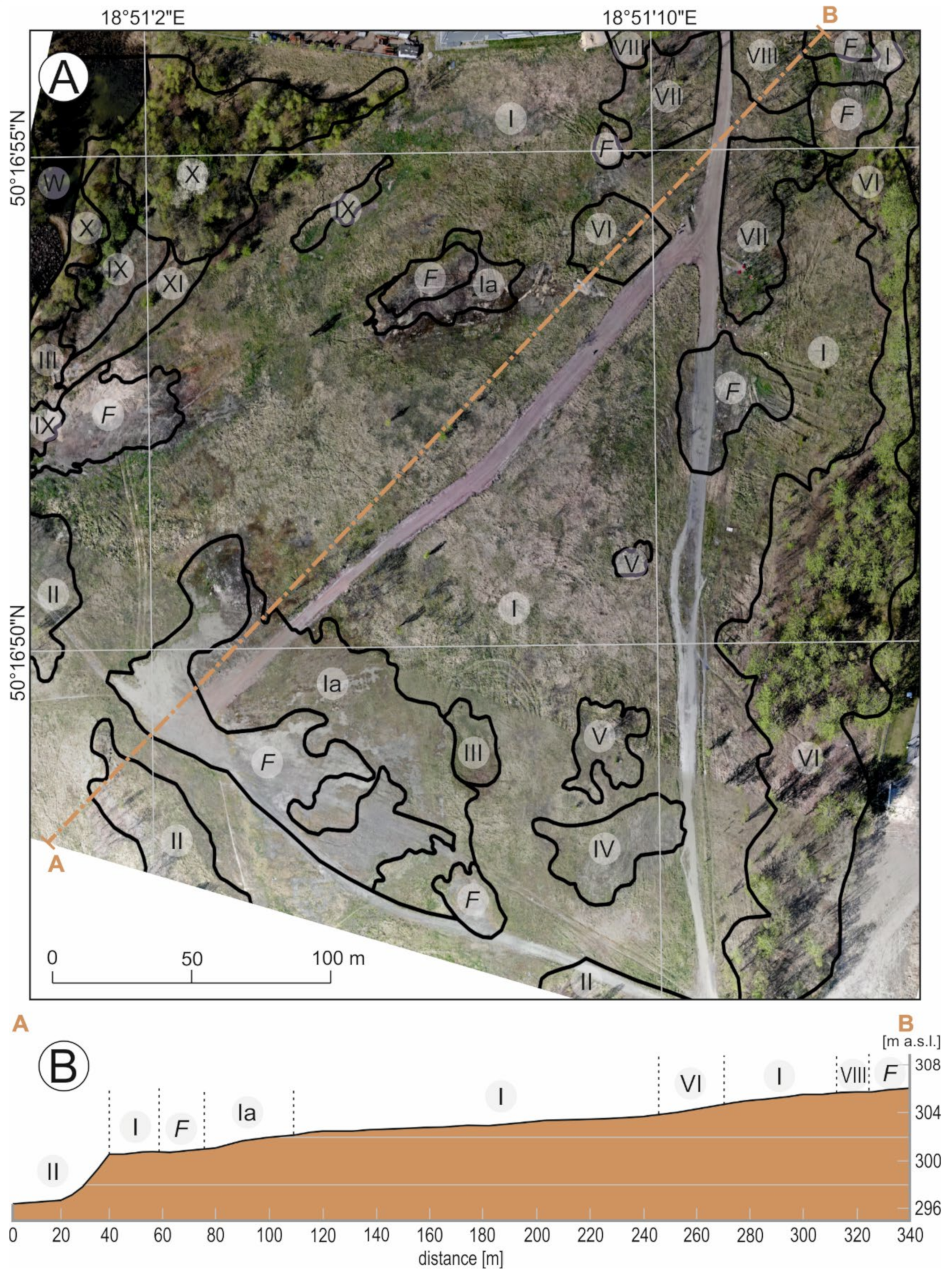
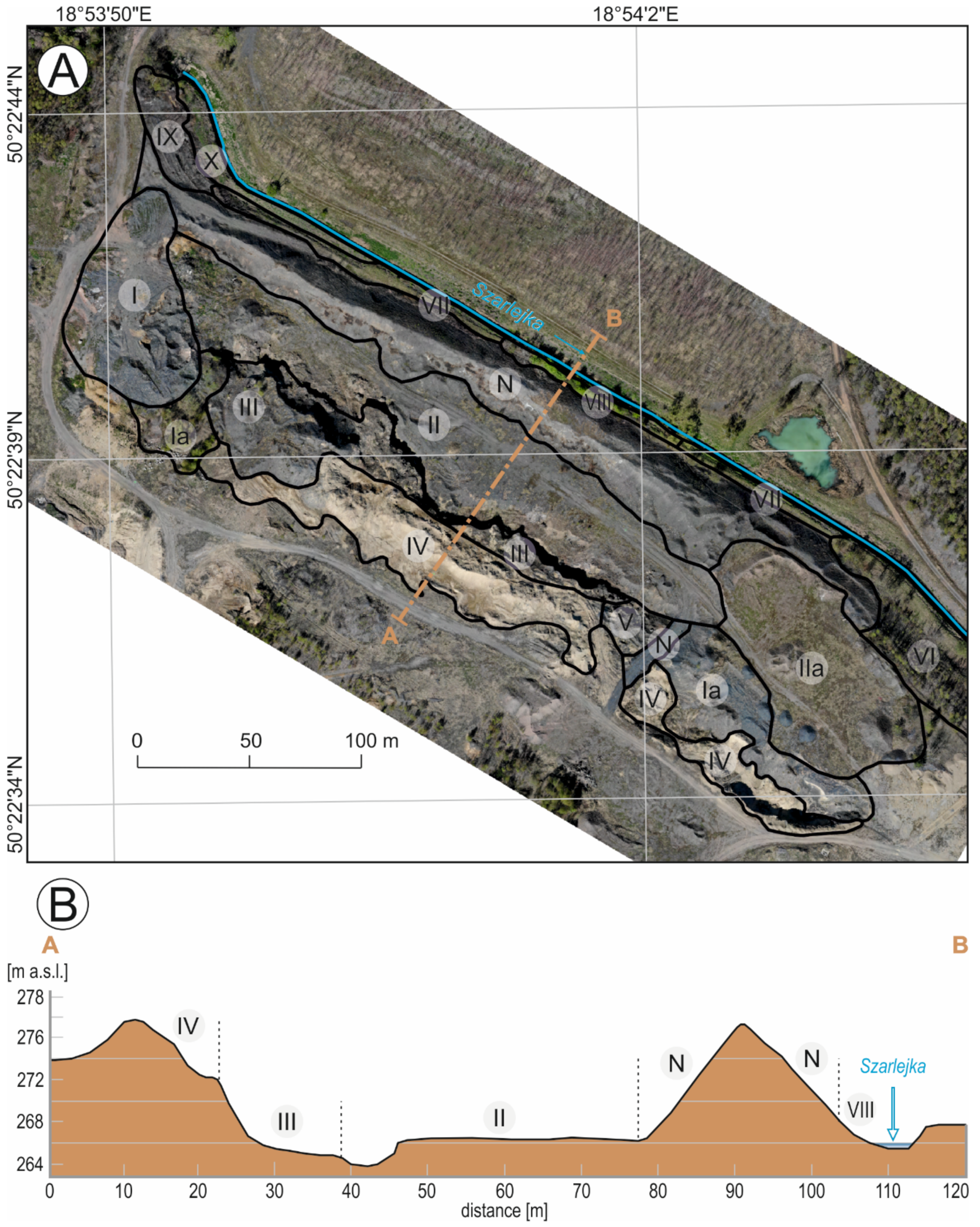
3.1. Topography and Structure

The coal-waste dump D-RS-1 currently covers an area of over 9 ha and shows a relatively flat topography in its northeastern and central parts. The area has a slope of 2° to the southwest. In the southwestern part, the slope of the land increases significantly, reaching 25°. The maximum height of the dump is 306 m above sea level, and the minimum height is 396 m above sea level (the height amplitude is, therefore, 10 m).
Until 1992, the analyzed area of D-RS-1 was an industrial area actively used by a brickyard, the voids of which are visible on historical maps (Figure 2). Changes in this area took place in 1992, when the voids were filled with coal material, and thus, a coal-waste dump was constructed. The dump D-RS-1 was initially located, when its construction began, in a poorly urbanized area but was well-connected with both residential estates (by road) and mining plants (by rail). Over the past 20 years, this area has changed. First, a supermarket with a shopping arcade was built on the plots adjacent to the northern part. Then, on the eastern side, buildings belonging to the district court were built. In recent years, plots to the west of the dump were developed in preparation for a road to be built there: the so-called route N-S. Ultimately, the landfill site is now located in urban areas, near residential buildings and road infrastructure.
The coal-waste dump D-B-2 is characterized by a more diversified topography (Figure 3). The dump covers an elongated area on the NW-SE line. Its NE border is Szarlejka River, which flows at the foot of an elongated embankment made of coal materials. The embankment is 300-m-long and 30-m-wide. Its slopes have NE and SW exposure and have an angle of 50°. On the SW side, the embankment borders a thirty-meter plane, which is horizontally arranged and also made of coal waste materials. On the other side of the above-mentioned plane, there is a 2-m-deep depression in the ground. This marks the border between the coal waste and post-smelting materials. Post-metallurgical waste also forms a positive (convex) form, but it is more irregular. From the NE side, its slope reaches a height of 278 m above sea level and collapses at an angle of 60°.
The D-B-2 dump is part of a larger postindustrial area that is far away from urban areas and was used as a store for waste material as early as the 19th century. Initially, this part was used to transport materials from the mine, which is indicated by the railway connections to this place visible on historical maps (including a topographic map at a scale of 1:10,000 in the 1965 system from 1973–1988). In 2012, the Bytom road junction on the A1 highway and a part of this highway were commissioned near this area (they are located 300 m south of the area where the investigated dump will later be built). Some of the waste materials that constitute the postmining areas around the current dump were used in the construction.
The features of both selected facilities are summarized in Table 1.

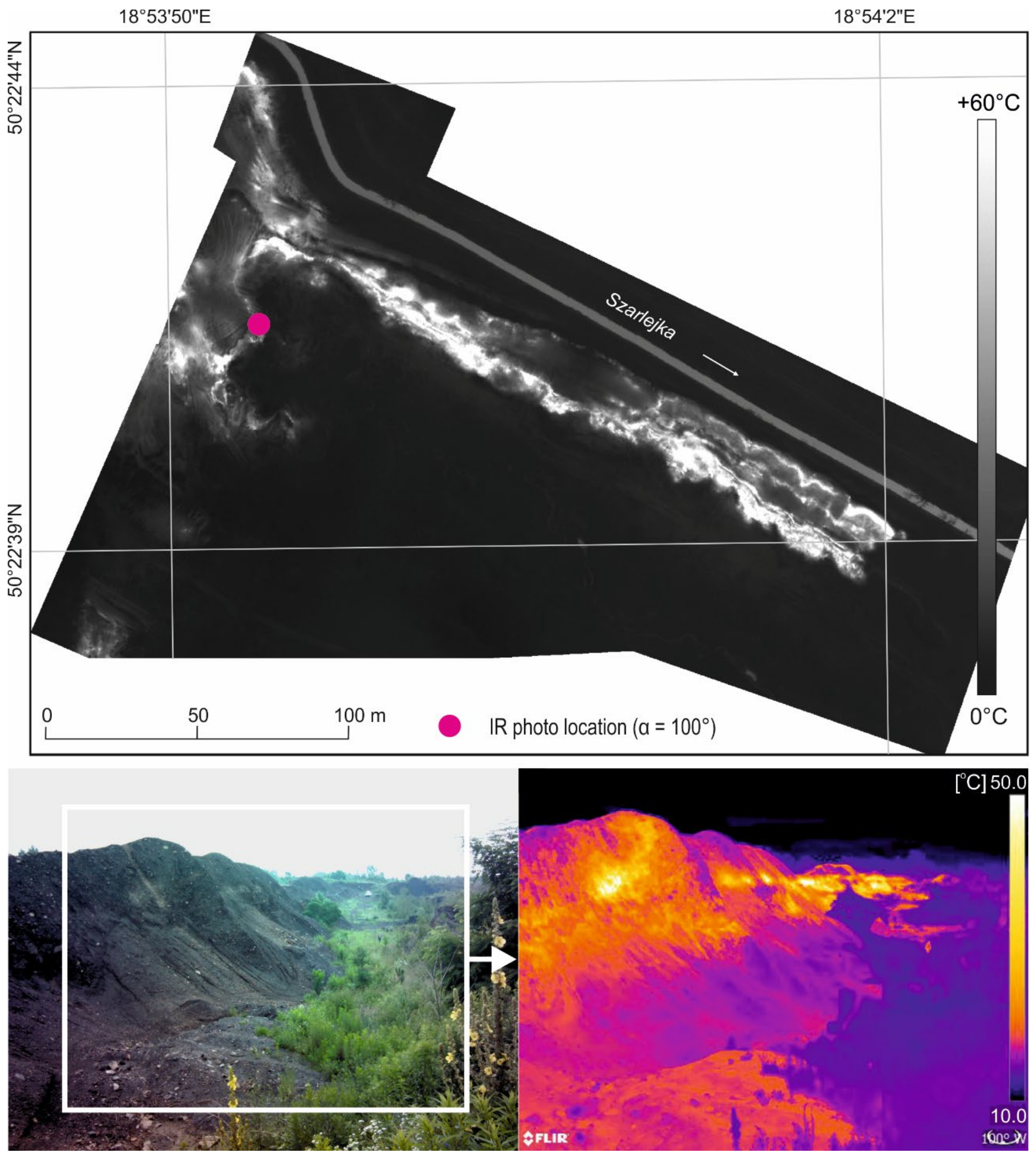
3.2. Thermal Conditions

The measurements carried out in the field identified thermally active zones in both dumps. In the D-RS-1 dump, they are spotty (Figure 4). Fires are irregularly distributed throughout the analyzed area and have different temperature ranges. The warmest identified zones are in the northwest and west of the dump. The surface temperatures measured there reach +60 °C, with an air temperature of −2 °C. In the northern and eastern parts, the thermally active zones reach temperatures of +20–25 °C.
The heating zones in the D-B-2 dump are linear at the height of about two-thirds of the slope of the coal embankment (Figure 5). The highest temperatures were recorded in the southeastern part of the dump, on its southwestern slope. They reach values exceeding +60 °C. The northeastern slope shows weaker thermal activity.

3.3. Flora Diversity

One-hundred and fifty species of vascular plants were found in the area of both coal-waste dumps. The flora of D-RS-1 was represented by 33 families, 99 genera, and 124 species, while 30 families, 62 genera, and 73 species of vascular plants were found on the D-B-2 dump (Figure 6).
The number of species varied within the investigated objects (Table 2). In the case of the Brassicaceae family, the number of species in both sites was almost similar, despite the different ages of the dumps. However, in the case of Poaceae, the number of species in D-RS-1 was four times greater than in D-B-2. Despite the different number of species within the families, Asteraceae and Brassicaceae dominated in each analyzed site, respectively.
In terms of the geographical and historical spectrum of their flora, both dumps are dominated by plants derived from native natural habitats—apophytes occurring in anthropogenic habitats. In D-RS-1, they number 90 (i.e., over 72% of the entire flora), while in D-B-2, there are 57 species (78% of the entire flora). In turn, in both dumps, there is a much lower share of anthropophytes (archaeophytes, epherophytes, and kenophytes), which account for 22% of the flora (16 species) of the D-B-2 dump and almost 28% of the flora (34 species) of D-RS-1. In the area of the D-RS-1, reclamation took place, and then selected plant species were introduced there, including Populus alba, Robinia pseudoacacia, Cornus alba, and Sambucus nigra [70], which had an impact on the species richness in this area. Unfortunately, most of the specimens did not adopt the harsh conditions and were destroyed by thermal processes.

3.4. Vegetation Community in D-RS-1

From the vegetation mapping, 11 vegetation patches were distinguished, representing both forest-scrub and nonforest communities with different areas and degrees of density (Figure 7 and Figure 8). In the area where self-heating does not occur or has burned out, relatively compact communities are formed, often with the domination of one species. Nonforest communities with the occurrence and dominance of Erigeron annuus, Calamagrostis epigejos, and Solidago canadensis can be mentioned here. These are pioneering species in the initiation of spontaneous succession in postmining waste landfill sites, thanks to their morphological adaptations and wide ecological tolerance to the conditions in such a habitat. These communities are accompanied by species representing various socioecological groups, such as Artemisia vulgaris, Amaranthus retroflexus, Cerastium semidecandrum, Descurainia sophia, Echium vulgare, Erigeron acris, Erigeron canadensis, Jasione montana, Eragrostis minor, Poa annua, and others (Table S1).
Forest-scrub communities were distinguished, mainly patches of Populus-Salix (community XII), Robinia pseudoacacia (II), a tree stand of Betula pendula-Tilia cordata, and an artificial stand of Populus × canadensis (VI). An artificial hybrid poplar plantation was established during the reclamation of the dump and is of both landscape and ecological importance. The following species entered its periphery: Populus tremula, Tilia platyphyllos, T. cordata, Acer platanoides, A. pseudoplatanus, Quercus robur, Betula pendula, Salix fragilis, Sorbus aucuparia, Corylus avellana, and Padus serotina, pointing to the direction of succession being towards the forest.
Shrubs of Robinia pseudoacacia (VII and V) occupy a small surface area and are loose in structure, and therefore, their undergrowth is overgrown by Calamagrostis epigejos, Solidago canadensis, and Arctium lappa. They are nitrophilous species, forming communities on organic waste of ex-situ origin. Thickets of R. pseudoacacia are accompanied by clumps of Populus tremula, Salix caprea, Acer pseudoplatanus, Sambucus nigra, Pyrus communis, Crataegus monogyna, and Philadelphus coronarius. The origin of fruiting (Cerasus vulgaris, Padus serotina, Pyrus communis, and Prunus spinosa) and decorative species (Philadelphus coronarius, Deutzia scabra, and Rudbeckia laciniata) may be related to the allotment gardens adjacent to the dump on the east side of the site.
The largest part of the area is covered with by grass, forming meadows and covering over 75% of the entire dump (Table 3). A significant part is also covered by tree stands, i.e., over 12% of the area. The diversity of plant communities in this area is determined by the rate and frequency of fires, not only the morphology of the area. Since 2002, the plant cover on the dump has been subject to local damage, which is visible, among other places, in orthophotomaps from this year. The first visible zones without vegetation appear in the northern part of the dump and, then, in the following years spread to cover its other parts. These zones are distributed irregularly on the surface of the dump and differ in sizes. The investigated surface is relatively flat, and the presence of depressions here and there is associated with technical works aimed at preventing fires by applying a protective layer. A lot of water is collected in these depressions, and this is of significant (although local) importance in terms of the water conditions and in maintaining moisture in the substrate in such an extreme habitat for the development of photosynthetic organisms. It should be emphasized that, on the south side of the studied site, the studied area is surrounded by deciduous forest with a large share of clones, which is the genetic basis for succession on the dump.

3.5. Vegetation Community in D-B-2

The area of the investigated dump does not appear in the cartographic materials until 2011. It took its current form a year later. Over the following years, you can see the slow encroachment of vegetation into this area, but it is mainly concentrated in the southwestern part and at the foot of the northwestern slope of the coal embankment (on the Szarlejka River). Most of the dump is currently covered with low vegetation, 65.49% (Table 3). However, a large area of more than 19% remains without cover.
On D-B-2, communities with a dominance of Erigeron canadensis, Eupatorium cannabinum, Solidago virgaurea, and Calamagrostis epigejos were distinguished (Figure 9). The species composition of the communities is similar to those in D-RS-1. The communities of E. cannabinum and S. virgaurea deserve special attention, as they have colonized the recessed parts of the land on loose and fine-grained substrate. The height of the specimens reaches 170 cm; they grow in the form of tufts and show exceptional vitality, resulting from their development on a fine-grained fraction and with water flowing from the adjacent slopes. The substrate is additionally enriched by discarded organic waste. In the area of the dump, there are shrubs, both single and mixed, with the occurrence of pioneering tree and shrub species. The main scrubs to be mentioned are Populus × canadensis, Acer negundo, Populus tremula-Betula pendula, Populus tremula-Betula pendula-Salix caprea, Pinus sylvestris-Betula pendula, and Salix caprea. Some of the birch and willow thickets have been burnt or died off due to an active fire. In each of the investigated dumps, the ecological processes are similar but with a different intensity.
The D-B-2 dump differs from D-RS-1 in terms of age, fire rate, and relief, which has a significant impact on the rate and development of vegetation. Steep slopes (up to approx. 10 m in height), which are frequently eroded, do not favor the colonization process and are often completely devoid of vegetation cover (Figure 10). A similar situation is observed in depressions where there is no solar radiation. The bottom of the dump is highly composted; the overgrowing vegetation is low and does not form a compact turf when compared to the western part. In the area of this dump, communities are characterized by a loose structure and appear in the form of a mosaic. From the vegetation mapping, 10 patches of vegetation representing shrub and nonforest communities are distinguished (Figure 9).

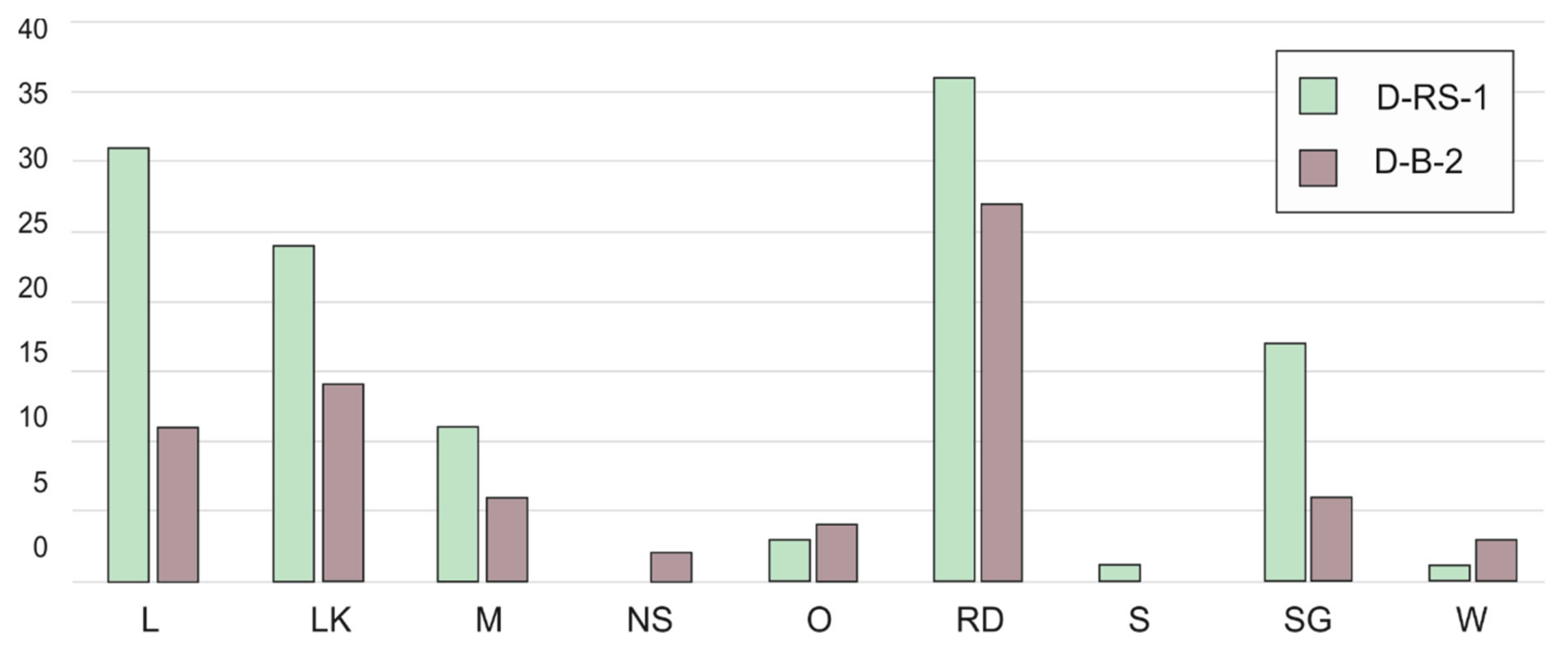
3.6. Socioecological Diversity of Flora

Within the distinguished socioecological groups of the studied flora [64,65], a relatively high share of 36.9% (i.e., 27 species) in D-B-2 and 29.03% (i.e., 36 species) in D-RS-1 show a group of species from anthropogenic ruderal and segetal habitats (from classes Artemisietea, Stellarietea mediae, and Polygono-Chenopodietalia; Table 4). Groups of meadow species (class Molinio-Arrhentheretea) and grassland species (classes: Festuco-Brometea and Sedo-Scleranthetea) are clearly visible, especially in the D-RS-1 dump (Figure 11). The shares of deciduous forest species (classes: Querco-Fagetea, Alneta glutinosae) and coniferous habitats (Vaccino-Piceetea) are relatively low, accounting for a total of 15% in the D-B-2 dump and about 25% for D-RS-1. The syntaxonomic associations of the studied flora were defined at the level of 16 classes (the highest rank in the syntaxonomic taxonomy in phytosociology) and 18 orders (Table 4). These groups define species that grow together in natural and semi-natural conditions (except for anthropogenic habitats) due to common habitat requirements. In such an approach, the presence of species (especially the dominant species) representing particular groups on dumps indicates the presence of a diversity of habitats in the dumps that they colonize.
A clear difference can be observed in both dumps of different ages; this is indicated both by the difference (although slight) in the number of socioecological groups and the difference in the number of dominant species representing the distinguished groups (Figure 11).

3.7. The Raunkiær Plant Life-Forms

The analysis of the spectrum of lifeforms shows a clear dominance of perennial plants (Figure 12) in both sites: 46.7% (i.e., 58 species) in D-RS-1 and 67% in D-B-2 (49 species). The share of megaphanerophytes (14%, i.e., 18 species), nanophanerophytes (11.2%, 14 species), and therophytes (17.7%, i.e., 22 species) in the flora of D-RS-1 is greater than in the younger D-B-2 dump. In both dumps, as a result of self-heating (Figure 4 and Figure 5), habitats are often completely destroyed, which also affects the distribution of lifeforms.

4. Discussion

Mining leads to high urbanization in a very short time, attracting a large number of jobseekers. The scale of this migration leads to important environmental changes [9], which is also visible in the USCB, which is one of the most densely populated areas not only in Poland [71] but, also, in Europe. This requires the appropriate design and adaptation of the postmining landscape following the best technological practice and land development standards [72]. Implementing strict environmental protection measures helps to reduce ecological damage during coal mining and reverse so-called environmental injustice [2,9]. The changes that take place in postmining areas, including coal-waste dumps, prove that natural succession spontaneously recovers areas lost to industry. Even areas not subjected to planned reclamation, under favorable conditions, regain or assume their natural functions and environmental stability over time [73,74].
The effects of mining anthropo-pressure on the relief in the Upper Silesian Coal Basin are among the most serious in the world [48] and require appropriate management. In the case of coal-waste dumps, the negative effects mainly include problems with the stability of slopes, erosion, ground, and landscape disturbances, which may lead to changes in ecosystems and limit the possibilities of using these areas for economic purposes [23]. It is much more difficult to reduce these effects in the case of convex (positive) forms, such as dump D-B-2. This is due to the fact that conical and shaft forms are less stable than flat forms and are more susceptible to external factors and, thus, make the processes of the formation of ecological systems difficult (Figure 10). However, the difficulties resulting from the morphology of the site should not discourage people from taking action; land recovery and reclamation and the ecological restoration of dumps should be promoted, as should that of subsidence areas or areas of planned mines, all the more so as the ecological potential of the landscapes recreated later has proven [2,75]. Regardless of the original shape of the dump, nature, due to its properties, may, in time, integrate the reclaimed structure into the surrounding, undisturbed landscape [72].
Coal mining also changes the physical landscape of the coal basin [9]. The postmining landscape of the dumps can be left without management (e.g., D-B-2) or changed towards reclamation (e.g., D-RS-1). The types of reclamation are closely related to spatial planning, and the degree of interference depends on local needs [76]. The most important issue to consider when planning a reclamation is the type of development of the postmining site, since the costs of rehabilitation depend on the type of proposed development of the postmining site. The most common uses of postmining land currently include agriculture (grazing and crops), forestry, lakes (for various purposes), recreational areas, habitat protection areas, areas for industrial or construction activities, and areas for backfilling with other waste [23,77]. As reclamation progresses, landscape diversity and ecological stability increase [15]. Both investigated dumps fit perfectly into these trends: as an area surrounded by residential and service buildings, D-RS-1 complements this with recreational functions. On the other hand, D-B-2, as an integral part of a larger postindustrial area, is somewhat synchronized with the surrounding areas.
The self-heating phenomena that occur in dumps are undoubtedly a threat to the environment, society, and infrastructure. Contrary to appearances, however, they do not paralyze natural processes but only change their direction. Subsurface fires primarily lead to changes in the substrate, which, after the cessation of high temperatures, is quickly colonized by vegetation. The elevated temperatures also create completely different habitat conditions, attracting new species (thermophilic and xerophytic plants) and, thus, increasing biodiversity. Fires, despite their negative sides, can also be an impulse for completely different use of coal dumps. With appropriate protection, these objects can be an educational area or a geo-tourist attraction, such as the burning Emma dump in the Czech Republic [78]. This opens up new opportunities and a completely different view of the underestimated postmining heritage [79,80].
Spontaneous ecological succession can be considered a natural and optimal way of managing postmining dumps, and their process and direction depend primarily on the type of bedrock material (waste) and its properties [41,81,82,83]. Waste materials with a high content of organic matter and a small or medium fraction favor the colonization of vegetation [84,85]. This is due to high water capacity and soil aeration. In the area of the studied dumps, the stored material has a heterogeneous nature and is characterized by a significant amount of clay fraction, which does not favor the rapid formation of plant communities compared to wastelands with a fine-grained fraction [40].
In most territories of the investigated dumps, the process of overgrowing is spontaneously initiated by herbaceous plants of the Solidago canadensis and Calamagrostis epigejos species, often creating compact communities (D-RS-1). Apart from the aforementioned taxa, in the studied areas, during spontaneous succession, groups of species with anemochoric and anemogamous types of development, including those from the Asteraceae family, have a significant share. As in other postmining landscapes, in nonreclaimed areas, vegetation succession is mainly initiated by C. epigejos [47,86]. This is due to the production of a large amount of light and volatile seeds that facilitate their spread. In this way, they can be the first to colonize areas devoid of natural soil cover.
Ecological systems naturally encroaching or introduced into the landscape by a human slowly undergo spontaneous transformation due to natural succession and environmental disturbances [15]. The process of phytocoenosis formation in this area is closely related to the dynamics and frequency of fires. As a result, the formed communities are completely destroyed, and slow-progressing fires cause the vegetation to dry up. In the zone where fires have subsided, the substrate is characterized by good water–air conditions resulting from the dominance of the fine-grained fraction with a relatively loose structure of the substrate, in contrast to the areas with a larger fraction; hence, the species growing here (Lepidium ruderale and Reseda lutea) show a high viability in their morphology (branchy clumps). A similar situation is observed on anthropogenically loosened surfaces covered with organic waste, where the fertility and water–air conditions in the soil improve, which, in turn, contributes to quick settlement. For this reason, the species (Chenopodium album, Amaranthus retroflexus, and Verbascum thapsus) that develop here, similarly to the postfire zone, have extensive clumps and show high vitality. In most cases, herbaceous species differ morphologically (e.g., in growth and branching) from those growing in natural conditions. On exposed and sunlit clay surfaces in columnar forms (protected against erosion), some species (Hypericum perforatum and H. maculatum) take a branched form and reproduce in a vegetative manner, forming small rows due to the lack of available water, and here, they often die. In the initial stages of succession in fire and postfire zones, thread algae and bryophytes—mainly, Tortula ruralis—enter and consolidate the substrate, increasing its retention. The algae–moss crust is a potential substrate for new recruits on this surface.
The variety and species richness of the investigated coal-waste dumps correspond to other postindustrial areas in Poland and Europe, even though two relatively young, small-area dumps were taken into account. Research conducted by other authors confirmed the irregularity of plant communities, disturbed vegetation cycle, and problems with the absorption of introduced vegetation on burning coal-waste dumps. The spontaneous spread of species on a burning conical dump in Poland (the town of Czerwionka-Leszczyny) was also noticed by Zając and Zarzycki [87]. Their results confirmed changes in the vegetation in the vertical profile of the investigated object, including the complete absence of vegetation in the top part, which was also observed on D-B-2. Ciesielczuk et al. [34], while studying the burning dump in Katowice, observed mosaic-like plant communities similar to D-RS-1. Although the dump had a different shape (an asymmetric coal-pile), it was created at a similar time (1991–1996) and was subject to similar protection and reclamation processes (they were also unsuccessful). The reclamation of similar objects in Europe was more widely dealt with by Šebelíková et al. [88], who compared different methods of revegetation at several sites in Germany, the Czech Republic, and Hungary. Their analyses showed that spontaneous revegetation is as effective as forestry reclamation, differing only in the species richness of plants. A large number of vascular plant species have been found in the Czech Republic [89] and in the area of postmining dumps of Donbas; as a result of spontaneous succession, 260 species of vascular plants have been found there [90]. In Western Ukraine (Lviv-Volyn Basin), attention was paid to the problem of the plant reclamation of dumps, where, due to fire, the introduced species are not accepted (fire destroys the root system) [91]. On the coal-waste dumps of Upper Silesia, Rostański [41] lists 580 plant species, which is about one-fifth of the Polish flora species. Many studies presented the causes of diversity; the richness of species in the dumps surrounded by the city; and the agricultural, industrial, and forest areas. It was found that dumps in cities are richer in species, which is due to the considerable richness of the urban flora [42,92,93,94,95].

5. Conclusions

Coal-waste dumps, despite their thermal activity, are willingly and spontaneously inhabited by vegetation, but the way it enters and the way it covers the dump depends, on a large extent, on the shape of the dump, the way it is built, its exposure, and the development of the surrounding areas, as well as the course of thermal processes. Vegetation transformation in anthropogenic habitats is, to some extent, similar to natural and semi-natural habitats, but many aspects of vegetation development are specific only to anthropogenic habitats. Both of the analyzed sites were dominated by ruderal and meadow species belonging to the Artemisietea and Molinio-Arrhenatheretea classes related to the transformed habitats. The vegetation communities and flora diversity were conditioned not only by changes over time but, mainly, by the varieties of ecological niches of mosaic and micro-mosaic characteristics and the delivery of propagules from neighboring areas. In the coal-waste dumps, there are accumulations of mosaics of extreme habitats, which generate a different course of succession, and it is not easy to determine the final stages of vegetation development in these areas. Carrying out a comprehensive reclamation in this kind of area is very problematic due to dynamic thermal processes. Research has shown that, in the case of burning coal-waste dumps, the introduction of vegetation has no effect if the object is not adequately protected against fire development. In such a case, spontaneous succession is the only solution, which was also confirmed by the results of other authors.
Despite being an inseparable element of the landscape of coal basins, dumps have a huge impact on changes in the local landscape. They are very dynamic objects that, if properly managed, can enrich the landscape and make it more attractive and, at the same time, have a positive impact on the biodiversity.

Supplementary Materials

The following are available online at https://www.mdpi.com/2073-445X/10/1/23/s1: Table S1: Plant list.

Author Contributions

Conceptualization, A.A. and O.R.; methodology, A.A. and O.R.; validation, A.A. and O.R.; formal analysis, A.A.; investigation, A.A., O.R., and R.C.; resources, A.A. and R.C.; data curation, A.A.; writing—original draft preparation, A.A. and O.R.; writing—review and editing, A.A. and R.C.; and visualization, A.A. and R.C. All authors have read and agreed to the published version of the manuscript.

Funding

This research received no external funding.

Institutional Review Board Statement

Not applicable.

Informed Consent Statement

Not applicable.

Data Availability Statement

Not applicable.

Conflicts of Interest

The authors declare no conflict of interest.

References

  1. Hilson, G. Pollution prevention and cleaner production in the mining industry: An analysis of current issues. J. Clean. Prod. 2000, 8, 119–126. [Google Scholar] [CrossRef]
  2. Xu, J.; Zhao, H.; Yin, P.; Wu, L.; Li, G. Landscape ecological quality assessment and its dynamic change in coal mining area: A case study of Peixian. Environ. Earth Sci. 2019, 78, 708. [Google Scholar] [CrossRef]
  3. Dulias, R. Landscape planning in areas of sand extraction in the Silesian Upland, Poland. Landsc. Urban Plan. 2010, 95, 91–104. [Google Scholar] [CrossRef]
  4. Gorova, A.; Pavlychenko, A.; Kulyna, S. Ecological Problem of post-mining areas. In Geomechanical Processes During Underground Mining; Pivnyak, G., Bondarenko, V., Kovalevs’ka, I., Illiashov, M., Eds.; CRC Press: Boca Raton, FL, USA, 2012; ISBN 978-0-415-66174-4. [Google Scholar]
  5. Lei, K.; Pan, H.; Lin, C. A landscape approach towards ecological restoration and sustainable development of mining areas. Ecol. Eng. 2016, 90, 320–325. [Google Scholar] [CrossRef]
  6. Mi, J.; Yang, Y.; Zhang, S.; An, S.; Hou, H.; Hua, Y.; Chen, F. Tracking the Land Use/Land Cover Change in an Area with Underground Mining and Reforestation via Continuous Landsat Classification. Remote Sens. 2019, 11, 1719. [Google Scholar] [CrossRef] [Green Version]
  7. Banks, G. Mining and the environment in Melanesia: Contemporary debates reviewed. Contemp. Pac. 2002, 14, 39–67. [Google Scholar] [CrossRef] [Green Version]
  8. Mensah, S.O.; Okyere, S.A. Mining, Environment and Community Conflicts: A Study of Company-Community Conflicts over Gold Mining in the Obuasi Municipality of Ghana. J. Sustain. Dev. Stud. 2014, 5, 64–99. [Google Scholar]
  9. Milbourne, P.; Mason, K. Environmental injustice and post-colonial environmentalism: Opencast coal mining, landscape and place. Environ. Plan. A Econ. Space 2016, 49, 29–46. [Google Scholar] [CrossRef]
  10. Si, H.; Bi, H.; Li, X.; Yang, C. Environmental evaluation for sustainable development of coal mining in Qijiang, Western China. Int. J. Coal Geol. 2010, 81, 163–168. [Google Scholar] [CrossRef]
  11. Demirel, N.; Düzgün, Ş.; Emil, M.K. Landuse change detection in a surface coal mine area using multi-temporal high-resolution satellite images. Int. J. Min. Reclam. Environ. 2011, 25, 342–349. [Google Scholar] [CrossRef]
  12. Laurence, D. Establishing a sustainable mining operation: An overview. J. Clean. Prod. 2010, 19, 278–284. [Google Scholar] [CrossRef]
  13. Hendrychová, M. Reclamation success in post-mining landscapes in the Czech Republic: A review of pedological and biological studies. J. Landsc. Stud. 2008, 1, 63–78. [Google Scholar]
  14. Hu, Z.Q.; Xiao, W.; Wang, P.J.; Zhao, Y.L. Concurrent mining and reclamation for underground coal mining. J. China Coal Soc. 2013, 38, 301–307. [Google Scholar]
  15. Hendrychová, M.; Kabrna, M. An analysis of 200-year-long changes in a landscape affected by large-scale surface coal mining: History, present and future. Appl. Geogr. 2016, 74, 151–159. [Google Scholar] [CrossRef]
  16. Huang, Y.; Zhang, J.; Zhang, Q.; Nie, S. Backfilling technology of substituting waste and fly ash for coal underground in China coal mining area. Environ. Eng. Manag. J. 2011, 10, 769–775. [Google Scholar] [CrossRef]
  17. Pactwa, K.; Woźniak, J.; Dudek, M. Coal mining waste in Poland in reference to circular economy principles. Fuel 2020, 270. [Google Scholar] [CrossRef]
  18. Sokół, W.; Tabor, A. Problemy zagospodarowania odpadów powęglowych z górnictwa węgla kamiennego w Polsce. Przegląd Geologiczny 1996, 44, 710–715. [Google Scholar]
  19. National Research Council; Division on Earth and Life Studies; Board on Earth Sciences and Resources; Committee on Earth Resources; Committee on Coal Waste Impoundments. Coal Waste Impoundments: Risks, Responses, and Alternatives; National Academies Press: Washington, DC, USA, 2002; ISBN 030908251X. [Google Scholar]
  20. Borowski, G.; Hycnar, J.J. Utilization of Fine Coal Waste as a Fuel Briquettes. Int. J. Coal Prep. Util. 2013, 33, 194–204. [Google Scholar] [CrossRef]
  21. Wójcik, J. Zróżnicowanie kształtu i cech morfometrycznych zwałów jako podstawa do oceny przeobrażenia rzeźby terenu przez górnictwo węglowe. Badania Fizjograficzne 2006, 57, 149–159. [Google Scholar]
  22. Zástěrová, P.; Marschalko, M.; Niemiec, D.; Durďák, J.; Bulko, R.; Vlček, J. Analysis of Possibilities of Reclamation Waste Dumps after Coal Mining. Procedia Earth Planet. Sci. 2015, 15, 656–662. [Google Scholar] [CrossRef] [Green Version]
  23. Adibee, N.; Osanloo, M.; Rahmanpour, M. Adverse effects of coal mine waste dumps on the environment and their management. Environ. Earth Sci. 2013, 70, 1581–1592. [Google Scholar] [CrossRef]
  24. Prakash, A.; Fielding, E.J.; Gens, R.; Van Genderen, J.L.; Evans, D.L. Data fusion for investigating land subsidence and coal fire hazards in a coal mining area. Int. J. Remote Sens. 2001, 22, 921–932. [Google Scholar] [CrossRef]
  25. Jelínek, P.; Marschalko, M.; Lamich, D.; Yilmaz, I.; Zastěrová, P.; Bednárik, M.; Heviánková, S.; Kyncl, M.; Drusa, M.; Růčková, H. Monitoring and analysis of burning in coal tailing dumps: A case study from the Czech Republic. Environ. Earth Sci. 2015, 73, 6601–6612. [Google Scholar] [CrossRef]
  26. Nádudvari, Á.; Abramowicz, A.; Fabiańska, M.J.; Misz-Kennan, M.; Ciesielczuk, J. Classification of fires in coal waste dumps based on Landsat, Aster thermal bands and thermal camera in Polish and Ukrainian mining regions. Int. J. Coal Sci. Technol. 2020. [Google Scholar] [CrossRef]
  27. Civeira, M.S.; Pinheiro, R.N.; Gredilla, A.; de Vallejuelo, S.F.O.; Oliveira, M.L.S.; Ramos, C.G.; Traffarel, S.R.; Kautzmann, R.M.; Madariaga, J.M.; Silva, L.F.O. The properties of the nano-minerals and hazardous elements: Potential environmental impacts of Brazilian coal waste fire. Sci. Total Environ. 2016, 544, 892–900. [Google Scholar] [CrossRef] [PubMed]
  28. Ribeiro, J.; Flores, D.; Ward, C.R.; Silva, L.F.O. Identification of nanominerals and nanoparticles in burning coal waste piles from Portugal. Sci. Total Environ. 2010, 408, 6032–6041. [Google Scholar] [CrossRef]
  29. Ribeiro, J.; Suárez-Ruiz, I.; Ward, C.R.; Flores, D. Petrography and mineralogy of self-burning coal wastes from anthracite mining in the El Bierzo Coalfield (NW Spain). Int. J. Coal Geol. 2016, 154–155, 92–106. [Google Scholar] [CrossRef]
  30. O’Keefe, J.M.K.; Henke, K.R.; Hower, J.C.; Engle, M.A.; Stracher, G.B.; Stucker, J.D.; Drew, J.W.; Staggs, W.D.; Murray, T.M.; Hammond, M.L., III; et al. CO2, CO, and Hg emissions from the Truman Shepherd and Ruth Mullins coal fires, eastern Kentucky, USA. Sci. Total Environ. 2010, 408, 1628–1633. [Google Scholar]
  31. Kuenzer, C.; Zhang, J.; Tetzlaff, A.; van Dijk, P.; Voigt, S.; Mehl, H.; Wagner, W. Uncontrolled coal fires and their environmental impacts: Investigating two arid mining regions in north-central China. Appl. Geogr. 2007, 27, 42–62. [Google Scholar] [CrossRef]
  32. Ciesielczuk, J.; Misz-Kennan, M.; Hower, J.C.; Fabiańska, M.J. Mineralogy and geochemistry of coal wastes from the Starzykowiec coal-waste dump (Upper Silesia, Poland). Int. J. Coal Geol. 2014, 127, 42–55. [Google Scholar] [CrossRef]
  33. Tobin-Janzen, T.; Shade, A.; Marshall, L.; Torres, K.; Beblo, C.; Janzen, C.; Lenig, J.; Martinez, A.; Ressler, D. Nitrogen changes and domain bacteria ribotype diversity in soils overlying the Centralia, Pennsylvania underground coal mine fire. Soil Sci. 2005, 170, 191–201. [Google Scholar] [CrossRef]
  34. Ciesielczuk, J.; Czylok, A.; Fabiańska, M.J.; Misz-Kennan, M. Plant occurrence on burning coal waste–a case study from the Katowice-Wełnowiec dump, Poland. Environ. Soc. Econ. Stud. 2015, 3, 1–10. [Google Scholar] [CrossRef] [Green Version]
  35. Pertile, E.; Fečko, P.; Nezvalová, L.; Guziurek, M.; Wolfová, R.; Tora, M. Reclamation using waste rock impact on water quality in the Karvina region in Czech Republic. Inżynieria Mineralna 2010, 11, 33–39. [Google Scholar]
  36. Pertile, E.; Surovka, D.; Sarčáková, E.; Božoň, A. Monitoring of Pollutants in an Active Mining Dump Ema, Czech Republic. Inżynieria Mineralna 2017, 18, 45–50. [Google Scholar]
  37. Tichanek, F.; Tichanek, R. Contribution to the solution of thermally active reclamation of coal waste heaps. In Proceedings of the International Multidisciplinary Scientific GeoConference: SGEM, Albena, Bulgaria, 17–26 June 2014; pp. 777–791. [Google Scholar]
  38. Marcisz, M.; Probiesz, K.; Gawor, Ł. Possibilities of reclamation and using of large-surface coal mining dumping grounds in Poland. Gospod. Surowcami Miner. Miner. Resour. Manag. 2020, 36, 105–122. [Google Scholar]
  39. Łączny, J.M.; Baran, J.; Ryszko, A. Opracowanie i Wdrażanie Innowacyjnych Technologii Środowiskowych Stosowanych na Zwałowiskach Odpadów Powęglowych; Wydawnictwo Naukowe Instytutu Technologii Eksploatacji–PIB: Radom, Poland, 2012; p. 300. [Google Scholar]
  40. Rahmonov, O.; Krzysztofik, R.; Środek, D.; Smolarek-Lach, J. Vegetation- and Environmental Changes on Non-Reclaimed Spoil Heaps in Southern Poland. Biology 2020, 9, 164. [Google Scholar] [CrossRef]
  41. Rostański, A. Spontaneous Plant Cover on Colliery Spoil Heaps in Upper Silesia (Southern Poland); University of Silesia Publisher: Katowice, Poland, 2006; p. 230. [Google Scholar]
  42. Woźniak, G. Diversity of Vegetation on Coal-Mine Heaps of the Upper Silesia (Poland); W. Szafer Institute of Botany-Polish Academy of Sciences: Cracow, Poland, 2010. [Google Scholar]
  43. Prach, K.; Pyšek, P. Using spontaneous succession for restoration of human-disturbed habitats. Experience from Central Europe. Ecol. Eng. 2001, 17, 55–62. [Google Scholar] [CrossRef]
  44. Baasch, A.; Kirmer, A.; Tischew, S. Nine years of vegetation development in a postmining site: Effects of spontaneous and assisted site recovery. J. Appl. Ecol. 2011, 49. [Google Scholar] [CrossRef]
  45. Kompała-Bąba, A.; Bierza, W.; Błońska, A.; Sierka, E.; Magurno, F.; Chmura, D.; Bedenyei, L.; Radosz, Ł.; Woźniak, G. Vegetation diversity on coal mine spoil heaps–how important is the texture of the soil substrate? Biologia 2019, 74, 419–436. [Google Scholar] [CrossRef] [Green Version]
  46. Błońska, A.; Kompała-Bąba, A.; Sierka, E.; Bierza, W.; Magurno, F.; Besenyei, L.; Ryś, K.; Woźniak, G. Diversity of vegetation dominated by selected grass species on coal-mine spoil heaps in terms of reclamation of post-industrial areas. J. Ecol. Eng. 2019, 20, 209–217. [Google Scholar] [CrossRef]
  47. Rahmonov, O.; Snytko, V.A.; Szczypek, T.; Parusel, T. Vegetation development on post-industrial territories of the Silesian Upland (Southern Poland). Geogr. Nat. Resour. 2013, 34, 96–103. [Google Scholar] [CrossRef]
  48. Dulias, R. The Impact of Mining on the Landscape—A Study of the Upper Silesian Coal Basin in Poland; Springer: Cham, Switzerland, 2016; p. 209. [Google Scholar]
  49. Kędzior, S.; Dreger, M. Methane occurrence, emissions and hazards in the Upper Silesian Coal Basin, Poland. Int. J. Coal Geol. 2019, 211, 103226. [Google Scholar] [CrossRef]
  50. Sułkowski, J.; Drenda, J.; Różański, Z.; Wrona, P. Noticed in mining areas, environmental hazard connected with outflow of gases from abandoned mine sand with spontaneous ignition of coal waste dumps. Gospod. Surowcami Miner. Miner. Resour. Manag. 2008, 24, 319–333. [Google Scholar]
  51. Gawor, Ł. Coal mining waste dumps as secondary deposits–examples from the Upper Silesian Coal Basin and the Lublin Coal Basin. Geol. Geophys. Environ. 2014, 40, 285–289. [Google Scholar] [CrossRef] [Green Version]
  52. Bian, Z.; Inyang, H.I.; Daniels, J.L.; Otto, F.; Struthers, S. Environmental issues from coal mining and their solutions. Min. Sci. Technol. (China) 2010, 20, 215–223. [Google Scholar] [CrossRef]
  53. Roekaerts, M. The Biogeographical Regions Map of Europe. Basic Principles of its Creation and Overview of its Development; European Environment Agency: Luxembourg, 2002. [Google Scholar]
  54. Matuszkiewicz, J.M. Vegetation Landscape and Geobotanical Regions of Poland; Zakład Narodowy Im; Ossolińskich Wydawnictwo PAN: Wrocław, Poland, 1993; p. 105. [Google Scholar]
  55. Matuszkiewicz, W.; Faliński, J.B.; Kostrowicki, A.S.; Matuszkiewicz, J.M.; Olaczek, R.; Wojterski, T. Potencjalna Roślinność Naturalna Polski. Mapa Przeglądowa 1:300 000. Arkusze 1–12; IGiPZ PAN: Warsaw, Poland, 1995. [Google Scholar]
  56. Geoportal of Poland. Available online: https://mapy.geoportal.gov.pl (accessed on 21 December 2020).
  57. Database of Institute of Meteorology and Water Management–National Research Institute. Available online: https://danepubliczne.imgw.pl (accessed on 21 December 2020).
  58. Solarski, M. Anthropogenic transformations of the Bytom area relief in the period of 1883-1994. Environ. Soc. Econ. Stud. 2013, 1, 1–8. [Google Scholar] [CrossRef]
  59. Google Earth. Available online: https://earth.google.com (accessed on 21 December 2020).
  60. Open-Access Regional Spatial Information System–ORSIP. Available online: https://www.mapy.orsip.pl (accessed on 21 December 2020).
  61. Nowak, H. The influence of environmental thermal radiation on the results of thermographic investigation of buildings. Bud. Archit. 2013, 12, 59–66. [Google Scholar] [CrossRef]
  62. Wawrzyniak, V.; Piégay, H.; Allemand, P.; Vaudor, L.; Goma, R.; Grandjean, P. Effects of geomorphology and groundwater level on the spatio-temporal variability of riverine cold water patches assessed using thermal infrared (TIR) remote sensing. Remote Sens. Environ. 2016, 175, 337–348. [Google Scholar] [CrossRef]
  63. Cárdenas-Del Campo, P.; Soto-Lara, F.; Marín-Granados, M. Description of Moisture Thermal Patterns in Concrete for the Thermal Inspection Method by Infrared Thermography. In Advances on Mechanics, Design Engineering and Manufacturing II. Lecture Notes in Mechanical Engineering; Cavas-Martínez, F., Eynard, B., Fernández Cañavate, F., Fernández-Pacheco, D., Morer, P., Nigrelli, V., Eds.; Springer: Cham, Switzerland, 2019. [Google Scholar]
  64. Oberdorfer, E.; Muller, T.; Korneck, D.; Lippert, W.; Markgraf-Dannenberg, I.; Patzke, E.; Weber, H.E. Pflanzensoziologische Excursionflora 6; Ulmer: Stuttgart, Germany, 1990. [Google Scholar]
  65. Matuszkiewicz, J.M. Potential Vegetation of Poland; Polish Academy of Science: Warsaw, Poland, 2008. [Google Scholar]
  66. Zarzycki, K.; Trzcińska-Tacik, H.; Różański, W.; Szeląg, Z.; Wołek, J.; Korzeniak, U. Ecological Indicator Values of Vascular Plants of Poland; W. Szafer Institute of Botany-Polish Academy of Sciences: Cracow, Poland, 2002. [Google Scholar]
  67. Mirek, Z.; Piękoś-Mirkowa, H.; Zając, A.; Zając, M. Flowering Plants and Pteridophytes of Poland. A Checklist. Biodiversity of Poland; W. Szafer Institute of Botany-Polish Academy of Sciences: Cracow, Poland, 2002. [Google Scholar]
  68. Rutkowski, L. Key for Vascular Plants Identification; Polish Scientific Press: Warszawa, Poland, 2011. [Google Scholar]
  69. Braun-Blanquet, J. Pflansensoziologie; Springer: Vienna, Austria, 1964; p. 631. [Google Scholar]
  70. Łączny, J.M.; Bondaruk, J.; Janik, A. Problematyka Przywracania Terenów Zwałowisk Odpadów Powęglowych do Obiegu Gospodarczo-Społecznego; Wydawnictwo Naukowe Instytutu Technologii Eksploatacji–PIB: Radom, Poland, 2012; p. 279. [Google Scholar]
  71. Szczepańska, J.; Twardowska, I. Distribution and environmentalimpact of coal-mining wastes in Upper Silesia, Poland. Cases and solutions. Environ. Geol. 1999, 38, 249–258. [Google Scholar] [CrossRef]
  72. Hancock, G.R.; Loch, R.J.; Willgoose, G.R. The design of post-mining landscapes using geomorphic principles. Earth Surf. Process. Landf. 2003, 28, 1097–1110. [Google Scholar] [CrossRef]
  73. Tokarska-Guzik, B. Natural management of post-industrial sites. In Proceedings of the Warsztaty nt. Przywracanie Wartości użytkowych Terenom Górniczym, Wieliczka, Poland, 29 May–1 June 2001; pp. 209–222. [Google Scholar]
  74. Rogalski, L.; Błaszczok, A.; Bęś, A. Reclamation of degraded postmining terrains as an element of sustainable development. Inżynieria Ekol. 2006, 15, 57–63. [Google Scholar]
  75. Larondelle, N.; Haase, D. Valuing post-mining landscapes using an ecosystem services approach—An example from Germany. Ecol. Indic. 2012, 18, 567–574. [Google Scholar] [CrossRef]
  76. Zástěrová, P.; Marschalko, M.; Durďák, J.; Niemiec, D. Nature Conditions of Waste Dumps in the Czech Part of the Upper Silesian Coal Basin. Procedia Earth Planet. Sci. 2015, 15, 395–400. [Google Scholar] [CrossRef] [Green Version]
  77. Soltanmohammadi, H.; Osanloo, M.; Aghajani, B.A. An analytical approach with a reliable logic and a ranking policy for post-mining land-use determination. Land Use Policy 2010, 27, 364–372. [Google Scholar] [CrossRef]
  78. Marschalko, M.; Zástěrová, P.; Yilmaz, I.; Jelínek, P.; Růžička, J.; Ruzickova, K.; Duda, R. A case study assessing thermal activity at a significant geotourism locality of Ema coal tailing dumps in the mining landscape of Ostrava, Czech Republic, Quarterly. J. Eng. Geol. Hydrogeol. 2017, 50. [Google Scholar] [CrossRef]
  79. Gawor, Ł.; Marcisz, M. Geoheritage and industrial heritage of post-mining areas exemplified on Upper Silesian Coal Basin (Southern Poland). In Proceedings of the Geotour & IRSE 2014-Conference, Miskolc, Hungary, 16–18 October 2014; pp. 52–62. [Google Scholar]
  80. Armis, R.; Kanegae, H. The attractiveness of a post-mining city as a tourist destination from the perspective of visitors: A study of Sawahlunto old coal mining town in Indonesia. Asia Pac. J. Reg. Sci. 2020, 4, 443–461. [Google Scholar] [CrossRef]
  81. Oleś, W.; Rahmonov, O.; Rzętała, M.; Pytel, S.; Malik, I. The ways of industrial wastelands management in the Upper Silesian Region. Ekol. Bratisl. 2004, 23, 244–251. [Google Scholar]
  82. Cabała, J.; Idziak, A.F.; Szymala, A. Physicochemical and geophysical investigation of soils from former coal mining terrains in southern Poland. In Proceedings of the 15th Mining Planing and Equipment Section, Torino, Italy, 20–22 September 2006; pp. 543–548. [Google Scholar]
  83. Tang, B.; Liu, S.R.; Cai, D.X.; Lu, L.H.; He, R.M.; Gao, Y.X.; Di, W.Z. Soil physical and chemical characteristics under different vegetation restoration patterns in China south subtropical area. Chin. J. Appl. Ecol. 2010, 21, 2479–2486. [Google Scholar]
  84. Christensen, B.T. Physical fractionation of soil and structural and functional complexity in organic matter turnover. Eur. J. Soil Sci. 2001, 52, 345–353. [Google Scholar] [CrossRef]
  85. Hemkemeyer, M.; Dohrmann, A.B.; Christensen, B.T.; Tebbe, C.C. Bacterial preferences for specific soil particle size fractions revealed by community analyses. Front. Microbiol. 2018, 9. [Google Scholar] [CrossRef] [Green Version]
  86. Piekarska-Stachowiak, A.; Szary, M.; Ziemer, B.; Besenyei, L.; Woźniak, G. An application of the plant functional group concept to restoration practice on coal mine spoil heaps. Ecol. Resour. 2014, 29, 843–853. [Google Scholar] [CrossRef] [Green Version]
  87. Zając, E.; Zarzycki, J. Wpływ aktywności termicznej zwałowiska odpadów węgla kamiennego na rozwój roślinności. Annu. Set Environ. Prot. Rocz. Ochr. Sr. 2013, 15, 1862–1880. [Google Scholar]
  88. Šebelíková, L.; Csicsek, G.; Kirmer, A.; Vítovcová, K.; Ortmann-Ajkai, A.; Prach, K.; Řehounková, K. Spontaneous revegetation versus forestry reclamation—Vegetation development in coal mining spoil heaps across Central Europe. Land Degrad. Dev. 2018, 30, 3. [Google Scholar] [CrossRef]
  89. Pyšek, A.; Pyšek, P.; Jarošyk, V.; Hajek, M. Diversity of native and alien plant species on rubbish dumps: Effects of dump age, environmental factors and toxicity. Divers. Distrib. 2003, 9, 177–189. [Google Scholar] [CrossRef] [Green Version]
  90. Rostański, A.; Zhukov, S. Comparision of the flora of mining spoil heaps of Upper Silesia (Poland) and Donetsk coal district (Ukraine). Natura Sil. Super. 2001, 67–77. Available online: https://www.researchgate.net/publication/280313953_Comparison_of_the_flora_of_mining_spoil_heaps_of_Upper_Silesia_Poland_and_Donetsk_Coal_District_Ukraine (accessed on 1 November 2020).
  91. Popovych, V.; Voloshchyshyn, A. Features of temperature and humidity conditions of extinguishing waste heaps of coal mines in spring. News Acad. Sci. Repub. Kazakhstan 2019, 4, 230–237. [Google Scholar] [CrossRef]
  92. Sudnik-Wójcikowska, B. Flora Miasta Warszawy i jej Przemiany w Ciągu XIX i XX Wieku; Wydawnictwo Uniwersytetu Warszawskiego: Warsaw, Poland, 1987. [Google Scholar]
  93. Tokarska-Guzik, B. Atlas rozmieszczenia roślin naczyniowych w Jaworznie (Wyżyna Śląska). Pr. Bot. 1999, 34, 10–292. [Google Scholar]
  94. Sukopp, H. On the early history of urban ecology in Europe. Preslia 2002, 74, 373–393. [Google Scholar]
  95. Rahmonov, O.; Pukowiec-Kurda, K.; Banaszek, J.; Brom, K. Floristic diversity in selected city parks in southern Poland Floristic diversity in selected city parks in southern Poland. Ochrona Sr. Zasobów Naturalnych 2020, 30, 8–17. [Google Scholar] [CrossRef]
Figure 1. Location of the study area, where A: the investigated dumps (1: D-RS-1 and 2: D-B-2), B: the Upper Silesian Coal Basin (USCB) range, C: the state borders, and D: the main cities.
Land 10 00023 g001
Figure 2. Historical cartographic data for the dump D-RS-1: 1a: clay pit in the 1990s, 1b: brickyard in the 1950s–1990s, 2: clay pit in the 1950s–1980s, 3: other buildings in the 1990s, 4: orthophotomaps range, 5: surface water in the 1990s, 6: roads in the 1990s, and 7: railways in the 1900s.
Land 10 00023 g002
Figure 3. Historical cartographic data for the dump D-B-2: 1: waste dumps (a: 1930s and b: 1990s), 2: orthophotomaps range, 3: surface water in the 1990s, 4: roads in the 1990s, 5: railways in the 1990s, and 6: other landmarks in the 1990s.
Land 10 00023 g003
Figure 4. Thermal map (29 March 2019) and infrared photo (2 November 2019) of the D-RS-1 coal-waste dump.
Land 10 00023 g004
Figure 5. Thermal map (29 March 2019) and infrared photo (9 July 2020) of the coal-waste dump D-B-2.
Land 10 00023 g005
Figure 6. The number of species, genera, and families in the analyzed flora.
Land 10 00023 g006
Figure 7. Vegetation map (A) on the orthophotomap (29 March 2019) and altitude profile (B) of the D-RS-1 coal-waste dump: I: mixed community with Erigeron annuus, Calamagrostis epigejos, and Solidago canadensis; IA: initial form of community near the fire zone; II: community with Robinia pseudoacacia; III: community with Rubus caesius; IV: community with Verbascum thapsus; V: community with Solidago canadensis and Robinia pseudoacacia; VI: stand with Populus × canadensis; VII: community with R. pseudoacacia; VIII: community with R. pseudoacacia and Pinus sylvestris; IX: community with Phragmites australis; X: community with Populus tremula, Salix caprea, and S. fragilis; XI: community with Phragmites australis-Solidago canadensis; and F—thermally active zones without plant cover.
Land 10 00023 g007
Figure 8. Plant cover on the coal-waste dump in D-RS-1 (11 June 2019): (A) a patch of Verbascum thapsus (see Figure 7—community IV), (B) Lepidium ruderale (Figure 7—F), (C) the zone with a fire surrounded by the community with Erigeron annuus (Figure 7—I), and (D) young specimens of Pinus sylvestris in the self-heating zone (Figure 7—VIII).
Land 10 00023 g008
Figure 9. Vegetation map (A) on the orthophotomap (29 March 2019) and altitude profile (B) of the D-B-2 coal-waste dump: I: loose community with Eupatorium cannabinum and Solidago canadensis, Ia: dense community with Eupatorium cannabinum and Solidago canadensis, II: loose community with Calamagrostis epigejos, IIa: dense community with Calamagrostis epigejos, III: scrub with Populus tremula-Betula pendula-Salix caprea, IV: community with Deschampsia ceaspitosa, V: community with Calamagrostis epigejos and Reseda lutea, VI: stand with Pinus sylvestris and Betula pendula, VII: scrub with Urtica dioica, VIII: stand with Salix fragilis, IX: destroyed stand with Betula pendula, X: scrub with Erigeron annuus, and N—zones without plant cover.
Land 10 00023 g009
Figure 10. Plant cover on the coal-waste dump in D-B-2: (A) dense patch of Eupatorium cannabinum (28 July 2020; Figure 9—Ia), (B) a loose patch of Hypericum perforatum and Erigeron annuus (28 July 2020; Figure 9—I), (C) loose sod at the bottom of the dump (09 July 2020; Figure 9—II), and (D) destroyed community with Betula pendula (30 October 2019; Figure 9—IX).
Land 10 00023 g010
Figure 11. The number of species within the socioecological groups: L: forest species, LK: meadow species, M: grassland species, NS: rocky species, O: fringe species, RD: ruderal species, S: salt marsh species, SG: agriculture weeds, and W: a rush and aquatic species.
Land 10 00023 g011
Figure 12. The species number contributions of Raunkiær’s lifeforms: C: woody chamaephytes, G: geophytes, H: hemicryptophytes, M: megaphanerophytes, N: nanophanerophytes, and T: therophytes.
Land 10 00023 g012
Table 1. The features of the investigated coal-waste dumps.
D-RS-1D-B-2
Location Ruda Śląska (within settlements)Bytom (abandoned land)
Year of construction19922010
Type of wastecoal wastecoal, metallurgical and municipal waste
Size9.6 hawhole dump 5.1 ha, coal part about 2.5 ha
Shapeflatcomplex
Former land usebrickyard Bielszowicepostmining settlers
Managementpartially reclaimeduncontrolled
Dumping technologyfilling the voids left by the brickyard excavation with rail transport; stored material divided by insulation layerstruck, gravity dumping
Reclamationsoil layer and plant introductionno reclamation
Intended land usepartly recreational, partly postindustrialpostindustrial
Real land userecreational, transit zonepostindustrial, recreational
Thermal situationactiveactive
Colonizationdenseloose
Table 2. The number and percentage share of the species in the selected families.
FamiliesD-RS-1D-B-2
Number of Species(%)Number of Species(%)
Asteraceae2116.901520.50
Brassicaceae1512.091216.40
Leguminosae75.6434.10
Poaceae1411.2934.10
Rosaceae129.6756.84
Salicaceae75.6434.10
Share from the total flora 61.16 56.04
Table 3. Share of the individual types of land cover (29 March 2019).
Land CoverD-RS-1D-B-2
(M2)(%)(M2)(%)
Forest and tree stand11,736.9212.175711.8311.23
Meadow and grassland73,077.6275.7533,297.4865.49
No cover4799.764.979681.3019.04
Roads4695.044.872155.854.24
Others2157.362.24--
Summary96,465.78100.0050,846.46100.00
Table 4. Syntaxonomic affiliation of flora at the level of classes and orders.
ClassD-RS-1D-B-2
Querco-Fagetea, Alneta glutinosae21
Artemisietea116
Chenopodietea10
Epilobietea angustifolii12
Festuco-Brometea, Sedo-Scleranthetea62
Molinio-Arrhenatheretea116
Nardo-Callunetea, Sedo-Scleranthetea12
Phragmitetea, Alneta glutinosae11
Querco-Fagetea83
Rhamno-Prunetea72
Salicetea purpureae92
Sedo-Scleranthetea10
Stellarietea mediae104
Trifolio-Geranietea11
Vaccino-Piceetea, Querco-Fagetea32
OrderD-RS-1D-B-2
Arrhenatheretalia elatioris75
Atropetalia, Onopordetalia12
Caricetalia nigrae11
Centauretalia cyanii12
Convolvuletalia sepium62
Corynephoretalia, Arrhenatheretalia75
Eragrostetalia22
Fagetalia sylvaticae54
Glechometalia hederaceae01
Molinietalia caeruleae22
Nardetetalia10
Onopordetalia acanthii13
Polygono-Chenopodietalia22
Quercetalia pubescentis42
Sisymbrietalia22
Trifolio fragiferae-Agrostietalia stoloniferae02
Publisher’s Note: MDPI stays neutral with regard to jurisdictional claims in published maps and institutional affiliations.

