Tank Cascade Systems as a Sustainable Measure of Watershed Management in South Asia
Abstract
:1. Introduction
1.1. Aims of the Paper
1.2. Study Area
2. Material and Methods
2.1. Fieldwork and Data Processing
2.2. Sediment Analysis
3. Results
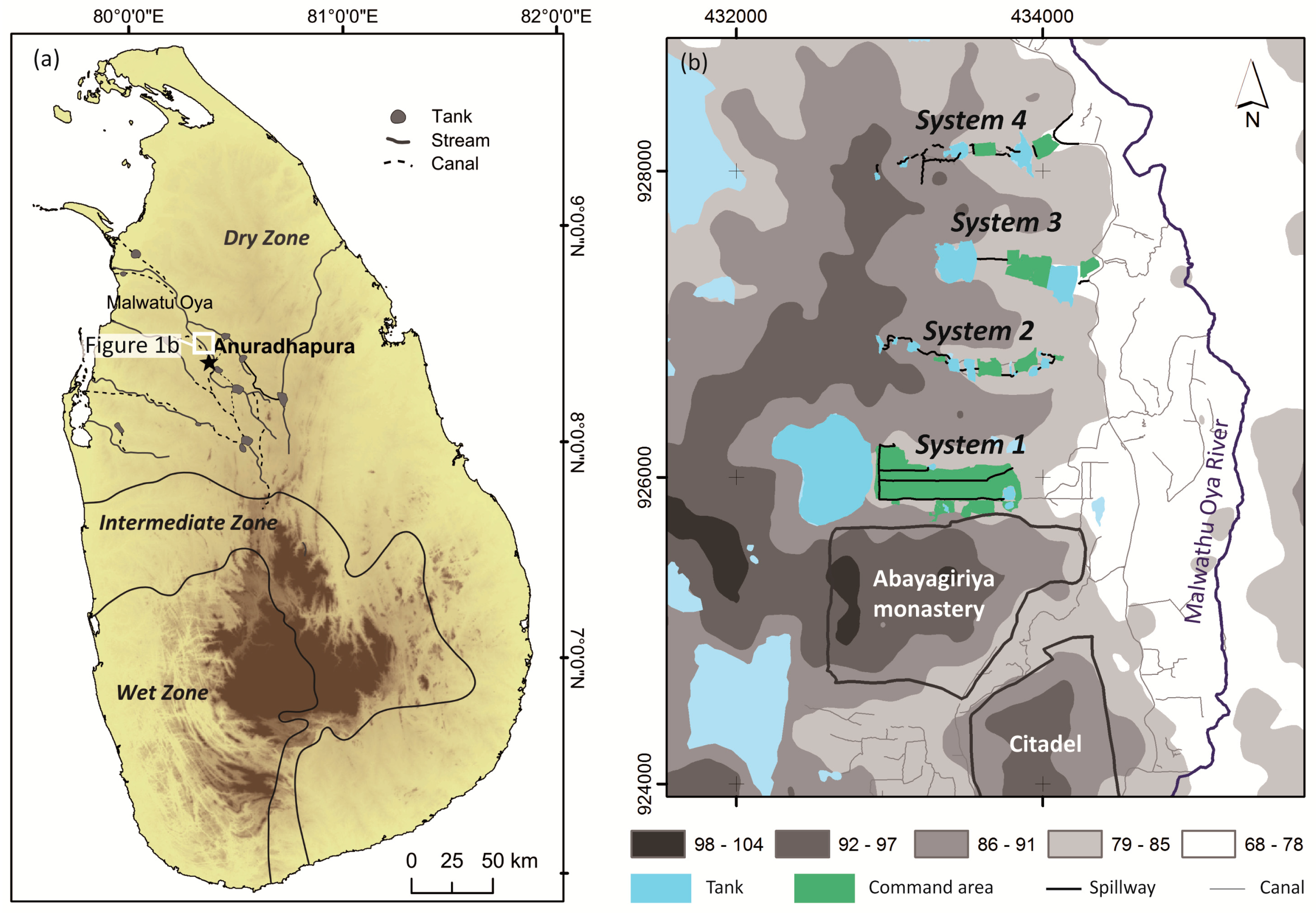
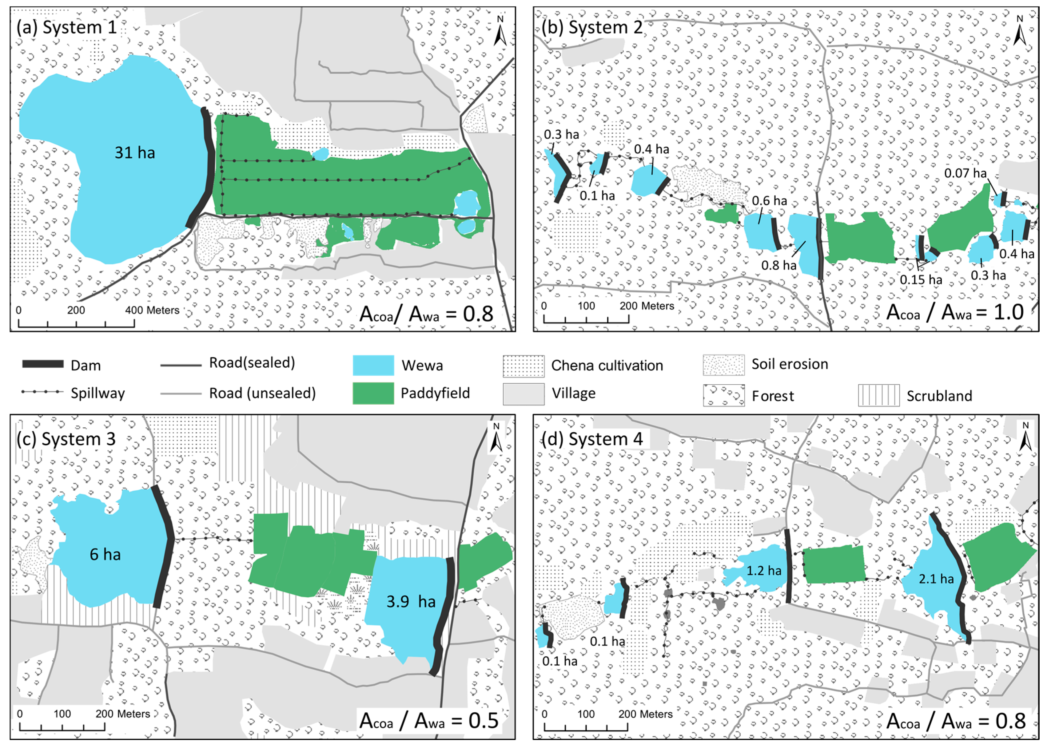
3.1. Micro-To-Minor-Scale Tank Cascade Systems North of Anuradhapura
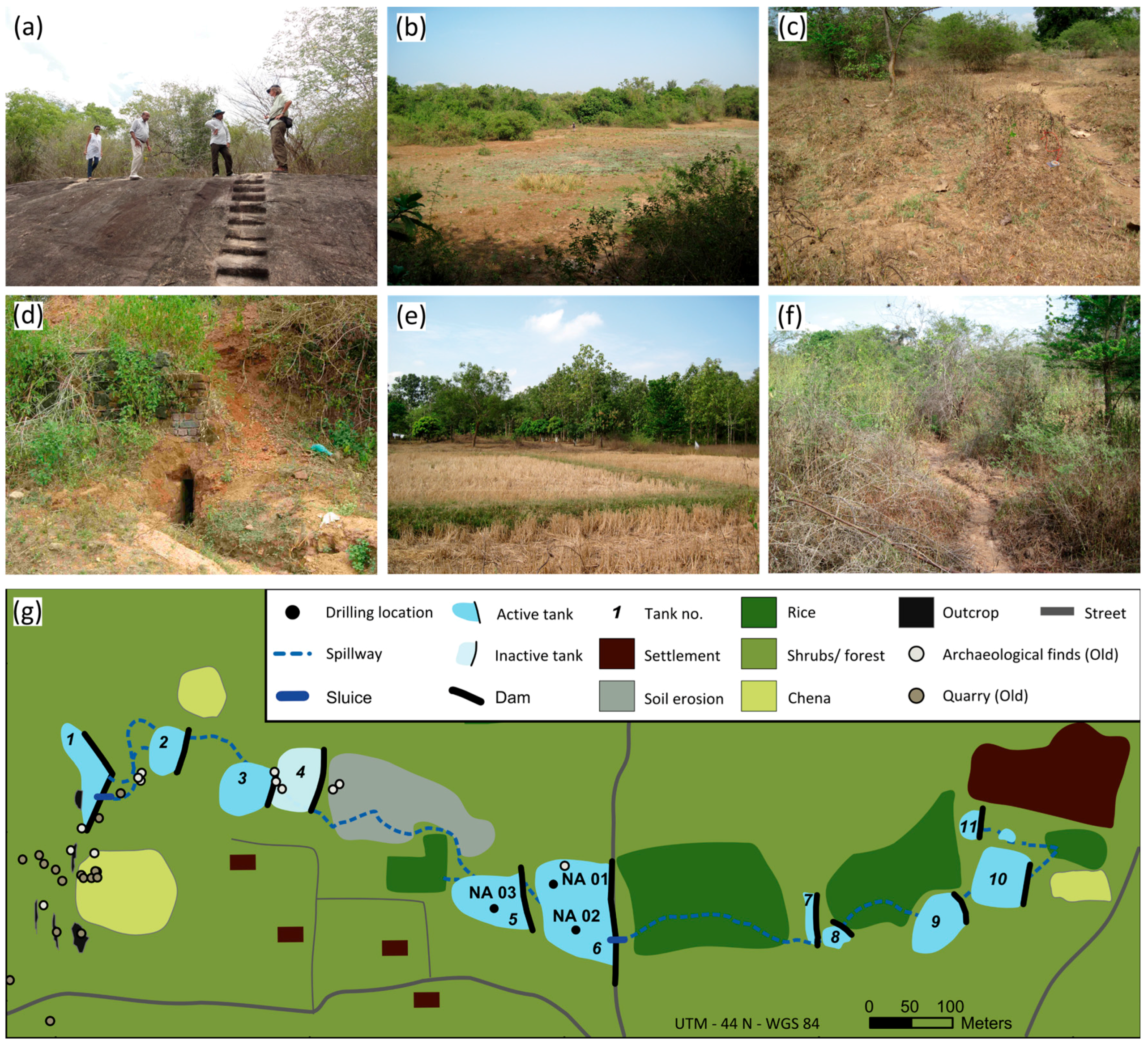
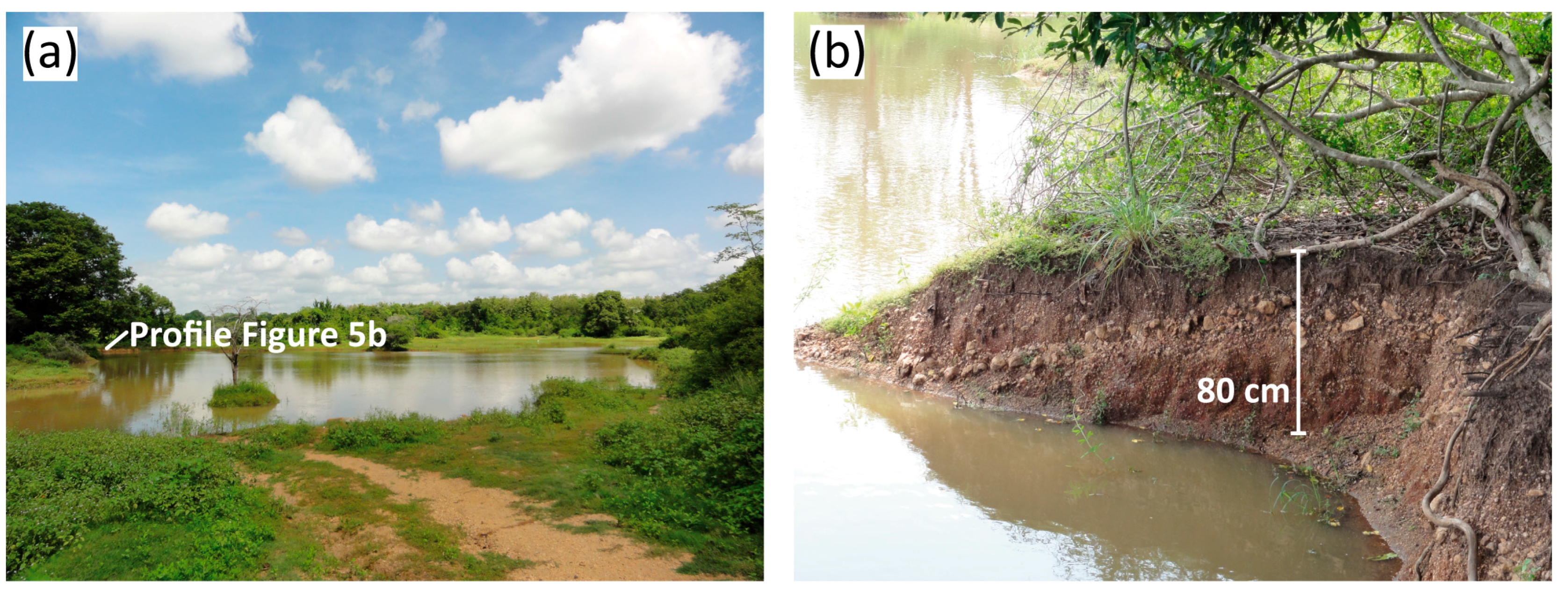
3.2. Sediment Characteristics of the Tanks in System 2
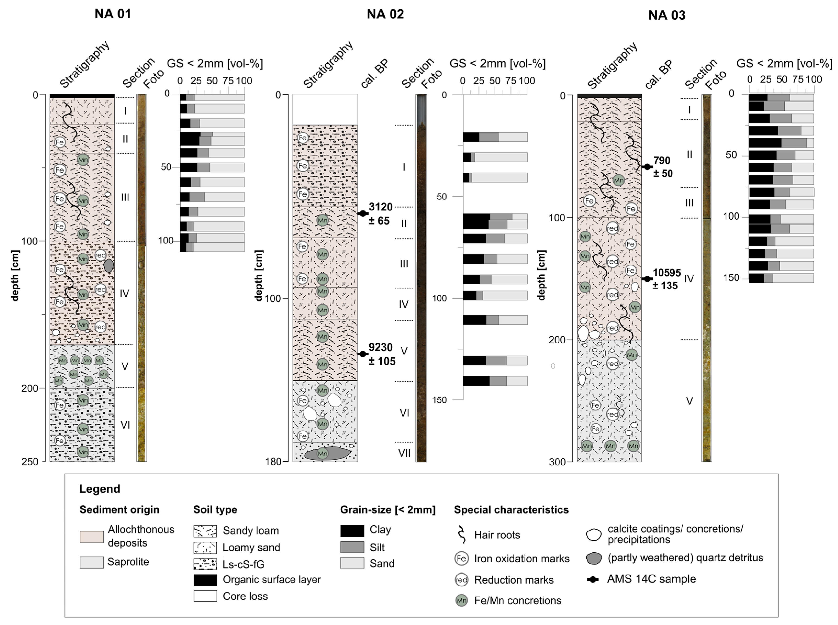
3.2.1. Sediment Profile NA01
3.2.2. Sediment Profile NA02
3.2.3. Sediment Profile NA03
3.2.4. AMS Radiocarbon Dating
4. Discussion
4.1. Layout of the Tank Cascade Systems
4.2. Sediment Characteristics
4.3. Geochronology
4.4. Synthesis
Acknowledgments
Author Contributions
Conflicts of Interest
References
- Withanachchi, S.S.; Köpke, S.; Withanachchi, C.R.; Pathiranage, R.; Ploeger, A. Water resource management in dry zonal paddy cultivation in Mahaweli River Basin, Sri Lanka: An analysis of spatial and temporal climate change impacts and traditional knowledge. Climate 2014, 2, 329–354. [Google Scholar] [CrossRef]
- Jayatilaka, C.J.; Sakthivadivel, R.; Shinogi, Y.; Makin, I.W.; Witharana, P. A simple water balance modelling approach for determining water availability in an irrigation tank cascade system. J. Hydrol. 2003, 273, 81–102. [Google Scholar] [CrossRef]
- Zubair, L. Modernisation of Sri Lanka’s Traditional Irrigation Systems and Sustainability. Sci. Technol. Soc. 2005, 10, 161–195. [Google Scholar] [CrossRef]
- Gilliland, K.; Simpson, I.A.; Adderley, W.P.; Burbidge, C.I.; Cresswell, A.J.; Sanderson, D.C.W.; Coningham, R.A.E.; Manuel, M.; Strickland, K.; et al. The dry tank: Development and disuse of water management infrastructure in the Anuradhapura hinterland, Sri Lanka. J. Archaeol. Sci. 2013, 40, 1012–1028. [Google Scholar] [CrossRef]
- Deraniyagala, S.U. The Prehistory of Sri Lanka, 2nd ed.Department of Archaeological Survey: Colombo, Sri Lanka, 1992.
- Dahdouh-Guebas, F.; Hettiarachchi, S.; Seen, D.L.; Batelaan, O.; Sooriyarachchi, S.; Jayatissa, L.P.; Koedam, N. Transitions in ancient inland freshwater resource management in Sri Lanka affect biota and human populations in and around coastal lagoons. Curr. Boil. 2005, 15, 579–586. [Google Scholar] [CrossRef] [PubMed]
- Leach, E.R. Village irrigation in the dry zone of Sri Lanka. In Irrigation and Agricultural Development in Asia: Perspectives from the Social Sciences; Cornell University Press: Ithaca, NY, USA, 1980; pp. 91–126. [Google Scholar]
- Dharmasena, P.B. Conservation farming practices for small reservoir watersheds: A case study from Sri Lanka. Agrofor. Syst. 1994, 28, 203–212. [Google Scholar] [CrossRef]
- Murray, F. Potential for Aquaculture in Community-Managed Irrigation Systems of the Dry-Zone, Sri Lanka: Impacts on Livelihoods of the Poor. Ph.D. Thesis, University of Stirling, Stirling, UK, 2004. [Google Scholar]
- Sakthivadivel, R.; Fernando, N.; Panabokke, C.R.; Wijayaratna, C.M. Nature of Small Tank Cascade Systems and a Framework for Rehabilitation of Tanks within Them; International Irrigation Management Institute (IIMI): Colombo, Sri Lanka, 1996. [Google Scholar]
- Amarasinghe, U.S.; Nguyen, T.T.T. Enhancing rural farmer income through fish production: Secondary use of water resources in Sri Lanka and elsewhere. In Success Stories in Asian Aquaculture; De Silva, S.S., Davy, F.B., Eds.; Springer: Dordrecht, The Netherlands, 2010; pp. 103–130. [Google Scholar]
- Jyothi, V.; Panabokke, C.R. Evolution of the indigenous village irrigation systems of Sri Lanka. Econ. Rev. 2010, 3–9. Available online: http://dl.nsf.ac.lk/bitstream/handle/1/14112/ER-36-%281-2%29_3.pdf?sequence=2 (accessed on 16 January 2017). [Google Scholar]
- Panabokke, C.R.; Sakthivadivel, R.; Weerasinghe, A.D. Evolution, Present Status and Issues Concerning Small Tank Systems in Sri Lanka; International Water Management Institute Colombo (IWMI): Colombo, Sri Lanka, 2002. [Google Scholar]
- Geekiyanage, N.; Pushpakumara, D.K.N.G. Ecology of ancient Tank Cascade Systems in island Sri Lanka. J. Mar. Isl. Cult. 2013, 2, 93–101. [Google Scholar] [CrossRef]
- Sinha, A.; Cannariato, K.G.; Stott, L.D.; Cheng, H.; Edwards, R.L.; Yadava, M.G.; Ramesh, R.; Singh, I.B. A 900-year (600 to 1500 ad) record of the Indian summer monsoon precipitation from the core monsoon zone of India. Geophys. Res. Lett. 2007, 34, 1–5. [Google Scholar] [CrossRef]
- Schütt, B.; Bebermeier, W.; Meister, J.; Withanachchi, C.R. Characterisation of the Rota Wewa tank cascade system in the vicinity of Anuradhapura, Sri Lanka. Die Erde J. Geogr. Soc. Berl. 2013, 144, 51–68. [Google Scholar]
- Russi, D.; ten Brink, P.; Farmer, A.; Badura, T.; Coates, D.; Förster, J.; Kumar, R.; Davidson, N. The Economics of Ecosystems and Biodiversity for Water and Wetlands; IEEP: London, UK; Brussels, Belgium, 2013. [Google Scholar]
- Gunnell, Y.; Krishnamurthy, A. Past and Present Status of Runoff Harvesting Systems in Dryland Peninsular India: A Critical Review. AMBIO J. Hum. Environ. 2003, 32, 320–324. [Google Scholar] [CrossRef]
- Panabokke, C.R.; Perera, A.P.G.R.L. Groundwater Resources of Sri Lanka; Water Resource Board: Colombo, Sri Lanka, 2005. [Google Scholar]
- National Climate Change Adaptation Strategy & Supporting Documents. Available online: http://www.climatechange.lk/adaptation/Index.html (accessed on 16 January 2017).
- Department of Census and Statistics—Sri Lanka: Population and Housing. Available online: http://www.statistics.gov.lk/page.asp?page=Population%20and%20Housing (accessed on 16 January 2017).
- Risberg, J.; Myrdal-Runebjer, E.; Miller, U. Sediment and soil characteristics and an evaluation of their applicability to the irrigation history in Sigiriya, Sri Lanka. J. Nord. Archaeol. Sci. 2002, 13, 27–42. [Google Scholar]
- Perera, L.S. The Sources of Ceylon History. In History of Ceylon; De Silva, K.M., Ed.; Ceylon University Press: Colombo, Sri Lanka, 1959; Volume 1, pp. 46–74. [Google Scholar]
- Lucero, L.J.; Fletcher, R.; Coningham, R. From ‘collapse’ to urban diaspora: The transformation of low-density, dispersed agrarian urbanism. Antiquity 2015, 89, 1139–1154. [Google Scholar] [CrossRef]
- Kottek, M.; Grieser, J.; Beck, C.; Rudolf, B.; Rubel, F. World map of the Köppen-Geiger climate classification updated. Meteorol. Z. 2006, 15, 259–263. [Google Scholar]
- Food and Agriculture Organization of the United Nations Clim. FAOClim World-Wide Agroclimatic Data, Version 2.01; Working Paper 5; Environment and Natural Resources; Food and Agriculture Organization of the United Nations (FAO): Rome, Italy, 2001. [Google Scholar]
- Panabokke, C.R.; Sakthivadivel, R.; Weerasinghe, A.D. Evolution, Present Status and Issues Concerning Small Tank Systems in Sri Lanka; International Water Management Institute (IWMI): Colombo, Sri Lanka, 2008. [Google Scholar]
- Somasekaram, T. The National Atlas of Sri Lanka; Sri Lanka Survey Department: Colombo, Sri Lanka, 1988; pp. 1–141.
- Panabokke, C.R.; Ariyaratne, B.R; Seneviratne, A.; Wijekoon, D.; Molle, F. Characterization and Monitoring of the Regolith Aquifer within four Selected Cascades (Sub-watersheds) of the Malala Oya Basin; International Water Management Institute: Colombo, Sri Lanka, 2007. [Google Scholar]
- Seneviratne, A. The Hydraulic Civilization of the Ancient Rajarata in Sri Lanka; International Water Management Institute (IWMI): Colombo, Sri Lanka, 1987. [Google Scholar]
- Ramsey, C.B.; Lee, S. Recent and planned developments of the program OxCal. Radiocarbon 2013, 55, 720–730. [Google Scholar] [CrossRef]
- Reimer, P.J.; Bard, E.; Bayliss, A.; Beck, J.W.; Blackwell, P.G.; Bronk Ramsey, C.; Buck, C.E.; Cheng, H.; Edwards, R.L.; Friedrich, M.; et al. IntCal13 and Marine13 radiocarbon age calibration curves 0–50,000 years cal BP. Radiocarbon 2013, 55, 1869–1887. [Google Scholar] [CrossRef]
- Mendis, D.T.; Abeywardana, N.; Withanachchi, C.R. An Archaeological Study to Identify the Ancient Settlement Pattern of Anuradhapura with Special Reference to the “Deegapasana” Rock Outcrop in Sri Lanka; Nihal Printers: Kurunegala, Sri Lanka, 2016; (original publication in Sinhala). [Google Scholar]
- Tennakoon, M.U.A. Rural Settlement and Land Use in North Central Sri Lanka. Ph.D. Thesis, Syracuse University, New York, NY, USA, 1974. [Google Scholar]
- Mahatantila, K.; Chandrajith, R.; Jayasena, H.A.H.; Ranawana, K.B. Spatial and temporal changes of hydrogeochemistry in ancient tank cascade systems in Sri Lanka: Evidence for a constructed wetland. Water Environ. J. 2008, 22, 17–24. [Google Scholar] [CrossRef]
- Chandrajith, R.; Mahatantila, K.; Jayasena, H.A.H.; Tobschall, H.J. Geochemical characteristics of sediments from a reservoir (tank) ecosystem in Sri Lanka. Paddy Water Environ. 2008, 6, 363–371. [Google Scholar] [CrossRef]
- Personal interview with a local villager, 23 September 2015 in the village Palugaswewa, Sri Lanka. Personal communication, 2015.
- Kingwell-Banham, E.; Fuller, D.Q. Shifting cultivators in South Asia: Expansion, marginalisation and specialisation over the long term. Quat. Int. 2012, 249, 84–95. [Google Scholar] [CrossRef]
- Hewawasam, T. Tropical weathering of apatite-bearing rocks of Sri Lanka: Major element behaviour and mineralogical changes. J. Geol. Soc. Sri Lanka 2013, 15, 31–46. [Google Scholar]
- Hewawasam, T.; von Blanckenburg, F.; Bouchez, J.; Dixon, J.L.; Schuessler, J.A.; Maekeler, R. Slow advance of the weathering front during deep, supply-limited saprolite formation in the tropical Highlands of Sri Lanka. Geochim. Cosmochim. Acta 2013, 118, 202–230. [Google Scholar] [CrossRef]
- Behrens, R.; Bouchez, J.; Schuessler, J.A.; Dultz, S.; Hewawasam, T.; von Blanckenburg, F. Mineralogical transformations set slow weathering rates in low-porosity metamorphic bedrock on mountain slopes in a tropical climate. Chem. Geol. 2015, 411, 283–298. [Google Scholar] [CrossRef]
- Dharmasena, P.B. Magnitude of sedimentation in village tanks. Trop. Agric. 1992, 148, 97–120. [Google Scholar]
- Thiemann, S.; Schütt, B.; Förch, G. Assessment of erosion and soil erosion processes—A case study from the Northern Ethiopian Highland. FWU Water Resour. Publ. 2005, 3, 173–185. [Google Scholar]
- Panabokke, C.R. Soil Science: The Soils of Ceylon and Use of Fertilizers; Ceylon Association for the Advancement of Science, Metro Printers: Colombo, Sri Lanka, 1967; pp. 1–151. [Google Scholar]
- Young, A. Tropical Soils and Soil Survey; Cambridge University Press: Cambridge, UK, 1980; Volume 9. [Google Scholar]
- Schütt, B. Zum holozänen Klimawandel der zentralen Iberischen Halbinsel. Relief Boden Palaeoklima 2004, 20, 1–347. [Google Scholar]
- Panabokke, C.R. A study of some soils in the Dry Zone of Ceylon. Soil Sci. 1959, 87, 67–74. [Google Scholar] [CrossRef]
- Schütt, B.; Busschert, R. Geomorphological reconstruction of palaeo Lake Ashengi Northern Ethiopia. In Proceedings of the Lake Abaya Research Symposium 2004, Siegen, Germany, 10–12 November 2004; Förch, G., Ed.; Forschungsinstitut Wasser und Umwelt (FWU): Siegen, Germany, 2005; pp. 51–57. [Google Scholar]
- Schütt, B. The chemistry of playa-lake-sediments as a tool for the reconstruction of Holocene environmental conditions—A case study from the central Ebro basin. In Paleoecology of Quaternary Drylands; Smykatz-Kloss, W., Felix-Henningsen, P., Eds.; Springer: Berlin/Heidelberg, Germany, 2004; pp. 5–30. [Google Scholar]
- Nambudiri, E.M.V.; Teller, J.T.; Last, W.M. Pre-quaternary microfossils—A guide to errors in radiocarbon dating. Geology 1980, 8, 123–126. [Google Scholar] [CrossRef]
- Wang, Y.; Amundson, R.; Trumbore, S. Radiocarbon dating of soil organic matter. Quat. Res. 1996, 45, 282–288. [Google Scholar] [CrossRef]
- Dreibrodt, S.; Lubos, C.; Hofmann, R.; MÜLler-ScheeßEl, N.; Richling, I.; Nelle, O.; Fuchs, M.; Rassmann, K.; KujundŽIĆ-VejzagiĆ, Z.; Bork, H.R.; et al. Holocene river and slope activity in the Visoko Basin, Bosnia-Herzegovina—Climate and land-use effects. J. Quat. Sci. 2013, 28, 559–570. [Google Scholar] [CrossRef]
- Grimm, E.C.; Jacobson, G.L. Late-Quaternary vegetation history of the eastern United States. In The Quaternary Period in the United States; Gillespie, A.R., Porter, S.C., Atwater, B.F., Eds.; Elsevier: Amsterdam, The Netherlands, 2003; Volume 1, pp. 381–402. [Google Scholar]
- Lowe, J.; Lowe, S.; Fowler, A.J.; Hedges, R.E.; Austin, T.J. Comparison of accelerator and radiometric radiocarbon measurements obtained from Late Devesian Lateglacial lake sediments from Llyn Gwernan, North Wales, UK. Boreas 1988, 17, 355–369. [Google Scholar] [CrossRef]
- Schütt, B.; Thiemann, S.; Weneclawiak, B. Deposition of modern fluvio-lacustrine sediments in Lake Abaya, south Ethiopia—A case study from the delta areas of Bilate River and Gidabo River, northern basin. Geomorph. NF 2005, 138, 131–151. [Google Scholar]
- Possnert, G. Radiocarbon dating by the accelerator technique. Nor. Archaeol. Rev. 1990, 23, 30–37. [Google Scholar] [CrossRef]
- Premathilake, R. Relationship of environmental changes in central Sri Lanka to possible prehistoric land-use and climate changes. Palaeogeogr. Palaeoclimatol. Palaeoecol. 2006, 240, 468–496. [Google Scholar] [CrossRef]
- Beckers, B.; Schütt, B. The chronology of ancient agricultural terraces in the environs of Petra. In Men on the Rocks: The Formation of Nabataean Petra; Mouton, M., Schmid, S., Eds.; Logos Verlag: Berlin, Germany, 2013; Volume 1, pp. 313–322. [Google Scholar]
- Beckers, B.; Schütt, B.; Tsukamoto, S.; Frechen, M. Age determination of Petra’s engineered landscape—Optically stimulated luminescence (OSL) and radiocarbon ages of runoff terrace systems in the Eastern Highlands of Jordan. J. Archaeol. Sci. 2013, 40, 333–348. [Google Scholar] [CrossRef]
- Coningham, R.; Gunawardhana, P. Anuradhapura: The Hinterland; Archaeopress for the Society for South Asian Studies: Oxford, UK, 2013. [Google Scholar]
- Brohier, R.L. Ancient Irrigation in Ceylon; Government Press: Colombo, Sri Lanka, 1934.
| Type | Water-Spread Area (ha) | Command Area (ha) | Maintenance | Seasonality | Number of Tanks in the Catchment of the Aruvi Aru River * |
|---|---|---|---|---|---|
| Major | >200 ha | >600 ha | State | Perennial | 11 |
| Medium | 50–200 ha | 80–60 ha | State | Perennial or seasonal | 74 |
| Minor | 1–50 ha | <80 ha | State and/or local communities | Mostly seasonal | 150 |
| Micro | 0.1–1 ha | <1 ha | Community or individual farmers | Perennial only with ground supply | n.a. |
| Sediment Profile | UTM * East | UTM * North | Depth (cm) |
|---|---|---|---|
| (44N) | |||
| NA01 | 433,520 | 926,767 | 250 |
| NA02 | 433,547 | 926,702 | 180 |
| NA03 | 433,458 | 926,740 | 300 |
| Unit | Depth (cm b. s.) | Sediment Character |
|---|---|---|
| 0–1 | litter, undecomposed plant remains | |
| I * | 1–20 | loamy sand with sub-angular fine gravel, dark yellowish brown (10 YR 4/6), moderately rooted (hair roots), dry, unconsolidated, gradual change to |
| II * | 20–40 | transitional horizon between units I and II, gradual change to |
| III * | 40–100 | sandy loam, dark brown (7.5 YR 3/4), weakly rooted (hair roots), fairly dry, highly compacted, mottled sesquioxide oxidation marks, scattered calcareous precipitations and coatings, scattered Fe/Mn concretions (small), diffuse change to |
| IV * | 100–170 | angular-shaped gravel in sandy loamy-matrix, olive brown (2.5 YR 4/4, reduced), isolated hair roots, moist, highly compacted, mottled sesquioxide oxidation marks, scattered Fe/Mn concretions, scattered calcareous precipitations, diffuse change to |
| V ** | 170–210 | alternating layers of sandy and loamy material, sand: yellow (10 YR 8/6) to very pale brown (10 YR 8/4), clay: dark yellowish brown (10 YR 4/6); not rooted, moist, highly compacted, very high concentration of small sesquioxide concretions at depths from 178 to 181 cm, scattered calcareous precipitations, diffuse change to |
| VI ** | 210–250 | sandy/gravely (angular-shaped), very crumbly, yellowish/white in color, not rooted, moist, highly compacted, scattered Fe/Mn concretions, scattered sesquioxide oxidation marks |
| Unit | Depth (cm b. s.) | Sediment Character |
|---|---|---|
| 0–18 | core loss | |
| I * | 18–55 | fine gravel in sandy matrix; structure-less; very weakly compacted; colored gradation from dark greyish brown (10 YR 4/2) over dark brown (10 YR 4/4) to dark yellowish brown (10 YR 3/3); dry but increasing moisture with greater depth, strong sesquioxide oxidation marks; weakly rooted (hair roots), clear change to |
| II * | 55–70 | sandy loam; very dark brown (10 YR 2/2); not rooted; moist; highly compacted, scattered Fe/Mn concretions, diffuse change to |
| III * | 70–93 | ditto unit II; mottled sesquioxide oxidation marks; scattered Fe/Mn concretions, diffuse change to |
| IV * | 93–110 | sandy loam; dark yellowish brown (10 YR 4/4); not rooted; moist; highly compacted; weak sesquioxide oxidation marks, diffuse change to |
| V * | 110–140 | sandy loam (getting coarser with increasing depth); dark yellowish brown (10 YR 3/6); not rooted; moist; highly compacted; yellow streaks of sesquioxide oxidation marks; scattered Fe/Mn concretions (spherical, Ø 1 cm), diffuse change to |
| VI ** | 140–170 | coarse sandy loam (becoming coarser with increasing depth); dark yellowish brown (10 YR 3/6); not rooted; moist; highly compacted; soft calcium carbonate precipitations and coatings (light brownish grey, 10 YR 6/3, very crumbly); scattered small Fe/Mn concretions, diffuse change to |
| VII ** | 170–180 | middle and coarse sand with a small amount of angular-shaped fine gravel; very crumbly; dark yellowish brown (10 YR 4/6); decrease of calcium carbonate precipitations; increase of Fe/Mn concretions; not rooted; moist; highly compacted; partly weathered quartz detritus from 175 to 180 cm depth |
| Unit | Depth (cm b. s.) | Sediment Character |
|---|---|---|
| 0–2 | litter, organic overlay | |
| I * | 2–21 | loamy (coarse) sand with small contents of fine gravel; dark yellowish brown (10 YR 4/4); moderately rooted (hair roots); dry; highly compacted, gradual change to |
| II * | 21–75 | sandy loam with small contents of fine gravel; dark greyish brown (10 YR 3/2); weakly rooted (hair roots); scattered Fe/Mn concretions (spherical, <Ø 0.5 cm); dry; highly compacted, diffuse change to |
| III * | 75–100 | coarse sandy loam with fine gavel; very dark greyish brown (10 YR 3/2); weakly rooted; dry; very highly compacted; mottled sesquioxide-oxidation marks; many Fe/Mn concretions, clear change to |
| IV * | 100–200 | coarse sandy loam; olive brown (2.5 YR 4/4); weakly rooted (hair roots); moist; highly compacted; scattered Fe/Mn concretions (up to Ø 1 cm); sesquioxide-oxidation marks; soft diffuse calcium carbonate precipitations, diffuse change to |
| V ** | 200–300 | mixed horizon of layers of coarse sandy loam with fine gravel and sand with sesquioxide oxidation marks; sandy loam: olive brown (2.5 YR 4/4), sand: yellow (10 YR 8/6) & very pale brown (10 YR 8/4); very weakly rooted (hair roots); moist; moderate to highly compacted; scattered Fe/Mn concretions; soft diffuse calcium carbonate precipitations |
| Sediment Profile | Lab-Code | Sampling Depth (cm b. s.) | Uncalibrated Age (a BP) * | Calibrated Age (cal a BP, 2σ) | Calibrated Age (cal a BCE/CE, 2σ) |
|---|---|---|---|---|---|
| NA02 | Poz-40251 | 59–60 | 2960 ± 40 | 3120 ± 65 | 1170 ± 65 BCE |
| NA02 | Poz-40252 | 147–149 | 8250 ± 70 | 9230 ± 105 | 7285 ± 105 BCE |
| NA03 | Poz-37935 | 57–58 | 870 ± 30 | 790 ± 50 | 1160 ± 50 CE |
| NA03 | Poz-40249 | 146–147 | 9370 ± 80 | 10595 ± 135 | 8645 ± 135 BCE |
© 2017 by the authors. Licensee MDPI, Basel, Switzerland. This article is an open access article distributed under the terms and conditions of the Creative Commons Attribution (CC BY) license ( http://creativecommons.org/licenses/by/4.0/).
Share and Cite
Bebermeier, W.; Meister, J.; Withanachchi, C.R.; Middelhaufe, I.; Schütt, B. Tank Cascade Systems as a Sustainable Measure of Watershed Management in South Asia. Water 2017, 9, 231. https://doi.org/10.3390/w9030231
Bebermeier W, Meister J, Withanachchi CR, Middelhaufe I, Schütt B. Tank Cascade Systems as a Sustainable Measure of Watershed Management in South Asia. Water. 2017; 9(3):231. https://doi.org/10.3390/w9030231
Chicago/Turabian StyleBebermeier, Wiebke, Julia Meister, Chandana Rohana Withanachchi, Ingo Middelhaufe, and Brigitta Schütt. 2017. "Tank Cascade Systems as a Sustainable Measure of Watershed Management in South Asia" Water 9, no. 3: 231. https://doi.org/10.3390/w9030231
APA StyleBebermeier, W., Meister, J., Withanachchi, C. R., Middelhaufe, I., & Schütt, B. (2017). Tank Cascade Systems as a Sustainable Measure of Watershed Management in South Asia. Water, 9(3), 231. https://doi.org/10.3390/w9030231


