Article

Modeling Rainfall-Runoff Response to Land Use and Land Cover Change in Rwanda (1990–2016)

1
College of Life Science, Shihezi University, Shihezi 832003, China
2
State Key Laboratory of Desert and Oasis Ecology, Xinjiang Institute of Ecology and Geography, Chinese Academy of Sciences, Urumqi 830011, China
3
University of Chinese Academy of Sciences, Beijing 100049, China
4
Faculty of Environmental Studies, University of Lay Adventists of Kigali, P.O. Box 6392 Kigali, Rwanda
5
Joint Research Center for Natural Resources and Environment in East Africa, P.O. Box 6392 Kigali, Rwanda
6
Ministry of Disaster Management and Refugee Affairs, P.O. Box 4386 Kigali, Rwanda
*
Author to whom correspondence should be addressed.
Water 2017, 9(2), 147; https://doi.org/10.3390/w9020147
Submission received: 29 December 2016 / Revised: 7 February 2017 / Accepted: 14 February 2017 / Published: 22 February 2017

Abstract

:
Stormwater runoff poses serious environmental problems and public health issues in Rwanda, a tropical country that is increasingly suffering from severe floods, landslides, soil erosion and water pollution. Using the WetSpa Extension model, this study assessed the changes in rainfall runoff depth in Rwanda from 1990 to 2016 in response to precipitation and land use changes. Our results show that Rwanda has experienced a significant conversion of natural forest and grassland to cropland and built-up areas. During the period 1990–2016, 7090.02 km2 (64.5%) and 1715.26 km2 (32.1%) of forest and grassland covers were lost, respectively, while the cropland and built-up areas increased by 135.3% (8503.75 km2) and 304.3% (355.02 km2), respectively. According to our estimates, the land use change effect resulted in a national mean runoff depth increase of 2.33 mm/year (0.38%). Although precipitation change affected the inter-annual fluctuation of runoff, the long-term trend of runoff was dominated by land use change. The top five districts that experienced the annual runoff depth increase (all >3.8 mm/year) are Rubavu, Nyabihu, Ngororero, Gakenke, and Musanze. Their annual runoff depths increased at a rate of >3.8 mm/year during the past 27 years, due to severe deforestation (ranging from 62% to 85%) and cropland expansion (ranging from 123% to 293%). These areas require high priority in runoff control using terracing in croplands and rainwater harvesting systems such as dam/reservoirs, percolation tanks, storage tanks, etc. The wet season runoff was three times higher than the dry season runoff in Rwanda; appropriate rainwater management and reservation could provide valuable irrigation water for the dry season or drought years (late rainfall onsets or early rainfall cessations). It was estimated that a reservation of 30.5% (3.99 km3) of the runoff in the wet season could meet the cropland irrigation water gap during the dry season in 2016.

1. Introduction

Nowadays, deforestation and natural grasslands conversion for urban expansion and agricultural intensification due to rapid population growth have become a critical environmental issue [1,2,3]. Urbanization expansion increases impervious covers that reduce infiltration capacity, leading to downstream flooding, stream bank erosion, increased turbidity (muddiness created by stirred up sediment) from erosion, habitat destruction, combined sewer overflows, infrastructure damage, contaminated streams, rivers and coastal water [1,4]. For instance, in the Zhujiang Delta of southern China, where dramatic urban growth has occurred over the past two decades, the rampant urban growth has created severe problems in water resources management and this resulted in a 8.10 mm increase in annual runoff depth during the 1989–1997 period [4].
With a population density of 470.6 people per km2, Rwanda is one of the most densely-populated countries in Africa (in comparison with the mean population densities of the world and Eastern Africa which were 56.5 people per km2 and 59.2 people per km2, respectively) as of 1 July 2015 [5,6]. Rwanda’s population pressure has caused land resource scarcity, leading to an average annual decrease of 1.6% in forest area during the period 1960–2000 [7]. Generally, a healthy forest acts like a sponge to soak up the rain, holding the water and filtering it before it makes its way to nearby streams, lakes, and rivers [8]. Vegetation removal to prepare land for agriculture leaves soil susceptible to a massive increase in muddy agricultural runoff. This reduces the fertility of the soil, rendering it unsuitable for agricultural purposes, as well as transporting large volumes of nitrogen, phosphorus, and sediments to streams which can lead to various negative impacts such as increased sedimentation, turbidity, eutrophication and coastal hypoxia of wetlands and rivers [9,10,11]. Around 80% of the pollution in seas and oceans comes from land-based activities [12]. Intensive stormwater runoff under uncontrolled land cover and land use dynamics has direct negative impacts such as landslides, floods, erosion, and water pollution [13,14,15]. A typical example of stormwater runoff effect on water qualiy is the Nyabarongo river system that drains about 33% of the total Rwanda area, which is constantly polluted by soil erosions. This river contains high turbidity of 737.28 ± 571.03 Nephelometric Turbidity Units (NTU) and Nitrate-Nitrogen (NO3-N) of 28.79 ± 20.94 mg/L compared to 1 NTU and 11 NO3-N which have been set as the standard limits by the World Health Organization (WHO) drinking water guideline [16]. Stormwater runoff-related disasters continuously lead to the loss of colossal amounts money. In Rwanda, the estimated total economic loss of the 2012 wet season flooding including agricultural loss, livestock loss and infrastructure loss (replacement and economic cost) was estimated at 58,322,907,201 RWF (Rwandan Franc) (approximately 64,298,800 €) which represented about 1.4% of the Rwanda’s overall gross domestic product GDP of 2011/2012 [17]. In Rwanda, landslide disasters caused by stormwater runoff killed 74 people in 2010, injured 22 people and over 573 houses were destroyed [18]. Again, between 2011 and 2013, flood hazards killed 38 people, injured 40 people, destroyed 878 houses and 746 ha of land were affected [18]. These natural and human-induced hazards might be exacerbated by the rising population pressure where about 83.4% of Rwanda’s population primarily depends on a subsistence rainfed agriculture practiced on hill slopes without fallow due to land resource scarcity [6,19].
Rapid urban expansion and agricultural intensification on a highly vulnerable terrain of Rwanda with a mean steep slope of 22% and mean rainfall intensity of 1116 mm/year (1990–2016), without proper land use management strategies, can increase the volume of rainwater runoff and its associated impacts. Based on the fact that there is a critical gap in hydrological and climatic data in Rwanda, both in time and space [20], and considering the environmental problems indicated above, the present study assesses trends in (1) land use and land cover; (2) rainfall runoff depth; and (3) runoff volumes at National and District level in Rwanda (1990–2016), using the WetSpa Extension model. WetSpa is a Geographical Information System (GIS)-based hydrologic model [21], that has been developed for flood prediction and watershed management [21,22]. The input datasets utilized in our study include soil texture, land cover and land use, elevation, and rainfall intensity. Hydrological modelling is a well-known technique of hydrologic system investigation for both research hydrologists and practicing water resources engineers involved in the planning and development of an integrated approach for water resources management [23]. Remote sensing has increasingly become a viable data source to augment the conventional hydrological rainfall runoff simulation, especially for inaccessible regions or complex terrains [24,25]. Hydrological models are typically structured in characterizing watershed conditions such as topography, soil type, land use, drainage density, degree of soil saturation, and rainfall properties, for which it is advantageous to use the data currently available in GIS format. Advantages of rainfall runoff modeling using the WetSpa Extension model include the use of freely worldwide available geospatial data (soil texture, land cover/use, elevation, and rainfall intensity) and good model structure that allows the estimation of runoff depth on a large-scale area with complex catchments [21].

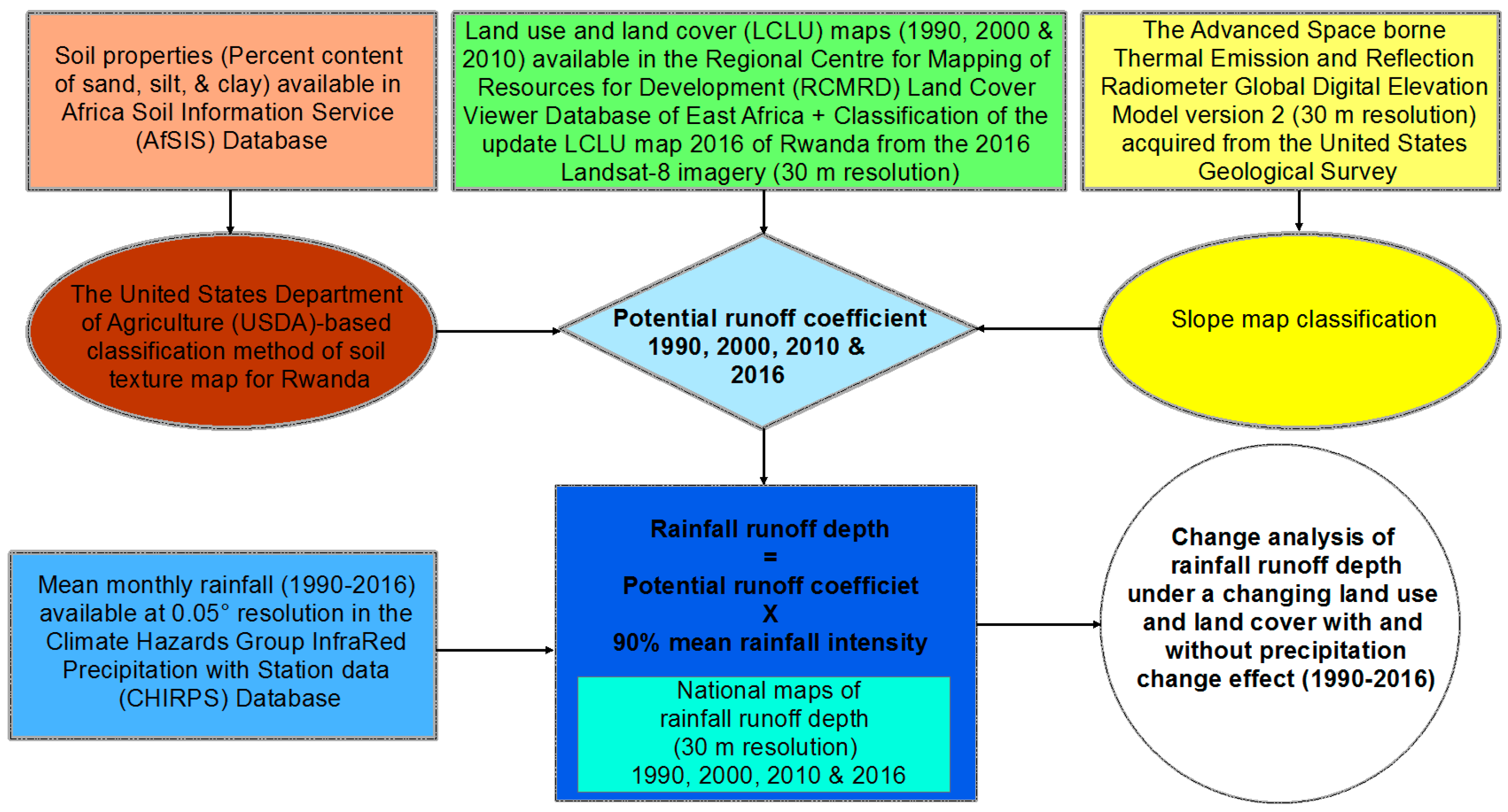
2. Materials and Methods

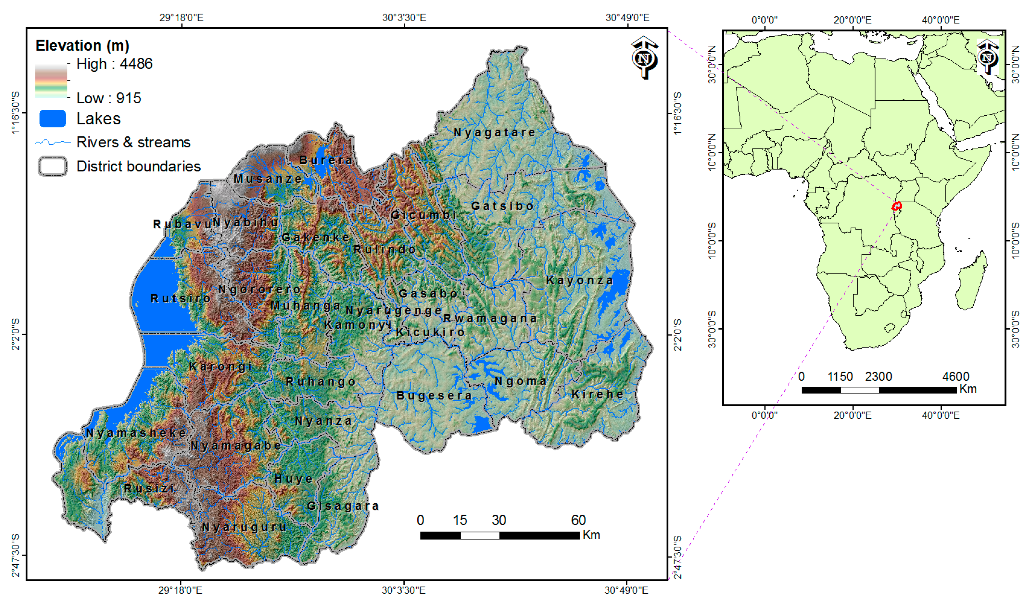
2.1. Description of the Study Area

Rwanda is a tropical landlocked country with a land surface area of about 25,364.52 km2 [26], located between 1°–3° south latitude and 28°–31° east longitude. The country shares borders with Uganda to the north, Burundi to the south, Tanzania to the east and the Democratic Republic of the Congo (DRC) to the west. Rwanda has a steep topography, lying at an altitude ranging between 915 m and 4486 m (Figure 1). The country experiences a tropical temperate climate, with the mean air temperature ranging between 16 °C and 20 °C [27]; two wet rainy seasons per year (March–May and September–December) and two dry seasons (January–February and June–August) [28]. The long-term average annual rainfall intensity ranges between 805 mm and 1725 mm with a general mean of 1116 mm/year during the period 1990–2016.
The estimated Rwandan population was about 12 million in 2015 with 28.81% urban population [29]. This population is expected to be around 17 million in 2030 with 41.55% urban population. In 2050, the population will be more than 25 million, while 52% of the total population will be residing in urban areas [29]. Rwanda is characterized by a strongly heterogeneous landscape, with very different terrain features over the 30 administrative districts as shown in Figure 1. High mountains up to 4.5 km above sea level sit in the west and northwest part of the country, including the Congo Nile Ridge, the Volcanic Range and the Buberuka highlands. The plains are found in the eastern part of the country, including the eastern savanna, the eastern plateau, the central plateau and the Bugesera-Mayaga. A large wetland reservation in the Akagera National Park is found in the northeast of the country [6]. Based on the statistical analysis computed from the geospatial lithological and soil types acquired from the Soil and Terrain Database of Central Africa-DR of Congo, Burundi and Rwanda [30], the Rwandan soils are composed by fragile soils (a physic-chemical alteration of basic schistose, granite, basic igneous rock, and so on). The underlying geology consists of the Acrisols (47.5%), Ferralsols (17.5%), Regosols (13%), Andosols (5%), Histosols (4.1%) and Cambisols (3.2%), Vertisols (1.8%), Greysols (1.5%), Nitosols (0.4%), and water bodies cover the remaining 6%.

2.2. Model Description

Figure 2 illustrates the conceptual framework established for modeling the trend in runoff depth in Rwanda (1990–2016).
In Wetspa, runoff volume and runoff depth were estimated based on the potential runoff coefficient per pixel (Figure 3) at 30 m resolution and the long-term mean rainfall intensity at 30 m resolution (Figure 4) using Equations (1) and (2) developped by Schueler (1987) [31,32]. These equations were computed using the raster calculator tool of the ArcGIS software version 10.2 (Environmental Systems Research Institute (Esri) Inc., Redlands, CA, USA) [21,22].
R v   =   R d   ×   A   ×   10
R   =   P   ×   P j   ×   C 0
where R v = runoff volume (m3) in the area of interest; R d = average runoff depth (mm) in the area of interest; A = area of interest (ha); 10 is a unit conversion constant; P = precipitation for time period of interest (mm); P j = Fraction of annual rainfall that produces runoff (usually 90%). The constant P j was introduced to recognise that many small storms do not produce runoff [31,32]; and C 0 = Potential runoff coefficient, which is the ratio of runoff volume to rainfall volume in a grid pixel or catchment. WetSpa estimates C 0 under varying land use, soil texture, slope, rainfall intensity and antecedent soil moisture conditions according to Table 1. These variables act independently but also interact in their effect on the runoff coefficient [21]. Table 1 was built based on the potential runoff coefficients recommended in the WetSpa user manual [21]. Based on the LCLU maps (Figure 5), soil textural map (Figure 6d), and slope map (Figure 7) for Rwanda (see the following section), we developed the Maps of the Potential runoff coefficients for Rwanda (Figure 3). The potential runoff coefficients for built-up land that cannot be 100% impervious (Table 1) were estimated by the linear Equation (3) [21].
C u   =   IMP   +   ( 1     IMP )   C g r a s s
where, C u and C g r a s s are the potential runoff coefficient for urban and grass areas, respectively and IMP is the proportion of impervious area which is equal to 50% for built-up land [21].

2.3. Model Inputs and Scenario Design

Model inputs include the rainfall intensity, area’s land use, soil texture, and slope [21,22]. All data were geo-referenced and resampled to the same spatial resolution of 30 m in this study. Except the land cover and land use (LCLU) maps and Advanced Spaceborne Thermal Emission and Reflection Radiometer (ASTER) Global Digital Elevation Model (GDEM) available with 30 m resolution, rainfall and soil property datasets were obtained with 250 m resolution. In order to produce the maps of rainfall runoff at a high resolution of 30 m, the data with 250 m resolution were first converted to point shapefiles. Then, these points were interpolated at 30 m resolution using an inverse distance weighting (IDW) tool available in the Interpolation toolset of ArcGIS Map 10.2. Statistical analysis was computed using the Zonal Statistics as the Table Tool available in the Spatial Analyst Zonal Toolset of the ArcGIS Map 10.2 (ArcGIS software version 10.2, Environmental Systems Research Institute (Esri) Inc., Redlands, CA, USA). This study conducted two numeric experiments: In the first experiment, the OVERALL scenario, the model was driven by the effects of land cover/use and mean annual precipitation changes for the period 1990–2016. This is the “business as usual” scenario, aiming to assess the runoff dynamic in Rwanda. In the second experiment, the LUC-ONLY scenario, the climate drivers were held constant using the long-term mean annual precipitation for the period 1990–2016 which remains with a changing land cover/use from year to year. This experiment was used to isolate the effects of land cover/use and climate changes.

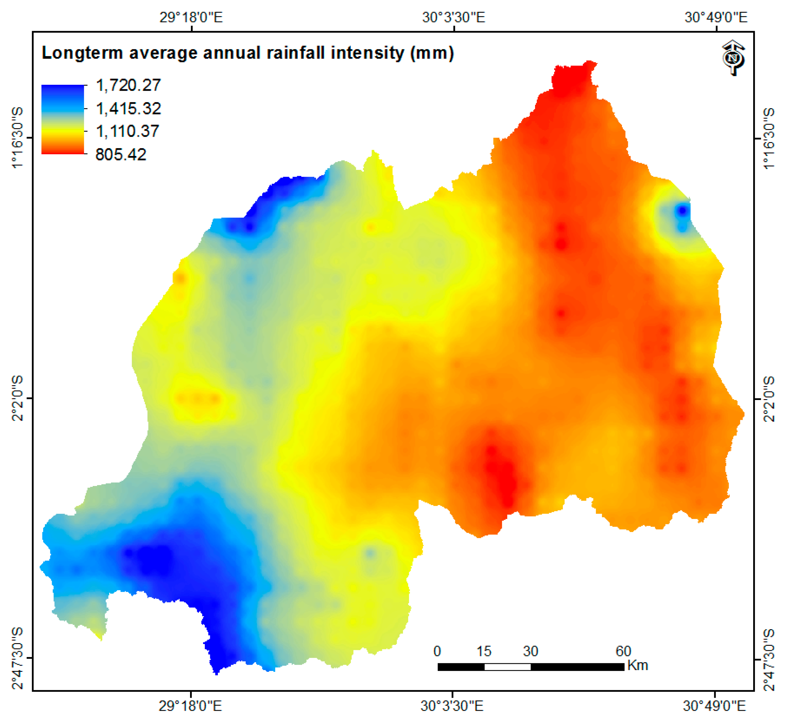
2.3.1. Long-Term Mean Annual Rainfall Intensity

The present study estimated the long-term mean annual precipitation (Figure 4) for the period of 27 years (1990–2016) using monthly average precipitation provided by the Climate Hazards Group InfraRed Precipitation with Station data (CHIRPS). CHIRPS incorporates 0.05° resolution satellite imagery with in situ station data [33].

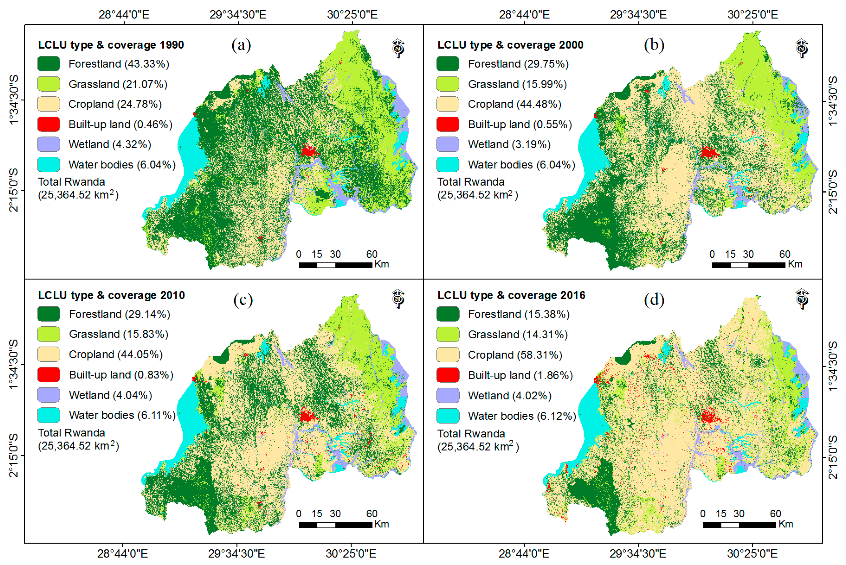
2.3.2. Developing Land Use and Land Cover Maps for Rwanda

To assess the trend in rainwater runoff within the context of a changing land use and land cover (LCLU) in Rwanda, it is necessary to have historical LCLU information. LCLU maps of Rwanda for three periods (1990, 2000, and 2010) with 30 m resolution (Figure 5) were acquired from the Regional Centre for Mapping of Resources for Development (RCMRD) Land Cover Viewer database of East Africa [34]. The updated LCLU map 2016 for Rwanda (Figure 5d) was obtained through image classification of the 2016 Landsat-8 imagery delivered by the United States Geological Survey (USGS) global visualization [35] using the supervised maximum likelihood classification method [36] in ENVI software version 5.2 (Exelis Visual Information Solutions, Inc., a subsidiary of Harris Corporation, Boulder, CO, USA) [37]. The resultant LCLU map with a 30 m resolution was classified referring to the previous RCMRD LCLU maps and the USGS classification system category one [38]. Referring to the accuracy assessment methods [39,40] and the rule of thumb [41], 60 random points were collected for each land cover/use category using the primary Landsat-8 images used to generate the classified image. The results presented in an error matrix table (Table 2) show that classification accuracies of the LCLU map for Rwanda 2016 are in acceptable ranges compared to the recommended overall accuracy of at least 85% [38,42,43] and 70% for each land cover/use category [42]. Kappa coefficient is a good indicator of accuracy that measures the overall agreement between reference data and the classified thematic map [37,44]. A Kappa coefficient of 84.3% for LCLU classification indicates a good accuracy compared to the generally acceptable Kappa coefficient of 75% [45].

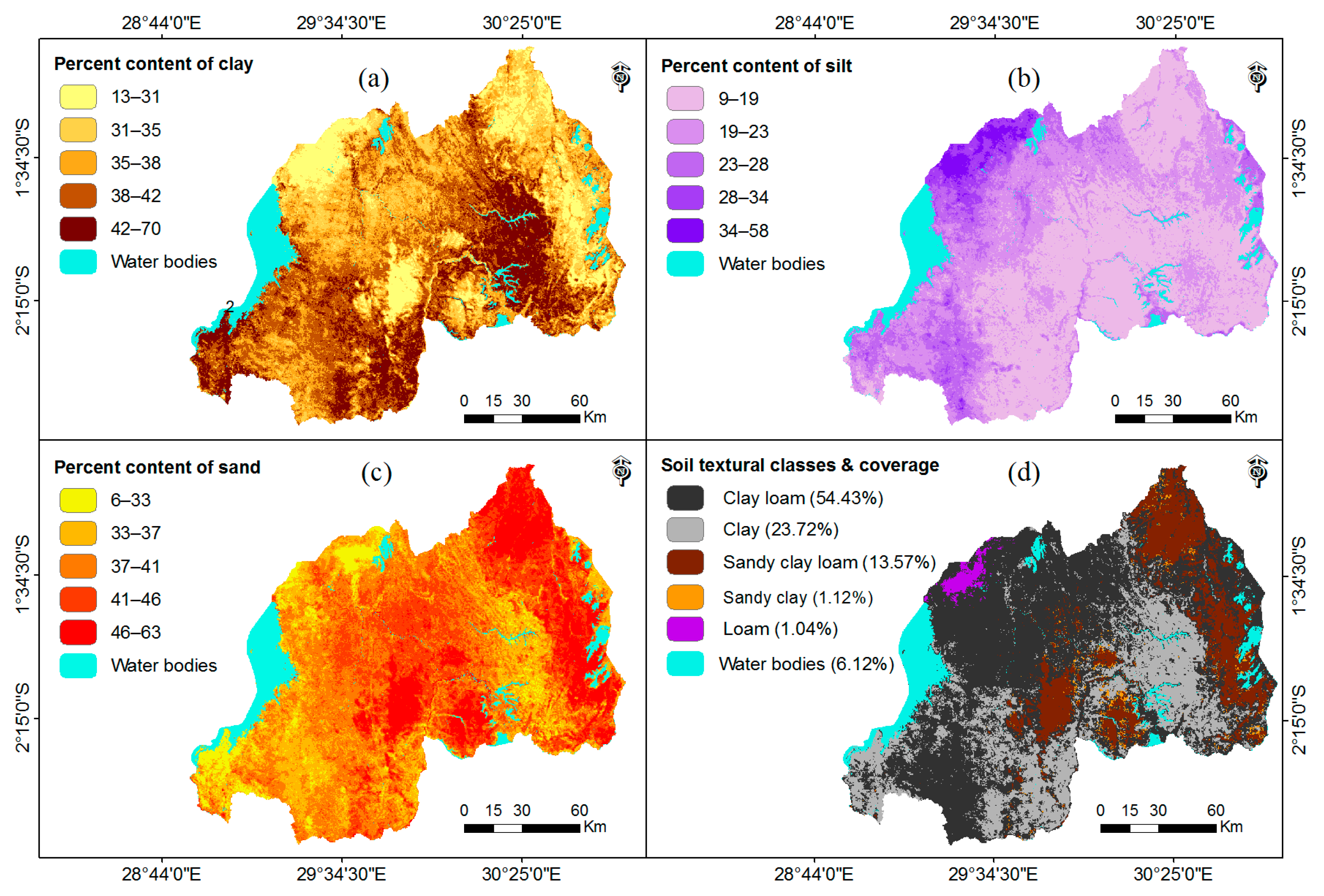
2.3.3. Soil Textural Classification Map
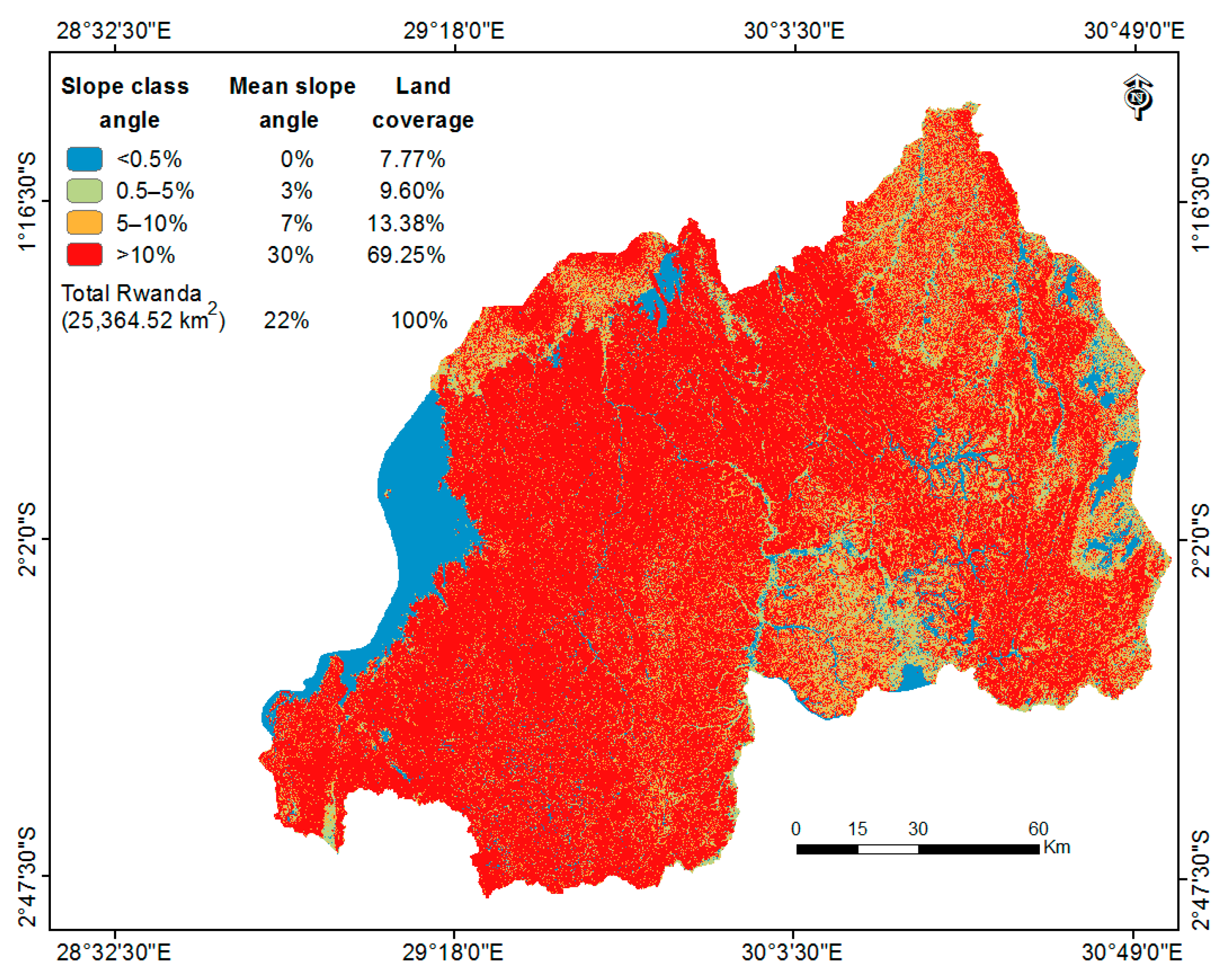
The soil layers of clay, silt and sand fractions for Rwanda (Figure 6) with 30 m resolution were obtained from the Africa Soil Information Service (AfSIS) available with a spatial resolution at 250 m of 250 m [46] and they were used in this study to derive the soil textural map of Rwanda (Figure 6d), as shown in the following Table 3 adapted from the soil texture triangle classification system developed by the United States Department of Agriculture (USDA). It is built considering its percentage of clay, silt and sand, ranging from the fine textures (clay), through the intermediate textures (loam); and the coarser textures (sand) [21,47].

2.3.4. Slope Map

The map of slope percent (Figure 7) with four necessary classes for potential runoff estimation [21], was derived from the Advanced Space borne Thermal Emission and Reflection Radiometer (ASTER) Global Digital Elevation Model (GDEM) version 2 (30 m resolution) provided by the United States Geological Survey (U.S.G.S.) using the hydrology tool available in the Spatial Analyst extension tool of ArcMap 10.2 (Environmental Systems Research Institute (Esri) Inc., Redlands, CA, USA) [48].

2.4. Wet Season’s Rainwater Runoff Reservation for Irrigation

Rwandan farmers rely solely on the rainfall for irrigation, which constitutes a major hindrance to the development of agriculture, in the sense that crop productivity drops in dry seasons and drought years (late rainfall onsets or early rainfall cessations) [49]. In this respect, using the already known water requirements for Rwanda (12,500 m3/ha/year) [50], the present study assessed how wet seasons’ rainwater runoff reservation could provide a valuable source of water for irrigation during the dry seasons. First, the rainwater surplus was calculated as the difference between the available long-term mean rainwater during wet seasons and the quantity of water required for irrigation, considering the 2016 cropland area (14,787.52 km2) (approximately 58.30% of the total land surface) [28]. Afterwards, we estimated the rainwater runoff which could be harvested to close the gap in water requirement for irrigating the total cropland during the 5 months of the dry season in Rwanda; the deficit in irrigation water requirement during dry seasons has been calculated by subtracting the available rainwater quantity from the required water volume to irrigate croplands during the dry seasons (Table 7).

3. Results

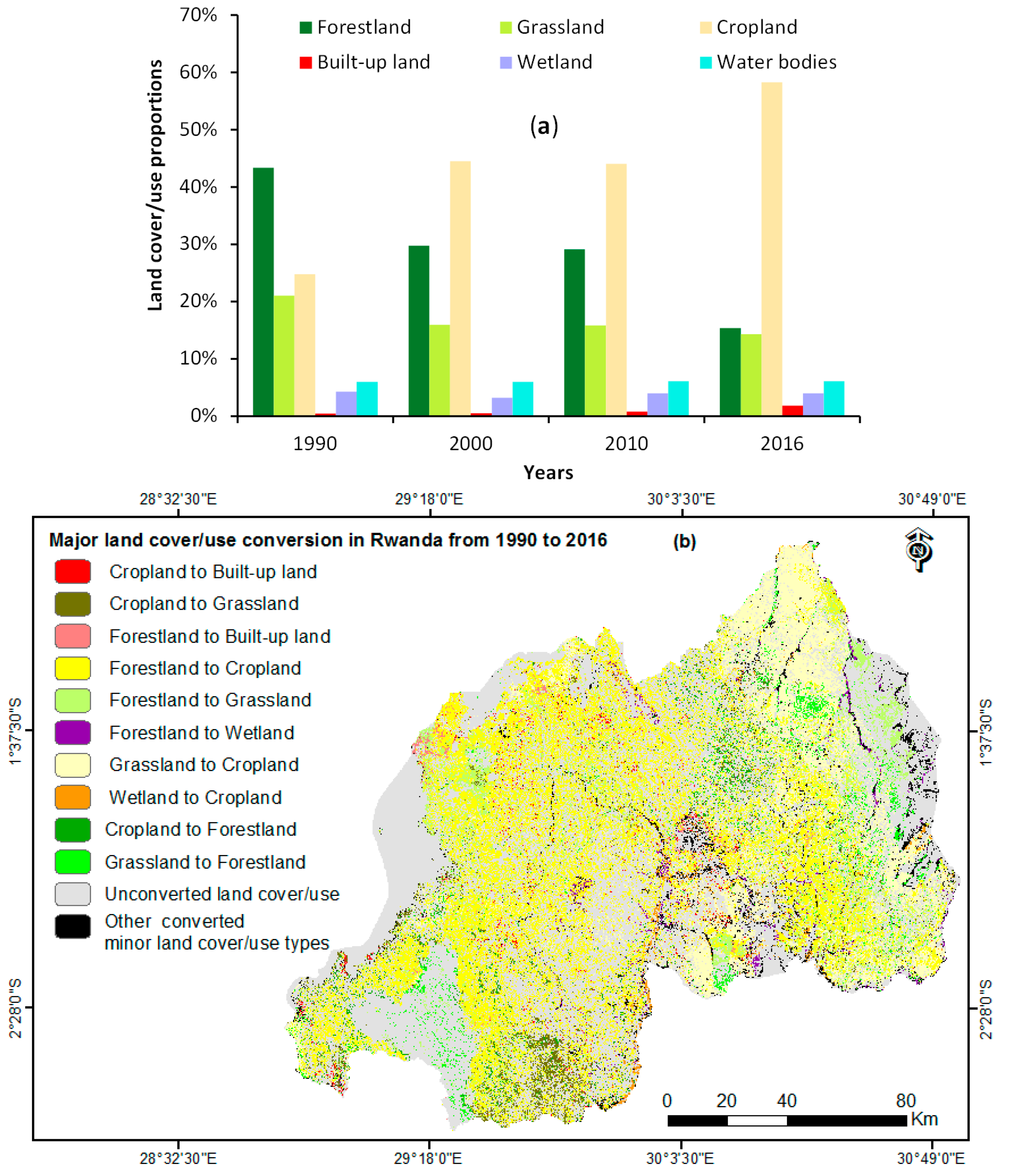
3.1. Land-Use Change from 1990 to 2016

Rwanda experienced a significant conversion of natural forest and grassland in the agricultural land use. During the period 1990–2016, about 7090.02 km2 (64.5%) and 1715.26 km2 (32.1%) of forest and grassland covers were lost, respectively. Whilst during this period, the cropland and built-up land areas increased by 135.3% (8503.75 km2) and 304.3% (355.02 km2), respectively (Figure 8 and Table 4). We found that 348.25 km2 (3.2%) of the forest, 546.86 km2 (10.23%) of the grassland and 33.60 km2 (3.1%) of wetland in 1990 were converted to croplands (Table 5). Intensive land use changes took place in the 1990s and the 2010–2016 periods, particularly after the year 2010, when the deforestation rate was nearly twice of that in the 1990s. In contrast, only minor land use changes took place in the early 2000s because of the war and genocide against Tutsi in 1994. During the period 1990–2000, there were no stable agricultural activities due to conflicts that forced people to desert their homes and flee to the neighboring countries. After achieving certain levels of stability, returnees were settled to their homelands and continued their agricultural activities [51]. It is understandable that these forests and grassland conversions to agriculture were related to the rapidly growing population, increasing from 294.3 people/km2 in 1990 to 470.6 people/km2 in 2015 [5], along with the fact that today around 80% of the Rwandan population depend on subsistence agriculture for their livelihood [12]. The most significant forest conversion to cropland took place in the districts of Nyamagabe, Ngoma, Rutsiro, Karongi, and Gakenke where 415.33 km2, 397.04 km2, 392.70 km2, 380.66 km2 and 366.70 km2, respectively were lost during the 1990–2016 period (Appendix A: Table A1). During this period, the largest grassland loss has been observed in the districts of the Eastern Province that experienced the most significant cropland expansion (4008.46 km2) where 1404.90 km2 or (54.16%) of their forest and 2718.01 km2 (59.74%) of the grassland around the National Akagera park were converted to cropland. The most significant forest loss of 2018.62 km2 (58.84%) took place in the Western Province during the 1990–2016 period (Appendix B: Table A2). During the same period, the national water body coverage increased by 1.40% (21.52 km2) (Table 4) due to permanent flooding of some wetlands. The expanded water extent resulted from large rainwater runoff volumes which swiftly carried to local streams, lakes, wetlands and rivers as a result of cropland and urban expansion that are characterized by low capacity in rainwater infiltration [17].

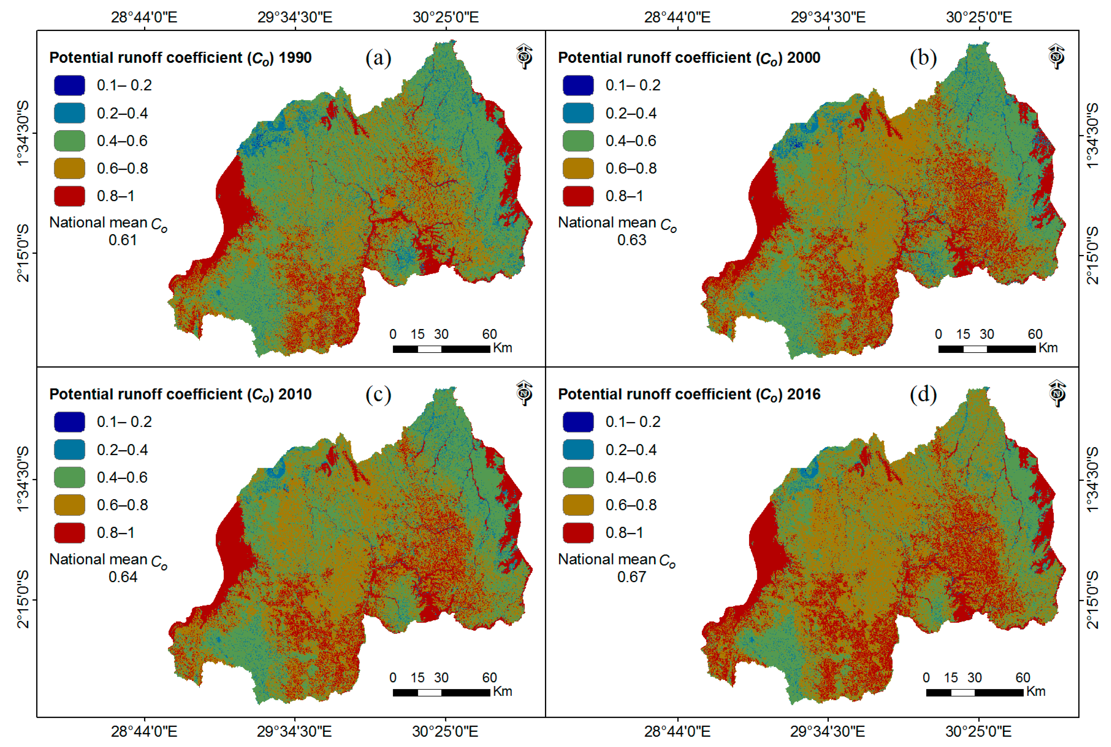
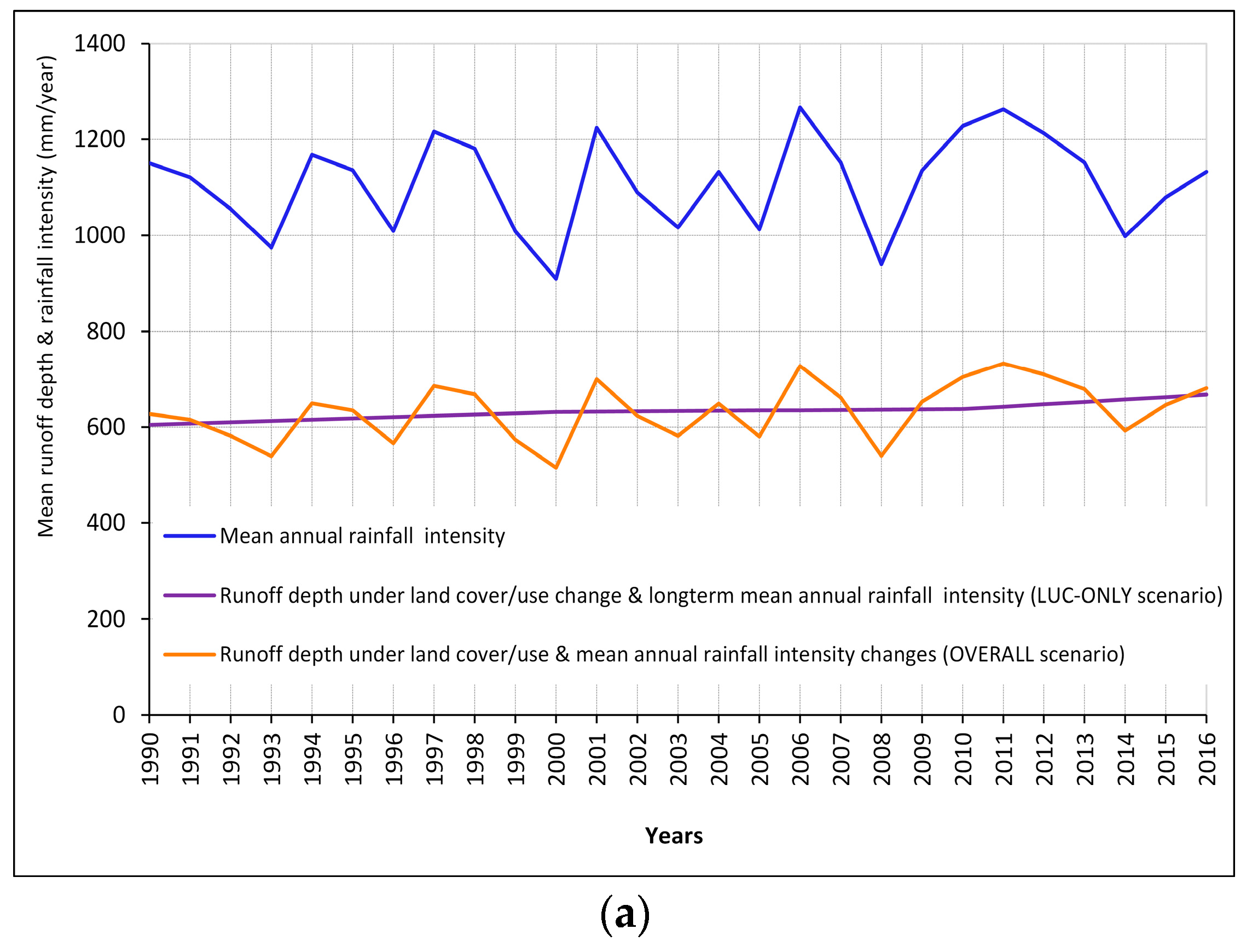
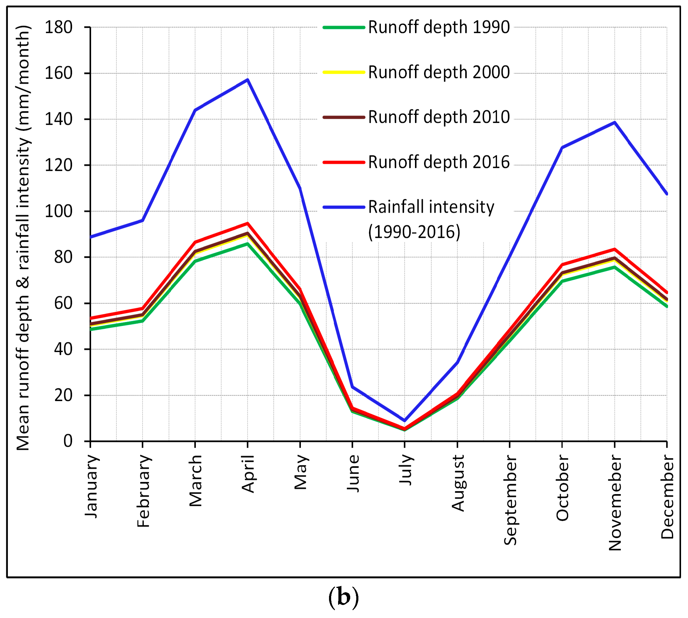
3.2. The Temporal Patterns of Runoff Depth from 1990 to 2016

In response to the precipitation change and the land use change (the OVERALL scenario), the runoff depth in Rwanda has increased from 627 mm/year in 1990 to 681 mm/year in 2016, an 0.31% annual increase (2 mm/year) during the period 1990–2016. The mean annual rainfall intensity was 1151 mm/year and 1133 mm/year in the years 1990 and 2016, respectively. There was a decrease variation in rainfall intensity of 18 mm/year, between the years 1990 and 2016. Under a long-term average rainfall intensity of 1116 mm/year for the period 1990–2016, the land cover/use change effect increased the annual runoff depth by 0.38% (2.33 mm/year), from 605 mm/year in 1990 to 668 mm/year in 2016 (Figure 9a). Our results indicate that the changing trends of annual runoff in Rwanda were dominated by the land use change effect, although the precipitation change was controlled by the annual runoff fluctuation. We found an increase of 9 mm/month in peak runoff depth in April (Figure 9b). The total runoff depth was 520 mm for the 7 months of the wet seasons (March–May and September–December) and 152 mm for the 5 months of the dry seasons (January–February and June–August) in 2016 (Figure 9b). The peak runoff depth in a year (in April) was 17.4 times bigger than that of the minimum runoff depth (in July) in 2016. The total wet season runoff accounted for 77.4% of the annual runoff, and was 3.4 times larger than the dry season runoff. Long-term monthly mean precipitation for the period 1990–2016 ranged from 9 mm/month in July (the driest month) to 157 mm/month in April (the wettest month) (Figure 9b).

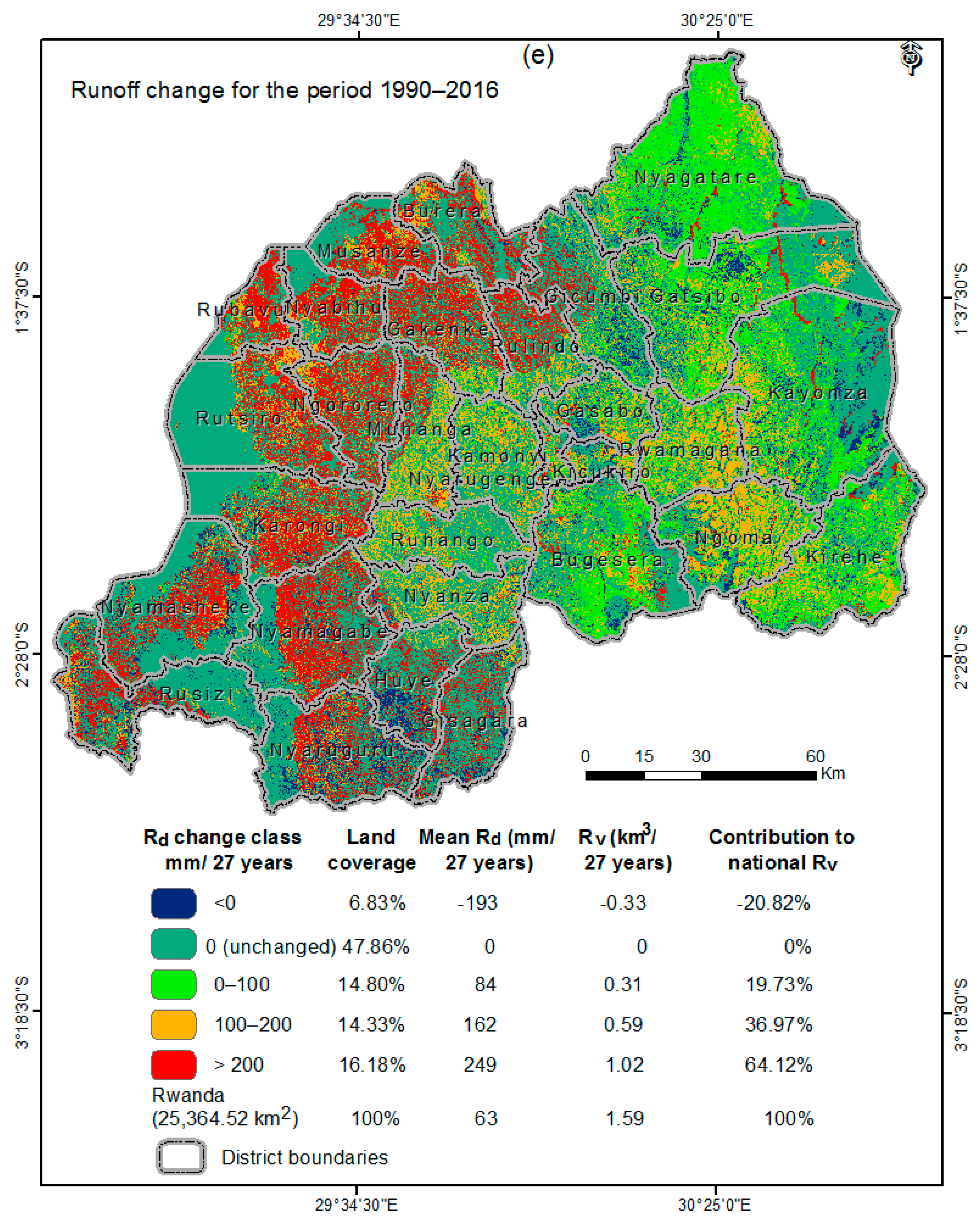
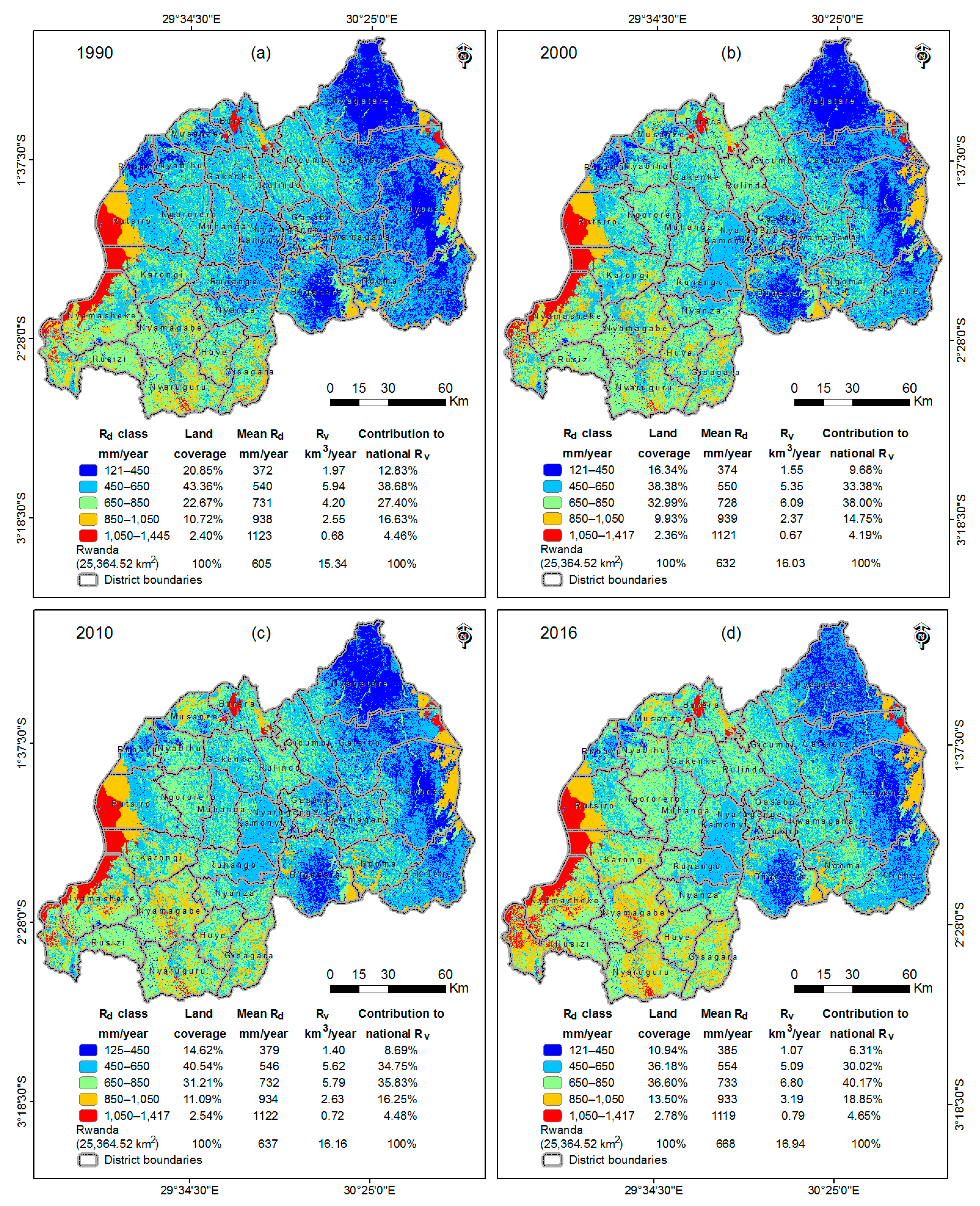
3.3. The Spatial Pattern in Runoff Change during the Period 1990–2015

For the purpose of facilitating the analysis and identifying runoff hotspot areas requiring high priority for conservation practices, the runoff data were classified into five levels in Figure 10. The highest runoff >1050 mm/year was found in the water bodies and land areas with high rainfall intensity (1282 mm/year) and the non-water land area with a mean steep slope of 25%. Relatively low runoff <450 mm/year was found in the area with low precipitation (953 mm/year) and plateau (gentle mean slope of 8%). In these areas, the forest and grassland increased by 29% and 10%, respectively, while, the cropland and built-up land decreased by 11% and 30%, respectively for the period 1990–2016.
It is noteworthy that the 16.18% area of the country that had a high mean precipitation of 1222 mm/year and a steep slope of 28% experienced a significant increase in runoff depth >200 mm from 1990 to 2016 (Figure 10e). These areas experienced the most severe deforestation and grassland conversion to cropland (Figure 8b), where a total of 41,877 km2 (100%) of the forest and 132.64 km2 (100%) of the grassland were lost. For example, these areas underwent significant changes where 3838 km2 (92%) of the forest were converted to cropland; the cropland and urban land were expanded to 3795.53 km2 and 227.46 km2, respectively from 1990 to 2016. There was a total runoff depth decrease of 193 mm (Figure 10e) over 6.83% of the total country’s area, characterized by a mean rainfall intensity of 1108 mm/year and a mean steep slope of 24%. In these areas, there was an afforestation on 869.70 km2 (50.19% of its extent) and the grassland increased by 47% (201.8 km2), while, the cropland and built-up land decreased by 75% (675.20 km2) and 77% (34.85 km2), respectively (Figure 8b).
Among the 30 administrative districts of Rwanda, the top five districts in runoff depth (all >770 mm/year) in 2016 are Nyamasheke, Rusizi, Rutsiro, Karongi, and Nyaruguru due to high mean rainfall intensity ranging between 1194 mm and 1450 mm/year and steep slope ranging between 19% and 30%. The top five districts in runoff increase (all >3.8 mm/year) are Rubavu, Nyabihu, Ngororero, Gakenke, and Musanze. Their annual runoff depths increased at a rate of >3.8 mm/year during the past 27 years (Table 6), due to severe deforestation (ranging from 62% to 85%) and cropland expansion (ranging from 123% to 293%) (Appendix A: Table A1).

4. Discussion

4.1. Land Use and Land Cover Change Impact on Rainfall Runoff in Rwanda

Rwanda experienced a significant conversion of natural forest and grassland into agricultural land use. During the period 1990–2016, about 6183.41 km2 (56.26%) of forest, 3183.24 km2 (59.56%) of grassland and 166.88 km2 (15.23%) of wetland have been converted to croplands (Table 5) and resulted in a runoff depth increase of 2.33 mm/year (0.38%) (Figure 9b). Spatial statistical analysis revealed that 16.18% of the total country’s area—with high mean precipitation (1222 mm/year) and a steep slope of 28%—experienced a significant increase in runoff depth >200 mm from 1990 to 2016 (Figure 10e), due to severe deforestation and grassland conversion to cropland (Figure 8b). In these areas, a total of 418.77 km2 of forest and 132.64 km2 of grassland were lost. Over 6.83% of the country’s area—characterized by a mean rainfall of 1108 mm/year and a mean steep slope of 24%—experienced a total runoff depth decrease of 193 mm (Figure 10e) has been noted during the past 27 years. This decrease may have resulted from the observed afforestation on 869.70 km2 (50.19%) and the approximate 47% increase of grassland (201.8 km2) while the cropland and built-up land decreased by 75% (675.2 km2) and 77% (34.85 km2), respectively as shown in Figure 8b.

4.2. Potential Benefits of Rainfall Runoff Management in Rwanda

Although Rwanda is known as an equatorial country with high rainfall, poor water management and low soil fertility, unreliable and erratic rainfall have continued to threaten the food production in major arid and semi-arid regions [49]. Rainwater runoff management in Rwanda might achieve two important goals: One is the environmental protection in terms of water pollution control, erosion, floods and landslide mitigation. The second goal is an economic goal that would be achieved through harvesting rainwater using dams, reservoirs and tanks for irrigation purposes during summer months, late rainfall onsets or early rainfall cessations. It was previously reported that, among other Climate Change Adaptation Strategies, Rwanda has to put effort into land use and water management [52]. Assumptions about future climate and water use predicted the water scarcity problem in Southern and Eastern African countries, including Rwanda, because of improved living standards and a constantly increasing population [53].
As a recommendation, rainwater harvesting might be one of the adaptation policies to climate change, especially in the Eastern Province and the Eastern parts of Nyanza and Gisagara districts in the Southern Province of Rwanda where high frequency of rainfall deficit, late rainfall onsets, early rainfall cessations, and drought events have become increasingly severe in the recent decades [54,55]. Furthermore, rainwater runoff harvesting could reduce the stress of water scarcity that can be accelerated by water uses for irrigation [56]. Our estimates revealed that 30.5% (3.99 km3) of the wet seasons’ rainwater runoff, once harvested, could bridge the gap in rainwater inflow and irrigation water requirements for the total cropland area during 5 months of the dry season in Rwanda (Table 7).

4.3. Uncertainities

Generally, runoff measurements based on stream gauge stations are the best way to accurately quantify rainfall runoff in the catchment of interest and constitute a valuable source of data for validating runoff results estimated based on hydrological models. The lack of these gauge stations remains a critical challenge for assessing stormwater runoff in Rwanda. However, validation was not conducted due to the lack of data; it should be noted that the WetSpa model was chosen as an alternative method that relies on the freely available geospatial data to help stakeholders to understand the impact of land use and land cover changes on rainwater runoff and guide them in policy making for the mitigation of stormwater runoff-related disasters in Rwanda. The potential runoff coefficients used in this model were calibrated based on the published data from various field runoff measurements [21] and showed reliable results in differents hydrological studies [22].

5. Conclusions

This study indicated that the large-scale deforestation (64.5%) and 32.1% of the grassland over the past 27 years (1990–2016) resulted in a 2.33 mm/year (0.38%) increase in national runoff depth in Rwanda from 1990 to 2016. The long-term trend of runoff change in the country was dominated by land use change, leading to serious environmental disasters such as floods, landslides, and soil erosion. The significant imbalances in monthly runoff distribution indicate that appropriate management and reservation of peak-month runoff would reduce the pressure that is inherent from the deficiency of irrigation water during the drought periods. This study has found that harvesting 30.5% (3.99 km3) of the wet season rainwater runoff could cover the deficiency in rainwater that is necessary to irrigate the entirety of Rwanda’s cropland during the 5 months of the dry season in 2016.

Acknowledgments

The authors would like to thank the editor and anonymous reviewers for their valuable comments and suggestions to improve the quality of this paper. This study is supported by the National Basic Research Programs of China (#2014CB954204) and the National Natural Scientific Foundation of China (#U1503301).

Author Contributions

Fidele Karamage, Chi Zhang, Tong Liu and Felix Ndayisaba processed the data and wrote the manuscript. Xia Fang, Alphonse Kayiranga, Lamek Nahayo, and Jean Baptiste Nsengiyumva helped in statistical analysis and discussion.

Conflicts of Interest

The authors declare no conflicts of interest.

Abbreviations

hahectare
mmmillimeter
KmKilometer
RWFRwandan Franc
Euro

Appendix A

Table A1. Land cover/use types per district in 2016 and their changes (1990–2016).
DistrictLCLU Extent 2016 (km2)LCLU Change 1990–2016 (km2)
NamesCoverage (%)ForestlandGrasslandCroplandBuilt-Up LandWetlandWaterForestlandGrasslandCroplandBuilt-Up LandWetlandWater
Bugesera5.1152.06129.56810.7144.59180.3679.28−151.14−318.36453.1640.33−25.110.95
Burera2.5592.3526.45406.548.1552.7460.05−247.10−20.38255.478.150.054.15
Gakenke2.78119.8876.71485.5519.910.582.50−366.7049.02299.8519.90−2.390.42
Gasabo1.7086.0036.04252.0849.194.172.84−114.21−15.59116.5114.10−0.85−0.01
Gatsibo6.26202.66444.58766.239.34128.5437.60−241.75−328.62558.926.069.14−3.77
Gicumbi3.27258.1760.43495.566.877.092.23−135.21−17.46144.396.871.540.00
Gisagara2.6956.9244.40530.588.4839.791.21−142.1441.14125.078.17−27.86−5.00
Huye2.3023.8989.95452.0410.545.150.44−142.7088.9143.964.705.170.18
Kamonyi2.6123.8944.36556.7610.0424.261.80−217.52−11.68225.448.73−2.67−2.36
Karongi3.90147.3291.10533.4116.740.13201.32−380.6634.62328.3315.86−0.272.21
Kayonza7.64195.67779.25608.9510.02185.02159.55−248.12−290.64554.218.92−20.99−4.20
Kicukiro0.669.147.03100.9132.5116.061.77−53.68−6.1165.731.52−7.740.14
Kirehe4.70131.76300.95592.9011.41115.1239.93−274.95−277.76536.6411.404.38−0.48
Muhanga2.5588.6955.07484.677.427.544.20−322.8728.18284.295.054.221.39
Musanze2.08127.8726.99332.0322.840.0018.37−211.23−16.14205.8120.960.000.70
Ngoma3.4474.11155.28482.107.4089.9962.33−397.045.28399.342.50−14.674.76
Ngororero2.6761.7573.79519.8820.610.151.20−355.9450.47286.8320.61−1.20−0.71
Nyabihu2.12105.5148.32362.6919.210.002.74−254.0619.05213.5718.800.002.90
Nyagatare7.58113.92368.541315.7212.2099.1213.41−167.90−992.981148.058.640.612.94
Nyamagabe4.31333.5976.72667.1314.060.450.18−415.3345.25355.5714.060.460.18
Nyamasheke4.62424.4694.73407.8012.780.08231.81−263.4147.66195.5512.780.087.74
Nyanza2.6534.0213.46597.964.4222.410.77−213.90−4.15215.644.42−2.180.28
Nyarugenge0.5225.287.5765.1019.9814.280.55−40.37−3.4442.934.38−1.73−1.89
Nyaruguru3.99304.14208.08496.963.130.060.07−255.77170.9482.453.13−0.620.04
Rubavu1.5355.7053.89189.0840.490.0047.46−217.1740.06141.0235.850.000.27
Ruhango2.4712.5710.56587.163.7512.600.39−180.68−38.44207.783.757.780.05
Rulindo2.2472.5618.58466.1910.380.240.47−236.38−4.57231.6910.37−0.65−0.42
Rusizi3.79451.2271.48365.1921.650.8950.14−154.68−19.56145.5221.650.916.61
Rutsiro4.58165.42124.88369.992.220.00498.97−392.70106.95281.932.220.001.42
Rwamagana2.6948.0193.45485.6511.4515.3728.73−294.71−76.91358.1011.14−0.423.02
Rwanda1003898.533632.2014,787.52471.781022.191552.31−7090.02−1715.268503.75355.02−75.0121.51

Appendix B

Table A2. Major land cover/use types per province in 2016, their changes and conversions (1990–2016).
ProvinceLCLU 2016 (Km2)LCLU Change 1990–2016 (Km2)LCLU Conversion 1990–2016 (Km2)
NamesCoverage (%)ForestlandGrasslandCroplandForestlandGrasslandCroplandForest. to Crop.Grass. to Crop.
Kigali2.88120.4950.5994.93−208.27−25.14225.17183.1255.40
North12.92671.15208.99496.32−1196.63−9.531137.191108.07155.26
South23.57878.14542.14992.99−1890.91320.171540.181791.06122.97
East37.42818.582269.621149.44−1775.59−2280.014008.461404.902718.01
West23.211412.07557.71623.98−2018.62279.251592.751696.25131.60
Rwanda1003900.433629.053357.66−7090.02−1715.268503.756183.413183.24

References

  1. Goudie, A. The Human Impact on the Natural Environment; MIT Press: Cambridge, MA, USA, 2000. [Google Scholar]
  2. Tilman, D.; Fargione, J.; Wolff, B.; D’Antonio, C.; Dobson, A.; Howarth, R.; Schindler, D.; Schlesinger, W.H.; Simberloff, D.; Swackhamer, D. Forecasting agriculturally driven global environmental change. Science 2001, 292, 281–284. [Google Scholar] [CrossRef] [PubMed]
  3. Karamage, F.; Shao, H.; Chen, X.; Ndayisaba, F.; Nahayo, L.; Kayiranga, A.; Omifolaji, J.K.; Liu, T.; Zhang, C. Deforestation effects on soil erosion in the lake kivu basin, dr congo-rwanda. Forests 2016, 7, 281. [Google Scholar] [CrossRef]
  4. Weng, Q. Modeling urban growth effects on surface runoff with the integration of remote sensing and gis. Environ. Manag. 2001, 28, 737–748. [Google Scholar] [CrossRef]
  5. UN. World Population Prospects: The 2015 Revision. Population Division, Desa. Available online: http://esa.un.org/unpd/wpp/ (accessed on 25 October 2016).
  6. Karamage, F.; Zhang, C.; Ndayisaba, F.; Shao, H.; Kayiranga, A.; Fang, X.; Nahayo, L.; Muhire Nyesheja, E.; Tian, G. Extent of cropland and related soil erosion risk in Rwanda. Sustainability 2016, 8, 609. [Google Scholar] [CrossRef]
  7. Habiyaremye, G.; Jiwen, G.; de la Paix Mupenzi, J.; Balogun, W.O. Demographic pressure impacts on forests in Rwanda. Afr. J. Agric. Res. 2011, 6, 4533–4538. [Google Scholar]
  8. Grinning Planet. Water Pollution Solutions. Available online: http://www.grinningplanet.com/2008/01-08/water-pollution-solutions-article.htm (accessed on 20 August 2016).
  9. Nezlin, N.P.; Digiacomo, P.M.; Stein, E.D.; Ackerman, D. Stormwater runoff plumes observed by seawifs radiometer in the southern California bight. Remote Sens. Environ. 2005, 98, 494–510. [Google Scholar] [CrossRef]
  10. Korkmaz, N.; Avci, M. Evaluation of water delivery and irrigation performances at field level: The case of the menemen left bank irrigation district in Turkey. Indian J. Sci. Technol. 2012, 5, 2079–2089. [Google Scholar]
  11. Anaba, L.A.; Banadda, N.; Kiggundu, N.; Wanyama, J.; Engel, B.; Moriasi, D. Application of SWAT to assess the effects of land use change in the Murchison Bay Catchment in Uganda. Comput. Water Energy Environ. Eng. 2017, 6, 24–40. [Google Scholar] [CrossRef]
  12. Munyaneza, O.; Majoro, F.; Hagenimana, E.; Usabyisa, W. Impact assessment of hillside rainwater harvesting ponds on agriculture income: Case study of ntarama sector in Rwanda. J. Water Resour. Prot. 2016, 8, 844. [Google Scholar] [CrossRef]
  13. Lacasse, S.; Nadim, F. Landslide risk assessment and mitigation strategy. In Landslides–Disaster Risk Reduction; Springer: Berlin/Heidelberg, Germany, 2009; pp. 31–61. [Google Scholar]
  14. Meyer, W.B.; Turner, B. Changes in Land Use and Land Cover: A Global Perspective; Cambridge University Press: Cambridge, UK, 1994. [Google Scholar]
  15. Karamage, F.; Zhang, C.; Kayiranga, A.; Shao, H.; Fang, X.; Ndayisaba, F.; Nahayo, L.; Mupenzi, C.; Tian, G. Usle-based assessment of soil erosion by water in the Nyabarongo River Catchment, Rwanda. Int. J. Environ. Res. Public Health 2016, 13, 835. [Google Scholar] [CrossRef] [PubMed]
  16. Nhapi, I.; Wali, U.; Uwonkunda, B.; Nsengimana, H.; Banadda, N.; Kimwaga, R. Assessment of water pollution levels in the Nyabugogo Catchment, Rwanda. Open Environ. Eng. J. 2011, 4, 40–53. [Google Scholar] [CrossRef]
  17. REMA. The Assessment of Economic Impacts of the 2012 Wet Season Flooding in Rwanda. Available online: http://www.rema.gov.rw/fileadmin/templates/Documents/rema_doc/Planing_Dpt/FINAL%20REPORT%20ECONOMIC%20IMPACT%20OF%202012%20WET%20SEASON.pdf (accessed on 20 November 2016).
  18. MIDIMAR. The National Risk Atlas of Rwanda. Available online: http://midimar.gov.rw/uploads/tx_download/National_Risk_Atlas_of_Rwanda.pdf (accessed on 15 August 2016).
  19. De la Paix, M.J.; Lanhai, L.; Jiwen, G.; de Dieu, H.J.; Gabriel, H.; Jean, N.; Innocent, B. Radical terraces in Rwanda. East Afr. J. Sci. Technol. 2012, 1, 53–58. [Google Scholar]
  20. Munyaneza, O. Space-Time Variation of Hydrological Processes and Water Resources in Rwanda: Focus on the Migina Catchment. Ph.D. Thesis, UNESCO-IHE, Institute for Water Education, Delft, The Netherlands, 7 May 2014. [Google Scholar]
  21. Liu, Y.; De Smedt, F. Wetspa Extension, a Gis-Based Hydrologic Model for Flood Prediction and Watershed Management; Documentation and User Manual; Vrije Universiteit Brussel: Brussel, Belgium, 2004. [Google Scholar]
  22. Mahmoud, S.H. Investigation of rainfall–runoff modeling for Egypt by using remote sensing and gis integration. Catena 2014, 120, 111–121. [Google Scholar] [CrossRef]
  23. Nagarajan, N.; Poongothai, S. Spatial mapping of runoff from a watershed using scs-cn method with remote sensing and gis. J. Hydrol. Eng. 2011, 17, 1268–1277. [Google Scholar] [CrossRef]
  24. Hong, Y.; Adler, R.F.; Hossain, F.; Curtis, S.; Huffman, G.J. A first approach to global runoff simulation using satellite rainfall estimation. Water Resour. Res. 2007, 43. [Google Scholar] [CrossRef]
  25. Artan, G.; Gadain, H.; Smith, J.L.; Asante, K.; Bandaragoda, C.J.; Verdin, J.P. Adequacy of satellite derived rainfall data for stream flow modeling. Nat. Hazards 2007, 43, 167–185. [Google Scholar] [CrossRef]
  26. Rwanda Natural Resources Authority (RNRA). National Land Use Planning Portal. Administrative Boundaries. Available online: https://rwandalanduse.rnra.rw/index.php?id=38 (accessed on 15 August 2015).
  27. Twagiramungu, F. Environmental Profile of Rwanda; Consultancy Report; European Commission: Kigali, Rwanda, 2006; p. 78. [Google Scholar]
  28. Ntwali, D.; Ogwang, B.A.; Ongoma, V. The impacts of topography on spatial and temporal rainfall distribution over Rwanda based on WRF model. Atmos. Clim. Sci. 2016, 6, 145. [Google Scholar] [CrossRef]
  29. United Nations (UN). World Urbanization Prospects: The 2014 Revision, CD-ROM Edition. Available online: http://esa.un.org/unpd/wpp/ (accessed on 4 September 2016).
  30. Van Engelen, V.; Verdoodt, A.; Dijkshoorn, K.; Van Ranst, E. Soil and Terrain Database of Central Africa-DR of Congo, Burundi and Rwanda (Sotercaf, Version 1.0); ISRIC-UGent-FAO: Wageningen, The Netherlands, 2006; Available online: http://www.isric.org/isric/webdocs/docs/ISRIC_Report_2006_07.pdf (accessed on 28 July 2016).
  31. Schueler, T.R. Controlling Urban Runoff: A Practical Manual for Planning and Designing Urban BMPs; Metropolitan Washington Council of Governments: Washington, DC, USA, 1987. [Google Scholar]
  32. Mitchell, G.; Lockyer, J.; McDonald, A. Pollution Hazard from Urban Nonpoint Sources: A Gis-Model to Support Strategic Environmental Planning in the UK; University of Leeds: Leeds, UK, 2001; Available online: http://www.geog.leeds.ac.uk/projects/nps/reports.htm (accessed on 25 June 2016).
  33. Funk, C.; Peterson, P.; Landsfeld, M.; Pedreros, D.; Verdin, J.; Shukla, S.; Husak, G.; Rowland, J.; Harrison, L.; Hoell, A.; et al. The climate hazards infrared precipitation with stations—A new environmental record for monitoring extremes. Sci. Data 2015, 8, 150066. [Google Scholar] [CrossRef] [PubMed]
  34. RCMRD. Land Cover Viewer: Eastern & Southern Africa. Available online: http://apps.rcmrd.org/landcoverviewer/ (accessed on 20 October 2016).
  35. United States Geological Survey (USGS). USGS Global Visualization Viewer: Earth Resources Observation and Science ceNter (EROS). Available online: http://glovis.usgs.gov/index.shtml (accessed on 20 September 2016).
  36. Otukei, J.R.; Blaschke, T. Land cover change assessment using decision trees, support vector machines and maximum likelihood classification algorithms. Int. J. Appl. Earth Obs. Geoinf. 2010, 12, S27–S31. [Google Scholar] [CrossRef]
  37. Basnet, B.; Vodacek, A. Tracking land use/land cover dynamics in cloud prone areas using moderate resolution satellite data: A case study in Central Africa. Remote Sens. 2015, 7, 6683–6709. [Google Scholar] [CrossRef]
  38. Anderson, J.R. A Land Use and Land Cover Classification System for Use with Remote Sensor Data; U.S. Government Printing Office: Washington, DC, USA, 1976; Volume 964.
  39. Long, J.B.; Giri, C. Mapping the Philippines’ mangrove forests using landsat imagery. Sensors 2011, 11, 2972–2981. [Google Scholar] [CrossRef] [PubMed]
  40. Bishop, Y.M.; Fienberg, S.E.; Holland, P.W. Discrete Multivariate Analysis: Theory and Practice; Massachusetts Institute of Technology Press: Cambridge, MA, USA, 1975. [Google Scholar]
  41. Mather, P.; Koch, M. Computer Processing of Remotely-Sensed Images: An Introduction; John Wiley & Sons: Hoboken, NJ, USA, 2011. [Google Scholar]
  42. Thomlinson, J.R.; Bolstad, P.V.; Cohen, W.B. Coordinating methodologies for scaling landcover classifications from site-specific to global: Steps toward validating global map products. Remote Sens. Environ. 1999, 70, 16–28. [Google Scholar] [CrossRef]
  43. Manandhar, R.; Odeh, I.O.; Ancev, T. Improving the accuracy of land use and land cover classification of landsat data using post-classification enhancement. Remote Sens. 2009, 1, 330–344. [Google Scholar] [CrossRef]
  44. Huang, C.; Goward, S.N.; Masek, J.G.; Thomas, N.; Zhu, Z.; Vogelmann, J.E. An automated approach for reconstructing recent forest disturbance history using dense landsat time series stacks. Remote Sens. Environ. 2010, 114, 183–198. [Google Scholar] [CrossRef]
  45. Adam, A.H.M.; Elhag, A.; Salih, A. Accuracy assessment of land use & land cover classification (lu/lc), case study of Shomadi Area, Renk County, Upper Nile State, South Sudan. Int. J. Sci. Res. Publ. 2013, 3, 1–6. [Google Scholar]
  46. Hengl, T.; Heuvelink, G.B.; Kempen, B.; Leenaars, J.G.; Walsh, M.G.; Shepherd, K.D.; Sila, A.; MacMillan, R.A.; de Jesus, J.M.; Tamene, L. Mapping soil properties of africa at 250 m resolution: Random forests significantly improve current predictions. PLoS ONE 2015, 10, e0125814. [Google Scholar] [CrossRef] [PubMed]
  47. Fernandez-Illescas, C.P.; Porporato, A.; Laio, F.; Rodriguez-Iturbe, I. The ecohydrological role of soil texture in a water-limited ecosystem. Water Resour. Res. 2001, 37, 2863–2872. [Google Scholar] [CrossRef]
  48. United States Geological Survey (USGS). U.S. Geological Survey Earthexplorer (ee) Tool. Available online: http://earthexplorer.usgs.gov/ (accessed on 20 September 2015).
  49. Munyaneza, O.; Nzeyimana, Y.K.; Wali, U.G. Hydraulic structures design for flood control in the Nyabugogo Wetland, Rwanda. Nile Basin Water Sci. Eng. J. 2013, 6, 2. [Google Scholar]
  50. Frenken, K.; Faurès, J.-M. Irrigation Potential in Africa: A Basin Approach; FAO Land and Water Bulletin, Vol. 4; Food & Agriculture Organization: Rome, Itay, 1997. [Google Scholar]
  51. Uwimbabazi, P.; Lawrence, R. Compelling factors of urbanization and rural-urban migration in Rwanda. Rwanda J. 2011, 22, 9–26. [Google Scholar]
  52. Krysanova, V.; Dickens, C.; Timmerman, J.; Varela-Ortega, C.; Schlüter, M.; Roest, K.; Huntjens, P.; Jaspers, F.; Buiteveld, H.; Moreno, E. Cross-comparison of climate change adaptation strategies across large river basins in Europe, Africa and Asia. Water Resour. Manag. 2010, 24, 4121–4160. [Google Scholar] [CrossRef] [Green Version]
  53. Meigh, J.; McKenzie, A.; Sene, K. A grid-based approach to water scarcity estimates for Eastern and Southern Africa. Water Resour. Manag. 1999, 13, 85–115. [Google Scholar] [CrossRef]
  54. Tschirley, D.; Nijhoff, J.J.; Arlindo, P.; Mwinga, B.; Weber, M.T.; Jayne, T.S. Anticipating and Responding to Drought Emergencies in Southern Africa: Lessons from the 2002–2003 Experience. In Proceedings of the NEPAD Regional Conference on Successes in African Agriculture, Nairobi, Kenya, 22–25 November 2004; pp. 22–25.
  55. Nabahungu, N.; Visser, S. Farmers’ knowledge and perception of agricultural wetland management in Rwanda. Land Degrad. Dev. 2013, 24, 363–374. [Google Scholar] [CrossRef]
  56. Karamage, F.; Zhang, C.; Ndayisaba, F.; Nahayo, L.; Kayiranga, A.; Omifolaji, J.K.; Shao, H.; Umuhoza, A.; Nsengiyumva, J.B.; Liu, T. The need for awareness of drinking water loss reduction for sustainable water resource management in Rwanda. J. Geosci. Environ. Prot. 2016, 4, 74. [Google Scholar] [CrossRef]
Figure 1. Map of elevation, lakes, rivers, streams and district administrative boundaries for Rwanda.
Water 09 00147 g001
Figure 2. A flowchart used for modeling rainwater runoff in Rwanda.
Water 09 00147 g002
Figure 3. Maps of the potential runoff coefficients of Rwanda for the periods: (a) 1990; (b) 2000; (c) 2010; and (d) 2016.
Water 09 00147 g003
Figure 4. Long-term average annual rainfall intensity in Rwanda (1990–2016).
Water 09 00147 g004
Figure 5. Land cover and land use maps of Rwanda for the periods: (a) 1990; (b) 2000; (c) 2010; and (d) 2016.
Water 09 00147 g005
Figure 6. Percent content of: (a) clay; (b) silt; (c) sand and (d) soil textural classes for Rwanda.
Water 09 00147 g006
Figure 7. Slope map of Rwanda.
Water 09 00147 g007
Figure 8. (a) Land cover/use dynamics, and (b) major land cover/use conversions in Rwanda (1990–2016).
Water 09 00147 g008
Figure 9. (a) Annual runoff depth in response to land use change (LUC-ONLY) and the combined effects of land use and climate changes (OVERALL) in Rwanda; and (b) The average monthly runoff depth under the LUC-ONLY scenario.
Water 09 00147 g009aWater 09 00147 g009b
Figure 10. Spatial patterns of runoff depth (Rd) and runoff volumes (Rv) in (a) 1990; (b) 2000; (c) 2010; (d) 2016; and (e) the runoff changes from 1990 to 2016 in Rwanda, as estimated by the LUC-ONLY scenario.
Water 09 00147 g010aWater 09 00147 g010b
Table 1. The potential runoff coefficient for different land use, soil type and slope.
Land UseSlope (%)LoamSandy Clay LoamClay LoamSandy ClayClay
Forestland<0.50.130.230.270.330.40
0.5–50.170.270.310.370.44
5–100.230.330.370.430.50
>100.350.450.490.550.62
Grassland<0.50.230.330.370.430.50
0.5–50.270.370.410.470.54
5–100.330.430.470.530.60
>100.450.550.590.650.72
Cropland<0.50.330.430.470.530.60
0.5–50.370.470.510.570.64
5–100.430.530.570.630.70
>100.550.650.690.750.82
Built-up land<0.50.620.670.690.720.75
0.5–50.640.690.710.740.77
5–100.670.720.740.770.80
>100.730.780.800.830.86
Wetland<0.51.001.001.001.001.00
0.5–51.001.001.001.001.00
5–101.001.001.001.001.00
>101.001.001.001.001.00
Water body<0.51.001.001.001.001.00
0.5–51.001.001.001.001.00
5–101.001.001.001.001.00
>101.001.001.001.001.00
Table 2. Error Matrix for land cover and land use map (Figure 5d) of Rwanda 2016.
Land Use Category(1)(2)(3)(4)(6)(7)User AccuracyCommission Error
(1) Forestland49630105983.1%16.9%
(2) Grassland85250306876.5%23.5%
(3) Cropland32499206575.4%24.6%
(4) Built-up land00151005298.1%1.9%
(5) Wetland00205205496.3%3.7%
(6) Water bodies00002606296.8%3.2%
606060606060360
Producer accuracy81.7%86.7%81.7%85.0%86.7%100%
Omission error18.3%13.3%18.3%15.0%13.3%0.0%
Overall accuracy86.9%
Kappa coefficient84.3%
Table 3. Soil textural classification using the percent of sand, silt and clay content (adapted from the United States Department of Agriculture (USDA) soil texture triangle [47]).
Soil Texture NameSandSiltClay
Sandy soil85–1000–150–10
Loamy sand70–900–300–15
Sandy loam43–800–500–20
Loam23–5228–507–27
Silt loam0–5050–880–27
Silt0–2088–1000–12
Sandy clay loam45–800–2820–35
Clay loam20–4515–5327–40
Silty clay loam0–2040–7327–40
Sandy clay45–650–2035–45
Silty clay0–2040–6040–60
Clay0–450–4040–100
Table 4. Land cover/use changes (Km2) in Rwanda (1990–2016).
PeriodForestlandGrasslandCroplandBuilt-Up LandWetlandWater
1990–2000−3444.50−1288.524996.8122.83−286.620.00
2000–2010−154.72−40.58−109.0771.02215.6017.76
2010–2016−3490.79−386.163616.01261.17−3.983.76
1990–2016−7090.02−1715.268503.75355.02−75.0121.51
Annual change−262.59−63.53314.9513.15−2.780.80
Table 5. Land cover/use conversions (Km2) in Rwanda (1990–2016).
Land UseForestlandGrasslandCroplandBuilt-Up LandWetlandWaterTotal
Forestland-1427.886183.41178.73138.2932.157960.46
Grassland432.06-3183.2468.4476.7016.473776.91
Cropland348.25546.86-142.9133.6010.931082.55
Built-up land4.443.6136.84-0.330.0145.23
Wetland77.3276.82166.886.69-34.65362.36
Water bodies8.356.4815.953.4738.44-72.69
Total870.422061.659586.32400.24287.3694.2113,300.20
Table 6. Analysis of annual runoff depth and runoff volumes at district level.
DistrictMean SlopeMean RainfallMean Runoff Depth (Rd)Runoff Volume (Rv)
NamesExtent (Km2)Angle (%)mm/Yearmm/Year 2016Total Increase mm/27 YearsAnnual Increase mm/YearAnnual Increase %/YearTotal Rv (km3/Year) 2016Contribution to National Rv (%) 2016
Bugesera1296.139926585351.30.240.764.48
Burera646.80261175731883.20.500.472.79
Gakenke705.133611456581023.80.680.462.74
Gasabo431.20231007617532.00.350.271.57
Gatsibo1587.8216983584451.70.310.935.47
Gicumbi829.42341090618371.40.230.513.03
Gisagara682.31211145768190.70.090.523.09
Huye583.38231154744381.40.200.432.56
Kamonyi662.01211004599592.20.410.402.34
Karongi989.22271194793823.00.430.784.63
Kayonza1937.8514946549301.10.211.066.28
Kicukiro167.4112970639411.50.260.110.63
Kirehe1192.1316956572632.30.460.684.02
Muhanga646.80321100643983.60.660.422.45
Musanze527.581913547091033.80.630.372.21
Ngoma872.5415997671792.90.500.593.46
Ngororero677.233612007091084.00.670.482.84
Nyabihu537.733213076961134.20.720.372.21
Nyagatare1922.6313921501582.10.490.965.69
Nyamagabe1093.21321336765863.20.470.844.94
Nyamasheke1171.84261376856542.00.251.005.92
Nyanza672.16201057670612.20.370.452.66
Nyarugenge131.90221006623431.60.270.080.49
Nyaruguru1012.04301376771411.50.210.784.60
Rubavu388.081711996661284.70.880.261.53
Ruhango626.50201027613642.40.430.382.27
Rulindo568.17341116656863.20.560.372.20
Rusizi961.32291450824491.80.230.794.68
Rutsiro1161.70191177824642.40.310.965.65
Rwamagana682.3115957642863.20.570.442.59
Rwanda25,364.52221116668632.30.3816.94100
Table 7. Analysis of wet season runoff reservation for cropland irrigation during the dry season in Rwanda.
CalculationsDescriptionExtentTUV = T × U × 10−8
Area (ha)Depth or Intensity (mm)Volume (km3/T)
AAvailable wet season rainwater/7 monthsTotal Rwanda2,536,45286521.94
BAvailable dry season rainwater/5 monthsTotal Rwanda2,536,4522516.37
C = A + BAvailable rainwater/year (all seasons)Total Rwanda2,536,452111628.31
DAvailable wet season runoff/7 monthsTotal Rwanda2,536,45251613.09
FAvailable dry season runoff/5 monthsTotal Rwanda2,536,4521523.86
G = D + FAvailable runoff/1 year (all seasons)Total Rwanda2,536,45266816.94
HIrrigation water requirement/7 months (wet season)Cropland 20161,478,75272910.78
IIrrigation water requirement/5 months (dry season)Cropland 20161,478,7525217.70
J = H + IIrrigation water requirement/1 yearCropland 20161,478,752125018.48
KAvailable wet season rainwater/7 monthsCropland 20161,478,75286512.79
LAvailable dry season rainwater/5 monthsCropland 20161,478,7522513.71
M = K + ITotal available rainwater/1 year (all seasons)Cropland 20161,478,752111616.50
N = K − HSurplus in rainwater based on irrigation/7 months (wet season)Cropland 20161,478,7521362.01
O = I − LDeficit in rainwater based on irrigation/5 months (dry season)Cropland 20161,478,7522703.99
P = J − MDeficit in rainwater based on irrigation/1 yearCropland 20161,478,7521341.98
R = D − OExtra wet season runoff after meeting the gap in rainfall based on irrigation of the cropland during dry seasonTotal Rwanda2,536,4522466.24
S = F + RExtra runoff after meeting the gap in rainfall based on irrigation of the cropland/1 yearTotal Rwanda2,536,45239810.10

