Article

Ancient to Recent-Past Runoff Harvesting Agriculture in Recharge Playas of the Hyper-Arid Southern Israel

1
Dead Sea and Arava Science Center, Yotvata 88820, Israel
2
Department of Geography, Bar Ilan University, Ramat Gan 52900, Israel
*
Author to whom correspondence should be addressed.
Water 2017, 9(12), 991; https://doi.org/10.3390/w9120991
Submission received: 28 September 2017 / Revised: 7 December 2017 / Accepted: 13 December 2017 / Published: 18 December 2017

Abstract

:
Recharge playas are prevalent throughout the hyper-arid southern Negev and Arava Valley of Israel. While some of these playas are terminal, others were found to be not absolutely terminal, allowing, under extreme floods, the outlet of water from their beds to a draining, ephemeral channel. Indicators for ancient to recent-past agricultural practicing were recorded for two playas. In one of them, this included the archaeological remains of seven Byzantine-Age stone terraces across the playa bed, indicating ancient runoff harvesting agriculture. In another playa, the agricultural indicator included observations by key informants who reported the cropping of barley and wheat by Bedouin populations until the mid-1990s. This was supported by rare bibliographic sources, reporting the cropping of cereals at this site by Bedouins during the 1930s and 1940s. Agro-hydrological assessments of seven playas and their catchments were conducted, revealing a marginal agronomic potential under the current climatic conditions and only for a small number of them. The results highlight the profound environmental know-how of local populations that inhabited this harsh region. Furthermore, the results coincide with previous studies, which have reported drier climatic conditions at present compared to those in ancient times, and even compared to those during the mid-1990s.

1. Introduction

Playas, also named pans, are defined as closed, shallow, terrestrial depressions, characterized by flat and smooth surfaces [1]. Aridity is a determinant factor for their development and dynamics over time [2]. This type of landform occurs where stream channels drain into endorheic (internal) basins, where the water accumulates. Beds of these depressions are dominated by clastic materials, which are deposited from suspension during inundation. The playas, occupying ~1% of the globe’s terrestrial area [3], vary in size from very small depressions of a few tens of square meters, to massive tectonic basins, which may exceed 10,000 km2. For inland playas, catchment lithology and weathering processes are the main determinants of salts precipitated in their beds. Unlike coastal depressions, in inland depressions, airborne dust deposition only encompasses a secondary source of salts [3,4].
Both the water input and water on the playa’s floor are ephemeral in nature [5,6], resulting in a negative balance between input (through direct rainfall and runoff accumulation) and output (evaporation and deep seepage) of water [3,4]. The extent, frequency and length of inundation are dependent on climatic, hydrologic, geologic and pedogenic conditions [6]. Depending on the position of the piezometric level, a playa can recharge the underlying aquifer or can be a discharge area for ground water [7]. In the event of the aquifer’s shallow depth, discharge playas may be formed, where the underground water’s capillary rise results in the salt accumulation at the ground surface. Such playas, also known as salt pans, salars (in South America) or sabkhas (in the Middle East), are frequently covered with salt crusts and displacive evaporites [4,8] and are usually devoid of vegetation [3]. Where deep aquifers occur, with little interaction between the surface and groundwater, recharge playas, also known as pans, clay pans or flat pans, may be formed, with non-saline, clayey and possibly vegetated surfaces [1,3,7]. A range of ecological goods and services can be provided by the playas, including flood prevention and sediment retention [7], as well as salt harvest for human use [3] and water extraction for irrigation [7].
Despite the extensive research on recharge playas around the world, no direct information is available on the topic of ancient, past, or recent-past runoff agriculture (or runoff harvesting agriculture) in such landscape formations, and particularly in hyper-arid regions. A rare example for agricultural land use is the Early Neolithic (~10,000 years BC) site in the Nabta Playa in southern Egypt, where farming activities were dominated by livestock husbandry for the production of milk, blood, and meat [9,10]. In addition, paleobotanic remains of edible plants such as wild millets, sorghum, legumes, tubers and fruits were found at this site, indicating their local consumption during this ancient age [10], but the question of on-site versus off-site growing of these crops still remains open. At the same time, despite not being very common, contemporary farming practices take place in playas. For example, modern agricultural land use was reported for at least five different playas in the semi-arid areas of southern Spain [7].
In the Israeli hyper-arid southern Negev and Arava Valley, several recharge playas and two discharge playas exist (at present, and with a third discharge playa in the upper Gulf of Aqaba, which has been destroyed following urban development of the city of Eilat since the 1960s). Sporadic observations in some of the recharge playas suggested the potential for considerable vegetative productivity. This has been indicated by observing substantial germination and growth of herbaceous vegetation after inundation in the beds of some playas. Furthermore, this accords with testimonies by local inhabitants, revealing the agricultural land use of one of the recharge playas by Bedouin populations up to the mid-1990s, for barley (Hordeum vulgare L.) and wheat (Triticum aestivum L.) production. This also consists with archaeological remains of stone terraces in another recharge playa, indicating runoff harvesting agricultural practice during ancient times.
This study was based on the assumption that in ancient times to the recent-past, local inhabitants practiced agricultural/farming activities wherever possible in this harsh environment. Therefore, the main objective of the study was to assess the concept of runoff agricultural practice in the recharge playas, by studying their hydrological conditions. A secondary objective was to assess the potential for runoff agricultural practices in the recharge playas under current climatic conditions. The study’s major hypothesis was that the physical settings for some of the recharge playas have enabled the practicing of runoff agriculture between ancient times and the recent-past. Yet, the secondary hypothesis was that due to very recent regional aridification, which has particularly imposed decreased rates of rainfall and floods during the last few decades, no agronomic potential exists for these playas at present.

2. Materials and Methods

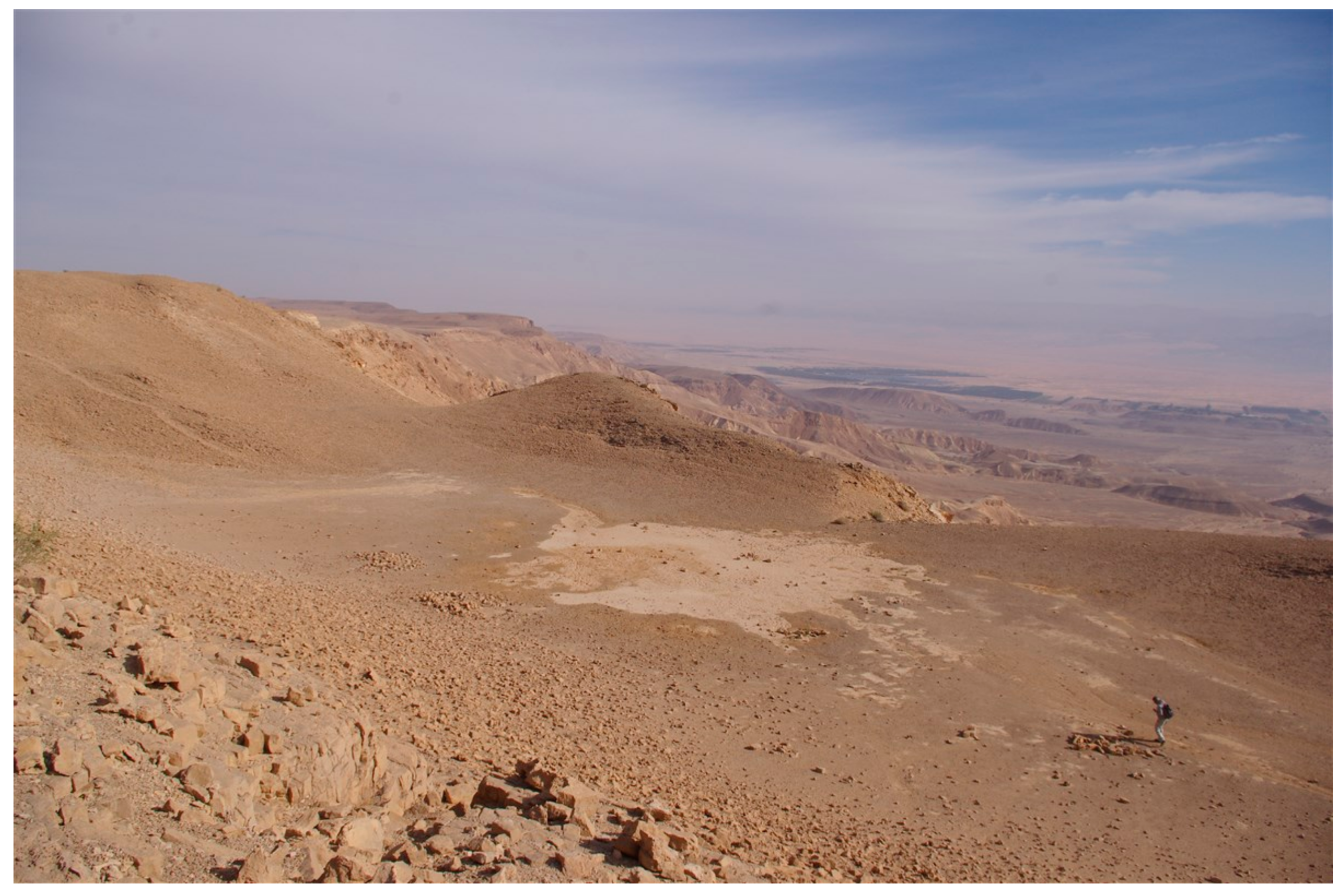
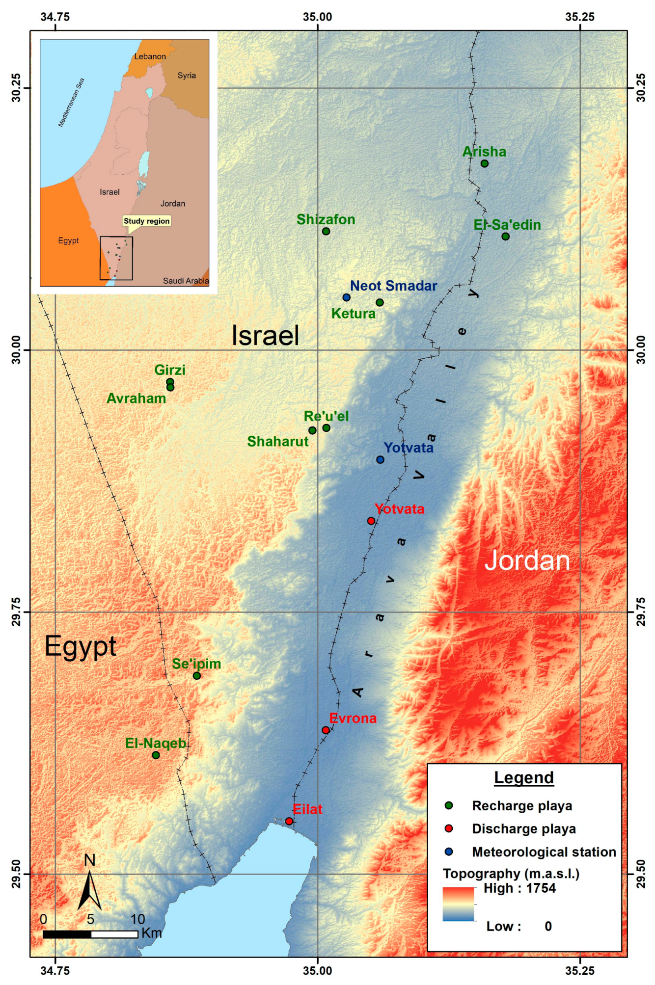
2.1. Regional Settings

The Israeli hyper-arid southern Negev and southern Arava Valley covers ~3000 km2. Lithology is highly varied, dominated by a range of sedimentary rocks, such as chalk, limestone, chert, marl and shale, alongside granite and magmatic rocks [11,12]. Apart from some locations at the lowest part of the valley, where depth to underground aquifers could be up to a few meters, depth to these water bodies ranges between several tens of meters in the Arava Valley to hundreds of meters in the Negev highlands [13].
Mean daily temperature in the southern Negev and southern Arava Valley in the coldest and hottest months ranges between 11 °C and 16 °C in January and 29 °C and 34 °C in July, respectively. Mean annual cumulative rainfall ranges between 20 mm and 30 mm [14] throughout the region. The vegetation community is comprised of a wide range of annual and perennial species, most of which are concentrated along wadis (ephemeral stream channels) bed [11].
Across the southern Negev and Arava, flat, clay-floored recharge playas exist, including a single mega-sized depression (Sa’edin) and an additional six mid-sized to small depressions (Shizafon, Ketura, Shaharut, Girzi, Se’ipim and Re’u’el), alongside two large discharge playas (Yotvata and Evrona). Recharge playas also exist in the Egyptian Sinai Peninsula (e.g., El-Naqeb Playa (Qa el-Naqeb): 29.6135 N, 34.8459 E, 751 m a.s.l.) and the Jordanian southern Arava Valley (e.g., El-Arisha Playa (Qa el-Arisha): 30.1778 N, 35.1591 E, 201 m a.s.l.) (Figure 1). Some parts of the playas of Sa’edin, Ketura and Re’u’el, as well as the bottom of the Girzi Playa are covered with shrubby vegetation, while this plant functional group is absent in the remainder of the playas. Yet, following inundation (Figure 2), annual herbaceous vegetation is germinated and subsequently grows in each of the playas.

2.2. Obtaining Meteorological Data

Long-term meteorological data were obtained for two stations that are located in the study region. One meteorological station is at Yotvata (29.8845 N, 35.0771 E, 70 m a.s.l.), in the southern Arava Valley. The second meteorological station is at Neot Smadar (30.0490 N, 35.0263 E, 405 m a.s.l.), in the southern Negev highlands. Data for both of the stations were obtained from the Israel Meteorological Service website [14]. The long-term data included monthly cumulative rainfall (P) and 10-day intervals for reference evapotranspiration (ETo: calculated according to the Food and Agriculture Organization’s (FAO) version of the Penman–Monteith method) during the period of 2000/01–2013/14 for Yotvata and during the period of 2000/01–2016/17 for Neot Smadar.

2.3. Delineation of Drainage Basins and Playa Beds

Circumferences of six playas were delineated in the field using a GPS. At the same time, due to the large dimensions of the Sa’edin Playa, its circumference was recorded by analyzing satellite-borne pictures. The drainage area for each of the playas was calculated using GRASS GIS [15]. Drainage points were determined at the most downstream location for each of these sites. Elevation data were obtained from the ASTER Global Digital Elevation Model [16]. These data were of 1 arc-sec resolution. Using GRASS GIS [15] watershed modules, flow accumulation and direction grids, as well as stream networks were obtained. Then, each of the determined outlet points was used to delineate the basin draining at that point. The basins were then vectored, and their area was calculated. Then, the bottom of each playa was vectored, and their areas were analyzed. This allowed the calculation of the source:sink ratio. Furthermore, for each playa, hillslopes adjacent to the bed were delineated separately from the remainder of the catchment area.

2.4. Assessing the Playas’ Hydrological Conditions and Agronomic Potential

The potential water column was calculated for each playa bed according to Equation (1) [17].
Ra = (A/a) × (Cr × RA)
where Ra is the depth of the water column over the sink area (mm), A is the source area (km2), a is the sink area (km2), Cr is the runoff coefficient and RA is the rain falling over the source area (mm). This calculation was based on three assumptions: (1) source area is the catchment area excluding the sink area; (2) Cr selected as representative of the general catchment ranges between 0.15 and 0.30 [17]; and (3) Cr selected as representative for the adjacent hillslopes ranges between 0.25 and 0.55. This high Cr range was chosen due to the study region’s hillslopes, which are defined by rocky surface and shallow reg soils. Furthermore, rainfall amounts were selected arbitrarily for small, medium and large storms of 10, 20, and 30 mm, respectively, which suitably represent the entire range of rainstorm depths that characterize the study region [14].
Calculation of seasonal water use for barley and wheat crops was conducted according to Equation (2) [17].
ETc seasonal = Kc × ETo seasonal
where ETc seasonal is the seasonal crop evapotranspiration (mm·day−1), Kc is the single crop coefficient [18] and ETo seasonal is the seasonal reference evapotranspiration (mm·day−1). For El-Sa’edin Playa, this calculation was based on ETo data obtained for the Yotvata meteorological station. For the remainder of the playas, this calculation was based on ETo data obtained for the Neot Smadar meteorological station, as detailed in Stavi et al. [17].
The net seasonal water budget (or deficit) for each of the playas was calculated according to Equation (3) [17].
D = ETc seasonal + DP + RUNOFFUPRUNON
where D is the seasonal soil water deficit (mm), ETc seasonal is the crop evapotranspiration over the growing season (mm), DP is the seasonal water loss to deep percolation (mm), RUNOFF is the seasonal water output from the playa bed by surface runoff (mm), U is the seasonal upflux of shallow groundwater into the rooting zone, P is seasonal water input by direct rainfall (mm), and RUNON is the seasonal water input to the playa bed by surface run-on (mm). Due to the low level of interaction between the surface and groundwater that characterizes recharge playas [1,3,7], we can assume for this calculation that DP and U are negligible. Furthermore, for all of the playas, we assumed no loss of water through runoff from the playa’s bed (to the downstream wadi, wherever relevant). For El-Sa’edin Playa, we based this on the calculated ETc seasonal. For the remainder of the playas, we based this on ETc seasonal, which was assessed by Stavi et al. [17].
Depth of the playas’ bed layers was assessed by hammering a 1-m length designated probe into the soil [19] in five sporadically-chosen spots at each of the depressions. Assessment of depth >1 m (which would have required the use of heavy machinery) was prevented because of regulations by the Nature and Parks Authority.

3. Results and Discussion

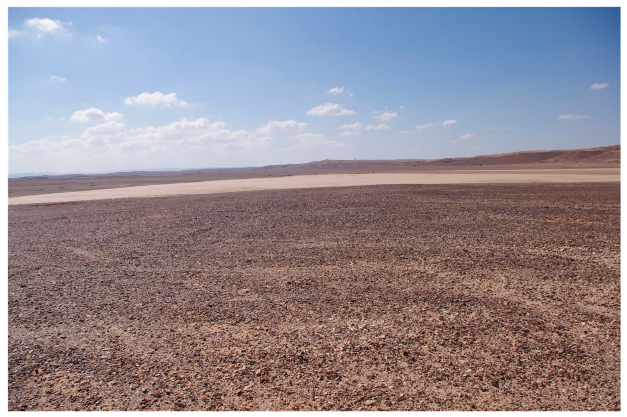
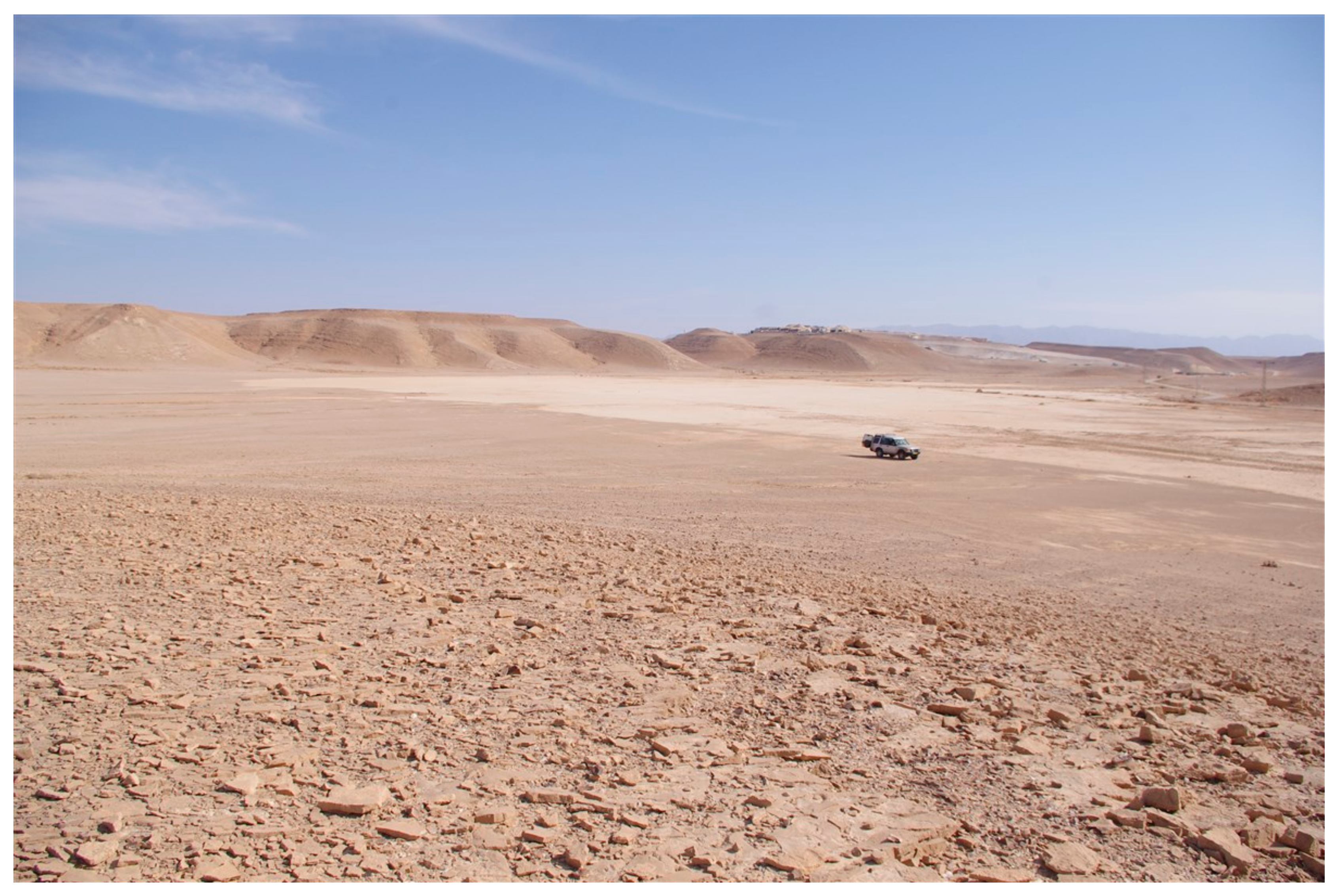
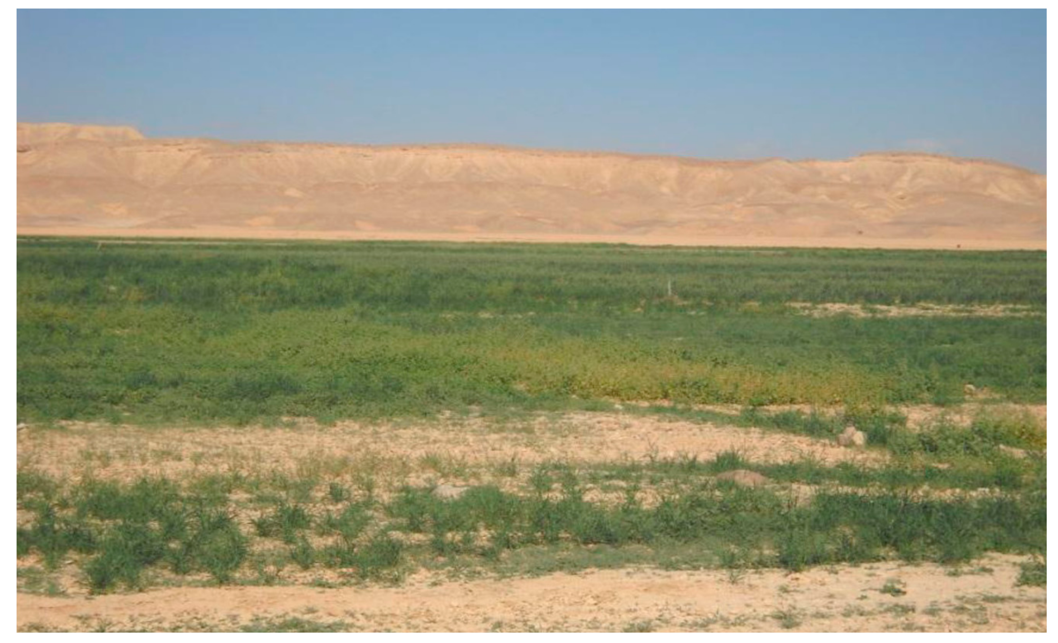
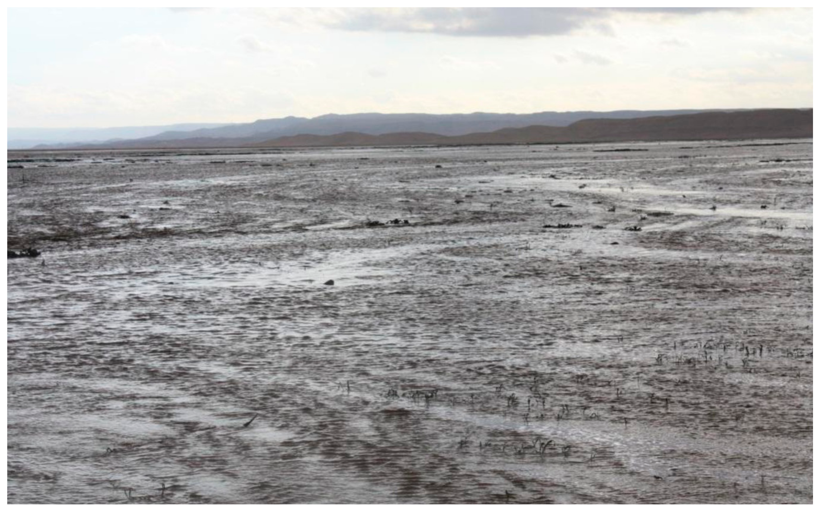
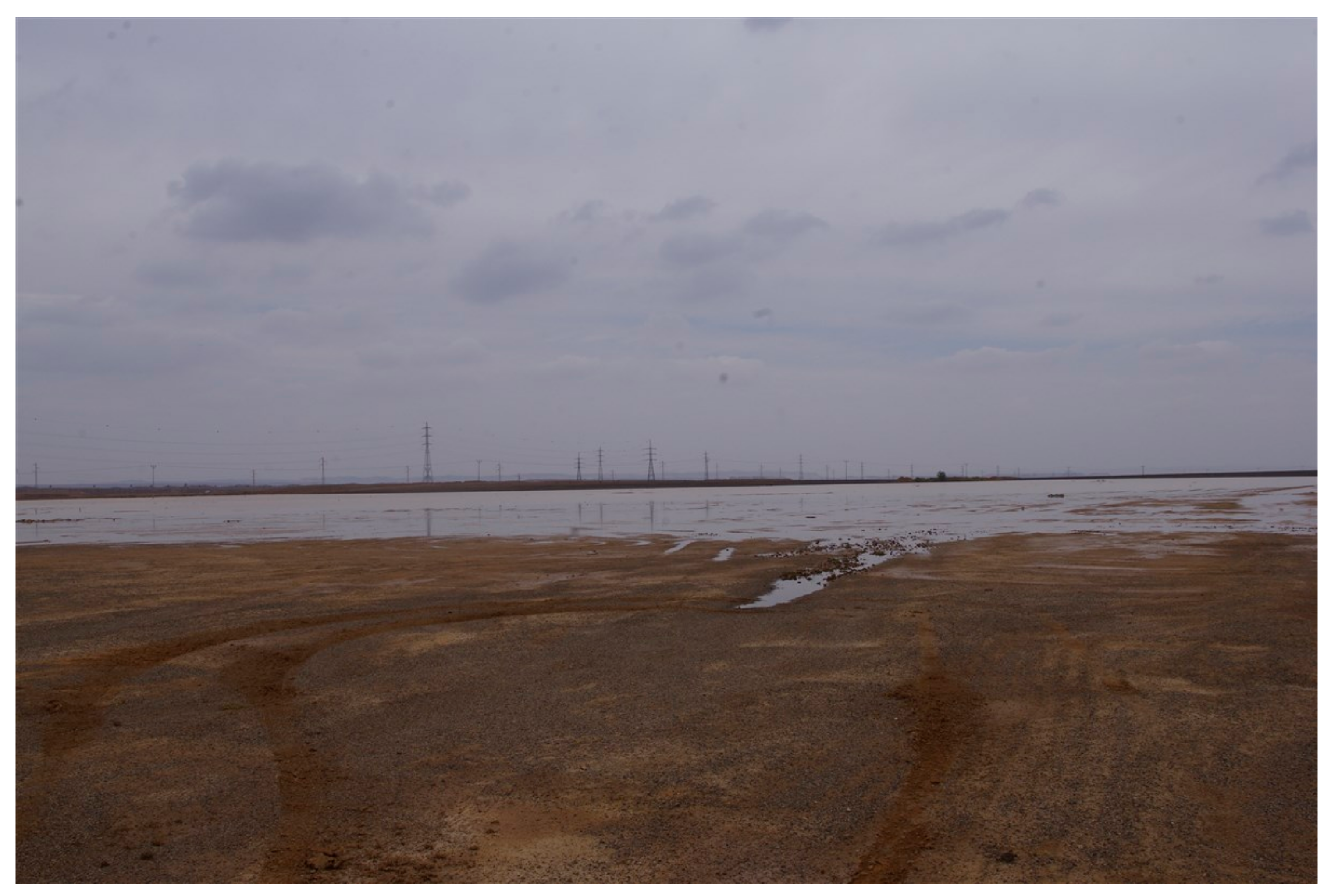
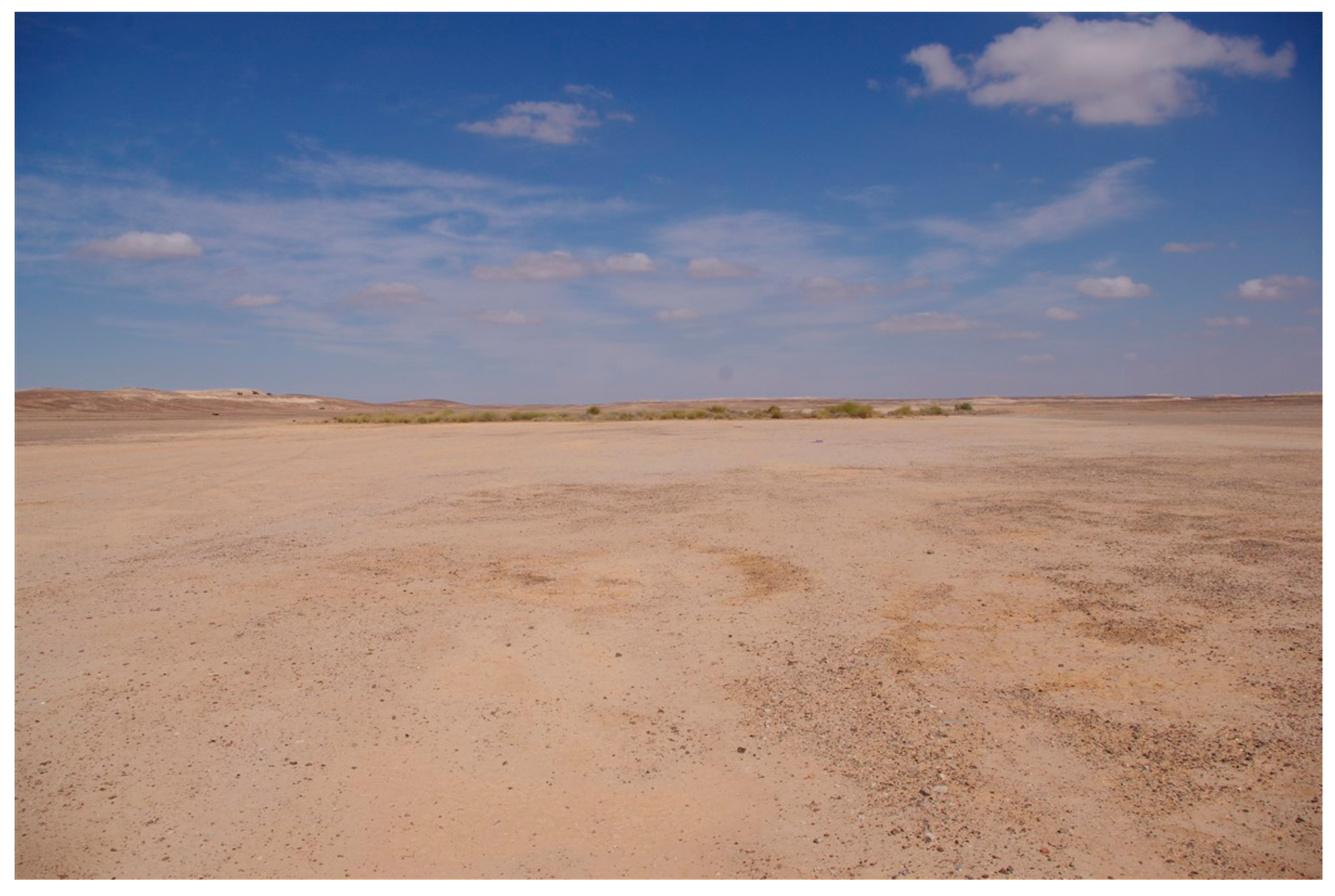
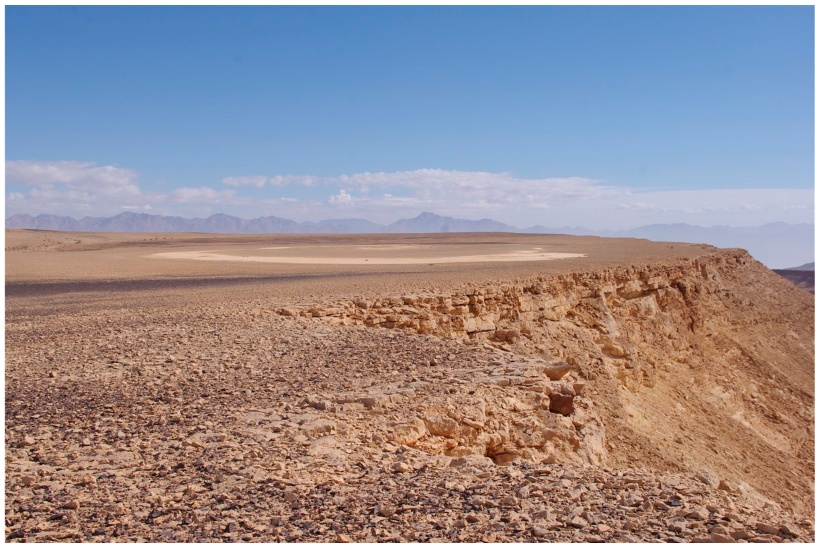
3.1. The Features of Recharge Playas

Our observations at the study sites revealed that contrary the common characterization of playas as closed depressions with no surface outlet [3,5,7], only two (Se’ipim and Re’u’el) of the studied playas are terminal. At the same time, the remainder of the playas, including El-Sa’edin, Shizafon, Shaharut and Girzi, are not absolutely terminal. This feature is attributed to extreme floods, which result in the playa’s lowest rim breaking out, allowing water overland flow to drain into the wadis of Sha’alab, Shizafon, Shaharut and Girzi, respectively. The non-terminal nature of these playas means they are controlled not only by ponding processes, but also by erosional processes. Therefore, unlike the unidirectional aggradation of playas [3], a large number of our playas has experienced aggradation-subsidence cycles over time, which keep their evolution rather dynamic and bi-directional.
The Shizafon Playa (Qa Shizafon) encompasses a flat, extensive area of deep clay deposit. Despite recent extensive earthworks on the playa’s surroundings and a modern road paved on its lowermost edge, the playa’s hydraulic functioning seems to be generally undisturbed, allowing its inundation (Figure 3), as well as its drainage to the Wadi Shizafon.
While monitoring the Girzi Playa’s (Qa Girzi) boundaries in the field, we noticed the location of two bottoms, one at its northernmost edge and another at its southernmost edge. A water divide, stretching approximately on an east-west axis, was found to separate the two depressions. This was confirmed by measurements with a high resolution (dm-scale) GPS, revealing a vertical difference of 0.5 m between the water divide (580.5 m a.s.l.) and the bottom of the northern basin (580.0 m a.s.l.) and 0.1 m between the water divide and the bottom of the southern basin (580.4 m a.s.l.). The northern basin (Girzi Playa: Figure 4) was found to be non-terminal, with an outlet to the Wadi Girzi. At the same time, the southern basin (Figure 5) was found to be terminal. We named this basin “Avraham Playa”, adopting the name of an old, non-paved airfield, which was operated nearby in the mid-twentieth century.
The fieldwork at the Girzi and Avraham playas was conducted in early November 2016, eight days after a substantial rainstorm derived from a Sudanese sub-tropical high pressure cell, which resulted in the inundation of both of the playas. Due to the very erratic rainstorms and floods during the study year, the specific moisture conditions of soil were not measured. Yet, qualitative observations suggested that this rainstorm caused the considerable wetting of these playas’ beds. Furthermore, qualitative observations in the Girzi Playa’s bottom revealed that compared to the surrounding wadis, the shrubby and chamaephyte vegetation, dominated by Ochradenus baccatus Delile, Pituranthos triradiatus Hochst. ex Boiss., Artemisia sieberi Besser, Moricandia nitens (Viv.) E.A. Durand & Barratte, Zilla spinosa (L.) Prantl, Asteriscus graveolens (Forssk.) Less. and Astragalus spinosus (Forssk.) Muschl., had a fresh-green appearance. Further, dense germination of herbaceous vegetation was observed at the bottom of this playa. At the same time, no wetting, greening of shrubby plants, nor germination of herbaceous vegetation were observed for the Wadi Girzi floor, indicating the playa’s lower edge had not been broken by the inundated water of this rainstorm. Rain gauges distributed across the region revealed a rainfall depth of 5–10 mm for this storm. This accords with our interpretation for some of the recharge playas of our study region as terminal for relatively light-to-moderate rainstorms and non-terminal for heavy rainstorms.
The Se’ipim Playa (Qa Se’ipim: Figure 6) was found to be terminal and of a crescent shape. The substantially small area of this playa compared with the other playas is determined by the location on a highland plateau, with a limited-sized drainage basin. This also explains the far shallower depth (0.4–0.5 m) of its bed compared to that of the other playas. Probably, these features of the Se’ipim Playa have limited water availability in its bed. This was also consistent with the complete exposure of the bed surface from any vegetation. Regardless, the remains of two recent-past (Bedouin) cistern-like pits dug in the playa’s bed (~2 m diameter each: Figure 7) were found. The pits were fully covered with sediments, which penetrated through an inlet in a surrounding earth embankment of approximately 0.5 m thick.
The Re’u’el Playa (Qa Re’u’el: Figure 8) was found to be even smaller than the Se’ipim Playa. This playa is terminal and located at a distance of approximately five meters from the Shaharut Cliff. Maximal soil depth at this playa ranges between 0.3 m and 0.4 m. Despite the shallow depth of soil, in a visit in January 2017, the playa bed had a sparse vegetation cover. This included the shrub species of Zygophyllum dumosum Boiss. and several chamaephyte species, including Asteriscus graveolens (Forssk.) Less., Diplotaxis acris (Forssk.) Boiss., Fagonia sinaica Boiss. and Trigonella stellata Forssk. Several archaeological sites located close to the playa have been recorded by Avner [20] and dated to the Bronze Age.
Overall, lithology, areal bed cover and basin size of the studied recharge playas were found to vary greatly (Table 1). Depth of the bed for all of the playas except for Se’ipim and Re’u’el was found to exceed 1 m. Monitoring of the Ketura Playa was negated due to security regulations.

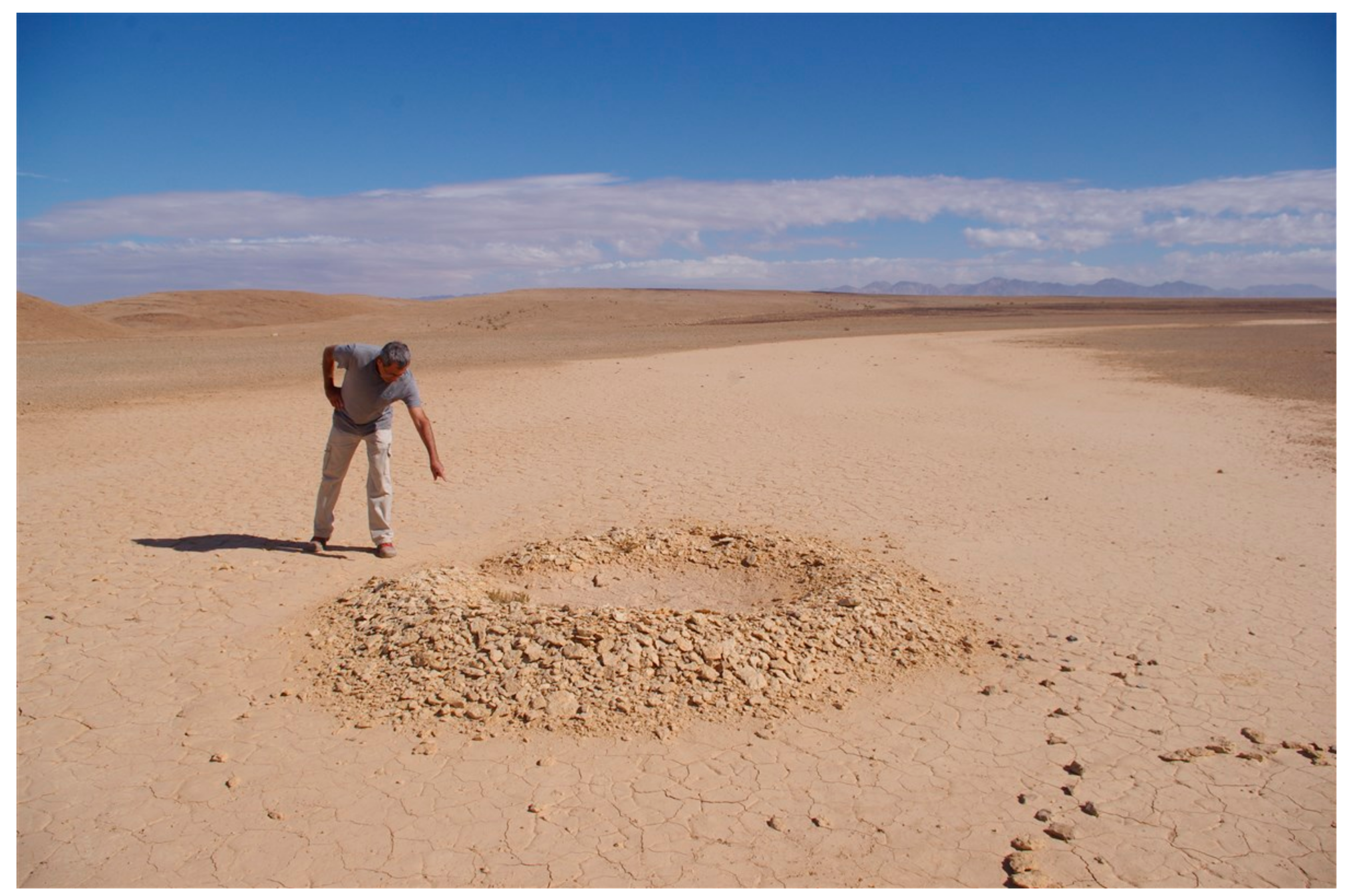
3.2. Indicators of Ancient to Recent-Past Runoff Agriculture

In the Shaharut Playa (Qa Shaharut: Figure 9), ancient farming land use was indicated by the remains of seven stone terraces across its lower part, revealing the practicing of runoff harvesting agriculture. It is suggested that the purpose of the terraces was to spread runoff water widthwise the playa bed, allowing a wider area to be exposed to considerable wetting. Furthermore, in extreme floods, runoff harvested in these terraces would be protected from becoming drained to the downstream Wadi Shaharut. Structural characteristics of these terraces are similar to those of many agricultural runoff harvesting infrastructures that were located in many ephemeral stream channels across southern Israel and dated to the Byzantine Age (fourth to seventh century AD) [21,22,23]. As elsewhere, agricultural utilization of Byzantine runoff harvesting infrastructures during later ages is very probable [22,23]. For example, evidence for modern agricultural land use was provided for terraced lands in some wadis across the central Arava Valley by the location of tillage-induced shallow soil furrows, which indicate recent (decades old) tillage by Bedouins [24]. This was further indicated by the on-site location of several characterizing metal duck-foot plow tips and related wooden frames [25,26]. Furthermore, this was evidenced through testimonies by key Bedouin informants, who pointed out agricultural practice in some of the terraced wadis across the central Arava Valley and the Uvda Valley until the mid-twentieth century (personal communications with Gidon Ragolsky and Uzi Avner). It is acknowledged that Bedouin populations across the region have not established agricultural runoff harvesting systems [26]. At the same time, it is also acknowledged that the Bedouin invested in the maintenance of such ancient systems (personal communication with Uzi Avner). Historical human activities across the site were indicated by the many pottery fragments dated to the Byzantine, Nabatean, and Islamic ages, which were found in the Shaharut Playa and its vicinities. Furthermore, the findings of flint stone adzes and sickle blades in the vicinities of this site indicate agricultural activities as early as the Late Neolithic age (6450–4550 BC) [27].
The dense cover of herbaceous vegetation in the El-Sa’edin Playa (Qa el-Sa’edin) after inundation (Figure 10) indicates high production capacity. This accords with a visit to this playa at the end of the 2016 dry season, which revealed extensive vegetation patches, comprised of annual grasses and forbs, as well as dense shrubby vegetation, dominated by Salsola tetrandra Forssk., Anabasis articulata (Forssk.) Moq. and Haloxylon persicum Bunge. This could also suggest a potential use for runoff agriculture in the ancient to recent past. This suggestion consists with rare bibliographic sources, recording the tillage of the El-Sa’edin Playa by Bedouin populations in the 1930s and 1940s [28,29]. In his essay, Breslavi [29] mentioned that in this playa, in addition to barley and wheat, the local Bedouin used to grow summer cultivars, such as sorghum (Sorghum bicolor (L.) Moench) and other hybrids of the subfamily of Panicoideae. In order to produce fair yields, the growing of such summer crops requires a considerable amount of late-season rains [30]. Further, local key informants provided testimonies for a later agricultural land use in this playa, indicating cereal cropping by Jordanian Bedouin in extremely rainy years up to the mid-1990s (personal communication with Gidon Ragolsky). Regardless, the location of many pottery fragments, dated to the Roman (63 BC–324 AD), Byzantine (324–638 AD), Early Islamic (638–1099 AD), Late Islamic (1099–1516 AD), Ottoman (1516–1917 AD) and modern (1917 AD to the mid-twentieth century) ages in the surroundings of this playa indicates a wealth of human activities throughout history.

3.3. Evaluating Meteorological Conditions and Agronomic Potential

The generation of Hortonian overland flow has been primarily attributed to rainstorm intensity [31]. Effective rains, i.e., rainstorms that generate water overland flow, were determined for the hyper-arid southern Israel to be those >6 mm of rainfall in a day [32]. On a 17-year basis (2000/01–2016/17), for the Neot Smadar meteorological station (pertaining to all of the studied playas except El-Sa’edin), effective rains were reported three times (18%) for October, none (0%) for November, four times (24%) for December, twice (12%) for each of the months of January–March and three times (18%) for April. For the Yotvata meteorological station (pertaining to the El-Sa’edin Playa), processing of rainfall data revealed that on a 14-year basis (2000/01–2013/14), effective rains occurred only for December (three times: 21%), January (once: 7%) and February (three times: 21%). For both of the meteorological stations, no more than a single effective rainstorm per month occurred during this 17- or 14-year period. Long-term, seasonal mean depth of effective rain events was 11.7 mm for Neot Smadar and 7.2 mm for Yotvata. For Neot Smadar, out of the effective rainstorms, only a few had a depth of 10–20 mm (a total of six events), 20–30 mm (two events) and >30 mm (no events). The corresponding values for Yotvata are five, one and zero (Table 2).
Calculation of the depth of the water column at the bed of each of the playas, due to runoff generated from the catchment excluding that from adjacent hillslopes, revealed very few scenarios of >200 mm, of which most (4/5 of possible scenarios) were generated under 30 mm rainstorms and high (0.30) Cr. Furthermore, more than half (3/5) of the possible scenarios are relevant for the Re’u’el Playa (Table 3). Calculating the water column depth at the playa bed due to runoff generated from adjacent hillslopes revealed a generally similar state, for which most (3/4) relevant scenarios are generated under 30-mm rainstorms and high (0.55) Cr, and pertaining to the Re’u’el Playa (Table 4). Adding together the runoff generated from the entire catchment and adjacent hillslopes yielded a >200-mm water column at the bed of El-Sa’edin (for the combination of 20 mm rainstorms or more and highest-to-mid Cr, respectively), Shaharut, Se’ipim (for the combination of 30-mm rainstorms and high Cr), Avraham (for 30-mm rainstorms and under almost the entire range of Cr) and Re’u’el (for the combination of 10-mm rainstorms and high Cr and for 20-mm or more rainstorms under the entire range of Cr) (Table 5).
Stavi et al. [17] calculated that early-season (October) rainstorms that generate a 200-mm run-on column depth at sink sites could hardly support the successful production of barley or wheat in the southern Negev highlands. At the same time, they calculated that early-season rains, which generate a 300-mm run-on column depth or more, would certainly support crop production. Furthermore, they calculated that if the first rainstorm occurs on mid-season (December), hardly any successful crop could emerge under a 300-mm run-on column depth, while a successful yield is promised under a 400-mm run-on column depth. Additionally, Stavi et al. [17] showed that, for any run-on column depth at sink sites, no successful cropping is possible if the first rainstorm occurs in late January or later. Therefore, of the total eight rainy years for Neot Smadar during the 17-year period between 2000/01 and 2016/17, only six could be relevant in agronomic terms. Similarly, for the total of four rainy years for Yotvata during the 14-year period between 2000/01 and 2013/14, only three could have had agronomic relevance.
For the southern Arava Valley, calculated ETc seasonal for barley or wheat is presented in Table 6. Overall, values for ETc seasonal in this table are comparatively greater than those for the southern Negev highlands (see [17]). The difference between the two regions is attributed to the 14% greater ETo in the southern Arava Valley (1990-mm yearly average for 2005–2015: [14]) than that in the southern Negev highlands (1750-mm yearly average for 2007–2015: [14]). Calculation of D revealed crop water deficit for 200 mm run-on column depth at sink sites under all combinations of crop × sowing date × growing season length × ETc. Under a 300-mm run-on column depth generated by early-season (October) rainstorms, crop water surplus allows the successful production of barley or wheat. Over the long run, the absence of rainfall in November (Table 2) negates the sowing of crops in mid-season (December). Late-season (January) rainstorms generating a 300-mm run-on column depth would cause crop water deficit under all possible combinations. Early-season rainstorms generating a 400-mm run-on column depth would yield crop water surplus under all possible combinations. Mid-season rainstorms generating a 400-mm run-on depth would allow successful production of either barley or wheat, if the length of the growing season is 120 days only (Table 6). However, as shown in Table 5, the maximum potential water column depth in the El-Sa’edin Playa (which pertains to the southern Arava Valley’s climatic conditions) is 310 mm.
Regardless, considering the dependence of water storage on the soil layer thickness at the sink sites, it is expected that for most of the recharge playas across the study region, soil-water could be extracted by deep-rooted crops. Notable among these crops are barley and wheat, of which their root system can easily reach down to a depth of between one meter [18] and two meters [33]. At the same time, the shallow soil depth in the playas of Se’ipim and Re’u’el is expected to limit the storage of soil-water, reducing the potential agronomic productivity.

3.4. Data Integration and Implications

Results of this study show the highest potential for considerable run-on accumulation in the Re’u’el Playa. However, the very small dimensions and relatively shallow soil depth in this playa are assumed to negate agricultural practice in its bed during ancient times up to the recent past. Furthermore, the results show the potential for considerable run-on accumulation in the El-Sa’edin Playa. However, due to the comparatively inferior climatic conditions across the southern Arava Valley, the only relevant scenario is the combination of a 30-mm rainstorm occurring in the early season and assuming a high runoff coefficient for both the adjacent hillslopes and the entire catchment. In this regards, large-scale rainstorms that could at present cover the entire catchment of this mega-playa are unlikely. Yet, as shown by Tubi and Dayan [34], occasional storms created by synoptic conditions of tropical plumes can potentially cover extensive areas and generate intense and long-lasting rainstorms.
Under very intense rainstorms (>30 mm) and considering the high runoff coefficient, cereal productivity could also be viable for two additional playas, including the Shaharut and Avraham. Despite accumulating potentially sufficient run-on under such conditions, the relatively small size and shallow soil depth of the Se’ipim Playa have probably prevented agricultural practice in its bed during ancient times, up to the recent past.
Overall, this study shows that assuming a sufficient source:sink ratio (runoff contributing area:run-on accumulating area), the cropping of cereals in recharge playas could be viable, even in such harsh environments. Yet, due to the erratic climate, with the extremely high inter-annual variability of rainfall in this hyper-arid region, this practice may not be able to take place on an annual basis, but rather on an episodic basis. One way or another, the obtained results accord with the study hypotheses, indicating agricultural practicing between ancient times and the recent-past, at least in some of the playas, and at the same time, show no potential for sustaining runoff agriculture under current climatic conditions. Regardless, this study demonstrates the profound environmental comprehension by the ancient to recent-past local inhabitants.
Furthermore, the results of this study accord with previous studies, which revealed the region’s drier climatic conditions at present compared to those during most of the Holocene [35], the preindustrial era, modern times [36] and even during the mid-1990s [37]. Additional research is needed to date sediments trapped in the upstream of the Shaharut Playa’s stone terraces. Furthermore, further research is needed to search for indications of agricultural practices in additional recharge playas, both across the Middle East and in other dryland regions around the world.

4. Conclusions

Recharge playas are prevalent across the hyper-arid southern Israel. Archaeological stone terraces located in one playa and testimonies provided by local inhabitants regarding cereal farming in another playa until the mid-1990s indicate the potential for agricultural production in this type of landform. Agro-hydrological assessments of barley and wheat production under the current climatic conditions revealed a marginal agronomic potential, and only for some of the playas. Coinciding with the evidence of ancient to recent-past agriculture in two of the studied playas, the results of this study accord with previous studies, which reported better regional climatic conditions over ancient to recent history than those at present.

Acknowledgments

The authors are grateful to Talia Horovitz from the Israel Meteorological Service for providing the long-term meteorological data for the study region. Furthermore, the authors are grateful to two anonymous reviewers, whose comments allowed the considerable improvement of the manuscript. The study was supported by the Israeli Ministry of Science and Technology.

Author Contributions

Ilan Stavi designed the study, reviewed literature and drafted the manuscript. Rahamim Shem-Tov performed the GIS work. Gidon Ragolsky performed the field work. Judith Lekach performed the hydrological assessments.

Conflicts of Interest

The authors declare no conflict of interest. The founding sponsors had no role in the design of the study; in the collection, analyses or interpretation of data; in the writing of the manuscript; nor in the decision to publish the results.

References

  1. Rosen, M.R. The importance of groundwater in playas: A review of playa classifications and the sedimentology and hydrology of playas. In Paleoclimate and Basin Evolution of Playa Systems; Rosen, M.R., Ed.; Geological Society of America: Boulder, CO, USA, 1994. [Google Scholar]
  2. Goudie, A.S. Pans. Prog. Phys. Geogr. 1991, 15, 221–237. [Google Scholar] [CrossRef]
  3. Shaw, P.A.; Bryant, R.G. Pans, playas and salt lakes. In Arid Zone Geomorphology: Processes, Form and Change in Drylands; Thomas, D.S.G., Ed.; John Wiley & Sons: Chichester, UK, 2010. [Google Scholar]
  4. Goudie, A.S.; Wells, G.L. The nature, distribution and formation of pans in arid zones. Earth-Sci. Rev. 1995, 38, 1–69. [Google Scholar] [CrossRef]
  5. Gurdak, J.J.; Roe, C.D. Recharge Rates and Chemistry beneath Playas of the High Plains Aquifer—A Literature Review and Synthesis; US Geological Survey: Reston, VA, USA, 2009.
  6. Gillette, D.A.; Niemeyer, T.C.; Helm, P.J. Supply-limited horizontal sand drift at an ephemerally crusted, unvegetated saline playa. J. Geophys. Res. 2001, 106, 18085–18098. [Google Scholar] [CrossRef]
  7. Rodríguez-Rodríguez, M. Hydrogeology of ponds, pools, and playa-lakes of southern Spain. Wetlands 2007, 27, 819–830. [Google Scholar] [CrossRef]
  8. Briere, P.R. Playa, playa lake, sabkha: Proposed definitions for old terms. J. Arid Environ. 2000, 45, 1–7. [Google Scholar] [CrossRef]
  9. Nicoll, K. Geoarchaeological perspectives on Holocene climate change as a civilizing factor in the Egyptian Sahara. In Climates, Landscapes, and Civilizations; Giosan, L., Fuller, D.Q., Nicoll, K., Flad, R.K., Clift, P.D., Eds.; Wiley: Hoboken, NJ, USA, 2012; pp. 157–162. [Google Scholar]
  10. Nicoll, K. Nabta playa: Agriculture and domestication. In Encyclopedia of Global Archaeology; Springer: New York, NY, USA, 2014; pp. 5131–5134. [Google Scholar]
  11. Ron, M.; Shalmon, B.; Alon, D.; Ramon, U. Survey, Analysis, and Assessment of Natural Resources, Nature, and Human Heritage; DESHE: Tel Aviv, Israel, 2003. (In Hebrew) [Google Scholar]
  12. Rabinovich, R.; Ginat, H.; Schudack, M.; Schudack, U.; Ashckenazi-Polivoda, S.; Rogolsky, G. A late Cretaceous elasmosaurid of the Tethys Sea margins (southern Negev, Israel), and its palaeogeographic reconstruction. Neth. J. Geosci. 2015, 94, 73–86. [Google Scholar]
  13. Burg, A.; Zilberbrand, M.; Yechieli, Y. Radiocarbon variability in groundwater in an extremely arid zone—The Arava Valley, Israel. Radiocarbon 2013, 55, 963–978. [Google Scholar] [CrossRef]
  14. Israel Meteorological Service Website. Available online: http://www.ims.gov.il/ims/all_tahazit/ (accessed on 25 September 2017).
  15. GRASS GIS. Grass Development Team, Geographic Resources Analysis Support System Software. Open Source Geospatial Foundation Project. 2012. Available online: http://grass.osgeo.org (accessed on 25 September 2017).
  16. ASTER GDEM. Maintained by the NASA Land Processes Distributed Active Archive Center (LP DAAC). Available online: https://lpdaac.usgs.gov (accessed on 25 September 2017).
  17. Stavi, I.; Shem-Tov, R.; Ragolsky, G.; Lekach, J. Ancient runoff harvesting agriculture in the hyper-arid Uvda Valley of Israel: An agro-hydrological assessment. Land Degrad. Dev. 2017, 28, 2155–2165. [Google Scholar] [CrossRef]
  18. Allen, R.G.; Pereira, L.S.; Raes, D.; Smith, M. FAO Irrigation and Drainage Paper No. 56; Food and Agriculture Organization of the United Nations: Rome, Italy, 1990; Available online: http://www.kimberly.uidaho.edu/water/fao56/fao56.pdf (accessed on 25 September 2017).
  19. Eldridge, D.J.; Zaady, E.; Shachak, M. Infiltration through three contrasting biological soil crusts in patterned landscapes in the Negev, Israel. Catena 2000, 40, 323–336. [Google Scholar] [CrossRef]
  20. Avner, U. Uvda—Site#135, Archaeological Survey, 2006. non-published report. (In Hebrew)
  21. Erickson-Gini, T. Nabataean agriculture: Myth and reality. J. Arid Environ. 2012, 86, 50–54. [Google Scholar] [CrossRef]
  22. Avni, G.; Porat, N.; Avni, Y. Byzantine-Early Islamic agricultural systems in the Negev Highlands: Stages of development as interpreted through OSL dating. J. Field Archaeol. 2013, 38, 332–346. [Google Scholar] [CrossRef]
  23. Ashkenazi, E.; Chen, Y.; Avni, Y.; Lavee, S. Fruit trees’ survival ability in an arid desert environment without irrigation in the Negev Highlands of southern Israel. Isr. J. Plant Sci. 2015, 62, 5–16. [Google Scholar] [CrossRef]
  24. Stavi, I.; Ragolsky, G.; Shem-Tov, R.; Shlomi, Y.; Ackermann, O.; Rueff, H.; Lekach, J. Ancient through mid-twentieth century runoff harvesting agriculture in the hyper-arid Arava Valley of Israel. Catena 2018, 162, 80–87. [Google Scholar]
  25. Ragolsky, G. Human Culture Sites in the Menuha Ridge; Dead Sea and Arava Science Center: Newe Zohar, Israel, 2016. (In Hebrew) [Google Scholar]
  26. Avner, U. Settlement, agriculture and paleoclimate in Uvda Valley, southern Negev desert, 6th–3rd Millennia BC. In Water, Environment and Society in Times of Climatic Change; Issar, A.S., Brown, N., Eds.; Kluwer Academic Publishers: Dordrecht, The Netherlands, 1998; pp. 147–202. [Google Scholar]
  27. Avner, U. Uvda Archaeological Survey, 1981. non-published report. (In Hebrew)
  28. El-Aref, A. Beer Sheva and Its Tribes—The Bedouin Tribes in Beer Sheva County, 5th ed.; Ariel Publishing: Jerusalem, Israel, 1937. (In Hebrew) [Google Scholar]
  29. Breslavi, J. Aqaba, 2nd ed.; Israel Marine Center Publishing House: Haifa, Israel, 1948. (In Hebrew) [Google Scholar]
  30. Eggenberger, W.; Lemessa, D. Belg Rains Are Late: North Central Ethiopia Once Again Faces Difficult Year; Report of a Field Mission to Welo; University of Pennsylvania—African Studies Center: Addis Ababa, Ethiopia, 2000; Available online: http://www.africa.upenn.edu/Hornet/welo1804.html (accessed on 25 September 2017).
  31. Stomph, T.J.; De Ridder, N.; Steenhuis, T.S.; Van de Giesen, N.C. Scale effects of Hortonian overland flow and rainfall-runoff dynamics: Laboratory validation of a process-based model. Earth Surf. Process. Landf. 2012, 27, 847–855. [Google Scholar] [CrossRef]
  32. Soil Erosion Research Station (SERS). Spatial Statistical Model for Assessing Annual Runoff Quantities in Drainage Basins in the Southern Negev and Arava; Soil Erosion Research Station: Rishon LeẔiyyon, Israel, 1996. (In Hebrew) [Google Scholar]
  33. Steduto, P.; Hsiao, T.C.; Fereres, E.; Raes, D. Crop Yield Response to Water. FAO Irrigation and Drainage Paper No. 66; Food and Agriculture Organization of the United Nations: Rome, Italy, 2012; Available online: http://www.fao.org/docrep/016/i2800e/i2800e.pdf (accessed on 25 September 2017).
  34. Tubi, A.; Dayan, U. Tropical Plumes over the Middle East: Climatology and synoptic conditions. Atmos. Res. 2014, 145–146, 168–181. [Google Scholar] [CrossRef]
  35. Black, E.; Brayshaw, D.J.; Rambeau, C.M.C. Past, present and future precipitation in the Middle East: Insights from models and observations. Philos. Trans. R. Soc. Lond. A 2010, 368, 5173–5184. [Google Scholar] [CrossRef] [PubMed]
  36. Kaniewski, D.; Van Campo, E.; Weiss, H. Drought is a recurring challenge in the Middle East. Proc. Natl. Acad. Sci. USA 2012, 109, 3862–3867. [Google Scholar] [CrossRef] [PubMed]
  37. Ginat, H.; Shlomi, Y.; Batarseh, S.; Vogel, J. Reduction in precipitation levels in the Arava Valley (southern Israel and Jordan), 1949–2009. J. Dead-Sea Arava Res. 2011, 1, 1–7. [Google Scholar]
Figure 1. Map of Israel, with an extension of the study region.
Water 09 00991 g001
Figure 2. The El-Sa’edin Playa (Qa el-Sa’edin) under inundation. The picture was taken on 31 January 2013 by Boaz Langford. Reproduced with permission from the photographer.
Water 09 00991 g002
Figure 3. Shizafon Playa (Qa Shizafon) under inundation. The picture was taken on 14 April 2017, one day after a heavy rainstorm, by Ilan Stavi.
Water 09 00991 g003
Figure 4. Girzi Playa (Qa Girzi), a northward sight. Notice the dense shrubby vegetation in the playa’s bottom. Picture taken by Ilan Stavi.
Water 09 00991 g004
Figure 5. Avraham Playa (Qa Avraham), a southward sight. Notice the playa’s terminal bottom. Picture taken by Ilan Stavi.
Water 09 00991 g005
Figure 6. Se’ipim Playa (Qa Se’ipim), a southward sight. Notice the playa’s crescent shape. Picture taken by Ilan Stavi.
Water 09 00991 g006
Figure 7. Remains of a cistern-like pit, dug in the Se’ipim Playa’s bed. In the picture, Rahamim Shem-Tov points to the pit’s drainage inlet in the surrounding earth embankment. Picture taken by Ilan Stavi.
Water 09 00991 g007
Figure 8. Re’u’el Playa (Qa Re’u’el), an eastern site. Notice the Shaharut Cliff’s edge at the right side of the playa. Picture taken by Ilan Stavi.
Water 09 00991 g008
Figure 9. Shaharut Playa (Qa Shaharut), an eastward sight. Picture taken by Ilan Stavi.
Water 09 00991 g009
Figure 10. Dense herbaceous vegetation cover in the El-Sa’edin Playa (Qa el-Sa’edin), following the 31 January 2013 inundation. The picture was taken on 18 March 2013 by Boaz Langford. Reproduced with permission from the photographer.
Water 09 00991 g010
Table 1. Physical characteristics of the studied recharge playas.
Recharge PlayaEl-Sa’edin ShizafonShaharutGirziAvrahamSe’ipimRe’u’el
Central longitude (°)30.10815730.11317829.92325129.96947229.96432329.68926429.925556
Central latitude (°)35.17908135.00821434.99497434.85944734.85976934.88493935.008278
Mean altitude (m a.s.l.)194340469580580792525
Depression bed area (km2)8.70.1880.1330.0370.0560.0070.00042
Drainage basin area (km2)2852.233.6620.3740.9270.1120.0263
Adjacent hillslopes area (km2)27.71.030.590.3740.9270.080.01
Note: For the playas Girzi and Avraham, no inlet exists from stream channels.
Table 2. Long-term data of the depth (mm) of effective rainstorms (>6 mm) for the Neot Smadar and Yotvata meteorological stations.
Neot Smadar * Yotvata **
Year/MonthOctoberNovemberDecemberJanuaryFebruaryMarchAprilTotalOctoberNovemberDecemberJanuaryFebruaryMarchAprilTotal
2000–2001000000000013.2000013.2
2001–20020070008.815.800000000
2002–20030000000000000000
2003–2004000011.20011.20018.2010.30028.5
2004–2005000006.306.300000000
2005–20060000000000000000
2006–20070000000000000000
2007–20080000000000000000
2008–20090000000000000000
2009–201000019.59.40028.500022.317.60039.9
2010–201100000000008.100008.1
2011–20120000000000000000
2012–201320.00000002000000000
2013–201400000000000010.70010.7
2014–2015007.86.700013.7NANANANANANANANA
2015–201619.706.50021.56.653.6NANANANANANANANA
2016–201711.3010.400028.749.4NANANANANANANANA
Mean2.90.01.81.51.31.62.611.70.00.02.81.62.80.00.07.2
# years with 10–20 mm rainstorms3011100600203005
# years with 20–30 mm rainstorms0000011200010001
# years with >30 mm rainstorms0000000000000000
Notes: * Data for Neot Smadar were modified from Stavi et al. [17] for the years 2000/01 through 2015/16, and obtained from the Israel Meteorological Service website [14] for 2016/17. Pertaining to all playas, but the El-Sa’edin. ** Data for Yotvata were obtained from the Israel Meteorological Service website [14]. Pertaining to the El-Sa’edin Playa. NA, not available.
Table 3. Potential water column depth (mm) over the recharge playa’s bed due to runoff generated from the catchment, excluding the playa’s adjacent hillslopes, and according to rainfall depth and runoff coefficient (Cr).
Rain Over Source Area (mm) 102030102030
PlayaSource: Sink RatioCr = 0.15Cr = 0.30
El-Sa’edin31.8489514395191286
Shizafon10.9163349336698
Shaharut26.7408012080160240
Girzi9.1142741275582
Avraham15.62347704793140
Se’ipim152345684590135
Re’u’el61.692185277185370555
Notes: Rainfall amounts were selected arbitrarily for small, medium, and large storms of 10 mm, 20 mm, and 30 mm, respectively, which represent the study region [14]. Cr of 0.15 and 0.3 were chosen due to the defining physical characteristics of catchments over southern Israel [17]. Calculations are based on the assumption that runoff was not lost to downstream flow.
Table 4. Potential water column depth (mm) over the recharge playa’s bed due to runoff generated from adjacent hillslopes, and according to rainfall depth and runoff coefficient (Cr).
Rain Over Source Area (mm) 102030102030
PlayaSource:Sink RatioCr = 0.25Cr = 0.55
El-Sa’edin3.281624183553
Shizafon5.5142841306191
Shaharut4.4112233244973
Girzi10.125517656111167
Avraham16.6418312491182273
Se’ipim11.529588663127190
Re’u’el28.170140211155309464
Notes: Rainfall amounts were selected arbitrarily for small, medium, and large storms of 10 mm, 20 mm, and 30 mm, respectively, which represent the study region [14]. The relatively high Cr values (0.25–0.55) were chosen due to the study region’s hillslopes, which are defined by a rocky surface and shallow reg soils. Calculations are based on the assumption that runoff was not lost to downstream flow.
Table 5. Potential water column depth (mm) over the recharge playa’s bed due to runoff generated from the entire catchment, including the playa’s adjacent hillslopes, and according to rainfall depth.
Rain Over Source Area102030
Playa
El-Sa’edin5 –103102–206152–310
Shizafon22–4744–9366–140
Shaharut44–9189–182133–273
Girzi40–5681–111121–167
Avraham66–91132–182199–273
Se’ipim34–7468–148102–221
Re’u’el121–255241–510362–765
Note: Rainfall amounts were selected arbitrarily for small, medium, and large storms of 10 mm, 20 mm, and 30 mm, respectively, which represent the study region [14]. For each combination of rainstorm depth and playa, the range of water column depth over the bed is determined by minimal and maximal runoff coefficients used for calculations. Calculations are based on the assumption that runoff was not lost to downstream flow.
Table 6. Water deficit for the southern Arava Valley (relevant for the El-Sa’edin Playa) according to RUNON depth, crop, sowing date, and crop evapotranspiration.
RUNON Depth (mm)CropSowing DateGrowing Season Length (Days)Crop Evapotranspiration (ETc: mm)Water Deficit (D: mm)
300Barley1 November120229–273(−)78.2–(−)34.2
150311–352(+)3.8–(+)44.8
Wheat 120229–289(−)78.2–(−)18.2
150311–376(+)3.8–(+)68.8
Barley1 January120347–385(+)39.8–(+)77.8
150484–540(+)176.8–(+)232.8
Wheat 120347–402(+)39.8–(+)94.8
150484–564(+)176.8–(+)256.8
Barley1 February120468–517(+)160.8–(+)209.8
150628–696(+)320.8–(+)388.8
Wheat 120468–538(+)160.8–(+)230.8
150628–725(+)320.8–(+)417.8
400Barley1 November120229–273(−)178.2–(−)134.2
150311–352(−)96.2–(−)55.2
Wheat 120229–289(−)178.2–(−)118.2
150311–376(−)96.2–(−)31.2
Barley1 January120347–385(−)60.2–(−)22.2
150484–540(+)76.8–(+)132.8
Wheat 120347–402(−)60.2–(−)5.2
150484–564(+)76.8–(+)156.8
Barley1 February120468–517(+)60.8–(+)109.8
150628–696(+)220.8–(+)288.8
Wheat 120468–538(+)60.8–(+)130.8
150628–725(+)220.8–(+)317.8
Notes: The range of ETc is determined by the Kc. For the calculation of D, the interannual mean seasonal rainfall of 7.2 mm (see Table 2) was considered. Positive D values mean crop’s water deficit, while negative D values (bolded) mean crop’s water surplus.

